Decision rules for determining terrestrial movement and the consequences for ltering high-resolution GPS tracks - A case study using the African ...
←
→
Page content transcription
If your browser does not render page correctly, please read the page content below
Decision rules for determining terrestrial movement
and the consequences for filtering high-resolution
GPS tracks – A case study using the African Lion
(Panthera leo)
Richard Michael Gunner ( 792021@swansea.ac.uk )
Swansea University https://orcid.org/0000-0002-2054-9944
Rory P Wilson
Swansea University College of Science
Mark D Holton
Swansea University College of Science
Phil Hopkins
Swansea University College of Science
Stephen H Bell
Queen's University Belfast School of Biological Sciences
Nikki J Marks
Queen's University Belfast School of Biological Sciences
Nigel C Bennett
University of Pretoria Department of Zoology and Entomology
Sam Ferreira
SANParks: South African National Parks
Danny Govender
SANParks: South African National Parks
Pauli Viljoen
SANParks: South African National Parks
Angela Bruns
SANParks: South African National Parks
O. Louis van Schalkwyk
Government of South Africa, Department of Agriculture, Forestry and Fisheries
Mads F Bertelsen
Center for Zoo and Wild Animal Health, Copenhagen Zoo
Carlos M Duarte
King Abdullah University of Science and Technology
Martin C van Rooyen
University of Pretoria Department of Zoology and Entomology
Page 1/28
Craig J Tambling
University of Fort Hare, Department of Zoology and Entomology
Aoife Goppert
Queen's University Belfast School of Biological Sciences
Delmar Diesel
Queen's University Belfast School of Biological Sciences
D. Michael Scantlebury
Queen's University Belfast School of Biological Sciences
Research Article
Keywords: Acceleration, Animal behaviour, Data filtering, Global Positioning System (GPS), High-
resolution, Speed, Terrestrial movement
DOI: https://doi.org/10.21203/rs.3.rs-600317/v1
License: This work is licensed under a Creative Commons Attribution 4.0 International License.
Read Full License
Page 2/28
Abstract
The combined use of Global Positioning System (GPS) technology and motion sensors within the
discipline of movement ecology has increased over recent years. This is particularly the case for
instrumented wildlife, with many studies now opting to record parameters at high (infra-second)
sampling frequency. However, the detail with which GPS loggers can elucidate fine-scale movement
depends on the precision and accuracy of fixes, with accuracy (specifically, location error and fix success
rate) being affected by signal reception. We hypothesised that animal behaviour was the main factor
affecting fix inaccuracy (particularly for collar-mounted tags sampling at high frequency). In conjunction
to this, inherent GPS positional noise (‘jitter’), would be most apparent during GPS fixes for non-moving
locations, thereby producing disproportionate error during rest periods.

A Movement Verified Filtering (MVF) protocol was constructed to compare GPS-derived speed data to
dynamic body acceleration (DBA). This was collected by a simultaneously deployed tri-axial
accelerometer, to provide a computationally quick method for identifying genuine travelling movement.
This method was tested on 11 free-ranging lions ( Panthera leo ) within the Kgalagadi Transfrontier park
in the Kalahari Desert, fitted with collar-mounted GPS units and tri-axial motion sensors (Daily Diary; DD)
recording at 1 and 40 Hz, respectively.

The findings support the hypothesis and show that distance moved estimates were, on average,
overestimated by > 80 % prior to GPS screening. We present the conceptual and mathematical protocols
for screening fix inaccuracy within high resolution GPS datasets.

We demonstrate the importance that MVF has for avoiding inaccurate and biased estimates of
movement and caution the accuracy of findings from previous studies that employed minimal GPS pre-
processing . Throughout, we address the applicability of comparing fine-scale indices of GPS- and motion
sensor-borne data in tandem to qualify animal behaviour.

1. Introduction
A popular method to determine terrestrial animal movement uses Global Positioning Systems
(GPS), which enables long-term continuous spatial monitoring of wild animals without disturbing
them [for reviews see; 1, 2-5]. This approach has led to broad applications, including examination of
home ranges [6, 7], migratory routes [8-10], habitat use [11, 12], resource allocation [13, 14], activity
budgets [15-17] as well as social interactions [18]. Since their inception, animal-borne GPS’s have reduced
considerably in mass and size, whilst data storage capacity, battery longevity and affordability have
improved [5, 19, 20]. Consequently, scientists can now track animals as small as ca. 20 g songbirds
(Seiurus aurocapilla) [21] at frequencies as high as 10 Hz [e.g., 22], providing so much detail of animal
movement that even animal behaviour can often be inferred [23-25]. Such inference is, however, limited
by fix precision, regardless of fix accuracy, which can be particularly ambiguous when the movement

                                                  Page 3/28
rates of the focal species are less than the spatial resolution of the GPS fixes [26]. Species-specific
resampling strategies and correction factors can go some way to redressing this [cf. 26, 27, 28].

Many factors affect GPS performance including habitat type and heterogeneity [29-32], topography of the
terrain [33, 34], view of the sky availability [35], weather conditions [30], submersion in water [36, 37], time
of day [38], vegetation cover/type [33, 39], GPS orientation [40], fix acquisition rate [41, 42], in addition to
the number of available satellites and their orbiting geometry with respect to one another [43, 44]. All
these elements affect the propagation of signal quality and/or receiver reception capability and thus
increase triangulation error (see Hofman et al. [4] for review), with the latter two factors often assessed
via the dilution of precision (DOP) values [44, 45].

Species-specific movements can be misinterpreted because GPS error often exaggerates the extent of
movement, with error associated with distance measures being additive over time, and particularly
germane at higher sampling frequencies (given that higher rates of error are incorporated per unit
time) [42, 46]. Indeed, although a number of authors have attempted to resolve the accuracy of GPS
performance by quantifying the fix success rate and location error over various scenarios [cf. 47, 48], the
critical modulator of GPS performance is animal behaviour [cf. 40, 49-52]. For example, Heard et al.
[38] demonstrated that fix success rate for GPSs on grizzly bears (Ursus arctos) followed a bimodal
circadian pattern, which was paralleled to the activity time-budgets of the bear, with higher forest density
cover and variability in collar orientation being attributed to declines in fix rate. Similarly, after collaring
both Eurasian lynx (Lynx lynx) and wolverine (Gulo gulo) in similar habitat, Mattisson et al.
[50] suggested that high discrepancy in fix rate between the two species could be explained by
differences in their behavioural repertoire. In essence, the specifics of animal movement, the ‘what’,
‘where’, ‘when’ and ‘how’ [cf. 1], underpins the species interaction with its environment and consequently
the dual proficiency of signal propagation and reception between satellites and receiver. Resting is the
most common behaviour for most terrestrial animals (particularly carnivores) and critically affects fix
accuracy, because resting is typically associated with a change of body position (e.g., resting on the
collar) and/or coverage within/near ‘signal obstructing’ environmental features (e.g., sleeping under trees
or in caves/ burrows), thus decreasing the available sky for the GPS receiver [31-33, 44]. This issue is
compounded for collar-mounted GPS devices, because behaviours variously affect the position of the
GPS antenna even though many collars are designed to be bottom-weighted to minimize this
problem [33, 49, 53].

Despite the well-documented issues of locational error and numerous mitigation strategies being
proposed [54-57], there has been no ‘gold standard’ solution to identify inaccurate fixes. For
example, Lewis et al. [43] emphasised using DOP values, removing fixes with values > 5 and only keeping
positions where ≥ 3 satellites were registered to eliminate potentially large location errors. This
recommendation was based on the premise that a wider geometry of satellite spacing, results in lower
recorded DOP values and this along with a higher number of registered satellites, is associated with
minimising triangulation error. The relationship between spatial precision and increasing DOP values,
whilst generally accepted, is noisy however, and this approach can reduce datasets considerably, whilst
                                                    Page 4/28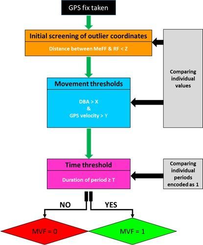
still leaving notably anomalous fixes intact [34, 58]. Juxtaposed to this, Bjørneraas et al. [47] developed a
method that focused on the movement characteristics of the focal species to identify large locational
errors with minimal data reduction. This included screening for unrealistic distances travelled, speeds and
turn angles between successive locations. However, this can become complicated and arbitrary at high
sampling frequencies and is computationally intensive for large data sets.

To our knowledge, a specific solution for screening inaccurate locations from high resolution GPS data
(e.g., ≥ 1 Hz) has not yet been proposed. The difficulty is that, whilst shorter fix intervals are typically
associated with higher fix accuracy [41, 49, 59], locational error is, within the wider context of daily
movement, relatively small and so harder to identify accurately. Disentangling this error is particularly
relevant because GPS units with high fix rates used on animals are deployed with fine-scale analysis of
movement trends in mind [cf. 26].

We note that since GPS ‘jitter’ (a term we use to define fixes inaccurately fluctuating around a central
location) is disproportionately high during stationary periods [37, 41, 46], the viability of deriving accurate
movement from high resolution GPS trajectories depends on the ability to determine when an animal is
moving or not in a manner that is independent of the GPS-derived movement. Studies have already used
acceleration to activate GPS units only during movement, both as a means to increase battery longevity
and avoid the fix inaccuracy prevalent during periods of inactivity [51, 60]. Properly coupled GPS-
acceleration systems are uncommon however, whilst a moving animal (as discerned from the
accelerometer), does not necessarily correspond with a working GPS (e.g., due to signal obstruction, and
because cold start ‘blind’ satellite searches are associated with lower fix success rates [41]). For highly
resolved animal tracks, we advocate the importance of recording fixes continuously, in part to mitigate
performance issues associated with cold starts between fix interval [26, 41, 61] and also because fine-
scale GPS estimates can be compared alongside acceleration data to aid in differentiating between non-
travelling movements from travelling movements [cf. 62]. Beyond this, identifying ‘hotspots’ of GPS jitter
may be useful for discerning GPS performance according to habitat type and/or behaviour. As part of
this, we propose a new method for screening raw, high-resolution GPS data by accounting for the amount
of activity using accelerometers and equating their outputs with an estimate of speed to evaluate the
likelihood of movement per unit time. This is based on the observation that dynamic body acceleration
(DBA - for definition see Wilson et al. [63]) increases approximately linearly with speed in terrestrial
animals [64-66]. Thus, any GPS-derived speed should co-vary with DBA.

Here, we propose a decision tree-based framework in which user-defined thresholds of i) GPS speed, ii)
DBA and iii) time, are implemented to screen GPS fixes and remove those that do not equate to genuine
travelling movement. We also suggest an initial method for screening extreme anomalous fixes using
distance estimates between the raw GPS track and the median filtered equivalent. We illustrate this using
data from collar-fitted free-ranging lions (Panthera leo) within the Kgalagadi Transfrontier Park in the
Kalahari Desert. The aims of this study are to provide both the conceptual and methodological protocol
for screening high resolution GPS data using a Movement Verified Filtering (MVF) protocol and to discuss
the broader applicability this method has for discerning animal movement.
                                                    Page 5/28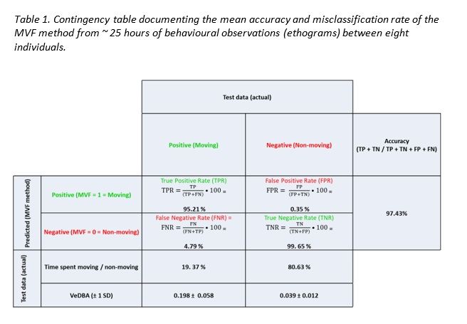
2. Methods
The procedure relates to 14 days of data derived from 11 wild lions (5 males and 6 females) in the
Kgalagadi Transfrontier Park, South Africa, during February-March 2019. Lions were equipped with a
LiteTrack GPS collar (Lotek Wireless Inc. [67]), to which a Gypsy_5 Techno-smart GPS unit (Technosmart
s.r.l. [68]) set to record at 1 Hz and a ‘Daily Diary’ (DD) [containing inter alia tri-axial accelerometers and
tri-axial magnetometers] [cf. 69] recording at 40 Hz, were attached. The GPS units were encased in a thick
3D-printed Acrylonitrile butadiene styrene (ABS) plastic oval housing and DD’s were enclosed in a water-
tight aluminium housing (cf. supplementary information (SI): Fig.1).

There were two collar sizes; small collars weighed 1.24 kg and large collars weighed 1.33 kg (attached
with all devices), which constituted < 2 % and < 1 % of the body mass of the lightest equipped female and
male animals, respectively. Data were retrieved from the collars approximately two weeks after the tag
deployment. Intermittent behavioural observations of each pride took place at dawn and dusk, and
occasionally during the day and night, for approximately 2-3 hours. During these periods, ethograms of
the collared individual’s various activities were recorded to document movement for comparison with the
acceleration and GPS speed estimates to verify the accuracy of our MVF thresholds (Table 1). These
observations were also carried to check for any potential negative side effects of the collars -none were
apparent. See SI.1 for more information on the study site, capture protocol and devices used). All
analyses were performed in Daily Diary Multi Trace (DDMT) [70], RStudio (open-source statistical
programming software, [71]) and Origin pro 2016 (OriginLab Corporation, [72]).

2.1 The Movement Verified Filtering (MVF) method

The MVF protocol (illustrated in Fig. 1) primarily involves deriving DBA from tri-axial accelerometery data,
computing speed from GPS data, and evaluating how both scale with each other during traveling
movement. Specifically, the step-by-step method (used for lions) involves:

1. Derivation of DBA

Vectorial dynamic body acceleration (VeDBA) [73] was the DBA metric used for activity [63] and as a
proxy for speed [64]. VeDBA is the vectorial sum of the dynamic body acceleration in a tri-axial
acceleration signal (cf. SI. 2). A rolling mean was applied to raw VeDBA values (a 2 s centre-aligned
window was used for lions) to ensure that both acceleration and deceleration components of an animal’s
stride cycle were incorporated together within any particular time period [63].

2. Derivation of GPS speed

The trigonometric Haversine formula [74, 75] was used to calculate the shortest distance between fixes of
an appropriate stepping range (cf. SI. 2). We define a stepping range as the interval between each
retained fix - a 5-fix stepping range was used for lions (distance computed between every 5th fix). Each
successive distance estimate was divided by its time period (between retained fixes) to convert to GPS

                                                   Page 6/28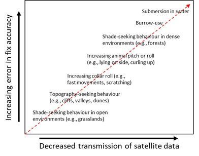
speed (m/s). A rolling mean was applied to GPS speed, (5 s centre-aligned rolling mean used for lions) for
greater interpolation purposes with respect to acceleration estimates (cf. discussion and SI. 2, detailing
the importance of a suitable stepping/post-smoothing range). Missing fixes were not included in the
computation of GPS speed.

3. Time synchronising GPS speed and DBA data

Both VeDBA and GPS speed data were time-synchronised and sub-sampled to 1 Hz to make the data
more manageable for analysis and because differentiating between fine-scale behaviours was not a
prime objective of this study. Missing locational data were expressed as ‘NA’.

4. Using GPS-derived distance to identify extreme outliers – Distance threshold (Z)

Missing locational data were replaced with values of the subsequent registered fix (RF). To identify
extreme outliers, a median rolling filter was applied to both the longitude and latitude coordinates of the
RF (MeFF). The Haversine method was then used to calculate the distance (units in metres) between the
two sets of coordinates (RF vs MeFF) per unit time. Locational data (RF) above the Z threshold were
deemed outliers (and thus failed the first step of the MVF protocol). By applying a rolling median using a
suitable window length, large distance estimates reflecting either a single or multiple ‘batched’ outlier(s)
could be distinguished from fixes deemed ‘accurate’ but highly separated in space due to large gaps in
locational data. The window length size and Z threshold should be chosen according to the animal in
question due to the scales of movement undertaken by different species (median filter window length of
60 s and a lenient threshold of 100 m used for lions). The window length should be large enough so that
the calculated median is not affected by a potential batch of consecutive anomalies at any one time.
When plotted against time, the distance between RF vs MeFF shows relatively consistent variation about
a given range (dependent on the window size set), though large obvious spikes indicate outliers, and the
extent of this disparity can give an indication of the Z threshold to set.

5. Movement thresholds (X & Y)

The second stage for screening the GPS data were the thresholds of VeDBA (XVeDBA) and GPS speed
(YGPS) that infer moving behaviour. We set the protocol for fixes to fail the MVF protocol when;

(i) VeDBA < X & GPS speed > Y (likely resultant from locational error)

(ii) VeDBA > X & GPS speed < Y (likely resultant from a stationary behaviour)

Where X and Y were given defined thresholds.

For the lions, after initial inspection of data with respect to ground-truthed behavioural observations, the
threshold X was determined as 0.11 g and the threshold Y was determined as 0.35 m/s (see below).
These thresholds were lenient, incorporating even slow movement and accounting for discrepancies of
the relative magnitude of acceleration estimates between individuals [cf. 63, 76].

                                                   Page 7/28
6. Time threshold (T)
The final stage of validating movement was to implement a minimum time threshold (T), over which
uninterrupted movement had to occur before it was classified as such. This was implemented to discern
travelling movement (where the animal location changed) from non-travelling movement (e.g., when the
animal rolled over) for periods when both XVeDBA and YGPS thresholds were met. MVF values were
assigned a value of one, for every GPS fix that was time-matched to periods where the above thresholds
(XVeDBA and YGPS) were met for a minimum duration of T (5 s was used for lions in the current study).
MVF periods encoded as 1, occurring ≤ 2 s from one another were merged). An MVF value of zero
represented either missing locational data, extreme outliers (identified by Z threshold) or periods when the
data indicated the animal was non-moving.
2.2 Data analyses
Various movement-derived metrics were compared between periods when animals were deemed to be
moving (‘travelling’ movement) (MVF = 1) and periods when they were deemed to be non-moving ('non-
travelling’/stationary movement) (MVF = 0). Such metrics include estimates of pitch, roll, heading,
distance travelled, speed and tortuosity estimates (see SI. 4 for procedures and references therein). Here,
unless otherwise stated, data ascribed as non-moving do not include data when GPS positions were
missing or were extreme outliers (the latter, determined by the z threshold as described above). Results
presented as percentages are given as ‘x’ with variance as one standard deviation (SD) and range in the
format; [ ± 1 SD (rangemin - rangemax)].
3. Results
Across 25 hours of behavioural observations, the MVF method using the thresholds outlined above
registered an average accuracy of 97 % (Table. 1; data correctly assigned as moving). This protocol was
determined to have a high true negative rate (> 99 %) and low false positive rate (< 1 %), indicating that
data that surpassed the MVF protocol indeed showed that the animal was moving with a high degree of
certainty. True positive rate was slightly lower (c. 95 %) and was perceived to have been primarily
modulated according to the variability in fix latency, which (irrespective of stepping/post-smoothing
range) can result in a time delay, uncoupling estimates of GPS speed from the instantaneous and
definitive expression of DBA estimates. It thus occasionally results in the beginning or end of periods that
animals were moving being misclassified as ‘non-moving’ (MVF = 0).
Page 8/28Fix success rate for the GPS varied between 89% and 97% across different animals. There was no
indication of systematic drop-out (variability of fix success rate) being modulated according to time over
the 14-day monitoring periods (SI. 3: Table S1 & Fig. S1). Generally, GPS-derived speed correlated well
with VeDBA ( r2 = 0.74 ± 0.04 (0.67 – 0.81)) (SI. 2: Fig. S4), especially during periods that were defined by
the MVF protocol as ‘movement’ (Fig. 3A & C, SI. 2: Fig. S1:3). Discrepancies between GPS-speed and
VeDBA were associated with location error (Fig. 2, SI. 2: Fig. S3), with the MVF approach highlighting that
the position of the collar depended on the animal’s behaviour (Fig. 4, SI. 3: Table S2) and that this was a
prime modulator of GPS performance (cf. Fig. 2, Fig. 3B, SI. 2: Fig. S3).
On average, 13.3% ± 3.3 (8.3 - 19.5) of data acquisition passed the MVF protocol (SI. 3: Table 2). The
majority of data deemed to be non-moving, was due to both XVeDBA and YGPS thresholds not being met;
70.4% ± 3.6 (65 – 77). However, an appreciable proportion of non-moving data was due to the YGPS
threshold being met, but not the XVeDBA being met; 12.4% ± 3.0 (9 – 18) or both YGPS and XVeDBA
thresholds being met, but not for the duration of Ttime; 12.5% ± 2.9 (8 – 18). Data where XVeDBA was met,
but not YGPS, comprised 4.85% ± 1.3 (3 - 7) (SI. 3: Fig. S2). The additive nature of errors associated with
GPS jitter was significant and exemplified within cumulative distances moved (between fixes) (Fig. 5, SI.
3: Table S2) and apparent even at the broadest scales of movement (SI.2: Fig. S5). It was clear that GPS
jitter was much more prominent when lions were resting and unless these data were filtered, use of these
raw unfiltered GPS data resulted in biased and erroneous speed, distance and tortuosity of movement
Page 9/28estimates (SI. 3: Table S2). Following the MVF method, there appeared to be a greater correlation between
DD- and GPS-derived heading estimates (SI. 4: Fig. S1).
4. Discussion
4.1 Evaluation of the MVF protocol
This work demonstrates the value of using both DBA and GPS data to discern moving behaviours from
stationary behaviours with a computationally quick protocol which effectively filters inaccurate fixes from
high frequency GPS data (e.g., ≥ 1 Hz, though possibly lower - cf. SI.2: Fig. S1 & S2). The central premise
is that when the magnitude of GPS speed and VeDBA both indicate movement (via pre-set thresholds),
then movement is indeed likely (Table. 1, Fig. 2, Fig. 3A, SI.2: Fig S1 & S3). This highlights the problem of
GPS jitter when VeDBA does not correspond to movement even though the GPS indicates otherwise.
Conversely, (relatively energetic) non-travelling behaviours are flagged up when the magnitude of VeDBA
infers movement while data of GPS speed does not.
Results reaffirm the importance of screening GPS inaccuracies within high frequency independently-
collected datasets of animal movements, due to the additive nature of GPS jitter - most prevalent during
rest periods (Fig. 2, SI. 3: Table S2 & Fig. S3). This was particularly relevant in the current study because
of the high proportion of data allocated to non-moving behaviours (SI.3: Table S2) (reflecting the energy-
conservation strategy that Kalahari lions adopt [cf. 77]). Indices of collar/postural offsets (evaluated
using absolute values of pitch and roll) showed high variability during times when GPS units did not
acquire fixes (Fig. 4), even when fix success rate could not be attributed to battery longevity (SI.3: Table
S1, Fig. S1). Animal behaviour (including habitat selection) thus seems to be a primary factor affecting
fix success rate and quality. Clear mono-modal peaks in the indices of posture were only witnessed when
all thresholds of our MVF approach were met (Fig. 4). Whilst there were slight differences in the tightness
of these distributions between lions (presumably due to discrepancies between collar fit), this does
suggest that the optimum collar-body position for acquiring satellite signals occurred during travelling
movement. In contrast, distributions were much more varied during times of non-moving, again
highlighting the interplay between animal behaviour, collar orientation and GPS performance.
Our results highlight how, in the absence of appropriate filtering, inappropriate conclusions about a
species’ movement can be made. Here, there were stark contrasts of tortuosity, speed and most notably,
distance travelled estimates between sets of data that both passed and failed our MVF method (SI. 3:
Table S2). This method may therefore have particular value for distinguishing true small-scale area-
restricted search (ARS) behaviour [78] by removing spurious turn angles caused by jitter [79, 80] (cf. SI.4:
Fig. S1). Here, cumulative distance from non-moving data was 80 % higher than their actual moving
periods for some lions and this highly inflated index of movement was exemplified when measured as
hourly averages (Fig. 5), apparently showing that lions travelled greater distances during the hottest parts
of the day, something that is extremely unlikely [cf. 81]. Furthermore, our MVF protocol reduced the
apparent maximum speed of any lion from >150 to 48 km/h. This critical issue highlights the drawbacks
Page 10/28of assessing GPS data sampled at high frequency (in spite of necessary post-resampling strategies
(SI.2)), which intensifies erroneous location estimates (cf. Fig. 2, SI.2: Fig. S3), even at macro-scales of
movement (SI.2: Fig. S4).
4.2 Utility of the MVF protocol according to species-specific and environmental circumstance
The Haversine method for determination of animal speed and location using GPS positional fixes can
estimate distances travelled with high precision, however for datasets containing many points collected
at high frequencies, distance estimates are unreliable at small stepping ranges due to the interplay
between location error and the precision of longitude and latitude coordinates that produce additive
errors [26, 82]. Most commercial GPS units record fixes to five decimal places, with the fifth digit of the
decimal place giving approximately 1.1 m resolution. Further, the computation time for a device to record
a GPS fix can vary, reducing the synchronisation of time between both GPS and the accelerometer logger.
Given that many terrestrial animals maintain relatively low travel speeds for extended periods [cf. 83], we
note that appropriate choice of stepping range and smoothing window are critical for deducing
reasonable step length estimates per unit time (SI.2: Fig. S1 & S2), with this being dependent upon the
(species-specific) scales of movement being assessed [cf. 64, 84].
Essentially, there is a trade-off between incorporating higher rates of error and increasing the lag of
change relative to the properly time-synchronized acceleration data. This means that accurate fine-scale
estimates of GPS-derived speed are not possible and so the relationship with body movement
measurements such as VeDBA will never be succinct given the disparity of resolution from both
measures. In addition, inter- and intra-specific variations of acceleration estimates can arise due to
discrepancies of; morphology [64], locomotion mechanisms (e.g., change in gait to facilitate higher
speeds [85]), extrinsic factors (e.g., moving over a deformable substrate / changeable grade [84, 86]), tag
placement [63] and collar roll [87, 88], thereby altering the relationship between VeDBA and mechanical
power (and thus speed) [84, 89].
Alongside GPS resampling, MVF user-defined thresholds are expected to change according to the study
species and scales of movement in question. For example, DBA estimates (specifically ODBA [63]) of
African elephants (Loxodonta africana) typically ranged between 0.15 and 0.3 g during periods
of walking [90] and this is comparable to that reported from Eurasian beavers (Castor fiber)
(0.265 ± 0.029) [91], though notably, both species have different leg lengths and move with very different
gaits which gives very different DBA-dependent speed estimates, as demonstrated by Bidder et al. [64] for
multiple species.
It is notable here that we have focussed on terrestrial movement, and this is primarily because the
relationship between DBA and speed can break down substantially for many aquatic and aerial species.
This occurs because, for example, birds can glide at a variety of grounds speeds (depending on e.g., wind
vectors and glide angle) without changing DBA, and air compression with depth affects the buoyancy of
many marine animals, which complicates the DBA~speed relationship depending on swim angle [92-94].
Furthermore, GPS is restricted to (potentially infrequent) resurfacing events for diving animals and so
Page 11/28scaling DBA with GPS-derived speed is problematic for extended periods of time during underwater
movements. Taken together, whilst we do not rule out extensions of the MVF method for use in such
environments, we advocate that in its current form, it is most suitable for evaluating movements on land.
Importantly, the validity of this method is dependent on the interaction between a focal species’ behaviour
and where it inhabits - the critical limitation being the assumption that fixes are accurate during periods
of moving. This is demonstrably not always the case (cf. Fig. 6), even in our study area, the Kgalagadi
Transfrontier Park, which is open, with relatively sparse vegetation. Since vegetation type and density are
key modulators of GPS accuracy [35, 38, 39, 43, 48], the viability of our method needs to be tested within
other (e.g., more vegetated) environments.
Nevertheless, for the study species in question, we have highlighted the effectiveness of this method and,
in line with the above considerations, have demonstrated that a general correlation does exist between
the magnitudes of both DBA and GPS speed during movement periods (Fig. 3, SI.2: Fig. S1:3). As such,
we suggest that this approach could be used further to discern reliable events of high performance (e.g.,
hunt chases) and implemented within the dead-reckoning framework [cf. 65, 95], both as a corollary to
the DBA-speed relationship (required for the speed coefficient) [65] and the GPS screening protocol prior
to the correction process of dead-reckoned tracks [66]. At the very least, we demonstrate the utility for
GPS speed to be included as a useful parameter for identifying behaviours and may be of value to more
complex approaches (e.g., machine learning [cf. 96, 97-99], the lowest common denominator (LoCoD)
method [100]) and space-state models [e.g., 101, 102] for precluding certain behaviours from movement
and screening for location error. Indeed, applying this method as a validator of movement extent within
behaviour-based studies over finely resolved space and time, may facilitate the powers of inference, such
as when considering animal responses to human barriers [cf. 103]. Lastly, we theorise that high fix
frequency will help elucidate fix inaccuracy within areas of high canopy cover, possibly via extensions to
this method such as including upper threshold limits and comparing variation in GPS speed juxtaposed
to DBA estimates and GPS- and DD-derived heading estimates (cf. SI. 4).
5. Conclusion
Here we reaffirm the importance of initial GPS screening so to avoid inaccurate movement estimates.
Animal behaviour seems to be a major modulator of GPS performance and this is particularly germane in
collared species due to the interaction between behaviour and collar orientation. The proposed Movement
Verified Filtering method provides a basis for high-resolution GPS-screening, which is user-friendly,
computationally quick and focuses on identifying behaviour to filter GPS data. Movement-defined
thresholds can be modelled according to the focal species in question, whilst further differences between
motion sensor and GPS derivatives can be incorporated into this MVF foundation to resolve fix
inaccuracy during movement. Movement-based outputs comparing MVF values from lion data,
exemplified the degree of inaccuracy associated with GPS jitter and the importance of removing such
additive error prior to assessing fine-scale trends of movement, particularly step length. Our results show
that consideration of data from both GPS units and motion sensors greatly helps validate true movement
Page 12/28patterns and reaffirms the caution required when interpreting fine-scale GPS sampling such as during
ARS analysis. Further work could assess the value of MVF for other species with different activities and
habitat selections, particularly those that move within highly vegetated areas. The consequences of the
errors introduced by GPS inaccuracies are broad, ranging from erroneous inferences of behaviour,
movement, speed and energy budgets. The approach proposed here avoids these errors and enables
accurate assessments of these traits.
Declarations
Ethics approval and consent to participate
Conditions and approvals were granted by the Animals Scientific Procedures Act (ASPA) at Queens
University of Belfast (QUB-BS-AREC-18-006) and Pretoria University (NAS061-19), permit authorisation
was given by South African National Parks (Permit Number SCAM 1550).
Consent for publication
Not applicable
Availability of data and materials
We provide a step-by step R script for implementing the MVF method on an example lion dataset
(containing DD and GPS data files). The R script and example data set will be made available on
GitHub [available at 104] if the manuscript is accepted for publication.
Competing interests
The authors declare that they have no competing interests
Funding
This research contributes to the CAASE project funded by King Abdullah University of Science and
Technology (KAUST) under the KAUST Sensor Initiative. Fieldwork was supported in part by a Department
for Economy Global Challenges Research Fund grant to MS.
Author Contributions
RMG conceived the study and RMG and RW wrote the initial draft. PH constructed tag housings.
Data collection (capture of lions for fitting and removal of technology) was led by SF, DG, PV, LVS and AB,
with assistance from MS, SB, MCVR, RMG, MB, CJT and PH. RMG conducted the analysis and all authors
contributed to manuscript revision.
Acknowledgments
Page 13/28We thank SANParks and the Department of Wildlife and National Parks, Botswana, for allowing our
research in the Kgalagadi Transfrontier Park We are grateful for support and kind assistance of the staff
and Rangers at the Kgalagadi National Park who were involved with this work, especially Steven Smith,
Christa von Elling, Wayne Oppel and Corera Links.
References
1. Nathan R, Getz WM, Revilla E, Holyoak M, Kadmon R, Saltz D, Smouse PE: A movement ecology
paradigm for unifying organismal movement research. Proceedings of the National Academy of
Sciences 2008, 105(49):19052-19059.
2. Cagnacci F, Boitani L, Powell RA, Boyce MS: Animal ecology meets GPS-based radiotelemetry: a
perfect storm of opportunities and challenges. Philosophical Transactions of the Royal Society B:
Biological Sciences 2010, 365(1550):2157-2162.
3. Latham ADM, Latham MC, Anderson DP, Cruz J, Herries D, Hebblewhite M: The GPS craze: six
questions to address before deciding to deploy GPS technology on wildlife. New Zealand Journal of
Ecology 2015, 39(1):143-152.
4. Hofman MPG, Hayward MW, Heim M, Marchand P, Rolandsen CM, Mattisson J, Urbano F, Heurich
M, Mysterud A, Melzheimer J, Morellet N, Voigt U, Allen BL, Gehr B, Rouco C, Ullmann W, Holand Ø,
Jørgensen NH, Steinheim G, Cagnacci F, Kroeschel M, Kaczensky P, Buuveibaatar B, Payne JC, Palmegiani
I, Jerina K, Kjellander P, Johansson Ö, LaPoint S, Bayrakcismith R, Linnell JDC, Zaccaroni M, Jorge MLS,
Oshima JEF, Songhurst A, Fischer C, Mc Bride RT, Jr., Thompson JJ, Streif S, Sandfort R, Bonenfant C,
Drouilly M, Klapproth M, Zinner D, Yarnell R, Stronza A, Wilmott L, Meisingset E, Thaker M, Vanak AT,
Nicoloso S, Graeber R, Said S, Boudreau MR, Devlin A, Hoogesteijn R, May-Junior JA, Nifong JC, Odden J,
Quigley HB, Tortato F, Parker DM, Caso A, Perrine J, Tellaeche C, Zieba F, Zwijacz-Kozica T, Appel CL,
Axsom I, Bean WT, Cristescu B, Périquet S, Teichman KJ, Karpanty S, Licoppe A, Menges V, Black K,
Scheppers TL, Schai-Braun SC, Azevedo FC, Lemos FG, Payne A, Swanepoel LH, Weckworth BV, Berger A,
Bertassoni A, McCulloch G, Šustr P, Athreya V, Bockmuhl D, Casaer J, Ekori A, Melovski D, Richard-Hansen
C, van de Vyver D, Reyna-Hurtado R, Robardet E, Selva N, Sergiel A, Farhadinia MS, Sunde P, Portas R,
Ambarli H, Berzins R, Kappeler PM, Mann GK, Pyritz L, Bissett C, Grant T, Steinmetz R, Swedell L, Welch
RJ, Armenteras D, Bidder OR, González TM, Rosenblatt A, Kachel S, Balkenhol N: Right on track?
Performance of satellite telemetry in terrestrial wildlife research. PLOS ONE 2019, 14(5):e0216223.
5. Dore KM, Hansen MF, Klegarth AR, Fichtel C, Koch F, Springer A, Kappeler P, Parga JA, Humle T,
Colin C, Raballand E, Huang Z-P, Qi X-G, Di Fiore A, Link A, Stevenson PR, Stark DJ, Tan N, Gallagher CA,
Anderson CJ, Campbell CJ, Kenyon M, Pebsworth P, Sprague D, Jones-Engel L, Fuentes A: Review of GPS
collar deployments and performance on nonhuman primates. Primates 2020, 61(3):1-15.
6. Pfeiffer T, Meyburg B-U: GPS tracking of Red Kites (Milvus milvus) reveals fledgling number is
negatively correlated with home range size. Journal of Ornithology 2015, 156(4):963-975.
Page 14/287. Christiansen F, Esteban N, Mortimer JA, Dujon AM, Hays GC: Diel and seasonal patterns in
activity and home range size of green turtles on their foraging grounds revealed by extended Fastloc-GPS
tracking. Marine Biology 2016, 164(1):10.
8. Galanti V, Tosi G, Rossi R, Foley C: The use of GPS radio-collars to track elephants
(Loxodonta africana) in the Tarangire National Park (Tanzania). Hystrix, the Italian Journal of
Mammalogy 2000, 11(2).
9. García‐Ripollés C, López‐López P, Urios V: First description of migration and wintering of adult
Egyptian Vultures Neophron percnopterus tracked by GPS satellite telemetry. Bird Study 2010, 57(2):261-
265.
10. Yamaç E, Bilgin CC: Post-fledging movements of Cinereous Vultures Aegypius monachus in
Turkey revealed by GPS telemetry. Ardea 2012, 100(2):149-156.
11. Skarin A, Danell Ö, Bergström R, Moen J: Summer habitat preferences of GPS-collared reindeer
Rangifer tarandus tarandus. Wildlife Biology 2008, 14(1):1-15.
12. Nielson RM, Manly BFJ, McDonald LL, Sawyer H, McDonald TL: Estimating habitat selection
when GPS fix success is less than 100%. Ecology 2009, 90(10):2956-2962.
13. Rumble MA, Benkobi L, Lindzey F, Gamo RS: Evaluating elk habitat interactions with GPS collars.
In: Tracking animals with GPS: 12-13 March 2001 2001; Macaulay Land Use Research Institute, Aberdeen,
UK: Macaulay Institute. 11-17.
14. McDuie F, Casazza ML, Overton CT, Herzog MP, Hartman CA, Peterson SH, Feldheim CL,
Ackerman JT: GPS tracking data reveals daily spatio-temporal movement patterns of waterfowl.
Movement Ecology 2019, 7(1):6.
15. Ungar ED, Henkin Z, Gutman M, Dolev A, Genizi A, Ganskopp D: Inference of animal activity from
GPS collar data on free-ranging cattle. Rangeland Ecology & Management 2005, 58(3):256-266.
16. Owen‐Smith N, Goodall V: Coping with savanna seasonality: comparative daily activity patterns
of African ungulates as revealed by GPS telemetry. Journal of Zoology 2014, 293(3):181-191.
17. Cristescu B, Stenhouse GB, Boyce MS: Predicting multiple behaviors from GPS radiocollar cluster
data. Behavioral Ecology 2015, 26(2):452-464.
18. Hacker CE, Horback KM, Miller LJ: GPS technology as a proxy tool for determining relationships
in social animals: An example with African elephants. Applied Animal Behaviour Science 2015, 163:175-
182.
19. Recio MR, Mathieu R, Latham MC, Latham ADM, Seddon PJ: Quantifying fine-scale resource
selection by introduced European hedgehogs (Erinaceus europaeus) in ecologically sensitive areas.
Page 15/28Biological Invasions 2013, 15(8):1807-1818.
20. Liu D, Zhang G, Jiang H, Chen L, Meng D, Lu J: Seasonal dispersal and longitudinal migration in
the Relict Gull Larus relictus across the Inner-Mongolian Plateau. PeerJ 2017, 5:e3380.
21. Hallworth MT, Marra PP: Miniaturized GPS Tags Identify Non-breeding Territories of a Small
Breeding Migratory Songbird. Scientific Reports 2015, 5(1):11069.
22. Gibb R, Shoji A, Fayet AL, Perrins CM, Guilford T, Freeman R: Remotely sensed wind speed
predicts soaring behaviour in a wide-ranging pelagic seabird. Journal of The Royal Society
Interface 2017, 14(132):20170262.
23. Blecha KA, Alldredge MW: Improvements on GPS Location Cluster Analysis for the Prediction of
Large Carnivore Feeding Activities: Ground-Truth Detection Probability and Inclusion of Activity Sensor
Measures. PLOS ONE 2015, 10(9):e0138915.
24. de Weerd N, van Langevelde F, van Oeveren H, Nolet BA, Kölzsch A, Prins HHT, de Boer WF:
Deriving Animal Behaviour from High-Frequency GPS: Tracking Cows in Open and Forested Habitat. PLOS
ONE 2015, 10(6):e0129030.
25. Wang Y, Nickel B, Rutishauser M, Bryce CM, Williams TM, Elkaim G, Wilmers CC: Movement,
resting, and attack behaviors of wild pumas are revealed by tri-axial accelerometer measurements.
Movement ecology 2015, 3(1):1-12.
26. Ryan PG, Petersen SL, Peters G, Grémillet D: GPS tracking a marine predator: the effects of
precision, resolution and sampling rate on foraging tracks of African Penguins. Marine Biology 2004,
145(2):215-223.
27. Humphries NE, Weimerskirch H, Sims DW: A new approach for objective identification of turns
and steps in organism movement data relevant to random walk modelling. Methods in Ecology and
Evolution 2013, 4(10):930-938.
28. Edelhoff H, Signer J, Balkenhol N: Path segmentation for beginners: an overview of current
methods for detecting changes in animal movement patterns. Movement Ecology 2016, 4(1):21.
29. Janeau G, Adrados C, Joachim J, Gendner J-P, Pépin D: Performance of differential GPS collars
in temperate mountain forest. Comptes Rendus Biologies 2004, 327(12):1143-1149.
30. Swanepoel LH, Dalerum F, Van Hoven W: Factors affecting location failure of GPS collars fitted
to African leopards (Panthera pardus). African Journal of Wildlife Research 2010, 40(1):10-15.
31. Smith BJ, Hart KM, Mazzotti FJ, Basille M, Romagosa CM: Evaluating GPS biologging
technology for studying spatial ecology of large constricting snakes. Animal Biotelemetry 2018, 6(1):1.
Page 16/2832. Cochrane MM, Brown DJ, Moen RA: GPS Technology for Semi-Aquatic Turtle Research.
Diversity 2019, 11(3):34.
33. Cain JW, Krausman PR, Jansen BD, Morgart JR: Influence of topography and GPS fix interval on
GPS collar performance. Wildlife Society Bulletin 2005, 33(3):926-934.
34. Ironside KE, Mattson DJ, Arundel TR, Hansen JR: Is GPS telemetry location error screening
beneficial? Wildlife Biology 2017, 2017(17).
35. Adams AL, Dickinson KJM, Robertson BC, van Heezik Y: An Evaluation of the Accuracy and
Performance of Lightweight GPS Collars in a Suburban Environment. PLOS ONE 2013, 8(7):e68496.
36. Quaglietta L, Martins BH, de Jongh A, Mira A, Boitani L: A Low-Cost GPS GSM/GPRS Telemetry
System: Performance in Stationary Field Tests and Preliminary Data on Wild Otters (Lutra lutra). PLOS
ONE 2012, 7(1):e29235.
37. Justicia LS, Rosell F, Mayer M: Performance of GPS units for deployment on semiaquatic
animals. PLOS ONE 2018, 13(12):e0207938.
38. Heard DC, Ciarniello LM, Seip DR: Grizzly Bear Behavior and Global Positioning System Collar Fix
Rates. The Journal of Wildlife Management 2008, 72(3):596-602.
39. Hansen MC, Riggs RA: Accuracy, Precision, and Observation Rates of Global Positioning System
Telemetry Collars. The Journal of Wildlife Management 2008, 72(2):518-526.
40. D'eon RG, Delparte D: Effects of radio-collar position and orientation on GPS radio-collar
performance, and the implications of PDOP in data screening. Journal of Applied Ecology 2005,
42(2):383-388.
41. Forin-Wiart M-A, Hubert P, Sirguey P, Poulle M-L: Performance and Accuracy of Lightweight and
Low-Cost GPS Data Loggers According to Antenna Positions, Fix Intervals, Habitats and Animal
Movements. PLOS ONE 2015, 10(6):e0129271.
42. McGavin SL, Bishop-Hurley GJ, Charmley E, Greenwood PL, Callaghan MJ: Effect of GPS sample
interval and paddock size on estimates of distance travelled by grazing cattle in rangeland, Australia. The
Rangeland Journal 2018, 40(1):55-64.
43. Lewis JS, Rachlow JL, Garton EO, Vierling LA: Effects of habitat on GPS collar performance:
using data screening to reduce location error. Journal of Applied Ecology 2007, 44(3):663-671.
44. Vance JA, Jachowski DS, Boynton AC, Kelly MJ: Importance of evaluating GPS telemetry collar
performance in monitoring reintroduced populations. Wildlife Society Bulletin 2017, 41(4):729-735.
Page 17/2845. Dussault C, Courtois R, Ouellet J-P, Huot J: Influence of Satellite Geometry and Differential
Correction on GPS Location Accuracy. Wildlife Society Bulletin (1973-2006) 2001, 29(1):171-179.
46. Ganskopp DC, Johnson DD: GPS Error in Studies Addressing Animal Movements and Activities.
Rangeland Ecology & Management 2007, 60(4):350-358.
47. Bjørneraas K, Van Moorter B, Rolandsen CM, Herfindal I: Screening Global Positioning System
Location Data for Errors Using Animal Movement Characteristics. The Journal of Wildlife
Management 2010, 74(6):1361-1366.
48. Frair JL, Fieberg J, Hebblewhite M, Cagnacci F, DeCesare NJ, Pedrotti L: Resolving issues of
imprecise and habitat-biased locations in ecological analyses using GPS telemetry data. Philosophical
Transactions of the Royal Society B: Biological Sciences 2010, 365(1550):2187-2200.
49. Jiang Z, Sugita M, Kitahara M, Takatsuki S, Goto T, Yoshida Y: Effects of habitat feature,
antenna position, movement, and fix interval on GPS radio collar performance in Mount Fuji, central
Japan. Ecological Research 2008, 23(3):581-588.
50. Mattisson J, Andrén H, Persson J, Segerström P: Effects of Species Behavior on Global
Positioning System Collar Fix Rates. The Journal of Wildlife Management 2010, 74(3):557-563.
51. Brown DD, LaPoint S, Kays R, Heidrich W, Kümmeth F, Wikelski M: Accelerometer-informed GPS
telemetry: Reducing the trade-off between resolution and longevity. Wildlife Society Bulletin 2012,
36(1):139-146.
52. Jung TS, Kuba K: Performance of GPS collars on free-ranging bison (Bison bison) in north-
western Canada. Wildlife Research 2015, 42(4):315-323.
53. Belant JL: Effects of Antenna Orientation and Vegetation on Global Positioning System
Telemetry Collar Performance. Northeastern Naturalist 2009, 16(4):577-584, 578.
54. Frair JL, Nielsen SE, Merrill EH, Lele SR, Boyce MS, Munro RHM, Stenhouse GB, Beyer HL:
Removing GPS collar bias in habitat selection studies. Journal of Applied Ecology 2004, 41(2):201-212.
55. Visscher DR: GPS measurement error and resource selection functions in a fragmented
landscape. Ecography 2006, 29(3):458-464.
56. Patel A, Stocks B, Fisher C, Nicolls F, Boje E: Tracking the Cheetah Tail Using Animal-Borne
Cameras, GPS, and an IMU. IEEE Sensors Letters 2017, 1(4):1-4.
57. Joo R, Boone ME, Clay TA, Patrick SC, Clusella‐Trullas S, Basille M: Navigating through the R
packages for movement. Journal of Animal Ecology 2020, 89(1):248-267.
Page 18/2858. Buerkert A, Schlecht E: Performance of three GPS collars to monitor goats’ grazing itineraries on
mountain pastures. computers and electronics in agriculture 2009, 65(1):85-92.
59. McGregor HW, Legge SM, Jones ME, Johnson CN: GPS collars are more efficient when collecting
high-frequency data. Australian Mammalogy 2016, 38(2):237-240.
60. Wilson AM, Lowe J, Roskilly K, Hudson PE, Golabek K, McNutt J: Locomotion dynamics of
hunting in wild cheetahs. Nature 2013, 498(7453):185-189.
61. Moriarty KM, Epps CW: Retained satellite information influences performance of GPS devices in
a forested ecosystem. Wildlife Society Bulletin 2015, 39(2):349-357.
62. Watanabe S, Izawa M, Kato A, Ropert-Coudert Y, Naito Y: A new technique for monitoring the
detailed behaviour of terrestrial animals: A case study with the domestic cat. Applied Animal Behaviour
Science 2005, 94(1):117-131.
63. Wilson RP, Börger L, Holton MD, Scantlebury DM, Gómez-Laich A, Quintana F, Rosell F, Graf PM,
Williams H, Gunner R, Hopkins L, Marks N, Geraldi NR, Duarte CM, Scott R, Strano MS, Robotka H,
Eizaguirre C, Fahlman A, Shepard ELC: Estimates for energy expenditure in free-living animals using
acceleration proxies: A reappraisal. Journal of Animal Ecology 2020, 89(1):161-172.
64. Bidder OR, Soresina M, Shepard ELC, Halsey LG, Quintana F, Gómez-Laich A, Wilson RP: The
need for speed: testing acceleration for estimating animal travel rates in terrestrial dead-reckoning
systems. Zoology 2012, 115(1):58-64.
65. Bidder OR, Walker JS, Jones MW, Holton MD, Urge P, Scantlebury DM, Marks NJ, Magowan EA,
Maguire IE, Wilson RP: Step by step: reconstruction of terrestrial animal movement paths by dead-
reckoning. Movement Ecology 2015, 3(1):23.
66. Dewhirst OP, Evans HK, Roskilly K, Harvey RJ, Hubel TY, Wilson AM: Improving the accuracy of
estimates of animal path and travel distance using GPS drift-corrected dead reckoning. Ecology and
Evolution 2016, 6(17):6210-6222.
67. Lotek products. Available at https://www.lotek.com/. Accessed 07 March 2021
68. Technosmart GPS tracking systems for animals. Available at https://www.technosmart.eu/.
Accessed 07 March 2021.
69. Wilson RP, Shepard E, Liebsch N: Prying into the intimate details of animal lives: use of a daily
diary on animals. Endangered Species Research 2008, 4(1-2):123-137.
70. Wildbyte Technologies. Available at http://www.wildbytetechnologies.com/. Accessed 07 March
2021.
Page 19/2871. The R Project for Statistical Computing. Available at https://www.r-project.org/. Accessed 07
March 2021.
72. Origin Pro Graphing & Analysis. Available a https://www.originlab.com/origin. Accessed 04 June
2021.
73. Qasem L, Cardew A, Wilson A, Griffiths I, Halsey LG, Shepard ELC, Gleiss AC, Wilson R: Tri-Axial
Dynamic Acceleration as a Proxy for Animal Energy Expenditure; Should We Be Summing Values or
Calculating the Vector? PLOS ONE 2012, 7(2):e31187.
74. Chopde NR, Nichat MK: Landmark based shortest path detection by using A* and Haversine
formula. International Journal of Innovative Research in Computer and Communication
Engineering 2013, 1(2):298-302.
75. Harja YD, Sarno R: Determine the best option for nearest medical services using Google maps
API, Haversine and TOPSIS algorithm. In: 2018 International Conference on Information and
Communications Technology (ICOIACT): 6-7 March 2018 2018. 814-819.
76. Williams HJ, Holton MD, Shepard ELC, Largey N, Norman B, Ryan PG, Duriez O, Scantlebury M,
Quintana F, Magowan EA, Marks NJ, Alagaili AN, Bennett NC, Wilson RP: Identification of animal
movement patterns using tri-axial magnetometry. Movement Ecology 2017, 5(1):6.
77. Hill RW, Wyse GA, Anderson M, Anderson M: Animal physiology, vol. 2. Sunderland, MA: Sinauer
Associates 2004.
78. Weimerskirch H, Pinaud D, Pawlowski F, Bost CA: Does Prey Capture Induce Area‐Restricted
Search? A Fine‐Scale Study Using GPS in a Marine Predator, the Wandering Albatross. The American
Naturalist 2007, 170(5):734-743.
79. Hurford A: GPS Measurement Error Gives Rise to Spurious 180° Turning Angles and Strong
Directional Biases in Animal Movement Data. PLOS ONE 2009, 4(5):e5632.
80. DeCesare NJ, Squires JR, Kolbe JA: Effect of forest canopy on GPS-based movement data.
Wildlife Society Bulletin 2005, 33(3):935-941.
81. Packer C, Swanson A, Ikanda D, Kushnir H: Fear of darkness, the full moon and the nocturnal
ecology of African lions. PLOS ONE 2011, 6(7):e22285.
82. Laube P, Purves RS: How fast is a cow? Cross-Scale Analysis of Movement Data. Transactions in
GIS 2011, 15(3):401-418.
83. Perry AK, Blickhan R, Biewener AA, Heglund NC, Taylor CR: Preferred speeds in terrestrial
vertebrates: are they equivalent? Journal of Experimental Biology 1988, 137(1):207-219.
Page 20/2884. Bidder OR, Qasem LA, Wilson RP: On Higher Ground: How Well Can Dynamic Body Acceleration
Determine Speed in Variable Terrain? PLOS ONE 2012, 7(11):e50556.
85. Halsey LG, Shepard ELC, Hulston CJ, Venables MC, White CR, Jeukendrup AE, Wilson RP:
Acceleration versus heart rate for estimating energy expenditure and speed during locomotion in animals:
Tests with an easy model species, Homo sapiens. Zoology 2008, 111(3):231-241.
86. Kerdok AE, Biewener AA, McMahon TA, Weyand PG, Herr HM: Energetics and mechanics of
human running on surfaces of different stiffnesses. Journal of Applied Physiology 2002, 92(2):469-478.
87. Silvy NJ, Lopez RR, Peterson MJ: Wildlife marking techniques. The Wildlife Society: Bethesda,
MD; 2005.
88. Shepard EL, Wilson RP, Halsey LG, Quintana F, Laich AG, Gleiss AC, Liebsch N, Myers AE, Norman
B: Derivation of body motion via appropriate smoothing of acceleration data. Aquatic Biology 2008,
4(3):235-241.
89. Gleiss AC, Wilson RP, Shepard ELC: Making overall dynamic body acceleration work: on the
theory of acceleration as a proxy for energy expenditure. Methods in Ecology and Evolution 2011, 2(1):23-
33.
90. Soltis J, King L, Vollrath F, Douglas-Hamilton I: Accelerometers and simple algorithms identify
activity budgets and body orientation in African elephants Loxodonta africana. Endangered Species
Research 2016, 31:1-12.
91. Graf PM, Wilson RP, Qasem L, Hackländer K, Rosell F: The Use of Acceleration to Code for Animal
Behaviours; A Case Study in Free-Ranging Eurasian Beavers Castor fiber. PLOS ONE 2015,
10(8):e0136751.
92. Wilson RP, Hustler K, Ryan PG, Burger AE, Noldeke EC: Diving birds in cold water: do Archimedes
and Boyle determine energetic costs? The American Naturalist 1992, 140(2):179-200.
93. Williams H, Shepard E, Duriez O, Lambertucci SA: Can accelerometry be used to distinguish
between flight types in soaring birds? Animal Biotelemetry 2015, 3(1):1-11.
94. Gunner RM, Holton MD, Scantlebury DM, Van Schalkwyk OL, English HM, Williams HJ, Hopkins P,
Quintana F, Gómez-Laich A, Börger L, Redcliffe J, Yoda K, Yamamoto T, Ferreira S, Govender D, Viljoen P,
Bruns A, Bell SH, Marks NJ, Bennett NC, Tonini MH, Duarte CM, Van Rooyen MC, Bertelsen MF, Tambling
CJ, Wilson RP: Dead-reckoning animal movements in R – A reappraisal using Gundog.Tracks. Animal
Biotelemetry (in press).
95. Walker JS, Jones MW, Laramee RS, Holton MD, Shepard ELC, Williams HJ, Scantlebury DM,
Marks NJ, Magowan EA, Maguire IE, Bidder OR, Di Virgilio A, Wilson RP: Prying into the intimate secrets of
Page 21/28animal lives; software beyond hardware for comprehensive annotation in ‘Daily Diary’ tags. Movement
Ecology 2015, 3(1):29.
96. Bidder OR, Campbell HA, Gómez-Laich A, Urgé P, Walker J, Cai Y, Gao L, Quintana F, Wilson RP:
Love Thy Neighbour: Automatic Animal Behavioural Classification of Acceleration Data Using the K-
Nearest Neighbour Algorithm. PLOS ONE 2014, 9(2):e88609.
97. Samarasinghe S: Neural Networks for Applied Sciences and Engineering: From Fundamentals to
Complex Pattern Recognition: CRC Press; 2016.
98. Fehlmann G, O’Riain MJ, Hopkins PW, O’Sullivan J, Holton MD, Shepard ELC, King AJ:
Identification of behaviours from accelerometer data in a wild social primate. Animal Biotelemetry 2017,
5(1):6.
99. Goodall VL, Ferreira SM, Funston PJ, Maruping-Mzileni N: Uncovering hidden states in African
lion movement data using hidden Markov models. Wildlife Research 2019, 46(4):296-303.
100. Wilson RP, Holton MD, di Virgilio A, Williams H, Shepard ELC, Lambertucci S, Quintana F, Sala JE,
Balaji B, Lee ES, Srivastava M, Scantlebury DM, Duarte CM: Give the machine a hand: A Boolean time-
based decision-tree template for rapidly finding animal behaviours in multisensor data. Methods in
Ecology and Evolution 2018, 9(11):2206-2215.
101. Fleming CH, Drescher-Lehman J, Noonan MJ, Akre TSB, Brown DJ, Cochrane MM, Dejid N,
DeNicola V, DePerno CS, Dunlop JN, Gould NP, Hollins J, Ishii H, Kaneko Y, Kays R, Killen SS, Koeck B,
Lambertucci SA, LaPoint SD, Medici EP, Meyburg B-U, Miller TA, Moen RA, Mueller T, Pfeiffer T, Pike KN,
Roulin A, Safi K, Séchaud R, Scharf AK, Shephard JM, Stabach JA, Stein K, Tonra CM, Yamazaki K, Fagan
WF, Calabrese JM: A comprehensive framework for handling location error in animal tracking data*.
bioRxiv 2020:2020.2006.2012.130195.
102. Jonsen ID, Patterson TA, Costa DP, Doherty PD, Godley BJ, Grecian WJ, Guinet C, Hoenner X,
Kienle SS, Robinson PW, Votier SC, Whiting S, Witt MJ, Hindell MA, Harcourt RG, McMahon CR: A
continuous-time state-space model for rapid quality control of argos locations from animal-borne tags.
Movement Ecology 2020, 8(1):31.
103. Jacobson SL, Bliss-Ketchum LL, de Rivera CE, Smith WP: A behavior-based framework for
assessing barrier effects to wildlife from vehicle traffic volume. Ecosphere 2016, 7(4):e01345.
104. Gundog.Tracks GitHub database. Available at https://github.com/Richard6195/Dead-reckoning-
animal-movements-in-R. Accessed 29 May 2021
Figures
Page 22/28You can also read