Defense Navigation Capabilities - TECHNOLOGY ASSESSMENT
←
→
Page content transcription
If your browser does not render page correctly, please read the page content below
United States Government Accountability Office

               Report to the Committee on Armed Services, U.S. Senate

May 2021       TECHNOLOGY ASSESSMENT

               Defense Navigation
               Capabilities
               DOD is Developing Positioning, Navigation, and
               Timing Technologies to Complement GPS

GAO-21-320SP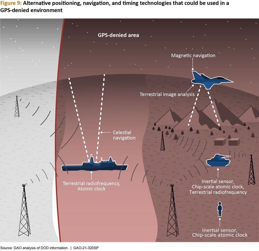
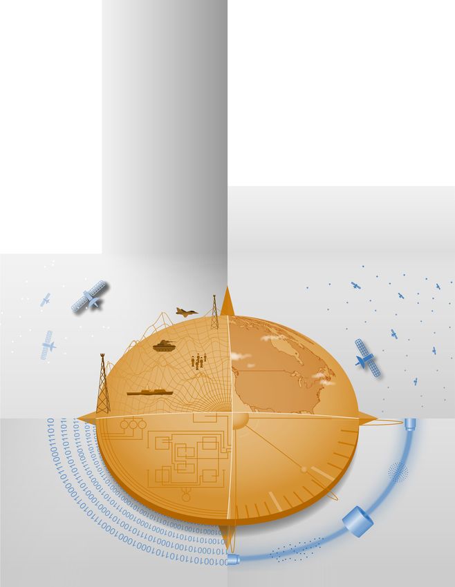
The cover image displays a compass with stylized representations of elements of positioning, navigation, and timing (PNT):
satellites orbiting Earth (upper-right); a clock face and an atomic fountain clock (lower-right); the electronics in PNT sensors and
electronic data provided by PNT hardware (lower-left); and various military platforms using different PNT technologies, such as
those based on the environment, radiofrequency signals, and satellites (upper-left). Source: GAO.
TECHNOLOGY ASSESSMENT

Highlights of GAO-21-320SP, a report to the
Committee on Armed Services, U.S. Senate
                                              Defense Navigation Capabilities
                                              DOD is Developing Positioning, Navigation,
May 2021
                                              and Timing Technologies to Complement GPS

 Why GAO did this study                       What GAO found
 For decades, the satellite-based GPS         The Department of Defense (DOD) plans to keep the Global Positioning System
 has transmitted PNT data to receivers        (GPS) at the core of its positioning, navigation, and timing (PNT) solution, using
 used by military platforms and               other PNT technology to complement GPS or as an alternative for when GPS is
 personnel worldwide. PNT                     degraded or unavailable. DOD’s alternative PNT science and technology portfolio
 information is essential in many             explores two approaches: improved sensors to provide relative PNT information,
 facets of DOD operations. Given the          and external sources to provide absolute positioning and navigation. Relative PNT
 ubiquity of GPS, the failure,                technologies include inertial sensors and clocks to allow a platform to track its
 malfunction, or jamming of its signals       position and keep track of time without an external signal like GPS. However,
 or equipment could disrupt military          relative PNT technologies require another PNT technology to correct errors that can
 activities involving aircraft, ships,        accumulate with such systems. Absolute PNT technologies allow a platform to use
 munitions, land vehicles, and ground         external sources of information to determine its position but rely on the availability
 troops. This possibility has led DOD to      of those external sources. Absolute PNT technologies include celestial and magnetic
 explore alternatives to GPS.                 navigation as well as the use of very low radiofrequencies or low Earth orbit
 GAO was asked to assess the
                                              satellites to transmit information.
 alternative PNT technologies DOD is          Technologies that could be used in GPS-denied environment
 developing. This report discusses (1)
 how DOD plans to meet future PNT
 needs and the capabilities and
 limitations of alternative PNT
 technologies, (2) how alternative PNT
 technologies integrate with one
 another and with current PNT
 capabilities, and (3) policy options
 that may help address challenges
 with the development and                     DOD may use multiple PNT technologies to provide sufficient PNT information to its
 integration of alternative PNT               various military platforms. DOD is pursuing approaches, such as creating common
 technologies.                                standards and interfaces, to aid in integrating and fielding new PNT technologies
 To address these objectives, GAO             faster and at lower cost. DOD is developing its PNT modeling and simulation
 reviewed technical studies, agency           capabilities to evaluate the performance of new PNT technologies.
 documents, and other key reports;            DOD faces challenges in developing and integrating alternative PNT technologies.
 interviewed government officials and         Officials from across DOD and experts told GAO that alternative PNT solutions are
 researchers about alternative PNT            not prioritized within DOD. For example, there is no central program office
 technologies; and convened a 3-day           responsible for developing the variety of alternative PNT technologies across DOD.
 meeting of experts from government,          DOD’s continued reliance on GPS, despite known GPS vulnerabilities to disruption,
 non-governmental organizations,              presents a challenge for obtaining sufficient support to develop viable alternatives.
 academia, and industry. GAO is               DOD officials and experts also said challenges in establishing clear PNT performance
 identifying policy options in this           requirements hinder technology development.
 report.
                                              GAO developed six policy options that may help address challenges with developing
                                              and integrating alternative PNT technologies. The policy options identify possible
                                              new actions by policymakers, who may include Congress, federal agencies, and
View GAO-21-320SP. For more information,      industry groups. See below for details of the policy options and relevant
contact Karen L. Howard at (202) 512-6888
or HowardK@gao.gov or Jon Ludwigson at        opportunities and considerations.
(202) 512-4841 or LudwigsonJ@gao.gov.
                                                                                                United States Government Accountability Office
Policy options that may help address challenges with developing and integrating alternative PNT technologies

                                                          Opportunities                                           Considerations
Increase Collaboration             •    Increased coordination could allow the military          •    PNT solutions for a particular mission or
Policymakers could consider             services to leverage one another’s research and               platform may still need significant
mechanisms to coordinate                development activities.                                       customization, possibly offsetting the
across DOD to clarify              •    Prioritization of alternative PNT could increase the          benefits from centralized coordination.
responsibilities and authorities        technology’s visibility, allowing more programs and      •    Current mechanisms, such as the PNT
in prioritizing the need for            platforms within DOD to better understand                     Oversight Council, may not have the
alternative PNT technologies.           available technologies.                                       capacity to take on alternative PNT
                                                                                                      coordination.
Focus on Resiliency                •    By focusing on resiliency, technologies that             •    A PNT solution will likely need multiple
Policymakers could consider             add to resilient PNT could receive higher                     technologies to meet full PNT
selecting the most resilient            priority for development, even if they are not                requirements, because no single
technologies as the                     full replacements for GPS.                                    alternative PNT technology is currently
cornerstone of the PNT suite                                                                          able to provide all of the required
for military missions, rather                                                                         information.
than defaulting to GPS.                                                                          •    DOD will need to continue maintaining
                                                                                                      GPS, as it will remain a part of the PNT
                                                                                                      solution.
Clarify Requirements               •    With performance requirements that better                •    GAO previously reported that creating
Policymakers could consider             reflect mission needs, DOD could make more                    requirements involves appropriately
opportunities for DOD to                informed decisions (such as savings in cost or                skilled personnel.
clarify what level of PNT               integration time) in developing viable                   •    Programs may still want GPS-level
performance is actually                 alternative technologies that will meet the                   performance because more precise PNT
needed for missions, rather             actual mission needs, but not necessarily have                information is always desired, even when
than defaulting to                      GPS-level performance.                                        it goes beyond what is needed to
requirements that match GPS                                                                           complete a specific mission.
performance.
Coordinate with Industry           •    DOD clearly communicating its needs to industry          •    Commercial industry may not be
Policymakers could                      could allow industry to be better positioned to               incentivized to develop and manufacture
consider ensuring that                  meet those needs.                                             alternative PNT technologies if the market
DOD and commercial                 •    Industry may have alternative PNT technologies                is too small.
industry coordinate so                  that could be applied to defense.                        •    A lack of transparency into proprietary
industry is prepared to                                                                               commercial technology may mask
meet DOD’s needs, and                                                                                 vulnerabilities of different PNT
DOD can leverage industry                                                                             technologies.
advances.
Institutionalize Open              •    With appropriate resources, DOD’s open                   •    The open architecture initiative will need
Architecture                            architecture initiative has the potential to greatly          buy-in across the military services, as well
Policymakers could                      reduce integration costs and time for all PNT                 as with commercial industry partners,
consider making the                     technologies.                                                 which may be difficult to achieve.
open architecture                  •    Open architecture could keep DOD ahead of                •    Once implemented, the open architecture
initiative more                         evolving threats to PNT, as it would be easier to             initiative could need continued resources
permanent, including                    field new alternative PNT technologies.                       and governance, as the architecture will
providing funding.                                                                                    likely evolve.
Analyze Vulnerabilities            •    Given that a future solution will likely require a PNT   •    The complexity of having a unique PNT
Policymakers could consider             system comprised of a combination of different                system for each mission and platform
having DOD conduct ongoing              technologies, users could be better informed about            could make this analysis difficult.
analysis of vulnerabilities of          each combination’s overall vulnerabilities.              •    If DOD relies more on alternative PNT, the
different PNT systems.             •    Users could better match PNT solutions to the                 threats will evolve in response to that
                                        mission and threat.                                           strategy, which may mean the
                                                                                                      vulnerability analysis needs to be updated
                                                                                                      regularly.
Source: GAO. | GAO-21-320SP

                                                                                                 United States Government Accountability Office
Table of Contents
Introduction Letter.............................................................................................................. 1
1 Background ...................................................................................................................... 3
       1.1 Threats to GPS-supplied PNT information ......................................................................... 3
       1.2 Efforts to mitigate threats to GPS-supplied PNT ............................................................... 6
       1.3 PNT policies and related laws ............................................................................................ 6
2 DOD’s Future Plans Continue to Focus on Using GPS While Pursuing Several Alternative
PNT Technologies ................................................................................................................ 8
       2.1 DOD plans to keep GPS at the core of its PNT architecture, with alternate PNT sources
            providing complementary capabilities ........................................................................... 8
       2.2 Improved sensors can provide relative PNT information locally to platforms without
             GPS, but errors cause them to become less accurate over time ................................. 11
       2.3 Several methods using external sources show promise to provide absolute PNT
             information, but none can match the performance of GPS ......................................... 13
3 DOD Is Working to Integrate, Communicate, and Evaluate PNT Information from
Multiple Sources ............................................................................................................... 18
       3.1 DOD has established PNT science and technology initiatives to support PNT
            development ................................................................................................................ 18
       3.2 DOD is pursuing a modular open systems approach to integrate
            multiple PNT sources .................................................................................................... 18
       3.3 DOD is investigating methods to communicate and evaluate PNT information.............23
       3.4 DOD is developing a PNT modeling and simulation framework to evaluate potential
            performance and guide investment decisions ............................................................. 26
4 Alternative PNT Challenges and Options That May Help Address Them ...................... 31
       4.1 Challenges in developing and integrating alternative PNT ............................................. 31
       4.2 Several options may help address challenges ................................................................. 34
5 Agency and Expert Comments ....................................................................................... 39
Appendix I: Objectives, Scope, and Methodology ............................................................ 40
Appendix II: Expert Participation ...................................................................................... 42
Appendix III: GAO Contacts and Staff Acknowledgments ................................................ 44

                                                                                 Defense Navigation Capabilities GAO-21-320SP i
Abbreviations
AI         artificial intelligence
DOD        Department of Defense
GPS        Global Positioning System
MOSA       modular open systems approach
PNT        positioning, navigation, and timing
R&D        research and development

                                                 Defense Navigation Capabilities GAO-21-320SP ii
441 G St. N.W.
Washington, DC 20548

Introduction Letter

May 10, 2021

The Honorable Jack Reed
Chairman
The Honorable James M. Inhofe
Ranking Member
Committee on Armed Services
United States Senate

For more than 30 years, the satellite-based Global Positioning System (GPS) has transmitted
positioning, navigation, and timing (PNT) data to receivers used by military personnel
worldwide, among others. PNT information provides U.S. military forces with the ability to
determine location and orientation, plan a route to a desired location, and fuse intelligence,
surveillance, and reconnaissance data. PNT information is essential in many facets of
Department of Defense (DOD) operations. However, the potential exists for adversaries to
disrupt or deny the capabilities provided by GPS to both military and civilian users. Given its
ubiquity, the failure, malfunction, jamming, or spoofing of GPS signals or equipment could
disrupt aircraft, ships, munitions, land vehicles, and ground troops in military operations and
conflicts.

Due to the risk of disruption or denial of GPS-based PNT, DOD is pursuing alternative PNT
technologies that are not dependent on GPS signals being continuously available. DOD has
funded and executed research and development (R&D) for technologies and approaches that
can provide reliable, highly accurate alternative PNT capabilities to U.S. military forces.

Given the potential for alternative technologies to help improve access to PNT information if
GPS becomes unavailable, you asked us to conduct a technology assessment on alternative PNT
technologies. This technology assessment discusses (1) how DOD plans to meet future PNT
needs and the capabilities and limitations of alternative PNT technologies, (2) how alternative
PNT technologies integrate with one another and with current PNT capabilities, and (3) policy
options to address challenges with the development and integration of alternative PNT
technologies. 1

1
 Military units could potentially overcome some threats to GPS information through non-technological solutions, such as military
training, tactics, techniques, and procedures. However, this review is focused only on alternative PNT technologies.
For all three objectives, we reviewed key reports and scientific literature describing current and
emerging alternative PNT technologies and interviewed a variety of stakeholders, including
agency officials, industry representatives, and academic researchers. With the assistance of the
National Academies of Sciences, Engineering, and Medicine, we convened a 3-day expert
meeting on current and emerging alternative PNT technologies. The meeting included experts
from government, non-governmental organizations, academia, and industry, with expertise
covering all significant areas of our review. Following the meeting, we continued to use the
experts’ insight to clarify and expand on the discussions. Based on the evidence, we identified
policy options that may address challenges observed during our work and inform each option’s
potential opportunities and considerations. Consistent with our quality assurance framework,
we provided the relevant agencies with a draft of our report and solicited their feedback, which
we incorporated as appropriate. See appendix I for additional information on our scope and
methodology.

We conducted our work from March 2020 through May 2021 in accordance with all sections of
GAO’s Quality Assurance Framework that are relevant to technology assessments. The
framework requires that we plan and perform the engagement to obtain sufficient and
appropriate evidence to meet our stated objectives and to discuss any limitations to our work.
We believe that the information and data obtained, and the analysis conducted, provide a
reasonable basis for any findings and conclusions in this product.

                                                         Defense Navigation Capabilities GAO-21-320SP 2
1 Background
                                                             solider. Furthermore, the various platforms
American military and civilian users depend
                                                             have varying missions and operating
on assured PNT information, which is
                                                             environments. For example, a fighter aircraft
essential to effective military operations and
                                                             maneuvering in combat would have different
critical defense and civil infrastructure. GPS is
                                                             PNT requirements than a submarine below
the primary source of space-based PNT for
                                                             the water’s surface. Figure 1 shows different
U.S. and multinational warfighters and is
                                                             uses by U.S. military forces of the space-based
operated by the U.S. Space Force on behalf of
                                                             GPS satellite constellation.
DOD. 2 GPS includes a constellation of 31
medium Earth orbit satellites operating at an
altitude of about 12,550 miles. In addition to               1.1 Threats to GPS-supplied PNT
the space segment, GPS also includes a                       information
control segment, consisting of worldwide
monitor and control stations, and a user                     While GPS provides significant capabilities to
segment of GPS receivers and associated                      both military and civilian users under normal
antenna equipment. DOD began developing a                    conditions, it is subject to interference by
space-based navigation satellite constellation               adversaries. Recognizing U.S. reliance on GPS,
in the 1970s. The system was initially                       potential adversaries are developing and
available only to U.S. Navy vessels using large              using increasingly capable jammers and
receivers. By the 1991 Persian Gulf War, GPS                 spoofers to deny the use of GPS by U.S.
equipment was small and inexpensive enough                   military forces. GPS satellites’ low-power
to also be used on ground force vehicles.                    signals are vulnerable to jamming on the
Since then, further advances, such as                        ground by adversaries using radiofrequency
development of smaller receivers, have                       jamming systems available to smaller
allowed GPS to provide precise PNT                           militaries. GPS satellites are also vulnerable to
information for individual soldiers, munitions,              physical attacks, such as from adversaries’
military systems, and civilian applications.                 ground-based anti-satellite weapons. Denial,
                                                             or disruption, of GPS can create a significant
DOD has a variety of platforms, such as                      challenge for military units in combat and
bombers, unmanned vehicles, surface ships,                   during daily operations by making it difficult
submarines, munitions, mounted soldiers,                     to conduct coordinated movements and
and dismounted soldiers. Each platform has                   maneuvers, accurately fire at enemy forces,
varying constraints on the cost, size, weight,               or know where friendly or hostile units are in
and power of its particular PNT systems. For                 relation to their own locations. Military units
example, an aircraft carrier can accommodate                 may also lack GPS signals in environments
PNT systems with higher cost, larger size and                such as dense urban areas where a clear line-
weight, and greater power requirements than                  of-sight to GPS satellites is impossible.
would be appropriate for a dismounted

2
 The U.S. Space Force is a branch of the Armed Forces
established on December 20, 2019, within the Department of
the Air Force.

                                                                   Defense Navigation Capabilities GAO-21-320SP 3
Defense Navigation Capabilities GAO-21-320SP 4
We reported in December 2020 that a
Ukrainian military official stated that Russia
was able to successfully jam GPS and cellular
communications and conduct
electromagnetic attacks on communications
devices in eastern Ukraine. 3 A congressional
defense task force reported in 2020 that GPS
could be a single point of failure for the
United States military. 4 Both DOD and the
congressional defense task force have
recognized that the United States has not
kept pace with adversaries in this regard.

In addition to denying GPS through electronic
jamming attacks, foreign militaries could also
potentially provide DOD’s GPS users with
falsified PNT data through spoofing attacks,
leading military units to move or fire weapons
in an unintended direction. Figure 2 shows a
potential adversary spoofing attack against a
U.S. naval vessel using GPS and the potential
results of such an attack.

A 2019 Defense Intelligence Agency report
highlighted emerging risks to U.S. military
forces’ space-enabled services, including GPS.               and counterspace systems. Adversary
The report noted that foreign governments                    countries are also developing cyberspace
are developing capabilities that threaten                    capabilities, directed energy weapons,
others’ ability to use space. Military doctrine              ground-based antisatellite missiles, and other
of potential adversaries places importance on                capabilities that could potentially disrupt,
                                                             damage, or destroy U.S. satellites. 5
decreasing the effectiveness of the U.S. and
its allies by reducing their space-based
capabilities. Adversary countries’ space
surveillance networks can search, track, and
characterize satellites in all Earth orbits,
supporting these countries’ space operations

3                                                            5
 GAO, Electromagnetic Spectrum Operations: DOD Needs to       Defense Intelligence Agency, Challenges to Security in Space,
Address Governance and Oversight Issues to Help Ensure       (January 2019).
Superiority, GAO-21-64 (Washington, D.C.: Dec. 10, 2020).
4
 House of Representatives Armed Services Committee, Future
of Defense Task Force Report (Washington, D.C.: Sept. 23,
2020).

                                                                     Defense Navigation Capabilities GAO-21-320SP 5
1.2 Efforts to mitigate threats to GPS- 1.3 PNT policies and related laws
supplied PNT
Various U.S. government laws and policies
DOD is attempting to mitigate the risk of have, over the last 20 years, called for an
disruptions to GPS systems through planned increased focus on addressing potential
GPS upgrades currently in development. The threats to DOD’s use of PNT information and
Space Force's GPS III program is building and consideration of alternatives that could
fielding a new generation of satellites to minimize the risks. Table 1 summarizes some
supplement, and eventually replace, the GPS of the relevant Executive Orders, federal
satellites currently in use. GPS III provides a statutes, Department of Defense guidance,
stronger military navigation signal, referred to and other policies requiring oversight,
as M-code, to improve jamming resistance. consideration, and development of
Using this new M-code signal will require the alternative PNT technologies at DOD.
development and deployment of specialized
receivers. A new ground control system will
control these satellites. Our prior work has
shown that GPS upgrade programs have
experienced significant cost increases and
schedule delays. For example, the Next
Generation Operational Control System
upgrades to systems responsible for
controlling GPS have been delayed by more
than 5 years. In 2021, we reported that the
program continued to face challenges related
to the development of critical equipment for
the use of M-code and that widespread use of
M-code was years away. 6
6
GAO, GPS Modernization: DOD Continuing to Develop New
Jam-Resistant Capability, But Widespread Use Remains Years
Away, GAO-21-145 (Washington D.C.: January 2021).
Defense Navigation Capabilities GAO-21-320SP 6Table 1: Selected laws and policies relevant to DOD positioning, navigation, and timing (PNT)
technologies
Document Key Provisions
William M. (Mac) Thornberry National Directs the Secretary of Defense to mature, test, and produce
Defense Authorization Act for Fiscal Year prioritized elements needed to generate resilient alternative PNT.
2021, Pub. L. No. 116-283, § 1611, 134 Stat.
3388, 4048-49
Space Policy Directive/SPD-7—The United Establishes implementation actions and guidance for U.S. space-
States Space-Based Positioning, Navigation, based PNT programs and activities for U.S. national and homeland
and Timing Policy (Jan. 15, 2021) security, civil, commercial, and scientific purposes.
10 U.S.C. § 2279b: Council on Oversight of Establishes a council responsible for general oversight of the DOD
the DOD PNT Enterprise PNT enterprise.
Executive Order 13905, 85 Fed. Reg. 9359, Directs the identification of systems dependent on PNT services and
Strengthening National Resilience Through management of risks related to the disruption and manipulation of
Responsible Use of Positioning, Navigation, PNT services.
and Timing Services (Feb.12, 2020)
National Space Policy of the United States Establishes general policies related to space operations, including
of America, December 9, 2020 those for GPS and requires identification of multiple
complementary PNT systems.
Space Policy Directive/SPD-5— Directs that cybersecurity principles and practices that apply to
Cybersecurity Principles for Space Systems terrestrial systems also apply to space systems, and that systems be
(Sept. 4, 2020) developed to continuously adapt to mitigate evolving malicious
cyber activities.
DOD Directive 4650.05, Positioning, Establishes policy and assigns responsibilities for the DOD PNT
Navigation and Timing (PNT) enterprise. Establishes the Council on Oversight of the DOD PNT
Enterprise to provide oversight.
DOD Instruction 4650.06, Positioning, Assigns responsibilities and defines procedures for the DOD PNT
Navigation and Timing (PNT) Management enterprise, including use of the DOD PNT Science and Technology
Roadmap.
DOD Instruction 4650.08, PNT and Requires acquisition programs to conduct analysis and testing of
Navigation Warfare (NAVWAR) PNT-enabled equipment against measures of effectiveness based on
performance standards.
Strategy for the Department of Defense Describes the means by which DOD will employ the PNT Enterprise
PNT Enterprise, November 2018 to achieve and maintain a military advantage.
Source: GAO analysis of DOD information. | GAO-21-320SP
Defense Navigation Capabilities GAO-21-320SP 72 DOD’s Future Plans Continue to Focus on Using GPS While Pursuing
Several Alternative PNT Technologies
2.1 DOD plans to keep GPS at the core with concurred that a variety of solutions are
of its PNT architecture, with alternate required to provide PNT information across all
DOD platforms. To that end, DOD’s approach
PNT sources providing
is to develop a range of alternative PNT
complementary capabilities sources, with a focus on complementing GPS.
Using this approach, these alternative sources
DOD has laid out a strategy for providing PNT would work together, even when GPS is
information with GPS remaining the available, to check the accuracy of each
centerpiece of its PNT architecture. In source, including GPS, and combine
particular, in the 2020 PNT Science and information if the quality of a single source
Technology Roadmap (PNT Roadmap), DOD degrades.
stated that GPS will continue to be the
primary source of PNT information, but that DOD’s alternative PNT portfolio explores two
“no single PNT system is capable of technology approaches:
supporting all DOD PNT requirements.” 7 DOD
program officials and experts that we spoke
7
Department of Defense, Office of the Under Secretary of
Defense for Research and Engineering, 2020 Positioning,
Navigation, and Timing Science and Technology Roadmap
(Alexandria, Va.: July 2020).
Defense Navigation Capabilities GAO-21-320SP 8• Relative PNT technologies use onboard Table 2 describes each PNT approach and
sensors to track the position of a platform examples of technologies currently under
and keep time without the use of an development at DOD. In some cases, these
external signal. technologies build upon existing technology
in use by the DOD, but the current research
• Absolute PNT technologies use external
aims to expand the capabilities of that
sources of information, other than GPS,
technology, improve precision and accuracy,
to determine the position of a platform,
and reduce manufacturing costs. For example,
geo-referenced to Earth.
the Navy has used celestial navigation for
centuries using manual tools like sextants, but
Alternative PNT technologies can
DOD’s current research aims to create an
complement each other to provide more
automated system for celestial navigation
resilient PNT information. The modern cell
that works during the day as well as at night.
phone provides a commercial analogy to the
advantages of GPS combined with absolute
and relative PNT sensors. As illustrated in
figure 3, cell phones have a GPS receiver to
provide position information, but also use
local cell towers and onboard sensors to
provide more consistent quality position
information. This also allows the cell phone to
determine position with limited GPS signal or
even without GPS entirely.
Defense Navigation Capabilities GAO-21-320SP 9Table 2: PNT approaches and technologies under development at DOD
Approach Potential technologies Capabilities Limitations
Relative PNT Inertial sensors Mechanical: e.g., New materials Mechanical noise
microelectromechanical could improve limits
systems performance and performance
lower cost
Non-mechanical: e.g., Could exceed High precision
thermal beam atomic performance of sensor alignment
fiber optic gyros makes production
challenging;
environmental
sensitivity
Clocks Chip-scale atomic clocks Compact and low Expensive and
power limited precision –
efforts underway
to improve with
algorithms and
manufacturing
High precision atomic and Potential GPS- Manufacturing
optical clocks level timing challenges; larger
size and power
requirements
Absolute PNT Environmental maps Celestial navigation (stars Day/night Limited access to
and satellites) coverage stars and satellites
50 meter (e.g., clouds)
accuracy
Magnetic 100 meter Need for magnetic
accuracy maps;
electromagnetic
noise from the
system platform
Terrestrial image analysis 10 meter Restricted by
(landmarks and terrain) accuracy weather (e.g.,
clouds); need for
landmarks in
images
Radiofrequency- Terrestrial: e.g., very low 500 meter Limited network;
including signals of frequency accuracy – corrections for
opportunity sufficient for sea ionosphere
Space: e.g., low Earth Radiofrequency Potentially lower
orbit satellites bands precision than
complementary GPS; requires
to GPS and many satellites for
stronger signal global coverage
Source: GAO analysis of DOD information. Photos obtained from DOD (inertial sensors—left, clocks), stockedup/stock.adobe.com (inertial sensors—right), Петро
Сливчук/stock.adobe.com (environmental maps), and GAO analysis of DOD information (radiofrequency signals). | GAO-21-320SP
Defense Navigation Capabilities GAO-21-320SP 102.2 Improved sensors can provide
relative PNT information locally to
platforms without GPS, but errors
cause them to become less accurate
over time
2.2.1 Inertial sensors
Inertial sensors (sometimes known as inertial
measurement units or inertial navigation
units) measure position by tracking the
relative movements from a known position.
These sensors measure the accelerations and
rotations experienced by a small, well-known
test system, such as a ball on a spring. When
the platform moves, the test system also
moves and the sensor measures those
movements. By adding up the incremental
accelerations and rotations over time, the
inertial sensor can track the position of a
To balance the needs of different missions
platform. The positional accuracy of the
and platforms, DOD is investing in several
inertial sensors will diminish over time due to
technologies that use different approaches.
small errors in measuring the movements of
Some systems rely on a small mechanical
the system. More sophisticated sensors will
system—such as a cantilever or the ball on a
have smaller errors but may be large or
spring described earlier—to measure the
expensive, which would limit their
accelerations or rotations of the platform.
applicability. Inertial sensors can be used with
However, such mechanical devices introduce
absolute positioning systems, such as GPS, to
noise, which reduces the sensor’s precision.
reset their location. A key consideration for
DOD is currently investing in new
systems based on these sensors is how long
microelectromechanical system inertial
the system can maintain an accurate position
sensors with new materials. These sensors
without the need for a reset to a geo-
could perform better and cost less than
referenced position (see fig. 4). 8
existing microelectromechanical inertial
sensors.
High-precision inertial sensors can also be
built using atomic sensing techniques that
take advantage of the fundamental properties
8
A “geo-referenced” position refers to a known location on the
surface of the earth.
Defense Navigation Capabilities GAO-21-320SP 11of atoms. These sensors use a cloud of atoms, trade off precision for cost, size, weight, and
probed with lasers, to measure accelerations power.
and rotations of the platform. This approach
eliminates the noise-producing mechanical DOD currently has investments in a variety of
connection. DOD is developing a thermal different clock options. For example, DOD is
beam atomic sensor which produces a stream investing in improving low-power, chip-scale
of heated atoms and uses lasers to very atomic clocks which could provide timing to
precisely measure the atoms’ motions in smaller platforms such as handheld radio
response to acceleration or rotation. This systems. Currently, chip-scale atomic clocks
technology can be used to make inertial provide timing in a small package that fits
sensors that perform as well as or better than onto an electronic circuit board (see fig. 5),
high-end commercial inertial sensors. The which makes them ideal to provide a timing
construction of these sensors, however, source to a variety of platforms. However,
requires many high-precision components their precision lags behind that of GPS. 9 DOD
and specialized assembly, which would make is trying to increase the performance of chip-
them challenging to produce. Thermal beam scale atomic clocks with better algorithms.
sensors are also vulnerable to changes in DOD also aims to improve the manufacturing
temperature and other environmental process to make the clocks less expensive
interference. Thus, atomic sensors could offer than the current price of $2,000 per clock.
improved performance but may have greater
costs and limited applications compared with
traditional mechanical sensors.
2.2.2 Clocks
Clocks can provide relative timing information
that complements the position information
provided by inertial sensors. Clocks operate
by creating a very stable oscillating system
like a pendulum and precisely counting the
passage of time. Modern, high-precision
timekeeping techniques rely on measuring DOD is also investigating high-precision clocks
oscillations of atoms. Similar to inertial for applications that require GPS-level timing.
systems, clocks will experience increasing For example, one DOD project is developing
errors over time with their performance an optical clock. Optical clocks operate on the
assessed based on how long they can same principle as a traditional atomic clock
maintain accurate time. Different designs but can achieve better precision by using a
higher frequency of light. 10 The expectation is
that optical clocks could provide GPS-level
time precision for up to one day, but would
9 10
Current chip-scale atomic clock precision is about 100 times Optical clocks use a visible laser light while traditional atomic
worse than GPS after 1 day of use. clocks use microwaves.
Defense Navigation Capabilities GAO-21-320SP 12be larger, rack-mounted units and require 10 PNT measurements from the sensors to be
to 20 times the power of a chip-scale atomic inaccurate and the sensors will need to be
clock. Such a design could be suitable for reset to a geo-referenced position on Earth
larger platforms such as forward command and a time reference from the United States
centers. Naval Observatory. GPS can provide this
resetting capability to an accuracy of under 10
Some clock designs under development aim meters. 11 In GPS-denied environments or
to bridge the divide between high precision even in situations with limited GPS signal,
and low power, but these designs have faced however, other sources will need to provide
challenges. For example, DOD is investigating absolute PNT information.
the development of a new atomic clock
architecture that can deliver GPS time Mission times and requirements for how long
precision, while consuming the same amount a platform can operate without absolute PNT
of power as a chip-scale atomic clock. DOD, information vary, as does the accuracy of the
however, has encountered challenges in absolute PNT data. For example, a munition
manufacturing the specialized components may require frequent absolute PNT data to
needed for this clock, such as the light source achieve high precision in hitting its target. A
and vacuum chambers. These challenges may ship, by contrast, may be able to operate with
ultimately make it difficult, or impossible, to less accurate absolute position data for an
implement these kinds of clock designs extended period of time.
without innovations in manufacturing
techniques. This work highlights the In a GPS-denied environment, use of relative
challenges in balancing the tradeoffs between PNT sources will result in increasing errors in
performance and power in designing clocks. position over time (see fig. 6). Absolute PNT
sources can help limit those errors until GPS is
2.3 Several methods using external available again. DOD is currently pursuing
sources show promise to provide several approaches to provide absolute PNT
absolute PNT information, but none information to its platforms.
can match the performance of GPS
Non-GPS sources of absolute PNT information
are an important part of DOD’s alternative
PNT research. As discussed above, sources of
relative PNT information, such as clocks and
inertial sensors, only provide accurate PNT
information for a limited period of time. Over
time, the compounding errors will cause the
11
This section will focus only on techniques to provide absolute
position information. DOD’s techniques for transferring time
between platforms are discussed in more detail in the next
chapter.
Defense Navigation Capabilities GAO-21-320SP 13satellites, a platform can determine its
position.
This approach depends on accurate star maps
and satellite orbit data, both of which have
reliable sources of information, but, according
to an expert, the data must be updated
periodically (days to months) to provide the
required accuracy. According to a DOD
official, an automated system performing this
imaging and analysis could determine
absolute position to within 50 meters.
This automated system would also be able to
operate during the day, which provides a
different capability. Celestial systems still face
limitations based on weather. Clouds can
2.3.1 Environmental maps block the visibility of stars and satellites and
the sun’s position can limit the ability to spot
One approach to providing absolute position satellites.
information is to use sensors to identify
distinct features in the environment around DOD is also researching magnetic navigation.
the platform and compare that information This approach uses distinct variations in the
with known maps. This approach can be Earth’s magnetic field as landmarks to
applied in a number of different ways. For determine position (see fig. 7). A platform
example, DOD is pursuing environmental with a magnetic sensor can compare its
mapping and navigation strategies using readings to known magnetic field maps and
celestial navigation, magnetic navigation, and determine its position to within around 100
terrestrial image analysis. 12 meters. One challenge is the need for
magnetic maps of all regions of interest. In
One technology for environmental mapping addition, the accuracy of position
that DOD is investigating is automated measurements is limited by the noise from
celestial positioning technology. Celestial the platform itself. For example, moving flaps
navigation has existed for centuries, but on an airplane can induce magnetic fields that
current R&D focuses on using both stars and interfere with measurements of the Earth’s
the reflection of the sun off of satellites to magnetic field. DOD is investigating how to
determine position. By imaging the sky and mitigate this effect by characterizing the
analyzing the orientation of multiple stars or
12
Terrestrial image analysis is also referred to as vision-aided
navigation.
Defense Navigation Capabilities GAO-21-320SP 14sources of noise on a given platform, which meters. Accurate reference images of the
would improve the system’s accuracy. entire Earth are available from various state
Departments of Transportation, the National
Geospatial-Intelligence Agency, and Google.
However, adverse weather (e.g., clouds) and
areas without clear features (e.g., over the
ocean) limit the use of terrestrial image
analysis.
2.3.2 Radiofrequency positioning
Another approach for obtaining absolute PNT
information is the use of radiofrequency
signals. DOD is investigating non-GPS
radiofrequency signals (either terrestrial or
space-based) that can be used to determine
position. These signals can either be
deliberate networks put into place to deliver
PNT or can be so-called signals of opportunity
which take advantage of a range of pre-
A third mapping technology under existing signals—from commercial satellites
investigation to obtain absolute PNT to TV towers—to extract PNT information. 13
information is terrestrial image analysis. This According to experts in PNT technologies,
approach uses a camera to capture images of using a variety of radiofrequency signals
the platform’s surroundings and applies decreases vulnerability to jamming and
algorithms to identify features in the local spoofing because it is more difficult to jam
environment (e.g., buildings) and compare multiple frequencies and because these
those features with reference databases of alternative sources may have a stronger signal
satellite images. than GPS.
Alternatively, the terrestrial image analysis One terrestrial radiofrequency technology
system could use a separate algorithm to under development by DOD uses an existing
track changes in the relative orientation of a network of transmitters operating in the very
landmark (e.g., the landmark gets smaller in low frequency range. This system uses a
the camera as the platform moves farther network of 10 very low frequency
away) to infer changes in the position of the transmitters around the globe whose signals
platform. DOD has demonstrated terrestrial can bounce off the ionosphere to travel a long
image analysis on aircraft and found that it distance (see fig. 8). 14 By measuring its
can determine a position to an accuracy of 10 distance from multiple transmitters, a
13 14
According to experts, definitions of “signals of opportunity” The ionosphere is the region of the Earth’s atmosphere that
vary. contains charged particles. It stretches from around 50 to 400
miles above the Earth’s surface.
Defense Navigation Capabilities GAO-21-320SP 15platform can determine its position to within change depending on the time of day and
500 meters—an accuracy that is sufficient for other factors.
ship-based platforms. While bouncing signals
off the ionosphere allows this system to have DOD is also pursuing alternative space-based
much longer range, accuracy is limited by the radiofrequency systems. One system uses
need to make repeated corrections for signal commercial communications satellites to
travel times from these bounces, especially provide PNT. The system uses a very similar
since the corrections depend on the positioning approach to GPS, but the satellites
conditions in the ionosphere, which can are in low Earth orbit. 15 The use of low Earth
15
Because the satellites move much faster, a platform can
determine its position with only two satellites in view, rather
than the four necessary for GPS.
Defense Navigation Capabilities GAO-21-320SP 16orbit satellites means the signals are stronger
and harder to jam than the GPS signal. These
satellites also broadcast at a different
frequency, further increasing resilience to
jamming, according to experts. However,
since the current low Earth orbit satellites
provide a signal of opportunity and are not
designed specifically for navigation, the
position information from this system is less
accurate than GPS. In addition, the
commercial system has a limited network of
satellites, and more satellites would be
required to provide coverage of the entire
earth.
Defense Navigation Capabilities GAO-21-320SP 173 DOD Is Working to Integrate, Communicate, and Evaluate PNT
Information from Multiple Sources
3.1 DOD has established PNT science PNT technology development efforts. The
and technology initiatives to support open architecture initiative discussed in
PNT development section 3.2 aims to integrate the diverse array
of PNT technologies, which will enable PNT
resilience. The time dissemination initiative
To help understand the capabilities and
discussed in section 3.3.1 aims to transfer
limitations of new PNT technologies and to
time information to mobile users over other
provide a cost-effective and timely integration
mediums in GPS-denied or GPS-degraded
path into the military platforms, the DOD PNT
environments. The modeling and simulation
science and technology community has
initiative discussed in section 3.4 aims to
established three initiatives under the Office
evaluate PNT technologies and identify
of the Under Secretary of Defense for
promising technologies to inform operational
Research and Engineering: open architecture,
planning and investment decisions.
non-GPS time dissemination, and modeling
and simulation (see table 3). According to the
PNT Roadmap, these initiatives address broad 3.2 DOD is pursuing a modular open
problems that do not necessarily have systems approach to integrate
service-unique solutions, and though each multiple PNT sources
initiative is led by one of the military services,
perspectives and information from each of According to DOD officials and experts, no
the military services are needed to achieve alternative PNT technology currently has the
the initiatives’ objectives. capability to replace GPS. Furthermore, DOD
has stated that there is currently no single
DOD intends to use these initiatives to help PNT technology capable of meeting all of its
manage and leverage the numerous potential PNT requirements. The PNT Roadmap states
Table 3: DOD science and technology initiatives for positioning, navigation, and timing (PNT)
Initiative Lead Service Description
DOD-wide open Army Create PNT interface standards and develop reference PNT module
architecture hardware to enable the rapid, agile, and affordable integration of
new capabilities
Non-GPS time Navy Develop methods to provide all communications systems with the
dissemination to ability to distribute time from one platform to another
mobile platforms
Modeling and Army Integrate models of different alternative PNT technologies with
simulation GPS and navigation algorithms to predict PNT system performance
under variable mission scenarios and environmental conditions
Source: GAO analysis of DOD document. | GAO-21-320SP
Defense Navigation Capabilities GAO-21-320SP 18that the goal is for platforms to have transition from equipment that receives
independent PNT systems combined in existing GPS signals to equipment that can
various ways to obtain sufficient PNT receive the stronger, encrypted military-
information to satisfy mission requirements specific GPS M-code signal, and that the cost
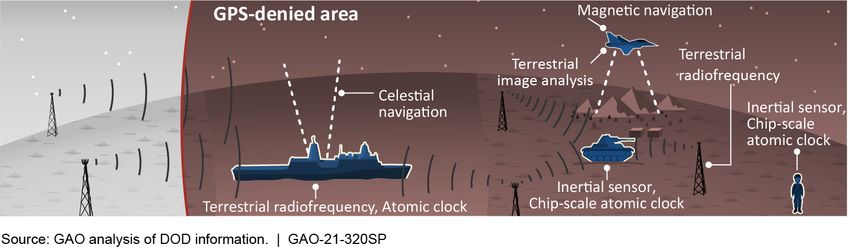
regardless of threat environments (see fig. 9). to transition will likely be billions of dollars
greater than the $2.5 billion identified
Development and integration of PNT through fiscal year 2021 because of significant
solutions, however, is currently a long and
costly process and results in proprietary
solutions that cannot easily incorporate other
solutions, if at all. For example, we have
previously reported that it has taken more
than a decade for the military services to
Defense Navigation Capabilities GAO-21-320SP 19remaining work. 16 DOD officials and experts military services’ reference architectures to
stated that new PNT capabilities must be ensure interoperability. 20
integrated and fielded more rapidly to keep
up with the pace of emerging threats to GPS. One part of the service-level PNT reference
architectures is interface standards. The Army
To decrease the time and cost needed to PNT reference architecture specifies interface
integrate and field new PNT capabilities, standards, whereas the Navy PNT reference
several efforts are underway across DOD to architecture states that its next phase should
implement modular open systems further refine system interface standards.
approaches (MOSA). 17 Modularity refers to DARPA initiated development of an open
the ability to easily swap out discrete interface standard for PNT, called the All-
hardware components or software functions Source Positioning and Navigation standard,
of a system. Openness refers to PNT interface that the Army and Air Force have used, and
standards that are widely known and an Army official considered it to be the de
available to the development community. 18 facto standard to communicate PNT
information. The open architecture initiative
The Army and Navy have each developed a is meeting with the military services and other
service-level PNT reference architecture that key stakeholders, such as industry, and
defines a MOSA for PNT, and the Air Force is working to update the standard.
just beginning to develop its own. 19 Under the
open architecture initiative, the Army plans to 3.2.1 Potential benefits of a modular open
draft and solicit input on a DOD-wide MOSA systems approach for PNT
PNT reference architecture to standardize the
common elements across the individual DOD is implementing MOSAs that, among
other things, employ a modular design that
uses major system interfaces between major
16 interchangeability, interconnection, interoperability,
GAO, GPS Modernization: DOD Continuing to Develop New
Jam-Resistant Capability, But Widespread Use Remains Years compatibility, or communications. Department of Defense,
Away, GAO-21-145 (Washington, D.C.: Jan. 19, 2021); and Department of Defense Standard Practice: Defense Standards
Global Positioning System: Better Planning and Coordination Format and Content, MIL-STD-962D w/ Change 2 (Jan. 9, 2014).
Needed to Improve Prospects for Fielding Modernized 19
DOD defines a reference architecture as an authoritative
Capability, GAO-18-74 (Washington, D.C.: Dec. 12, 2017). source of information about a specific subject area that guides
17 and constrains the instantiations of multiple architectures and
GAO has previously reported on DOD weapon system
requirements and systems engineering and DOD solutions. Solution architectures are frameworks or structures
implementation of modular open systems approaches for that portray the relationships among all the elements of
unmanned aircraft systems. GAO, Weapon System something that answers a problem. Department of Defense,
Requirements: Detailed Systems Engineering Prior to Product Office of the Department of Defense Chief Information Officer,
Development Positions Programs for Success, GAO-17-77 Reference Architecture Description (June 2010).
(Washington, D.C.: Nov. 17, 2016); and Defense Acquisitions: 20
A DOD-wide Reference Architecture provides information,
DOD Efforts to Adopt Open Systems for Its Unmanned Aircraft guidance, and direction applicable across DOD in a specific
Systems Have Progressed Slowly, GAO-13-651 (Washington, subject area. The five elements of a DOD-wide Reference
D.C.: July 31, 2013). Architecture are strategic purpose, principles, technical
18 positions, patterns (templates), and vocabulary. Department of
DOD defines an interface standard as a standard that
specifies the physical, functional, or military operational Defense, Office of the Department of Defense Chief
environment interface characteristics of systems, subsystems, Information Officer, Reference Architecture Description (June
equipment, assemblies, components, items, or parts to permit 2010).
Defense Navigation Capabilities GAO-21-320SP 20system components, such as PNT system allows greater industry participation since
components, in all of its major defense companies can focus on the development of
acquisition programs. 21 The department seeks one or a few PNT components and functions
to realize benefits such as significant cost that comply with the interfaces as defined in
savings or avoidance, schedule reductions and the MOSA and not be locked out because of
more rapid deployment of new technologies, other companies’ proprietary interface
opportunities for technology upgrades and standards (see fig. 10).
refreshes, and increased interoperability.
Many of these benefits are relevant to PNT.
Because the traditional method of technology
integration is long and costly, DOD considers
a PNT MOSA to be critical for integrating the
alternative PNT technologies into the
numerous types of platforms in use. In
addition, one expert stated that a MOSA will
allow integration of existing sensors on
platforms to aid in the development,
integrity, and assurance of a combined PNT
solution independent of GPS. Using
modularity and open standards can
potentially reduce integration efforts since a
MOSA architecture is designed to replace or
refresh components and functions without
significant impacts to the overall system. For
example, one expert said that DOD is slow to
issue updates to GPS receivers because of the
cost associated with upgrading the numerous
quantities of GPS receivers used in DOD (e.g.,
an Army official stated that the Army has
500,000 GPS receivers). Implementing a
MOSA in receivers could reduce integration
costs for future updates.
Using a MOSA can increase competition and
innovation because DOD would not be as
dependent on proprietary systems. A MOSA
21
10 U.S.C. § 2446a requires that DOD major defense
acquisition programs be designed and developed, to the
maximum extent practicable, using a MOSA that, among other
things, employs a modular design that uses major system
interfaces between a major system platform and a major
system component or between major system components.
Defense Navigation Capabilities GAO-21-320SP 21As discussed in the summary of the 2018 approach enables companies to focus on
National Defense Strategy, DOD states that it development of specialized PNT components
is pursuing a more lethal Joint Force and the and functions without needing to invest in the
strengthening of alliances. 22 The Strategy also development of entire PNT systems.
states that interoperability is a priority for
information sharing among the combined There are also potential performance
forces. Open interface standards can promote considerations relevant to current PNT
interoperability across the military services systems. An agency official with the open
and allied forces since the standards make architecture initiative and experts stated that
known what data are being communicated PNT systems such as combined GPS and
and how. inertial sensors achieve high performance
because they are integrated such that they
3.2.2 Considerations affecting modular support, and are highly dependent on, one
open systems approaches another. However, the agency official also
said that in a MOSA, being modular requires
While there are potential benefits, there are the components to be discrete and less
also many considerations that can affect the dependent on one another, which could
development and use of a MOSA in PNT, such result in a decrease in system performance. A
as acceptance by the relevant communities, contractor supporting the open architecture
system performance, cybersecurity, initiative hopes that a MOSA can be
certification, and governance and implemented that does not compromise
sustainment. system performance and that demonstrates
the benefits of a MOSA, such as increased
One expert said a MOSA’s success depends on opportunities for future technology upgrades,
it being able to provide benefits to relevant outweigh the potential loss in performance.
communities and making each of them
successful. Advocates of a MOSA can inform Cybersecurity is another consideration with a
the acquisition community that such an MOSA. In transitioning from a traditionally
approach provides cost advantages while closed PNT system developed by one prime
enabling the warfighter with the capability to contractor to a modular open system with
respond to new threats. The principles of known interfaces that uses components from
MOSA can also benefit the sustainment many contractors, DOD has stated it is
community (e.g., by potentially increasing the important that new vulnerabilities are not
availability of replacement parts to address introduced and that architectures be
obsolescence) and provide useful operational protected from cybersecurity threats. Both
capabilities to the user community through the Army and Navy PNT reference
technology upgrades. Advocates can show the architectures include cybersecurity
industry community how their proprietary requirements. 23
capabilities are protected and how this
22 23
Department of Defense, Summary of the 2018 National GAO has previously reported on DOD cybersecurity. GAO,
Defense Strategy of the United States of America (Jan. 19, Information Technology: DOD Software Development
2018). Approaches and Cybersecurity Practices May Impact Cost and
Defense Navigation Capabilities GAO-21-320SP 22You can also read