Designing an Integrated Map for a Visionary Public Transport System in Dublin - Aris Venetikidis - June 2010
←
→
Page content transcription
If your browser does not render page correctly, please read the page content below
Designing an Integrated Map for a Visionary Public Transport System in Dublin   Aris Venetikidis

Designing an Integrated Map
for a Visionary Public Transport
System in Dublin
Aris Venetikidis

June 2010
Designing an Integrated Map for a Visionary Public Transport System in Dublin Aris Venetikidis
2 Appendix 2 – Case Study
Case Study
Getting from O’Connell Street to Argos Car Rental
A realistic problem scenario was set up to explore possible pitfalls and shortcomings
of public transport in Dublin – many of which had been indicated in responses of the
survey. This case study intended to generate a step-by-step analysis of frequent prob-
lems. The scenario was a single individual wishing to travel from a central location (to
be fair) to a realistic destination, such as Argos Car Rental in Dublin South
23/04/2010 04:48
Rental Locations Hotels Book Now Contact Us Van Hire Rental Conditions
South Dublin City Car Hire
e is What you Pay! -
Car Hire in Dublin South City
Address:
The Chapel
y Mount St Anne’s
cation? Milltown
Dublin 6
Ireland
Phone: +353 1 499 9600
Opening Hours
Mon-Fri:9.00 - 17.30
Sat: 9.00 - 17.30
up:
Car Hire Dublin
all Dublin is divided by the river Liffey but with Argus rent a car Dublin you can
explore anywhere in the city with one of our hire cars. Drop in to our head offices
CS.01 – Argus CarinRental
south Dublin and we will take care of you, giving you the best service and the
website – address CS.02 – Case Study – Journey origin: O’Connell St.
best car at the right price. Dublin in recent years has undoubtedly become one of
the most popular places in Europe to visit or stay in and with good reason. The
reasonsstarting
CS.01 – A standard why people comeoften
point here are endless
is an and theIn
address. possibilities
this examplefor enjoying
test subject A.
oneself here are many. Dublin is Ireland's capital city (Belfast and Cork are the
island's other
wishes to reachaccommodated two
a car rentalmany major
company cities) and since its beginning around 988AD
in South Dublin city. Very few businesses wouldit has
diverse nationalities from the Vikings to the English
give detailed descriptions
invaders to the of howtraders
sailors, to get andtowriters
them, who particularly
settled and livedby public
here transport. The
over the
centuries. With an Argus hire car Dublin you can fully explore South county
most common extent of website directions is an embedded googlemaps window (often
Dublin and the surrounding area.
not even that). Getting
At theTotimeDublin ofbythis
Air case study, there were not even any public transport
Getting to Dublin by air is increasingly easy and popular, with many airlines
tags in Dublinsopening new routes Where
GoogleMap. and the emergence
many other
never been a better time to fly to Dublin.
of cheap air-travel
cities havein Europe there has
developed a culture of us-
nd - A better way to
ing public transport stops and hubs as landmarks and orientation points, in Dublin the
Dublin International Airport is about 12km north from of city centre, and is well
serviced by buses and taxis. The Airport is managed by Aer Rianta and you can
mostoflikely
g to hire a car outside Ireland,landmark to be referred will often be the nearest pub.
hire a car directly at the arrivals hall from Argus Car Hire.
page.
Car Hire Dublin South City
Argus provides you with top class quality and service, every time, car hire is easy
RANTEED! CS.02 – Armedwith
with hisGet
Argus. printed outquote
an instant website anda simulating
for hiring a visitor
test
car in Dublin using or non-native,
our booking
options! service on the left of this page.
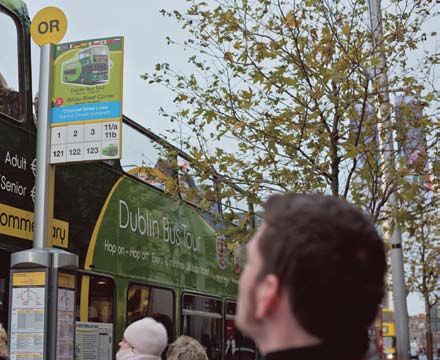
s! subject A. starts his journey on a central connection point – O’Connell Street. Maybe he
n extras!
knows Dublin Bus Head Office is located here and he wishes to get information there.
OW!
BOOKING
rds International Cancel Booking Need Help? Campervan Hire Privacy Policy T&C's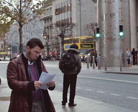
Designing an Integrated Map for a Visionary Public Transport System in Dublin Aris Venetikidis
Appendix 2 – Case Study 3
Not all journeys have a start as favourable as O’Connell Street. Travelling from a decen-
tral location to another can be incredible complex, but that was avoided in this example.
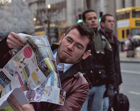
CS.03 – The only map in all the information stands at Dublin Bus Head Office (time
of case study: Jan. 2009) is the common Dublin Visitor Map (by the Dublin City Busi-
ness Association - see map in CS. 03). This map is of no help. It only shows a small area
of Dublin (the city centre from the Grand Canal in the South and Dorset Street in the
North). The is no greater Dublin area refernce. There is no way for test subject A. to
know this. He is searching for “Terenure Road East”, “Rathgar” or “Argus Car Rantal”.
Even if the destination were included on this map, the only bus rendered on the map is
CS.03– Standard Issue: Dublin Visitor Map CS.04 – Trying to identify route by destination
the “Dublin City Hop on Hop off” tour. Ironically, both LUAS lines and the DART line
is included.
CS.04 – There is a confusingly large number of stops along both sides of O’Connell
Street. There are no maps that would show the bus network, no information terminals.
In fact, there is not a single bus shelter on this street. Even bus shelters would not offer
sufficient information to help test subject A. They currently display a small map that list
the districts and buses that go there. The city centre is not included in this rendering and
there is no way of knowing where to pick up any bus.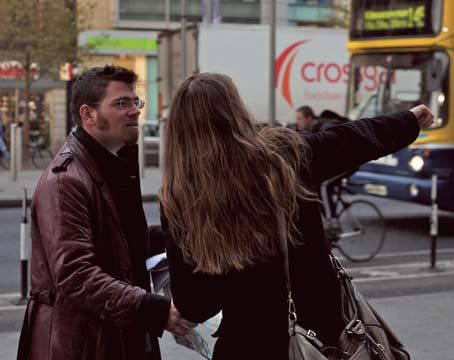
Designing an Integrated Map for a Visionary Public Transport System in Dublin                       Aris Venetikidis

4   Appendix 2 – Case Study

    CS.05 – The only way to resolve any questions about destinations is to ask bus drivers.
    Questions that bus drivers frequently encounter range from reassurance that it is the
    correct bus to what bus to take to reach destination X. Frequently, there is a long queue
    waiting to board the bus and approaching the driver for a question can be daunting. A
    lot of the fares payment is still handled by the driver and he also seems to be responsible
    for checking every boarding person’t ticket (including the people using prepaid tickets or
    smart cards). Furthermore there is constant pressure of keeping the bus in its scheduled
    time. Therefore, drivers can be extremely busy and short in time. While many respon-
    dants to the survey mentioned extremely unfriendly and brisk drivers, the author’s
    personal experience generally finds bus drivers to be surprisingly helpful and friendly,

    CS.05 – Asking bus driver for directions                      CS.06 – Looking for bus stop for route 15A

    particularly in light of the pressure they are under. Naturally, there are exceptions. In
    this case study, subject A. is informed by a bus driver that Ternure Road East would be
    served by the route 15A, “down the road“ is the direction.

    CS.06 – Walking down O’Connell Street there is an overwhelming number of bus poles
    (16 bus stops – 8 on each side). Each stop is called O’Connell Street. There are yellow
    markers with a two letter code on top of the poles. At the time of this case study, no key
    was readily available. Since Feb. 2010 a new map (Dublin Bus Network 2010) offers an
    index that lists the buses per unique letter combination. Curiously, this map is only avail-
    able at the Dublin Bus Head Office and even to date, the map that is on general display
    there (May 2010) still is the above mentioned “Dublin Visitor Map“. The much more
    helpful “Dublin Bus Network 2010“ map is handed out upon request, therefore only at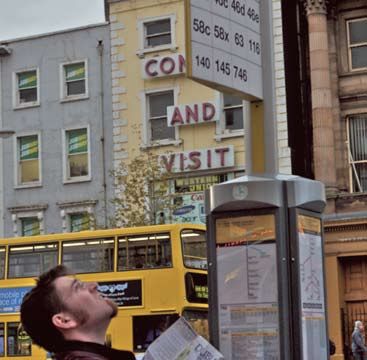
Designing an Integrated Map for a Visionary Public Transport System in Dublin                     Aris Venetikidis

                                                                                              Appendix 2 – Case Study   5

the information counter. The bus poles also feature a list of the route numbers that are
scheduled to stop there. Subject A. is walking down O’Connell Street in the direction
pointed out by the bus driver, scanning each bus pole for route number 15A.

CS.07 – After passing 6 bus poles with no 15 A in sight, subject A resorts to asking pe-
destrians. With the vast amount of bus routes in Dublin (well over 150) even proficient
bus users would typically only know bus routes they use themselves. Even many Dublin
natives are overwhelmed by the bus network (see survey results). Eventually, a passer-
by tells subject A that the 15A bus starts from across the river, at Trinity College

CS.07 – Locating stop for route 15A                           CS.08 – Problems with route naming system

CS.08 – Along the way, subject A encounters a parking bus with the route number 15B.
If instructed to look for a 15A it is natural to suspect that the 15B might run on a similar
alignment, yet, the different letter can in many cases mean that the bus reaches the same
destination on a different route or that it diverts of the desired route before reaching the
desired destination. The parking 15B has its lights on at the upper deck only, the doors
are closed and nobody is inside. There is a sign saying “set down only”, no time tables.
And since there is no evidence of any 15A the search continues.

CS.09 – Subject A crosses the river, still following the direction pointed out by the bus
driver and more specifically, the pedestrian. He now enters the D’Olier Street/Westmo-
reland Street fork, where northbound and southbound buses run on entirely different
streets. Still screening the bus poles for the number 15A, he finds bus pole CK. It fea-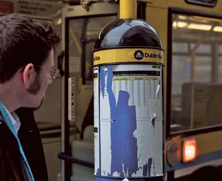
Designing an Integrated Map for a Visionary Public Transport System in Dublin      Aris Venetikidis

6   Appendix 2 – Case Study

    tures bus routes 14, 14A, 16 and 16A. But where is the 15A? The numbering system can
    not be expected to run in sequence everywhere, but when walking down past the bus
    stops in the city it does not seem to follow any recognisable pattern. Sequences may be
    torn apart, but sometimes, run alongside (120, 121, 122).

    CS.10 – Eventually, subject A finds the right stop (next to Trinity College). The time-
    table does not list the full list of stops for every route, even when bus travellers may often
    be instructed to get off the bus at a specific stop. The route 15A indicates a time 4 min-
    utes later. Oblivious to subject A, the listed times do not relate to this stop, but the origin
    of this route. There is no indication on the timetable that this is the case. Unbeknownst

    CS.09 – Where is 15A?                                         CS.10 – Timetables

    to subject A the 15A bus starts one stop prior to Trinity College, but this discrepancy can
    – in other locations – be devastating. Apart from buses often running in very irregular
    frequencies (contradicting frequencies indicated by timetables), the fact that timetables
    relate to the origin and not the current stop cause people to generally have little faith in
    the timetables. Even if the customer knew that the indicated times relate to the origin,
    many customers, particularly foreigners and tourists, would have no sense of where
    these places are, how far they are and how long a bus could possibly take to reach the
    current location.

    CS.11 – People ahead of subject A all name a fare to the driver. The bus system does
    not work by identifying destinations (very confusing to non-natives). There are very few
    vending machines at bus stops (even central ones) that would help identify the right fare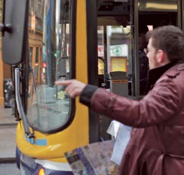
Designing an Integrated Map for a Visionary Public Transport System in Dublin                      Aris Venetikidis

                                                                                               Appendix 2 – Case Study   7

and avoid long queues. The author is only aware of vending machines at Dublin Air-
port. Currently, the bus stops and stages do not all have unique names (there are 5 Cork
Street stops, 9 South Circular Road Stops etc.). They rarely are named by landmarks in
the area or local side streets but more generally the street they run on (often very long).

CS.12 – The bus driver does not know Argus Car Rental, but fortunately Terenure
Road East and names a fare. To date, a large percentage of payment is still handled in
cash. The out-of-date autopay system does not give any change. Fares have to be paid
in exact amounts. Notes are not accepted – a potentially very big problem, as failing to
have enough coins leads to having no other option but to leave the bus.

CS.11 – Naming a fare upon entry                              CS.12 – No bank notes accepted

CS.13 – Fortunately, another customer agrees to change the 5-Euro note into coins. For
the overpaid amount instead of cash a printed refund ticket is printed, not redeemable in
buses. The one place that issues refunds in Dublin is the Dublin Bus Head Office. As a
result, may refunds remain unclaimed. Accidental overpayment results in the same.

CS.14 – Subject A is now inside the bus and has no remote idea of how long the journey
will take and when to get off the bus. He searches in vain for a simple timeline that lists
all stops in sequence. After 10 Minutes travel he gets increasingly nervous.

CS.15 – Surprisingly, stops are not announced (neither by display nor audio – a display
in the upper deck only displays “Stopping”). The station names on bus shelters and poles
are printed so small, that they can not be identified from inside an approaching bus.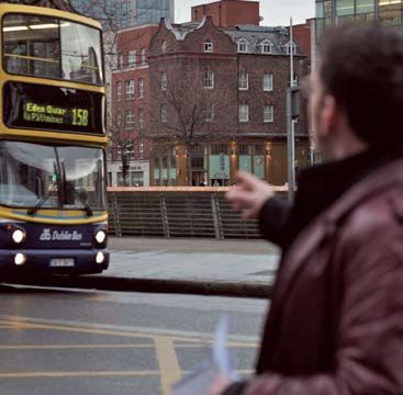
Designing an Integrated Map for a Visionary Public Transport System in Dublin                       Aris Venetikidis

8   Appendix 2 – Case Study

    CS.16 – Ignoring the sign “Do not to talk to the conductor during driving”, subject A
    asks for orientation. The driver promises to inform subject A, when to get off the bus. At
    this point, he has to trust that the driver remembers to do so. Subject A can not lean back,
    enjoy the drive, read or listen to music but is in constant alert for a notice by the driver.

    CS.17 – Fortunately, the driver remembers to inform subject A. to get off the bus. If he
    had not (which happens occasionally, not always by the driver’s fault but say, when driv-
    ers get exchanged during the journey), subject A could be in for a big tour.

    CS.13 – Problems around AutoPay system                         CS.14 – Lack of in-vehicle information

    CS.18 – The small stops and stages in the outlying areas tend to heva even less informa-
    tion than the ones in the city centre. There still stops without are carrousels or where
    these do not feature any timetables. Of course, subject A. is still oblivious to the times
    in these timetables not relating to the local stop but to the origin of this route. Luckily,
    subject A. finds Argus Car Rental quickly and ends his public transport experience.

    This case study was carried out in Jan. 2009 in a realistic scenario that illustrates the
    shortcomings of using Dublin Bus for travelling. This experience can be extremely
    stressful and confusing for anybody new to the system.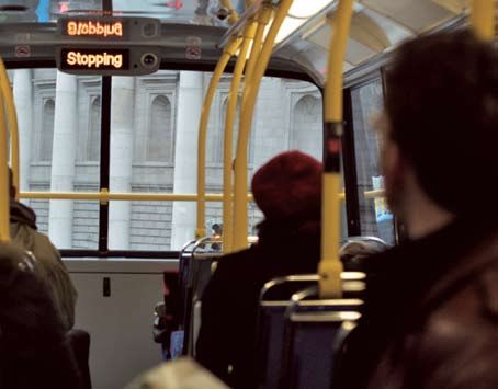
Designing an Integrated Map for a Visionary Public Transport System in Dublin                         Aris Venetikidis

                                                                                                  Appendix 2 – Case Study   9

CS.15 – No display/audio announcements of stops                CS.16 – Resorting to help from bus driver

CS.17 – Getting notice, where to get off the bus               CS.18 – Poor information in outlying areas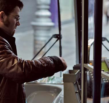
Designing an Integrated Map for a Visionary Public Transport System in Dublin              Aris Venetikidis

10     Appendix 2 – Problem Analysis Diagram

     Problem Areas:
     and their interrelation

     Bus Stop Names                                      Payment and Ticketing                Integrated Route Map

         bus stage names are not                               coin-based “Autofare“
               announced                                         (no change given)

                                                                                                        lack of a route map
                                                               flimsy ticket/little info
                                                                                                      that displays the names
          People don’t know                                                                                of bus stages
           bus stage names                                       refund can only be
                                                              claimed at one location
                                                              (limited opening hours)                     Lack of a
         complicated upon entry:
           naming destination                                                                          comprehensive
                                                                standard fare: can’t                     Route Map
                                                               change bus/transport
           no list of stage names
          inside buses or at stops                          need for integrated ticket
                                                            (Metro, LUAS, DART, Bus)

        passenger does not know                                                                   Options for connections
             when to get off                                 fare by number of stops:             are not communicated
                                                                incomprehensible

     Effects:

        People pay the wrong fare
                                                                                           Disorientation
             (i.e. too much)

     Interrelations of problems around Dublin Bus travel, six problem areas and four common effects
Designing an Integrated Map for a Visionary Public Transport System in Dublin Aris Venetikidis
Appendix 2 – Problem Analysis Diagram 11
Bus Shelters/Bus Stops Time Tables Routes
names on stops too small confusing rute numbers:
15, 15A, 15X etc.
often names on Stops do
not relate to landmarks
route number close to
each other need not have
central key stops are very complicated lists without destinations close to one
complex (panned out colour coding and badly another
stopping points) laid out
star-based routing
no means of knowing times displayed relate to (most bus routes squeeze
arrival time or distance to bus departure at origin through the city centre)
next connection
need for circular
(orbital) routes
Long waiting time, not
Conjested City Centre
knowing time ‘til connectionYou can also read