DIGITAL MAPPING TECHNIQUES 2021
←
→
Page content transcription
If your browser does not render page correctly, please read the page content below
DMT 2021

DIGITAL MAPPING TECHNIQUES 2021
      The following was presented at DMT‘21
        (June 7 - 10, 2021 - A Virtual Event)

      The contents of this document are provisional

           See Presentations and Proceedings
          from the DMT Meetings (1997-2021)
           http://ngmdb.usgs.gov/info/dmt/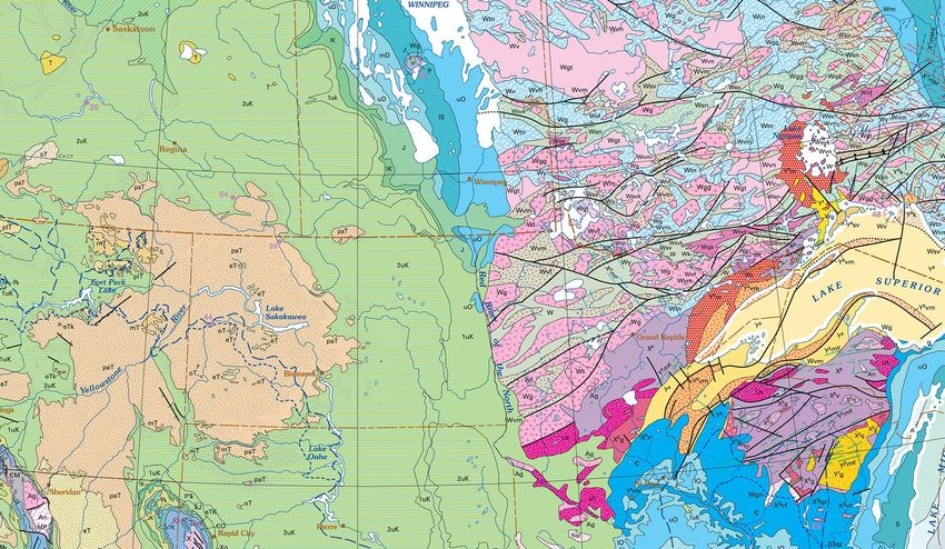
Mapping the geology of the
                             world in the 2020s
                                                                                         Harvey Thorleifson
                                                                             Director, Minnesota Geological
                                                                                                    Survey
                                                                        Chair, AASG Information Committee
                                                                                  Chair, Commission for the
                                                                            Management and Application of
                                                                                    Geoscience Information

This draft discussion was prepared by a CGMW-CGI-1G working group, to stimulate and support broad discussion and consensus
                               development under the global governance of CGMW, CGI, and 1G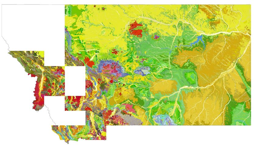
This draft discussion was prepared by a working group, to stimulate and support
broad discussion and consensus development under the global governance of the
Commission for the Geological Map of the World (CGMW), CGI, and
OneGeology. People strive for safety, health, wealth, and respect for their human
and natural heritage. Geological knowledge is needed by society to fulfil all of these
aspirations. We provide this geology through research, mapping, monitoring,
modeling, and management. These efforts are meant to clarify energy, minerals,
water, hazards, civil engineering, and research. There is an urgency for us to better
enable management of these topics. Examples of pressing applications that now
need queryable and model-ready geology include sedimentary basin analyses,
mineral resource assessment, inclusion of groundwater in regional water resource
management, hazards modeling such as for earthquake propagation and magnetic
storm vulnerability, infrastructure design, and all research on our planet and its life.
This presentation therefore will focus on the current state and anticipated future of
geological mapping that is needed by society.
•   People strive for safety, health, wealth, and
                   respect for their human and natural heritage
               •   Geological knowledge is needed by society to
                   fulfil all of these aspirations
               •   We provide this geology through research,
                   mapping, monitoring, modeling, and
                   management
               •   These efforts are meant to clarify energy,
                   minerals, water, hazards, civil engineering, and
                   research
               •   There is an urgency for us to better enable
                   management of these topics

Introduction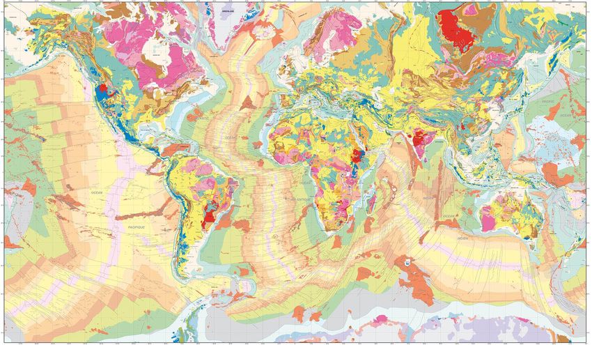
•   Examples of pressing applications that now
                   need queryable and model-ready geology
                   include sedimentary basin analyses, mineral
                   resource assessment, inclusion of groundwater
                   in regional water resource management,
                   hazards modeling such as for earthquake
                   propagation and magnetic storm vulnerability,
                   infrastructure design, and all research on our
                   planet and its life
               •   This presentation therefore will focus on the
                   current state and anticipated future of
                   geological mapping that is needed by society

Introduction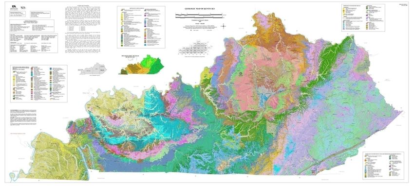
•   All mapping is guided by a specification, and
              ongoing assessment of progress
          •   Mapping encompasses the atmosphere, land
              surface, water depths, soil, and geology
          •   Geological mapping thus is an asset in our
              geospatial knowledge infrastructure

Mapping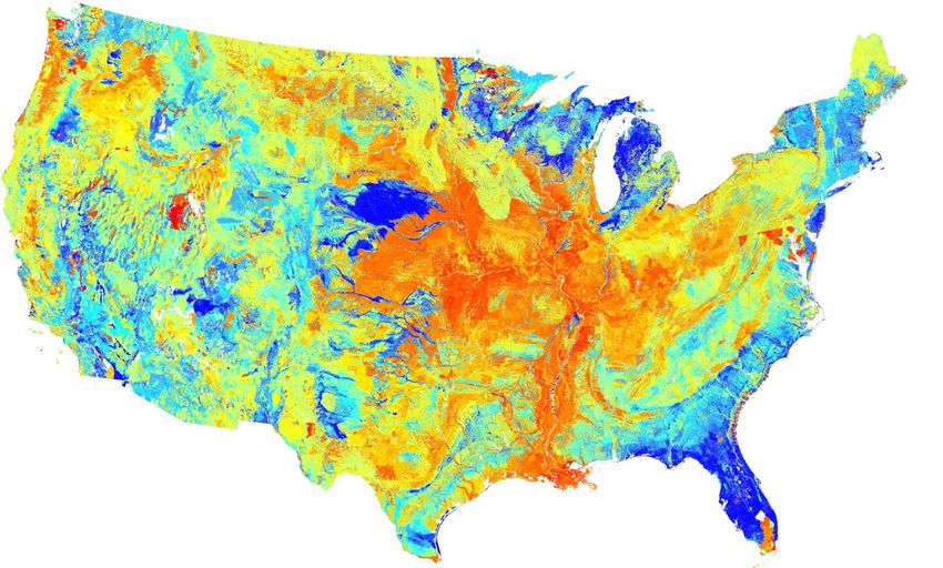
•   Due to sparse data and the need for
              interpretation, geologic maps are authored by
              active researchers who can visualize the
              geology
          •   Our research informs our mapping, and our
              mapping informs our research
          •   While academics balance research, teaching,
              and service, survey geologists balance
              research, mapping, and service

Geology                             http://www.geologypage.com
•   In geological mapping, we have focused on 2D
                    maps that are not necessarily positioned
                    vertically nor fully categorized, although each is
                    seamless and includes some 3D

Geologic maps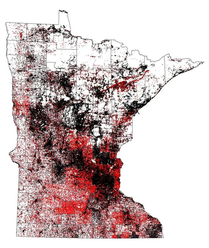
•   In resources, hazards, and engineering,
                   geological maps need to be translated and
                   augmented as derived maps

Derived maps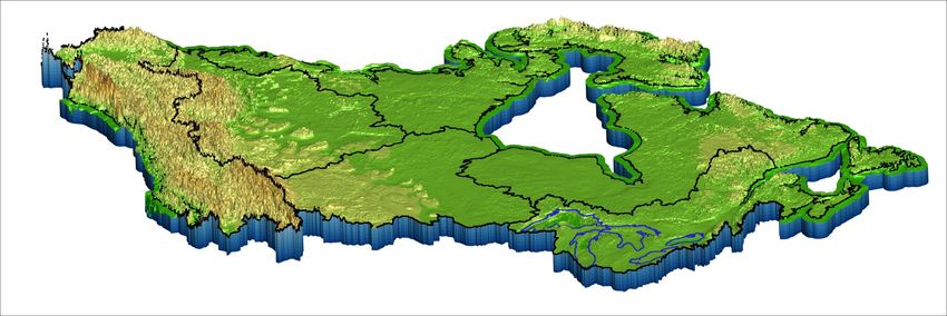
•   For the US, a simple definition of detailed
                    mapping is any new map more detailed than
                    your state geologic map

Detailed maps
• Detailed geological maps are based largely on
fieldwork, or by assembling data such as a
bedrock map in an area of complete sediment
cover
Detailed maps• Compilations are based on assembly and
reconciliation of multiple published maps
Compilations• Coordination with neighbors is an essential
activity that leads to efficiency and consistency
needed by users
Cross-border coordination• Paper-format 2D geological maps have distinct
advantages, and in the future will be more
important than ever
Paper maps• Geological mapping returns a very positive
cost/benefit
Benefits• Observations enable the inferences we convey
as mapping, for the purpose of supporting
applications
• These data enable our mapping, and our
mapping is a window to the data
• Our data need to be findable, accessible,
interoperable, and reusable
Data• Each database of observations, collections, or
measurements requires ongoing assessment,
under data stewardship programs
Data• In the digital era, compilations no longer have to
be generalized to fit on paper• Queryable seamless databases that can be
updated therefore have emerged, in all mapping
fields
• It seems likely that paper-format geologic maps
in the future will mainly be used as PDFs by eye,
and GIS users will mainly use seamless
• We have to ask whether it will be possible, or
even desirable, to save the GIS files for every
paper map, forever• Soil mapping and geological mapping are the
same thing; soil mappers think in cm, whereas
geologic mappers think in m and km
• Soil mapping has shifted from static, printed
soil surveys to a dynamic, seamless database,
including a gridded version
• Users are dictating that soil mapping will be the
authoritative reference for geologic properties
for the 1st m on land
Soil mapping• Concurrently, there is accelerating coordination
between geology and underground mapping of
pipes, wires, and tunnels
Underground structures• Seamless is a standardized compilation, without
generalization, and with ongoing harmonization
and facilitation of query
• Seamless shows gaps, for reasonably
consistent resolution, to show where mapping
is needed, and to attract funding
• Lower resolution mapping can be used to infill
gaps to make a best-available map for some
users
Seamless• In 3D, vertical position and properties of
surfaces, strata, and structures are specified to
the extent allowed by data and confident
inference
• In 3D, a layer is a seamless 2D map polygon
whose thickness can be mapped
• For layers, we map extent, vertical position,
thickness, properties, heterogeneity, and
uncertainty
• An indication of dominant lithology provides a
basis for inference of properties such as
hydraulic conductivity
3D• Below the layers is basement; in layers, we map
strata, and in basement, we map structures,
then discretized properties
Basement• To support a 3D program, jurisdiction-wide,
onshore/offshore, and cross-border cross-
sections are needed at the outset
Cross-sections• This will help resolve stratigraphic issues, and
clarify surfaces to be mapped; for North
America, we need a new COSUNA
COSUNA• 3D also requires much long-term effort on data
compilation and new geophysical surveys, with
emphasis on jurisdiction-wide public-domain
drillhole data
Data• 3D mapping can be expressed as a grid of
synthetic drill holes, that may be linked to a
gridded version of the 2D map
Synthetic drill holes• It is clear that everything is becoming digital
and quantitative, and that mapping is essential
for modeling and management• Modeling may be done on a one-time project
basis, or as an indefinitely maintained digital
twin
Digital twins• The 1st and most important step in modeling is
the conceptual model, a qualitative depiction
that guides quantification
Conceptual model• All information is most usable if standardized,
and users demand standardization
Standards• The 2nd step in modeling is mesh, for all space
of interest, varying in resolution if necessary,
with uncertainty specified
Mesh• Geological mapping thus now involves:
1) maps,
2) standards,
3) seamless and 3D
Maps, standards, seamless and 3D• Geological maps function in the conceptual
model paradigm – primarily designed to be used
by eye, not necessarily positioned vertically, and
often not fully categorized
Conceptual model• Seamless and 3D function in the mesh paradigm
– quantifiable, complete for all horizontal and
vertical space in the are of interest, structured
resolution, with uncertainty indicated
Mesh• In seamless, legends are parsed to facilitate
query, and in 3D, everything is vertically
georeferenced
Parsing, vertical georeferencing• Geology is best done by geologists, rather than
modelers, resulting in model-ready, machine-
readable geology
Geology• Geologic maps primarily presented as research
publications and as conceptual models are
NGMDB Phase One – the catalog
• The standards needed to make our geologic
maps readily usable and interoperable are
NGMDB Phase Two
• Seamless and 3D are
NGMDB Phase Three – the framework database
NGMDB• Maps, standards, and seamless each have their
own paradigm, culture, and language; although
we need to unify 2D and 3D
• Paper maps and accompanying digital files are
static, authored publications that undergo one-
time peer-review
• Standards are developed by consensus in a
professional community, commonly guided by
standards organizations
• Seamless undergoes regular audits rather than
peer review, and will be revised indefinitely as
versioned databases
Culture• Geological mapping as we know it began with the
1815 William Smith geology of England and Wales
• Our 1st century involved national surveys and hand-
colored wall maps; our 2nd century involved the
printing press
• We have evolved since 1990 from photomechanical
paper maps, to digital paper maps, to catalogs, the
web, standards, seamless, and 3D. Soil mapping has
moved on to gridded, raster, and dynamic soil survey
• It can now be seen that our 3rd century likely will
focus on enabling model-ready geology, especially
for digital twins
History• All mapping has resolution levels, each with
appropriate generalization
• Resolution levels for geology are urban,
detailed, national, continental, and global
Resolution• To support query, completeness and
consistency are needed for each level of
resolution, which will be fulfilled for urban by
data rather than mapping
• We therefore need a geologic mapping
specification that can be completed in
foreseeable time
• Each 3D geology level of resolution will have a
data-availability-related floor below which the
next level will prevail
• The 2D map dictates the stratigraphic resolution
of accompanying 3D, to allow consistent query
• The 2D mapping will have higher horizontal
resolution than the 3D it is paired with, due to
the sparsity of subsurface data
Resolution• 1) standards to
support
interoperability
• 2) ongoing • In federal systems, much of the geological mapping is done
by subnational surveys that are focused on local needs
assessment of • Subnational surveys will indefinitely edit their jurisdiction-
wide seamless, as often as daily
progress • Maintenance of seamless requires standards to support
• 3) synthesis in part interoperability, ongoing assessment of progress , synthesis
in part to test harmonization, and iteration to incorporate
to test •
ongoing updates
Federal surveys have essential roles in detailed mapping,
harmonization required research, compilation, and information management
• 4) iteration to
incorporate
ongoing updates
Federal and subnational roles• These federal roles are based on broader thinking, as well as
specialized research and technology
• While the subnational role can focus more on completeness,
the federal role can be more focused on consistency
• Federal roles in detailed mapping include cross-border,
federal priorities, and mapping needed to optimize synthesis
• Federal roles also include housing national databases,
standards, and research need to optimize the program
Federal and subnational roles• Increasingly, researchers and resource
managers need usable GIS data for applications
ranging from urban to global
• Data largely comes from local governments,
mapping to a large degree from subnational
surveys, and synthesis might preferentially be
done by federal geological surveys
• Concurrently, most multinational geological
maps are published by the Commission for the
Geological Map of the World (CGMW)
CGMW• CGMW at present is focusing on a seamless
continental-resolution bedrock for the world to
support the global Deep-Time Digital Earth
(DDE) project
• However, those maps are missing layers, such
as a sediment layer for glaciated North America
• These activities thus need to be broadened,
from a limited conceptual model approach to a
full mesh paradigm
DDE• International geologic map standards are led by
the Commission for the Management and
Application of Geoscience Information (CGI)
CGI• Seamless 3D now needed for urban to global
digital twins is a task for OneGeology, which
presents itself as the provider of global
geoscience data
OneGeology• It can be foreseen that the CGMW global
resolution map will be translated into a 3D
geology, likely ignoring sediments
Global resolution 3D geology• The US Congress has directed us, and funded
us, to build detailed, national, and continental-
resolution seamless 3D
Funding• Urban applications largely will be addressed by
stewards of primary data, mostly as public
domain drillhole data
Urban• To support this next-generation geologic
mapping, in coming years and decades, we
need to coordinate with neighbors
• We need to assign thickness and properties to
our continental resolution rock layers
Continental resolution• We also need to add sediment 2D and 3D, and
basement
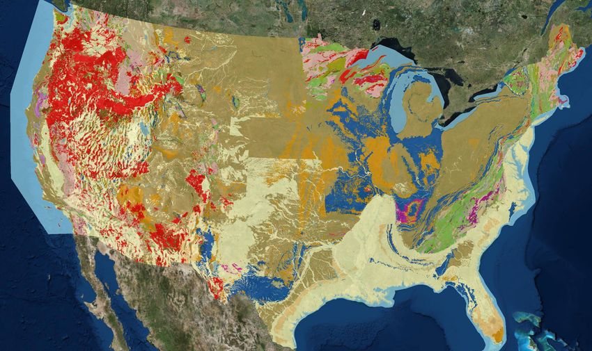
Continental resolution• For the US, we need to immediately accelerate
work on making the State Geologic Map
Compilation (SGMC) seamless, and then we
need to make the layers 3D
National resolution• At the detailed level of resolution, we need to
immediately accelerate field geology, new
mapping, and 2D seamless
Detailed resolution• Status mapping is required, to develop
consensus on goals, to monitor and manage our
progress, to identify priorities, to stimulate
funding, and to cause us all to strive. A status
map differs from a publication index, which
indicates the spatial footprint of published
maps, including obsolete, superseded maps.
Status mapping requires local knowledge,
judgement about needs, a composite index, and
thus an indication of progress toward evolving
goals
Status• This nationally standardized, annually updated
status procedure, implemented in stages, will
require consideration of 2D mapping, depth to
bedrock and basement or equivalent,
subsurface data and mapping of sediment and
rock layers, and basement mapping
Status• These developments in geological mapping will
rely on a great acceleration in data compilation
and geophysical surveys
Data compilation and geophysics• Concurrently, we need to accommodate
appropriate roles for geostatistics and methods
such as machine learning
• We need to work on all resolution levels
concurrently, with emphasis by far on detail, in a
planned, stepwise manner• In conclusion, I suggest that to think about the
future of geological mapping, we need to think
about nested dynamic models
• I now request your adviceMapping the geology of the
world in the 2020s
Harvey Thorleifson
Director, Minnesota Geological
Survey
Chair, AASG Information Committee
Chair, Commission for the
Management and Application of
Geoscience Information
This draft discussion was prepared by a CGMW-CGI-1G working group, to stimulate and support broad discussion and consensus
development under the global governance of CGMW, CGI, and 1GYou can also read


