Disaster Information Kit

        for the

   Caribbean Media
←
→
Page content transcription
If your browser does not render page correctly, please read the page content below
Disaster Information Kit
for the
Caribbean Media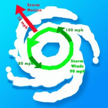
Disaster Information Kit

                                     for the

                     Caribbean Media

Disaster Information Kit for the Caribbean Media   Page 1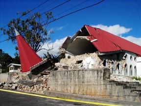
ISBN 976-95151-4-1

© 2004
Caribbean Disaster Emergency Response Agency (CDERA)
Building #1 Manor Lodge Complex
Lodge Hill
St Michael
Barbados
http://www.cdera.org

Disaster Information Kit for the Caribbean Media       Page 2
Contents
Acknowledgements .............................................................................. 2
Introduction ......................................................................................... 3
Disaster Management – what it is and why it is necessary ................... 4
Fact Sheets
         Tropical Weather Systems .............................................................. 14
                  Messages the media should give the to public ......................... 23
                  Glossary ............................................................................. 26
                  Contact information for weather services in the Caribbean ....... 34
         Earthquakes ................................................................................. 37
                  Messages the media should give to the public ......................... 44
                  Glossary ............................................................................. 47
         Tsunamis ..................................................................................... 51
                  Messages the media should give to the public ......................... 53
         Volcanoes...................................................................................... 54
                  Messages the media should give to the public ......................... 57
                  Glossary ............................................................................. 59
         Floods .......................................................................................... 72
                  Messages the media should give to the public ......................... 74
                  Glossary ............................................................................. 76
         Landslides .................................................................................... 77
                  Messages the media should give to the public ......................... 78
         Technological and man-made disasters ............................................ 79
                  Messages the media should give to the public ......................... 80
         Epidemics ..................................................................................... 81
                  Information the media should give to the public ...................... 83
Contact Directory ................................................................................. 91
Bibliography ......................................................................................... 97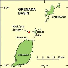
Acknowledgements
The 6th edition revision of this Media Kit was produced by the Caribbean Disaster Emergency
Response Agency (CDERA) with funding support from the United Nations Educational,
Scientific ad Cultural Organisation (UNESCO).

It benefited from the insights and guidance from a wide cross section of professionals who
met in Barbados, Jamaica, and Trinidad to review this edition. Among them, the Caribbean
Institute for Media and Communication (CARIMAC) at the Mona Campus of the University of
the West Indies, the Caribbean Media Corporation, the Office for Disaster Preparedness and
Emergency Management (ODPEM) of Jamaica, the Central Emergency Relief Organisation
(CERO) of Barbados, the National Emergency Management Agency (NEMA) of Trinidad and
Tobago, the International Federation of the Red Cross Caribbean Sub-Regional Office,
Trinidad, and the Caribbean Examinations Council (CXC).

This work built on the first edition (1995) which was prepared by a Working Group
comprising:

       Ms Patricia Bittner, PAHO, Washington DC, USA
       Mr Jeremy Collymore, CDERA, Barbados
       Mr Timothy James, Office of Disaster Preparedness and Prevention, St Lucia
       Mr Stephen Louis, CDERA, Barbados
       Ms Judy Thomas, Central Emergency Relief Organisation (CERO), Barbados
       Ms Wendy Thompson, Caribbean News Agency (CANA), Barbados
       Ms Sandra Ward, Department of Information and Public Relations, British Virgin
       Islands

With technical inputs from:

       Dr Jean-Luc Poncelet, PAHO, Barbados
       Ms Elizabeth Stonaker, PAHO, Washington DC, USA
       Caribbean News Agency (CANA)
       Caribbean Broadcasting Union (CBU)
       Caribbean Institute for Mass Communications (CARIMAC)

CDERA thanks the foundation team for their sterling work along with the 2004 team for
their time and expertise in revising to this publication.

Disaster Information Kit for the Caribbean Media                                 Page 2
Introduction
Disaster management is about life and death. A significant responsibility rests on the
shoulders of the disaster manager. A similar responsibility rests with the media, which is
one of the crucial communication links between the disaster manager and the general
public, particularly during a disaster.
It is vitally important therefore that the disaster manager and the reporter or editor work as
partners, that they talk the same language, understand the same jargon, and appreciate
and respect each other’s role.
It is against this background that this manual was conceptualised and written in 1995 and
again revised in 2004 both in print and also made available via the World Wide Web at
http://www.cdera.org/doccentre.
The objectives of the Kit are:
• To provide an easily accessible source of background information on disasters for
media practitioners in the Caribbean;
• To ensure consistent interpretation and reporting of basic disaster information by
media practitioners across the Caribbean;
• To alleviate the pressure placed on disaster management officials during
emergencies by the need to constantly explain basic concepts, terminology, and
practices to the media;
• To demonstrate recognition of the important role of the media in disaster
management and the commitment to increase cooperation and collaboration
between media and disaster management professionals.
Future revisions of this manual will be posted on the World Wide Web at
http://www.cdera.org/doccentre, which is the source for authoritative and accurate disaster
information.
Disaster Information Kit for the Caribbean Media Page 3Disaster Management
What is it and why it is necessary
Introduction
Disasters and their impact worldwide are increasing at an alarming rate. The number of
natural disasters affecting CDERA member states1 in the 1960s was 16. In the next decade
there were 13, in the 1980s the number increased to 41, with 48 in the 1990s and for the
first three years of the 21st Century there were already 13.
The cost of the damage was as high as 53 per cent of GDP of one CDERA member state and
such costs naturally set back the economic progress and development of a country.
There is an increase both in natural hazards and also in damage to property. The Inter
Governmental Panel on Climate Change has warned that the weather variability and long
term change in climate patterns are starting to affect the planet and they will result in
extreme and detrimental conditions in the coming years as more of an imbalance occurs.
The devastating floods in Guyana in January 2005 have brought the issue of erratic weather
patterns to the fore. Similarly the 2004 Boxing Day Indian Ocean tsunami has heightened
concern about the potential impact of local and tele-tsunamis on the Caribbean. Volcanoes
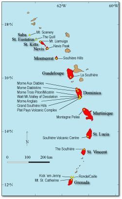
that have been dormant for centuries have rumbled to life with destructive and fatal results
in Montserrat while in Dominica 10 others are simmering. The underwater volcano, just
north of Grenada, Kick ‘em Jenny, is growing and may one day pose a threat to
neighbouring islands. A major eruption could shower Grenada and other islands with ash
falls, at best, or tsunamis at the worse. A 2003 survey of Kick ‘em Jenny found another
active submarine volcano which has been named Kick ‘em Jack.
Natural hazards occur as a normal part of earth’s cycle, the major difference in the last few
centuries was man. Man’s increased vulnerability comes as a result of:
1. Increasing population. Major disasters can now claim more lives;
2. Affluence is abounding. As people become wealthier they acquire more property
which if not constructed properly is vulnerable to any natural disaster;
3. The affluence and increased population means that more people and more property
are concentrated along the coastlines making them vulnerable to natural hazards;
4. As populations increase and development abound there can be environmental
degradation due to poor land use, deforestation, over cultivation, and over grazing.
These make the land more vulnerable to floods and landslides;
5. Increasing industrialization without the appropriate safety measures may result in
man-made accidents and disasters;
6. Absence of mitigation or preventative measures in development planning is usually a
recipe for a disaster.
1
Anguilla, Antigua and Barbuda, The Bahamas, Barbados, Belize, British Virgin Islands, Dominica, Grenada,
Guyana, Jamaica, Montserrat, St Kitts/Nevis, Saint Lucia, St Vincent and the Grenadines, Trinidad and Tobago,
Turks and Caicos Islands.
Disaster Information Kit for the Caribbean Media Page 4Definitions
Acceptable risk
The level of loss a society or community considers acceptable given existing social,
economic, political, cultural, technical and environmental conditions.
In engineering terms, acceptable risk is also used to assess structural and non-structural
measures undertaken to reduce possible damage at a level which does not harm people
and property, according to codes or "accepted practice" based, among other issues, on a
known probability of hazard.
Biological hazard
Processes of organic origin or those conveyed by biological vectors, including
exposure to pathogenic micro-organisms, toxins and bioactive substances,
which may cause the loss of life or injury, property damage, social and
economic disruption or environmental degradation. Examples of biological
hazards: outbreaks of epidemic diseases, plant or animal contagion, insect
plagues and extensive infestations.
Building codes
Ordinances and regulations controlling the design, construction, materials,
alteration and occupancy of any structure to insure human safety and welfare.
Building codes include both technical and functional standards.
Capacity
A combination of all the strengths and resources available within a
community, society or organization that can reduce the level of risk, or the
effects of a disaster. Capacity may include physical, institutional, social or
economic means as well as skilled personal or collective attributes such as
leadership and management. Capacity may also be described as capability.
Capacity building
Efforts aimed to develop human skills or societal infrastructures within a
community or organization needed to reduce the level of risk. In extended
understanding, capacity building also includes development of institutional,
financial, political and other resources, such as technology at different levels
and sectors of the society.
Climate change
The climate of a place or region is changed if over an extended period
(typically decades or longer) there is a statistically significant change in
measurements of either the mean state or variability of the climate for that
place or region. Changes in climate may be due to natural processes or to
persistent anthropogenic changes in atmosphere or in land use. Note that the
definition of climate change used in the United Nations Framework Convention
on Climate Change is more restricted, as it includes only those changes which
are attributable directly or indirectly to human activity.
Complex Disasters
Complex disasters exist where adverse political conditions compound a
disaster or emergency situation. Such situations are complicated because the
breakdown of the political structure makes assistance or intervention difficult.
This sort of emergency is usually associated with the problems of displaced
people during times of civil conflict or with people in need caught in areas of
conflict.
Disaster Information Kit for the Caribbean Media Page 5Comprehensive Disaster Management (CDM)
This is the new thrust for the 21st Century being promoted by CDERA. It
moves away from the approach of “response and relief” which characterised
Caribbean disaster management in the last century to a comprehensive mode
to include all hazards, all phases of the disaster management continuum
(prevention, mitigation, preparedness, response, recovery, rebuilding), and
all sectors of the society (economic, environmental, and social planners,
engineers, architects, insurance and banking industry among others).
Coping capacity
The means by which people or organizations use available resources and
abilities to face adverse consequences that could lead to a disaster. In
general, this involves managing resources, both in normal times as well as
during crises or adverse conditions. The strengthening of coping capacities
usually builds resilience to withstand the effects of natural and human-
induced hazards.
Counter measures
All measures taken to counter and reduce disaster risk. They most commonly
refer to engineering (structural) measures but can also include non-structural
measures and tools designed and employed to avoid or limit the adverse
impact of natural hazards and related environmental and technological
disasters.
Disaster
A serious disruption of the functioning of a community or a society causing
widespread human, material, economic or environmental losses which exceed
the ability of the affected community or society to cope using its own
resources. Though often caused by nature, disasters can have human origins.
Wars and civil disturbances that destroy homelands and displace people are
included among the causes of disasters. Other causes can be: building
collapse, blizzard, drought, epidemic, earthquake, explosion, fire, flood,
hazardous material or transportation incident (such as a chemical spill),
hurricane, nuclear incident, tornado, or volcano.
A disaster is a function of the risk process. It results from the combination of
hazards, conditions of vulnerability and insufficient capacity or measures to
reduce the potential negative consequences of risk.
Disaster Management
This is a collective term, which includes all aspects of planning for and
responding to disasters. It may also refer to the management of both the
risks and consequence of disasters.
Disaster risk management
The systematic process of using administrative decisions, organization,
operational skills and capacities to implement policies, strategies and coping
capacities of the society and communities to lessen the impacts of natural
hazards and related environmental and technological disasters. This
comprises all forms of activities, including structural and non-structural
measures to avoid (prevention) or to limit (mitigation and preparedness)
adverse effects of hazards.
Disaster Information Kit for the Caribbean Media Page 6Disaster risk reduction (disaster reduction)
The conceptual framework of elements considered with the possibilities to
minimize vulnerabilities and disaster risks throughout a society, to avoid
(prevention) or to limit (mitigation and preparedness) the adverse impacts of
hazards, within the broad context of sustainable development. The disaster
risk reduction framework is composed of the following fields of action, as
described in ISDR's publication 2002 "Living with Risk: a global review of
disaster reduction initiatives", page 23: · Risk awareness and assessment
including hazard analysis and vulnerability/capacity analysis; · Knowledge
development including education, training, research and information; · Public
commitment and institutional frameworks, including organisational, policy,
legislation and community action; · Application of measures including
environmental management, land-use and urban planning, protection of
critical facilities, application of science and technology, partnership and
networking, and financial instruments; · Early warning systems including
forecasting, dissemination of warnings, preparedness measures and reaction
capacities.
Early warning
The provision of timely and effective information, through identified
institutions, that allows individuals exposed to a hazard to take action to
avoid or reduce their risk and prepare for effective response. Early warning
systems include a chain of concerns, namely: understanding and mapping the
hazard; monitoring and forecasting impending events; processing and
disseminating understandable warnings to political authorities and the
population, and undertaking appropriate and timely actions in response to the
warnings.
Ecosystem
A complex set of relationships of living organisms functioning as a unit and
interacting with their physical environment. The boundaries of what could be
called an ecosystem are somewhat arbitrary, depending on the focus of
interest or study. Thus the extent of an ecosystem may range from very small
spatial scales to, ultimately, the entire Earth (IPCC, 2001).
El Niño-southern oscillation (ENSO)
A complex interaction of the tropical Pacific Ocean and the global atmosphere
that results in irregularly occurring episodes of changed ocean and weather
patterns in many parts of the world, often with significant impacts, such as
altered marine habitats, rainfall changes, floods, droughts, and changes in
storm patterns. The El Niño part of ENSO refers to the well-above-average
ocean temperatures along the coasts of Ecuador, Peru and northern Chile and
across the eastern equatorial Pacific Ocean, while the Southern Oscillation
refers to the associated global patterns of changed atmospheric pressure and
rainfall. La Niña is approximately the opposite condition to El Niño. Each El
Niño or La Niña episode usually lasts for several seasons.
Emergency management
The organization and management of resources and responsibilities for
dealing with all aspects of emergencies, in particularly preparedness,
response and rehabilitation. Emergency management involves plans,
structures and arrangements established to engage the normal endeavours of
Disaster Information Kit for the Caribbean Media Page 7government, voluntary and private agencies in a comprehensive and
coordinated way to respond to the whole spectrum of emergency needs. This
is also known as disaster management.
Environmental impact assessment (EIA)
Studies undertaken in order to assess the effect on a specified environment of
the introduction of any new factor, which may upset the current ecological
balance. EIA is a policy making tool that serves to provide evidence and
analysis of environmental impacts of activities from conception to decision-
making. It is utilised extensively in national programming and for
international development assistance projects. An EIA must include a detailed
risk assessment and provide alternatives solutions or options.
Environmental degradation
The reduction of the capacity of the environment to meet social and ecological
objectives, and needs. Potential effects are varied and may contribute to an
increase in vulnerability and the frequency and intensity of natural
hazards.Some examples: land degradation, deforestation, desertification,
wildland fires, loss of biodiversity, land, water and air pollution, climate
change, sea level rise and ozone depletion.
Forecast
Definite statement or statistical estimate of the occurrence of a future event
(UNESCO, WMO). This term is used with different meanings in different
disciplines.
Geological hazard
Natural earth processes or phenomena that may cause the loss of life or
injury, property damage, social and economic disruption or environmental
degradation. Geological hazard includes internal earth processes or tectonic
origin, such as earthquakes, geological fault activity, tsunamis, volcanic
activity and emissions as well as external processes such as mass
movements: landslides, rockslides, rock falls or avalanches, surfaces
collapses, expansive soils and debris or mud flows. Geological hazards can be
single, sequential or combined in their origin and effects.
Geographic information systems (GIS)
Analysis that combine relational databases with spatial interpretation and
outputs often in form of maps. A more elaborate definition is that of computer
programmes for capturing, storing, checking, integrating, analysing and
displaying data about the earth that is spatially referenced. Geographical
information systems are increasingly being utilised for hazard and
vulnerability mapping and analysis, as well as for the application of disaster
risk management measures.
Greenhouse gas (GHG)
A gas, such as water vapour, carbon dioxide, methane, chlorofluorocarbons
(CFCs) and hydrochlorofluorocarbons (HCFCs), that absorbs and re-emits
infrared radiation, warming the earth's surface and contributing to climate
change (UNEP, 1998).
Hazard
Disaster Information Kit for the Caribbean Media Page 8A hazard is an extreme, threatening event in the natural or man-made
environment that adversely affects human life, property, or activity, or the
ecosystem that supports them. A primary hazard disrupts human settlements.
A secondary hazard occurs in the aftermath of a primary hazard and
contributes to further suffering or loss.
Hazard analysis
Identification, studies and monitoring of any hazard to determine its potential,
origin, characteristics and behaviour.
Hydrometeorological hazards
Natural processes or phenomena of atmospheric, hydrological or
oceanographic nature, which may cause the loss of life or injury, property
damage, social and economic disruption or environmental degradation.
Hydrometeorological hazards include: floods, debris and mud floods; tropical
cyclones, storm surges, thunder/hailstorms, rain and wind storms, blizzards
and other severe storms; drought, desertification, wildland fires, temperature
extremes, sand or dust storms; permafrost and snow or ice avalanches.
Hydrometeorological hazards can be single, sequential or combined in their
origin and effects.
La Niña
(see El Niño-Southern Oscillation).
Land-use planning
Branch of physical and socio-economic planning that determines the means
and assesses the values or limitations of various options in which land is to be
utilized, with the corresponding effects on different segments of the
population or interests of a community taken into account in resulting
decisions. Land-use planning involves studies and mapping, analysis of
environmental and hazard data, formulation of alternative land-use decisions
and design of a long-range plan for different geographical and administrative
scales.Land-use planning can help to mitigate disasters and reduce risks by
discouraging high-density settlements and construction of key installations in
hazard-prone areas, control of population density and expansion, and in the
siting of service routes for transport, power, water, sewage and other critical
facilities.
Mitigation
Structural and non-structural measures undertaken to limit the adverse
impact of natural hazards, environmental degradation and technological
hazards.
Natural hazards
Natural processes or phenomena occurring in the biosphere that may
constitute a damaging event. Natural hazards can be classified by origin
namely: geological, hydrometeorological or biological. Hazardous events can
vary in magnitude or intensity, frequency, duration, area of extent, speed of
onset, spatial dispersion and temporal spacing.
Preparedness
Activities and measures taken in advance to ensure effective response to the
impact of hazards, including the issuance of timely and effective early
Disaster Information Kit for the Caribbean Media Page 9warnings and the temporary evacuation of people and property from
threatened locations.
Prevention
Activities to provide outright avoidance of the adverse impact of hazards and
means to minimize related environmental, technological and biological
disasters. Depending on social and technical feasibility and cost/benefit
considerations, investing in preventive measures is justified in areas
frequently affected by disasters. In the context of public awareness and
education, related to disaster risk reduction changing attitudes and behaviour
contribute to promoting a "culture of prevention".
Public awareness
The processes of informing the general population, increasing levels of
consciousness about risks and how people can act to reduce their exposure to
hazards. This is particularly important for public officials in fulfilling their
responsibilities to save lives and property in the event of a disaster. Public
awareness activities foster changes in behaviour leading towards a culture of
risk reduction. This involves public information, dissemination, education,
radio or television broadcasts, use of printed media, as well as, the
establishment of information centres and networks and community and
participation actions.
Public information
Information, facts and knowledge provided or learned as a result of research
or study, available to be disseminated to the public.
Recovery
Decisions and actions taken after a disaster with a view to restoring or
improving the pre-disaster living conditions of the stricken community, while
encouraging and facilitating necessary adjustments to reduce disaster risk.
Recovery (rehabilitation and reconstruction) affords an opportunity to develop
and apply disaster risk reduction measures.
Rehabilitation
The restoration of basic services and the beginning of the repair of physical,
social and economic damage.
Relief / response
The provision of assistance or intervention during or immediately after a
disaster to meet the life preservation and basic subsistence needs of those
people affected. It can be of an immediate, short-term, or protracted
duration.
Resilience / resilient
The capacity of a system, community or society potentially exposed to
hazards to adapt, by resisting or changing in order to reach and maintain an
acceptable level of functioning and structure. This is determined by the
degree to which the social system is capable of organizing itself to increase its
capacity for learning from past disasters for better future protection and to
improve risk reduction measures.
Retrofitting (or upgrading)
Disaster Information Kit for the Caribbean Media Page 10Reinforcement of structures to become more resistant and resilient to the
forces of natural hazards. Retrofitting involves consideration of changes in the
mass, stiffness, damping, load path and ductility of materials, as well as
radical changes such as the introduction of energy absorbing dampers and
base isolation systems. Examples of retrofitting includes the consideration of
wind loading to strengthen and minimize the wind force, or in earthquake
prone areas, the strengthening of structures.
Risk
Risk is expected loss (deaths, injuries, damage to property or ecosystem on
which human life depends, and disruption of economic activity) due to a
particular hazard. Risk is the product of hazard and vulnerability.
Risk assessment/analysis
A methodology to determine the nature and extent of risk by analysing
potential hazards and evaluating existing conditions of vulnerability that could
pose a potential threat or harm to people, property, livelihoods and the
environment on which they depend. The process of conducting a risk
assessment is based on a review of both the technical features of hazards
such as their location, intensity, frequency and probability; and also the
analysis of the physical, social, economic and environmental dimensions of
vulnerability and exposure, while taking particular account of the coping
capabilities pertinent to the risk scenarios.
Structural / non-structural measures
Structural measures refer to any physical construction to reduce or avoid
possible impacts of hazards, which include engineering measures and
construction of hazard-resistant and protective structures and infrastructure.
Non-structural measures refer to policies, awareness, knowledge
development, public commitment, and methods and operating practices,
including participatory mechanisms and the provision of information, which
can reduce risk and related impacts.
Sustainable development
Development that meets the needs of the present without compromising the
ability of future generations to meet their own needs. It contains within it two
key concepts: the concept of "needs", in particular the essential needs of the
world's poor, to which overriding priority should be given; and the idea of
limitations imposed by the state of technology and social organization on the
environment's ability to meet present and the future needs. (Brundtland
Commission, 1987). Sustainable development is based on socio-cultural
development, political stability and decorum, economic growth and ecosystem
protection, which all relate to disaster risk reduction.
Technological hazards
Danger originating from technological or industrial accidents, dangerous
procedures, infrastructure failures or certain human activities, which may
cause the loss of life or injury, property damage, social and economic
disruption or environmental degradation. Some examples: industrial pollution,
nuclear activities and radioactivity, toxic wastes, dam failures; transport,
industrial or technological accidents (explosions, fires, spills).
Vulnerability
Disaster Information Kit for the Caribbean Media Page 11The vulnerability of a building, a population or an entire country is measured
by how susceptible it is to harm or loss in the face of a hazard.
Wildland fire
Any fire occurring in vegetation areas regardless of ignition sources, damages
or benefits.
How disasters occur
The origins of a disaster can be:
• Meteorological - Drought, floods, cyclones, hailstorms, thunderstorms,
lightning storms
• Topographical (sometimes called geomorphic) - Earthquakes, volcanic
eruptions, landslides
• Technological - Chemical accidents, industrial accidents, oil spills, pollution
• Epidemics
When disasters occur Levels of Disasters in
Disasters are not easily predicted.
However, historical data, geographic
CDERA System
location and meteorological and Level 1 A minor incident for which local
seismographic indicators can pinpoint resources are adequate and
available. A state of emergency
highly vulnerable areas. Hazard mapping
may or may not be declared.
and disaster preparedness can assist in
preparing disaster-prone communities. Level 2 A moderate incident for which local
resources are not adequate and
Why disasters occur assistance may be required on a
limited basis. A state of emergency
Factors that contribute to the may or may not be declared.
vulnerability of communities and societies
to the impacts of hazards include: Level 3 A major incident for which local
Poverty, changes in cultural practices, resources are overwhelmed and
population growth, environmental regional and international resources
degradation, rapid urbanisation, war and are required. A state of emergency
is declared.
civil strife, lack of public awareness and
information, inadequate public health systems.
The United Nations Development Programme’s Global Report (launched in 2004)
underscored that while disasters and their impacts are still viewed as exceptional
natural events that interrupt normal development, the central thesis of the report
was that flawed, inappropriate development in itself was responsible for configuring
disaster risk.
Disaster Management Cycle
A disaster can be viewed as a series of phases on a time continuum. The Disaster
Management Cycle is made up of the following phases: Alert, Preparedness, Response,
Prevention, Mitigation, Rehabilitation, and Reconstruction.
Alert
The notice issued to indicate that specific precautions should be taken because of the
probability or proximity of a dangerous event.
Disaster Information Kit for the Caribbean Media Page 12Preparedness
Measures taken to reduce the impact of disasters through the prior organising of
systems to promptly and efficiently respond to them. Preparedness addresses
actions in both the pre-disaster phase, for example, warning and evacuation, as well
as the post-disaster phase.
Effective preparedness enables communities and institutions to provide a quick and
orderly response to disasters. Disaster preparedness is designed to minimise loss of
life, injury and damage; to organise the temporary removal of people and property
from a threatened location; and to facilitate timely and effective rescue, relief and
rehabilitation. Public information and ongoing training activities are necessary to
create a culture of disaster preparedness.
Response
Actions carried out in a disaster situation with the objective to save lives, alleviate
suffering and reduce economic losses. Actions include search and rescue, and the
provision of shelter, water, food and medical care.
Mitigation
Measures taken to reduce the loss of life, livelihood and property by disasters, either
by reducing vulnerability or by modifying the hazard where possible. Examples are:
a) The adoption and enforcement of building codes;
b) The utilisation of design and construction techniques that will make critical
facilities adequately resistant to damage by hazards.
Prevention
Measures taken for the purpose of preventing natural or man-made phenomena from
causing or giving rise to disasters or other emergency situations.
Prevention measures include passing legislation that affects urban planning and
siting of public works and key facilities and the institutionalisation of policies leading
toward disaster reduction.
Rehabilitation
The short-term repair of physical, social and economic damage – basically enough to
get back on one’s feet.
Reconstruction
The medium- and long-term repair of physical, social and economic damage, and the
return of affected structures to a condition equal to or better than before the
disaster.
Reconstruction actions would include construction of permanent housing, full
restoration of all services, and complete resumption of life in the pre-disaster state.
Disaster Information Kit for the Caribbean Media Page 13Tropical Weather Systems
Definition
Tropical weather systems comprise a number of features ranging from the Inter-tropical
Convergence Zone (ITCZ) to hurricanes. Most reporters tend to focus on hurricanes because
they are big and ferocious however tropical waves, tropical depressions, or even the ITCZ
cause significant damage. In 1998 a slow moving tropical depression dumped almost three
feet of rain on Central America triggering massive landslides which killed almost 20,000
people. Heavy rains from a tropical disturbance in May 2004 also triggered mudslides in
Haiti and the Dominican Republic killing over 2,000 people and wiping out several villages
and later that year, rain associated with Tropical Storm Jeanne caused more destruction and
death.
Types of tropical2 weather Where to find information
systems affecting the Caribbean • National Meteorological Office – see Contact
List at the end of the chapter
• Caribbean Institute for Hydrology and
• Inter-Tropical Convergence Zone (ITCZ) Meteorology www.cimh.edu.bb
• Trough • Caribbean Disaster Emergency Response
• Tropical Cyclone (Tropical Depression, Agency www.cdera.org
Tropical Storm, and Hurricane) • National Hurricane Centre www.nhc.noaa.gov/
• Tropical Wave • FAQ – Hurricanes, Typhoons, TropCyclones
• Tropical Disturbance www.aoml.noaa.gov/hrd/tcfaq/tcfaqHED.html
• UNOCHA – www.reliefweb.int
ITCZ
The Inter-tropical Convergence Zone is a
region spanning from five degrees south to
five degrees north of the equator where
northeasterly and southeasterly tradewinds
converge, forming an often continuous band of
clouds or thunderstorms near the equator. The
ITCZ, is a key component of the global
circulation system, and can move up to 40 to
45 degrees north and south of the equator.
The thunderstorms and large-scale spin in the
ITCZ is an essential element to the birth of
tropical cyclones which is deal with in greater
detail below. As the ITCZ move north, it can Severe flooding in Guyana in January 2005 was
bring torrential showers and flooding to CDERA the result of the ITCZ interacting with a surface
member states. The severe flooding trough which reduced the streets to waterways,
accessible only by boat. (Photo: Bryan
experienced by Guyana in January 2005 was a Mackintosh)
result of the ITCZ interacting with a surface
trough.
2
TROPICS/TROPICAL: The region of the earth located between the Tropic of Cancer, at 23.5 degrees North
latitude, and the Tropic of Capricorn, at 23.5 degrees South latitude. It encompasses the equatorial region, an area
of high temperatures and considerable precipitation during part of the year.
Disaster Information Kit for the Caribbean Media Page 14Trough An elongated area of low atmospheric pressure that is associated with an area of minimum cyclonic circulation. Tropical Cyclone A warm-core low pressure system which develops over tropical, and sometimes subtropical, waters, and has an organized circulation. Depending on sustained surface winds, the system (in the Atlantic and Eastern Pacific Oceans) is classified as a tropical disturbance, a tropical depression, a tropical storm, or a hurricane. In the Caribbean, the layman tend to lump them all together and call them “hurricanes” however the correct term is a “cyclone”. In the Indian Ocean they are referred to Cyclones, in the Western Pacific as Typhoons, and near Australia as Willy Willy. The individual types of cyclones which affect the Caribbean are detailed below. Tropical Wave All things being equal, tropical cyclones will form from a tropical wave. The term which scientists use to describe all the right conditions that form a cyclone is called Cyclogenesis (the genesis or beginning of a cyclone). A Tropical Wave is an elongated area of low pressure, originating over Africa and blown across the Atlantic by the tradewinds towards the Caribbean Sea, crossing Central America and into the Pacific Ocean. These "waves" can be more correctly thought of as the convectively active troughs along an extended wave train. About 60 of these are generated each year during starting around April or May and continuing to October or November, coinciding with the Atlantic Hurricane Season (June-November). While only about 60% of the Atlantic tropical storms and minor hurricanes (Saffir-Simpson Scale categories 1 and 2) originate from easterly waves, nearly 85% of the intense (or major) hurricanes have their origins as easterly waves. It is suggested, though, that nearly all of the tropical cyclones that occur in the Eastern Pacific Ocean can also be traced back to Africa. Source: AOML-HRD Disaster Information Kit for the Caribbean Media Page 15
Tropical Disturbance
A discrete tropical weather system of apparently organized mass of thunderstorm, with a
slight cyclonic circulation. It is generally 200 to 600 kilometers (100 to 300 nautical miles)
in diameter originating in the tropics or subtropics and maintaining this character for 24
hours or more. Disturbances progressing through the tropics from east to west are also
known as easterly or tropical waves.

Tropical Depression
A tropical cyclone in which the maximum sustained wind speed is between 37 and 61 kph
(23-38 mph).

Tropical Storm
Once a tropical depression has intensified to the point where its maximum sustained winds
are between 61-118 kph (39-73 mph), it becomes a tropical storm. It is at this time that it
is assigned a name. During this time, the storm itself becomes more organized and begins
to become more circular in shape -- resembling a hurricane. Rainfall in tropical storms is
usually more concentrated near the center with outer rainfall organizing into distinct bands.

Tropical disturbance, tropical depression, and tropical storm are terms used to describe the progressive
levels of organized disturbed weather in the tropics that are of less than hurricane status. (Illustration:
AOML-HRD)

Hurricane
As surface pressures continue to drop, a tropical storm becomes a hurricane when sustained
wind speeds reach 119 kph (74 mph). A pronounced rotation develops around the central
core and the system develops an "eye”. Located just outside of the eye is the eye wall. This
is the location within a hurricane where the most damaging winds and intense rainfall is
found. Inside the eye, the weather is calm. There are five categories of hurricanes classified
on the Saffir/Simpson Scale (see below). The last three are regarded as “intense” or
“major” hurricanes.

Disaster Information Kit for the Caribbean Media                                               Page 16
Cyclogenesis
A number of conditions are necessary for a tropical cyclone to develop. There are many
factors but some of the most common ones are:
• Warm ocean waters of at least 26.5°C [80°F]
throughout a sufficient depth, at least 50 meters
[150 ft]. Warm waters are necessary to fuel the
heat engine of the tropical cyclone;
• An unstable atmosphere or thundershowers. It is
the thunderstorm activity which allows the heat
stored in the ocean waters to be liberated for the
tropical cyclone development;
• A minimum distance of at least 500 km [300 mi]
from the equator;
• A pre-existing near-surface disturbance. Tropical
cyclones cannot be generated spontaneously. To
develop, they require a weakly organized system
with sizable spin and low level inflow.
• Low values (less than about 10 meters per
second [20 kts 23 mph]) of vertical wind shear between the surface and the upper
troposphere. Strong wind shear prevents storms from forming or rips apart already-formed
cyclones while weak wind shear fuels cyclones.

What to expect as a cyclone approaches
Tropical cyclones are characterised by their destructive winds, storm surges and exceptional
levels of rainfall which may cause flooding.

Destructive Winds
The strong winds generated by tropical cyclones
circulate clockwise in the Southern Hemisphere
and     counter    clockwise     in   the   Northern
Hemisphere. The reason is that the earth's
rotation sets up an apparent force (called the
Coriolis force) that pulls the winds to the right in
the Northern Hemisphere (and to the left in the
Southern Hemisphere). So when a low pressure
starts to form north of the equator, the surface
winds will flow inward trying to fill in the low and
will be deflected to the right and a counter-
clockwise rotation will be initiated. The opposite (a
deflection to the left and a clockwise rotation) will
occur south of the equator. Winds speeds
progressively increase towards the core. As the
eye arrives, winds fall off to become almost calm
but rise again just as quickly as the eye passes
and are replaced by hurricane force winds from a
direction nearly the reverse of those previously
blowing.

Disaster Information Kit for the Caribbean Media                                  Page 17
The damage caused by the wind increases exponentially instead of linearly. That is the
amount of damage from a cyclone with winds of 128 mph is not double that of a system
with 74 mph winds. The 148 mph hurricane (a category four on the Saffir-Simpson Scale)
may produce - on average - up to 250 times the damage of the minimal category one
hurricane!

Winds are not uniform around the cyclone3; they are typically strongest in the northwest
quadrant or the right side of the system. The "right side of the storm" is defined according
to the storm's motion as shown in the illustrations. If it were moving to the west, the right
side would be to the north of the storm; if it is moving to the north, the right side would be
to the east of the storm. So that if a cyclone were traveling south of an island going towards
the west, the strongest winds would affect the southern section of the island as happened in
1955 with Hurricane Janet moving south of Barbados.

In general, the strongest winds
in a hurricane are found on the
right side of the storm because
the motion of the hurricane also
contributes to its swirling winds.
A hurricane with a 90 mph [145
km/hr] winds while stationary
would have winds up to 100
mph [160 km/hr] on the right
side and only 80 mph [130
km/hr] on the left side if it
began moving (any direction) at
10 mph [16 km/hr]. 1

Another important element is
the wind profile of a tropical
cyclone. A practice was for
engineers and architects to
design      stronger       high-rise
buildings and buildings which
are on elevated terrain because
of the anticipated stronger winds
at those levels. The Hurricane
Research     Division     and   the
National Hurricane Centre of
NOAA     conducted       tests    by
ejecting wind dropsondes into        This graph shows the wind profile of Hurricane Georges. At sea
the eyewall and outer vortex of      level the winds were 110 mph but for people living 300 feet
                                     higher on a hill or mountainside the winds were 145 mph
major hurricanes. A dropsonde
is a small cylindrical device which weighs about 18 pounds and as it falls to the surface from
the aircraft it takes atmospheric measurements every 10 seconds. In Hurricane Georges, it
showed that while the winds at the surface were 111 mph and so people would be
experiencing a category three hurricane, those who were living on a mountain would have
been experiencing winds in excess of 145 mph.4

3
    Dr Chris Landsea, NOAA’s Hurricane Research Division FAQ (http://www.aoml.noaa.gov/hrd/tcfaq/tcfaqHED.html)
4
    HRD/NHC (http://www.nhc.noaa.gov/aboutwindprofile.shtml)

Disaster Information Kit for the Caribbean Media                                                    Page 18
Storm Surge5
Storm surge is simply water that is pushed toward the shore by the force of the winds
swirling around the storm. This advancing surge combines with the normal tides to create
the hurricane storm tide, which can increase the mean water level 15 feet or more. In
addition, wind driven waves are superimposed on the storm tide. This rise in water level can
cause severe flooding in coastal areas, particularly when the storm tide coincides with the
normal high tides. Because much of the United States' densely populated Atlantic and Gulf
Coast coastlines lie less than 10 feet above mean sea level, the danger from storm tides is
tremendous.
In general, the more intense the storm, and the closer a community is to the right-front
quadrant, the larger the area that must be evacuated. The problem is always the
uncertainty about how intense the storm will be when it finally makes landfall. Emergency
managers and local officials balance that uncertainty with the human and economic risks to
their community. This is why a rule of thumb for emergency managers is to plan for a storm
one category higher than what is forecast. This is a reasonable precaution to help minimize
the loss of life from hurricanes.
Wave and current action associated with the tide also causes extensive damage. Water
weighs approximately 1,700 pounds per cubic yard; extended pounding by frequent waves
can demolish any structure not specifically designed to withstand such forces.
The currents created by the tide combine with the action of the waves to severely erode
beaches and coastal highways. Many buildings withstand hurricane force winds until their
foundations, undermined by erosion, are weakened and fail.
2
Excessive Rainfall
When it comes to hurricanes, wind speeds do not tell the whole story. Hurricanes produce storm
surges, tornadoes, and often the most deadly of all - inland flooding.
While storm surge is always a potential threat, RAINFALL RULE OF THUMB
more people have died from inland flooding in
the last 30 years (1970-2000). Intense rainfall is Rainfall is generally heaviest with slower
not directly related to the wind speed of tropical moving storms (less than 10 mph). To
cyclones. In fact, some of the greatest rainfall estimate the total rainfall in inches from a
amounts occur from weaker storms that drift hurricane, divide 100 by the forward speed
slowly or stall over an area. of the storm in miles per hour (100 / forward
speed = estimated inches of rain).
Inland flooding can be a major threat to (SOURCE: National Hurricane Centre)
communities well away from the coast as
intense rain falls from these huge tropical air masses.
Hurricane Mitch in 1998 after making landfall in Honduras rapidly weakened to a weak
tropical depression and slowed its forward speed to less than five kmp (5 mph) for a week.
It was during that period that he did the worse damage dumping up to 35 inches of rain,
primarily over Honduras and Nicaragua, which resulted in flash floods and mudslides that
killed thousands of people. It is noted that a large east-west mountain range, with peaks
5
National Hurricane Center (http://www.nhc.noaa.gov/HAW2/english/storm_surge.shtml)
Disaster Information Kit for the Caribbean Media Page 19approaching 10,000 feet, covers this part of Central America and this terrain likely
contributed to the large rainfall totals. Some heavy rains also occurred in other portions of
Central America.6
Likely Impact
Physical Damage
Structures will be damaged or
destroyed by wind force, storm
surges, landslides and flooding.
Public utilities such as overhead
power lines, water and gas
distribution lines, bridges,
culverts and drainage systems
are also subject to severe
damage. Fallen trees, wind
driven rain and flying debris can
also cause considerable
damage.
Crops and Food Supplies
The combination of high winds
and heavy rain and flooding can
ruin crops and trees. Food
stocks may be lost or
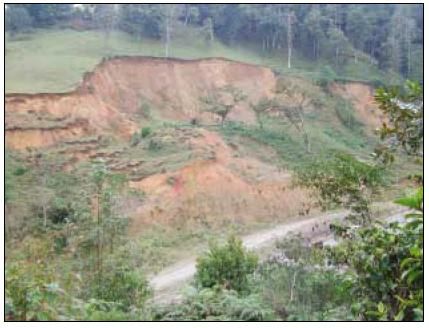
contaminated and it is possible Massive landslides were triggered by Mitch in Honduras and
that food shortages will occur. Guatemala
Casualties and Public Health
There are relatively few deaths associated with the impact of high winds. However, storm
surges may cause many deaths but usually few injuries among survivors. The threat to
public health emerges in the aftermath of events when conditions such as water
contamination or shortages, flooding and damage to sanitation facilities may favour the
spread of diseases.
Lack of Communication Communication may be severely disrupted as telephone lines,
radio and television antennas and satellite disks are blown down. Roads and railway lines
may be blocked by fallen trees or debris and aircraft movements are curtailed for hours
after a cyclone.
6
National Hurricane Centre Mitch 1998 Preliminary Report (http://www.nhc.noaa.gov/1998mitch.html)
Disaster Information Kit for the Caribbean Media Page 20Measuring Hurricanes: The Saffir-Simpson Scale
The table below provides examples of damage and storm surge heights from hurricanes.
Central
Cat Pressure Winds Surge Damage
(millibars)
1 Greater than 74-95 3-5 ft MINIMAL
980 mph 1.0- Damage primarily to shrubbery, trees, foliage,
1.7 m and unanchored homes. No real damage to other
structures. Some damage to poorly constructed
signs. Low-lying coastal roads inundated, minor
pier damage, some small craft in exposed
anchorage torn from moorings.
2 979 – 965 96-110 6-8 ft MODERATE
mph 1.8- Considerable damage to shrubbery and tree
2.6 m foliage; some trees blown down. Major
damage to exposed mobile homes.
Extensive damage to poorly constructed
signs. Some damage to roofing materials of
buildings; some window and door damage.
No major damage to buildings. Coast roads and low-lying escape
routes inland cut by rising water 2 to 4 hours before arrival of
hurricane center. Considerable damage to piers. Marinas flooded.
Small craft in unprotected anchorages torn from moorings. Evacuation
of some shoreline residences and low-lying areas required.
3 964-945 111- 9-12 EXTENSIVE
130 ft Foliage torn from trees; large trees blown
mph 2.7- down. Practically all poorly constructed
3.8 m signs blown down. Some damage to roofing
materials of buildings; some wind and door
damage. Some structural damage to small
buildings. Mobile homes destroyed. Serious
flooding at coast and many smaller structures near coast destroyed;
larger structures near coast damaged by battering waves and floating
debris. Low-lying escape routes inland cut by rising water 3 to 5 hours
before hurricane center arrives. Flat terrain 5 feet of less above sea
level flooded inland 8 miles or more. Evacuation of low- lying
residences within several blocks of shoreline possibly required.
4 944-920 131- 13-18 EXTREME
155 ft Shrubs and trees blown down; all signs
mph 3.9- down. Extensive damage to roofing
5.6 m materials, windows and doors. Complete
failures of roofs on many small residences.
Complete destruction of mobile homes. Flat
terrain 10 feet of less above sea level
flooded inland as far as 6 miles. Major damage to lower floors of
structures near shore due to flooding and battering by waves and
floating debris. Low-lying escape routes inland cut by rising water 3 to
5 hours before hurricane center arrives. Major erosion of beaches.
Massive evacuation of all residences within 500 yards of shore
Disaster Information Kit for the Caribbean Media Page 21Central
Cat Pressure Winds Surge Damage
(millibars)
possibly required, and of single- story residences within 2 miles of
shore.
5 Less than 156+ 19+ ft CATASTROPHIC
920 mph 5.7+ Shrubs and trees blown down; considerable
m damage to roofs of buildings; all signs down.
Very severe and extensive damage to
windows and doors. Complete failure of roofs
on many residences and industrial buildings.
Extensive shattering of glass in windows and
doors. Some complete building failures. Small buildings overturned or
blown away. Complete destruction of mobile homes. Major damage to
lower floors of all structures less than 15 feet above sea level within
500 yards of shore. Low-lying escape routes inland cut by rising water
3 to 5 hours before hurricane center arrives. Massive evacuation of
residential areas on low ground within 5 to 10 miles of shore possibly
required.
Disaster Information Kit for the Caribbean Media Page 22Messages the media should give to the public
Emergency Action
Weather warnings – who warns?
The local meteorological service in association with the national disaster organisation, issue
advisories, watches, and warnings. These are broadcast via the local or national television
or radio stations.
When a cyclone is approaching your country the only authoritative and legal source of
information is your meteorological office – not the Internet, not the Weather Channel,
nor any foreign news weather service. Only your local meteorologist has the knowledge of
your local area and only they can issue a realistic and accurate forecast.
The Tropical Prediction Centre (TPC) in Miami is one of the eight Regional Specialized
Meteorological Centres (RSMC) of the World Meteorological Organisation (WMO). Through
international agreement, the TPC has responsibility within the WMO to generate and
coordinate tropical cyclone analysis and forecast products for twenty-four countries in the
Americas, Caribbean, and for the waters of the North Atlantic Ocean, Caribbean Sea, Gulf of
Mexico, and the eastern North Pacific Ocean. The TPC comprises three branches, one of
which is the National Hurricane Centre in Miami with which most Caribbean journalists are
familiar.
The hurricane centre issues a forecast of the broader picture but the local meteorologist
must forecast for his/her jurisdiction. Only the local meteorologist has the authority to raise
a watch or warning and not the National Hurricane Centre.
Advisories
Messages issued by the authorities about the formation, location, speed, direction, strength,
and potential threat that the system poses to land are normally issued every six hours - at 5
am and 11 am and again at 5 pm and 11 pm. Should the cyclone be close to land,
advisories are issued every three hours.
TYPES OF ADVISORIES ACTIONS PUBLIC SHOULD TAKE
Advisory or Bulletin On hearing an advisory or bulletin the public
should:
The terminology may differ according to each
Caribbean territory. An advisory or bulletin is just a Continue normal activities but stay tuned to radio
simple information note to let the public know of the and television for further messages.
development of a cyclone or disturbance which
they should monitor.
Watch On hearing a storm or hurricane watch, the
public should:
A “tropical storm watch” is issued by your local
meteorological office when it is possible that • Review emergency preparedness; requirements,
tropical storm conditions, including winds from 39 especially family emergency plans;
to 73 mph could pose a threat to a specific island • Continue to listen to weather advisories on radio;
or coastal area within 36 hours. • Be ready to take quick action in case of a
Warning;
A “hurricane watch” is issued for a specific island
Disaster Information Kit for the Caribbean Media Page 23You can also read