Dorsey Wetland Hub Habitat Assessment and Management Plan
←
→
Page content transcription
If your browser does not render page correctly, please read the page content below
Dorsey Wetland Hub
Habitat Assessment and
  Management Plan
                            July 2017

                 Prepared for Howard County, MD

 A companion to the Green Infrastructure Corridor Analysis, this
 document offers habitat management guidance for Dorsey
 Wetland Hub. Preparing habitat management plans was listed as a
 priority project in Howard County’s 2012 Green Infrastructure
 Network Plan. The first section is a Landowner Summary. The
 second section provides a general orientation to the Network, the
 concept of habitat value, and the primary stressors and threats to
 the Network hubs and corridors. It concludes with a brief menu of
 the most commonly recommended habitat improvement
 techniques. The final section describes existing conditions and
 identifies potential habitat enhancements for the Dorsey Wetland
 Hub.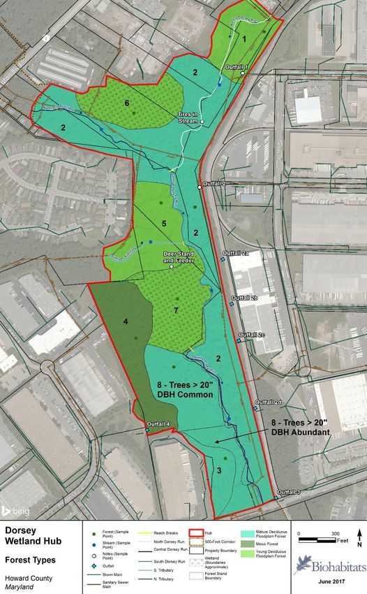
Table of Contents
Landowner Summary .................................................................................................................................... 1
Howard County Green Infrastructure Network .................................................................................... 1
Wildlife in Howard County.................................................................................................................... 1
What is Habitat? ................................................................................................................................... 2
Existing Conditions in Dorsey Wetland Hub ......................................................................................... 3
Dorsey Wetland Hub – Potential Enhancements ................................................................................. 4
Further Information .............................................................................................................................. 5
Habitat Management in Howard County ...................................................................................................... 6
Green Infrastructure Network .............................................................................................................. 6
Defining Habitat Value .......................................................................................................................... 8
Primary Stressors and Threats ............................................................................................................ 12
Common Habitat Enhancements ........................................................................................................ 18
Habitat Assessment Purpose and Methods........................................................................................ 27
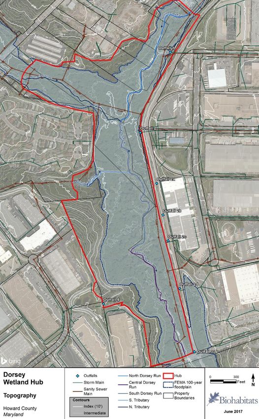
Dorsey Wetland Hub ................................................................................................................................... 30
Dorsey Landscape Context ................................................................................................................. 30
Dorsey Site Features ........................................................................................................................... 31
Current Management ......................................................................................................................... 42
Primary Threats and Recommendations ............................................................................................ 42
Secondary Threats and Recommendations ........................................................................................ 46
Glossary of Terms ............................................................................................................................... 48
i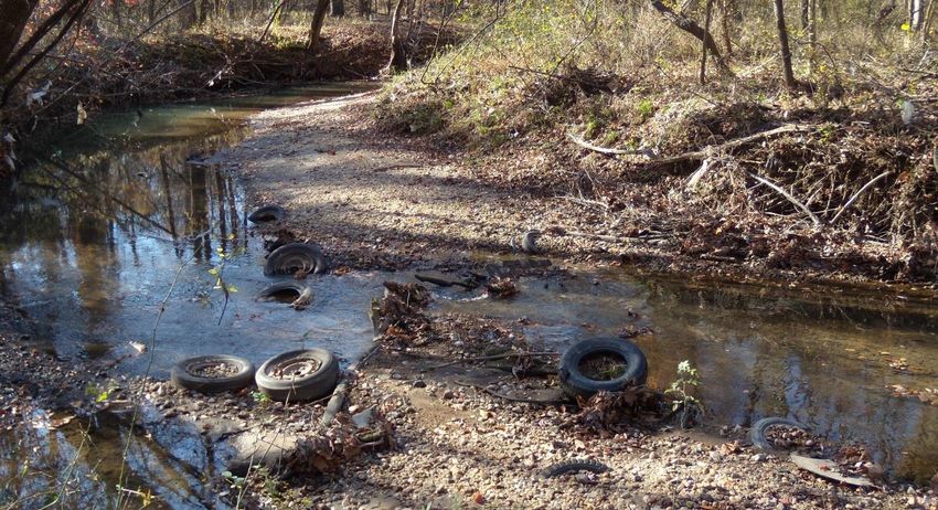
Green Infrastructure Network                                                                                                                  July 2017
Dorsey Wetland Hub Habitat Assessment and Management Plan

Figures, Tables, and Photos
Figure 1. Howard County Green Infrastructure Network ............................................................................. 7
Figure 2. A forest with vertical structure. ................................................................................................... 10
Figure 3. Connected landscapes ................................................................................................................. 13
Figure 4. Natural hydrological flows and altered flows after development ............................................... 15
Figure 5. Reconnecting a stream to its floodplain ...................................................................................... 21
Figure 6. Enhancing the habitat provided by ponds and wetlands. ........................................................... 23
Figure 7. Crown Position Classes ................................................................................................................ 28
Figure 8. Dorsey Wetland Hub .................................................................................................................... 31
Figure 9. Dorsey Wetland Hub Topography................................................................................................ 33
Figure 10. Dorsey Wetland Hub Soils.......................................................................................................... 34
Figure 11. Dorsey Wetland Hub Community Types .................................................................................... 35

Table 1. Non-native Invasive plant species observed at Dorsey Wetland Hub. ......................................... 47

Photo 1. Restored and mowed pond edges ............................................................................................... 14
Photo 2. Effects of overpopulations of deer ............................................................................................... 17
Photo 3. Fresh beaver sign observed in Forest Stand 2. ............................................................................. 32
Photo 4. Representative young deciduous floodplain forest along the sewer right-of-way...................... 36
Photo 5 Representative mature deciduous floodplain forest along the sewer right-of-way ..................... 37
Photo 6. Representative mesic forest ......................................................................................................... 38
Photo 7. North Dorsey Run at confluence with Outfall Channel 1 ............................................................. 38
Photo 8. Central Dorsey Run backwatered by beaver dam ........................................................................ 38
Photo 9: South Dorsey Run ......................................................................................................................... 40
Photo 10. Outfall 1 draining to North Dorsey Run...................................................................................... 41
Photo 11. Outfall 2 draining to top of Central Dorsey Run ......................................................................... 41
Photo 12. Outfall 3 draining to South Dorsey Run. ..................................................................................... 41
Photo 13. Outfall 4 draining to South Dorsey Run. ..................................................................................... 41
Photo 14. Outfall 2c. ................................................................................................................................... 42
Photo 15. Outfall 2d, with silted channel backwatering the pipe. ............................................................. 42
Photo 16: Trash in North Dorsey Run ......................................................................................................... 45

List of Appendices
Appendix 1: Habitat Assessment Data Sheets
Appendix 2: Hub Vegetation Inventories

                                                                                                                                                          ii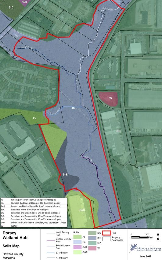
Green Infrastructure Network                                                                   July 2017
Dorsey Wetland Hub Habitat Assessment and Management Plan

Landowner Summary
This Landowner Summary is intended to give landowners within and adjacent to the Dorsey Wetland
Hub a brief introduction to the Howard County Green Infrastructure Network and the concept of habitat
value. A summary is then given of existing conditions within the hub and the primary and secondary
actions needed to improve those conditions to enhance the hub’s habitat value. A reference section at
the end of the summary provides links to sources for information on implementation techniques and
potential funding assistance. Landowners who wish to learn more about specific resource conditions or
enhancements listed in this summary will find more detailed information in the body of the Habitat
Management Plan.

Howard County Green Infrastructure Network

  The Network includes two basic building blocks:
    ▪ Hubs - large, natural areas, including forests and wetlands, which
       provide core habitat for native plants and animals
    ▪ Corridors – provide natural connections between hubs, often along
       rivers and streams, and allow wildlife to move safely and freely
       between hubs.
The Network offers multiple benefits for our communities and economy, including habitat for a variety
of native plants and animals, opportunities for nature-based recreation, cleaner air and water, reduced
storm runoff, and disrupted urban heat islands. The Network includes both public and privately owned
land, so a shared sense of stewardship among landowners, no matter how large or small their property,
is a critical asset in supporting a healthy Network.

Wildlife in Howard County
Howard County is home to familiar backyard wildlife, such as deer, rabbit, gray squirrel, woodchuck,
skunk, raccoon, opossum, fox, and coyotes that coexist within the patchwork of urban and suburban
land uses. The County’s more secretive residents, such as long-tailed weasel, river otter, mink, flying
squirrel, two species of bat, eleven species of salamanders, and an occasional black bear, have more
specific habitat requirements that require blocks of high quality habitat in the woods and along streams
and rivers. In addition to the resident wildlife, the Howard County Bird Club has documented over 200
species of migratory birds using the diverse habitats throughout the County for nesting or staging areas
along their migration. The most sensitive of the County’s wildlife are forest interior dwelling species,
which require large blocks of forest (>50 acres) with 10 or more acres of forest interior (more than 300
feet from the forest edge). Overall, the abundance and diversity of wildlife throughout the County also
supports various recreational and economically beneficial activities including birdwatching, hunting of
deer, waterfowl and upland gamebirds (e.g., American woodcock, mourning dove), and fishing.

                                                                                                       1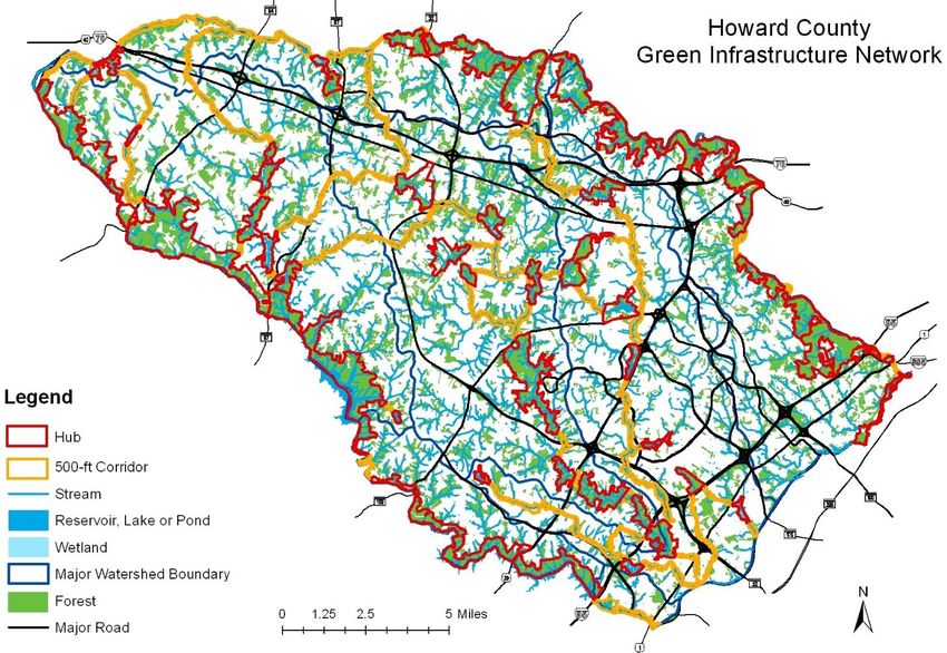
Green Infrastructure Network                                                                       July 2017
Dorsey Wetland Hub Habitat Assessment and Management Plan

A complete list of wildlife species in the County can be derived from the Maryland Biodiversity Project.
In order to establish habitat management and connectivity goals, the requirements of forest interior
species and the County’s 24 amphibians, 30 reptiles and 20 small mammals are a better guide than the
needs of highly mobile species such as migratory neotropical birds. Additional lists of threatened and
sensitive local wildlife, which can factor into management goals, are available from US Fish and Wildlife
Service and the Maryland Department of Natural Resources Wildlife and Heritage Service.

What is Habitat?                                                                          FOOD
Habitat is simply the area where a plant or animal makes its home and
accesses the resources necessary to live. Each species has different
habitat requirements, which can be defined in terms of the four
                                                                               SPACE                 WATER
resources that must coexist for plants and wildlife to live and thrive in
a specific location: food, water, cover, and space. The greater the
amount and variety of each of these resources, the more valuable the
                                                                                          COVER
habitat is for a wider range of species. Accordingly, the habitat value of a
property can be improved by the following:

    •   Food: Provide a variety of food sources
            o   Food provides the sustenance and nutrition animals and plants need to survive and
                reproduce. For plants, it may be a certain set of nutrients and the availability of sunlight.
                For animals, it may be a selection of native plants, insects, or other smaller animals.
                Good habitat provides a variety of abundant food sources to accommodate a wide
                range of species year-round. Property owners and managers are most likely to increase
                food sources for wildlife by planting or protecting the native plants that provide food in
                the form of foliage, nuts, fruits, seeds, nectar and pollen.
    •   Water: Provide and protect clean sources of water
            o   Water is a basic element for survival shared by all species, both as a source of hydration
                and as a home for all or a portion of a species’ life cycle. Plants and animals need a
                variety of clean water sources, which can be available in the form of soil moisture,
                groundwater, vernal (or seasonal) pools, ponds, wetlands and streams.
    •   Cover: Provide a variety of cover
            o   Wildlife need places to hide, rest, raise their young and take shelter from the weather.
                Depending on the species, cover can be found in rock or brush piles, downed logs,
                thickets, shrubs or trees. Forests, streams, wetlands, ponds and meadows with more
                structural diversity (vegetation in layers at differing heights) provide better cover.
    •   Space: Provide safe and appropriate space
            o   Plants and animals need safe and appropriate space that can accommodate their entire
                life-cycle, and space needs can vary by species and by life-stages within a species. By
                providing large, connected habitat areas, the Network is better able to accommodate
                the space needs of a variety of native species. Property owners within the Network can
                ensure their land continues to provide good quality habitat by protecting and enhancing
                the woods, meadows, wetlands and streams on their property.

                                                                                                            2
Green Infrastructure Network                                                                        July 2017
Dorsey Wetland Hub Habitat Assessment and Management Plan

Existing Conditions in Dorsey Wetland Hub
The Dorsey Wetland Hub is important to wildlife because it is a diamond in the rough. The hub is located
within a highly urban area in southeast Howard County in the vicinity of Dorsey Run Road, Route 1 and
the CSX railroad track. Contained within the hub’s approximately 78 acres are a mix of young and
mature deciduous forest, a large 100-year floodplain, wetlands, vernal pools, Dorsey Run and two small
tributaries to Dorsey Run. Land in the hub was likely cleared for farming and much of the forest is
dominated by similarly aged trees of roughly 12-20” diameter at breast height, which suggests that
clearing activity stopped about 50 years ago.

The forest and wetlands in the hub generally provide good habitat for the resident wildlife. There are a
variety of food and water sources, including oak trees that provide acorns. Abundant downed wood,
standing dead wood that host insects and grubs, and forests with layers of vegetation provide cover and
nesting habitat. The wet soils and deep shade make the hub excellent habitat for amphibians (frogs,
toads, newts, salamanders). Based on an informal, visual assessment, the instream habitat is supportive
of an aquatic community of fish, aquatic insects and other invertebrates. There are signs of beaver,
which is indicative of a robust wildlife population, and beaver create varied habitat and increase habitat
value for other species.

Although the hub is in reasonably good condition, it suffers from water management impairments
(storm drain outfalls and ditches), trash and an overabundance of deer. Conveying water in manmade
channels increases its velocity during storm events, which has erosive effects on the receiving stream
channel. The Dorsey Run stream channel is showing the erosive effects of unmanaged stormwater
runoff. Old drainage ditches drain water from the wetlands in Dorsey Wetland Hub, depriving them of
needed water and degrading the available wetland habitat. By draining the water directly to the
streams, rather than allowing it to filter through the floodplain soil, the ditches also have the net effect
of reducing water quality.

Notable amounts of trash and refuse were present throughout the hub: trash is washing downstream
from upstream properties, being dumped on site, and being discharged through adjacent stormwater
management facility outfall pipes. The trash includes tires and other large items such as automotive
parts.

A dense deer population browses the native understory and shrub layer heavily. The result is a forest
with a layer of tall canopy trees that the deer are unable to damage and an herbaceous groundcover
that the deer don’t eat. The deer’s destruction of the understory impedes forest regeneration, because
young trees are unable to grow to maturity and replace older, fallen or diseased trees.

Non-native invasive plants (NNIP) are present throughout the hub in low levels. These plants often have
prolific reproduction and growth rates, so they can out-compete native plants for water, nutrients and
space, yet rarely provide good food sources for native wildlife. Their presence is not currently a threat to
forest regeneration in the hub, but deer generally prefer to eat native plants over NNIP, which aids in
their spread.

                                                                                                               3
Green Infrastructure Network                                                                    July 2017
Dorsey Wetland Hub Habitat Assessment and Management Plan

Dorsey Wetland Hub – Potential Enhancements
There are several management techniques that could be implemented to improve habitat within the
hub. The primary actions needed to address the threats to habitat quality identified through this
assessment include: improve water management, create or support vernal pools, remove trash and
address the sources of this trash, and manage deer populations. Secondary actions to enhance habitat
quality could include installing bird and bat boxes or enhancing the forest and wetlands with
supplemental plantings of native species.

Techniques to address water management problems could include: blocking the ditches draining the
wetlands, creating vernal pools, retrofitting the adjacent stormwater management facilities to address
erosive flows and trash, and restoring stream channels. These activities would largely require the
assistance of environmental consultants and engineers to help evaluate and design any changes to site
hydrology and consequent changes to habitat. These professionals can model the effects of changing
the water flow and storing more water before it reaches streams. They can also ensure that the proper
local, state and federal permits are acquired.

To address trash coming from upstream properties, the County has completed and is pursuing zoning
violations against upstream property owners to remove trash and other materials from the floodplain.
In addition, the Department of Recreation and Parks has held annual spring cleanups along this section
of Dorsey Run. Trash dumping can be a difficult problem to address when the property owner cannot
directly monitor access points for dumpers, but property owners can begin by posting their property
with no dumping signs and reporting problems when they are observed. Adjacent landowners can
monitor their individual properties to ensure that the trash is picked up and disposed of properly so it
doesn’t blow around or end up in the stormwater management facility.

Techniques to manage deer populations for the hub include fencing and hunting. Fencing the entire hub
would be expensive, require each property owner to participate, and have negative effects on Network
connectivity. In addition, the fence would need ongoing maintenance to be effective. Managed deer
hunts may be possible with property owner permission within portions of the hub that meet setback
requirements for firearm and bow and arrow use.

Additional management actions could also enhance the habitat value of the site, including most of the
Common Habitat Enhancements in the second section of this document. Because such activities are not
responding to specific, urgent threats, selecting among them would largely depend on the interest and
energies of the landowners or other stakeholders. One of the best ways for a landowner to take a
structured approach to selecting additional habitat enhancements would be to initiate a Forest
Stewardship Plan with the Maryland Department of Natural Resources.

                                                                                                           4
Green Infrastructure Network                                                                  July 2017
Dorsey Wetland Hub Habitat Assessment and Management Plan

Further Information

Howard County Resources and Programs
 • The Stream ReLeaf Program provides free trees for stream buffer plantings
   (https://www.howardcountymd.gov/ Forestry).
 • The Howard Soil Conservation District (HSCD) supports several residential landowner programs such
   as Backyard Actions for a cleaner Chesapeake Bay
   http://mda.maryland.gov/resource_conservation/Documents/backyard.pdf. The HSCD also assists
   agricultural landowners with federal and state cost-share programs for habitat improvements,
   including the Environmental Quality Incentives Program (http://www.howardscd.org/cost-share )
 • The Howard County Deer Management Plan further explains the causes, problems and solutions to
   overabundant deer populations.
 • The Clean Water Howard stormwater management program provides information on managing
   water resources on private land http://www.cleanwaterhoward.com/

Additional Resources
   •   The Woods in Your Backyard is a state program that teaches forest management techniques to
       property owners with small forest acreage
       (https://extension.umd.edu/sites/default/files/_docs/WBYCreatingNaturalAreas.pdf ).
   •   The Maryland Department of Natural Resources (MD DNR) provides overview information on
       invasive species (http://www.dnr.state.md.us/invasives/).
   •   MD DNR Forestry Division supports TREE-mendous Maryland, which provides free trees for
       planting on public lands (http://dnr2.maryland.gov/forests/Pages/treemendous/default.aspx).
   •   The MD DNR Forestry Division provides information on a variety of forest stewardship programs
       (http://dnr2.maryland.gov/forests/Pages/programapps/stewcon.aspx) and can prepare Forest
       Stewardship Plans for individual properties for a modest fee.
   •   Wildlife habitat certification programs, such as MD DNR Wild Acres, the National Wildlife
       Federation and the Wildlife Habitat Council, work with residential, school and commercial
       property owners (http://dnr2.maryland.gov/wildlife/Pages/habitat/wildacres.aspx).
   •   The USDA has an excellent resource on how to create vernal pools:
       www.watershedconnect.com/documents/science_management_interventions_wetlands
   •   The US Fish and Wildlife Service provides a guide to native plants Native plants for Wildlife
       Habitat and Conservation Landscaping: Chesapeake Bay Watershed
   •   The Maryland Native Plant Society provides guidance on buying native plants, including a list of
       local nurseries that sell native plants, at http://mdflora.org/forgardeners.html
   •   The University of Maryland Extension provides information on a variety of homeowner and
       agricultural landowner programs (http://extension.umd.edu/). The Extension’s Home and
       Garden Information Center gives an overview of invasive insects and pests
       (https://extension.umd.edu/hgic/invasive-insects-0 ).
   •   The National Park Service provides a guide to identify and manage invasive plants - Plant
       Invaders of Mid-Atlantic Natural Areas, 4th ed. (Swearingen et. al. 2010) – that includes
       information on native plant alternatives
       (https://www.nps.gov/plants/alien/pubs/midatlantic/index.htm).
   •   The Nature Conservancy provides a guide for the control of invasive species - Herbicide Use in
       Natural Areas (TNC, 2010)
       http://www.nature.org/ourinitiatives/regions/northamerica/unitedstates/illinois/il-vsn-
       herbicide-use-manual-updated-2011.pdf .

                                                                                                      5
Green Infrastructure Network                                                                      July 2017
Dorsey Wetland Hub Habitat Assessment and Management Plan

Habitat Management in Howard County

Green Infrastructure Network
In 2010, Howard County made a formal
                                                     What is Green Infrastructure?
commitment to enhancing and supporting its
Green Infrastructure Network and the plants,         Although Green Infrastructure is sometimes
animals and resources it contains, as well as        used in a narrow sense to refer to stormwater
fortifying the ecological functions, such as         management, Howard County’s Green
water storage or pollinator services, that it        Infrastructure Network is based on the original
provides to sustain the health and quality of life   use of the term, as an ecological system on a
in the County. The County started by defining        scale comparable to other forms of urban
the geography of the Network, with attention         infrastructure (for example, road networks or
to providing connectivity with Networks in the       water and sewer systems), but composed of
state and in neighboring counties (Figure 1).        interconnected waterways, wetlands, forests,
The Howard County Green Infrastructure               meadows and other natural areas. A Green
Network, as originally defined in the 2012           Infrastructure Network with healthy resources
Howard County Green Infrastructure Network           offers multiple benefits for our communities
Plan, includes two basic building blocks: hubs,      and economy, including habitat for a variety of
which are large, natural areas that provide          native plants and animals, opportunities for
habitat for native plants and animals, and the       nature-based recreation, cleaner air and water,
corridors that connect them, often along rivers      reduced storm runoff and forest that disrupts
and streams.                                         urban heat islands.
Hubs contain large areas of interior forest and wetlands. Interior forest is generally defined as forest
found at least 300 feet from the forest edge and offers higher quality forest habitat, because it is
generally more isolated, with a closed canopy that creates moist, shaded growing conditions. Forest
interior habitat is also rare, especially in the south and east of the County, because development has
fragmented or broken up our remaining forest into ever smaller forest patches.

Hubs were defined to meet the following criteria:

    •   Interior forests of 50 acres or more with a 300-foot buffer
    •   Wetlands of 25 acres or larger, including ponds, lakes and reservoirs, with a 100-foot buffer
    •   State and County parkland and open space that contain these interior forests and wetlands
    •   Forest, parkland and open space immediately adjacent to these areas

The 51 hubs in the Network include over 20,000 acres, or 14% of the total County area, and range in size
from 25 to 2,407 acres. The hubs include major state and county parks as well as other public lands, but
almost 28% of the land is privately owned, which creates an important opportunity to support
stewardship and good habitat management or acquire easements or land.

                                                                                                           6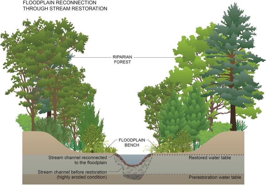
Green Infrastructure Network                                                                   July 2017
Dorsey Wetland Hub Habitat Assessment and Management Plan

Corridors link the hubs via narrow strips of forest or natural habitat that generally follow rivers and
streams. The Green Infrastructure Network defined two minimum corridor widths of 300 and 500 feet,
with extensions to include adjacent floodplain, wetlands, parkland and open space. The 500-foot
corridor width is the preferred option for the Network. However, there are areas within the Network
where a 300-foot corridor may be more appropriate, such as on agricultural land. There are 48 corridor
connections in the Network, and the 500-foot corridor system contains just over 6,000 acres or 4% of
the total County area. The corridors are ecologically important because they serve as physical links
among easements, parks, and large blocks of valuable habitat that may not be protected.

Figure 1. Howard County Green Infrastructure Network

Howard County Green Infrastructure Network Goals
The purpose of Howard County’s Green Infrastructure Network Plan is to define, protect and enhance a
Green Infrastructure Network that includes and links the most ecologically significant natural areas in
Howard County. The Green Infrastructure Network Plan outlines two overarching goals, one for habitat
and one for stewardship, each with supporting objectives.

                                                                                                          7
Green Infrastructure Network July 2017
Dorsey Wetland Hub Habitat Assessment and Management Plan
Habitat Goal: Protect, enhance and restore the habitat and natural areas within the Green
Infrastructure Network to support a diversity of plant and animal life.
Habitat Objectives:
• Retain, enhance and restore forests, interior forests and wetlands.
• Increase the habitat value of ponds, lakes and reservoirs.
• Enhance and restore stream habitat.
• Manage wildlife to support healthy and diverse populations of native species.
Stewardship Goal: Promote stewardship of the Green Infrastructure Network among individuals,
community organizations, businesses, schools and others.
Stewardship Objectives:
• Increase awareness and personal involvement.
• Encourage participation in land preservation programs.
• Promote land management practices that conserve resources, reduce pollution and enhance
habitat.
Hub Habitat Management Plans (or HMPs) help achieve both goals for the Network. The HMPs provide
information on existing habitat conditions and how to improve those conditions. This information is
useful for both public and private landowners who wish to improve habitat on their property. A shared
sense of stewardship among landowners is a critical asset in supporting a Network that provides habitat
for a diversity of native plant and animal life.
Defining Habitat Value
The Green Infrastructure Network provides an opportunity to enhance the quality of plant and wildlife
habitat at a scale much larger than an individual property. For the Network to function as a living
framework that shelters plants and wildlife and supports other ecological functions, it must provide both
high quality habitat and connectivity (see box on Page 12), so that plants and wildlife can move across
the landscape. Landscape in this context includes the physical elements of landforms such as hills and
meadows, water bodies such as rivers, lakes and ponds, living elements of land cover including
vegetation, human elements including different forms of land use such as agriculture, buildings and
roads, and transitory elements such as lighting and weather conditions.
Habitat value can be defined in terms of the four resources that must coexist for plants and animals to
live and thrive: food, water, cover, and space. The greater the amount and variety of each of these
resources, the more valuable the habitat is for a wider range of species. The following sections offer
general guidelines for meeting each of these four resource needs. Individual landowners can use this
information to evaluate their property for opportunities to enhance its habitat value. Specific
suggestions on how to do so begin in Common Habitat Enhancements (page 18).
8Green Infrastructure Network July 2017
Dorsey Wetland Hub Habitat Assessment and Management Plan
1. FOOD: Provide a variety of food sources
Each species has individual nutritional requirements, so good habitat provides a variety of abundant
food sources to accommodate a wide range of species.
Property owners and managers are most likely to improve feeding opportunities for wildlife by planting
or protecting the native plants that offer food to the widest variety of native wildlife species. Native
plants can provide food in the form of foliage, nuts, fruits, seeds, nectar and pollen. Native plants that
provide food for a variety of animals, including insects, birds, small mammals, amphibians and reptiles,
have the most habitat value. The US Fish and Wildlife Service (USFWS) publication Native Plants for
Wildlife Habitat and Conservation Landscaping: Chesapeake Bay Watershed is a useful general reference
for information on a wide variety of native plants that offer maximum wildlife value. Native plants have
the added value of being well adapted to local growing conditions, so they are more likely to survive and
require reduced maintenance once established. Including these plants in plantings can attract additional
wildlife species to a property.
2. WATER: Provide and protect clean sources of water
Plants and animals need a variety of clean water sources, which can range from soil moisture, dew,
rainfall, groundwater, vernal (or seasonal) pools, ponds, wetlands and streams. Water is needed by
wildlife for drinking, bathing, breeding and raising their young. Healthy wetlands and streams with
buffer areas of native vegetation support a host of wildlife species and complex plant communities, and
improve water quality and water storage. Where these diverse, undisturbed vegetated buffers are wider
than 15 feet along a stream or wetland, they also function as natural filter systems to clean surface
runoff before it enters the waterbody.
3. COVER: Provide a variety of cover
Wildlife need places to hide, rest, raise their young, and take shelter from the weather. Depending on
the species, cover can be found in rock or brush piles, downed logs, thickets, shrubs or trees. Forests,
streams, wetlands, ponds and meadows with more layers of vegetation at differing heights provide a
greater variety of cover and support more wildlife species.
Healthy forests with vegetative layers, or vertical structure, include well developed herbaceous, shrub,
understory and canopy layers (see Figure 2). Supplemental plantings to replace missing vegetative layers
can help improve forest habitat, as can allowing standing dead trees, or snags, to remain. Snags can
provide cavities for cavity-nesting birds such as many owls, chickadees, and woodpeckers and mammals
such as flying squirrels.
In streams, ponds, and wetlands, structural diversity is provided by having water of different depths and
flow speeds. Healthy streams provide a mix of fast and slow moving water at shallow and deep water
depths. In streams, structural diversity can be enhanced by wood or boulders that create complex cover
for refuge from predators or higher flows. Beavers, as natural architects of the aquatic landscape, create
a mosaic of habitats for other species, which thrive in the pools and wetlands they create. In ponds,
structural diversity is provided by benches of shallow habitat that provide areas for emergent and
aquatic vegetation to grow, create nursery areas for juvenile fish, and offer cover to escape predators.
9Green Infrastructure Network July 2017
Dorsey Wetland Hub Habitat Assessment and Management Plan
Figure 2. A forest with vertical structure includes herbaceous, shrub, understory, and canopy layers. The canopy
is comprised of the trees receiving direct sunlight, whereas other layers are fully or partially shaded.
Protected access to streams, ponds, and other water sources is a key part of cover. Animals that live all
or part of their lives in aquatic habitats and the wildlife that visit streams or ponds to drink prefer shelter
at the water’s edge. Ponds with more diverse natural vegetation along the edges provide a higher
habitat value than those with a manicured or mowed edge. Adding native vegetation to exposed or
mown pond edges and stream banks will introduce cover and structure in a way that will quickly
enhance wildlife habitat.
Meadows provide important cover for nesting, raising young, and escaping predators in addition to
ample seasonal forage, such as seeds and insects. On the east coast, meadows tend to naturally change
(in a process termed succession) to a forested system if left alone, so management is often necessary to
maintain an open meadow. Consequently, meadows are often mowed, which can have a profound
effect on the overall quality of the habitat. Mowing does suppress weeds and prevent succession;
however, mowing during peak nesting periods for wildlife (typically April through August) or too low to
the ground can disrupt wildlife breeding and brooding activities and decimate local populations for
ground nesting birds and mammals. Developing a mowing schedule can minimize the impacts of habitat
disruption, provide the necessary year-round cover for desirable native wildlife, and potentially
decrease the frequency and acreage that is mowed each year. Avoiding mowing altogether and
managing for “rewilded” landscaping can also add habitat value to a site, but may require more labor to
manage the growth of woody vegetation.
10Green Infrastructure Network July 2017
Dorsey Wetland Hub Habitat Assessment and Management Plan
4. SPACE: Provide safe and appropriate space
Plants and animals need safe and appropriate space that can accommodate their entire life-cycle and
provide food, water, and cover. Space needs can vary by species and by life-stage within a species. By
providing large, connected habitat areas, the Network is better able to accommodate the space needs of
a variety of native species. Property owners within the Network can ensure their land continues to
provide good quality habitat by protecting and enhancing the woods, meadows, wetlands and streams
on their property.
Easements are one way for property owners to ensure permanent protection of the resources on their
land. Easements may be donated or purchased, and are held by a local or state land trust. Local land
trusts in Howard County include the Rockburn Land Trust and the Howard County Conservancy, and the
state land trust is the Maryland Environmental Trust.
If a property is not yet developed, buildings, roads, driveways, gardens, and other site features can be
placed to optimize the space that remains. Site planning that minimizes the area of disturbance and
development, preserves large blocks or tracts of undisturbed habitat, minimizes the amount of edge
habitat where the forest abuts open or developed space, and maintains connections to adjacent habitat
can help maintain the habitat value of the Network.
Properties may sometimes contain plant or animal species that are in need of conservation and are
listed by the state as endangered, threatened or rare. An endangered species is defined by state law as
any species whose continued existence as a viable component of the state’s flora or fauna is determined
to be in jeopardy. A threatened species appears likely, within the foreseeable future, to become
endangered. A rare species or a species in need of conservation requires conservation measures for its
continued ability to sustain itself successfully. The Natural Heritage Program at the Maryland
Department of Natural Resources can provide guidance on conserving habitat for these species.
Species often become endangered, threatened or in need of conservation due to the loss or degradation
of their habitat. It is important to provide habitats that are rare in the landscape, when possible. In
Howard County, rare landscapes include forest interior, meadows, areas of low-growing shrubs and
trees, and cold-water streams.
Managing landscapes for habitat value and creating or maintaining rare habitats and recreating linkages
among habitat blocks improves biological diversity on a system-wide or regional scale. Biological
diversity is generally defined as the variability among living organisms from all sources, including
terrestrial, marine and other aquatic ecosystems, and the ecological complexes of which they are part;
this includes diversity within species, between species and of ecosystems.
11Green Infrastructure Network July 2017
Dorsey Wetland Hub Habitat Assessment and Management Plan
Primary Stressors and Threats
There are six primary threats to habitat quality that good management can help to address: loss of
habitat and habitat connectivity; property management activities; waste and contaminants; water
management impairments; wildlife community imbalance; and non-native invasive species. These
threats are discussed in more detail in the following section.
Loss of Habitat and Habitat Connectivity
The County’s landscape is a mosaic of habitats of varying value depending on land use. These range from
high-value interior forests to low-value parking lots.
Wildlife move most freely between habitats of Habitat Connectivity
similar value. For example, a forest interior dwelling
species such as a pileated woodpecker is more To conceptualize the significance of habitat
likely to move between patches of forest interior connectivity, imagine patches of habitat as
through patches of forest than across agricultural stepping stones across a stream channel. If the
fields. As the connections between like habitats stepping stones are large and close together, it
begin to break (a process called fragmentation), the is easy to walk across and your feet stay dry
value of both habitats begins to drop. The more (high connectivity). The risk of getting your feet
isolated a patch becomes from a core habitat such wet increases as the stepping stones get
as that found in a hub, the lower the value of the farther apart and/or smaller (fragmentation).
habitat. Over time, urban and suburban At a certain point, the stones do not appear to
development and agricultural activities have have any value in helping cross the stream, so if
fragmented habitats throughout the county, which you value dry feet, you can no longer cross the
has isolated plant and wildlife communities and stream. As patches of habitat for dry feet, small
made them more vulnerable to permanent local dry rocks are no longer of value (see Figure 3).
extinctions by disturbances such as flooding, fire or
strong wind storms.
Small patches of forest are not only compromised in terms of their extent, but also by the increased
amount of forest that is edge habitat. Forest edges, where the forest abuts open or developed space,
are hotter, drier, and more prone to being taken over by invasive species. Many native species cannot or
will not live near a forest edge, but instead require interior forest, with its cooler, moister and more
isolated habitat. Forest interior species are not adapted to the presence of species that live in edge
environments. Edge species can include cowbirds, crows, jays, opossums, raccoons, skunks and
domestic dogs and cats. These edge species are often predatory and can reduce the populations of
forest interior species such as low nesting birds. Songbirds, for instance, have greatly reduced nesting
success in forest edges because that is where brood parasites such as cowbirds are common. Brood
parasites lay their eggs in the nest of other birds, and the young intruders are fed by the host parents at
the expense of their young. Forest interior species may use habitat closer to the edge if the transition to
open space is gradual rather than an abrupt edge.
12Green Infrastructure Network July 2017
Dorsey Wetland Hub Habitat Assessment and Management Plan
Figure 3. Connected landscapes (A) generally have better habitat value than less connected ones (B). This
example shows a riparian corridor that has been fragmented by the loss of forest habitat. Credit: Biohabitats,
based on graphic by NRCS.
The Network is specifically designed to respond to the loss of habitat connectivity at the regional scale.
The County envisions a living Network of sites that allows animals and plants to migrate across and
through the landscape in corridors of high-quality habitat.
Property Management Activities
Every square foot of land has a potential habitat value – a rotting log can host dozens of invertebrates
(centipedes, potato bugs, slugs, etc.) which may feed a salamander, a milkweed plant in an urban
garden can sustain a handful of monarch caterpillars, a dead tree on the edge of the woods supports
invertebrates that are eaten by woodpeckers. Consequently, land management has a direct impact on
the abundance and diversity of wildlife inhabiting a space. Habitat values can be compromised by an
assortment of routine property management activities, especially if they are performed without
consideration for their effects on the ecological systems of a site. Mowing, clearing standing forest for
fields or agriculture, and dead tree removal can destroy breeding habitat, remove nesting sites, and
reduce the habitat value of a site by destroying cover and foraging opportunities. Other habitat
disturbances include unplanned foot trails or informal roads that can cause erosion and fragment
existing natural resource areas, as well as dumping trash, contaminants, or even yard waste. Of these,
mowing regimes are one of the easiest to alter and control for the benefit of wildlife.
Managing unused open areas for turf by regular mowing reduces available cover and food for local
wildlife populations. In addition to the cost of labor, fuel and equipment, regular mowing can have a
profound influence on plant and animal diversity. Mowing too frequently, for example, halts the normal
successional processes by which a plant community develops and diversifies over time. Instead of
13Green Infrastructure Network July 2017
Dorsey Wetland Hub Habitat Assessment and Management Plan
allowing a gradual addition of low-growing woody plants, mowing favors grasses, homogenizes plant
heights, and keeps the overall habitat complexity very low, which means limited nesting sites and food
sources. The loss of cover is especially important at habitat transitions such as water and woodland
edges. Mowing close to ponds and streams directly compromises habitat by forcing animals to access a
vital resource without the benefit of shade or cover for protection from predators. Mowing next to
ponds and streams also reduces the vegetative buffer that absorbs the overland flow of water during
rain events, which reduces water quality and thereby impairs aquatic habitat (see Photo 1).
Photo 1. A restored wetland (left) typically offers ample vegetation for cover at pond edges, whereas mowing to
the edge of a pond (right) reduces its habitat value.
Waste and Contaminants
Similar to humans, wildlife are sensitive to physical and chemical contaminants in their habitat,
especially those in water. Examples of materials hazardous to wildlife include glass, fishing line and
hooks, plastic bags and packaging, bottles, cans, and scrap metal. Fishing line can trap and/or constrict
limbs and necks, fishing weights can cause lead poisoning, and broken glass can cut feet. Small animals
can become trapped inside containers. Sea life often mistake floating plastic or balloons for food. The
plastic mesh around a Christmas tree or on erosion control products and even plastic rings for six-packs
can entangle and entrap wildlife, leaving them exposed and vulnerable to the elements or predators.
Contaminants of concern in improperly disposed of trash include household, automobile, and personal
care products, including pharmaceuticals, and pesticides. These can suppress animal immune systems,
disrupt reproduction, cause mutations, change how animals try to avoid predators, and disrupt thyroid
function, which controls metabolism. The higher an animal is in the trophic structure (food chain) of a
community, the more likely it is to ingest contaminants. For example, a bald eagle is much more
susceptible than a chickadee, because of the accumulation of toxins through the food chain. Aside from
being a threat to wildlife health and safety, trash is an aesthetic and structural intrusion on the
landscape, occupying space that would otherwise have ecological function.
14Green Infrastructure Network July 2017
Dorsey Wetland Hub Habitat Assessment and Management Plan
Water Management Impairments
Naturally vegetated areas such as meadows and forests allow stormwater or runoff from rainfall and
snowmelt to flow across the ground and filter slowly through the soil and vegetation before entering
nearby waterways. Often the majority of natural flow paths are below the surface in the groundwater.
This ensures the waterways receive a steady supply of cool, clean water. As land use changes, these
natural flow pathways are disrupted and threaten plants and wildlife by altering the availability of water.
With an increase in impervious cover from buildings, roads, and parking lots, stormwater cannot
infiltrate into the ground to reach nearby streams and wetlands (see Figure 4). Instead, the stormwater
rushes across the pavement, washing pollutants such as oil, pesticides and salt into nearby storm drains.
In older developed areas, this stormwater may be discharged directly to nearby streams through ditches
or pipes, which release a torrent of warm, polluted water that erodes banks and the bottoms of the
stream channels, dislodging and displacing aquatic life.
Figure 4. Natural hydrological flows (left) and altered flows after development (right). Credit: Biohabitats.
When unmanaged runoff causes stream channels to cut down or incise and erodes soil from the stream
banks, streams cannot easily overflow onto the adjacent floodplain at times of high storm flows. In
contrast, most healthy stream systems can readily overflow their banks during storms onto broad
floodplains that absorb or at least temporarily hold much greater quantities of water. This is an
important function in systems that are subject to flooding, because the floodwaters cause less channel
erosion, and sediment and pollutants can settle out of the floodwaters onto the floodplain.
Wetlands can also be damaged by polluted stormwater discharges and changes to their water regime. In
the past, ditches or swales were dug in wetlands to quickly drain water and allow the land to be farmed.
Plugging or filling these ditches can help restore normal water flows within the wetland.
15Green Infrastructure Network July 2017
Dorsey Wetland Hub Habitat Assessment and Management Plan
Streams and wetlands also reflect upstream conditions within their watershed and even continue to do
so through time. Some legacy issues such as past land clearing and development with poorly managed
stormwater continue to affect downstream stream and wetland health and the diversity of plants and
wildlife they support.
Stormwater management has been required in Howard County since 1984, and over time, management
measures have improved to better treat the quantity and quality of the stormwater discharging to
nearby streams. More recent changes to stormwater management requirements now specify methods
of treatment that include onsite retention and infiltration through vegetation and soil to greatly reduce
the volume, speed, and contamination of runoff.
Wildlife Community Imbalance
A healthy wildlife community is one where available resources (food,
Dynamic equilibrium
water, cover, space) can sustain the community in dynamic equilibrium
over time. Wildlife community imbalance occurs when one or more The concept of dynamic equilibrium
species knock an ecosystem out of balance through overconsumption or is similar to a checking account.
displacement of other species, or disruption of other key habitat Resources (money) come in and
features. This is often associated with the presence of non-native resources are consumed (bills).
invasive species, which outcompete or simply outnumber the native Sometimes there is a little more
species and disrupt the balance of the system. Sometimes, however, the money at the end of the month and
imbalance can occur with a native species whose control mechanisms sometimes a little less, but on
have been disrupted or removed. average there is enough. If consumed
One striking example of a wildlife community imbalance in Howard resources exceed the incoming
County and throughout central Maryland is the overpopulation of native resources for too long, the system
white-tailed deer relative to the space available to support them, which becomes stressed. Over time a new
is due to both habitat loss and to the elimination of natural apex or top equilibrium may need to be
predators (wolves and mountain lions). These deer thrive in edge established based on fewer or
habitat, eat vegetation in farm fields and suburban gardens, endanger different resources (for example,
drivers on our roadways, and serve as a reservoir for ticks and insect- need to shift from eating rabbits to
borne diseases. mice).
Overabundant deer populations are also having a negative impact on our remaining forests and other
natural areas, reducing the populations of many native plants and compromising habitat for a variety of
other animals. One of the critical habitat impacts from deer is effects on forest regeneration. Forests in
which too many tree seedlings are consumed by deer may become unable to regenerate and develop a
stratified vertical structure wherein only the largest canopy trees and an herbaceous groundcover are
able to persist (see Photo 2).
16Green Infrastructure Network July 2017
Dorsey Wetland Hub Habitat Assessment and Management Plan
The overabundance of deer is simply one symptom of a larger problem. White-tailed deer are
overabundant because they have less competition from other browsers and no natural predators left in
this region. Disruption of these natural systems of predation and competition is a problem that is not
limited to deer. The effects of other imbalances may be less apparent but they are pervasive, and some
cause additional problems for humans. For instance,
where wetland habitat is degraded or the patch of
land is too small to support healthy populations,
there might be few or no frogs and salamanders to
consume insect larvae, and pests such as mosquitoes
are more likely to flourish in puddles and standing
water.
Non-Native Invasive Species
Globalization and the easy transport of plants and
animals across oceans and over great distances has
resulted in the introduction of non-native invasive
plants (NNIP) that compete with native plant species.
Photo 2. Overpopulations of deer can damage plant
According to the Invasive Plant Atlas, over 1,200 NNIP communities and prevent forest regeneration. Rubbing (L)
are present in natural areas of the US. These non- and browsing young plants (R) prevents them from reaching
native invasive species are sometimes heartier than maturity. Credit: Biohabitats.
natives during times of disturbance and they often
have prolific reproduction and growth rates, so they compete with native plants for water, nutrients and
space and can even displace the more valuable native plants. NNIP often do not provide the same
habitat value as native plants, because they do not provide the same food sources for native wildlife.
Historically some plants were introduced to help prevent soil erosion on public lands before it was
understood how destructive they could be in native ecosystems. Disturbed and fragmented habitat
patches are especially susceptible to competition from invasive plant species, whereas robust and
diverse native plant communities are better able to resist them. Pro-active management of the
vegetation in a hub or corridor can reduce the likelihood of it becoming overtaken by invasive plants.
Property owners should take care not to introduce or plant NNIP, such as English ivy, bamboo, butterfly
bush, Bradford or Callery pear and Norway maple, which are commonly sold at garden centers. Plant
Invaders of Mid-Atlantic Natural Areas, published by the USFWS, is an excellent general reference for
learning how to identify and control NNIP.
Damaging invasive species can include various types of organisms, and introduced invertebrate pests are
among the most harmful. The Emerald Ash Borer (EAB), for example, which appeared in the US in 2002,
has required treatment, removal, and replacement of affected native ash trees that has cost over 10
billion dollars according to the US Department of Agriculture (USDA) Forest Service estimates. This
invasive, non-native insect species destroys native ash trees when their larvae burrow and feed in the
ash bark, eventually damaging the tree’s ability to transport moisture and nutrients from the soil to the
tree’s leaves, causing the tree’s decline and death. The EAB is beginning to be an issue for all ash tree
species in the region, creating an imbalance in the makeup of regional forests and removing important
17Green Infrastructure Network July 2017
Dorsey Wetland Hub Habitat Assessment and Management Plan
habitat for other native wildlife species. This has happened previously in our forests, when the native
American Chestnut and American Elm were decimated by the chestnut blight and Dutch elm disease,
respectively, both accidentally introduced fungal diseases. The gypsy moth and Asian long-horned
beetle are other common and damaging invasive species in our forests. The European starling was
introduced to New York's Central Park in the early 1890s and now competes with our native birds for
nesting cavities. The northern snakehead fish that was introduced from Asia is a voracious predator that
is disrupting natural food webs. Further information on invasive species is available from the University
of Maryland Cooperative Extension.
Common Habitat Enhancements
Many properties within the Network could benefit from habitat improvements. A variety of techniques
can be used to improve a property’s ability to provide food, water, cover and space. Because hubs were
identified according to the natural features and without regard to property ownership, private
landowners have an important role to play in the management of their habitat value, both for the land
they own that falls directly within hubs and as “good neighbors” to the hubs. Landowners can
sometimes make simple changes in property management that will save them time and money and
increase their property value, while also increasing habitat quality. There are several techniques that are
broadly applicable to most properties within the Network:
▪ Adjust mowing schedules and strategies
▪ Install bat boxes and bird houses
▪ Remove trash and contaminants
▪ Manage stormwater and restore natural flow patterns
▪ Enhance ponds and wetlands
▪ Create and enhance vernal pools
▪ Manage deer populations
▪ Enhance forests with native species and vegetation management
▪ Manage non-native invasive plants (NNIP)
These techniques are discussed in general terms in the following sections and the Habitat Management
Plans for the individual hubs elaborate upon those that respond to specific threats in the hub. In
addition links to supplemental resources on implementation, maintenance and operation of the
techniques are embedded in applicable sections.
Adjust Mowing Schedules and Strategies
Hubs usually contain large wetlands and forests, so broad-scale mowing is not a common practice.
However, mowing is used in areas such as parks, near ponds and along shorelines and in neighboring
lands. The properties adjacent to hubs are critically important to the habitat connectivity that animals
experience as they move across a landscape, and mowing sometimes proceeds according to tradition or
routine rather than through consideration of the costs and benefits of the activity. Properly timed
mowing and rotational mowing can be used to stimulate growth of the native warm-season grasses and
18You can also read