Drilling at Eidsvold intersects strong alteration and mineralisation at Great Eastern Target
←
→
Page content transcription
If your browser does not render page correctly, please read the page content below
ASX ANNOUNCEMENT 31 May 2021
ASX: MBK
Drilling at Eidsvold intersects strong alteration and
mineralisation at Great Eastern Target
Highlights
Two additional holes completed for 954.3m as follow up to successful Queensland
Government CEI drilling grant work
Drilling intersected strong alteration zones and narrow high-grade mineralisation
returning 1m @ 0.25g/t Au, 139g/t Ag, 5.2% Pb-Zn and 0.12% Cu
Geology consistent with intrusion-related Au system and previous GET002 hole
confirming the location of the hydrothermal system west of the central intrusive
IP/resistivity line extends the open target area further west and at shallower target
depths
Further detailed geophysics now planned over an area of structural complexity to
the south of the completed drilling
Metal Bank Limited (ASX:MBK) (‘Metal Bank’, ‘MBK’ or the ‘Company’) is pleased to provide an
update on the exploration program at its Eidsvold intrusion-related gold project in Southeast
Queensland.
A follow-up drill program to the successful Collaborative Exploration Initiative Round 4 work
completed in December 1 has intersected further alteration and high grade precious and base metal
veining overprinting basement host rock, 1600m west of previous drilling. An additional
IP/resistivity geophysical line has extended the subsurface information on the system further west
and at shallower target depths. Work to date has defined the shallowing altered basement to the
west and confirmed the size of the hydrothermal system. Encouraging grades of precious and base
metal mineralisation were observed suggesting intersection of the outer part of the hydrothermal
system. The results have refined the bulk-tonnage target to the south-west margin of the intrusive
complex where an area of structural complexity is co-incident with a reverse-magnetised signature
and inferred magnetite destruction.
Commenting on the drilling at the Great Eastern Target, Metal Bank’s Chair, Inés Scotland said:
“The latest drilling and IP has provided further understanding of the location and depth of the
western target area identified in previous drilling. We are encouraged by the continued alteration
and the shallowing of the system towards the surface to the west. With the intersection of narrow
mineralisation and the support of IP extension of the target area, we are confident that we are on
the right track towards identifying a large intrusion related gold system at Eidsvold.”
1
MBK ASX Release dated 2 February 2021
Page |1 Metal Bank Limited ABN 51 127 297 170 Suite 506 Level 5 50 Clarence Street Sydney NSW 2000
Figure 1: Eidsvold Project targets and drill hole locations

Page |2
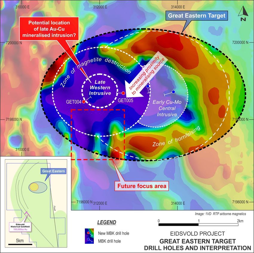
Figure 2: Great Eastern Target intrusion-related prospect schematic showing work and interpretation to date on magnetic imagery.

Great Eastern Target Extension Drill Program
Following successful identification of intrusion-related alteration and veining at the Great Eastern
Target as part of the Queensland Government’s Collaborative Exploration Initiative and subsequent
work, two additional PCD/DD holes for 954.3m were completed in April (GET004-5, Figures 1, 2 and
4). These holes targeted the western magnetic anomaly interpreted as the possible causative
intrusion for the intrusion-related Au and Cu-Mo mineralisation as intersected in GET002 2.

2
    MBK ASX Release dated 2 February 2021

Page |3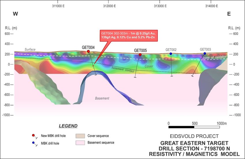
GET004 drilled 1600m west of GET002 intersected further alteration and narrow high grade precious
and base metal veining overprinting basement host rock. The basement of altered and weakly
veined variably hornfelsed quartz monzonite to monzodiorite (similar to GET002) was intersected
at 228m below cover sequence sediments. Sulphide-rich veining was intersected at 303-304m
(Figure 3) consisting of a moderately south-east dipping narrow quartz-pyrite-sphalerite-galena-
chalcopyrite vein with strong clay alteration halo returning 1m @ 0.25g/t Au, 139g/t Ag, 3.6% Pb,
1.6% Zn and 0.12% Cu (Figure 4). High accessory Bi (422ppm) and Sb (268ppm) is also present. Minor
narrow sheeted veinlets, phyllic alteration zones and propylitic (chlorite+/-epidote) altered
xenoliths were intersected to end of hole with anomalous Cu-Pb-Zn, Sb and Bi values. While a
causative intrusion for precious and base metal overprint of the early weak Cu-Mo porphyry style
system, as identified in the central area of the Great Eastern Target in previous drilling, was not
intersected, metal associations in the veins indicate marginal to intermediate position from the
intrusive metal source.

                                         HOST ALTERED QUARTZ MONZONITE

                                                                              galena
                                                          sphalerite
                      chalcopyrite
                                                                    pyrite                           quartz

                                          HOST ALTERED QUARTZ MONZONITE
                                                                           10cm

 Figure 3: Quartz-pyrite-sphalerite-galena-chalcopyrite vein within 303-304m interval returning 1m @ 0.25g/t Au, 139g/t Ag, 5.2%
                                                        Pb-Zn and 0.12% Cu

GET005 was drilled between GET004 and GET002 intersecting basement at 323m comprising
variably propylitic altered quartz monzonite/monzodiorite. Minor sheeted veining with phyllic
alteration selvedges were intersected throughout with a dominant southeast dip. No significant
assay results were returned.

Page |4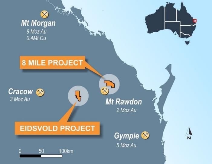
reverse-polarised
                                           elevated magnetic
                                                  high

          LOG Resistivity

                                            Inferred structure

Figure 4: Great Eastern Target 7198700mN +/-200m cross-section showing drilling, simplified geology and 3D magnetic model over
                                                pole-dipole resistivity model

IP survey extension
In addition to the drilling, a western extension of the existing Induced Polarisation (IP)/resistivity
line was conducted. This was aimed at continuing deep detection of electrical signatures
characteristic of altered zones in a Mt Leyshon-style system and to provide better reconciliation of
basement depths for favourable drill testing. Refer to Figure 4.
The response showed a clear shallowing of basement lithology to the west towards a large scale
western bounding structure (Figure 4), extending the open target area further west and at shallower
target depths.
Due to the deep and conductive cover sequence in the centre of the target area the basement
response was inconclusive, however, structural features were observed at the western edge of the
survey indicating a north-south trending fault.
The Company is encouraged by the continued growth of observed alteration and the shallowing of
the system to the west. Interpretation of the latest geological and geophysical data suggest the
possible causative intrusive/s may be coincident with the western bounding structure identified in
recent IP, structural orientations taken from drill core, zones of magnetite destruction and a
complex reverse-magnetic anomaly approximately 1km to the south of GET004.

Page |5
Forward Work Programs
A further work program for the Eidsvold project is being developed based on the results to include
additional detailed geophysics and structural analysis with the aim of fine targeting the location of
the causative intrusive/s prior to drilling.
In addition to the Great Eastern Target, the Eidsvold project area covers the historical Eidsvold
100,000oz goldfield and presents a number of additional targets with bulk tonnage potential.
Assessment of the historical goldfield for linkage to the Great Eastern Target is ongoing and
additional work is planned to assess other targets with the Eidsvold project area, including Mt Jones
and Tower Hill.
About Metal Bank
Metal Bank Limited is an ASX-listed minerals exploration company (ASX: MBK).
Metal Bank’s core focus is creating value through a combination of exploration success and quality
project acquisition. The company’s key projects are the 8 Mile and Eidsvold gold projects situated
in the northern New England Fold Belt of central Queensland, which also hosts the Cracow (3
Moz Au), Mt Rawdon (2 Moz Au), Mt Morgan (8 Moz Au, 0.4Mt Cu) and Gympie (5 Moz Au) gold
deposits. The projects are both associated with historical goldfields and represent intrusion related
gold systems (IRGS) with multi-million-ounce upside (Figure 7).
Figure 3: Location of Metal Bank Projects
Page |6The Company has an experienced Board and management team which brings regional knowledge,
expertise in exploration and project development, relevant experience in the mid cap ASX-listed
resource sector and a focus on sound corporate governance.
The Company is committed to a strategy of diversification and growth through identification of new
exploration opportunities which complement its existing portfolio and pursuit of other
opportunities to diversify the Company’s assets through acquisition of advanced projects or cash-
flow generating assets to assist with funding of the exploration portfolio.
In pursuit of this strategy, the Company is actively reviewing new opportunities within Australia with
a number of third parties under confidentiality arrangements. In addition, the Company is
continuing to work with government and stakeholders in the MENA region with a view to securing
an advanced copper exploration project.
Authorised by the Board
For further information contact:
Inés Scotland – Executive Chair
ines@metalbank.com.au
Sue-Ann Higgins - Director and Company Secretary
sue-ann@metalbank.com.au
Board of Directors and Management Registered Office
Inés Scotland Metal Bank Limited
(Non-Executive Chairperson) Suite 506, Level 5
50 Clarence Street
Guy Robertson Sydney NSW 2000
(Executive Director) AUSTRALIA
Sue-Ann Higgins Phone: +61 2 9078 7669
(Executive Director and Company Email: info@metalbank.com.au
Secretary)
Share Registry
Rhys Davies Automic Registry Services
(Exploration Manager) Phone: 1300 288 664 (local)
+61 2 9698 5414 (international)
Email: hello@automic.com.au
Trevor Wright Web site: www.automic.com.au
(Technical Advisor)
Please direct all shareholding enquiries to
the share registry.
Page |7Competent Persons Statement The information in this announcement that relates to Exploration Results, Mineral Resources and Exploration Target statements is based on information compiled or reviewed by Mr Rhys Davies. The Company is not aware of any new information or data that materially affects the information included in referenced ASX Releases and in the case of reported Mineral Resources, all material assumptions and technical parameters underpinning the estimates continue to apply and have not materially changed. Mr Davies is a Member of The Australasian Institute of Geoscientists and is a contractor to the Company. Mr Davies has sufficient experience which is relevant to the style of mineralisation and type of deposit under consideration and to the activity which he is undertaking to qualify as a Competent Person as defined in the 2012 Edition of the ‘Australasian Code for Reporting of Exploration Results, Mineral Resources and Ore Reserves’. Mr Davies consents to the inclusion in the announcement of the matters based on his information in the form and context in which it appears. The Exploration Targets described in this announcement are conceptual in nature and there is insufficient information to establish whether further exploration will result in the determination of Mineral Resources. Page |8
JORC Code, 2012 Edition – Table 1
           Section 1 Sampling Techniques and Data
           (Criteria in this section apply to all succeeding sections.)
Criteria           JORC Code explanation                                               Commentary

Sampling           • Nature and quality of sampling (e.g. cut channels, random         • PCD (polycrystalline composite bit), Reverse circulation (RC) and
                     chips, or specific specialised industry standard measurement        diamond (DD) drilling was used to obtain samples for geological
techniques
                     tools appropriate to the minerals under investigation, such as      logging and assaying.
                     down hole gamma sondes, or handheld XRF instruments,              • The drill holes were sited to test geophysical targets/surface
                     etc.). These examples should not be taken as limiting the           geochemical targets as well as previous drilling results
                     broad meaning of sampling.                                        • Diamond core was halved with a core saw through zones where
                   • Include reference to measures taken to ensure sample                alteration and veining was present and sampled at 1m intervals.
                     representivity and the appropriate calibration of any             • In barren country rock, diamond core was sampled 1m in every
                     measurement tools or systems used.                                  5m for waste rock characterisation.
                   • Aspects of the determination of mineralisation that are           • 1m RC samples were collected via a cyclone mounted rotary
                     Material to the Public Report. In cases where ‘industry             splitter for all samples.
                     standard’ work has been done this would be relatively simple      • No sampling was taken in overlying sediment except for the
                     (e.g. ‘reverse circulation drilling was used to obtain 1 m          preceeding 10 meters from the contact.
                     samples from which 3 kg was pulverised to produce a 30 g          • No sampling was taken for analysis was taken in PCD drilling due
                     charge for fire assay’). In other cases more explanation may        to previously defined barren cover sequence and
                     be required, such as where there is coarse gold that has            contamination.
                     inherent sampling problems. Unusual commodities or                • Where moderate to strong alteration was noted 1m samples
                     mineralisation types (e.g. submarine nodules) may warrant           were collected. In less altered samples the 1m samples were
                     disclosure of detailed information.                                 split to create a 4m composite sample for analysis and the
                                                                                         splitter cleaned with compressed air gun after each interval.
                                                                                       • RC and DD samples were submitted to the laboratory and
                                                                                         sample preparation consisted of the drying of the sample, the
                                                                                         entire sample being crushed to 70% passing 6mm and
                                                                                         pulverised to 85% passing 75 microns in a ring and puck
                                                                                         pulveriser. RC samples are assayed for gold by 50g fire assay
                                                                                         with AAS finish. Multielement analysis is completed using an
                                                                                         ICPAES analysis. Selective whole rock XRF was completed on
                                                                                         Great Eastern Target drill core.
Drilling           • Drill type (e.g. core, reverse circulation, open-hole hammer,     • PCD drilling using a 5.5” mud auger bit.
                     rotary air blast, auger, Bangka, sonic, etc.) and details (e.g.   • RC drilling used a 5.5” face sampling RC hammer.
techniques
                     core diameter, triple or standard tube, depth of diamond tails,   • Diamond drilling was all NQ drill diameter (Reflex core
                     face-sampling bit or other type, whether core is oriented and       orientation system utilised).
                     if so, by what method, etc.).                                     • Diamond holes were completed as tails to extend PCD and RC
                                                                                         holes.
Drill sample       • Method of recording and assessing core and chip sample            • For diamond core drilling core recoveries are measured by
                     recoveries and results assessed.                                    reconstructing core into continuous runs on an angle iron cradle
recovery
                   • Measures taken to maximise sample recovery and ensure               for orientation marking. An average core recovery of greater
                     representative nature of the samples.                               than 98% has been achieved.
                   • Whether a relationship exists between sample recovery and         • No additional measures were required as core recoveries are
                     grade and whether sample bias may have occurred due to              deemed to be high and samples considered to be
                     preferential loss/gain of fine/coarse material.                     representative.
                                                                                       • For RC sample recoveries of less than approximately 80% are
                                                                                         noted in the geological/sampling log with a visual estimate of
                                                                                         the actual recovery. Very few samples were recorded with
                                                                                         recoveries of less than 80%. No wet RC samples were recovered.
                                                                                       • No relationship has been observed between sample recovery
                                                                                         and grade.
                                                                                       • PCD sample was limited due to ground conditions and collected
                                                                                         where possible
Logging            • Whether core and chip samples have been geologically and          • Geological logging was carried out on all PCD (where sample
                     geotechnically logged to a level of detail to support               possible), RC chips and DD core. This included lithology,
                     appropriate Mineral Resource estimation, mining studies and         alteration, sulphide percentages and vein percentages.
                     metallurgical studies.                                            • Geological logging of alteration type, alteration intensity, vein
                   • Whether logging is qualitative or quantitative in nature. Core      type and textures, % of veining, and sulphide composition.
                     (or costean, channel, etc.) photography.                          • For diamond core structure type is recorded along with
                   • The total length and percentage of the relevant intersections       structural orientation data (alpha and beta measurements)
                     logged.                                                             where the drill core is orientated.
                                                                                       • All RC chip trays and all core trays are photographed.
                                                                                       • All drill holes are logged in full.

    Page |9
Criteria JORC Code explanation Commentary
Sub-sampling • If core, whether cut or sawn and whether quarter, half or all • 1m primary RC samples were obtained using a cyclone mounted
techniques core taken. 87.5%:12.5% riffle splitter. Compressed air was used to clean
• If non-core, whether riffled, tube sampled, rotary split, etc. the splitter after each drill rod.
and sample and whether sampled wet or dry. • 4m composite RC samples obtained by manually splitting 1m
preparation • For all sample types, the nature, quality and appropriateness primary samples with a standalone 87.5%:12.5% riffle splitter.
of the sample preparation technique. • Duplicated samples were collected in visual ore zones and at a
• Quality control procedures adopted for all sub-sampling frequency of at least 1 in 20.
stages to maximise representivity of samples. • Core is sawn in half with one half taken for sampling and the
• Measures taken to ensure that the sampling is representative other retained in core trays identified with hole number, meter
of the in situ material collected, including for instance results marks, and the down hole orientation line. Samples are
for field duplicate/second-half sampling. collected from the same side of the core.
• Whether sample sizes are appropriate to the grain size of the • A core saw is used for core to provide representative sub‐
material being sampled. samples. Industry standard sample preparation is conducted
under controlled conditions within the laboratory and is
considered appropriate for the sample types.
• For diamond core no duplicate or quarter core sampling was
completed as part of this programme.
• No samples were taken, prepared or submitted from PCD
drilling of barren cover sequence
• QAQC samples (standards / blanks) were submitted at a
frequency of at least 1 in 20. Regular reviews of the sampling
were carried out by the Exploration Manager to ensure all
procedures were followed and best industry practice carried
out. Sample sizes and preparation techniques are considered
appropriate.
• The sample sizes are considered to be appropriate for the
nature of mineralisation within the project area. Duplicate RC
sampling concentrated on potentially mineralised intervals.
Quality of data • The nature, quality and appropriateness of the assaying and • RC and DD samples were assayed using 50g fire assay for gold
and laboratory laboratory procedures used and whether the technique is which is considered appropriate for this style of mineralisation.
considered partial or total. Fire assay is considered total assay for gold.
tests • For geophysical tools, spectrometers, handheld XRF • No geophysical tools, spectrometers or handheld XRF
instruments, etc., the parameters used in determining the instruments have been used to determine assay results for any
analysis including instrument make and model, reading times, elements.
calibrations factors applied and their derivation, etc.. • Monitoring of results of blanks and standards is conducted
• Nature of quality control procedures adopted (e.g. standards, regularly. QAQC data is reviewed for bias prior to inclusion in
blanks, duplicates, external laboratory checks) and whether any subsequent Mineral Resource estimate.
acceptable levels of accuracy (i.e. lack of bias) and precision
have been established.
Verification of • The verification of significant intersections by either • Significant intersections are routinely monitored through review
sampling and independent or alternative company personnel. of drill chip and drill core and by site visits when possible, by the
• The use of twinned holes. Exploration Manager.
assaying • Documentation of primary data, data entry procedures, data • Data is verified and checked in Micromine software.
verification, data storage (physical and electronic) protocols. • No drill holes have been twinned.
• Discuss any adjustment to assay data. • Primary data is collected via ‘tough book’ laptops in the field in
self-validating data entry forms.
• Third party database integration and external storage is
undertaken using locked logging systems, with notification of
any issues
• Data is subsequently uploaded into a corporate database for
further validation/checking and data management. All original
files are stored as a digital record.
• No adjustments have been applied to assay data.
Location of • Accuracy and quality of surveys used to locate drill holes • Drill hole collar locations are initially set out (and reported)
data points (collar and down-hole surveys), trenches, mine workings and using a hand held GPS with a location error of +/‐ 5m. All holes
other locations used in Mineral Resource estimation. are pegged and will be accurately surveyed (x,y,z) at a later
• Specification of the grid system used. date.
• Quality and adequacy of topographic control. • Down hole surveys were completed using a Reflex Ez-Trac digital
survey system at a maximum interval of 30m. Measurements
are taken approximately 6m back from the RC hammer or
diamond bit at the mid point of a non-magnetic stainless-steel
rod to avoid magnetic interference
• Downhole surveys are not possible for PCD drilling however
surveys resumed when possible
• All drilling is conducted on the MGA94 Zone 56 grid.
P a g e | 10Criteria JORC Code explanation Commentary
• A detailed topographic survey of the project area has not been
conducted however airborne geophysical surveys have good
topographic control to sub 10m level.
Data Spacing • Data spacing for reporting of Exploration Results. • The drill holes were sited as either maiden drilling beneath
• Whether the data spacing and distribution is sufficient to sediment cover or as extensions drilling of known mineralisation
and
establish the degree of geological and grade continuity – currently ~600-1000m apart
distribution appropriate for the Mineral Resource and Ore Reserve • The current drill hole spacing is insufficient density to establish
estimation procedure(s) and classifications applied. geological and grade continuity appropriate for a Mineral
• Whether sample compositing has been applied. Resource.
• No sample compositing has been applied.
Orientation of • Whether the orientation of sampling achieves unbiased • The drill holes were orientated in order to intersect the
sampling of possible structures and the extent to which this is interpreted mineralisation zones as oblique (perpendicular) as
data in
known, considering the deposit type. possible based on information to date
relation to • If the relationship between the drilling orientation and the • Considered to be no sampling bias from drill hole structural data
geological orientation of key mineralised structures is considered to obtained on the project.
structure have introduced a sampling bias, this should be assessed and
reported if material.
Sample • The measures taken to ensure sample security. • Samples were stored in sealed polyweave bags on site and then
put into sealed bulka bags and transported to the laboratory at
security
regular intervals using either company vehicles or secure third
party logistics providers.
Audits or • The results of any audits or reviews of sampling techniques • The sampling techniques are regularly reviewed with no
and data. identification of issues to date.
reviews
P a g e | 11Section 2 – Reporting of Exploration Results
(Criteria in this section apply to all succeeding sections.)
Criteria JORC Code explanation Commentary
Mineral • Type, reference name/number, location and ownership • The Eidsvold project is within EPM18431, EPM18753 are all
including agreements or material issues with third parties 100% owned by Roar Resources Pty Ltd a wholly owned
tenement and
such as joint ventures, partnerships, overriding royalties, subsidiary of Metal Bank Limited.
land tenure native title interests, historical sites, wilderness or national The tenement is in good standing and no known impediments
status park and environmental settings. exist.
• The security of the tenure held at the time of reporting along
with any known impediments to obtaining a licence to
operate in the area.
Exploration • Acknowledgment and appraisal of exploration by other • Newcrest completed exploration activities including ground
parties. magnetic and regional spaced RC drilling (15 holes) in 1998 over
done by other
a portion of the project adjacent to the historical goldfield.
parties • All other exploration data and drill data presented was collected
by Metal Bank and Roar Resources Pty Ltd (a 100% subsidiary of
Metal Bank Limited).
Geology • Deposit type, geological setting and style of mineralisation. • EPM18431 and EPM18753 lie on the Eidsvold 1:100,000 map
sheet.
• The style of mineralisation intersected is intrusion related gold
mineralisation within the multiphase Eidsvold Intrusive complex
as a part of the northern New England Orogen and includes the
Eidsvold goldfield where 100,000 oz of gold was produced
during the early 1900’s
Drill hole • A summary of all information material to the understanding • Refer to Table 1 below
of the exploration results including a tabulation of the
information
following information for all Material drill holes:
o easting and northing of the drill hole collar
o elevation or RL (Reduced Level – elevation above sea
level in metres) of the drill hole collar
o dip and azimuth of the hole
o down hole length and interception depth
o hole length.
Data • In reporting Exploration Results, weighting averaging • Unless specified otherwise, a nominal 0.1g/t Au lower cut‐off
aggregation techniques, maximum and/or minimum grade truncations has been applied incorporating up to 2m of continuous internal
(e.g. cutting of high grades) and cut-off grades are usually dilution below the reporting cut‐off grade to highlight zones of
methods Material and should be stated. gold mineralisation. Refer Table 1.
• Where aggregate intercepts incorporate short lengths of high • No metal equivalent values have been used for reporting
grade results and longer lengths of low grade results, the exploration results.
procedure used for such aggregation should be stated and
some typical examples of such aggregations should be shown
in detail.
• The assumptions used for any reporting of metal equivalent
values should be clearly stated.
P a g e | 12Criteria JORC Code explanation Commentary
Relationship • These relationships are particularly important in the reporting • The geometry of the mineralisation is not known in enough
between of Exploration Results. detail to determine the true width of the mineralisation.
• If the geometry of the mineralisation with respect to the drill • Where notable veining has been intersected, a 45-75
mineralisation hole angle is known, its nature should be reported. intersection to long core axis is noted giving an approximate 60-
widths and • If it is not known and only the down hole lengths are 85% true width to assay width
intercept reported, there should be a clear statement to this effect (e.g. • Refer Table 2.
lengths ‘down hole length, true width not known’).
Diagrams • Appropriate maps and sections (with scales) and tabulations • Refer to figures contained within this report show the regional
of intercepts should be included for any significant discovery location of the drill holes.
being reported These should include, but not be limited to a
plan view of drill hole collar locations and appropriate
sectional views.
Balanced • Where comprehensive reporting of all Exploration Results is • All results are presented in figures and tables contained within
not practicable, representative reporting of both low and high this report.
reporting
grades and/or widths should be practiced to avoid misleading
reporting of Exploration Results.
Other • Other exploration data, if meaningful and material, should be
substantive reported including (but not limited to): geological • An extension to the existing IP/resistivity line at the Great
observations; geophysical survey results; geochemical survey Eastern Target was conducted to investigate depths required to
exploration results; bulk samples – size and method of treatment; look beneath the sediment cover, detection and response of
data metallurgical test results; bulk density, groundwater, basement host and identify zones of key electrical
geotechnical and rock characteristics; potential deleterious or characteristics of mineralisation
contaminating substances. • 3D inversion modelling, IP modelling and geophysical
interpretations were completed by Michael Sexton, Consultant
Geophysicist, Mykea Geophysics.
Further Work • The nature and scale of planned further work (e.g. tests for • A follow up geophysical survey and drilling program is being
lateral extensions or depth extensions or large-scale step-out designed for testing the updated target area at Great Eastern
drilling). Target.
• Diagrams clearly highlighting the areas of possible extensions, • Additional target development work is planned for other areas
including the main geological interpretations and future within the Eidsvold Project tenure
drilling areas, provided this information is not commercially
sensitive.
Table 1: Drill hole Information
Hole_ID Easting Northing RL Dip Azimuth(T) Depth (m)
GET004 311698 7198529 257 -65 55 492.3
GET005 312614 7198718 193 -70 270 462
Coordinate system: MGA94 Zone 56.
Table 2: Significant Results
Drill Hole Au 0.1g/t Au cut off
GET004 1m @ 0.25g/t Au, 139ppm Ag, 0.12% Cu, 3.6% Pb and 1.6% Zn
GET005 No significant results
P a g e | 13You can also read