Drones Rising from the Prairie: Geological Applications of Unmanned Aerial Systems - North Dakota Industrial ...
←
→
Page content transcription
If your browser does not render page correctly, please read the page content below
Drones Rising from the Prairie:
                                      Geological Applications of
                                      Unmanned Aerial Systems
                                               Fred Anderson and Chris Maike
                                                                         Remote Sensing Acquisition Platforms
                                                                         In the remote sensing environment, which ranges from just above
                                                                         the land surface to the first reaches of space, the realm of the
                                                                         drone for geological applications has been mostly at relatively
                                                                         low-altitudes of 1,000 feet or less. This is the zone where much
                                                                         of the airborne surveying work including imagery collection and
                                                                         airborne geophysical surveying such as gravity and magnetometer
                                                                         surveying is conducted (fig. 2). Traditional aerial photography and
                                                                         today’s aerial digital imagery is usually flown at altitudes under
                                                                         four miles above the land surface. Traditional aerial photographs
                                                                         are most commonly available at scales of 1:40,000 and 1:20,000,
                                                                         which are flown at altitudes of 20,000 and 10,000 feet respectively.
                                                                         Satellite imagery collected by the joint National Aeronautics and
                                                                         Space Administration’s/USGS LANDSAT program is also frequently
Figure 1. The number of abstracts related to drone use in support        utilized in earth science investigations. For more than four
of geoscience investigation presented at the Geological Society of       decades LANDSAT program satellites (now including LANDSAT 7
America’s Annual Meetings over the past six years has steadily been      and LANDSAT 8) have acquired Earth imagery of the planet. Today,
on the rise.

In recent years, the use of Unmanned Aerial Systems
(UAS) (i.e. drones) in the geological sciences has steadily
been on the rise (fig. 1). Many investigators, geological
surveys, and natural resource regulatory agencies
across the nation are currently evaluating or already
implementing drone platforms to enhance, and provide
cost effective alternatives to traditional geologic field
investigative work. As of this writing over 15 other
state geological surveys in the U.S. (predominantly in
the Midwest and Rocky Mountain West) are also using
drones to support their regulatory and/or investigative
missions. Many others are currently evaluating their
use (Anderson, 2017).

A number of Geological Surveys have been using
drones for improved characterization of geological
hazards over the past few years. They have been using
drones to collect high-resolution topographic data for
the creation of detailed 3D models that can be used
to monitor landslide deformation in lieu of traditional
methods such as inclinometry or labor-intensive
manual surveying. Daily drone surveys of isolated                 Figure 2. Common drones and operating altitudes within U.S. airspace. The
landslide features can be completed in a few hours and            more familiar altitudes of general commercial airliner operation and recreational
provide investigators with quantifiable data on their             skydiving are also shown for comparison. The bulk of recent drone work in the
movement over time and forewarn the emergence of                  geosciences is commonly conducted within the airspace envelope between the
new landslides after high rainfall events.                        ground surface and altitudes of 1,000 feet or less.

8   GEO NEWS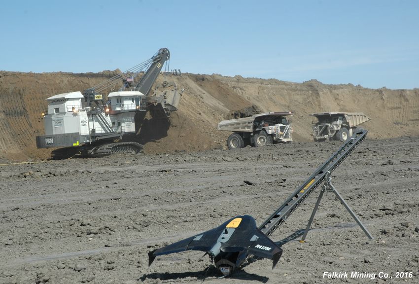
about every hour and a half, imagery and a broad range of other         acquisition in response to disastrous flooding events in the Red
data from across the electromagnetic spectrum is collected across       River Valley. U.S. Customs and Border Protection operate two
the entire globe (USGS, 2015).                                          Reapers in support of the mission to secure the northern U.S.
                                                                        border (fig. 4). These drones call the Grand Forks AFB home and
Drone Capabilities in North Dakota                                      patrol more than an 800-mile stretch of the international border
North Dakota has numerous drone capabilities within both the            between the U.S. and Canada. Each Reaper costs $20 million,
military and civilian sectors, predominantly in the Red River Valley.   and is operated at a cost of about $12,000 an hour, according to
Over the last decade, Grand Forks has continued to grow as the          cost evaluations compiled by the U.S. Office of Inspector General
nation’s leading drone innovation and development center on three       (USOIG, 2014). The Reaper has an altitude ceiling of 50,000 feet
fronts: the opening, in 2015, of the Grand Sky UAS business park at     and can fly for as long as 20 hours at speeds of up to 276 mph,
the Grand Forks Air Force Base (currently home to the Global Hawk       roughly half the speed of a commercial jet. Reapers are also used
and the 348th Reconnaissance Squadron); the Northern Plains UAS         by the U.S. Air Force, the U.S. Navy, NASA, and the CIA.
Test Site, one of seven FAA UAS test sites across the nation tasked
with the integration of drone platforms into U.S. airspace without
detriment to the general and commercial aviation industries;
and the University of North Dakota’s Center of Excellence in UAS
Training, Research, and Education; within the John D. Odegard
School of Aerospace Sciences. Together they provide avenues for
collaboration across disciplines and opportunities to develop new
applications for drones in North Dakota.

Drone industry leaders at Grand Sky will also be spearheading the
development of anti-drone technologies in addition to continuing
to provide excellent testing environments for the beyond visual
line of sight (BVLOS) mission in cooperation with the Northern           Figure 4. An MQ-9 Predator B Drone (Reaper), manufactured by
Plains UAS Test Site (NPUASTS, 2017). Anchored by Northrop               General Atomics Aeronautical Systems. This is one of two Reapers
Grumman, which supports the U.S. Air Force Global Hawk mission,          operated by the U.S. Customs and Border Protection in support of the
the park is expected to grow and develop with companies like             mission to secure the northern U.S. border. These drones have also
General Atomics (manufacturer of the Predator) continuing to             supported flood-fighting efforts in the Red River Valley (USCBP, 2017).
expand flight operations and training capabilities. Drawing from
the academic and extensive simulation resources at the Center for       Opportunities for Implementation
Unmanned Aircraft Systems at UND and the local drone industry,          There are numerous opportunities for implementation of drones
new projects, like the recently awarded NASA-sponsored UAS              in North Dakota’s natural resource regulatory and investigative
Traffic Management Project, will also continue to emerge (UND           landscape. Key among these are enhanced inspection and
Aerospace, 2017).                                                       monitoring of oil and gas activities, geologic hazards such as
                                                                        flooding and landslides, abandoned mine land reclamation,
In the southern Red River Valley, the North Dakota Air National         and North Dakota’s hydrologic systems and infrastructure. The
Guard’s 119th Wing, located in Fargo, provides direct military          following is just a sample of both proven and potential applications.
mission support for the U.S. along with air reconnaissance
capabilities for the state (fig. 3). The 119th Wing is the home         Locating Legacy Abandoned Oil and Gas Wells
of North Dakota’s “Happy Hooligans” where until recently; the           Finding oil and gas wells when information on their whereabouts is
Predator (MQ-1) Unmanned Aerial Vehicle (UAV) was flown. This           sparse or non-existent is an application of using drones equipped
summer the 119th Wing will be flying MQ-9 Predator Bs (also             with geophysical instrumentation to detect the location of a “lost”
known as “Reapers”) as their current aerial services platform           well collar. Detailed surveys of candidate legacy well locations
(NDANG, 2017).                                                          can be completed by equipping a drone with a magnetometer
                                                                        to relocate lost wells so they may be properly abandoned and
Over the past decade, the State of North Dakota and North Dakota        reclaimed. In the State of New York for example, it is estimated
Department of Emergency Services have leveraged the use of              that the locations of more than half of the wells drilled for oil and
U.S. Customs and Border Protection drones for data and imagery          gas since the 1800s are unknown (Adamson, 2016). Fortunately,
                                                                        here in North Dakota, our oil plays started much later, and well
                                                                        locations are not a common problem.

                                                                  Figure 3. The MQ-1 “Predator” UAV has flown in North Dakota as a
                                                                  part of the North Dakota Air National Guard’s 119th Wing also known
                                                                  as the “Happy Hooligans.”

JULY 2017 9 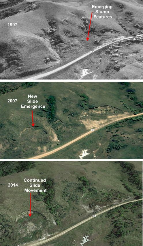
General Electric has recently built a new drone platform called
the Raven, which is equipped with instrumentation to directly
detect methane leaking from wells and pipelines. This innovative
drone successfully completed a test project on oil and gas wells
in Arkansas last summer (Moon, 2016). Drone platforms like
these could be used to conduct high-resolution surveys for
pipeline inspections more efficiently than with vehicular-based or
traditional walking inspections.
Interestingly, NASA’s Jet Propulsion Laboratory (JPL) has also
recently completed the construction of a similar drone with
methane-detecting instrumentation that is far more sensitive
than traditional hand carried instruments (fig. 5). For example,
the hand-held field instrumentation used by the NDGS to detect
the presence of methane in groundwater wells in a 2006-2010
statewide study could detect methane in the parts per million
range. To visualize such a small concentration, one part per million
is about equivalent to 10 bricks in the entire construction of the
empire state building (TED-Ed, 2017). NASA’s new Open Path
Laser Spectrometer (OPLS) has the capability to detect methane
concentrations in the parts per billion range, which could help to
locate leaking pipelines much earlier (NASA, 2016), resulting in
less costly repairs and remediation.
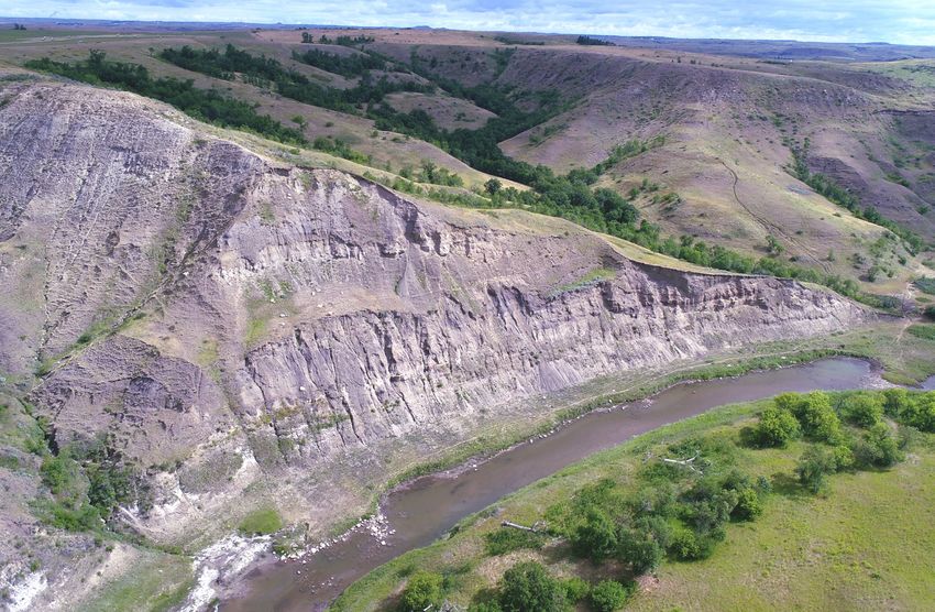
Measuring Landform Change over Time in Support of
Slope-Stability Analyses
Another drone application is the high-frequency repeat aerial
surveying of landslides in western North Dakota (fig. 6). One way
to monitor slope stability at a newly engineered site is through
the completion of repeat localized low-level drone surveying. By
flying the drone over the project location and nearby areas of
concern on a daily, weekly, or monthly basis, depending on the
type and characteristics of the slide area, detailed topographic
surveys can be completed rapidly and compared to previous
surveys for signs of movement within the slope mass. Performing Figure 6. Pseudo-oblique images rendered in Google Earth of
this relatively low-cost style of monitoring can provide companies landslide features along County Road 80 just west of Huff, ND show
and regulatory agencies with an added level of assurance that a the emergence and continued movement of these slides over an
questionable location is structurally and environmentally sound. 18-year time period from 1997 to 2014. Employing a drone to pe-
riodically monitor areas like these along transportation corridors
Mine Surveying and Abandoned Mines Reclamation across the state could provide additional cost savings by detecting
An economically and environmentally valuable way of using changes along engineered slopes prior to large scale failure.
drones in the mining industry is in the facilitation of hyper-
accurate surveying in order to better quantify operational mining
models and volumetrics and to conduct detailed topographic
surveys of pre- and post-mining conditions. North American
Coal Corporation’s Falkirk Mine near Underwood in southeastern
McLean County is leading the nation in drone-based mine
surveying techniques. Falkirk was recently touted (Schmidt, 2016)
as the first surface coal mine in the nation to operate a survey
drone with federal approval (fig. 7).
Drones carrying geoscience-instrumented payloads could provide
several exciting opportunities for geological investigations in
Figure 5. NASA JPL’s OPLS sensor onboard this small drone can de- North Dakota including mining reclamation. Drone-based high-
tect methane in concentrations in the parts per billion (ppb) range resolution surveying, mapping, and monitoring of the subsidence
(about equal to one drop of water in an Olympic size pool) and could of abandoned underground coal mines could enhance the
be an aid to future oil and gas pipeline inspections and surveys. identification and reclamation of these potential public hazards.
10 GEO NEWS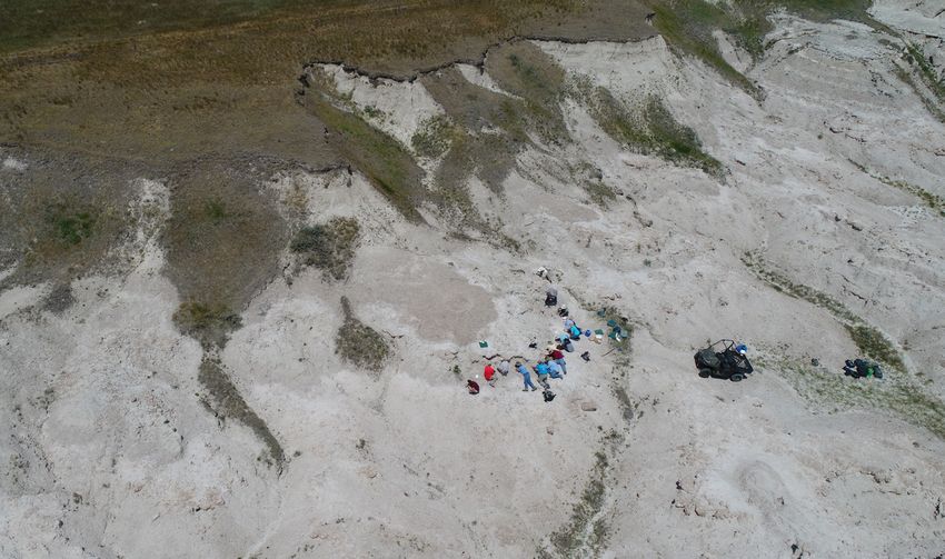
Traditionally, when measuring a stratigraphic
                                                                                           section, the field geologist traverses the outcrop by
                                                                                           walking up the section and measuring the thickness
                                                                                           of particular beds of rock and writing detailed
                                                                                           descriptions of the lithologies along the way. With
                                                                                           a drone, one can conduct a detailed topographic
                                                                                           and imagery analysis of the entire outcrop, not
                                                                                           just one measured path along it, without risking
                                                                                           the safety of the geologist. Employing multiple
                                                                                           cameras or different types of sensors on the
                                                                                           drone, such as thermal cameras, Geiger counters,
                                                                                           gravimeters, or magnetometers, can also increase
                                                                                           the variety of geological data that can be collected.
                                                                                           Detailed data and imagery analysis can reveal new
                                                                                           insights into mineral assemblages and stratigraphic
                                                                                           divisions traditionally obtainable only after weeks
                                                                                           of field investigation and costly laboratory analysis
                                                                                           (fig. 8).

Figure 7. Technicians at the Falkirk Mine in central North Dakota have been using the     Measuring and Monitoring Paleontological Sites
Trimble UX5 drone to optimize mining operations since the fall of 2015.                   Identifying and mapping newly uncovered
                                                                                          paleontological sites is a time-consuming
Using drone-based surveys for mapping mine subsidence features           and laborious process. Utilizing drone mapping and imaging
greatly increases the level of field safety for the geologist. Drones    technologies can offer opportunities for enhanced mapping of key
are effective substitutes for human observers and eliminate the          fossil beds and surveying of accurate specimen distribution across
necessity of “boots on the ground” in areas where there may              a key fossil locality. In addition, cost-effective repeat surveys can
be unseen or unknown hazards. Regulators “across the pond”               be completed to better preserve and manage these sites (fig. 9).
in the United Kingdom experienced just these conditions while
investigating their legacy mining sites (DroneApps, 2017). They
have been implementing drones in their
continuing investigations and reclamation of
abandoned mine lands by coupling drones
with geophysical methods like microgravity
surveying to improve remedial activities
at legacy sites. Microgravity surveying is a
geophysical investigative method whereby
very small variations in the gravitational field
of Earth are measured in order to determine
the location of voids in the subsurface, such as
abandoned mines or dissolution features such
as traditional sinkholes (Reynolds, 1997).

Perhaps one of the greatest advantages
of using drones in support of geoscience
investigation is their ability to complete
highly accurate repeat surveying and imagery
collection missions at nominal costs on any
desired temporal span. The time span (e.g.
hours, days, weeks, months, etc.) can best
be set to capture the characteristics of the
geologic target of interest.                        Figure 8. A drone photo of an outcrop of the Tertiary age Cannonball Formation (deposited
                                                    by the last sea to cover North Dakota) exposed along the Heart River southwest of Mandan.
Measuring Stratigraphic Sections and                This outcrop is difficult to access for detailed examination owing to its proximity to the river,
Inaccessible Outcrops                               steepness of slope, and loosely consolidated nature of these particular sedimentary rocks.
Another excellent geological application of         Employing a drone to survey hard-to-reach outcrops like this can reveal new geologic insights
drones is in the measuring of hard-to-reach or      and provide unprecedented detail of key outcrops and type sections while considerably
inaccessible outcrops of stratigraphic interest.    improving the safety of the geologist.

JULY 2017 11 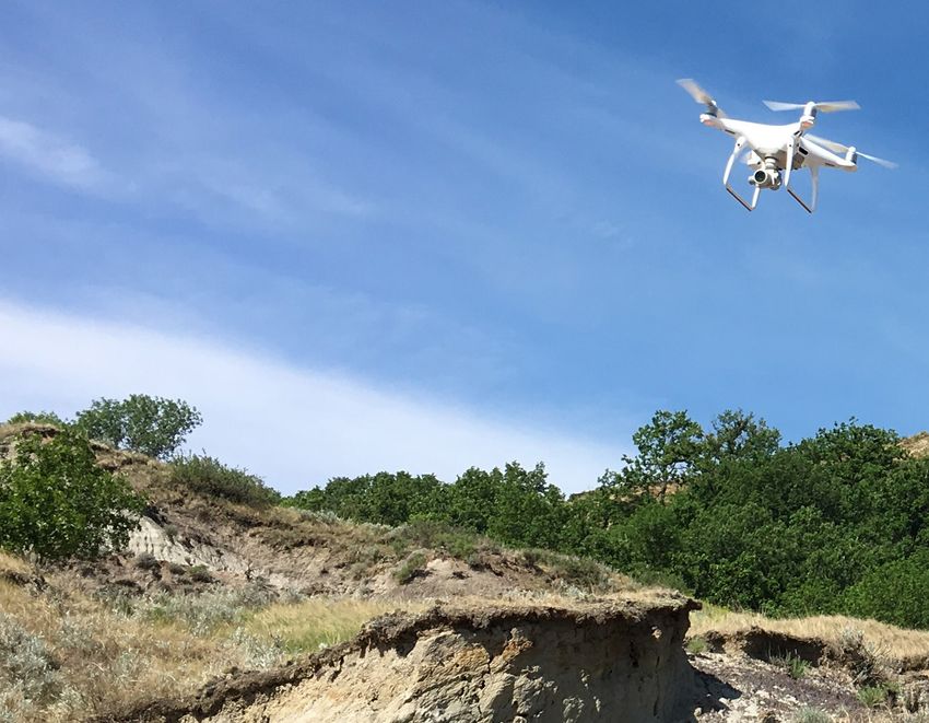
called Autonomous Underwater Vehicles (AUVs)
                                                                                               and have many of the same capabilities as their
                                                                                               airborne counterparts (fig. 10). An AUV is capable
                                                                                               of performing costly surveys of submerged
                                                                                               utility corridors and collecting high-resolution
                                                                                               sonar data that can be used to create three-
                                                                                               dimensional models of submerged landscape
                                                                                               features such as lakeshore landslides (fig. 11) or
                                                                                               detailed profiles of accumulated lake sediment.
                                                                                               Much of the lakeshore around Lake Sakakawea
                                                                                               has been mapped by the NDGS for landslides.
                                                                                               Areas like these, that coincide with locations
                                                                                               of utilities and related energy development
                                                                                               infrastructure, could be relevant candidates for
                                                                                               AUV bathymetric surveys.

                                                                                             Many of the aerial and underwater drones
Figure 9. Drone photo of a NDGS public fossil dig southwest of Dickinson.                    currently in use fall into the Remotely Operated
                                                                                             Vehicle (ROV) category. The fundamental
Surveying the Health of Dam Construction across the State                   difference between ROVs and AUVs is that AUVs operate
It is estimated that many of the dam structures across the United           completely on their own and are not attached or tethered to their
States are in need of repair since a vast majority of them were             deploying platforms or vessels. The National Oceanographic and
built in the early 20th century (Pupovac, 2015). As of 2015, there          Atmospheric Administration (NOAA) currently deploys AUVs for
were 1,223 North Dakota state-regulated dams, 48 classified                 hydrographic surveying in order to identify potential underwater
with a high hazard potential (meaning if the dam failed there               hazards to commercial and recreational navigation and is also
could be significant economic consequences and potential loss               evaluating their use for bathymetric surveying in support of
of life) (NDSWC, 2017). Periodic surveys using unmanned aerial              NOAA’s nautical charting mission (NOAA, 2017). There are several
systems equipped with LiDAR, photogrammetric, or perhaps                    relevant applications for using AUVs in North Dakota, including
even thermally sensitive instrumentation, could provide clues               submerged utilities inspection, both pre- and post-construction,
to aging structures needing repair or replacement. These cost-              and detailed bathymetric studies for higher quality mapping of
effective measures would be beneficial for safety and regulatory            submerged lake-bed topography and potential identification of
programs with insufficient investigation and inspection resources.          submerged historical, archaeological, or potential paleontological
Also, monitoring reservoir volumes and sedimentation rates in               sites (C&C Technologies, 2017).
retention structures via drone mapping can lead to more cost-
effective management and overall performance. Adapting aerial
drone technology for use in the surface aquatic environment, such
as in the surveying of difficult-to-access water bodies like volcanic
lakes has proven to be achievable and surprisingly affordable
(McFarlane et al., 2017).

Autonomous Underwater Vehicles (AUVs)
In addition to aerial drones, there are also unmanned systems
capable of operating in the water. These types of vehicles are

                                                                            Figure 11. Numerous landslides along the lakeshore of Lake Sakakawea
                                                                            have been mapped with traditional aerial photographic techniques to the
                                                                            water line (Murphy, 2010). AUV bathymetric surveys completed along
Figure 10. The Iver3-580 is an AUV that can independently conduct de-       areas like this (outlined with the cross-hatched light blue pattern) could
tailed acoustic and magnetometer surveying along with collecting under-     provide additional detailed information about the continuity and poten-
water imagery that can be used in submerged utilities inspection and in     tial reactivation of submerged landslide features and identify potential
the evaluation of underwater slope stability in lakeshore settings.         problem areas not identifiable by traditional aerial mapping methods.

12    GEO NEWS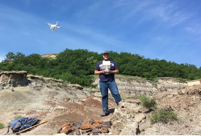
Opportunities for Collaborative Flights
Returning to the sky, one of the most readily identifiable
opportunities for implementing drones in geological investigative
and regulatory inspection work across large areas of the landscape
is the “piggyback” concept of attaching instrument payloads
to aircraft that are regularly flying a primary mission, ideally a
training exercise. For example, partnering with UND Aerospace to
fly tight high-resolution airborne geophysical grids, such as gravity
and aeromagnetics, for each county in North Dakota could provide
unique opportunities to investigate the geophysical properties of            Figure 12. The Perdix autonomous micro-drone, developed
the subsurface geology of North Dakota at unprecedented levels               by MIT’s Lincoln Laboratory, is capable of flying in swarms
of detail. This information could reveal undiscovered economic               and has completed naval surveillance missions in a collective
geologic prospects and provide unique opportunities for drone                and autonomous fashion (Harper, 2016).
pilot training by repetitively holding tight flight lines across a
dense, relatively low-altitude geophysical survey grid.                  Currently, we are using the drone to collect oblique aerial imagery
                                                                         for sites of potential geologic hazard, particularly landslides.
The Future of Drones in the Geosciences                                  Historically, landslides were mapped from aerial imagery and
There are certainly many new and exciting opportunities for the          stereo pairs. In more recent years, the addition of Google Earth
implementation of drones in the geosciences that can increase the        has allowed the user to view oblique imagery as well. However,
detail, accuracy, and efficiency of conducting field investigations,     lack of quality, distorted models, and years of data acquisition
all while providing for increased safety to the field geologist.         gaps do not do oblique angles justice. High quality oblique aerial
The near future holds even more exciting possibilities with the          photography is very important in natural hazard assessment,
potential use of swarming autonomous micro-drones (fig. 12) that         which is why drones will feature so prominently in the future for
are effectively pre-programmed for the mission, launched, and            geological mapping (fig. 14).
then allowed to figure out on their own the most efficient method
of completing the programmed assignment (U.S. DoD, 2017).                There is a multitude of remote sensing needs that many different
Imagine arriving at your field site in the morning, programming          drones can accommodate. At this time, we have found that the
your “birds” for flight, releasing them into the sky on their way to     cost-efficient Phantom 4 Pro serves many of these. The sharp
their pre-programmed area of investigation, and then they return         photography and videography it provides are essential for site and
to the field site on their own later in the day with all of the needed   natural hazard assessments. In the future, we will evaluate drones
information collected and ready for processing and evaluation.           that can handle more rigorous operations such as magnetics,
                                                                         LiDAR, and multispectral sensing, enabling geologists to conduct a
Implementing UAS use at the NDGS                                         variety of Survey missions.
We recently acquired the inexpensive
Phantom 4 Pro Drone and put it to immediate
use in support of the geologic and landslides
mapping mission. The Phantom is flown by a
single geologist and can fly vertical take-off and
landing missions on demand. The drone can
fly missions for over twenty minutes at a time.
Additional battery supplies allow a geologist
to reach several sites in a day. The drone is an
effective and cheap method for photography
compared to an airplane or helicopter. A site
can be photographed in a shorter time frame
with a drone than a helicopter or airplane
which requires more planning and associated
costs.

Our drone is equipped with a 20 megapixel
gimbal camera, resulting in stunning still
photography. Also, the camera records 4K
video (60 frames per second) giving a clear
overview of geologic sites. The pilot operates
the drone using a remote control and is able         Figure 13. Survey geologist Chris Maike, an FAA Part 107 Certified Drone Pilot, flies the
to observe the pictures and drone locations          Phantom 4 Pro drone while collecting imagery along the rugged topography of the Missouri
via a live feed through a tablet screen (fig. 13).   River Valley south of Bismarck.

JULY 2017 13 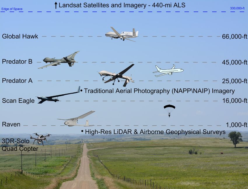
McFarlane, D.A., Lundberg, J., Van Rentergem, G., and Ramirez, C.J.,
2017, An autonomous boat to investigate acidic crater lakes, Eos, 98,
https://doi.org/10.1029/2017EO073409, (retrieved June 5, 2017).
Moon, 2016, GE Made an Oilfield Drone that Sniff Out Gas Leaks, Engad-
get, Enhttps://www.engadget.com/2016/10/09/ge-gas-leak-sniffing-
drone/, (retrieved March 17, 2017).
Murphy, 2010, Areas of Landslides, Sanish SW Quadrangle, 1:24,000 scale
landslide map.
NASA, 2016, Mini NASA Methane Sensor Makes Successful Flight Test,
National Aeronautics and Space Administration, Jet Propulsion
Laboratory-Californian Institute of Technology News, https://www.
jpl.nasa.gov/news/news.php?feature=6192, (retrieved April 21,
2017).
NDANG, 2017, 119th Wing Factsheet, http://www.119wg.ang.af.mil/
About-Us/Fact-Sheets/Display/Article/1132682/119th-wing-fact-
sheet/, (retrieved February 24, 2017).
NDSWC, 2017, Regulatory Program: Dam Safety, North Dakota State Wa-
ter Commission, http://www.swc.state.nd.us/reg_approp/damsafe-
ty/ (retrieved February 17, 2017).
NOAA, 2017, Autonomous Underwater Vehicles, National Ocean-
ographic and Atmospheric Administration, Office of Coast
Survey,https://www.nauticalcharts.noaa.gov/csdl/AUV.html,
(retrieved February 10, 2017).
NPUASTS, 2017, Northern Plains UAS Test Site, http://www.npuasts.com/,
(retrieved June 21, 2017).
Pupovac, J., 2015, Aging and Underfunded: America’s Dam Safety
Problem, in 4 Charts, National Public Radio, Prairie PublicBroad-
casting, http://www.npr.org/2015/10/11/447181629/aging-and-
underfunded-americas-dam-safety-problem-in-4-charts, (retrieved
February 17, 2017).
Reynolds, 1997, An Introduction to Applied and Environmental Geophys-
ics, John Wiley and Sons, Ltd, pp. 105.
Schmidt, D., 2016, Flying High – The Sky’s the limit as North Dakota
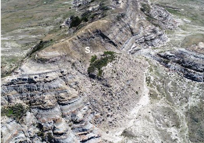
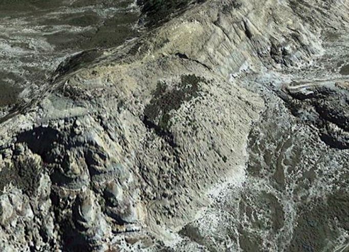
Figure 14. Comparison of pseudo-oblique aerial imagery rendered in Mine Takes and Innovative Approach to Surveying and Monitoring,
Google Earth (above) with recent true oblique imagery (below) collected Coal Age, http://www.coalage.com/features/5252-flying-high.html#.
with the Survey’s new Phantom 4 Pro Drone. Fresh weathering of a scarp WTqt2cuGM-I, (retrieved February 17, 2017).
(S) is visible in the drone imagery of a landslide originating within badlands TED-Ed, 2017, How to Visualize one part per million, http://ed.ted.com/
topography of the Sentinel Butte Formation in western North Dakota. lessons/how-to-visualize-one-part-per-million-kim-preshoff-the-ted-
ed-community, (retrieved February 3, 2017).
UND Aerospace, 2017, UND Aviation – Unmanned Aircraft Systems, www.
uasresearch.com, (retrieved June 21, 2017).
References U.S. DoD, 2017, Department of Defense Announces Successful
Adamson, M., 2016, Locating Abandoned Oil and Gas Wells using Drone- Micro-Drone Demonstration, U.S. Department of Defense Press Re-
Aeromagnetics [abs.]: Geological Society of America Abstracts with lease No. NR-008-17, https://www.defense.gov/News/News-Releas-
Programs, v. 48, no. 7. es/News-Release-View/Article/1044811/department-of-defense-
Anderson, F.J., 2017, Unmanned Aerial Systems in North Dakota – Regula- announces-successful-micro-drone-demonstration, (retrieved March
tory and Investigation Opportunities for the DMR: North Dakota Geo- 24, 2017).
logical Survey, Agency PowerPoint Presentation. USCBP, 2015, Unmanned Aircraft System MQ-9 Predator B, U.S. Customs
C&C Technologies, 2017, Government Services: http://www.cctechnol. and Border Protection, Fact Sheet, https://www.cbp.gov/sites/de-
com/government-services, (retrieved February 10, 2017). fault/files/documents/FS_2015_UAS_FINAL_0.pdf, (retrieved March
DroneApps, 2017, Uncovering the coal industry’s hidden legacy, Case 24, 2017)
Studies, https://droneapps.co/drone-inspection-coal-industry/, (re- USGS, 2015, Landsat-Earth Observation Satellites, United States Geological
trieved March 24, 2017). Survey, Fact Sheet 3081, 4 pp., https://pubs.usgs.gov/fs/2015/3081/
Harper, J., 2016, Secretive Pentagon Office Developing Next-Generation fs20153081.pdf, (retrieved June 27, 2017).
Swarming Drone, National Defense, NDIA’s Business and Technol- USOIG, 2014, U.S. Customs and Border Protection’s Unmanned Aircraft
ogy Magazine, http://www.nationaldefensemagazine.org/blog/Lists/ System Program Audit Report, https://www.oig.dhs.gov/assets/
Posts/Post.aspx?ID=2292, (retrieved April 13, 2017). Mgmt/2015/OIG_15-17_Dec14.pdf, (retrieved March 24, 2017).
14 GEO NEWS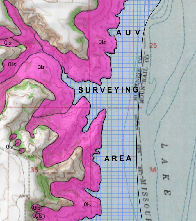
You can also read