"Walk along the Mt. Vettore Fault" - Field Trip Guidebook June 29th, 2019
←
→
Page content transcription
If your browser does not render page correctly, please read the page content below
“Walk along the Mt. Vettore Fault”

         Field Trip Guidebook
             June 29th, 2019

              Emanuele Tondi
              Tiziano Volatili
           Pietro Paolo Pierantoni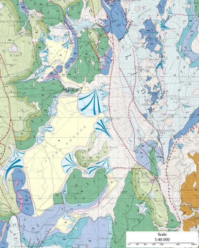
INDEX

1. Geological and geodynamic framework of Central Apennines .......... 2
  1. 1. Central Apennines ..................................................................... 2

2. Field Trip to the epicentral area of 2016 Amatrice, Visso, and Norcia
earthquake........................................................................................... 9
  2.1 Introduction ................................................................................... 9
  2.2 Field Trip ..................................................................................... 14
     Forca di Presta: introduction to the geology of the Monte Vettore area ... 16

     Mt. Vettore Fault: walk along the "Cordone del Vettore" fault scarp ....... 20

     Colli Alti e Bassi: free face observation along a bedrock fault scarp ........ 22

* The present guidebook has been extracted and modified from the international field trip guidebook:

                            https://convegni.unicam.it/TDEq_centralItaly

                                                                                                       1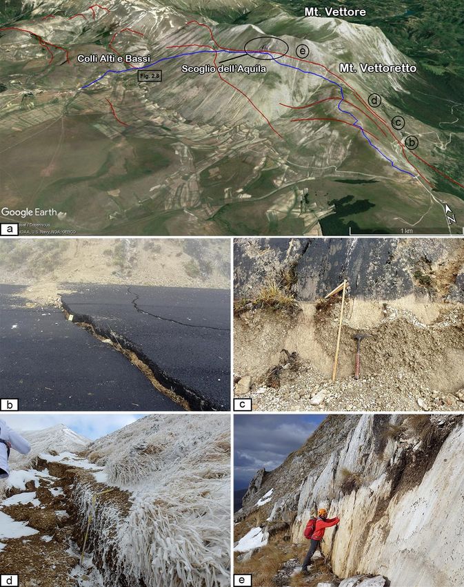
1. Geological and geodynamic framework of Central
Apennines
1. 1. Central Apennines

The Central Apennines (Fig. 1.1) are part of a post-collisional segment of the
Mediterranean Africa-vergent mountain system which is made up of several tectonic
units emplaced since the Oligocene, as a result of convergence and collision between
the continental margins of the Corsica-Sardinia block, European origin, and of the
Adriatic block, African affinity, (Vai and Martini, 2001 and references therein).

Fig. 1.1. Synthetic tectonic map of Italy and surrounding seas; 1) Foreland areas; 2) foredeep
deposits; 3) domains characterized by a compressional tectonic regime; 4) Alpine orogen; 5)
areas affected by extensional tectonics: these areas can be considered as a back-arc basin
system developed in response to the eastward roll-back of the west-directed Apenninic
                                                                                            2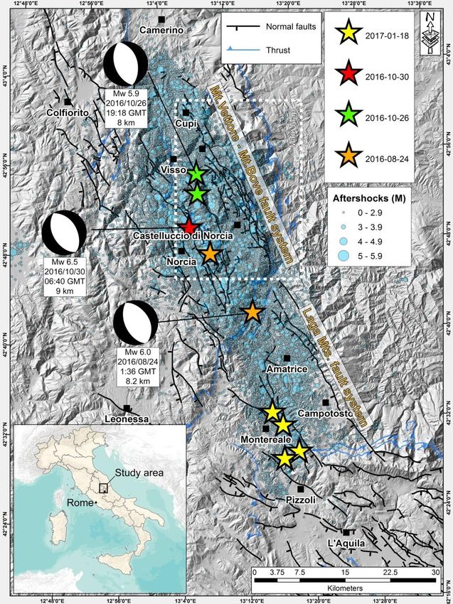
subduction; 6) crystalline basement; 7) oceanic crust in the Provençal Basin (Miocene in age)
and in the Tyrrhenian Sea (Plio-Pleistocene in age) and old Mesozoic oceanic crust in the
Ionian Basin; 8) Apenninic water divide; 9) main thrusts; 10) faults. From Scrocca et al.,
2003.

The Meso-Cenozoic stratigraphic successions exposed in the Central Apennines are
composed by different environments and depositional systems. During the Triassic, a
shallow water carbonate platform and euxinic basins paleo-environments controlled
the depositions of shallow-marine carbonates, dolostones and sulphates about 1.5-2
km thick (Bally et al., 1986). During the lower Jurassic, a rifting stage took place in
the whole Neotethyan region causing a basin-platform system. The paleogeography
related to this period was persistent until early Tertiary times. The shallow-water
platform domain was broken-up and new platform-basin systems developed,
characterized by downthrown sectors dominated by transitional to deep-water
sedimentation, with deposition of limestones, marly limestones, and marls, and
upthrown sectors with shallow-water carbonate platform deposits. The early-middle
Cretaceous regional paleogeography was quite similar to that of the late Jurassic. The
platform-basin systems led to the deposition of thick, shallow- and deep-water
carbonate successions (up to 4-6 km thick, Bally et al., 1986). In the platform
domain, a late Cretaceous-early Miocene hiatus was followed by deposition of early
Miocene paraconformable carbonates, deposited along a carbonate ramp (Civitelli and
Brandano, 2005), while in the deeper domains sedimentation continued throughout
the Paleogene. During Eocene-Oligocene times a critical scenario developed in the
proto-western Mediterranean area, with the existence of the S-SE-directed Alpine
subduction system (approaching the end of its existence) and the young NW-dipping
Apennines subduction system starting its activity (Carminati et al., 2012), which
possibly developed along the retrobelt of the Alpine orogeny (Fig. 1.2). This means
that two subduction systems, with nearly opposite polarity, were present in a
relatively narrow area for a short time.
During the late Miocene, the southern Neotethyan passive margin was involved in the
evolution of the Apennines, that accreted the sedimentary cover of the passive margin
during the “eastward” roll-back of the NW-dipping Apennines subduction system (Fig.

                                                                                           3
1.2; Carminati and Doglioni, 2005). The Apennine slab roll-back induced subsidence
and boudinage of large portions of the Alps that have been scattered and
dismembered into the Apennines-related backarc basin: the Provencal and the
Thyrrenian (Fig. 1.2). Within this geodynamical setting, tectonically-controlled
sedimentary basins developed with the deposition of hemipelagic marls in a foreland
environment in the Central Apennines, followed by deposition of turbidites composed
of siliciclastic sandstones in a foredeep setting ahead the propagating deformative
front (Patacca and Scandone, 1989; Cipollari and Cosentino, 1991; Patacca et al.,
1991; Milli and Moscatelli, 2000; Critelli et al., 2007). North-eastward migration of
thrust fronts (Cipollari et al., 1995) developed different tectonic units that pushed
carbonate ridges, oriented NW-SE, onto turbiditic basins (Ricci Lucchi, 1986;
Boccaletti et al., 1990; Cipollari et al., 1995; Patacca and Scandone, 2001; Cosentino
et al., 2010).

                                                                                    4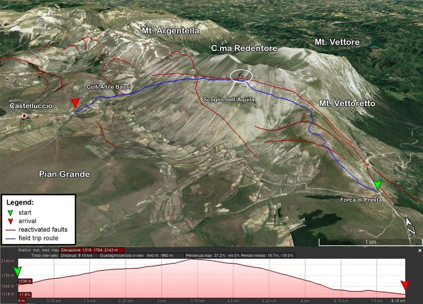
Fig. 1.2. The early “east”-directed Alpine subduction was followed by the Apennines “west”-
directed subduction, which developed along the retrobelt of the pre-existing Alps. The slab is
steeper underneath the Apennines, possibly due to the “westward” drift of the lithosphere
relative to the mantle (From Carminati and Doglioni, 2005).

                                                                                            5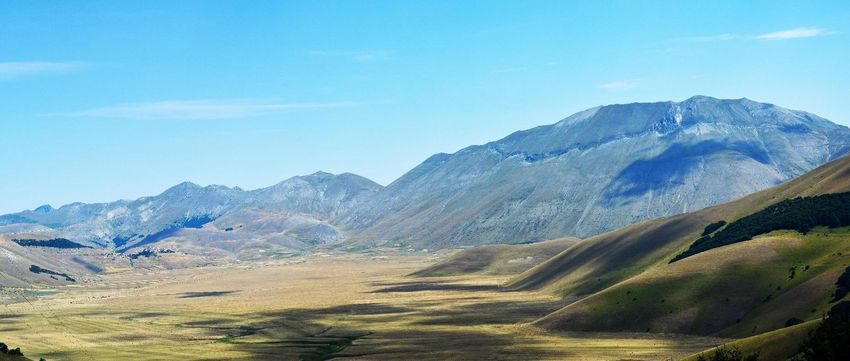
Fig. 1.3. Cross section from Corsica (SW), through Tyrrhenian Sea and across the Apennines
(NE). The Apennine prism (light green) developed along the retrobelt of the alpine orogen (the
blue double-wedge in the center of the section). The alpine orogen was boudinaged and
stretched by the backarc rift. Above the cross section are reported the vertical movements.
From Carminati et al., 2010.

Following the kinematics of W-dipping subduction and applying the westward drift of
the lithosphere, the Apennines should float above a new asthenospheric mantle, which
replaced the subducted lithosphere, causing the uplift of the accretionary wedge of
the Apennines chain (Fig. 1.3; Carminati et al., 2010). Nowadays the Apennines are
characterized by a frontal active accretionary wedge, below the Adriatic Sea, whereas
the inland elevated ridge is instead in uplift and extension, controlled by tensional
regime oriented about NE-SW (Fig. 1.1; Calamita et al., 1994; Lavecchia et al., 1994;
Doglioni and Flores, 1995; Cello et al., 1997).This is generally inferred from the age of
the different intramontane sedimentary basins filled by alluvial and lacustrine
sediments (e.g., Fucino, Sulmona and L’Aquila basins), initiated by the extensional
tectonic activity affecting the Central Apennine area since the late Messinian and still
active. New stratigraphic data on the depositional sequences filling the L’Aquila and
Rieti Basin shows common inception of these extensional structures in the upper
Pliocene (Cosentino et al., 2017). These intramontane basins are mainly bordered by
NW-SE oriented and SW-dipping normal to transtensional faults cutting throughout
                                                                                            6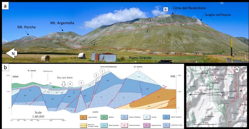
the crust, generating most of the seismicity in the region (Fig.1.4; Cavinato et al.,
2002; Barchi et al., 2000; Tondi and Cello, 2003).
Tondi and Cello (2003), integrating the geological information on exposed active faults
in the area together with the historical earthquakes, reconstructed the seismic cycle of
the entire active fault system for the last millennium (Tab. 1). These authors
estimated the displacement rate of the whole system in the last 700 ka to be 1.6
cm/year and the average recurrence time for M>6.5 events to be about 350 years,
with Faure Walker et al. (2010) suggesting ~3mm/yr. In Fig. 1.4 are reported the
main active faults and the three seismic sequences occurred in the area from 1997 to
2016.

Tab.1. Historical earthquakes associated to the active faults in Fig. 1.4 (Rovida et al., Eds.,
2015)

                                                                                             7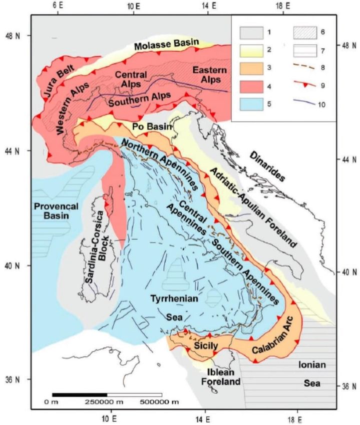
Fig. 1.4. a) Location map of Figure 1b with the three main arcs of the Apennine chain. b)
Seismotectonic sketch of the field trip area with the main Neogene thrusts (black lines) and
Quaternary/active normal fault systems (red lines). The Mt. Cavallo (MCT), Sibillini Mts (MST)
and Gran Sasso (GS) thrust ramps are oblique to the main (N)NW–(S)SE trend of the normal
fault systems (modified from Di Domenica and Pizzi, 2017).
                                                                                            8
2. Field Trip to the epicentral area of 2016 Amatrice, Visso,
and Norcia earthquake

2.1 Introduction

Along the axial zone of the Apennine, the main active tectonic structures in the area
are the Mt. Vettore - Mt. Bove fault systems (VBFS, hereinafter; Calamita et al.,
1992; Calamita and Pizzi, 1992, 1994; Cello et al., 1997; Pizzi et al., 2002, Pizzi and
Galadini 2009), the Laga Mountains (Galadini and Galli, 2000, 2003; Galli et al.,
2008), the Norcia (Galli et al., 2005) and the Montereale (Civico et al., 2016) fault
systems.).
The recent activity of the VBFS has been indicated by geomorphological and
paleoseismological studies (Calamita et al., 1992; Brozzetti and Lavecchia, 1994;
Calamita and Pizzi, 1994; Blumetti, 1995; Coltorti and Farabollini, 1995; Cello et al.,
1998; Galadini and Galli, 2003; Galli et al., 2005). The VBFS is the easternmost fault
system in the Central Apennines; it is characterized by WSW dipping normal faults
about 5-7km long with en-echelon pattern, and in some cases linked by transfer
faults. The VBFS is extended from Mt. Bove, to the north, till Mt. Vettore to the south
intersecting the Olevano–Antrodoco–Sibillini Mts. thrust (OAST). In particular, the
amount of displacement related to the Quaternary activity of the 30 km long VBFS
abruptly decreases near its intersection with the OAST-ramp (Pizzi and Scisciani,
2000). Here, the SE termination of the fault system is made up of two segments. The
tip of the eastern segment, although covered by Quaternary slope deposits, is not
present as far as 1.5 km SE from the intersection with the OAST trace, where the
outcropping strata of the Messinian sandstones (OAST footwall unit) are not displaced
by the fault. The strike of the western segment clearly deflects parallel to the trace of
the OAST and the displacement progressively dies out 3 km to the south (Pizzi and
Galadini, 2009).
Since August 2016, a series of moderate to large earthquakes hit the central
Apennines    generating   important   damage   in   numerous    towns   (e.g.   Amatrice,
Castelluccio di Norcia, Visso) and causing almost 300 casualties and more than 20,000

                                                                                       9
homeless (Civico et al. & Open EMERGEO_WG 2018; Villani et al. & Open
EMERGEO_WG 2018). The seismic sequence (Chiaraluce et al., 2017 and references
therein) started with an Mw 6.0 mainshock on 24 August at 1km west of Accumoli.
After two months (26 October), a new mainshock of Mw 5.9 occurred at 3 km NW of
Castel Sant’Angelo sul Nera, followed by the largest shock of the sequence, a Mw 6.5
on 30 October 2016 at 5 km NE of Norcia. These have been the strongest seismic
event in Italy since the Irpinia earthquake (Ms 6.9) in 1980 (Westaway and Jackson,
1987; Bernard and Zollo, 1989). Additional events occurred in the southern sector of
the sequence on 18 January 2017, with a maximum Mw of 5.5. Aftershocks are
confined to the upper crust (10-12 km maximum depth) and follow a roughly NW-SE
trend for about80 km between the towns of Camerino to the north and Pizzoli to the
south (Chiaraluce et al., 2017).
The affected area has been repeatedly struck by 5.3 > Mw < 6.9 earthquakes in the
last 400 years, with the largest local earthquake occurring in 1639 at Amatrice with
an Io 9–10 MCS and an estimated M 6.2 (Rovida et al., 2016). In recent times,
moderate-sized earthquakes struck Norcia in 1979 with a Mw 5.8 (Deschamps et al.,
1984), Colfiorito in 1997 with a Mw 6.0(Amato et al., 1998; Tondi and Cello, 2003;
Tondi et al., 2009), and L’Aquila in 2009 with a Mw 6.1 (Chiaraluce et al., 2011;
Valoroso et al., 2013).
10Fig 2.1. The 2016-2017 central Italy seismic sequence as recorded by the INGV Italian
National Seismic Network (data from ISIDe - Italian Seismological Instrumental and
Parametric Data-Base - http://iside.rm.ingv.it) for the time period of 24 August 2016 through
23 January 2017. Time Domain Moment Tensor focal mechanisms are from the INGV web page
(http://cnt.rm.ingv.it). Faults are compiled from Centamore et al. (1992) and Pierantoni et al.
(2013) and Galli et al. (2008). The white dashed box encloses the area of the Main Map.
After the most important seismic events, important surface ruptures were observed
along the VBFS by different groups and institutions mainly conglomerated in the Open
EMERGEO Group.
11After the 24 August 2016, Mw 6.0 normal-faulting Amatrice earthquake (Fig. 2.1):
~N155°-trending surface ruptures, mostly SW dip-slip kinematics (average
displacement of 0.15 m), were recorded for several kilometers along the southern
portion of the VBFS (EMERGEO Working Group, 2016; Lavecchia et al., 2016). These
coseismic features were interpreted as the response of primary surface faulting by
Livio et al., 2016, Aringoli et al., 2016 and Pucci et al., 2017, while unclear and
discontinuous coseismic features were recorded along the Laga Mts. fault system by
most of the research groups working in the area. The earthquake of 26 October 2016,
Mw 5.9, near Castel Sant’Angelo sul Nera, caused sparse and discontinuous (few
hundred of meters long) ground ruptures along the northern portion of the VBFS
(average vertical displacement of 0.15 m). Unfortunately, the field survey on the
coseismic effects of this latter event was not fully achieved due to the 30 October Mw
6.5 mainshock close to Norcia (Fig. 2.1). This seismic event produced coseismic
effects on an area of nearly 450 km2 mainly consisting of primary surface ruptures
(Fig. 2.2), accompanied with other secondary effects like landslides. An almost
continuous pattern of surface ruptures was observed for an overall length of 20-25 km
along the whole VBFS, generally reactivating the 24 August and the 26 October 2016
ground ruptures (Fig.2.2). Surface rupture displacement exhibits predominantly
normal dip-slip kinematics, with an average 0.5 m vertical offset. Notably, the
~N155° striking alignment of ground ruptures typically follows the trace of mapped
faults (Pierantoni et al., 2013 and references therein), while in some locations the
coseismic ruptures occurred along fault splays that were not previously recognized.
Remote surveys verified and integrated with field data evidenced an almost
continuous alignment of ground ruptures along closely-spaced, parallel or subparallel,
overlapping or step-like synthetic and antithetic fault splays pertaining to the VBFS
(20-25 km long). Field observations after the 30 October 2016 earthquake reveal that
its coseismic surface rupture pattern can be considered one of the most complex
recorded in Italy and in the Mediterranean in the past 40 years in terms of number of
involved fault splays, in a normal faulting earthquake context (Civico et al. & Open
EMERGEO_WG 2018; Villani et al. & Open EMERGEO_WG 2018).
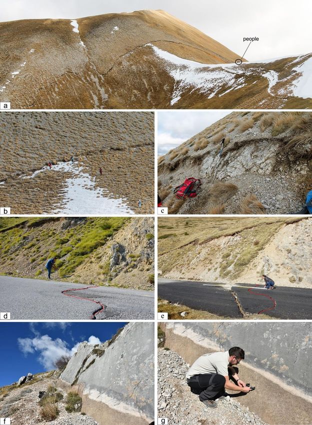
12Fig. 2.2. Examples of coseismic ruptures along the Mt. Vettore - Mt.Bove fault system as seen
in the field. (a) panoramic view of the Mt. Porche coseismic rupture; (b) close up of the Mt.
Porche rupture; (c) detail of decametric throw; (d, e) evidences of coseismic rupture of the
same location on different time (d, 24/06/2016; e, 19/11/2016) (f, g) metric coseismic vertical
dislocation along a fault plane located in Colli Alti e Bassi.
132.2 Field Trip
Fig. 2.3. Oblique view from satellite of the Southern part of the Sibillini Mountains where the
reactivated faults (red lines) and the field trip route (blue line) are displayed. At the bottom of
the figure the trail elevation profile is shown.
From the satellite image in Fig. 2.3, it is possible to observe the landscape of the
Southern area of the Sibillini Mountains, where surface expressions of the VBFS are
visible from satellite. Mt. Vettore is the highest peak of the Sibillini Mountains (2476
m a.s.l.), followed by Cima del Redentore (2449 m a.s.l.). The villages in this area
have been severely damaged by the October 30 mainshock, with an Is from 9 to 10.5
(MCS local intensity; Galli et al., 2017).
The first stop is located at Forca di Presta locality, an introduction of the geological
14framework of this area will be given, taking advantage of an exceptional panoramic
view where it is possible to see the main fault surface expressions affecting the
western slope of Mt. Vettore.
Then the hike starting from Forca di presta will continue along the “Cordone del
Vettore” fault scarp (Fig. 2.6) also known as “la Strada delle fate”. This name has
taken from a myth.
“The legend says that beautiful sparkling fairies, linked by a spell to the Sibyl, an evil
sorceress, descended into the valley during the night to dance with the local
shepherds. Each fairy represented an element of nature, fire, snow, water, flowers
and so on. The fairies were beautiful from the waist up, but they had goat feet. They
could dance all night but before dawn they had to return to the underworld. One
night, amazed by the music they did not notice the rising of the sun and, when the
first rays of the sun hit the tops of the mountains, they gave themselves to a mad
race towards the entrance of their kingdom (the cave of the Sibyl). With their goat
feet, in their mad run, they forever marked the face of Monte Vettore, creating what is
still called "la Strada delle Fate”.
After leaving the main fault scarp the group head downslope to “Colli Alti e Bassi”
locality (CAB), about 1km east from Castelluccio di Norcia. In this location, we can
appreciate a fault scarp related to a synthetic splay (Fig. 2.8) and finally the field trip
ends in the Pian Grande.
15Forca di Presta: introduction to the geology of the Monte Vettore area
The Castelluccio basin is an intramontane depression, located in the central
Apennines, and filled by Pleistocene to Holocene fluvial-lacustrine deposits; bedrock
units are instead represented by limestone and pelagic marls of Jurassic to Miocene
age. The main geomorphological modeling of the landscape started during the Late
Pliocene, when arid or sub-tropical humid climatic conditions, favorable to planation
processes, created a “paleo”-landscape with gentle relief. The subsequent tectonic
phase, active since the Early-Middle Pleistocene until now, is characterized by dip- and
oblique-slip faults and strong uplift. These processes interrupted and dissected the
previous landscape, forming the tectonic depression, same as the other nearby basins
(Colfiorito, Norcia, Cascia, Leonessa, ecc.) within the central Apennines (Aringoli et
al., 2012, and references therein).
The western slope of Mt. Vettore is marked by at least two major normal faults: the
lower fault runs at the base of the Vettore escarpment and bounds the Castelluccio
basin. The upper fault runs very close to the top of Mt. Redentore, marked by a
clearly visible fault scarplet (“Cordone del Vettore”, Fig. 2.6a) crosscutting the Upper
Triassic-Lower Liassic carbonates Corniola and Calcare Massiccio (Pierantoni et al.
2013). In the area of Palazzo Borghese-Mt. Porche, a E-W trending Jurassic fault
causes the sharp juxtaposition of the basinal sequence of Mt. Porche (north) with the
condensed sequence of Palazzo Borghese (south). In the latter structure, the
condensed sequence’s beds are also unconformable on the upper fault scarp.
The seismicity that affected Central Italy since August 24 was attributed to the
activation of the entire VBFS, between the northern slope of the Tronto River valley
and the area of Ussita. It includes segments identified along the western slopes of Mt.
Vettore, Mt. Argentella, Palazzo Borghese, Mt. Porche and Mt. Bove (Calamita and
Pizzi, 1992, Coltorti and Farabollini, 1995, Cello et al., 1997, Pizzi et al., 2002;
Galadini and Galli, 2003; Pizzi and Galadini, 2009). Considering the evidence of local
activity and the lack of historical earthquakes associated with it, the fault was
previously considered "silent", assuming that it was presumably tied to a seismic gap
(Galadini and Galli, 2000).
16A recent geological map (Pierantoni et al., 2013) provides a detailed trace of these
faults (Fig. 2.4). The Mt. Vettore normal fault crosses and displaces the Sibillini thrust
fault for some hundred meters. According to some authors, normal faulting may have
locally reutilized some steeper shallow planes of the thrust zone (Calamita et al.,
1994; Di Domenica et al., 2012 and bibliography therein). Recent activity on the
normal faults was described by Scarsella (1947) and confirmed by several Authors in
more recent times, who studied the geomorphic evolution of the Castelluccio Basin
(e.g. Blumetti, 1991; Calamita et al., 1994; Coltorti and Farabollini, 1995), pointing
out the occurrence of fault escarpments and scarplets. According to these Authors,
the Castelluccio Basin is produced by extensional tectonics with slight left lateral
component.
17Fig. 2.4. Geological map of the western slope of Mt. Vettore (from: Pierantoni et al., 2013).
The yellow star shows your location.
18Fig. 2.5. Outline of the fault scarps related to the main normal faults of the Mt. Vettore-Mt.
Bove system. a) Panoramic view of the Sibillini Mountains indicating the surface expression of
major faults activated during the last earthquake sequence of 2016. b) Cross-section
orthogonal to the panoramic view indicating the continuation of the faults in depth, which
crosscut the Umbro-Marchigiana succession. The most evident expression of the coseismal
rupture is given along (1) the Cordone del Vettore where the maximum offset (nearly 2m) is
present at Scoglio dell’Aquila, (2) fault splay also reactivated, (3) the main fault with a
cumulative offset of about 2000m, and (4) a Jurassic fault also reactivated.
19Mt. Vettore Fault: walk along the "Cordone del Vettore" fault scarp
This stop consists on a walk along the fault segment located on the southern slope of
Mt. Vettoretto in order to arrive just below the top of Cima Redentore, where we can
appreciate the metric fault scarp commonly named “Cordone del Vettore”.
A set of very clear ground ruptures are visible on the southern slope of Mt. Vettoretto.
These ruptures mainly strike between NNW‐SSE, with a slight left‐lateral horizontal
component. They generally affect colluvium and soil, often very close to the bedrock
fault plane, but sometimes at a distance of several meters. These ruptures can be
followed almost without interruption from the SP34 (province road) to the end of Mt.
Vettoretto slope. The province road shows an offset about 10-20 cm (Fig.2.6b). Going
a few meters to uphill, even more evidence of coseismic ruptures are found and the
offset increases to 50-60 cm (Fig. 2.6c). Continuing up to the end of Mt. Vettoretto
the observable offset gradually increases up to 60-80 cm (Fig. 2.6d). Archiving the
“Cordone del Vettore” fault scarp, the offset largely increases showing a “free face”
with about 2 m vertical throw close to Scoglio dell’Aquila (Fig. 2.6e).
20Fig. 2.6. a) Satellite view of the location, blue line: hike route, red lines: reactivated faults
extracted by Pierantoni et al. 2013; b, c, d, e) coseismic structures encountered along the
walk.
21Colli Alti e Bassi: free face observation along a bedrock fault scarp
This stop is located along the NS-striking "Colli Alti e Bassi" normal fault (CAB), a
synthetic structure of the Mt. Vettore master fault (Fig. 2.7a).
The CAB lowers westward the Early Cretaceous pelagic "Maiolica" Fm (hanging wall
block), with respect to the Early Jurassic shelf carbonates of the Calcare Massiccio Fm
(footwall) (Fig. 2.7b, section B-B1). The CAB dips on average, to W - SW, with sharp
changes of attitude, from to 255-42 to 215-70, on an extent of a few hundred meters.
The observed stratigraphic omission allows to assess a long-term displacement of 380
m (throw of ~355 m).
Fig 2.7. Structural-geological sketch of the Mt Vettore - Piano Grande area with stop locations
(red full circles); CAB: Colli Alti e Bassi site, CG: Capanna Ghezzi sit. Blue and green colors
22refer to outcrop of Jurassic and Cretaceous Fms (respectively) of the Umbria-Marche
carbonatic succession; brown colors refer to outcrop of Miocene ramp muds and turbidite
foredeep successions. b) Geological sections across the western slope of Mt. Vettore showing
the west-dipping normal fault system driving the Quaternary evolution of the study area.
On the CAB site, we can observe an exposure of a continuous fault scarp, some
hundred meters-long, showing a spectacular free face, 50 to 100 cm-high (Fig. 2.8).
The latter can be entirely attributed to the surface faulting event of the MW 6.6, 30
October 2016 Earthquake. In fact, the detailed field mapping performed by our
research unit, in the 24 August-29 October interval, led us to exclude any reactivation
of tye CAB during the Mw 6.0, Amatrice, and 26 October Mw 5.9, Visso, earthquakes.
Both striations on the fault plane and correlation of piercing points, recognizable on
the two faulted blocks, record normal kinematic, locally with a minor left-lateral
component (Fig. 2.8).
Fig. 2.8: Spectacular outcrop of the Colli Alti e Bassi normal fault showing the free face due to
coseismic slip of the October 30 Mw 6.5 earthquake.
From a structural point of view, this valley corresponds to a narrow graben delimited
by the CAB to the east and by the East-dipping antithetical fault of Mt. Arbuzzago, to
the west (Fig. 2.7a).
23REFERENCES
Aringoli D., Farabollini P., Giacopetti M., Materazzi M., Paggi S., Pambianchi G., Pierantoni P. P., Pistolesi
E., Pitts A. and Tondi E. (2016). The August 24th 2016 Accumoli earthquake: surface faulting and
Deep-Seated Gravitational Slope Deformation (DSGSD) in the Monte Vettore area. Ann. Geophys.,
59(5), http://dx.doi.org/10.4401/ag-7199.
Aringoli D., Cavitolo P., Farabollini P., Galindo-Zaldivar J., Gentili B., Giano S., Lòpez-Garrido A. C.,
Materazzi M., Nibbi L., Pedrera A., Pambianchi G., Ruano P., Ruiz-Constàn A., Sanz de Galdean C.,
Savelli D., Tondi E. and Troiani F. (2014). Morphotectonic characterization of the quaternary
intermontane basins of the Umbria-Marche Apennines (Italy). Rend. Lincei Scienze Fisiche e Naturali.
Barchi M., Galadini F., Lavecchia G., Messina P., Michetti A. M., Peruzza L., Pizzi A., Tondi E. and Vittori E.
(2000). Sintesi delle conoscenze sulle faglie attive in Italia Centrale: parametrizzazione ai fini della
caratterizzazione della pericolosità sismica. NR-Gruppo Nazionale per la Difesa dai Terremoti, Roma.
Bernard P. and Zollo A. (1989). The Irpinia (Italy) 1980 earthquake: Detailed analysis of a complex
normal faulting. J. Geophys. Res., 94(B2), 1631–1647, doi:10.1029/JB094iB02p01631.
Calamita F., Pizzi A. and Roscioni M. (1992). I fasci di faglie recenti ed attive di M. Vettore – M. Bove e di
M. Castello – M. Cardosa (appennino Umbro-Marchigiano). Studi Geologici Camerti, 1992/1, 81-95.
Calamita F. and Pizzi A. (1994). Recent and active extensional tectonics in the southern Umbro-Marchean
Apennines (central Italy). Mem. Soc, Geol. It., 48, 541-548.
Calamita F., Coltorti M., Farabollini P., and Pizzi A. (1994). Le faglie normali quaternarie nella Dorsale
appenninica umbro-marchigiana. Proposta di un modello di tettonica d’inversione. Studi Geol.
Camerti Vol. spec, 211–225.
Calamita F., Coltorti M., Pieruccini P., and Pizzi A. (1999). Plio-Quaternary structural and
geomorphological evolution from the Umbro-Marchean Apennines to the Umbrian Pre-Apennines and
the Adriatic coast, Boll. Soc. Geol. Ital., 118(1), 125–139.
Calamita F., Coltorti M., and Pieruccini P. (2002). Quaternary normal faults, intramontane basins and
seismicity in the Umbria-Marche-Abruzzi Apennine Ridge (Italy): contribution of neotectonic analysis
to seismic hazard assessment, Boll. Soc. Geol. It., 1, 923–929.
Carminati E. and Doglioni C. (2005). Mediterranean Geodynamics: Encyclopedia of Geology. Elsevier,
135-146.
Carminati E., Lustrino M., Cuffaro M. and Doglioni C. (2010). Tectonics, magmatism and geodynamics of
Italy: What we know and what we imagine. In: (Eds.) Marco Beltrando, Angelo Pecceril-lo, Massimo
Mattei, Sandro Conticelli, and Carlo Doglioni, The Geology of Italy, Journal of the Virtual Explorer,
Electronic Edition, ISSN 1441-8142, Vol. 36, paper 8, 2010.
Carminati E., Lustrino M. and Doglioni C. (2012). Geodynamic evolution of the central and western
mediterranean: Tectonics vs. igneous petrology constraints. Tectonophysics, 579, 173–192,
doi:10.1016/j.tecto.2012.01.026.
Cavinato G. P., Cosentino D., De Rita D., Funiciello R. and Parotto M. (1994). Tectonic sedimentary
24evolution of intrapenninic basins and correlation with the volcanotectonic activity in Central Italy.
Mem. Descr. Carta. Geol. d'It. 49, 63-76.
Cavinato G. P. and De Celles P. G. (1999). Extensional basins in the tectonically bimodal central
Apennines fold-thrust belt, Italy: Response to corner flow above a subducting slab in retrograde
motion, Geology, 27, 955–958.
Chiaraluce L., Di Stefano R., Michele E. M., Casarotti E., Cattaneo M., De Gori P., Chiarabba C.,
Monachesi G., Lombardi A., Valoroso L., Latorre D. and Marzorati S. (2017). The 2016 Central Italy
Seismic Sequence: A First Look at the Mainshocks, Aftershocks, and Source Models, Seismological
Research Letters, 88, 3, doi: 10.1785/0220160221.
Chiaraluce L., Barchi M., Collettini Mirabella F. and Pucci S. (2005). Connecting seismically active normal
faults with Quaternary geological structures in a complex extensional environment: The Colfiorito
1997 case history (northern Apennines, Italy). Tectonics, 24, TC1002, doi: 10.1029/2004TC001627.
Cello G., Mazzoli S., Tondi E. and Turco E. (1997). Active tectonics in the central Apennines and possible
implications for seismic hazard analysis in peninsular Italy. Tectonophysics 272, 43-68.
Cello G. (1997). Fractal analysis of a Quaternary fault array in the Central Apennines, Italy. Journal of
Structural Geology 19 (7), 945–953.
Cello G. and Tondi E. (Editors) (2000). The resolution of geological analysis and models for earthquake
faulting studies. Journal of Geodynamics, Special issue 29, (3/5): 151-564.
Civico R., S. Pucci, F. Villani, L. Pizzimenti, P. M. De Martini, R. Nappi & the Open EMERGEO Working
Group (2018) Surface ruptures following the 30 October 2016 Mw 6.5 Norcia earthquake, central
Italy, Journal of Maps, 14:2, 151-160, DOI: 10.1080/17445647.2018.1441756.
Critelli S., La Pera E., Galluzzo F., Milli S., Moscatelli M., Perrotta S. and Santantonio M. (2007).
Interpreting siliciclastic-carbonate detrital modes in foreland basin system: An example from Upper
Miocene arenites of the central Apennines, Italy. Geol. Soc. Am. Spec. Pap., 420, 107–133.
Doglioni C. (1991). A proposal of kinematic modelling for W-dipping subductions – Possible applications
to the Thyrrenian – Apennines system. Terra Nova, 3, 4, 423-434.
Doglioni C. and Flores G. (1995). An introduction to the Italian Geology. Ed. Il Salice, Potenza, 1-95.
Doglioni C., Mongelli F. and Pialli G. P. (1998). Boudinage of the Alpine Belt in the Apenninic Back-arc.
Mem. Soc. Geol. It., 52, 457-468.
D’Agostino N. (2014). Complete seismic release of tectonic strain and earthquake recurrence in the
Apennines (Italy). Geophys. Res. Lett., 41, 1155–1162, doi:10.1002/2014GL059230.
Di Domenica, A., Turtù A., Satolli S. and Calamita F. (2012). Relationships between thrusts and normal
faults in curved belts: New insight in the inversion tectonics of the Central‐Northern Apennines
(Italy).Journal of Structural Geology, 42, 104‐117.
Di Domenica, A. and Pizzi, A.: Defining a mid-Holocene earthquake through speleoseismological and
independent data: implications for the outer Central Apennines (Italy) seismotectonic framework,
Solid Earth, 8, 161-176, https://doi.org/10.5194/se-8-161-2017, 2017.
Faure Walker, J. P., Roberts, G. P., Sammonds, P., Cowie, P. A., 2010 Comparison of earthquakes strains
25over 102 and 104 year timescales: insights into variability in the seismic cycle in the central
Apennines, Italy. Journal of Geophysical Research, VOL.115,B10418,doi:10.1029/2009JB006462,
2010.
Galadini F. and Galli P. (2003). Paleoseismology of silent faults in the Central Apennines (Italy): the
Mt.Vettore and Laga Mts. faults. Annals of Geophysics.
Gasparini C., lannaccone G. and Scarpa R. (1985). Fault-plane solutions and seismicity of the Italian
peninsula. Tectonophysics, 117: 59-78.
Galli P., Galadini F. and Calzoni F. (2005). Surface faulting in Norcia (central Italy): a “paleoseismological
perspective”, Tectonophysics, 403, 117-130
Galli P., Galadini F. and Pantosti D. (2008). Twenty years of paleoseismology in Italy. Earth-Science
Reviews, 88, 89–117. https://doi.org/10.1016/j.earscirev.2008.01.001.
Lavecchia G., Castaldo R., Nardis R., De Novellis V., Ferrarini F., Pepe S. and Brozzetti F. (2016). Ground
deformation and source geometry of the 24 August 2016 Amatrice earthquake (Central Italy)
investigated through analytical and numerical modeling of DInSAR measurements and structural‐
geological data. Geophysical Research Letters 43, no. 24.
Livio F., Michetti A. M., Vittori E., Gregory L., Wedmore L., Piccardi L., Tondi E., Roberts G., Blumetti A.
M., Bonadeo L. and Brunamonte F. (2016). Surface faulting during the August 24, 2016, Central Italy
earthquake (Mw 6.0): preliminary results. Annals of Geophysics 59, doi:10.4401/ag-7197 (2016).
Locati M., Camassi R. and Stucchi M. (eds) (2011). DBMI11, the 2011 version of the Italian Macroseismic
Database. Milano, Bologna, http://emidius.mi.ingv.it/DBMI11. Accessed 18 Mar 2015.
Mildon, Z.K., Roberts, G.P., Faure Walker, J.P., Wedmore, L.N.J. and McCaffrey, K.J.W. (2016) Active
normal faulting during the 1997 seismic sequence in Colfiorito, Umbria: did slip propagate to the
surface? Journal of Structural Geology, ISSN 0191-8141.
Milli S. and Moscatelli S. (2000). Facies analysis and physical stratigraphy of the Messinian turbiditic
complex in the Valle del Salto and Val di Varri (central Apennines). G. Geol., 62, 57–77.
Patacca E. and Scandone P. (2001). Late thrust propagation and sedimentary response in the thrust belt-
foredeep system of the Southern Apennines. In Anatomy of an Orogen: The Apennines and Adjacent
Mediterranean Basin, edited by G. B. Vai and I. P. Martini, pp. 401–440, Kuwler Academic Publishers,
Dordrecht, Netherlands.
Pierantoni P., Deiana G. and Galdenzi S. (2013). Stratigraphic and structural features of the Sibillini
Mountains (Umbria-Marche Apennines, Italy), Ital.44, doi:10.1002/ 2016GL071859.
Pierantoni P.P., Deiana G. and Galdenzi S., (2013) Geological map of the Sibillini Mountains (Umbria-
Marche Appennines, Italy). Italian Journal Geoscience.
Ricci Lucchi F. (1986). The Oligocene to recent foreland basins of the Northern Apennines. IAS Spec.
Publ., 8, 105–139.
Rovida A., Locati M., Camassi R., Lolli B. and Gasperini P. (eds) (2016). CPTI15, the 2015 version of the
Parametric Catalogue of Italian Earthquakes. Istituto Nazionale di Geofisica e Vulcanologia.
doi:http://doi.org/10.6092/INGV.IT-CPTI15
26Scarsella F. (1947). Sulla geomorfologia dei piani di Castelluccio e sul carsismo nei Monti Sibillini.
Bollettino Ufficio Geologico d’Italia.
Scrocca D., Doglioni C. and Innocenti F. (2003). Constraints for an interpretation of the italian
geodynamics: a review. Mem. Descr. Carta Geol. It., 15-46.
Shimazaki K. and Nakata T. (1980). Time-predictable recurrence model for large earthquakes.
Geophysical Research Letters 7, 279–282.
Stucchi M. (1985). The earthquakes in central Italy, January- February 1703. Some questions, some
preliminary answers. In: D. Postpischl (Editor), Atlas of Isoseismal Maps of Italian Earthquakes.
Quaderni de La Ricerca Scientifica, b, C.N.R., Roma, 114: 56-57.
Tondi E., Cello G. and Mazzoli S. (1997). Strutture sismogenetiche in Appennino Centrale: potenziale
sismico, analisi frattale e processi di crescita. Il Quaternario, 10/2, 409-414.
Tondi E. (2000). Geological analysis and seismic hazard in the Central Apennines. Special Issue: “The
resolution of geological analysis and models for earthquake faulting studies”, G. Cello and E. Tondi
(Eds.), Journal of Geodynamics, 29: 3-5, 517-534.
Tondi E. and Cello G. (2003). Spatiotemporal Evolution of the Central Apennines Fault System (Italy).
Journal of Geodynamics, 36, 113-128.
Tondi E., Chiaraluce L. and Roberts G. (Eds.) (2009). "Ten years after the Umbria-Marche earthquake".
Tectonophysics, Vol. 476, Issue 1-2.
Villani F., Civico R., Pucci S., Pizzimenti L., Nappi R., De Martini P. M. and the Open EMERGEO Working
Group (2018) A database of the coseismic effects following the 30 October 2016 Norcia earthquake in
Central Italy. Sci. Data 5:180049 doi: 10.1038/sdata.2018.49.
Vittori E., Deiana G., Esposito E., Ferreli L., Marchegiani L., Mastrolorenzo G., Michetti A. M. Porfido S.,
Serva L., Simonelli A. L. and Tondi E. (2000). Ground effects and surface faulting in the September-
October 1997 Umbria-Marche (Central Italy) seismic sequence. Special Issue: “The resolution of
geological analysis and models for earthquake faulting studies”, G. Cello and E. Tondi (Eds.), Journal
of Geodynamics, 29: 3-5, 535-564.
Wells D. L. and Coppersmith K. J. (1994). New empirical relationships among magnitude, rupture length,
rupture width, rupture area, and surface displacement. Bull. Seismol. Soc. Am., 84: 974-1002.
Westaway R. (1992). Seismic moment summation for historical earthquakes in Italy: tectonic
implications. J. Geophys. Res., 97: 15,437-15,464.
Wilkinson M., McCaffrey K. J. W., Jones R. R., Gerald P. R., Holdsworth R. E., Gregory L. C., Walters R. J.,
Wedmore L., Goodall H. and Iezzi F. (2017). Near-field fault slip of the 2016 Vettore Mw 6.6
earthquake (Central Italy) measured using low-cost GNSS. Scientific Reports, doi:10.1038/s41598-
017-04917-w
www.protezionecivile.gov.it/httpdocs/cms/attach_extra/GuidelinesForSeismicMicrozonation.pdf
27You can also read