Earth gravity from space or how attractive is our planet?
←
→
Page content transcription
If your browser does not render page correctly, please read the page content below
Features how attractive is our planet?

              Earth gravity from space or
              how attractive is our planet?
                                   llReiner Rummel - rummel@bv.tum.de - DOI: 10.1051/epn/2013103
                       llAstronomical and Physical Geodesy - Technische Universität München - 80 290 München - Germany

24 EPN 44/1        Article available at http://www.europhysicsnews.org or http://dx.doi.org/10.1051/epn/2013103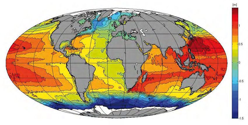
how attractive is our planet? features
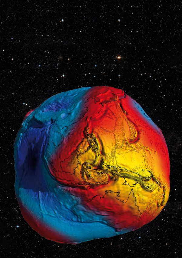
In March 2011 the European Space Agency (ESA) released an impressive new
picture of the figure of the earth. It was based on the first science data from
the satellite GOCE. It shows the geoid with its undulations highly exaggerated,
which makes the Earth look almost like a potato, but very attractive. The picture
received great attention from the media and even made it to the front page of
many leading international newspapers.
G
OCE (acronym for Gravity and steady-state variations of atmospheric pressure. Some contributions b Fig. 1:
Ocean Circulation Explorer) was launched and their size are listed in Table 1. The GOCE geoid
"potato". The geoid
in March 2009. It is still in orbit. The end of The traditional measurement techniques are absolute gravim- undulations are
the mission is projected for the second half etry, employing rather sophisticated free-fall apparatus [1], highly exaggerated.
of 2013, when the spacecraft will have used up most of and relative gravimetry with spring gravimeters. Temporal Their maximum
values, expressed
the Xenon of its ion propulsion system, which is needed variations are measured most accurately by superconduct-
relative to a best
to keep it in an extremely low orbit. Its primary goal is ing gravimeters, stationary and under laboratory conditions. fitting global
the global determination of the geoid and of gravity with They are also relative gravimeters.Their relative sensitivity is as ellipsoid, are -100
an accuracy of one part per million (1 ppm). To achieve high as about 10-12.This approach employs a superconducting meters South of India
and +80 meters
these objectives the principle of gravitational gradiometry sphere which is kept levitated by a magnetic field of super- around New Guinea
is applied, the first time ever in a spacecraft. The gradi- conducting, persistent current coils [2]. However, even more (courtesy: ESA)
ometer instrument consists of three pairs of ultra-precise than fifty years of terrestrial measurement activity worldwide
accelerometers, and the satellite is essentially a labora- resulted only in a rather incomplete and incoherent situation.
tory built around the gradiometer. In order to enhance Only in some highly developed countries dense and accurate
the gravitational signal the orbit altitude is chosen very gravity networks exist. In a much larger part of our world
low, only 255 km. Despite the high accuracy of the gra- gravimetric measurements are either missing or they are
diometer instrument, data analysis can still be based on sparse, inhomogeneous and inaccurate.
Newton’s universal law of gravitation.
Gravity is the combined effect of ‘true’ gravitation and b Fig. 2:
the centrifugal acceleration due to earth rotation. In first The GOCE
gravitational
approximation, for a spherical earth it is a constant, the gradiometer
well-known 9.8 m/s2. The deviations from this value are consists of three
small. The largest, of the order of 1/300, is due to the perpendicular
one-axis
combined effect of centrifugal acceleration and of the gradiometers. Each
Earth’s oblateness which is essentially a result of Earth of them comprises
rotation. Newton was the first to use gravity measure- a rigid bar with two
accelerometers
ments as a confirmation of his theory about equilibrium
at its ends. The
figures and the earth’s flattening. For this purpose he con- accelerometers are
sidered ‘seconds pendulums’ employed for astronomical the gravity signal
measurements, and analysed the adjustments applied to sensors. In each of
them a test mass (4
their length at stations at various latitudes. cm × 4 cm × 1 cm)
is kept levitated
Density variations by an electrostatic
feedback system.
Gravity differences due to topography and density varia- The applied current
tions in the earth’s interior are even smaller; they are less is proportional to
than 10-4. They are caused by phenomena ranging from the gravitational
acceleration signal.
large-scale density variations due to tectonic processes and
mantle convection, to small-scale effects such as cavities in Upper panel: principle
the underground or density jumps in soil or rock material. of the gradiometer
with its six cubic test
For this latter reason, terrestrial gravimetry belongs to the
masses (in red).
standard methods of exploration geophysics. Temporal
variations of gravity are less than 1 ppm. The largest con- Lower panel:
tribution is due to the tidal effect of sun, moon and planets the actual GOCE
gradiometer
on the oceans and the deformable earth. Smaller contribu- instrument
tions are caused, e.g., by changing groundwater levels and (courtesy: ESA).
EPN 44/1 25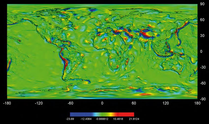
Features how attractive is our planet?

                                                                       Satellites
                                                                       With satellites the earth’s gravitational field can be
        Box 1                                                          measured globally, homogeneously, fast and much
                                                                       more conveniently. The tracking of any earth-orbiting
        The complete gravitational tensor consists of the nine         satellite from observatories on ground may be regard-
        second derivatives Vij = ∂2V/∂xi∂xj of the gravitational       ed as measurement of the free fall of a test mass, the
        potential at the location of the satellite. Due to its sym-    satellite itself, in the gravitational field of the earth. The
        metry only six elements remain. GOCE measures four             orbit trajectory is a Keplerian ellipse; it is precessing in
        of them with high precision, namely Vxx, Vyy, Vzz and Vxz,     space due to the earths flattening, and modulated by
        while Vxy and Vyz are measured much less accurately.           the gravitational signal caused by field variations origi-
        Geometrically, the tensor elements represent the local         nating from the earth, and – to a much lesser extent
        curvature structure of the field, i.e., the curvature of the   – from the sun, moon and planets. The gravitational
        equipotential surfaces and plumb lines. Equivalently,          signal is like a successive series of tiny accelerations
        the accelerations may be interpreted as measurement            and decelerations along the orbit. Already in 1958, with
        of the tidal field generated by the attraction of the Earth    data from Sputnik-1 and Sputnik-2, the Earth’s flat-
        inside the GOCE satellite, cf. [4]. n                          tening could be determined from orbit analysis much

“
                                                                       more accurately than from the preceding 150 years
                                                                       of classical triangulations all around the world. With
                                                                       the advent of the Global Positioning System (GPS)
                                                                       a further break-through happened. Now the orbit of
                                                                       any satellite in a low orbit can be followed from the
In order to recover the small variations of the earth’s                constellation of GPS-satellites in much higher orbit

                                                                 ”
                                                                       uninterruptedly, in three dimensions and with cm-
field, the relative precision has to be 1 ppm                          precision. However, while this approach proved rather
                                                                       successful, being global, uniform and fast, an intrinsic
                                                                       problem remained. It is the limitation of spatial reso-
                                                                       lution due to the large distance of satellites from the
                                                                       Earth. The strength of the field is quickly decreasing
                                                                       with increasing distance from the earth as expressed
                                                                       by Newton’s “inverse squared distance law”.

                                                                       . Fig. 3: GOCE sensor system with the gradiometer instrument in its center,
                                                                       a geodetic GPS-receiver, three star trackers, two ion thrusters at its rear end,
                                                                       magnetic torquers and cold gas thrusters for calibration (courtesy: ESA)

                                                                       b Fig. 4: Global map of geoid heights (in meters) relative to an ellipsoidal
                                                                       figure in hydrostatic equilibrium

26 EPN 44/1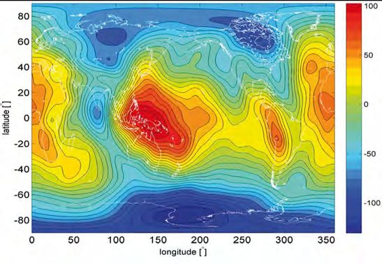
how attractive is our planet? features
Earth gravity and its contributions
Size of effect relative to g [in m/s ]
2
The various contibutions
10 0
Earth as a homogeneous sphere
10 -3
Oblateness and centrifugal acceleration
10 -4
Mountains, valleys, ocean ridges, subduction zones
10 -5
Density variations in lithosphere and upper mantle
10 -6
Sediments, salt domes, ores
10-7 Temporal variations due to solid earth and ocean tides
10-8 Loading effects, atmospheric pressure, groundwater variations b Table 1:
Earth gravity and
10-9 Pole tide, sea level
its contributions
Gravitational gradiometry is a rotation about the out-of-orbit-plane y-axis in inertial
For this reason GOCE is applying the principle of gravita- space. Consequently, the gravitational signal is superim-
tional gradiometry. Gravitational gradiometry is designed posed by centrifugal and angular accelerations. They have
to counteract the signal attenuation at orbit altitude. Instead to be reconstructed and eliminated.While the gravitational
of measuring the “free fall” of a single satellite, gravitational and centrifugal part of the 3×3 matrix formed by the nine
gradiometry is the measurement of the relative motion
between several test masses. In the case of GOCE six test
masses are used. The gradiometer consists of three or-
thogonal single-axis gradiometers, each 50 cm long, with Box 2
their common midpoint at the satellite’s centre of mass. The
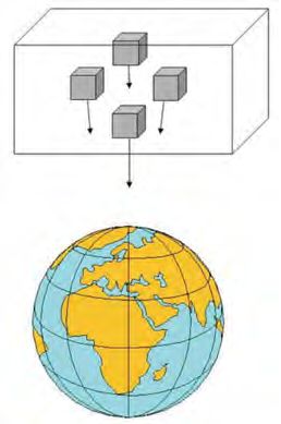
x-axis is parallel to the satellite body of GOCE, roughly in We see a "satellite" with
flight direction, the z-axis is pointing towards the Earth four freely floating test
and the y-axis is perpendicular to the former two, approxi- masses in its interior,
mately orthogonal to the plane of the orbit. Each single- in orbit around the
axis gradiometer has two very precise accelerometers at earth. If one of these
its end points. These contain a 4 cm × 4 cm × 1 cm cubic test masses would be
test mass, made of Rhodium-Platinum. Their weight is 320 placed exactly at the
gram. Each test mass is kept levitated inside its housing centre of mass of the
without touching its walls, suspended by an electrostatic satellite it would re-
feed-back system [3]. If one of these accelerometers would main there. Seen rela-
be placed exactly at the satellite’s centre of mass, it would tive from the satellite,
sense zero-g: The gravitational attraction of the Earth on it feels “zero-g”. Seen
the accelerometer’s test mass would be identical to that on from the outside, the
the satellite. At 25 cm distance from the satellite’s centre the gravitational force of the earth on the satellite is identi-
accelerometers are operating in a “micro-g”-environment. cal in magnitude and direction to that on the test mass.
They sense the tiny gravitational acceleration difference There is no acceleration difference. If the test masses are
of the Earth’s field between the location of the test mass placed slightly “higher” or “lower” or in front or behind
and that of the satellite’s centre of mass, just 25 cm above, the satellite’s centre of mass, as shown in the figure, they
below, in front, behind, to the left or to the right of it. The are attracted by the earth slightly more or less or in a dif-
signal size is less than 10-6 of g. In order to recover the small ferent direction compared to the satellite, as indicated by
variations of the earth’s field, caused by mountains and val- the arrows in the figure. So the test masses are in a “micro-
leys, ocean ridges, subduction zones or mantle convection, g”-environment. There is a tiny difference between earth
the relative precision has to be 1 ppm. See also Box 2. This gravitation on the satellite and on each of the four test
implies that the required sensitivity of the accelerometers cubes. At a distance of one meter from the satellite centre
is of the order of 10-12 m/s2. The gravitational gradients are this difference is of the order of one millionth of g.
then the differences of the measured accelerations in x, y In the case of the GOCE gradiometer, the test masses are
and z direction along each of the three gradiometer arms. kept at a fixed position using an electrostatic feedback
The gradiometer instrument is shown in Figure 2. system. The gradients are derived from the measured
Since the gradiometer instrument is rigidly mounted in the acceleration differences. n
spacecraft and the satellite is Earth-pointing it performs
one full rotation with each orbit revolution. Essentially this
EPN 44/1 27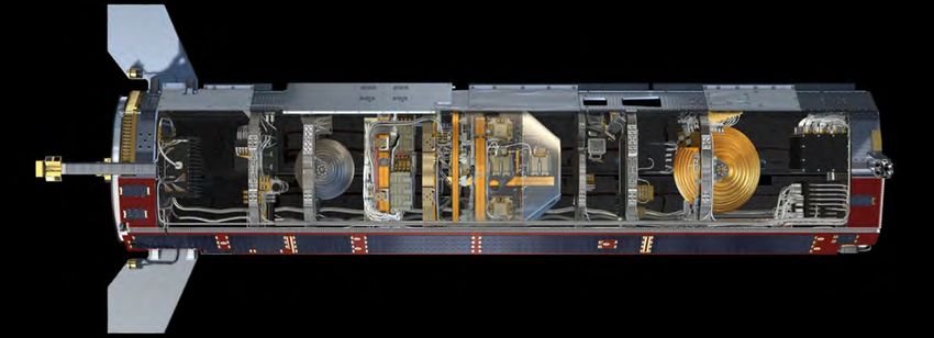
Features how attractive is our planet?

                           acceleration differences is symmetric, the angular accelera-    tailored to the needs of a gravitational experiment of this
                           tions part is skew-symmetric. It can therefore be identi-       high standard. Since November 2009 GOCE is delivering
                           fied. The angular accelerations are then combined with the      science data [6], see also [7].
                           observations of a set of three highly sensitive star trackers   Figure 1 shows the global geoid as derived from the first six
                           in order to reconstruct the angular rates [5]. In parallel      months of data. The bumps and dips shown there represent
                           to the gradiometric method, the gravity field is deduced        the deviations of the geoid from a best fitting ellipsoid; they
                           (with much less spatial details) from the GOCE-orbits in a      range from -100 m south of India to +80 m around New
                           classical manner, as mentioned above. The orbits are recon-     Guinea and they are caused by large density contrasts deep
                           structed purely geometrically from the ranging of GOCE          in the Earth’s mantle. The geoid is one of the level surfaces
                           relative to the GPS constellation, i.e., without employing      of the Earth’s gravity field. It is the equipotential surface
                           orbit mechanics. Regular comparisons with laser distance        at mean sea level. Probably more revealing than figure 1
                           measurements from several ground stations confirm their         is a comparison of the geoid to an ellipsoidal figure in
                           centimetre accuracy.                                            hydrostatic equilibrium, see Figure 4. It nicely emphasizes
                                                                                           the imbalance between the major zones of upwelling hot
                           Atmospheric drag compensation                                   mantle material, the so-called ring of fire, and those with
                           A further novelty of GOCE is its extremely low orbit alti-      colder material descending from the surface into the man-
                           tude of only 255 km. Such low orbit requires continuous         tle. If one removes the long wavelength structure of this
                           compensation of atmospheric drag. The drag effect on            map, say scales longer than 1000 km, the high correlation
                           the spacecraft is measured by the complete set of accel-        of the remaining geoid looks almost like an introduction
                           erometers as common-mode signal and counteracted by             into geodynamics. This is done in Figure 5. It emphasises
                           a set of two proportional ion-thrusters. The orbit is sun-      all tectonic features of the lithosphere and upper mantle,
                           synchronous with an inclination of the orbit plane of 96.7      such as subduction zones, ocean ridges, transform faults
                           degrees relative to the equator plane. In 61 days GOCE          and zones of postglacial uplift.
                           covers the Earth with a dense net of ground tracks. After       This immediately suggests employing the GOCE geoid
                           each of these orbit cycles the gradiometer is re-calibrated.    and gravity maps together with seismic tomography
                           This is done by randomly shaking the satellite with a set of    for a joint inversion, with the goal of improving global
                           cold-gas thrusters. Time varying gravitational effects com-     and regional Earth models. Several groups are currently
                           ing from the satellite itself are minimized. For this reason    working in this direction. First tests show that GOCE
                           the solar panels are rigidly mounted to the satellite body;     is producing much more consistent and accurate grav-
                           the satellite structure is stiffened using carbon sandwich      ity and geoid maps of South America, Africa, Himalaya,
                           structures and the gradiometer instrument is operating          South-East Asia and, very importantly, Antarctica [8]. It
                           under almost perfect thermal stability. The complete sensor     may also shed light on the open question of a suspected
                           system is shown in Figure 3. In summary, the gradiom-           large meteorite impact in Wilkes Land, probably hidden
                           eter is operating in a laboratory environment, perfectly        under Antarctica’s thick ice shield.

               c Fig. 5:
         Global map of
        the short-scale
structure of the geoid
 (spherical harmonics
     up to degree and
 order 20 subtracted).
 The geoid anomalies
       exhibit a strong
      correlation with
           geodynamic
     processes such as
    subduction zones,
          ocean ridges,
      transform faults
   and areas of glacial
 isostatic adjustment

28 EPN 44/1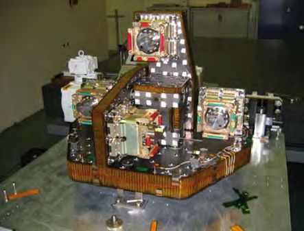
how attractive is our planet? features

Oceanography                                                     Europe and Australia have revealed off-sets of close to one                m Fig. 6: Mean

While in solid-earth physics the geoid serves as a measure       metre. A globally consistent height reference is needed for                dynamic ocean
                                                                                                                                            topography (MDT)
of mass imbalance, its role in oceanography is that of the       sea level studies, geo-information systems and the con-                    deduced from the
hypothetical ocean surface at rest. Without tides, winds         version of GPS-heights to physically meaningful heights                    difference of the
and the effect of atmospheric pressure differences the           above the geoid. GPS-heights alone are simply heights                      mean sea surface and
                                                                                                                                            the GOCE geoid. The
ocean surface would coincide with the geoid. The devia-          above a conventionally adopted reference ellipsoid.                        mean sea surface is
tion of the actual ocean surface from the geoid is therefore     All sensor systems of GOCE are functioning well. The                       derived from twenty
a measure of the strength of ocean circulation. Several very     expectation is that after re-processing and analysis of                    years of satellite
                                                                                                                                            radar altimetry.
accurate models of the actual mean sea surface exist. They       the full data set from November 2009 to summer 2012                        Typical variations of
are derived from a 20-year long sequence of satellite radar      all mission objectives will be met. Currently plans are                    MDT are of the order
altimetry missions. The difference of the two surfaces, the      discussed to use the last year of the mission (from au-                    of 30 centimeters,
                                                                                                                                            MDT of the major
altimetric mean sea surface and the GOCE geoid, gives            tumn 2012 to autumn 2013), to descend the satellite to                     ocean currents such
the mean dynamic ocean topography, representing the              an even lower orbit, ultimately by 20 km. This will further                as Gulf stream,
deviation of the actual sea surface from its hypothetical        enhance the sensitivity and lead to a further improved                     Agulhas, Kuroshio or
                                                                                                                                            Antarctic Circumpolar
state-of-rest. The height variations are only of the order       spatial resolution and accuracy of the GOCE geoid and                      Current reaches
of 20 to 30 cm, with maximum values up to 1 to 2 metres          gravity field world map. n                                                 one to two meters
in the major ocean circulation systems such as the Gulf
Stream, the Kuroshio Stream or the Antarctic Circumpolar
Current, as shown in Figure 6. Ocean topography is main-         References
tained by the balance of the pressure differences induced
by the dynamic topography and the Coriolis force on the          [1] J.E. Faller and I. Marson, Metrologia 25, 49 (1988).
water masses moving relative to the rotating earth. From         [2] J.M. Goodkind, Rev. Sci. Instrum. 70, 4131 (1999).
the slopes of the mean dynamic ocean topography follows          [3] P. Touboul, Space Science Review 108, 393 (2003).
directly the strength of the ocean flow [9]. It is now for the
                                                                 [4] H.C. Ohanian, R. Ruffini, Gravitation and Spacetime, 2nd edition,
first time, that the variations of the mean dynamic ocean             Norton, (1994).
topography are available, globally consistent, accurately        [5] R. Rummel, W. Yi, C. Stummer, Journal of Geodesy 85, 777 (2011).
and with such high spatial detail. They are derived from
                                                                 [6] R. Floberghagen, M. Fehringer, D. Lamarre, D. Muzi, B. From-
space without the aid of any oceanic in-situ data or models.          mknecht, C. Steiger, J. Piñeiro and A. da Costa, Journal of
It is important new input for improved numerical models               Geodesy 85, 749 (2011).
of the ocean and for improved estimates of heat and mass         [7] Q. Schiermeier, Nature 467, 648 (2010).
transport in the oceans.                                         [8] F. Ferraccioli, C.A. Finn, T.A. Jordan, R.E. Belt, L.M. Anderson and
The GOCE geoid model is also needed for a unification                  D. Damaske, Nature 479, 388 (2011).
of the national and regional height systems around the           [9] R.J. Bingham, P. Knudsen, O. Andersen and R. Pail, Geophys. Res.
world. First trials with height data from North America,              Lett. 38, L01606 (2011).

                                                                                                                                                     EPN 44/1 29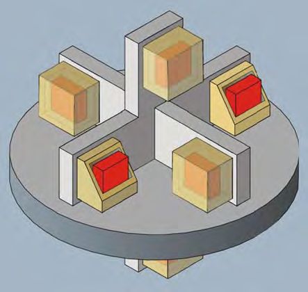
You can also read