Earthquakes as Expressions of Tectonic Activity - Indian Academy of ...
←
→
Page content transcription
If your browser does not render page correctly, please read the page content below
GENERAL ARTICLE

     Earthquakes as Expressions of Tectonic Activity
                            Sources, Types and Examples

                                      Kusala Rajendran

Earthquakes occur as the natural outcome of the processes
that govern a dynamic planet, one that supports plate mo-
tions. The internal structure of the Earth that can sustain the
convective flow of the mantle and the presence of a strong,
fractured outer shell, the lithosphere that can glide over the
underlying asthenosphere are important components of the
plate tectonic framework, and therefore, the global distribu-
                                                                           Kusala Rajendran is a
tion of earthquakes. With an introduction to the ideas of plate
                                                                       Professor of Earth Sciences at
tectonics and earthquake terminology, this article introduces             the Indian Institute of
the significance of the India-Eurasia plate boundary and its             Science, Bangalore. Her
seismic productivity. The most active continent-continent col-         research interests are mostly
                                                                       in understanding the source
lision boundary on the Earth defined by the Himalaya and
                                                                       mechanisms of earthquakes
the Andaman-Sumatra subduction zone are part of this plate              along the plate boundaries.
boundary. Parts of the Indian continental interior regions are
also noted for some destructive earthquakes. This article pro-
vides a brief overview of the background processes, terminol-
ogy, and some highlights on Indian earthquakes studies, and
points to academic opportunities in the area of earthquake
studies.

Earthquakes as a Consequence of Plate Tectonics

Imagine a planet without any active volcanoes, earthquakes, large
oceans and tall and linear mountain chains, running water and soil
cover, all of which are observed on the Earth. It would be barren
and lifeless. As we know today, all planets in the solar system      Keywords
had a common origin, but Earth has an evolutionary history that      Earthquake, plate tectonics, litho-
                                                                     sphere, crust, faults, trench, epi-
is different from that of its siblings. Most importantly, none of
                                                                     center, hypocenter, seismology.
the other planets or their moons developed an outer shell of op-

RESONANCE | March 2018                                                                                337
GENERAL ARTICLE

                              timum thickness, to generate a fragmented architecture. A hard
                              and fragmented outer shell, floating on the partially molten un-
                              derlying layer is the defining character of a planet where plate
                              tectonics can operate. As we know today, Earth is one such,
                              where plate tectonics has been operating for several millions of
                              years, and the ∼100 km thick lithosphere, divided as major and
                              minor plates, glides over the partially molten asthenosphere be-
                              low. Such horizontal and vertical motions of the plates are known
                              as plate tectonics, which is responsible for earthquakes and their
                              global distribution. Thus in order to understand earthquakes, we
                              must first understand the framework of tectonics. Much of the
                              evidence that supports the theory of plate tectonics was put to-
                              gether during the mid-1960s by T J Wilson and validated later by
                              the studies of several pioneering researchers such as D P McKen-
                              zie [1]. Here we recapitulate some essential details to understand
                              how plate tectonics processes are connected to the generation of
                              earthquakes.
                              The basic idea of the plate tectonic model is that the outer shell of
                              the Earth is divided into several plates, both oceanic and con-
                              tinental, which are constantly moving. Movement of tectonic
                              plates ranges from a few millimeters to a few tens of centimeters,
                              as observed from the rate of sea floor spreading and measured
                              by Global Positioning Systems (GPS). Ocean plates are younger
                              (generally younger than 200 million years), denser and thinner,
                              whereas the continental plates are older (mostly > 2 billion years),
                              thicker, and of lower density. The thickness of the oceanic crust
                              varies from 5–8 km, and that of the continental crust varies from
                              35–50 km, with an exceptional thickness of 60–70 km beneath
    Movement of tectonic      the Himalaya, the collided mountain chain. It is to be noted that
 plates ranges from a few     the crust is a part of the lithosphere; it also includes part of the
millimeters to a few tens     mantle. The chemical composition also differs; the oceanic crust
         of centimeters, as
observed from the rate of     is composed mostly of mafic rocks such as basalt and gabbro, and
  sea floor spreading and     the continental crust is made up mostly of less dense felsic rocks
      measured by Global      such as granite.
     Positioning Systems.
                              The fundamental processes that drive plate tectonics originate
                              from the transfer of heat from the Earth’s interior that drives man-

338                                                                        RESONANCE | March 2018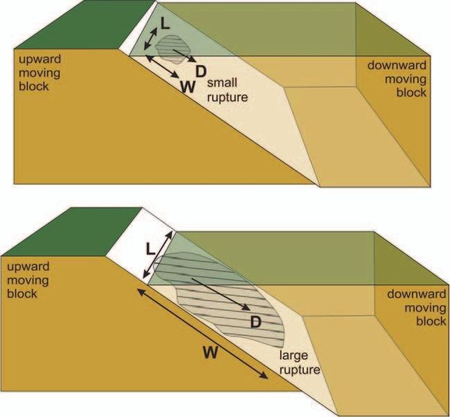
GENERAL ARTICLE

                                                                        Figure 1. The lithosphere
                                                                        of average thickness of ∼100
                                                                        defines the plates that glides
                                                                        laterally over the partially
                                                                        molten asesthenosphere.

tle convection and provides for the forces responsible for the lat-
eral movement of the lithosphere (Figure 1). The convection
and upward movement of hot molten material ultimately result in
venting of lava (basaltic material) along the mid-oceanic ridges.
The cooling and solidification of the high-density basaltic rocks
drives the plate laterally until they eventually collide with another
plate, either with an oceanic plate or with a continental plate.
Where an oceanic plate meets a continental plate, the former be-
ing denser and thinner, would plummet down to the deeper man-
tle, forming a subduction zone also known as a ‘trench’ (e.g.,
Java-Sumatra trench). Great earthquakes sourced on the trench
would create displacement of the ocean floor, some leading to
tsunamis. The collision of two oceanic plates would also lead to
the formation of a trench and volcanic islands, known as ‘island
arcs’ (e.g., Japanese islands). Where a continental plate collides         One of the largest
with another continental plate, one of them would still dive down,         transform faults on the
                                                                           Earth – the San Andreas
but the stacking of the two crustal blocks boundaries would lead
                                                                           Fault – forms the
to the formation of large mountain chains and doubling of the              western boundary
crust (e.g., the Himalaya).                                                between the Pacific and
                                                                           the North American
The plate motions are associated with three types of plate bound-          plates. All of these plate
aries. Where the plates are generated are ‘divergent or construc-          boundaries create
tive boundaries’ (mid- oceanic ridges), and places, where they are         earthquakes, and on a
                                                                           map showing the plate
consumed, are known as ‘convergent or destructive’ (trenches). A
                                                                           boundaries, they are
third type of boundary where there is no creation or destruction           almost overlap.
of plates but just their lateral translation is known as ‘transform
or conservative boundaries’ (transform faults). One of the largest

RESONANCE | March 2018                                                                             339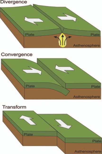
GENERAL ARTICLE

Figure 2.     Major plates
and distribution of earth-   transform faults on the Earth – the San Andreas Fault – forms the
quakes. (Image courtesy:     western boundary between the Pacific and the North American
Dennis Tasa, Tasa Graphic    plates. All of these plate boundaries create earthquakes, and on
Arts, Inc.)                  a map showing the plate boundaries, they are almost overlap. It
                             is to be remembered that a large number of these earthquakes oc-
                             cur in the ocean and do not affect human populations. The larger
                             and more destructive earthquakes occur along the collision zones,
                             such as the Himalaya, Aleutian trench, etc., which are converg-
                             ing plate boundaries. With this general idea of how earthquakes
                             are associated with plate motions, we can now look at different
                             types of earthquakes, their source characteristics, and relation to
                             the respective tectonic settings. See Figures 1, 2 and 3 for a com-
                             prehensive understanding of the ideas discussed above.

                             P, S Waves – Intensity and Magnitude

                             The simplest description of an earthquake is that it occurs as the
                             result of the release of stored elastic energy along certain weak

340                                                                      RESONANCE | March 2018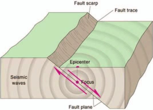
GENERAL ARTICLE

                                                                       Figure 3. Different types
                                                                       of plate boundaries.      (a)
                                                                       Divergent, where plates
                                                                       move apart (b) Convergent,
                                                                       where plates collide, and
                                                                       one plunges beneath another
                                                                       and (c) Transform fault
                                                                       where plates slide past each
                                                                       other without creating or
                                                                       destroying the lithosphere.

zones in the Earth, known as ‘faults’, which are weak planes
formed with the layers of the Earth. The size of an earthquake
is indicated by its magnitude – a measure of the energy released
– and it is computed from instrumentally recorded data. Energy
from an earthquake is released as various types of waves – body
waves and surface waves. P-waves (primary waves) are body
waves that travel through the Earth and are the first to arrive at
a recording station. S-waves (secondary waves) or shear waves
are also body waves, but they arrive a little later than the P-wave.
Interaction of these body waves with the surface of the Earth gen-
erates surface waves (Love and Rayleigh waves), which travel
even more slowly and are responsible for most of the damage.

RESONANCE | March 2018                                                                           341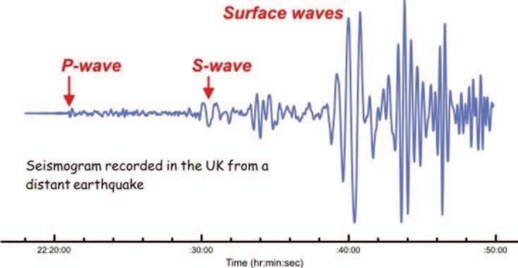
GENERAL ARTICLE

Figure 4.    Record of an
earthquake showing the P, S,
and surface waves.

                               The propagation velocity of seismic waves depends on the density
                               of the medium, and thus it increases as it travels to the deeper
                               layers of the Earth. The velocity of P-wave varies from ∼ 5.5 km/s
                               to 6.5 km/s, and that of the S-wave varies from ∼3.2 km/s to 3.8
                               km/s in the top ∼50 km of the crust. Seismic wave velocities drop
                               as they pass through the base of the lithosphere, which is taken as
                               the evidence for the presence of a partially molten layer, which
                               facilitates the gliding mechanism of the plates. Velocities of P
                               and S waves continue to increase as they enter the mantle, to ∼8
                               km/s and 4.5 km/s, respectively. The core-mantle boundary is at
                               ∼2900 km depth, and the velocity of P-waves gradually increases
                               to ∼11.3 km in the inner core. It is to be noted here that the
                               outer core does not transmit S-waves as it is in a fluid state – an
                               inference based on the inability of the shear wave to pass through
                               such medium.
                               The displacement or velocity of the particle, as the elastic wave
                               propagates through the medium, are converted to signals and are
                               recorded by seismographs (seismograms are the records). Due to
                               their respective velocities as described above, there is a difference
                               in the arrival times of P and S waves at various stations, and this
                               gap in time is taken as an indication of the distance between the
                               respective recording station and the source of the earthquake (Fig-
                               ure 4). The amplitude of the recorded wave, which is a measure of

342                                                                         RESONANCE | March 2018
GENERAL ARTICLE

the energy released, is the basis for calculating the ‘magnitude’ of
the earthquake, and thus its value would remain the same, regard-
less of the place where it is recorded. However, the ‘intensity’ of
an earthquake is calculated based on its effects on the built envi-
ronment, and how it was felt by people and thus and can be quite
subjective. Earthquakes during the post-instrumentation era (late
1960s onwards) are generally assigned specific magnitude values
while the historically known earthquakes are usually assigned an
intensity value.
There is a general misconception that magnitudes of all earth-
quakes are measured using ‘Richter Scale’, which some people,
especially in the media, perceive as some sort of a physical de-
vice. Richter scale, developed in 1935 by Charles F Richter of
Caltech, can be regarded as one way of calculating the magnitude
of an earthquake. In other words, it is an algorithm, originally de-
veloped for recordings at California, which relates the amplitude
of the seismic wave (A) from a specific earthquake with that of a
standard event. Here, the standard event is an earthquake of mag-
nitude 0, recorded by a specific type of instrument, 100 km away
and A0 (Δ) is the amplitude of the recorded wave. Here Δ is the
epicentral distance, which is the distance between the surface pro-
jection of the source of the earthquake and the recording station.
The logarithmic scale implies that an earthquake of magnitude 6
is 10 times larger than that of 5 and it reads as:

                   ML = Log10 A − log10 A0 (Δ),                 (1)

wherein ML is the local magnitude. A is the measured amplitude
of the seismic wave recorded on the seismogram, and A0 (Δ) is the
amplitude of the seismic wave from an earthquake of magnitude
zero, sourced at an epicentral distance of 100 km away from the
specified instrument (Wood Anderson, as chosen by Richter).
Subsequent to the development of the Richter scale, and with
the availability of a large amount of data from global recordings,
there were more developments in computing the magnitude of
earthquakes. Several empirical relationships for magnitude esti-

RESONANCE | March 2018                                                 343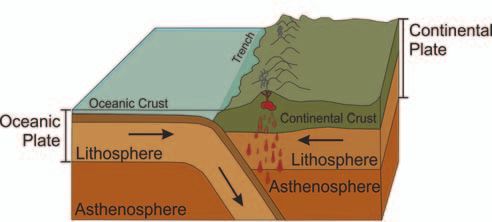
GENERAL ARTICLE

Figure 5. The dimensions
of rupture represent the size
of the earthquake (a) Rup-
ture by a small earthquake
and (b) By a large earth-
quake.

                                mation have been developed by researchers in the later years [2],
                                using both body waves (P or S) and surface waves, designated as
                                mb and Ms respectively. A more recent and widely used measure
                                is the moment magnitude, Mw , which is a closer representation of
                                the earthquake size as it is based on the dimensions of rupture and
                                the elastic properties of the medium. Moment magnitude is cal-
                                culated from the seismic moment, M0 . Thus, M0 = µAD, where
                                µ, A and D are the rigidity modulus, area of the fault that slipped
                                and magnitude of slip, and Mw = 2/3 (log M0 )-10.7. This rela-
                                tion implies a scaling that large earthquakes occur on larger faults
                                with bigger rupture area (see [3] for the theoretical basis) (Fig-
                                ure 5). The US Geological Survey (www.usgs.gov), engaged in
                                global studies of earthquakes has suggested a magnitude classi-
                                fication that considers events of magnitude 8 or more as great;
                                7–7.9 as large; 6–6.9 as strong; 5–5.9 as moderate; 4–4.9 as light,
                                and 3–3.9 as minor.

344                                                                          RESONANCE | March 2018
GENERAL ARTICLE
Figure 6. Parameters of an
earthquake.
Epicentre, Hypocentre, and Hypocentral Depth
The point where the earthquake originates is known as the Earthquakes originate at
‘hypocentre’ and its projection on the Earth’s surface is the ‘epi- a range of depths, from a
centre’, the vertical spacing between the two being the hypocen- few to a few hundreds of
kilometers. Earthquakes
tral depth (Figure 6). Earthquakes originate at a range of depths, originating within 60 km
from a few to a few hundreds of kilometers. Earthquakes origi- depth are considered as
nating within 60 km depth are considered as shallow, and those shallow, and those
sourced within 300 km
sourced within 300 km are considered intermediate. Deeper are
are considered
those sourced > 300 km. Hypocentral depths provide important intermediate. Deeper are
information about the Earth’s structure and the tectonic setting those sourced > 300 km.
where earthquakes are occurring. They also provide information
about the rheology of the source zones, as the brittle to ductile
transitions would tend to limit the seismogenic depths. In the
continental regions, this transition generally occurs at ∼15 km,
where the elastic behavior gives away to partial ductility due to
mineralogical phase transitions caused by changes in temperature
and pressure.
Global data tells us that earthquakes within the continental in-
terior regions, located away from the plate boundaries (like the
peninsular shield of India) are generally shallow. In the subduc-
tion zones, the cold and dense subducting lithospheric slabs re-
RESONANCE | March 2018 345GENERAL ARTICLE
tain their brittle behavior to some depths facilitating earthquake
sources at shallow and intermediate depths. Deeper in the trench,
phase transitions provide conditions favorable for earthquake nu-
cleation, as deep as 647 km, as with the 1994 Bolivia M 8.2 earth-
quake. It is evident from Figure 2 that depth of earthquake foci
increases towards the continental part of the trench, as observed
along all the subduction zones, as indicated by blue, yellow, and
red dots that signify the range in depth. The rheological control
on seismogenesis can also be observed in the pattern of seismicity
along the mid-oceanic ridges (the blue dots that define the ridges
in Figure 2) where molten rocks exist at shallow depths, inhibit-
ing any elastic slip.
Significant Earthquakes in India
The 2004, India and its adjoining areas occupy a very unique status in the
Andaman-Sumatra plate tectonic framework. The northward movement of the In-
earthquake ruptured dian plate and its ultimate collision with the Eurasian plate that
about 1300 km of the
plate boundary and happened about 40 million years ago resulted in the formation
created a transoceanic of the Himalaya (Figure 7). The boundary between these plates,
tsunami. This plate a zone of collision between two continental plates is one of the
boundary has generated most seismically active regions of the world. The plate boundary
large earthquakes in the
past, but none large takes a southward swing and joins the Andaman-Sumatra sub-
enough to create such a duction zone, where the Indian oceanic plate plunges beneath the
tsunami. Eurasian plate forming the Andaman-Sumatra trench. The India-
Eurasia plate boundary has experienced several large (magnitude
≥ 7); great (M ≥ 8) and one mega event (M ≥ 9). Significant
events along this plate boundary are the 1897 Shillong, 1905 Kan-
gra, 1950 Assam, 2005 Kashmir, and 2015 Nepal earthquakes, all
of which were very destructive.
The 2004, Andaman-Sumatra earthquake (Mw 9.2) ruptured about
1300 km of the plate boundary and created a transoceanic tsunami.
This plate boundary has generated large earthquakes in the past,
but none large enough to create such a tsunami (Figure 8). Thus,
there are no historically recorded predecessors for this event, and
it became a challenge to identify the evidence for any previous
346 RESONANCE | March 2018GENERAL ARTICLE
Figure 7. India-Eurasia
plate boundary showing
some of the significant
earthquakes. Two intraplate
earthquakes in 1993 (Kil-
lari) and 2001 (Bhuj) are
also shown.
events. Geological evidences (mostly paleotsunami deposits, sed-
imentary deposits from past tsunamis and preserved in the stratig-
raphy) collected from the coastal regions of Thailand, Indonesia,
Sri Lanka, and India indicate that previous events have indeed
occurred. Combined data from all these shores suggest that the
predecessor of the 2004 tsunami occurred about 500 years back.
Regions away from the plate boundaries also experience earth-
quakes, and these are called intraplate or intracontinental earth-
quakes. Compared to the plate boundary or interplate earthquakes,
these are smaller and infrequent (usually smaller than magnitude
6.5, and spread in time by a few thousands of years, whereas,
the plate boundary events are larger and are spaced over time in-
tervals of a few hundreds of years). The great 1950 Assam and
the 2015 Nepal are typical examples of interplate earthquakes,
whereas, the 1993 Killari (Latur) earthquake is an example of
intracontinental events (Figure 7). It is important to note that
RESONANCE | March 2018 347GENERAL ARTICLE
Figure 8. (A) The 2004
great earthquake which
ruptured about 1300 km
of the Andaman-Sumatra
plate boundary (identified as
white patch) and also gener-
ated a transoceanic tsunami.
This plate boundary and its
adjoining subducting plate
continues to generate large
and great earthquakes. (B)
Cross section of a subduc- (A) (B)
tion zone showing the the
representative location of most intracontinental earthquakes have shallower focus (10–15
the 2004 type earthquake.
km depth) and thus can be very damaging.
Some Highlights from Studies on Earthquakes in India
Our models suggest that Several researchers and organizations are engaged in the stud-
the rupture of the 2015 ies of earthquakes in India, and it is difficult to give a detailed
Nepal earthquake mostly
summary of all these works. Some highlights of the work done
propagated eastward, a
reason why the damage by Kusala and C P Rajendran along with their PhD students and
in the Indo-Gangetic project scientists are highlighted here. These studies are mostly
plains was not severe. on the plate boundary earthquakes – Himalaya, Indo-Burmese
However, its best-known arc, Andaman-Nicobar-Sumatra, and some within the continental
predecessor, the 1934
earthquake, was larger interiors (e.g., 2001 Bhuj, 1993 Killari). Along the Himalaya, the
and its rupture focus has been to understand the mechanism of earthquakes, asso-
propagated southward ciation with tectonic structures and gather information on the past
causing severe damage earthquakes that are not documented. We use the globally avail-
in the Indian plains.
able data to study the earthquakes of the post-instrumentation
period and develop source models to compute their magnitudes,
and understand the rupture pattern and association with tectonic
structures. For example, our models suggest that the rupture of
the 2015 Nepal earthquake mostly propagated eastward, a rea-
son why the damage in the Indo-Gangetic plains was not severe.
However, its best-known predecessor, the 1934 earthquake, was
larger and its rupture propagated southward causing severe dam-
348 RESONANCE | March 2018GENERAL ARTICLE age in the Indian plains. Information on earthquakes that occurred prior to the instrumentation period is extracted from historical records as well as long-lived monuments that might preserve evi- dence of destruction (or lack of it). To further extend the record, one might depend on paleoseismology, which uses geological ev- idence preserved in the shallow stratigraphy, and use coseismi- cally generated fault offsets to develop the chronology of past earthquakes. Using archeological, historical, and geological evidence, we find that the last great earthquake (M > 8) in the Kumaon-Garhwal Himalaya occurred ∼700 years ago. These studies used the doc- umented history of temples, observed damages (or the lack of it) on temples whose construction histories are well-documented and observations in the trenches excavated in various parts of the Himalaya. Admittedly, these studies depend on the authenticity of records as well as finding the right type of evidence from the trenches and thus, the inherent subjectivity in interpretation can be minimized only through extensive studies and generation of a large amount of data. While earthquakes generate signatures of movement along the fault near their sources, evidence for tsunami comes from re- gions near the earthquake as well as distant transoceanic loca- tions. Thus, the reconstruction of tsunami history is mostly based on the evidence of land level changes near the source of the causative earthquakes, and using the tsunami deposits preserved in the strati- graphic records in the near and distant shores. The 2004 Suma- tra earthquake, for example, created significant vertical land level changes along the plate boundary and also deposited tsunami sands along many distant shores of the Indian Ocean rim countries – In- dia, Sri Lanka, Thailand, and Indonesia among them. Such land level changes and tsunami deposits point to the potential repos- itories of its predecessors. The science of tsunami geology, pi- oneered by Brian Atwater of the US Geological Survey is about finding such signatures and developing the history of past events (https://pubs.usgs.gov/pp/pp1707/). Based on the age of the transoceanic tsunami deposits found along the shores of India, RESONANCE | March 2018 349
GENERAL ARTICLE

                              Sri Lanka, Indonesia, and Thailand, the predecessor of the 2004
                              mega-earthquake (M > 9) is believed to have occurred about 600
                              years ago (Rajendran et al., 2013 and references therein). Need-
                              less to say, such information is crucial while planning future de-
                              velopmental activities along the coastal tracts. Lessons from the
                              great 2011 Tohuku (Japan) earthquake, and the ensuing tsunami
                              that caused the Fukushima nuclear plant disaster serves as a grave
                              reminder of the human tragedy due to such events.
                              Earthquakes like the 2001 Bhuj (M 7.6) and the 1993 Killari (M
                              6.3) are less frequent, and their predecessors are inferred to have
                              occurred a few thousands of years ago, leaving none of its im-
                              prints in the documented history. Thus, people living in such re-
                              gions have very little preparation, adding to the severity of dam-
                              age and destruction. At both these locations, it has been noted that
                              most of the damage was from the collapse of poorly engineered
                              structures. As the hypocentres of these earthquakes are shallow
                              (as described earlier for the crustal regions), the energy release
                              is very close to the surface leading to severe damage. The ex-
                              cessive damage at Killari that leveled a whole village was due to
                              a combination of two factors: shallow source (∼5 km) and poor
                              construction. Research also suggests that the conditions of the
                              site (like the presence of soft soil) can amplify the seismic en-
  Research also suggests      ergy, compounding the damage. Thus, the 2001 Bhuj earthquake
that the conditions of the    caused significant damage at Ahmedabad, located more than 200
      site can amplify the    km away from its source. The damage caused to a distant city has
           seismic energy,
         compounding the      highlighted the possibility of site amplification and thus, the mi-
 damage. Thus, the 2001       crozonation of cities, and the study of how each site may respond
 Bhuj earthquake caused       to seismic shaking and how the design of structures have to be
    significant damage at     made, has become an important branch of engineering seismol-
     Ahmedabad, located
 more than 200 km away        ogy.
           from its source.
                              Research and Academics Related to Earthquake Studies in
                              India

                              A detailed summary of the status of research on earthquakes in
                              India would require more than a brief article, but it is important

350                                                                        RESONANCE | March 2018
GENERAL ARTICLE
for aspiring youngsters to know where to go to study geophysics,
and perhaps specialize in the science of earthquakes later. With
chemistry major, and mathematics and physics as subsidiary sub-
jects, I did Applied Geophysics from the University of Roorkee
(now IIT Roorkee), at a time when there were no undergradu-
ate courses in Geophysics. Today there are several universities
and IITs that offer programs in geophysics, starting at the under-
graduate level. Several researchers from national organizations
and universities in India work on earthquakes – the National Geo-
physical Research Institute (NGRI), Hyderabad; National Centre
for Seismology (NCS), New Delhi; Institute of Seismological Re-
search (ISR), Gandhi Nagar; Indian Institute of Technology (IITs
at Kharagpur, Mumbai, Kanpur, Roorkee and more); Jawaharlal
Nehru Centre for Advanced Scientific Research (JNCASR), Ban-
galore; and Indian Institute of Science, Bangalore, among them.
The research is mostly about understanding the structure of the
lithosphere, computation of GPS-based plate velocities and defor-
mation mechanisms, developing source models of earthquakes,
reconstructing the history of earthquakes and tsunamis beyond
the historic periods, assessment of earthquake hazards and dam-
age mitigation. With several earthquakes occurring along the
plate boundaries bordering the north and east of India, these stud-
ies are relevant and important in the context of hazard mitigation.
Can Earthquakes be Predicted?
A question that is often being asked is if earthquakes can be pre- Earthquakes occur as the
dicted. Prediction implies identifying the potential source of a fu- culmination of a series
ture earthquake and suggesting its time of occurrence and likely of complex processes
happening within the
magnitude enabling a warning and evacuation of people. In the Earth, beyond our realm
history of earthquake science, this has happened only once – in of observation. The
the case of the 1975 (M 7.3) earthquake in Haicheng province in challenges in modeling
China wherein people were evacuated and lives were saved. Al- these complicated
processes involving
though this successful prediction offered hope to the scientists, several unknown
the inability to predict a similar size earthquake during the subse- parameters make the task
quent year in the Tangshan province of China demonstrated that of earthquake prediction
very challenging, but the
earthquake prediction remains evasive. The well-planned Park-
efforts continue.
RESONANCE | March 2018 351GENERAL ARTICLE
field earthquake prediction experiment of the late eighties to early
nineties (https://earthquake.usgs.gov/research/
parkfield/general.php) based on the 22-year recurrence his-
tory (during 1857–1966) of a selected segment of the famous San
Andreas Fault also did not find success as the earthquake forecast
for the window 1988–1993 closed without the occurrence of the
predicted event.
Earthquakes occur as the culmination of a series of complex pro-
cesses happening within the Earth, beyond our realm of observa-
tion. The challenges in modeling these complicated processes in-
volving several unknown parameters make the task of earthquake
prediction very challenging, but the efforts continue. However,
today the focus is also shifting towards predicting the effects of
future earthquakes and minimizing damage through better engi-
neering practices and awareness programs. Human race is now
alert to the fact that earthquakes occur as a part of the natural
processes of an active planet that drives its heat engine, sustains
its magnetic field, and set the plates in motion. In other words,
these are to be seen as the rumblings of an active planet; part of a
series of events that makes the Earth different from other planets
and make it home to all forms of life. Earthquakes, just like other
natural processes, have contributed towards building the current
architecture of the Earth, and they would continue to occur. We
cannot prevent them, but can only learn to live with them. The
bright side is that advances in science and technology would help
the human species to cope with earthquakes and minimize their
effects, and prepare them better to accept earthquakes as part of
the natural process that continues to shape the Earth, and keep it
alive and dynamic.
Suggested Reading
[1] P Keary, Keith A Klepeis and Federick A Vine, Global Tectonics (3rd ed), Wiley
Blackwell, p.463, 2009.
[2] H Kanamori, Energy Release in Great Earthquakes, Journal of Geophys-
ical Research, Vol.82, No.20, pp.2981–2987, Bibcode:1977JGR....82.2981K,
doi:10.1029/jb082i020p02981, 1983.
352 RESONANCE | March 2018GENERAL ARTICLE
[3] H Kanamori, Magnitude Scale and Quantification of Earthquakes, Tectono-
physics, Vol.93, pp.185–199, 1983.
[4] Bruce A Bolt, Earthquakes: A Premier, San Francisco, CA: W H Freeman and
Company, 1978.
[5] R M Parameswaran, K Rajendran, Structural Context of the 2015 Pair of
Nepal Earthquakes (Mw 7.8 and Mw 7.3): An Analysis Based on Slip Distribu-
tion, Aftershock Growth, and Static Stress Changes, International Journal of
Earth Sciences, pp.1–14, 2016.
[6] C P Rajendran, K Rajendran, J Sanwal and M Sandiford, Archeological and
Historical Database on the Medieval Earthquakes of the Central Himalaya:
Ambiguities and Inferences, Seism. Res. Lett., Vol.87, pp.1098–1108, 2013.
[7] K Rajendran, R Parameswaran and C P Rajendran, Seismotectonic Perspec-
tives on the Himalayan Arc and Contiguous Areas: Inferences From past and
Recent Earthquakes, Earth-Science Reviews, Vol.173, pp.1–30, 2017.
[8] C P Rajendran, B John and K Rajendran, Medieval Pulse of Great
Earthquakes in the Central Himalaya: Viewing Past Activities on
the Frontal Thrust, J. Geophys. Res. Solid Earth., pp.1623–1641,
http://dx.doi.org/10.1002/2014JB011015.
[9] C P Rajendran, K Rajendran, M Thakkar and B Goyal, Assessing the Previous
Activity at the Source Zone of the 2001 Bhuj Earthquake Based on the Near
Source and Distant Paleoseismological Indicators, J.Geophys. Res. Solid Earth.,
Vol.113, p.B05311, doi:10.1029/2006JB004845, 2008.
[10] C P Rajendran, K Rajendran, V Vanessa Andrade and S Srinivasalu, Ages
and Relative Sizes of Pre-2004 Tsunamis in the Bay of Bengal Inferred from
Geologic Evidence in the Andaman and Nicobar Islands, J. Geophys. Res. Solid
Earth., Vol.118, pp.1345–1362, doi:10.1002/jgrb.50122, 2013.
[11] K Rajendran and C P Rajendran, Seismogenesis in the Stable Continental Re-
gions and Implications for Hazard Assessment: Two Recent Examples from
India, Current Science, Vol.85, No.7.
[12] http://www.iris.edu/hq/inclass/video/tectonic_lithospheric_plates Address for Correspondence
_commonly_confused_with_crust, 2003. Kusala Rajendran
[13] https://en.wikipedia.org/wiki/Crust_(geology) Centre for Earth Sciences
[14] www.usgs.gov Indian Institute of Science
[15] www.iris.edu Bengaluru 560 012, India.
[16] https://earthquake.usgs.gov/learn/glossary/?term=Richter%20scale Email: kusala@iisc.ac.in
RESONANCE | March 2018 353You can also read