East City-Curtis Creek Neighbourhood Action Plan: Living together in nature - In association with: GreenUP
←
→
Page content transcription
If your browser does not render page correctly, please read the page content below

In association with:

East City-Curtis Creek Neighbourhood Action
Plan: Living together in nature
Front matter
© 2019 Peterborough GreenUP Association. All rights reserved.

Action Plan Coordinator and Lead Author
Hayley Goodchild, SUN Program Coordinator, GreenUP

Editorial Team
Heather Ray, Water Programs Manager, GreenUP
Jenn McCallum, SUN Program Coordinator, GreenUP
Brittany Harding, Water Education and Outreach Coordinator, GreenUP
Brianna Salmon, Executive Director, GreenUP
Adriana Gomez, Senior Program Manager, Toronto and Region Conservation
Authority’s Sustainable Neighbourhood Action Program

Sustainable Urban Neighbourhoods Advisory Committee
Melanie Kawalec, City of Peterborough
Ian Boland, City of Peterborough
Phil Jacobs, City of Peterborough
Rob Anderson, City of Peterborough
Christie Gilbertson, City of Peterborough
Jill Bishop, Nourish Project
Donald Fraser, East City-Curtis Creek representative
Meredith Carter, Otonabee Region Conservation Authority
Jennifer Clinesmith, Otonabee Region Conservation Authority
Paul Finigan, Otonabee Region Conservation Authority
Carlotta James, Peterborough Pollinators
Janet Dawson, Peterborough Public Health
Monique Beneteau, Peterborough Public Health
Trish O’Connor, Fleming College
Terri Keough, Peterborough Utilities Group
Andrea Connell, Transition Town Peterborough
Shelley Strain, Trent University and Kawartha Heights representative
Beth Stanley, The Canadian Canoe Museum
Adriana Gomez, Toronto and Region Conservation Authority

GreenUP would like to extend special thanks to those who provided additional
support, including Anne Trudell, Charmalee Sandanayake, Nicole Schleifer,
Andrew Nichols, Leighanne Howard, Rachel Barrington, and Nic Cooper.

SUN’s partner organizations include GreenUP, Toronto and Region Conservation
Authority’s Sustainable Neighbourhoods Action Program, City of Peterborough,
Otonabee Region Conservation Authority, and Nourish.

Funding for this project has been generously provided by the Ontario Trillium
Foundation.
We respectfully acknowledge that GreenUP is located on the Treaty 20 Michi
Saagiig territory and in the traditional territory of the Michi Saagiig and Chippewa
Nations, collectively known as the Williams Treaties First Nations, which include:
Curve Lake, Hiawatha, Alderville, Scugog Island, Rama, Beausoleil, and
Georgina Island First Nations.

GreenUP respectfully acknowledges that the Williams Treaties First Nations are
the stewards and caretakers of these lands and waters in perpetuity, and that
they continue to maintain this responsibility to ensure their health and integrity for
generations to come.

                                          ii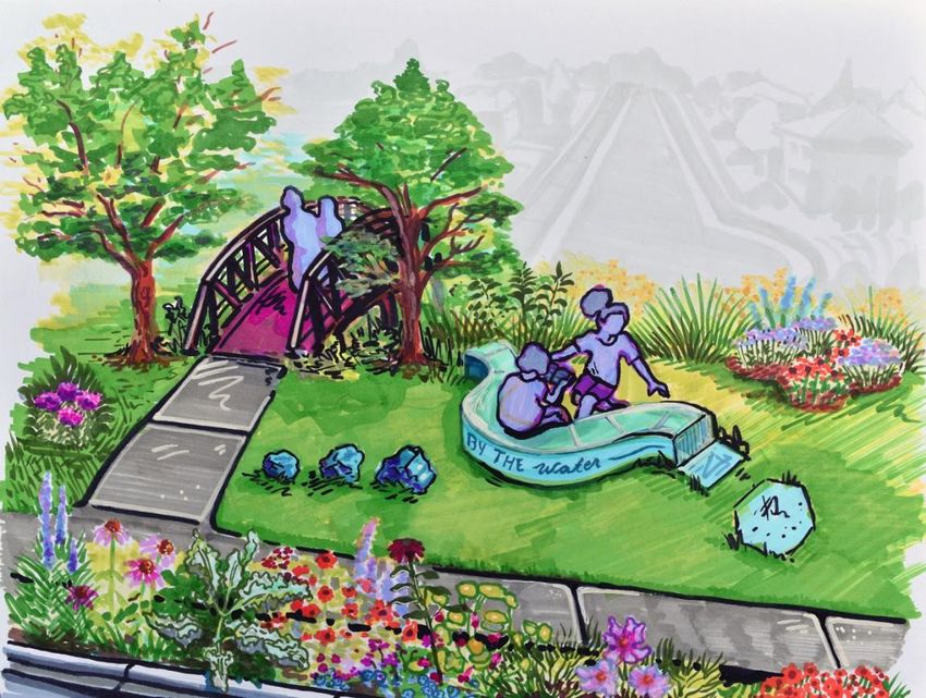
How to use this document
The East City-Curtis Creek Neighbourhood Action Plan is a collaborative ten-
year vision and guide for achieving greater sustainability and resilience to the
impacts of climate change.

This accessible document is intended for municipal staff, other partners,
neighbourhood residents, schools, businesses, and community and faith groups
who wish to review a detailed version of the Plan. A summary version of the
Action Plan is available on the SUN website.

Unless otherwise indicated, all maps in this report use NAD83 UTM 17N
projection and were generated by the author using QGIS 3. Aerial imagery and
data layers courtesy of the City of Peterborough.

                                         iii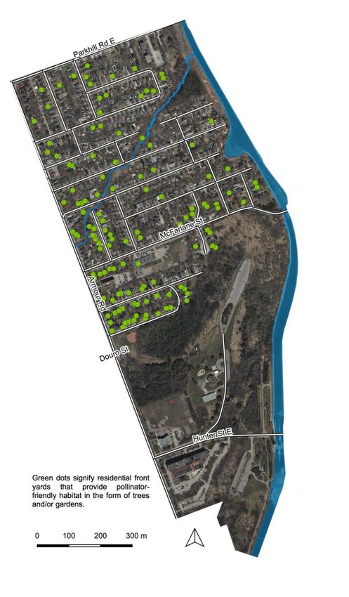
Table of Contents
Front matter ............................................................................................................. i

How to use this document ................................................................................... iii

Executive Summary ............................................................................................. vii

What is SUN?.......................................................................................................... 1

   Introduction ................................................................................................................... 1

   Governance structure .................................................................................................. 1

   Program background and neighbourhood selection ............................................... 2

   Engagement process ................................................................................................... 3

      Phase 1 (2017–2018) ................................................................................................. 3

      Phase 2 (2019) ........................................................................................................... 5

Neighbourhood overview...................................................................................... 7

   Introduction ................................................................................................................... 7

   Summary of neighbourhood baseline conditions .................................................... 8

      Demographics and community values ....................................................................... 8

      Built environment ........................................................................................................ 9

      Transportation ............................................................................................................. 3

      Parks and other community services ......................................................................... 4

      Water ........................................................................................................................... 7

      Urban forest, habitat, and wildlife ............................................................................. 10

Sustainability themes & long-term outcomes .................................................. 13

   Water ............................................................................................................................ 13

   Habitat and urban forest ............................................................................................ 13

   Community resilience ................................................................................................ 14

   Local food security ..................................................................................................... 14

                                                                  iv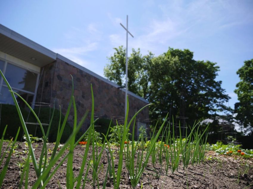
Energy and climate ..................................................................................................... 14

A vision for East City-Curtis Creek.................................................................... 15

   Living Together in Nature – An Introduction ........................................................... 15

   Vision components ..................................................................................................... 15

Focus area 1: Enhance Curtis Creek corridor ................................................. 17

   Vision............................................................................................................................ 17

   How do we get there?................................................................................................. 17

   Sustainability themes addressed ............................................................................. 19

Focus area 2: Create sustainable community spaces .................................... 20

   Vision............................................................................................................................ 20

   How do we get there?................................................................................................. 20

   Spotlight: Armour Heights Public School ............................................................... 23

   Sustainability themes addressed ............................................................................. 24

Focus area 3: Build resiliency and sustainability at home ............................ 25

   Vision............................................................................................................................ 25

   How do we get there?................................................................................................. 25

   Sustainability themes addressed ............................................................................. 29

Focus area 4: Improve streets and trails .......................................................... 30

   Vision............................................................................................................................ 30

   How do we get there?................................................................................................. 31

   Sustainability themes addressed ............................................................................. 34

Successes to date ................................................................................................ 35

   Summary ...................................................................................................................... 35

   Spotlight: Time Square (former Westclox factory) ................................................. 37

Next steps ............................................................................................................. 38

   Implementation ........................................................................................................... 38

                                                                  v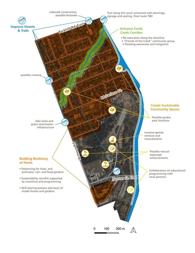
Reporting ..................................................................................................................... 38

References ............................................................................................................ 39

Appendices ........................................................................................................... 42

   Appendix A: Summary of engagement results for East City-Curtis Creek ......... 42

      Engagement results by sustainability theme ............................................................ 44

      Phase 2 (2019) ......................................................................................................... 47

   Appendix B: Guidelines and criteria for selecting recommendations for the SUN
   Action Plans ................................................................................................................ 49

   Appendix C: Determining long-term outcomes ...................................................... 50

      Water ......................................................................................................................... 50

      Habitat and urban forest ........................................................................................... 51

      Community resilience ............................................................................................... 54

      Local food security .................................................................................................... 55

      Energy and climate ................................................................................................... 56

   Appendix D: Summary of SUN Quick-Starts ........................................................... 57

                                                                 vi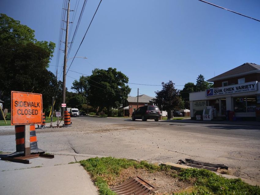
Executive Summary
Living together in nature

East City-Curtis Creek is an eighty-three hectare urban neighbourhood in east
Peterborough. Residents know their neighbours, and appreciate their proximity to
a number of important ecological and cultural sites, including Curtis Creek (which
snakes through the neighbourhood), the Lift Lock and Trent-Severn waterway,
and Armour Hill. Yet, like many urban communities today, East City-Curtis Creek
is characterized by declining biodiversity, vulnerability to flooding, and car
dependency. As climate change intensifies, it is more important than ever that we
reverse these trends and adapt to a warmer and less predictable environment.

In 2017, East City-Curtis Creek was chosen as one of the two pilot
neighbourhoods for the GreenUP Sustainable Urban Neighbourhoods program
(SUN), a three-year initiative that offers an innovative way of making the places
we live, work, play, and learn more sustainable and resilient.

The SUN approach builds widespread support for neighbourhood-scale action by
bringing together residents, the municipality, and partners such as Otonabee
Conservation, Nourish and others, to create an Action Plan tailored to each
community. Since 2017, our partners and hundreds of East City-Curtis Creek
residents and community members identified local needs and shared their ideas
for neighbourhood projects and programs.

The Plan represents a collective vision of what the neighbourhood can become
by 2030 if actions are implemented swiftly and collaboratively, and provides a
roadmap for how to get there. Actions are grouped into four focus areas:

1. Enhance Curtis Creek corridor improves the ecological health of the creek
   through a range of retrofits and cultivate a meaningful and caring human–
   nature relationship between local residents and this unique waterway.

2. Create sustainable community spaces transforms a variety of spaces
   (parks, school grounds, road islands, and more) for enhanced community
   use, increased biodiversity and urban forest canopy, and greater access to
   local food.

3. Build resiliency and sustainability at home transforms residential homes
   and streets through retrofits designed to increase biodiversity and urban
   forest canopy, improve stormwater management and susceptibility to local
   flooding, support local food production, and reduce our collective carbon
   footprint.

4. Improve streets and trails increases pedestrian and cycling infrastructure
   and connectivity, encourages residents to choose active transportation

                                        vii
options, and maximizes proposed capital projects for additional outcomes like
   sustainable stormwater management.

Each recommended action aligns with SUN’s core principles and supports the
long-term outcomes for two or more of the sustainability themes in East City-
Curtis Creek: water; habitat and urban forest; community resilience; local food
security; and energy and climate. The themes and outcomes align as much as
possible with local, regional, federal, and international plans, policies, and goals.

With the planning phases of the project complete, SUN and its partners will be
developing an implementation framework that identifies lead stakeholders,
supporting partners, and next steps for each action. To get involved, visit the
SUN website.

                                         viii
What is SUN?
Introduction
The Sustainable Urban Neighbourhoods program is a three-year initiative funded
by the Ontario Trillium Foundation and led by GreenUP. It offers an innovative
and collaborative way to transform the places we live, work, play, and learn,
making them more sustainable and resilient to the impacts of climate change.
SUN brings together local residents, municipal staff, community groups, and
other key partners to identify ideas and opportunities for change.

In addition to planning, SUN undertakes ‘Quick-start’ demonstration projects that
inspire residents, community groups, and partners to take action by showcasing
possibilities for change. Quick-starts are also opportunities for SUN to engage
with the wider community and build capacity amongst residents to support the
implementation of the Action Plan.

There are two kinds of Quick-starts: high intensity actions and low intensity
actions. The five kinds of high intensity planting options include urban tree
planting, pollinator gardens, rain gardens, food gardens, and native species
plantings. Low intensity retrofit actions include removing invasive species, and
providing rain barrels, composters, bat houses, and birdhouses.

Sustainable Urban Neighbourhoods (SUN) is modelled after Toronto and Region
Conservation Authority’s Sustainable Neighbourhood Action Program (SNAP).
SNAP is a collaborative, neighbourhood-based solution for advancing
sustainable urban renewal and climate action in older urban areas. For more
information, visit TRCA’s SNAP website.

Governance structure
SUN’s work is supported and directed by the SUN advisory committee, which
consists of representatives from the following groups and institutions:

•   GreenUP
•   City of Peterborough
•   Otonabee Conservation
•   Toronto and Region Conservation Authority (TRCA)
•   Nourish Project
•   Peterborough Utilities Group (PUG)
•   Peterborough Public Health (PPH)
•   Peterborough Pollinators
•   Transition Town Peterborough
•   Fleming College
•   Trent University
•   The Canadian Canoe Museum

                                         1
• Kawartha Heights resident representative
• East City-Curtis Creek resident representative
The advisory committee has met six times to review program progress and
advise on community engagement strategies, Quick-start and educational
events, and the proposed content and format of the Neighbourhood Action Plan.
In addition to our advisory committee, the following groups and organizations
have supported and participated in SUN East City-Curtis Creek:
• Local residents
• Schools (Armour Heights Public School and King George Public School)
• St. Luke’s Anglican Church
• Time Square/Westclox complex
• Parks Canada
• Canadian Family Health Collective/Grow Happy program
Program background and neighbourhood selection
SUN is modelled after, and led in association with, the Toronto and Region
Conservation Authority’s Sustainable Neighbourhood Action Program (SNAP).
SNAP is a collaborative, neighbourhood-based solution for advancing
sustainable urban renewal and climate action in older urban areas. In 2017,
GreenUP received a three-year Grow Grant from the Ontario Trillium Foundation
to bring the SNAP approach to Peterborough, a mid-sized municipality outside
the Greater Toronto and Hamilton Area.
In 2017, GreenUP consulted with the City of Peterborough, Sustainable
Peterborough, Otonabee Conservation, the County of Peterborough, and Nourish
to identify priority areas for each partner. Next, GreenUP developed a
neighbourhood selection process adapted from the SNAP model, shortlisted five
neighbourhoods, and selected the final two pilot neighbourhoods. The criteria
used to select pilot neighbourhoods included:
• A minimum area of 1.5km2
• Known vulnerabilities to future climate change impacts (e.g. flood risk)
• Mixed land uses (residential, commercial, institutional, etc.)
• Existing participation in other community projects or initiatives
• Distinctive characteristics from other shortlisted neighbourhoods (e.g.
differences in demographics, density, rates of home ownership, etc.)
• Alignment with local and regional plans and priorities
• Potential to address multiple partner priorities within the neighbourhood
• Sufficient community readiness
East City-Curtis Creek and Kawartha Heights were selected from a shortlist of
five neighbourhoods within the City limits, which also included Bonaccord,
2Talwood, and the Downtown area. A separate report outlining the neighbourhood
selection process is available upon request.
Engagement process
The Neighbourhood Action Plan is based on input from local residents and other
community members, and aligned with the plans and priorities of partners such
as the City of Peterborough, Otonabee Conservation, and others. Overall,
GreenUP staff have recorded 696 engagement interactions with people who live,
work, play, and learn in the East City-Curtis Creek neighbourhood, and held
twenty-nine meetings with partner representatives. There have been two phases
of engagement toward the Action Plan.
Phase 1 (2017–2018)
From late 2017 to late 2018, SUN program staff undertook extensive partner and
resident engagement to expand knowledge on local baseline conditions, and
learn about opportunities and priorities in each neighbourhood. Partners were
engaged through five joint advisory committee meetings, a partner questionnaire
completed by seven partner representatives, and a series of one-on-one
meetings and phone calls between SUN program staff and partner
representatives.
An important component of the SUN model is identifying alignments between
municipal capital projects and planning opportunities and the needs and interests
of the local community. In East City-Curtis Creek, the following municipal and/or
joint stakeholder projects and initiatives have been identified as opportunities to
pursue long-term sustainability objectives identified in this Action Plan.
Capital projects
• Armour Road reconstruction (Clifton Street to Caddy Street) and Curtis
Creek culvert replacement (2018–2019): This a comprehensive
reconstruction project that includes earth excavation, grading, storm sewer,
sanitary sewer, water main, box culvert installation, concrete curb and gutter,
concrete sidewalk and road reconstruction. This project supports some of the
recommendations in the Curtis Creek Flood Reduction Master Plan.
• Curtis Creek culvert replacement at Euclid Avenue (2019–2020): This is a
comprehensive reconstruction project on Euclid Avenue (near Trent Street)
that incudes earth excavation, grading, storm sewer, sanitary sewer, water
main, concrete box culvert, concrete curb and gutter, concrete sidewalk and
road reconstruction. This project supports some of the recommendations in
the Curtis Creek Flood Reduction Master Plan.
• Armour Road reconstruction from Douro Street to Clifton Street:
Pending budget approval, this future road reconstruction project will support
recommendations in the Curtis Creek Flood Reduction Master Plan.
3• Curtis Creek channel improvements: Pending funding, this future project
will complete additional channel improvements recommended under the
Curtis Creek Flood Reduction Master Plan.
• New East City school (2019–2020): Armour Heights and King George Public
Schools are amalgamating. Construction is underway on a new East City
school on Hunter Street East, between the existing King George Public
School site and Museum Drive. The new East City School will serve
approximately 675 students, kindergarten to grade 8, as well as a French
immersion program, and childcare centre. It is scheduled to open in 2020.The
King George and Armour Heights properties could become opportunities for
sustainability projects and programming once construction of the new school
is complete, and depending on the future use of these sites.
• Trent-Severn Waterway berm reconstruction (2018–2019): Parks Canada
is undertaking work along the canal’s earthen embankments to stabilize the
structure and reduce the risk of flood damage along the corridor. There may
be opportunities to collaborate with SUN on re-naturalization.
Planning and policy projects
• Municipal Parks and Open Space Review (2018–2019): The key objectives
of this review are to establish planning and design guidelines for parks,
evaluate existing parks and identify those requiring improvements, and
identify and address gaps in access to neighbourhood parkland.
• Our Watershed, Our Blueprint (2019–2021): The key objective of this
municipal project is to provide a framework to assist the City in the protection
and management of water resources.
• City of Peterborough Official Plan (2020): In 2011, the City of Peterborough
began preparing a new Official Plan to direct municipal growth and operations
until 2041. At the time of writing, the draft Official Plan was made available to
the public for review.
• East Side Transportation Study (2019–2020): In the fall of 2019, the
municipality is expected to contract a consultant to conduct an East Side
Transportation Study as part of the process toward the development of
Ashborough Village, a subdivision development just southeast of the
neighbourhood (across the canal). This study “will review all modes of travel
and develop recommendations to improve transportation services for areas
east of the river to ensure the study area efficiently connects to the rest of the
City” (City of Peterborough, 2019c).
• Transition 2050 (2019–2021): In 2019, TRCA received funding from the
Federation of Canadian Municipalities to work with nine municipalities,
including Peterborough, as they develop residential- and/or business-focused
climate action plans at the neighbourhood level. The lessons learned from
this collaborative initiative will help to refine, mainstream, and scale TRCA’s
neighbourhood model as a means of implementing climate action plans and
achieving other municipal and regional objectives. There may be
4opportunities to connect this initiative with the work already underway in the
SUN neighbourhoods.
• Curtis Creek Floodplain Mapping Project (2020): In 2020, Otonabee
Conservation will release floodplain maps for the Curtis Creek watershed,
including updated regulatory flood limits and raster-based risk maps. The
updated floodplain data will help inform the development of an evidence-
based floodproofing and awareness program proposed in Actions 1c and 3c
below.
GreenUP staff engaged the neighbourhood in five main ways during Phase 1: (1)
one-on-one meetings; (2) online surveys; (3) Quick-start garden installation
events; (4) outreach and educational events organized through the SUN program
(such as ‘planning potlucks’ and ‘kitchen table conversations’); and (5) events
organized by others in the community.
Notes from these engagement opportunities were coded using tags such as
‘flooding,’ ‘biodiversity,’ and ‘pedestrian safety’. These codes were then used to
determine the top sustainability themes or priorities in each neighbourhood,
which are outlined in the Sustainability Themes and Long-Term Outcomes
section.
For an extended summary of the engagement results from Phase 1, see
Appendix A: Summary of engagement results for East City-Curtis Creek.
Phase 2 (2019)
In 2019, SUN shifted from general engagement about sustainability priorities,
needs, and opportunities in East City-Curtis Creek to soliciting specific actions
toward solutions and program suggestions for the Action Plan.
SUN organized two Action Plan Gatherings in early 2019 to solicit input from
residents and partners. The first of these took place on January 23 rd 2019 at the
McDonnel Street Activity Centre. This event brought together forty-five
participants who represented partners and residents from both neighbourhoods.
Four of the attendees were residents and/or community representatives from
East City-Curtis Creek. Ideas for the Action Plans were generated using a series
of interactive, small-group activities designed by Christie Nash, a local consultant
with extensive experience conducting community engagement and event
facilitation.
A second follow-up Gathering was held in East City on March 4th 2019. Twenty-
seven residents and community members attended. This event provided a free
meal and drop-in style Action Planning activities. The goal was to build on the
ideas identified during Phase 1 of engagement and at the Action Plan Gathering
in January. GreenUP staff invited residents to provide feedback on proposed
ideas and identify additional ones. Data was captured using modified versions of
the activities developed for the first Gathering.
5A full report on data collected at these two Gatherings is available upon request.
Once a list of potential actions and program ideas was created, GreenUP staff
grouped them into focus areas using an inductive approach, and compared these
with categories recommended by the consultant in her final report. Next, each
action was assessed according to SUN advisory committee criteria to determine
whether it should be included in the Action Plan. Ideas that met the greatest
number of criteria were included. In some cases, actions were merged and/or
modified to better suit local conditions and opportunities, reflect best practices
and scientific knowledge, or better align with partner priorities in the
neighbourhood. See Appendix B: Guidelines and criteria for selecting
recommendations for the SUN Action Plans for further details.
Since June 2019, GreenUP staff have been soliciting resident and partner
feedback on the first draft of the Neighbourhood Action Plan. For an extended
summary of the engagement results, see Appendix A: Engagement summary for
East City-Curtis Creek.
6Neighbourhood overview
Figure 1. Map of East City-Curtis Creek. Image by GreenUP.
Introduction
East City-Curtis Creek is a mid-sized neighbourhood nestled between Parkhill
Road in the north, the Trent-Severn Waterway in the east, Hunter Street East in
the south (including Time Square/Westclox and the proposed Canadian Canoe
Museum site), and Armour Road in the west. The majority of residents live on the
north side of Armour Hill, where Curtis Creek snakes through the neighbourhood.
Long before it was known as Curtis Creek, the Michi Saagiig Nishnaabeg shaped
and cared for the forests, waterways, and wetlands in this area. In the nineteenth
7century, European settlers took the land and cleared it for agriculture. In 1858 the
area was incorporated as the Village of Ashburnham, which was annexed in turn
by the City of Peterborough in 1903. In 1913, the local landscape was
dramatically altered with the opening of the Lift Lock and Trent-Severn
Waterway, which established the neighbourhood’s current eastern border.
Today, East City-Curtis Creek is home to just over 1500 residents and some of
the city’s most significant cultural and ecological sites, including Armour Hill,
Peterborough Museum and Archives, the Lift Lock (a National Historic Site of
Canada), and the former Westclox factory (now a mixed residential and
commercial building called Time Square). Because of East City-Curtis Creek’s
residential density, ample green space, and proximity to local waterways, it has
an important role to play in modelling how urban residents can live sustainably
with nature and become more resilient to climate change.
Summary of neighbourhood baseline conditions
Demographics and community values
There were 1528 people and 419 family households in East City-Curtis Creek in
2018. The average household size is 2.2 people and the median individual age is
38 (City of Peterborough, 2019a).
Most neighbourhood residents are Caucasian, English speaking, and Canadian-
born. Only 4.5% of neighbourhood residents are immigrants (Environics
Analytics, 2017) compared to 9% for the city as a whole (Government of Canada,
2016), and 0.8% of residents belong to a visible minority group (Environics
Analytics, 2017) compared to 6.1% for the city (Government of Canada, 2016).
Note that this data does not include residents at the Time Square/Westclox
complex, who were added when the SUN boundaries were adjusted in 2018.
According to Environics Analytics (2017), the average household income for East
City-Curtis Creek is $78,211, slightly above the City of Peterborough’s average
before-tax household income of $73,774 in 2015 (Government of Canada, 2016).
However, the report does not include data for residents of Time
Square/Westclox. The average before-tax household income for the census
dissemination area that includes Time Square was $43,098 in 2015. Hence the
average before-tax household income for the entire neighbourhood is likely lower
than that reported by Environics Analytics.
According to Environics Analytics (2017), East City-Curtis Creek residents value
multiculturalism, ethical consumerism, and ecological lifestyles. Many enjoy
outdoor activities like camping, gardening, hiking, swimming, and team sports,
and an estimated fifty-three per cent of residents volunteer for different causes.
These residents may take particular interest in home, garden, and community-
based retrofit projects like those presented in this Plan. The experience of
8GreenUP staff working with residents and volunteers to install Quick-start
demonstration gardens further supports this analysis.
Built environment
Land use in East City-Curtis Creek consists of residential areas (53%),
commercial areas (6%), and major open space (41%).
The commercial area consists of offices in the Time Square/Westclox complex
on Hunter Street East. There are also two businesses along Armour Road in the
residential area of the neighbourhood, including Steve’s Quik Chek, a popular
convenience store, and Urban Space, a lifestyle store and café that opened in fall
2019. The East City commercial strip is located west of the neighbourhood along
Hunter Street East, and includes a number of restaurants, medical and beauty
services, post office, and more.
Fifty-three per cent of the neighbourhood is residential. Excluding Time
Square/Westclox, 78% of households own their homes, and 22% rent (Environics
Analytics, 2017). There are a few low-rise apartment complexes in East City-
Curtis Creek, including apartment buildings on Parkhill Road East near the canal,
the Time Square/Westclox complex on Hunter Street East, and a six-unit building
on Caddy Street. Plans are underway to expand the Time Square residential
complex with two additional buildings on the existing property (Kovach, 2019).
There are also a number of single-family homes in the neighbourhood that have
been divided into apartments, including a large historical building on Welsh
Street.
The average residential dwelling is 57 years old, which corresponds with
observations by GreenUP staff that detached wartime bungalows are the
dominant dwelling type in the neighbourhood. There are also a number of older,
two-storey brick homes, some of which may have been constructed in the late
nineteenth and early twentieth centuries. See Table 1 for a breakdown of
dwellings by type.
9Table 1. Percentage of dwellings by type (excluding Time Square/Westclox
complex)
Single Semi- Row Apartment Apartment Apartment
detached detached house in a flat or in building in a
duplex more than building
five less than
storeys five
storeys
78% 1% 3% 6% 0% 12%
Source: Environics Analytics, 2017
Detached residential properties in East City-Curtis Creek have an average lot
size of 551 square metres (City of Peterborough, 2018f). Most properties have
lawns and modest ornamental landscaping, although the amount of space
available depends on the size of the home, and whether there is a garage, shed,
and/or pool. Generally, lawn and garden spaces in the neighbourhood are
modest in size, with backyards being larger than front yards.
In the fall of 2018, GreenUP staff collaborated with Peterborough Pollinators and
community residents to conduct an inventory of pollinator habitat in front yard
gardens and public spaces. The study found that roughly a quarter of all
residential properties have pollinator-friendly trees and plants (see Figure 2). The
top ten pollinator-friendly trees and plants identified were:
1. Maple (spring bloom)
2. Sedum (fall bloom)
3. Goldenrod (fall bloom)
4. Aster (late summer/fall bloom)
5. Milkweed (late summer bloom)
6. Yarrow (late summer bloom)
7. Mulberry (spring bloom)
8. Crab apple (spring bloom)
9. Phlox (spring/early summer bloom)
10. Bee balm (early/late summer bloom)
The data suggests residential properties provide fewer spring and early summer
pollinator plants than late summer and fall species, though the timing of the
inventory (in October) might have biased results toward late-blooming plants. A
follow-up inventory in the spring or early summer as well as an inventory of
backyards would provide additional data on gaps in spatial and seasonal
coverage.
1Figure 2. Map identifying results of the SUN–Peterborough Pollinators Front
Yard Inventory in fall 2018.
2Transportation
According to Environics Analytics (2017), 68.6% of residents commute to work by
car as a driver, 14.0% commute by car as a passenger, 6.5% use public transit,
6.7% walk, and 2.4% cycle. However, the Environics data does not include
residents of Time Square/Westclox, many of whom do not own cars and use
active transportation regularly.
Major transportation corridors exist on three sides of the neighbourhood due to
the presence of the Trent-Severn Waterway. Armour Road is the main north-
south corridor. Many residents have expressed concern about pedestrian and
cycling safety along Armour Rd, especially when crossing at Nicholl’s Oval,
Steve’s Quik Chek, and Douro Street (see Figure 3). There are three
thoroughfares in the neighbourhood that cross the Trent Canal: Parkhill Road,
McFarlane Street, and Hunter Street East. Of these, only Parkhill Road permits
both directions of traffic to cross the canal at once.
Figure 3. Intersection at Armour Road and Dufferin Street near Steve’s Quik
Chek. Photo by GreenUP.
Sidewalks in the neighbourhood are inconsistent, often ending suddenly, or are
only featured on one side of the street. According to the City of Peterborough’s
Strategic Sidewalk Plan (2016), there are 273m of priority 1 missing sidewalk
3segments in the neighbourhood (the south side of Parkhill Road), and 386m of
priority 2 missing sidewalk segments (including north and south sections of
Parkhill Road, parts of Armour Road, and the north side of Hunter Street East,
near the Lift Lock). There are additional missing segments of lesser priority on
some residential streets.1
There is currently no formal cycling infrastructure in East City-Curtis Creek. The
municipality’s Comprehensive Transportation Plan (2012) identifies McFarlane
Street as a proposed on-road cycling route, and the west side of the Trent-
Severn waterway as a potential off-road cycling route. The municipality and
Parks Canada recently held an open house to collect feedback from residents
about the proposed Canal Trail route, which would connect Lock 19 in the south
end of the city with the area north of Parkhill Road East.
Two buses provide service to the neighbourhood. The #9 (Nicholl’s Oval) runs
north along Armour Road between Douro Street and Parkhill Road, and south
from Parkhill Road East to Dufferin Street, where it heads west toward Rogers
Street. The #11 (Ashburnham) runs east and west along Hunter Street East,
connecting the neighbourhood to areas on the east side of the canal. Both buses
connect the neighbourhood with the downtown bus terminal. The Trent Express
(East Bank) runs just north of the neighbourhood, with a stop at Parkhill Road
East and Armour Road.
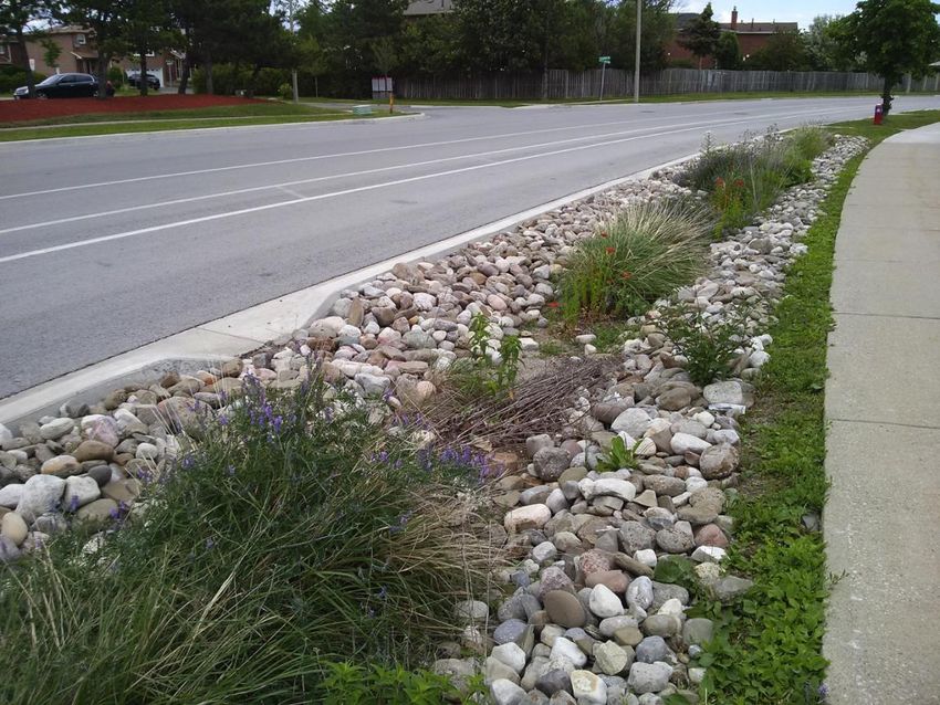
Parks and other community services
Forty-one per cent of the neighbourhood is parkland and open space. The main
green space is Ashburnham Memorial and Rube Brady Parks (colloquially known
as ‘Armour Hill’), a twenty-hectare site with informal walking trails, the
Peterborough Museum and Archives, multiple children’s playgrounds, a baseball
diamond, sledding hill, and impressive views of downtown Peterborough.
Community groups and First Nations often use this space for events, gatherings,
and education. There is also green space south of Hunter Street East.
Just west of the neighbourhood is another major park, Nicholl’s Oval, which
many residents use for its playground, splash pad, sports fields, and pavilion,
and to attend events like the annual Peterborough Folk Fest. However, residents
report that traffic and lack of pedestrian-friendly infrastructure on Armour Road
make it difficult to access the park safely. Despite the number of parks in the
area, an initial assessment by the Municipal Parks and Open Space review
1 During the Sidewalk Strategic Plan update, municipal staff assessed each segment of missing
sidewalk according to a list of thirteen criteria (such as type of road, proximity to school zones,
and more). Segments receiving 145 points or greater were designated priority 1, and segments
awarded 105–140 points were designated priority 2. The municipality estimates that it will take
until 2024 to build “most of the remaining priority 1 and priority 2 sidewalks” (City of
Peterborough, 2016, p.13).
4(2019b) indicates there is a sizeable residential area in the east part of the
neighbourhood (between Juliet Road and Welsh Street) that does not fall within
400m of an existing neighbourhood park. The municipality recommends 400m or
less between residences and parkland for resident health and well-being.
The neighbourhood offers a number of unique cultural services and program
opportunities for residents and visitors. Peterborough Museum and Archives is
located at the top of Armour Hill in Ashburnham Memorial Park. This City-owned
facility offers regular programming and exhibits, as well as opportunities to do
local historical research. There is also an outdoor play structure and a pavilion
next to the Museum, which is used for a variety of events and everyday activities.
The historic Lift Lock and Trent-Severn Waterway are popular tourist spots that
are connected to the neighbourhood via informal walking trails along the east
side of Ashburnham Memorial Park. In 2022, the future Canadian Canoe
Museum will be opening its new location just south of the Lift Lock, which will
provide both tourists and local residents with further educational and recreational
opportunities.
St. Luke’s Anglican Church, located at 566 Armour Rd., is the only faith institution
within the neighbourhood. In addition to its parish services, the building houses
Trent Childcare, a food bank, community meeting space used by local Girl Guide
and Scout groups, and a thrift shop that is open to the public on Fridays and
Saturdays. A community garden was established on the front lawn of the church
in May 2019 through a partnership between residents, the SUN program, and
Nourish (Figure 4).
5Figure 4. Community garden plots in front of St. Luke’s Church. Photo by
GreenUP.
Currently there are two schools within the neighbourhood: King George Public
School (K–6) and Armour Heights Public School (K–8). A new school is under
construction adjacent to King George on Hunter Street East. Existing schools are
both scheduled to close and amalgamate once the new East City School is
completed in 2020. The closest secondary school is Thomas A. Stewart
Secondary, located approximately 1.5kms north of the neighbourhood on Armour
Road. Trent University is located nearly five kilometres north of the
neighbourhood.
There are limited places to purchase groceries within East City-Curtis Creek.
Steve’s Quik Chek on Armour Road is a popular convenience store that serves
approximately 200 people per day, but does not sell fresh produce. The closest
full-service grocery store is Foodland, located 210m from the southwest corner of
the neighbourhood. There are also specialty food shops located west of the
neighbourhood in the East City Ashburnham Village Business Improvement
Area, including a butcher and a health food store. Some residents have noted at
SUN events that they prefer to shop at downtown grocery stores like Freshco or
No Frills because they are more affordable.
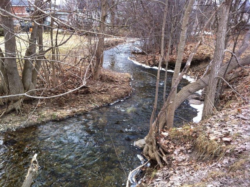
6Water
The 83-hectare neighbourhood of East City-Curtis Creek lies almost entirely
within the Curtis Creek watershed, a 921-hectare area that extends well beyond
the City limits and flows beneath the Trent-Severn waterway via a culvert. The
majority of the Curtis Creek watershed that is downstream of the canal falls
within the neighbourhood boundaries. The predominant soil type found in and
around the Curtis Creek watershed is Otonabee loam type B, which is common
to the Peterborough area and is generally well draining. Urban sections of the
creek have been “significantly altered” through realignments and channelization
(AECOM, 2010). Some channels run very close to city streets, such as the
stretch near Euclid Avenue (see Figure 5).
Figure 5. Curtis Creek south of Euclid Avenue. Photo by GreenUP.
Parts of the neighbourhood were heavily impacted by the 2004 flood (AECOM,
2010). Otonabee Conservation is currently updating floodplain modelling for
Curtis Creek. Once municipal work to widen and rechannel some of the culverts
along Curtis Creek is complete in 2020, up-to-date floodplain boundary maps will
be released. The municipality’s work is expected to reduce or eliminate the
backwater effect caused by insufficient culvert capacity in the event of a 100-year
storm.
Approximately 35% of the total surface area in East City-Curtis Creek is
impermeable (City of Peterborough, 2019c). Environment Canada (2013, p. 53)
recommends a maximum of 10% imperviousness in urbanized watersheds.
7Stream quality is typically “severely impaired” once an urban watershed exceeds
30% (Environment Canada, 2013, p. 53). Impermeable surfaces do not absorb
rainwater, which instead becomes run-off that is managed through the municipal
storm sewer system. Too much run-off disrupts the natural water balance,
reduces water quality in creeks and rivers, and can cause localized urban
flooding, especially if the municipal storm sewer system capacity is insufficient.
The Curtis Creek Flood Reduction Master Plan identified multiple sections of the
local storm sewer system with insufficient capacity for a 5-year rainfall event
(AECOM, 2010).
The combination of impermeable surfaces and insufficient storm sewer capacity
means there are a number of pockets within the neighbourhood that are at risk of
urban flooding during 100-year storms (see Figure 6).2 These types of
precipitation events are expected to increase in frequency as climate change
intensifies (ICLEI Canada, 2018). These areas include (AECOM, 2010):
• North side of Munroe Avenue and east side of Armour Road between Munroe
Avenue and Carlisle Avenue
• East end of Carlisle Avenue, just west of Knox Street
• Low areas on the east side of Armour Heights Public School property, and
backyards of homes on the north side of Carlisle Avenue, adjacent to the
school boundaries
• Areas along Beverly Street between Caddy Street and Welsh Street
• South side of Caddy Street just east of Armour Road
• Armour Road between Woodbine Avenue and just north of Swanston Avenue
• Woodbine Avenue between Armour Road and Trent Street
• Curtis Road between Woodbine Avenue and Swanston Avenue
• Swanston Avenue between Curtis Road and Snelgrove Road, as well as
backyards between Swanston Avenue and Juliet Road
• Backyards between Juliet Road and Parkhill Road
• The southernmost end of the future Canadian Canoe Museum site, near the
canal
Stormwater runoff also negatively impacts water quality in the creek. The
municipality’s Stormwater Quality Master Plan Project Report found that samples
taken from Curtis Creek during wet weather experienced higher than
recommended levels of aluminium, chromium, copper, iron, zinc, total
phosphorous, E. coli, and total suspended solids that were attributable to urban
run-off (XCG Consultants, 2014).
2A 100-year storm is a precipation event (rain and/or snow) with a probability of occurrence of
one per cent in any given year (Otonabee Conservation, 2015, p. 106).
8Figure 6. Map of neighbourhood showing the 30m riparian buffer recommended
by Environment Canada and Otonabee Conservation, as well as urban flooding
hotspots.
Another important waterway in the neighbourhood is the Trent-Severn Waterway,
which was built in the early twentieth century to facilitate commercial and
industrial activity in the area. It is managed by Parks Canada. Today, the canal
forms the easternmost border of the neighbourhood. Many residents appreciate
this area as a space to swim and walk their dogs. In 2018, Parks Canada began
work along the earthen embankments to address the impact that tree roots were
having on the stability of the canal structure. They have begun to replant areas
9where trees were removed with a variety of native grass and wildflower species
(Parks Canada, n.d.).
Urban forest, habitat, and wildlife
The urban forest canopy cover in East City-Curtis Creek neighbourhood is
estimated to be 40%, largely because of Ashburnham Memorial Park, which is
heavily forested. The percentage of canopy cover is estimated at 65% in local
parks and other open spaces and 26% in residential and commercial areas
(Sandanayake, 2019, based on 2015 aerial imagery).
The municipality recommends that no single genus represent more than 20% of
the urban forest canopy (City of Peterborough, 2011). More than 75% of the
existing City-owned trees in the neighbourhood consist of just two genera:
maples at 49.3% and ash at 25.8% (City of Peterborough, 2019d). Although this
data does not include privately owned trees, it is safe to assume that biodiversity
in the East City-Curtis Creek urban forest can be improved, which will make it
more resilient to the impacts of climate change and destructive pests and
diseases. Many City-owned ash trees are already threatened by the emerald ash
borer; of the 100 local ash trees inventoried by the municipality in 2019, 25 are
being treated for ash borer, 51 are being monitored for size, structure, and
health, and 24 are slated for removal and replacement with non-ash species (City
of Peterborough, 2019c).
Much of today’s neighbourhood canopy cover is found on Armour Hill, which was
nearly treeless when the Ashburnham Women’s Patriotic League purchased the
site in the 1920s. They planted hundreds of trees to establish Ashburnham
Memorial Park for soldiers who died in the First World War (see Figure 7). Today,
native trees and other vegetation in this important urban park are being
threatened by invasive species such as dog strangling vine and European
buckthorn.
10Figure 7. Aerial photo of Armour Hill, facing northwest, ca. 1950, Parks Studio
fonds, P-12-665-1. Photo courtesy of Peterborough Museum and Archives.
Systematic data on native wildlife and vegetation within the neighbourhood is
limited. As part of the Curtis Creek Flood Reduction study, AECOM (2010)
reported 123 bird species, 28 mammal species, and 52 families of plants within
the Curtis Creek watershed in 2004. A 2008 survey of the Peterborough Museum
& Archives Property and its immediate surroundings reported 88 plant species, 2
amphibian species, 23 bird species, 1 fish species, and 1 insect species
(Peterborough Field Naturalists).3
More recently, anecdotal and citizen science observations suggest that many
birds, including species at risk, rely on habitat areas within and near the East
City-Curtis Creek neighbourhood. eBird, a citizen science program managed by
Cornell University’s Lab of Ornithology, allows citizen scientists to identify,
photograph, and post bird species observations online. When birds are identified
in unexpected regions, or if unusually large numbers of rare birds are observed,
regional bird experts review the records for accuracy (Cornell University, n.d.-a).
3 The primary focus of this survey was to catalogue bird species, but volunteers also noted a
number of other wildlife and plant species. They did not survey the entirety of Armour Hill. The
final report notes that the group surveyed the immediate perimeter of the buildings and up to 90m
away, depending on the direction.
11According to an eBird search conducted by GreenUP staff in 2019, 109 bird
species have been observed at Armour Hill in the past ten years, including
several species at risk (MNRF, 2018), such as:
• Barn swallow, Hirundo rustica (threatened), observed 27 April 2017
• Bobolink, Dolichonyx oryzivorus (threatened), observed 15 May 2015
• Canada warbler, Cardellina canadensis (special concern), observed 16 May
2015
• Chimney swift, Chaetura pelagic (threatened), observed 16 May 2016
• Eastern wood-pewee, Contopus virens (special concern), observed 20 May
2017
12Sustainability themes & long-term outcomes
SUN identified the following sustainability priorities for partners and residents
during Phase 1 of the engagement process. There are five priority themes in
East City-Curtis Creek. The themes are described below, along with long-term
outcomes for each. As much as possible, these outcomes align with municipal
and regional level goals, plans, and targets. All targets are set for 2030 unless
otherwise indicated. An explanation of how each outcome was generated is
available in Appendix C: Determining long-term outcomes.
Water
Water includes water conservation, urban and riverine flooding, management of
the municipal stormwater system, and the ecological well-being of the Curtis
Creek watershed. Long-term outcomes include:
• Improvements to permeability, watershed health, and local flooding by:
o Reducing paved surface area in the neighbourhood by 800m2
(0.08ha), from the 2018 baseline of 29ha;
o Increasing the amount of rainwater managed where it falls on
residential, institutional, and commercial properties. Work toward
the 90% runoff volume control target recommended by the Ministry
of Environment and Climate Change (now Ministry of the
Environment, Conservation, and Parks) in 2016, which equals the
first 27mm of a rain event in Peterborough.
• Greater resilience to flooding in areas prone to urban and riverine flooding,
indicator TBD.
• Improvements to water quality in Curtis Creek from baseline levels reported in
the municipality’s Stormwater Quality Master Plan (2014).
Habitat and urban forest
Habitat and urban forest includes the biodiversity and well-being of natural
ecosystems in the neighbourhood. Long-term outcomes include:
• Expansion and diversification of the urban forest by planting 365 new trees,
with 152 on residential properties. Prioritize, where appropriate,
underrepresented species recommended by the City of Peterborough.
• Greater biodiversity, by adding 1500 square metres of habitat for pollinators
and other wildlife by 2030, in addition to any gains from the proposed
Canadian Canoe Museum green roof. Fifteen hundred square metres is the
equivalent of nearly 3.5 NBA basketball courts, or one NHL hockey rink!
13Community resilience
Community resilience includes the relationships and infrastructure that support
community building and healthy people, including healthy, active transportation
and recreation. Long-term outcomes include:
• Twenty-five per cent of East City-Curtis Creek residents commuting by public
transit, walking, or cycling (up from Environics Analytics baseline of 15.6%),
by enhancing active transportation infrastructure and supporting residents to
choose active transportation options.
• Enhancement of local outdoor spaces for inclusive and healthy recreation and
community building, with 100% of local parks meeting or exceeding the
minimum required design features for each park type as identified in the
Municipal Parks and Open Space review.
• Greater sense of community belonging amongst residents, measured through
qualitative feedback and/or survey data where available.
• Greater environmental awareness and capacity for local environmental
action, to be achieved by increasing the number of environmental events,
initiatives, and participants each year.
Local food security
Local food security includes the availability of and access to fresh, affordable,
nutritious, and culturally appropriate food in the neighbourhood. Long-term
outcomes include:
• Expansion of space available for producing local food by 2030, specifically an
additional 1000m2 in the form of community garden plots, neighbourhood fruit
and nut trees, and self-reported residential food gardens.
• Greater ability of residents to produce, harvest, and prepare local food,
measured through qualitative feedback and/or survey data where available.
Energy and climate
Energy and climate includes how we heat and power our homes, schools, and
businesses on a daily basis, and the greenhouse gas emissions (GHGs) we
produce through travel and waste. Long-term outcomes include:
• Progress toward the Climate Change Action Plan target of reducing
community GHGs by 30% from 2011 baseline levels by 2031 (Sustainable
Peterborough, 2016), to be achieved by:
o Implementing energy efficiency and conservation measures at 40% of
homes in the neighbourhood (approximately 280 dwellings, not including
the Time Square/Westclox complex);
o Implementing retrofits in 60% of industrial, commercial, and institutional
facilities in the neighbourhood.
14You can also read