EKI TECHNICAL PRESENTATION - COSUMNES SUBBASIN GSP DEVELOPMENT 04 DECEMBER 2020 SURFACE WATER ADVISORY STAKEHOLDER GROUP MEETING - SGMA in the ...
←
→
Page content transcription
If your browser does not render page correctly, please read the page content below
Draft – For discussion purposes only

                                       EKI TECHNICAL PRESENTATION
                                         COSUMNES SUBBASIN GSP DEVELOPMENT

                                                         04 DECEMBER 2020
                                         SURFACE WATER ADVISORY STAKEHOLDER GROUP MEETING

                                                                                            1
Draft – For discussion purposes only

                                       PRESENTATION OUTLINE

            ¡ Feedback from SWAG Meeting #2
            ¡ Groundwater Dependent Ecosystems (GDEs) Verification Study
            ¡ Sustainable Management Criteria (SMCs) Interconnected Surface
              Water (ISW)
            ¡ Historical Basin Water Budget
            ¡ Projects and Management Actions

                                                                              2
Draft – For discussion purposes only

                   COMMENTS FROM SWAG MEETING #2
    q Coordinated monitoring with South American Subbasin.
    q Domestic well water supply and quality.
    q Interconnected Surface Water monitoring and approach to SMCs.
           - Monitoring network and approach
           - Baseline (and MOs) that ensures sustainability (average 2005-2015 or longer)
           - Uncertainty regarding Disconnected vs. Connected vs. Transitional reaches of
                 the Cosumnes River
           - Potential climate change effects
    q Undesirable results for the basin.

                                                                                            3
Draft – For discussion purposes only

        GDE VERIFICATION STUDY(1 OF 4)
    GeoSystems Analysis, Inc (GSA) is conducting desktop
    study to design field verification effort (scheduled for
    late February)
    ¡ Subdivided basin into subareas for focused analysis
           - Group by water sources and land use
           - Hydrogeologic conditions (TM#6)
           - Target key areas for field work
    ¡ Natural Communities Commonly Associated with
          Groundwater (NCCAG) health assessment (e.g.,
          greenness trends, wetness trends, etc.)
    ¡ Delineation between naturally occurring and altered
          environments (e.g., irrigation ditches, ponds, etc.)   Agricultural interior, shallow groundwater, vernal pools,
                                                                 Dry Creek, mines, and Cosumnes River (upper, middle,
                                                                 and lower) subareas.

                                                                                                                             4
Draft – For discussion purposes only

         GDE VERIFICATION STUDY (2 OF 4)
         Systematic approach to identify areas for on-site or remote evaluation
    ¡ Validate Natural Communities Commonly Associated with
      Groundwater (NCCAG) data set by comparing to National
      Wetlands Inventory, VegCAMP, and other data sets
    ¡ Employ GDE Pulse tool to assess spatial and temporal trends
      (1985-2018)
        – Greenness and wetness
        – Moisture regimes (e.g. wet, dry, and drought periods)
    ¡ Detailed soils analysis with NRCS SSURGO data
        – Identify low permeability near surface soil areas
        – Explore correlation with NCCAG defined GDE areas,
           drainages or altered/constructed surface water features
    ¡ Identify sites/areas for in-field evaluations
        – Detailed evaluations at specific accessible property/sites
        – Develop approach for rapid, remote evaluation of areas in
           view of public roads and spaces

                                                                                  5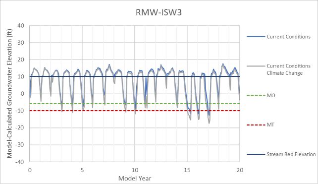
Draft – For discussion purposes only

         GDE VERIFICATION STUDY(3 OF 4)
         Anticipated Schedule

        Desk-top pre-field assessment (November - December 2020).
        On-site and remote field evaluation (February 20-28, 2021).
        ¡ Verify map descriptions or update inaccurate map areas accordingly
        ¡ Document vegetation/wetland community vigor, density, diversity, and sustainability (e.g., natural
          reproduction)
        ¡ Decide whether feature appears to be a GDE and whether it might be sensitive to regional groundwater
          and/or drought conditions

        Remote sensing data evaluation in areas targeted by field work (March 2021).
        ¡ Potential GDEs not identified by NCCAG dataset
        ¡ Seasonal analysis using higher spatial resolution data than used by the GDE pulse tool

        Final TM expected March 31, 2021.

                                                                                                                 6
Draft – For discussion purposes only
GDE VERIFICATION STUDY(4 OF 4)
SWAG feed-back and recommendations for study
implementation
¡ Areas/sites for field surveys?
- Accessible areas for detailed on-site assessment
- Low-access areas for remote assessment
¡ Specific communities or vegetation types for focus?
¡ Metrics and/or datasets to consider to assess GDEs
- Occurrence
- Health
- Trends
¡ Sites/areas for future monitoring and monitoring approaches
7Draft – For discussion purposes only
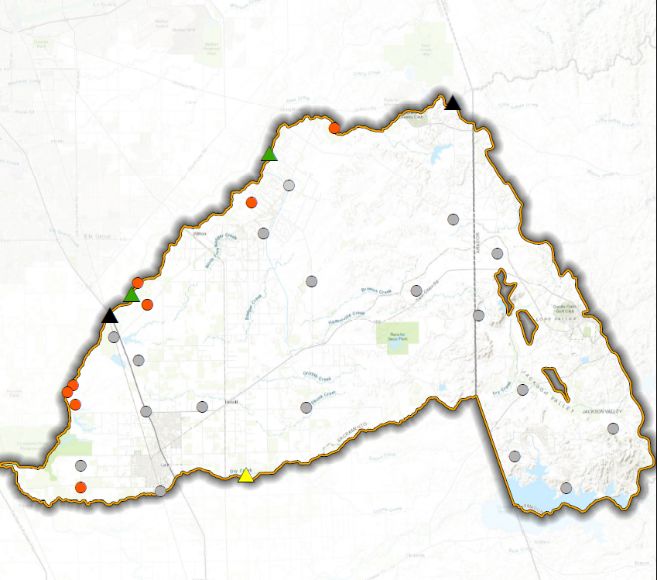
SI: DEPLETION OF ISW (1 of 10)
ISW Monitoring Network
RMW-ISW
RMW-WL
¡ 8 RMW-ISW wells. Planned Prop 68 well
e d?
Planned TSS well
e ct
¡ Four active gaging stations (two RMG
onn
c
dis
Prop 68 RMG
recently installed as part of Prop Inactive RMG
l–
n a
68 Grant) and recommended re- si ti o
n
activation of inactive station. tra
¡ Plans to construct additional wells
to fill ISW data gaps.
– 3 Prop 68 wells connected?
– 1 TSS well site
8Draft – For discussion purposes only
SI: DEPLETION OF ISW (2 of 10)
Key comments considered from SWAG Meeting #2
q Baseline (and MOs) that ensures sustainability (average 2005-2015 or longer)
– Lagged response to altered groundwater conditions
– Consider the variability in groundwater requirements for various components of GDE community (e.g.,
water levels within reach of root systems)
– Magnitude and rate of water level decline
Earliest measured data available begins in 2012 and is insufficient to calculate 2005-2015 average.
q Uncertainty regarding Disconnected vs. Interconnected vs. Transitional reaches
of the Cosumnes River
q Potential climate change effects
9Draft – For discussion purposes only
SI: DEPLETION OF ISW (3 of 10) disconnected
Proposed Approach for SMCs Stream bed elevation
¡ Disconnected
¡ Transitional
¡ Interconnected transitional and interconnected
Stream bed elevation
10Draft – For discussion purposes only
SI: DEPLETION OF ISW (4 of 10)
Proposed approach employs water levels as proxy
¡ Interconnected and transitional reaches
- MO = the range in seasonal-low shallow elevations
over the period of record through 2015 set above
the MT
- MT = highest seasonal low elevation during below-
average rainfall years from the start of monitoring
through 2015
¡ Disconnected reach
- Same approach as Chronic Lowering of
Groundwater Levels
11Draft – For discussion purposes only
SI: DEPLETION OF ISW (5 of 10) RMW-ISW3
SMCs and Projected Water Levels-
Interconnected and Transitional Reaches
Current Conditions
Current Conditions
w/ Climate Change
MO MO
MT MT
Stream Bed Elevation
Preliminary Draft – Subject to Revisions
12Draft – For discussion purposes only
SI: DEPLETION OF ISW (6 of 10) RMW-ISW5
SMCs and Projected Water Levels-
Disconnected Reach
Current Conditions
Current Conditions
w/ Climate Change
MO
MT
Stream Bed Elevation MO
Synthetic Groundwater Elevation MT Stream Bed Elevation
Preliminary Draft – Subject to Revisions
13Draft – For discussion purposes only
SI: DEPLETION OF ISW (7 OF 10)
SGMA defined Sustainability Indicator is a rate or volume (or
via a proxy).
§ 354.28.(c)(6) Minimum Thresholds: Depletions of Interconnected Surface
Water. The minimum threshold for depletions of interconnected surface water shall
be the rate or volume of surface water depletions caused by groundwater use that has
adverse impacts on beneficial uses of the surface water and may lead to undesirable
results. The minimum threshold established for depletions of interconnected surface
water shall be supported by the following:
(A) The location, quantity, and timing of depletions of interconnected surface water.
(B) A description of the groundwater and surface water model used to quantify
surface water depletion.
14Draft – For discussion purposes only
SI: DEPLETION OF ISW (8 of 10)
Evaluate RMWs Data and CoSANA-Calculated Depletions
Measured at gauge or simulated by model
? ?
Modified from LWA, SASb
Working Group,
10/16/2020.
Measured in monitoring wells
GSP Regulations allow GSAs to use groundwater elevation as a proxy metric for any of the
sustainability indicators, provided the GSP demonstrates that there is a significant
correlation between groundwater levels (measured) and depletions (measured or modeled).
15Draft – For discussion purposes only
SI: DEPLETION OF ISW (9 of 10)
SWAG Input on Undesirable Results
SGMA definition: § 354.26.(a) Undesirable Results. Each Agency shall describe in its Plan the processes and
criteria relied upon to define undesirable results applicable to the basin. Undesirable results occur when significant
and unreasonable effects for any of the sustainability indicators are caused by groundwater conditions occurring
throughout the basin.
Comments from SWAG. Undesirable Results could include:
¡ Insufficient water supply for agricultural, residential, and municipal use.
¡ Inadequate flow conditions to allow salmon migration for spawning.
¡ Inadequate outgoing flow conditions for juvenile salmon migration.
¡ Riparian corridor groundwater levels that fail to support existing GDEs from highway 16 to highway 99.
¡ Groundwater levels that fail to support riparian forest and associated GDEs from highway 99 to highway 5.
16Draft – For discussion purposes only
SI: DEPLETION OF ISW (10 of 10)
SGMA Monitoring Network
¡ URs will have to be defined based on the
planned monitoring network
¡ Uncertainty exists regarding whether there is a
relationship between groundwater levels in the
principal aquifer and:
¡ The timing and magnitude of Cosumnes
flows to support migration and spawning
¡ Support for GDEs and riparian forest west
of 99
¡ What information / examples might the SWAG
have to establish quantitative metrics and/or
these relationships
17Draft – For discussion purposes only
BASIN WATER BUDGET
¡ Employed COSANA to preliminarily estimate historical and baseline
projected water budgets
¡ Preliminary results include projected conditions under current land use
conditions in the Cosumnes Subbasin only with and without climate
change
¡ Results provided for example only as a starting point for initial planning
purposes – results will change
¡ Final model results anticipated Spring 2021
18Draft – For discussion purposes only
HISTORICAL STORAGE CHANGE (1999-2018)
12,400 AFY Average Decline in Groundwater Storage.
Plains Foothills
50,000 50,000
Cumulative Storage Change (acre-feet)
Cumulative Storage Change (acre-feet)
0 0
-50,000 -50,000
-100,000 -100,000 -2,300 AFY
-150,000 -150,000
-200,000 -200,000
-10,100 AFY
-250,000 -250,000
-300,000 -300,000
1998
2000
2002
2004
2006
2008
2010
2012
2014
2016
2018
1998
2000
2002
2004
2006
2008
2010
2012
2014
2016
2018 Year
Year
Preliminary Draft – Subject to Revisions
19Draft – For discussion purposes only
HISTORICAL AND PROJECTED WATER BUDGETS
Basin Plain
BASIN PLAIN
20-year average (AFY)
– Projected storage decline
Projected
(2,700 AFY) is less than Budget Term (net) Historical w/o climate w/ climate
Historical storage decline change change
(10,100 AFY) Deep Percolation 66,200 65,400 64,900
River and Creeks 36,600 36,200 37,500
– Climate change will South American -8,800 -5,200 -5,800
exacerbate projected Eastern San Joaquin 4,700 4,900 5,400
annual storage decline Foothills 20,700 21,100 21,400
(increases from 2,700 AFY Wells -129,500 -125,100 -133,400
Change in Storage -10,100 -2,700 -10,000
to 10,000 AFY)
Preliminary Draft – Subject to Revisions
20Draft – For discussion purposes only
BASIN PLAIN WB’s SENSITIVITY TO AG ACREAGE
20-year Average Considering Climate Change.
BASIN PLAIN ONLY
20-year average (AFY)
In this example: Projected w/o climate change Projected w/ climate change
Budget Term (net)
Every 2 AF Baseline
Ag. Acreage
Baseline
Ag. Acreage
Reduced 5% Reduced 20%
decrease in Deep Percolation 65,400 64,800 64,900 62,400
pumping River and Creeks 36,200 36,000 37,500 36,600
corrected about
South American -5,200 -6,000 -5,800 -9,000
1 AF of chronic
Eastern San Joaquin 4,900 3,800 5,400 800
decline in
Foothills 21,100 21,000 21,400 20,800
storage.
Wells -125,100 -119,800 -133,400 -110,300
Change in Storage -2,700 -200 -10,000 1,300
Preliminary Draft – Subject to Revisions 21Draft – For discussion purposes only
ANTICIPATED NEXT STEPS
¡ Technical Efforts (Winter/ Spring 2021)
¡ Finalize modeling and Water Budgets
¡ Incorporate Projects & Management Actions
¡ Complete Prop 68 funded field work
¡ Finalize Sustainability Criteria
¡ Coordination & Outreach (Winter/ Spring 2021)
¡ SWAG Meeting #4
¡ Continue coordination with CoSANA & South American Subbasin
¡ Stakeholder Workshops planned for early 2021
¡ Begin drafting GSP – anticipated draft Summer 2021
22You can also read