Erskine / Chimney Fire Assessment, Inventory and Mapping - By Jennifer Buck-Diaz, Molly S. Wiebush, Kelsey Guest, and Raphaela Floreani Buzbee
←
→
Page content transcription
If your browser does not render page correctly, please read the page content below
Erskine / Chimney Fire Assessment,
        Inventory and Mapping

                          By

Jennifer Buck-Diaz, Molly S. Wiebush, Kelsey Guest,
           and Raphaela Floreani Buzbee
  California Native Plant Society, Vegetation Program
                  2707 K Street, Suite 1
                 Sacramento, CA 95816

                         2021
Abstract

The California Native Plant Society (CNPS) Vegetation Program has produced fine-
scale vegetation maps of woodland habitats for oak (Quercus), pine (Pinus), and juniper
(Juniperus) vegetation types on BLM managed lands before and after the 2016
Chimney and Erskine Fires in the southern Sierra Nevada. Additionally, we collected
and compiled field vegetation data on BLM lands within these two fire perimeters. The
vegetation maps were developed using post-fire ground-based data and a heads-up
digitizing technique using pre-fire (2014) and post-fire (2018) National Agricultural
Imagery Program (NAIP) aerial imagery for Kern and Tulare counties. The minimum
mapping unit (MMU) was 1 acre (0.4 ha) and follows the State of California Vegetation
and Mapping Standards (VegCAMP 2020).

For the Erskine Fire area on BLM managed lands, we documented more than 5,300
acres of woodland habitat in the pre-fire setting, and a reduction in acreage of over
3,300 acres (64%) across all upland woodlands post-fire. The reduction in acreage from
pre- to post-fire was not evenly distributed across all habitat types. For example, the
acreage of Jeffrey pine (Pinus jeffreyi), though not widespread in the region, was
reduced by 98% while the acreage of California juniper (Juniperus californica), which
was much more extensive, was reduced by 72%. For acreage of oak types, blue oak
(Quercus douglasii) and canyon live oak (Q. chrysolepis) each were reduced by 51%,
with the resilient interior live oak (Q. wislizeni) woodlands measured at a 20% reduction.
For the Chimney Fire area, we found a decrease in 1,186 acres of mature pinyon (P.
monophylla) woodlands (98% decrease), and a small increase of 23 acres of
regenerating canyon and interior live oak woodlands in localized spots that were
previously pinyon woodlands. While the primary map attribute is vegetation type,
additional map attributes included structural information (e.g., herbaceous, shrub and
tree cover), tree mortality, site quality and disturbance information.

We also summarized post-fire field sampling efforts in this region with information about
the density of regenerating woody species including oaks, Joshua tree (Yucca
brevifolia), and non-native plant species detected in field surveys. The fine-scale
vegetation maps and supporting survey data provide baseline information for
understanding fire recovery and type conversion of pine, juniper, and oak woodland
habitats in southeastern California. This information will assist in long-term stewardship
and wildlife protection in this unique area, which is a mixing zone between California’s
Mediterranean and Mojave–Great Basin desert vegetation types.

                                                                                             i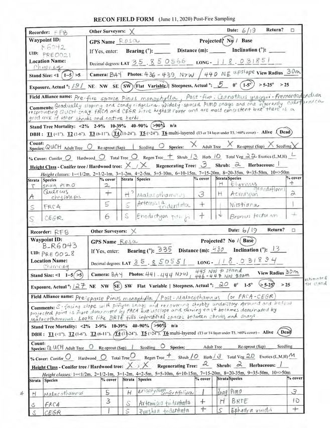
Acknowledgments

This project was accomplished with the assistance of many people:

California Native Plant Society:
       Vegetation Program: Nora Bales, Julie Evens, Betsy Harbert, Adam Hoeft, Alexis
       LaFever-Jackson, Sydney Magner, Steven Serkanic, Kendra Sikes, and Sophia
       Winitsky

We expressly thank the following public land managers and resource experts for
permitting and facilitating our field data collection visits and for overall project
assistance:

US Bureau of Land Management,
  Bakersfield Field Office:
  Sarah Bullock, Jonathan Carvella, Clara Chase, Karen Doran, Amy Girado, Jaymee
  Hasty, Denis Kearns, Timothy Keldsen, Emily Presley, Ismael Ramirez, and Carly
  Summers

   Ridgecrest Field Office:
   Ryan Klausch, Priscilla Watson-Wynn

   Statewide Assessment, Inventory, and Monitoring Program:
   Andrew Johnson

Kern River Preserve, National Audubon Society:
   Reed Tollefson

This project was carried out on the traditional lands of the Kawaiisu Tribe and
Tubatulabal Tribe, and they are bordered by the traditional lands of the Western
Shoshone Tribe. The Kawaiisu and Tubatulabal Tribes are still working for official
federal recognition. These lands were managed by Native Americans before European
settlement, and their use of fire and other land management techniques helped shape
the communities we studied for this project. Further efforts could be taken to involve
local tribes on their traditional ecological knowledge and management of this region.

                                                                                         ii
Table of Contents

Abstract................................................................................................................ i
Figures ............................................................................................................... iv
Tables ................................................................................................................. iv
Introduction and Background ........................................................................... 1
Methods .............................................................................................................. 3
     Vegetation Data Collection ............................................................................. 3
     Vegetation Mapping ....................................................................................... 5

Results ................................................................................................................ 6
     Vegetation Data Collection ............................................................................. 6
     Non-Native Species...................................................................................... 11
     Vegetation mapping ..................................................................................... 12
     Erskine Fire .................................................................................................. 12
     Chimney Fire ................................................................................................ 16
     Map Field Verification ................................................................................... 20

Discussion ........................................................................................................ 21
     Vegetation Types ......................................................................................... 21
     Vegetation Mapping ..................................................................................... 22
     Invasive species ........................................................................................... 22
     Regeneration ................................................................................................ 23
     Wildlife habitat .............................................................................................. 24
     Next steps .................................................................................................... 25

References ........................................................................................................ 26
Appendix A Protocols ...................................................................................... 1
 CDFW-CNPS Protocol for the Combined Vegetation Rapid Assessment and
 Relevé ............................................................................................................... 1
 Protocol for post-burn recon field form ............................................................ 19
 Supplemental Methods (BLM Bakersfield AIM sampling)................................ 25
Appendix B Vegetation Classification ............................................................ 1
Appendix C Density Count Tables by Species .............................................. 1
 Joshua tree ....................................................................................................... 1
 Blue Oak ........................................................................................................... 2
 Interior Live Oak ................................................................................................ 3
 Canyon Live Oak ............................................................................................... 4
Appendix D Non-Native Plant Taxa................................................................. 1
Appendix E Map Attributes .............................................................................. 1

                                                                                                                         iii
Figures
Figure 1. Overview map of the locations and extent of the Erskine and Chimney
fires. ..................................................................................................................... 2
Figure 2. Erskine fire perimeter with locations of AIM transects, Rapid
Assessments, Relevés, and Reconnaissance surveys conducted from 2018–
2020. .................................................................................................................... 7
Figure 3. Chimney fire perimeter with locations of AIM transects, Rapid
Assessments, Relevés, and Reconnaissance surveys conducted from 2018–
2020. .................................................................................................................... 8
Figure 4. Extensive stands of poodle-dog bush (Eriodictyon parryi) post-fire in
the Erskine fire footprint. ...................................................................................... 9
Figure 5. In this post-fire pinyon pine stand, prickly poppy (Argemone munita), a
common herbaceous fire-follower, is thriving. ...................................................... 9
Figure 6. a.) Resprouting interior live oak (Quercus wislizeni) and b) Joshua tree
(Yucca brevifolia) send up new shoots from underground rhizomes. ................. 10
Figure 7. Comparison of the pre- and post-fire mapped oak woodlands in the
northwestern part of the Erskine Fire. Perimeters of pre-fire polygons are visible
as light orange outlines on the post fire map. ..................................................... 13
Figure 8. Comparison of the tree cover attribute for the pre- and post-fire
mapping of oak woodlands in the northwestern portion of the Erskine Fire.
Perimeters of pre-fire polygons are visible as light orange outlines on the post fire
map. ................................................................................................................... 15
Figure 9. Fine-scale delineation of a pre-fire polygon (in green outline) with its
reduced post-fire polygon (in blue outline) and a depiction of the attribute table
that accompanies each polygon in the map. ...................................................... 16
Figure 10. Comparison of pre- and post-fire mapping for the dominant woodland
types in the Chimney Fire perimeter................................................................... 17
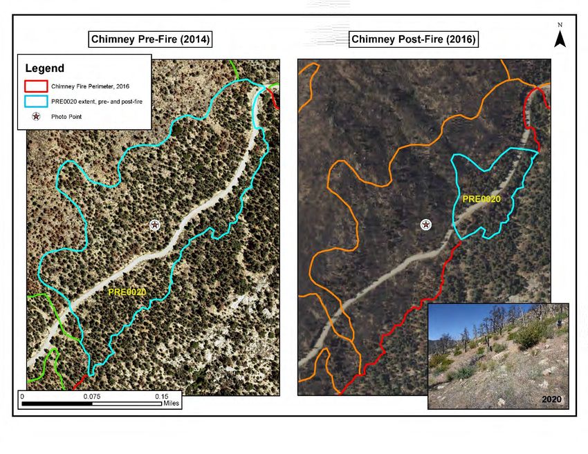
Figure 11. Delineation of a pre-fire polygon on the left (PRE0020) adjacent to the
much reduced post-fire polygon on the right (in blue outline) showing a backdrop
of NAIP imagery before and after the Chimney fire. ........................................... 18
Figure 12. Comparison of tree cover attribute for the pre- and post-fire mapping
of woodlands in the Chimney Fire perimeter. Perimeters of pre-fire polygons are
visible as light orange outlines on the post- fire map. ......................................... 19
Tables
Table 1. A list of WHR Habitat types within each fire perimeter on BLM land.
Highlighted cells were targeted within the 2018-19 CNPS AIM sampling............. 4
Table 2. Summary of vegetation surveys conducted from 2018 to 2020 by CNPS
including their survey method per fire area. ......................................................... 7
Table 3. Pre- and post-fire acreages for woodland vegetation types in the
Chimney and Erskine Fire perimeters. ............................................................... 14
iv
Introduction and Background

In 2018, the US Bureau of Land Management (BLM) contracted with the California
Native Plant Society (CNPS) for the following: 1) establish Assessment, Inventory and
Monitoring (AIM) plots across a spectrum of ecological sites, 2) complete field surveys
in other fine-scale vegetation patterns, and 3) conduct fine-scale mapping of priority
vegetation types both pre- and post-fire in the Erskine and Chimney fire footprints
(Figure 1).

In late June of 2016, the Erskine fire ignited near an archery range at the base of Cook
Peak in Kern County, California. The fire ultimately burned 48,019 acres, of which
11,471 acres fell within the BLM Central California District Bakersfield Field Office (FO),
and 5,906 acres burned in the California Desert District Ridgecrest FO. Broad
vegetation types within the Erskine fire footprint include blue oak–interior live oak,
pinyon pine, gray pine, Jeffrey pine and California juniper woodlands, high desert scrub
with cholla cactus, isolated willow, cottonwood and alder riparian areas, and annual
grasslands (BLM BAER 2016). The Erskine fire intersected with the footprints of at least
32 other fires that have occurred over the last 100 years (CALFIRE-FRAP 2020). The
2016 fire varied in severity throughout its extent and included areas of low and high
severity burn.

In early June 2016, the Chimney fire ignited about 15 miles northeast of Kernville in
Tulare County, and it burned 1,275 acres within BLM Bakersfield FO lands. The
Chimney fire’s cause is unknown, burning through mainly pinyon pine and canyon oak
woodlands with high severity. No other fires have occurred within the perimeter of the
Chimney fire in the last 100 years (CALFIRE-FRAP 2020).

These two fire areas are situated at the intersection of the Central Valley, Sierra
Nevada, and Mojave Desert ecoregions. The overlapping ecoregions and variation in
climate and geology make this area floristically unique. An understanding of how
vegetation types respond to disturbance is important for long term resource
management, especially considering interacting threats such as fires and changes in
historic fire regimes, invasive plant species, and global climate change. The data
presented in this report and the accompanying vegetation maps highlight the
importance of monitoring efforts to inform the recovery of key tree species after fire.

BLM Bakersfield Vegetation Mapping Report                                          1

Figure 1. Overview map of the locations and extent of the Erskine and Chimney fires,
and the BLM lands within these fire perimeters. BLM land extends beyond the fire
perimeters but is not shown in this graphic.

BLM Bakersfield Vegetation Mapping Report                                     2
Methods

Vegetation Data Collection

BLM Bakersfield FO and CNPS staff, in coordination with the CA AIM coordinator,
completed an AIM Monitoring Design Worksheet to document project objectives
including a description of the study area, sample design, and steps to ensure data
quality. These objectives included establishing long-term monitoring plots for terrestrial
vegetation to track change over time, measuring regeneration of important woody
species, and tracking invasive species. Vegetation surveys were collected using the
BLM Assessment, Inventory and Monitoring (AIM) method (Herrick et al 2005). A
supplemental AIM protocol was used to measure the density of target woody species
within plots including oaks (Quercus spp.) and Joshua tree (Yucca brevifolia), see
Appendix A. Density is one of the best measures for initial recovery of target species
post-fire. CNPS documented how many adults of each species survived and counted
emergent sprouts and/or seedlings. In addition to these objectives, CNPS sought to
sample and key out fine-scale vegetation patterns to the Alliance and Association level
following the classification system used throughout California for vegetation assessment
(CNPS 2020).

AIM plot placement was based on a sample allocation to capture upland habitat types
that occur broadly in the region. Locations within the Erskine fire area were assigned
using the SHINY package for R, a tool that generates a spatially balanced, stratified
random point allocation. The tool used the Erskine fire perimeter, BLM land ownership,
and existing Wildlife Habitat Relationship (WHR) types as stratification inputs. WHR was
used because detailed Ecological Site Descriptions (ESD’s), which are typically used to
allocate AIM plots, have not been defined for much of California’s vegetation. More
information about WHR and the existing CalVeg mapping is available online (CALVEG
2010). Table 1 includes a list of WHR types found within the two fire footprints.

Twelve habitats in the Erskine area were merged into seven categories by combining
similar types (e.g. Pinyon-Juniper with Juniper) and the categories were used for the
allocation stratification (Table 1). The allocation consisted of three Base points and
seven Oversample points for each habitat type for a total of 70 allocated points. An
additional three points in the Erskine area were targeted, or subjectively placed, to
capture small habitat patterns such as Valley Oak, Blue Oak and Joshua tree
woodlands. Five plot locations in the Chimney fire were targeted across three habitat
types (Table 1).

BLM Bakersfield Vegetation Mapping Report                                         3
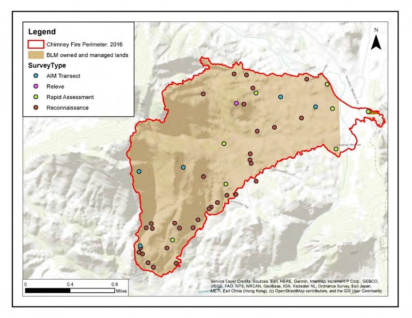
Table 1. A list of WHR Habitat types within each fire perimeter on BLM land. Highlighted
cells were targeted within the 2018-19 CNPS AIM sampling.

 ERSKINE Fire Area
 WHR Name                   Sum Acres
 Annual Grassland              3,850
 Blue Oak-Foothill Pine         354
 Blue Oak Woodland               47
 Desert Scrub                  3,877
 Desert Wash                     21
 Joshua Tree                     4
 Mixed Chaparral               5,621
 Montane Hardwood-Conifer       102
 Montane Hardwood               185
 Montane Riparian                18
 Juniper                        199
 Pinyon-Juniper                1,658
 Lacustrine
After the allocation, all sample points were reviewed in the office using ancillary GIS
data such as digital elevation models (DEMs) to assess suitable slopes. CNPS and
BLM staff followed established AIM rejection criteria to screen all allocated points.
Almost half of the allocated points (32) were rejected due to a slope of greater than
50%, and these rejections occurred across all mapped habitat types. In the field, the
AIM plot center points were monumented with 10-inch nails and large washers for ease
of relocation using a metal detector. AIM field surveys were conducted by CNPS staff in
2018 and 2019. After data collection, CNPS staff entered and conducted quality control
on AIM data into the standard Database for Inventory, Monitoring and Assessment
(DIMA) and submitted it to the CA AIM coordinator.

Vegetation surveys were also collected using the CNPS/CDFW Combined
Vegetation Rapid Assessment and Relevé protocol (Appendix A). The sample
allocation for this effort was stratified using CalVeg (Classification and Assessment
with Landsat of Visible Ecological Groupings) and FVEG mapping within both fire
footprints (CALVEG 2010, Calfire-FRAP 2015). This method, which was significantly
quicker than AIM surveys by employing ocular cover estimates as the primary metric
to quantify the importance/ abundance of a species or strata for vegetation
classification, allowed for the documentation of a finer-scale diversity of vegetation
types, especially those not captured by AIM plots, including riparian and desert wash
habitats. CNPS staff completed these surveys in 2018, 2019 and 2020.

Additionally, Reconnaissance surveys, consisting of GPS location and notes on
vegetation type and species cover, were collected to ground-truth draft map polygons in
2020. CNPS staff used reconnaissance data sheets that included fields for tree mortality
and counts for regeneration of woody species (Appendix A). We prioritized
reconnaissance surveys in map areas thought to support oak and conifer habitats
through a review of aerial imagery and the existing CalVeg map attributes.

Vegetation Mapping

Pre-fire and post-fire vegetation maps were completed through heads-up digitization,
following CDFW guidelines and state standards (VegCAMP 2020). Vegetation polygons
were digitized using ESRI’s ArcMap (version 10.5.1) at a scale of approximately
1:2,000. Base imagery for mapping relied on 2014 and 2018 National Agricultural
Imagery Program (NAIP) aerial imagery (1:12,000 spatial accuracy) from Kern and
Tulare Counties (NAIP 2018) displayed as both natural color (RGB) and color infrared
(CIR). Other data aided in digitizing polygons and designating map attributes, including
CalVeg (2010) and FVEG maps (CALFIRE-FRAP 2015). In addition, CNPS used GIS

BLM Bakersfield Vegetation Mapping Report                                        5
layers representing the extent and severity of fire for both the Chimney and Erskine fires
(CALFIRE-FRAP 2020).

For the mapping effort, the vegetation classification and field key for the Sierra Nevada
Foothills (VegCAMP, in progress) was used to identify and map vegetation types of
interest. Prioritized vegetation types were mapped at the Alliance level following the
online Manual of California Vegetation (MCV, CNPS 2020). Mapping rules were
implemented to prevent ‘over-delineating’ or splitting vegetation stands into polygons
that lack ecological significance. The following mapping rules were used in this project:
    • Minimum mapping unit (MMU) – the minimum polygon size allowed:
            o 1 acre for upland vegetation types.
            o 10-meter width for linear polygons meeting the MMU.
    • Polygon breaks – the minimum polygon size allowed in splitting a vegetation type
        into multiple polygons:
            o 3 acres when splitting by cover in the overstory
            o 5 acres for splitting by cover in the understory
            o 5 acres for non-floristic differences of at least two classes (e.g.,
               development, roads/trails, etc.)

Using the survey data available, aerial photo signatures (color-texture-tone
combinations) for each priority vegetation type were reviewed across both pre- and
post-fire imagery. We mapped tree-dominated vegetation in pre- and post-fire including
woodlands and open savanna-like areas of >5% tree cover (lower than the typical 10%
threshold, because fire and other impacts have reduced tree cover in the area) but did
not map areas where trees were scattered at less than 5% cover. Correlations between
the vegetation units and photo signatures were evaluated and refined to ensure that the
map consistently represented vegetation types of interest at a fine-scale resolution.
After initially mapping portions of the study area, two field reconnaissance trips were
conducted in June and August of 2020 to verify signatures for post-fire mapping. Pre-
fire polygon attributes (Appendix E) were informed by the imagery and on-the-ground
reconnaissance of standing dead tree cover and adjacent intact areas.

                                            Results

Vegetation Data Collection

CNPS staff established 40 permanently marked BLM Assessment, Inventory and
Monitoring (AIM) plots and completed 70 Rapid Assessments, 3 Relevés, and 95
Reconnaissance surveys in the Erskine (Figure 2) and Chimney (Figure 3) fire footprints

BLM Bakersfield Vegetation Mapping Report                                         6
to document post-fire vegetation types (Table 2). Each survey was classified to the
alliance level using the statewide MCV and the National Vegetation Classification
System (NVCS), see Appendix B which denotes 42 alliances and includes survey
counts per alliance. This level of classification is useful for describing plant communities
based on dominant or diagnostic species of the uppermost or dominate stratum.
Table 2. Summary of vegetation surveys conducted from 2018 to 2020 by CNPS
including their survey method per fire area.
Erskine Chimney
Method AIM RA Relevé Recon AIM RA Relevé Recon Total
2020 0 23 0 63 0 0 0 22 108
2019 8 36 1 5 2 8 1 2 63
2018 27 3 1 7 3 0 0 1 42
Total 35 62 2 75 5 8 1 25 213
Figure 2. Erskine fire perimeter with locations of AIM transects, Rapid Assessments,
Relevés, and Reconnaissance surveys conducted from 2018–2020.
BLM Bakersfield Vegetation Mapping Report 7Figure 3. Chimney fire perimeter with locations of AIM transects, Rapid Assessments, Relevés, and Reconnaissance surveys conducted from 2018–2020. In the field, two AIM points from the Erskine fire were either rejected or only partially sampled due to safely concerns from dense cover of the fire-following poodle-dog bush (Eriodictyon parryi), which can cause severe dermatitis (Figure 4). Other fire-following herbs were noted in abundance such as prickly poppy (Argemone munita, see Figure 5), ear drops (Ehrendorferia chrysantha), and whispering bells (Emmenanthe penduliflora), as well as fire-following shrubs such as California flannelbush (Fremontodendron californicum) and Fremont’s bushmallow (Malacothamnus fremontii). BLM Bakersfield Vegetation Mapping Report 8
Figure 4. Extensive stands of poodle-dog bush (Eriodictyon parryi) post-fire in the
Erskine fire footprint.

Figure 5. In this post-fire pinyon pine stand, prickly poppy (Argemone munita), a
common herbaceous fire-follower, is thriving. The Chimney fire burned in steep terrain
and most woody species were heavily damaged.

BLM Bakersfield Vegetation Mapping Report                                        9
CNPS used a supplemental AIM protocol (Appendix A) to measure the density of target
woody species including re-sprouting oaks (Quercus spp.) and Joshua trees (Yucca
brevifolia). We noted regeneration of these groups in both the Erskine and Chimney fire
footprints (Figure 6).

a)                                          b)

Figure 6. a.) Resprouting interior live oak (Quercus wislizeni) and b) Joshua tree
(Yucca brevifolia) with new shoots from underground rhizomes.

We identified regenerating Joshua tree in 11 AIM plots with density counts of resprouts
ranging from 7 – 87 individuals per plot, with a total of more than 400 resprouts.
However, very few adult Joshua trees survived post-fire with only three adults tallied
across two of the 11 surveys (Appendix C). We also identified Joshua tree in 14 Rapid
Assessments with live absolute cover of adult trees ranging from 0.2 – 7%, resprouts
were present in at least 85% of these surveys, though with low cover.

We assessed density of blue oaks in two AIM plots, three Rapid Assessments and 14
Reconnaissance surveys; 37% of these surveys had seedlings present, 68% had
saplings, and 79% had live adults remaining with an average of six adult trees within the
assessed areas (~30m radius), see Appendix C. We also assessed density of interior
live oaks in four AIM plots, one Rapid Assessment and 17 Reconnaissance surveys;
only 14% of these plots had seedlings, while 90% had saplings, and 60% of plots had
live adults across variable plot sizes (Appendix C). Finally, we assessed density of
canyon live oaks in one AIM plot, one Rapid Assessment and 14 Reconnaissance
Surveys; only 6% of plots had seedlings, while 88% had saplings, and 36% had live
adults (Table 6). As expected, live oaks are generally considered to be fire tolerant and
had better success in re-sprouting (saplings) after fire as compared with blue oak
(CNPS 2020, Fryer 2012).

BLM Bakersfield Vegetation Mapping Report                                       10
The surveys were also used to document the presence of non-native species and to
assist in the delineation and attribution of pre- and post-fire vegetation mapping of tree-
dominated types in the Chimney and Erskine fire perimeters.

Non-Native Species

Across 213 surveys, 34 non-native taxa were detected (Appendix D). In approximately
70% of the sites sampled (152 out of 213), we noted cheatgrass (Bromus tectorum), a
BLM priority weed that is also ranked High by the California Invasive Plant Council (Cal-
IPC 2020) – see Appendix D for Cal-IPC rank definitions. The estimated cover of
cheatgrass ranged from less than 1% to 25% with a mean cover of 6% across surveys.
Cheatgrass flowers in the early spring and the florets disperse short distances with wind
and rodent activity or to greater distances by clinging to the fur, feathers, and feet of
animals. Seeds typically survive in soil for 2-3 years and thatch accumulation or shallow
burial favors establishment of germinating seeds. Burning usually results in an increase
in cover of cheatgrass especially in semi-arid areas (DiTomaso et al 2013).

The other priority BLM weed detected was Saharan mustard (Brassica tournefortii),
though this species was detected in only one survey along Cook Peak Road at less
than 1% cover. Like many mustard species, Saharan mustard can develop a large,
persistent seedbank with extremely long seed viability (DiTomaso et al 2013). Control
measures for mustards are most effective when the population size is small. Pulling or
hoeing has proven effective for removing mustard populations, though this technique
should be implemented while the ground is soft and before the seeds mature. Fire has
been shown to increase mustard populations.

Other priority weed species of concern as defined in the BLM BAER report were not
detected within our vegetation surveys in the fire perimeters including perennial
pepperweed (Lepidium latifolium), bull thistle (Cirsium arvense), yellow star thistle
(Centaurea solstitialis), and Tamarisk (Tamarix sp.).

Additional non-native species of High or Moderate rank by Cal-IPC were detected
including red brome (Bromus rubens). Along with cheatgrass, the presence of red
brome often promotes more frequent fires within habitats, which in turn opens more
habitat for the species to further colonize sites. Fire has been successful at reducing red
brome populations, though only in early spring before the seeds have set. Most wildland
fires, such as the Erskine and Chimney fires, ignite later in the year. Late-season fires
are ineffective at reducing seed bank populations of these non-native grasses. The
effect of control methods on native plant populations and diversity is an important

BLM Bakersfield Vegetation Mapping Report                                         11
consideration before implementing any management strategies against red brome.
Many sites within the fire perimeters maintain high native plant species diversity and/or
abundance regardless of the presence of red brome, so any control methods should
avoid disturbance to established native plant populations.

In addition, one tree of heaven (Ailanthus altissima) individual was found along Cook
Peak Road at UTM-E 370935, UTM-N 3942169. Tree of heaven can spread and form
dense thickets that compete with native vegetation and reduce wildlife habitat,
particularly in riparian areas (DiTomaso et al. 2013). Removal should be prioritized to
control the spread of this moderately ranked non-native species.

Non-native species were detected at varying levels within different plant communities
(Appendix D); the blue oak alliance (Quercus douglasii) had the highest absolute cover
of non-native species (mean 65%) and richness of non-native plants (14 taxa). Only one
non-native species (Bromus tectorum) was detected within the Jeffrey pine alliance.
Tree willow riparian stands (Salix gooddingii – Salix laevigata) had the lowest cover of
non-native species at 1% with only one species noted (Festuca perenne) though it
should be noted that the shorter reconnaissance and rapid assessment surveys do not
contain a comprehensive species list, thus may not have recorded all non-native
species present.

Vegetation mapping

Erskine Fire

The Erskine fire burned through a variety of habitat types which have persisted through
an active fire history; at least 32 previous fires were recorded within the 2016 fire
footprint in the last 100 years (CALFIRE-FRAP 2020). In the Erskine region, we focused
on mapping both conifer and oak woodlands including blue oak, canyon oak and interior
live oak. Oak woodlands are of particular interest because research shows that survival
and response to fire is variable across different species and can depend on site specific
characteristics such as soils and fire intensity. In general, blue oak can resprout after
fire, but it has thin bark and may be relatively sensitive to fire compared to other oak
species (CNPS 2020, Fryer 2012). Some studies suggest a link between fire and
seedling/ sapling release (e.g. Mensing 1992) and other studies find no benefit to
recruitment and growth from fire (Bartolome et al. 2002, Swiecki and Bernhardt 2002,
Arevalo 2009). Both canyon and interior oaks tend to have rapid regeneration after fire
(CNPS 2020, Fryer 2012, Tollefson 2008), and we expected the extent of live oaks to
be less affected by fire than blue oak.

BLM Bakersfield Vegetation Mapping Report                                        12
The 2016 fire had a varying intensity across the region. Blue oak and canyon oak
woodlands were both reduced to half (51%) of their pre-fire extent, a decrease of 166
and 576 acres, respectively. Interior live oak was less affected by fire with a decrease of
20% of pre-fire acres (Table 3). Blue oak and interior live oak stands are mainly
restricted to the rolling hills of Cook Peak east of the town of Lake Isabella in the far
western portion of the fire footprint (near the fire origin) (Figure 7). Canyon live oak
dominates in higher elevations of the Piute Mountains within the fire footprint and most
of the pre-fire acreage falls to the east within the BLM Ridgecrest FO. At lower
elevations, canyon live oak occupies more mesic settings which buffered the quick-
moving fire and burned at low intensities.

Figure 7. Comparison of the pre- and post-fire mapped oak woodlands in the
northwestern part of the Erskine Fire. Perimeters of pre-fire polygons are visible as light
orange outlines on the post-fire map.

BLM Bakersfield Vegetation Mapping Report                                         13
Table 3. Pre- and post-fire acreages for woodland vegetation types in the Chimney and
Erskine Fire perimeters.

                                      ERSKINE Fire                 CHIMNEY Fire
                           Pre-Fire    Post-Fire Acreage Pre-Fire Post-Fire Acreage
 Vegetation Alliance
                           Acreage     Acreage     Change Acreage Acreage Change
 Juniperus californica        1802          482      -1320       0         0       0
 Quercus douglasii              328         162       -166       0         0       0
 Quercus wislizeni              492         393        -99       6         5      -1
 Quercus chrysolepis           1129          553    -576          2         26
                                                                                     +24
 Pinus jeffreyi                  88            2     -86         0           0         0
 Pinus monophylla              1035          132    -903      1214          28     -1186
 Pinus sabiniana                430          203    -227         0           0         0

 Total Acreage                 5304         1927   -3377      1222          59     -1163

Conifer types including gray pine (Pinus sabiniana), Jeffrey pine, pinyon pine, and
California juniper were also mapped in this region, and all were strongly impacted by the
2016 fire. Gray pine is fire sensitive despite the relatively thick bark on mature
individuals (CNPS 2020). Stands have tolerated a history of low-intensity fires with
grassy, open understories, or on rocky sites. The distribution of gray pine in the Erskine
fire footprint is similar to that of blue oak and interior live oak, sparsely dominating open
slopes around Cook Peak and other hills south of Lake Isabella. Gray pine habitat was
reduced by about 50% of its pre-fire extent, a decrease of 227 acres (Table 3).

Jeffrey pine stands are moderately resistant to fire, though response varies according to
fire intensity, tree age, and the surrounding vegetation (CNPS 2020). Stands within the
Erskine fire footprint occur along north-east facing slopes of the Piute Mountains above
Kelso Valley. Only one small stand remains post-fire with an overall decrease of 86
acres or 98% of pre-fire Jeffery pine woodlands (Table 3). This vegetation type was not
depicted in CalVeg maps for this area.

California juniper was widespread across the area pre-fire, but only 27% of this
woodland remains post-fire with a decrease of 1,320 acres (Table 3). California juniper
is an obligate seeder, meaning it does not sprout after fire and is not strongly fire-
adapted in desert settings (CNPS 2020). The dominance of non-native annual grasses
may have contributed to a higher intensity fire in this region. In the Transverse Ranges,
stand recovery from a single fire event may take upwards of 125 years (M. Brooks,
pers. comm. 1999).

BLM Bakersfield Vegetation Mapping Report                                          14
Pinyon pine woodlands are vulnerable to fire at all life stages. Pinyon pine habitat occurs mostly in the Ridgecrest FO at higher elevations along the eastern edge of the Piute Mountains. While some stands may persist after low or moderate intensity fire, pinyon pine habitat decreased 87% (903 acres) after the 2016 fire. While pinyon pine fire response and recovery has been well researched in the Great Basin, less is known about recovery after fire along the edge of its range in southeastern California. In summary, the 2016 Erskine fire reduced two-thirds of the forested acreage, burning over 3,300 acres of woodland and most heavily affecting conifer types including Jeffrey pine, pinyon pine, and California juniper. In addition to reducing the acreage of forested types, the cover of trees within the remaining forest types was reduced (Figure 8), across the Erskine fire area the mean cover of trees dropped from 21% pre-fire to 17% post-fire. Figure 9 illustrates map attributes assessed for each polygon including vegetation type, structural information (e.g., herbaceous, shrub and tree cover), tree mortality, site quality and disturbance characteristics. Figure 8. Comparison of the tree cover attribute for the pre- and post-fire mapping of oak woodlands in the northwestern portion of the Erskine Fire. Perimeters of pre-fire polygons are visible as light orange outlines on the post fire map. BLM Bakersfield Vegetation Mapping Report 15
Figure 9. Fine-scale delineation of a pre-fire polygon (in green outline) with its reduced
post-fire polygon (in blue outline) and a depiction of the attribute table that accompanies
each polygon in the map.

Chimney Fire

In the Chimney fire footprint, CNPS focused on mapping pinyon pine woodlands and
regenerating oak woodlands. Pre-fire, pinyon pine was the dominant vegetation type
within the Chimney fire’s extent. These woodlands appear to have had a mix of sub to
co-dominant oak trees, mainly canyon and interior live oak, especially in ravines and
drainages. Pinyon forests and woodlands are especially vulnerable to fire and thus tend
to establish in areas with infrequent fire (Zouhar 2001). Chimney Peak has no record of
wildfire activity in the last 100 years (CALFIRE-FRAP 2020).

CNPS estimates that there were 1,214 acres of pinyon pine woodlands within the
perimeter of the Chimney Fire before it burned (Figure 10). Post-burn, only 28 acres of
these woodlands survived at the edges of the fire perimeter and occasionally in areas
protected by rock outcroppings, a 98% decrease (Figure 11 and Table 3). In contrast,

BLM Bakersfield Vegetation Mapping Report                                         16
the area of oak woodlands increased post-fire, expanding from 8 to 31 acres, though
tree cover is much reduced from pre-fire levels (Figure 12). Both canyon live oak and
interior live oak resprout after fire, unlike pinyon pine, which cannot resprout and must
be reseeded into burned areas by birds and mammals (Fryer 2012, Tollefson 2008). It is
estimated to take 100 to 300+ years for a mature pinyon woodland to fully establish
post-fire (Zouhar 2001).

Figure 10. Comparison of pre- and post-fire mapping for the dominant woodland types
in the Chimney Fire perimeter.

BLM Bakersfield Vegetation Mapping Report                                       17
Figure 11. Delineation of a pre-fire polygon on the left (PRE0020) adjacent to the much
reduced post-fire polygon on the right (in blue outline) showing a backdrop of NAIP
imagery before and after the Chimney fire.

BLM Bakersfield Vegetation Mapping Report                                     18
Figure 12. Comparison of tree cover attribute for the pre- and post-fire mapping of
woodlands in the Chimney Fire perimeter. Perimeters of pre-fire polygons are visible as
light orange outlines on the post- fire map.

BLM Bakersfield Vegetation Mapping Report                                      19
Post-fire surveys reveal successional shrub types replacing the pinyon pine forest
including cup leaf ceanothus - California flannelbush chaparral (Ceanothus greggii –
Fremontodendron californicum alliance) and bush mallow scrub (Malacothamnus
fremontii provisional association) as well as herbaceous types such as grape lupine -
blazing star - annual buckwheat fields (Lupinus excubitus – Mentzelia albicaulis –
Eriogonum spp. association). It seems likely that the extent of shrub and oak woodland
stands will continue to expand in the Chimney fire perimeter, where canyon live oak is
more abundant in drainages and at higher elevations than interior live oak.

Map Field Verification

Two reconnaissance trips were conducted after drafts of the pre- and post-fire maps
were delineated. Polygons attributed by photo interpretation were selected to ground-
truth tree species identification and percent cover of various strata. Estimates of
standing dead cover as well as observation of nearby unburned areas were used to
help inform pre-fire map attributes (Appendix E). A third reconnaissance trip was
planned for August 2021, however, this trip was canceled due to the 2021 French Fire
and poor air quality in the region. The lack of post-mapping field verification decreases
our confidence in the accuracy of delineated polygons and their attributes especially in
the mapping of conifer types in south-eastern Erskine region. However, both pre- and
post-fire oak woodland maps were verified and revised using reconnaissance data from
June and August 2020.

BLM Bakersfield Vegetation Mapping Report                                       20
Discussion

As fire frequency and intensity increase across California, BLM has invested in
monitoring and mapping priority habitats including oak woodlands, areas with Joshua
tree, and conifer woodlands and forests. The fine-scale vegetation maps of pre- and
post-fire in these habitats on BLM lands within the Erskine and Chimney fire footprints
and supporting survey data within this report and in the accompanying geodatabase
provide baseline information for understanding fire recovery and type conversion of
pine, juniper, and oak woodland habitats in southeastern California.

Vegetation Types

Ecological Site Descriptions (ESD’s) are reports generated through the USDA Natural
Resources Conservation Service (NRCS) that provide detailed information to classify
and describe soils and vegetation. Unfortunately, detailed ESD’s have not been
developed for much of California’s vegetation. However, the US National Vegetation
System USNVC (FGDC 2008, USNVC 2019) and the statewide Manual of California
Vegetation (MCV, CNPS 2020) contain detailed descriptions of vegetation types for the
state. These resources were used to assess and classify each vegetation survey to the
alliance level (Appendix B) and association level. The burned areas proved to have a
high diversity of vegetation types with more than 40 alliances documented. In addition,
three new provisional associations were documented in the study areas under existing
alliances including: 1) Lupinus benthamii – Chorizanthe membranacea Association in
the Eschscholzia (californica) – Lupinus (nanus) Alliance; 2) Eriodictyon parryi
Association in the Lotus scoparius – Lupinus albifrons – Eriodictyon spp. Alliance, and
Malacothamnus fremontii Association in the Malacothamnus fasciculatus –
Malacothamnus spp. Alliance. These provisional associations and the vegetation survey
data contribute to a better understanding of California vegetation and statewide
mapping efforts.

Existing statewide vegetation maps (CalVeg), developed between 1997 – 2016 for this
region, were used to stratify the landscape to establish AIM plots across a variety of
habitat types and to inform pre- and post-fire fine scale mapping. However, the CalVeg
data layer was found to be spatially and thematically inaccurate, especially when relying
on the map crosswalk with WHR (Wildlife Habitat Relationship). In 17 out of 40 AIM
surveys (42%), the WHR class was incorrect including confusion within Sagebrush and
Montane Hardwood types, among others.

BLM Bakersfield Vegetation Mapping Report                                       21
In general, we found that CalVeg overestimated acreages of Blue Oak and Joshua tree
woodlands and omitted Canyon Live Oak, Interior Live Oak, and Jeffrey Pine types in
the Erskine perimeter. The documentation of these types through field surveys and
alliance-level mapping highlights the importance of ground-truth efforts and fine-scale
mapping of priority areas. One complication in comparing the CalVeg map with alliance-
level mapping is the emphasis by CalVeg on conifer species over hardwoods. For
example, when pinyon pine is mapped by CalVeg, the polygons can include significant
and sometimes dominant cover of canyon live oak, which falls under an oak alliance in
the USNVC. Similarly, when gray pine is mapped by CalVeg, stands often include
significant cover of interior live oak and/or blue oak, which would translate to those
respective oak alliances under the USNVC. In the Chimney perimeter, CalVeg
overestimated acreages of Sagebrush and under-mapped open herbaceous
communities comprised of mixed perennial and annual grasses and forbs.

Vegetation Mapping

Pre-fire mapping was completed using pre-fire aerial imagery but without on-the-ground
pre-fire surveys. While general tree and shrub cover can be estimated from aerial
imagery, species may have been mis-identified (for example junipers and oaks can look
similar in aerial imagery) and it is difficult to estimate cover of the herbaceous layer and
the impact of non-native species from aerial photos alone. One of the difficulties in
mapping oak woodland regeneration in the Erskine region was the low cover of trees,
which tend to occupy open savannas or sparsely wooded habitats (defined as less than
10% tree cover). The mapping of pre- and post-fire woodland extent in this project
includes open savanna-like areas of >5% cover but not scattered oaks at less than 5%
cover. The fire history within the Erskine footprint indicates a short fire return interval for
this region, and fire is strongly implicated in the maintenance of open savanna
vegetation. Monitoring these open oak savannas and woodlands will provide valuable
insight on how fire and other climatic factors (e.g., drought cycles) are affecting the
presence, distribution, and cover of oak species of interest.

Invasive species

Invasive species such as cheatgrass (Bromus tectorum) can increase fire frequency
and fire intensity (Zouhar 2003), especially in arid systems. Increases in fire frequency
caused by invasive species can prevent re-establishment of various oak and pine
species. In parts of southern California (such as the San Gabriel and San Bernardino
mountains), cheatgrass has been implicated in transforming pinyon woodlands to
chaparral (CNPS 2020, Zouhar 2001.) Some studies also suggest that abundant

BLM Bakersfield Vegetation Mapping Report                                             22
invasive species associated with blue oak savannas and woodlands could reduce blue
oak recruitment (Fryer 2007). Vegetation monitoring programs in both burned and
unburned areas could provide useful baseline information for how herbaceous layers
change after fire. An understanding of these dynamics could inform more effective
management and restoration planning.

Regeneration

The post-fire field sampling efforts across the Erskine and Chimney fire footprints
documented regeneration in live oak and Joshua trees. However, limited survival and
little to no regeneration was noted in conifers such as Jeffrey and pinyon pine. These
tree species exhibit different life history strategies. Oaks and Joshua trees have the
ability to resprout from basal storage systems in order to quickly regenerate after fire.
Conifers tend to rely on seed dispersal after fire. Therefore, the survival and persistence
of adjacent mature trees is a critical seed source to ensure conifer replacement after
fire.

Future study in this region could expand beyond the early effects of fire on Joshua tree
woodland regeneration. Joshua trees are found on the eastern edge of the Erskine fire
perimeter and more than 80% of the surveys with Joshua tree (Yucca brevifolia) present
had regenerating sprouts detected. Though they can resprout from underground
rhizomes, they appear to be sensitive to fire and it is likely that this sensitivity varies by
subspecies (CNPS 2020, Gucker 2006). In October 2020, the state of California granted
temporary protection for Joshua trees while it reviews a petition to list this species under
the California Endangered Species Act (CA Fish and Game Commission). Joshua tree
is the first species to achieve candidate status based on threats of climate change.
Tracking response of Joshua tree to fire, especially at the edges of its natural range, will
be integral to statewide recovery efforts.

The Chimney Fire burned through pinyon pine mixed with canyon and interior live oak.
In the Great Basin, where most of the research on pinyon pine regeneration has
occurred, pinyon forests generally convert to grasslands immediately after fire.
However, in the Chimney fire there was a large response of shrub germination and
regeneration with an increase in cover and diversity of shrubs post-fire. A type
conversion from pinyon pine woodland to shrubland is alarming due to the loss of
carbon storage capacity as well as habitat and food source loss for wildlife species,
especially when faced with the uncertainty of a transition back to a forested ecosystem
under a changing climate and repeat disturbance (Stevens-Rumann & Morgan 2019).

BLM Bakersfield Vegetation Mapping Report                                           23
The good news is that the Chimney fire footprint was fairly small, at less than 1,300
acres, especially when compared to the more recent fires of 2020 and 2021. The
vegetation surrounding this fire area is dominated by pinyon pine and may serve as a
natural seed source for post-fire regeneration. However, as fire size increases in pinyon
pine habitat, distance to seed source limits pine recovery. In a summary review,
Stevens-Remann & Morgan (2019) found that tree regeneration density decreased
significantly at distances of 40 to 400 meters from a living mature conifer. Pinyon
woodland may eventually return in a burned area after approximately 100 years, but it
can take more than 300 years for a mature pinyon woodland to fully establish post-fire
(Zouhar 2001). The return of pinyon pine woodland will depend on the quality and
abundance of seeds and seed dispersal, as well as the presence of appropriate nurse
plants. Shrubs can act as a shelter for pinyon pine seedlings; thus, the speed of pinyon
pine recruitment in this area may depend on the suitability of Ceanothus,
Fremontodendron, and Malacothamnus spp. to act as nurse plants.

Interior live oak and canyon oak species are successful at sprouting from top-killed
stumps and many survived the Chimney fire with extensive regeneration, resulting in an
expansion of oak woodland habitat. Woodland recovery in this area may follow a
trajectory more similar to cis-montane mixed pine and oak woodland vegetation types
than the typical Great Basin pinyon-juniper woodland types.

Wildlife habitat

Oak and pinyon woodlands support a wide variety of wildlife species, and the
continuation of these community types are negatively affected by changes in fire
frequency caused by invasive species and climate change. Pinyon-juniper stands
provide wildlife habitat for characteristic species such as the pinyon mouse, bushy-tail
woodrat, pinyon jay, plain titmouse, and bushtit. Pinyon nuts are important sources of
food, and many wildlife species serve as dispersal agents for these plants (Frischknecht
1975). The loss of pinyon habitat also has cultural implications as an important
ethnobotanical food plant.

Blue oak woodlands in the western Sierra Nevada provide breeding habitats for a large
variety of wildlife species including at least 29 species of amphibians and reptiles, 79
species of birds, and 22 species of mammals (Verner and Boss 1980). Most species
breed during late winter and early spring, an important factor to consider when planning
management activities. Acorns are an important food resource for many species of birds
(Verner 1980) and mammals (Barrett 1980) and frequent fire can interrupt acorn
production.

BLM Bakersfield Vegetation Mapping Report                                       24
Bird and animal species characteristic of Montane Hardwood habitats such as canyon
live oak include disseminators of acorns (scrub and Steller's jays, acorn woodpecker,
and western gray squirrel) plus those that utilize acorns as a major food source such as
wild turkey, mountain quail, band-tailed pigeon, California ground squirrel, dusky-footed
woodrat, black bear, and mule deer. Deer also use the foliage of several hardwoods to
a moderate extent. Many amphibians and reptiles are found on the forest floor in
Montane Hardwood habitats including salamanders, western fence lizards, and
sagebrush lizards. Snakes include the rubber boa, western rattlesnake, California
mountain kingsnake, and sharp tailed snake.

Next steps

Ecosystem shifts from forests to open savanna and shrublands may persist long-term in
these post-fire areas. Many studies have forecast a reduction of conifer-dominated
ecosystems in the coming century due to a combination of changes in climate and
repeat disturbances by fire. The spatial and temporal variability of fire effects on
vegetation post-fire is important to ecosystem function and resiliency, yet this is often
not captured in short-term studies with limited plot size, extent and replication.

Next steps could include establishing monitoring plots in high fire risk areas to collect
“pre-fire” data for future research. Existing Forest Inventory and Analysis (FIA) data
could also be explored to assess baseline conditions. The addition of baseline data
could assist in prioritizing targeted management actions for invasive species, fuels
reduction, etc. Additional tasks could also include mapping of pre- and post-fire
vegetation types in priority shrub habitats as well as re-surveying long-term monitoring
plots at a regular interval. The default revisit interval for Resource Management Plan
effectiveness monitoring is every 5 years in terrestrial systems, thus the established
AIM surveys could be re-visited beginning in 2023. This information can improve long-
term stewardship and wildlife protection in this unique area.

BLM Bakersfield Vegetation Mapping Report                                         25
References

Allen-Diaz, B. H. and J. W. Bartolome. 1992. Survival of Quercus douglasii (Fagaceae)
    seedling sunder the influence of fire and grazing. Madroño, 39,1:47–53.

Arévalo, J.R., P Álvarez, N. Narvaez, and K. Walker. 2009. The effects of fire on the
   regeneration of a Quercus douglasii stand in Quail Ridge Reserve, Berryessa Valley
   (California). J For Res 14, 81–87.

Barrett, R. H. 1980. Mammals of California oak habitats: management implications.
   Pages 275-291 In T. R. Plumb, tech. coord. Ecology, management, and utilization of
   California oaks. U.S. Dep. Agric., For. Serv. (Berkeley, Calif.), Gen. Tech. Rep.
   PSW-44.

Bartolome, J. W., M. P. McClaran, B. H. Allen-Diaz, J. Dunne, L. D. Ford, R. B.
   Standiford, N. K. McDougald, L. C. Forero. 2002. Effects of fire and browsing on
   regeneration of blue oak. In: Standiford, Richard B., et al, tech. editor. Proceedings
   of the Fifth Symposium on Oak Woodlands: Oaks in California''s Challenging
   Landscape. Gen. Tech. Rep. PSW-GTR-184, Albany, CA: Pacific Southwest
   Research Station, Forest Service, U.S. Department of Agriculture: 281–286.

Bureau of Land Management California (BLM). Erskine Fire (KBZ2) post-fire recovery
   plan emergency stabilization and burned area rehabilitation plan (BAER). 2016.
   Central California District, California Desert Office.

DiTomaso, J.M., G.B. Kyser et al. 2013. Weed Control in Natural Areas in the Western
   United States. Weed Research and Information Center, University of California. 544
   pp.

CALFIRE-FRAP. 2015. California Department of Forestry and Fire Protection. Fire and
  Resource Assessment Program. FVEG layer. Sacramento, CA

CALFIRE-FRAP. 2020. California Department of Forestry and Fire Protection. Fire and
  Resource Assessment Program. Fire Perimeters layer. Sacramento, CA

CALVEG. 2010. USDA Forest Service, Pacific Southwest Region Remote Sensing Lab,
  McClellan, CA.

California Invasive Plant Council (Cal-IPC). 2020. California Invasive Plant Inventory.
   Berkeley, CA. Available: https://www.cal-ipc.org/plants/inventory [15 October 2020].

CNPS. 2020. A Manual of California Vegetation (MCV), [Online]. California Native Plant
  Society, Sacramento, CA. Available: https://vegetation.cnps.org [15 October 2020].

DiTomaso, J.M.; Kyser, G. B.; Oneto, S. R.; Wilson, R. G.; Orloff, S. B.; Anderson, L.
   W.; Wright, S. D.; Roncoroni, J. A.; Miller, T. L.; Prather, T. S.; Ransom, C.; Beck, K.

BLM Bakersfield Vegetation Mapping Report                                         26
G.; Duncan, C.; Wilson, K. A.; Mann, J. J., 2013. Weed control in natural areas in the
Western United States. Weed Research and Information Center, University of
California, 544 pp.
Federal Geographic Data Committee (FGDC). 2008. National Vegetation Classification
Standard, Version 2 FGDC-STD-005-2008 (version 2). Vegetation Subcommittee,
Federal Geographic Data Committee, FGDC Secretariat, U.S. Geological Survey.
Reston, VA. 55 pp. + Appendices.
Frischknecht, N. C. 1975. Native faunal relationships within the pinyon-juniper
ecosystem. Pages 55-65 In G. F. Gifford and F. E. Busby, eds. The pinyon juniper
ecosystem: a symposium. Utah State Univ., Col. Natur. Res. and Utah Agric. Exp.
Sta. Publ., Logan, Utah.
Fryer, J. L. 2012. Quercus wislizeni. In: Fire Effects Information System, [Online]. U.S.
Department of Agriculture, Forest Service, Rocky Mountain Research Station, Fire
Sciences Laboratory (Producer). Available:
https://www.fs.fed.us/database/feis/plants/tree/quewis/all.html [15 October 2020].
Fryer, J. L. 2007. Quercus douglasii. In: Fire Effects Information System, [Online]. U.S.
Department of Agriculture, Forest Service, Rocky Mountain Research Station, Fire
Sciences Laboratory (Producer). Available:
https://www.fs.fed.us/database/feis/plants/tree/quedou/all.html [15 October 2020].
Gucker, C. L. 2006. Yucca brevifolia. In: Fire Effects Information System, [Online]. U.S.
Department of Agriculture, Forest Service, Rocky Mountain Research Station, Fire
Sciences Laboratory (Producer). Available: https://www.fs.fed.us
/database/feis/plants/tree/yucbre/all.html [29 October 2020].
Haggerty, P.K. 1994. Damage and recovery in southern Sierra Nevada foothill oak
woodland after a severe ground fire. Madroño, 41,3:185–198.
Haggerty, P. K. 1991. Fire Effects in Blue Oak Woodland. Gen. Tech. Rep. PSW-GTR-
126. Pacific Southwest Research Station, Forest Service, U.S. Department of
Agriculture, Berkeley, CA; Proceedings of the symposium on oak woodlands and
hardwood rangeland management: 342–344
Herrick, J.E., Zee, J.W., Havstad, K., Burkett, L.M., & Whitford, W.G. 2005. Monitoring
manual for grassland, shrubland and savanna ecosystems. Volume I: Quick Start.
Volume II: Design, supplementary methods and interpretation. Available:
https://aim.landscapetoolbox.org/ [20 August 2021].
Mensing, S. A. 1992. The impact of European settlement on Blue Oak (Quercus
douglasii) regeneration and recruitment in the Tehachapi Mountains, California.
Madroño, 39,1:36–46.
BLM Bakersfield Vegetation Mapping Report 27You can also read