Expansion and Military Deployment on Vietnamese-Occupied Features in the Spratly Islands Chen Qi
←
→
Page content transcription
If your browser does not render page correctly, please read the page content below
Expansion and Military Deployment on
Vietnamese-Occupied Features in the Spratly Islands

                      Chen Qi

                    April 6, 2021
About SCSPI

       With a view to maintaining and promoting the peace, stability and prosperity of

the South China Sea, we launched the South China Sea Strategic Situation Probing

Initiative (SCSPI). The Initiative aims to integrate intellectual resources and open

source information worldwide and keep track of important actions and major policy

changes of key stakeholders and other parties involved. It provides professional data

services and analysis reports to parties concerned, helping them keep competition under

control, and with a view to seek partnerships.

Limited Print and Electronic Distribution Rights:

    This document, printed by SCSPI, is protected by law. Unauthorized posting of this

publication online is prohibited. Permission is required from SCSPI to reproduce, or

reuse in another form, any of its research documents for commercial use.

                       Email: contact@scspi.org

                       Web: http://www.scspi.org/

                       Twitter: @SCS_PI

                     © Copyright 2021 SCSPI. All Rights Reserved

                                           i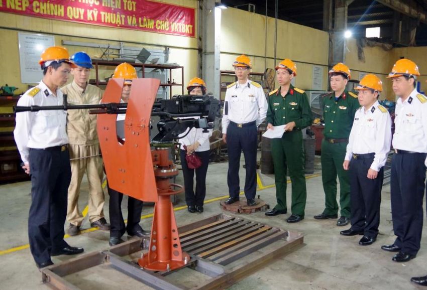
Content

About SCSPI................................................................................................... i

I. Construction in the Early Stage................................................................. 3

II. Massive Land Reclamation .................................................................... 12

III. Military Deployment on Vietnam-Occupied Features .......................... 30

IV. Conclusion ............................................................................................. 51
Expansion and Military Deployment on
  Vietnamese-Occupied Features in the Spratly Islands

                                          Chen Qi

     In 1975, Vietnam went back on its long-standing position over Spratly

islands in the South China Sea – these islands are part of China’s territory

– and occupied five ‘features seized by the Republic of Vietnam, or South

Vietnam with its capital in Saigon, in the name of “emancipating Quan Dao

Truong Sa” (an illegal name of the main islands and reefs of Spratly Islands

coined by Vietnam). As of 1998, the country invaded the other 24 islands

and reefs of Spratly Islands in succession, bringing the total number of

Vietnamese-occupied islands and reefs in the region to 29. Over the past

46 years, in order to reinforce its claimed “sovereignty” and develop

marine resources, Vietnam has painstakingly developed those occupied

islands and reefs of the Spratly Islands, irrespective of its weak national

strength and teetering economic conditions. Among all the Spratly Islands

claimants, Vietnam has occupied most of islands and reefs and was the first

to deploy heavy weapons to these features unceasingly for a long time.

       Expansion and Military Deployment on Vietnamese-Occupied Features in the siIslands   1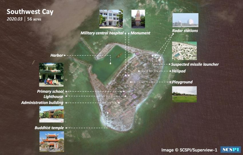
2 SCSPI | Promoting Transparency, Peace and Cooperation of the South China Sea
I. Construction in the early stage

     Given its feeble national strength and the woes arising out of the

lasting war at home, Vietnam merely managed to develop fairly rough

infrastructure on the Spratly Islands it held until the mid-1990s, the

majority of which was shabby bungalows and military fortifications. As the

country embraced economic prosperity enabled by the economic reform

and opening policies known as Đổi mới, the “Bien DongSea Project

Steering Committee” of the country launched into massive construction on

these islands and reefs. Even though this round of construction was not as

ambitious by today’s standards, it took great pains for Vietnam to assert its

presence on these islands. It built robust anti-landing fortifications systems

at beachheads, ramped up coast reinforcement and breakwaters and built

small artificial islands with natural sandbanks. The exquisite and compact

houses and yards on these islands bore evident ethnic marks. Soldiers and

civilians on these islands worked very hard to plant trees, grow vegetables

and fruits, and raise livestock and poultry. As a result, lush forests and row

upon row of houses sprang up on these islands, which took on a new look.

       Expansion and Military Deployments on Vietnamese-Occupied Features in the Spratly Islands
                                                                                 www.scspi.org     3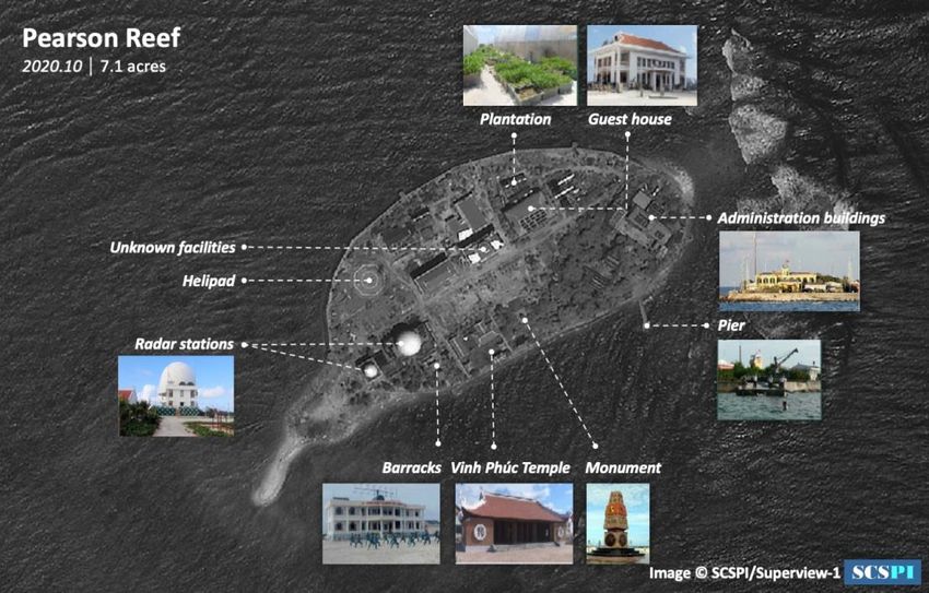
Comparison of the Sin Cowe Island in 1988 (above) and 2013 (below). Photo: thiemthu

       In June 1976, the Vietnamese military began to build a simple airport

with an airstrip that was 600 meters long and 24 meters wide on the Spratly

4   SCSPI | Promoting Transparency, Peace and Cooperation of the South China Sea
Island for the departure and landing of light fixed-wing transport aircraft
and helicopters. The airport was completed in August 1977, but it later fell
into disuse for a long time. It was not until April 2004 that the Vietnamese
military announced that it was about to restore the airport to “develop
tourism”. The airport kept a low profile since then. On March 19, 2014,
Vietnamese media reported for the first time that Vietnam’s DHC-6 Twin
Otter from the 954th Naval Air Force Regiment landed at the airport that
day. The southeast coast of the Spratly Island was in close proximity to the
deep-water zone at the edge of coral reefs, making it easier to develop
jetties. The pier on the Spratly Island was completed on August 27, 1994,
allowing Vietnam’s large-tonnage naval vessels to dock and greatly
improving the supplies and transport conditions on the island.
Expansion and Military Deployments on Vietnamese-Occupied Features in the Spratly Islands
www.scspi.org 5Airstrip and jetty on the Spratly Island in the early days. Photo: Photobucket
As to the deep reef banks in Southwest Spratly Islands, they are not
ideal destinations for land reclamation. For this reason, Vietnam had to
construct “DK1” rigs (they are officially called “Scientific-Technological
Economic Service Stations” and 1 indicates that they are rigs standing at
the peripheral of the continental shelf) just like Maunsell Forts of UK in
WWⅡ,armed with guardian vessels to occupy the area and maintain its
symbolic control of the “southern continental shelf” . Shoddy structures
built through Vietnam’s early offshore oil and gas engineering technology
frequently collapsed due to backward technology and inappropriate
structural design of these rigs. In recent years, however, Vietsovpetro has
basically modernized and upgraded these rigs into larger dual rigs with
6 SCSPI | Promoting Transparency, Peace and Cooperation of the South China Seabetter facilities. Together with guardian vessels, these “DK1” rigs could
monitor and expel foreign fishing vessels away from nearby waters, and
accommodate injured or sick Vietnamese fishermen for treatment, creating
favorable conditions for helicopters to pick up and rescue the sick and the
wounded. The distribution and brief history of these “DK1” rigs are as
follows—
1. Prince of Wales Bank
On June 15, 1989, Vietnam seized Prince of Wales Bank and established
the DK1/3 rig, which fell apart on the night of December 4, 1990 during a
storm. Three out of the eight soldiers falling into water died.
On August 18, 1993, the DK1/2 rig was completed, which was then
upgraded in 2015.
On August 20, 1996, the DK1/16 rig was completed, which was then
upgraded in 2017.
On August 23, 1996, the DK1/17 rig was completed, which was then
upgraded in 2017.
On April 13, 1997, the DK1/18 rig was completed, which was then
upgraded in 2017.
Expansion and Military Deployments on Vietnamese-Occupied Features in the Spratly Islands
www.scspi.org 7The DK1/3 rig at Prince of Wales Bank collapsed one year after it was put in place, due to an
unreasonable design. Photo: trian.vn
2. Bombay Castle
Vietnam occupied Bombay Castle on June 16, 1989 and set up the DK1/4
rig, which fell to pieces in a storm on the night of December 4, 1990 and
was never rebuilt.
3. Vanguard Bank
On June 27, 1989, Vietnam seized Vanguard Bank and established the
DK1/1 rig (it has been abandoned by now).
8 SCSPI | Promoting Transparency, Peace and Cooperation of the South China SeaOn November 2, 1989, the DK1/5 rig was completed (it has been
abandoned by now).
On May 5, 1994, the DK1/11 rig was completed, which was then upgraded
in June 2016.
On August 8, 1994, the DK1/12 rig was completed, which was then
upgraded in June 2016.
On April 20, 1995, the DK1/14 rig was completed, which was then
upgraded in 2011.
4. Prince Consort Bank
Vietnam seized Prince Consort Bank on November 4, 1990 and established
the DK1/6 rig on November 10, which collapsed in a storm on the night of
December 4.
On April 7, 1995, a new rig named 2A/DK1/6 was put together based on
the collapsed DK1/6 rig. On December 13, 1998, it fell apart again in
Typhoon Faith and three out of nine soldiers falling into water were killed.
In April 1995, the DK1/15 rig was completed in the south, which was then
upgraded in 2012.
Expansion and Military Deployments on Vietnamese-Occupied Features in the Spratly Islands
www.scspi.org 9The DK1/15 rig on Prince Consort Bank was receiving supplies for the Spring Festival in 2021.
Photo: VNA
5. Grainger Bank
Vietnam occupied Grainger Bank on November 3, 1991 and established
the DK1/8 rig on November 4, which was then upgraded in May 2015.
The DK1/19 rig was completed in the southwestern corner on April 10,
1997 and then upgraded in June 2017.
6. Alexandra Bank
Vietnam seized Alexandra Bank on November 11, 1991 and set up the
10 SCSPI | Promoting Transparency, Peace and Cooperation of the South China
SeaDK1/7 rig, which was then upgraded in the first half of 2014.
7. Bombay Castle (called Ba Kè B in Vietnam, namely Point B of the Ba
Kè Shoal)
Vietnam seized Bombay Castle on August 22, 1993 and established the
DK1/9 rig, which was then upgraded in 2015.
8. Kingston Shoal
Vietnam seized Kingston Shoal on July 7, 1998 and established the DK1/20
rig on August 13, which was then upgraded in June 2016.
9. Orleana Shoal
Vietnam seized Orleana Shoal on July 3, 1998 and established the DK1/21
rig on August 19, which was then upgraded in June 2016.
Expansion and Military Deployments on Vietnamese-Occupied Features in the Spratly Islands
www.scspi.org 11II. Massive Land Reclamation
Vietnam launched numerous land reclamation and harbor
construction projects to reinforce those illegally-held features, improve the
living standards and supplies of soldiers and civilians, boost the control
capacity over the sea and advance the exploitation of fishery resources. The
series of construction projects was kicked off in 2007 and brought to a
climax after 2015. Efforts are still being made to improve the construction
of facilities (due to the movements of sandbanks and tidal variations, the
land area listed below is for reference only).
Due to limited technology, Vietnam did not employ special dredgers
for these construction projects, but adopted two simple approaches:
1. First, it used excavators to build seawalls and cofferdams with coral
sand in the shallow water of coral reefs and then used excavators to dredge
sand from coral reefs on seawalls from both sides.
2. Next, excavators were loaded onto barges to form simple dredgers
for waterway excavation in the shallow waters.
12 SCSPI | Promoting Transparency, Peace and Cooperation of the South China
SeaPhoto of the construction site at the Sin Cowe Island, which displays the above two approaches to
harbor excavation and land reclamation on one of the Spratly Islands by Vietnam
Photo: nhjd.net
The stones used to build breakwaters at harbors were transported from
Vietnam by sea. In recent years, modern technologies like precast concrete
caissons and accropode blocks have been applied to the construction on
certain important islands and reefs.
Expansion and Military Deployments on Vietnamese-Occupied Features in the Spratly Islands
www.scspi.org 13Vietnamese naval personnel were building breakwaters at the harbor of the Sin Cowe Island.
Photo: nhjd.net
The breakwater of the harbor on West Reef was built by precast concrete caisson and accropode
blocks to dissipate waves and prevent scour. Photo: nhjd.net
14 SCSPI | Promoting Transparency, Peace and Cooperation of the South China
SeaLarge-scale land reclamation and harbor construction projects
launched on Vietnamese-occupied features of the Spratly Islands are listed
below in a chronological order:
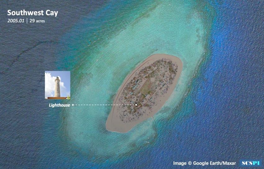
1. Southwest Cay
Since 2007, Vietnam has begun dredging sand from reefs in
Northwest Southwest Cay to construct harbors and breakwaters, and
created new landmass off the southern bank of the island, through which it
expanded the area of the island from 117,000 square meters to 225,000
square meters and developed a harbor that could accommodate 1,000-
tonnage vessels.
Expansion and Military Deployments on Vietnamese-Occupied Features in the Spratly Islands
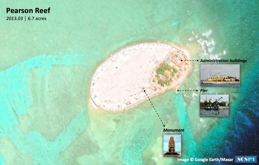
www.scspi.org 15Satellite image comparison of the Southwest Cay in 2005 and 2020 2. Pearson Reef 16 SCSPI | Promoting Transparency, Peace and Cooperation of the South China Sea
Since 2011, Vietnam has started dredging sand from the reef and

expanded the west side of the existing small artificial island (built with

natural sandbank) on Point A in East Pearson Reef via reclamation,

increasing the total area of land from 6,000 square meters to around 30,000

square meters.

       Expansion and Military Deployments on Vietnamese-Occupied Features in the Spratly Islands
                                                                                www.scspi.org 17
Satellite image comparison of Pearson Reef in 2013 and 2020.
The area with luxuriant vegetation in the east is the original island
3. Central Reef
Since 2011, Vietnam has expanded the south side of the existing small
artificial island (built with natural sandbank) located in East Zhong Jiao
Central Reef via reclamation, expanding the area of the island from 9,000
square meters to 20,000 square meters.
18 SCSPI | Promoting Transparency, Peace and Cooperation of the South China
SeaSatellite image comparison of Central Reef in 2009 and 2013.
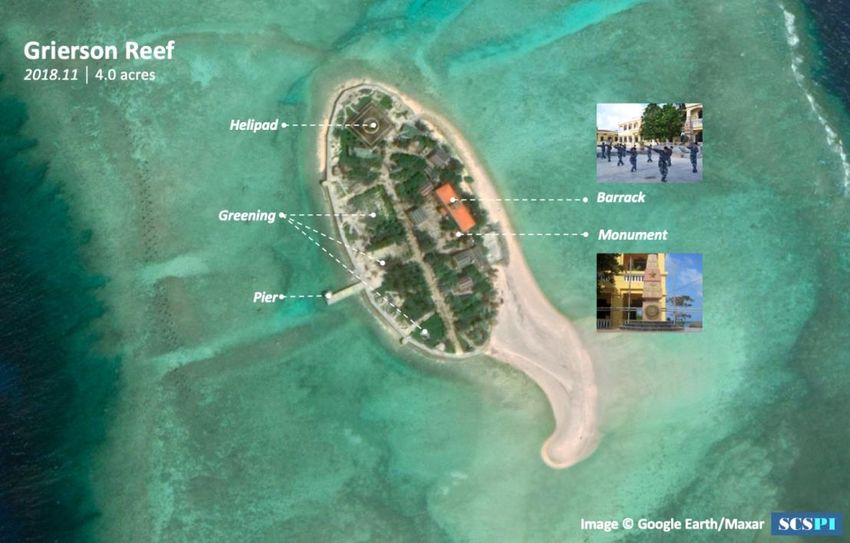
4. Grierson Reef
Expansion and Military Deployments on Vietnamese-Occupied Features in the Spratly Islands
www.scspi.org 19Since 2012, Vietnam kicked off land reclamation in the west of
Grierson Reef, expanding the area of the reef from 6,000 square meters to
26,000 square meters.
Satellite image comparison of Grierson Reef in 1995 and 2018
20 SCSPI | Promoting Transparency, Peace and Cooperation of the South China
Sea5. West Reef
Since 2013, Vietnam has begun building harbors and expanding the
island on the small artificial island in Point A of the southeastern reef flat
of West Reef (which is called East Island of Xi Jiao in China and built with
natural sandbank). It excavated the inner fringing reef of the artificial
island to build an artificial harbor. The coral sand dredged was used to build
a large artificial island to the east of the artificial island and three reef forts,
expanding the land area from 6,000 square meters to roughly over 90,000
square meters. The newly built artificial harbor has become Vietnam’s
fishery base in the Spratly Islands. The 130,000-square-meter harbor basin
could accommodate 200 small fishing vessels and allow 1,000-tonnage
supply vessels to come in. A new fisherman village and outdoor slipway
providing repair services for small naval and fishing vessels have also been
set up on the artificial island.
Expansion and Military Deployments on Vietnamese-Occupied Features in the Spratly Islands
www.scspi.org 21Satellite image comparison of West Reef
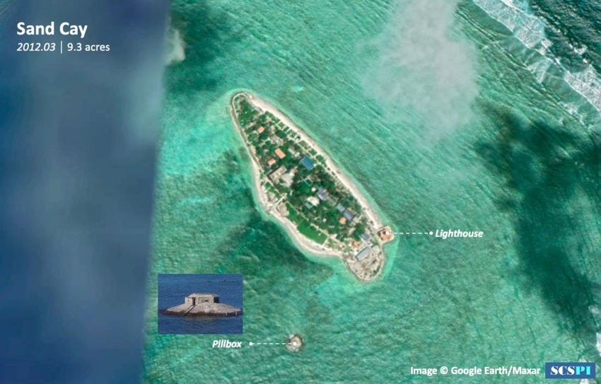
6. Sand Cay
Vietnam has started reclaiming land from the sea on Sand Cay since
2013, expanding the area of the island from 35,000 square meters to 66,000
square meters.
22 SCSPI | Promoting Transparency, Peace and Cooperation of the South China
SeaSatellite image comparison of Sand Cay in 2004 and 2020
Expansion and Military Deployments on Vietnamese-Occupied Features in the Spratly Islands
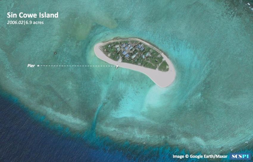
www.scspi.org 237. Sin Cowe Island
Vietnam has started the construction of a harbor basin and land
reclamation on the Sin Cowe Island since April 2014, through which it
expanded the area of the island from 40,000 square meters to 130,000
square meters. The harbor basin was completed by the end of 2015. It
covers an area of 32,000 square meters and is 4.5 meters deep, with a five-
meter-deep waterway. It allows 1,000-tonnage vessels to dock.
24 SCSPI | Promoting Transparency, Peace and Cooperation of the South China
SeaSatellite image comparison of Sin Cowe Island in 2006 and 2020
8. Cornwallis South Reef
In early April 2015, Vietnam dredged two waterways in east and west
Cornwallis South Reef respectively, making the lagoon a haven. These two
waterways (the one in the east is approximately 85 meters wide and 440
meters long and the one in the west is approximately 80 meters wide and
440 meters long) were completed by August. In the meantime, it built two
artificial islands via reclamation with the sand dredged, increasing the total
area to over 90,000 square meters. In December, the land reclaimed from
the sea was basically ruined by sea waves, so only two small artificial
islands were maintained after reinforcing the coast. The areas of the eastern
and western islands are estimated to be 2,300 square meters and 2,100
Expansion and Military Deployments on Vietnamese-Occupied Features in the Spratly Islands
www.scspi.org 25square meters respectively.
Satellite images of the waterways of Cornwallis South Reef
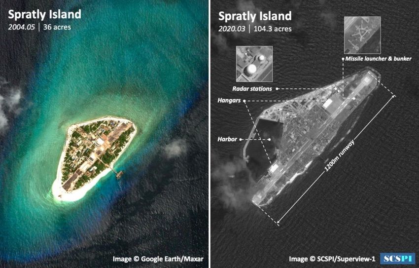
9. Spratly Island
Since April 2015, Vietnam has launched a large-scale land
reclamation project to expand the Spratly Island, including airstrip
extension and excavated harbor basin construction. As a result, the land
area was expanded from 0.15 square kilometers to over 0.4 square
kilometers and the airstrip was extended to 1,200 meters (1,300 meters
with the buffer zone counted in). The harbor could accommodate 2,000-
tonnage vessels.
26 SCSPI | Promoting Transparency, Peace and Cooperation of the South China
SeaSatellite Image Comparison of the Spratly Island
10. Ladd Reef
Since October 2016, Vietnam began to develop waterways in the
southern coral reefs of Ladd Reef to connect the lagoon to the open waters,
thus making the lagoon a small haven. In February 2018, new signs of land
reclamation were spotted in the northern coral reefs of Ladd Reef,
increasing the land area by approximately 1,000 square meters.
Expansion and Military Deployments on Vietnamese-Occupied Features in the Spratly Islands
www.scspi.org 27Satellite Image of the Completed Waterway and A New Land of Ladd Reef in 2018
The development of harbors and the expansion of airports and
landmass are of great significance for Vietnam’s occupation and actions in
the Spratly Islands. With much better transport conditions of airborne and
seaborne supplies, more installations are set up on those islands, creating
more space for water supply and power generation facilities, houses, heavy
weapons and equipment, and offering havens for vessels. Meanwhile,
fishermen could replenish their supplies and sell their aquatic products to
those islands.
28 SCSPI | Promoting Transparency, Peace and Cooperation of the South China
SeaAnnex: Overview of Vietnamese-Occupied Features in the
Spratly Islands
Note 1: The built rigs on the southwestern reefs and shoals of the Spratly Islands are equipped with helipads and
some rigs also serve as lighthouses. Helipads and lighthouses are not independent structures.
Note 2: The statistics of areas do not include that of reef forts and the floor area of rigs.
Note 3: Neither China nor Vietnam has officially named the southeastern coral reef of Bombay Castle yet.
Expansion and Military Deployments on Vietnamese-Occupied Features in the Spratly Islands
www.scspi.org 29III. Military Deployment on Vietnam-Occupied
Features
Though Vietnam has tried to trumpet that the islands and reefs of the
Spratly Islands held by it are for civilian uses, they actually have a strong
military dimension. A great number of personnel and equipment from the
Vietnamese troops and paramilitary forces have been setting up defenses
and operating on these islands and reefs.
1. Naval Garrison Force
The Vietnamese-occupied features of the Spratly Islands are covered
by the Naval Regions 2 and 4 of the Vietnamese Navy, where two units of
main garrison forces are stationed: Naval Infantry Brigade 146, Naval
Region 4 which is based in the Quan Dao Truong Sa (Spratly Islands), and
Battalion DK1, Naval Region 2 High Command (originally Flotilla 171)
which is defending the DK1 rigs.
Naval Infantry Brigade 146, Naval Region 4 was formerly the
Vietnamese Navy’s Garrison Regiment 146 for the Spratly Islands
(expanded in 1980), which played a very important role in the operation of
“seizing” the Spratly Islands in 1978 and was heavily hit by the Chinese
People’s Liberation Army (PLA) in the “ 1988 Johnson South Reef
30 SCSPI | Promoting Transparency, Peace and Cooperation of the South China
SeaSkirmish”. Stationed in the Cam Ranh Bay, the Brigade Headquarter has
purview over two battalions and several directly affiliated companies,
whose troops rotate at regular intervals. For a long time, the Brigade has
performed garrison and anti-landing operations on the islands and reefs of
the Spratly Islands and stopped foreign ships from approaching these
islands and reefs to gain control of the waters. It is reported that over 2,000
soldiers have been deployed to defend the islands and reefs.
In 2020, nine Type-65 twin barrel 37mm anti-aircraft guns, provided by China as aid, were
shipped to the Vietnamese-held features of the Spratly Islands to build up defenses.
Photo: QPVN.vn
In terms of fortifications, Brigade 146 constructs fortress-style,
blanket defensive positions by combining field and permanent
fortifications, setting up both ground battlefields and underground bunkers,
Expansion and Military Deployments on Vietnamese-Occupied Features in the Spratly Islands
www.scspi.org 31and building both combat and living facilities, which are supported by reef forts, so as to form a system of “key-point defense” on ten islands and reefs of the Spratly Islands (Southwest Cay, Sand Cay, Namyit Island, Sin Cowe Island, Spratly Island, Amboyna Cay, Grierson Reef, Pearson Reef, Central Reef and West Reef). Vietnam has deployed plenty of troops and weapons to these islands and reefs because of their favorable living conditions. In particular, the Spratly Island and the Namyit Island are two core braces for the line of defense for features of the Spratly Islands, where battalion-level units of troops are stationed. The most powerful artillery on these islands is composed of towed 122mm howitzers and 130mm cannons, and the air defense firepower is enabled by old-type 23mm and 37mm anti-aircraft guns. Meanwhile, old T-34/85 medium tanks and PT-76 amphibious light tanks which were provided by the former Soviet Union as aid, Type-63 amphibious light tanks which were provided by China as aid, and tank turret forts constitute their flexible and fixed anti-landing gun emplacements. In addition, a VRS-CSX X-band medium-range coastal warning radar system, which is developed by Viettel (modeled on the Score 3000 radar system of France’s Thales Group) and capable of detecting targets at a distance of up to 170 kilometers, has been installed on these islands. 32 SCSPI | Promoting Transparency, Peace and Cooperation of the South China Sea
Vietnam’s Type-63 amphibious light tanks on the Southwest Cay. Photo: nhjd.net

     On the other 11 reefs (South Reef, Petley Reef, Great Discovery Reef,

Lansdowne Reef, Collins Reef, Pigeon Reef, Cornwallis South Reef,

Alison Reef, Barque Canada Reef, East Reef and Ladd Reef), the

Vietnamese forces have developed dotted defensive facilities, such as

clusters of reef forts to form a structure of “loose defenses” , enabling

interaction between different facilities. Roughly a squad of soldiers is

assigned to each reef fort which is fitted with anti-aircraft machine guns,

RPG-7 and Kalashnikov assault rifles, as well as several machine gun

bunkers and a speedboat in general. Before 2011, the defenders of the reef

forts on the Vietnamese-occupied features of the Spratly Islands had many

times forcibly expelled or shot Chinese fishermen who engaged in fishing

       Expansion and Military Deployments on Vietnamese-Occupied Features in the Spratly Islands
                                                                                www.scspi.org 33
around reefs and shoals.
Structure of the Reef Fort on the Ladd Reef
Flotilla 171, Naval Region 2 was the principal force in the Vietnamese
troops’ occupation of the southwestern reef banks of the Spratly Islands in
the 1980s and 1990s. Stationed in the Bach Dang Port, Ho Chi Minh City,
the Flotilla set up its frontline command in Vũng Tàu and performed
maritime maneuver operations in three groups. The Flotilla took charge of
garrisoning the DK1 rigs from 1989 to 2009, and is now still responsible
for replenishing supplies and protecting them.
Starting from 2009, the DK1 rigs have been garrisoned by Battalion
DK1, Naval Region 2 High Command. A squad of soldiers is deployed to
each of these rigs which are equipped with meteorological instruments,
34 SCSPI | Promoting Transparency, Peace and Cooperation of the South China
Seanavigation radars, infrared photovoltaic surveillance equipment and steel
bunkers for anti-aircraft machine guns. Large and medium-sized
helicopters can take off from and land on the deck at the top of these rigs.
The troops stationed on these rigs total around 150. Battalion DK1
comprises several hundred soldiers who rotate to garrison the rigs at
regular intervals.
A Type-54 12.7mm Anti-aircraft Machine Gun Provided by China as Aid on the DK1 Rig.
Photo: Thanhuytphcm.vn
2. Air Force Radar Troops Stationed on the Islands
Formerly known as Radar Battalion 297 under Air Defense Brigade
37, Radar Regiment 292 under Air Division 377 has established four radar
stations on the Spratly Islands, including Radar Station 11 (Spratly Island),
Radar Station 21 (Southwest Cay), Radar Station 44 (Pearson Reef) and
Expansion and Military Deployments on Vietnamese-Occupied Features in the Spratly Islands
www.scspi.org 35Radar Station 57 (Namyit Island). Built up between 1988 and 2008, these four radar stations are responsible for delivering anti-air early warning above the Spratly Islands and guiding fighters to perform patrols over the open seas. The replacement of the old-type Soviet-manufactured P-18 metric-wave long-range air early-warning radars with the Czech P-18M digital radars, which are fitted with a spherical antenna radome, was started from 2016 and completed in May 2018. The P-18M radar can effectively detect targets within a range of 300 kilometers, which covers most islands and reefs of China’s Spratly Islands. With four more anti-jamming antenna modules installed, an Identification Friend or Foe (IFF) system was integrated to automatically track 200 targets per second. In 2019 and 2020, a second air radar was installed in each of the four radar stations, and triangular launch sites for vehicle-mounted anti-aircraft missiles were set up in the stations as well. Moreover, chances are that the anti-aircraft missile troops of the Vietnamese Air Force have been stationed on the islands for regular training. 36 SCSPI | Promoting Transparency, Peace and Cooperation of the South China Sea
Radar Station 44 on the Pearson Reef (On the right side). Photo: VNA

                          Satellite Image of the Spratly Island in 2020

    radar station 11, and anti-aircraft missile and artillery emplacement with tunnel bunkers

3. Naval Replenishment Ships

     Transportation Brigade 125, Naval Region 2 of the Vietnamese Navy

was formerly Regiment 125 known for opening up the Ho Chi Minh Sea

Trail. It landed on uninhabited islandsSouthwest Cay of the Spratly Islands

for reconnaissance in 1972, participated in operations to seize several

islands of the Spratly Islands in 1975, and was battered by the Chinese

military in the Johnson South Reef Skirmish in 1988. As a major force to

transport supplies to the Vietnamese-held features of the Spratly Islands, it

        Expansion and Military Deployments on Vietnamese-Occupied Features in the Spratly Islands
                                                                                 www.scspi.org 37
consists of five naval squadrons. The Brigade Headquarters and Naval
Squadrons 4 and 6 are stationed in Haiphong, and its frontline command
and Naval Squadrons 1, 3 and 5 are based in Ho Chi Minh City. It is now
armed with over 20 amphibious vessels and logistic support ships.
HQ-503 and HQ-501, Two US-manufactured Tank Landing Ships (formerly used in World War
II) of Transportation Brigade 125. Photo: People’s Army Newspaper
4. Naval Training Troops
Marine Corps Brigade 126, Naval Region 4 of the Vietnamese Navy
was formed based on Naval Commando Regiment 126, and participated in
the combat to seize several features of the Spratly Islands in 1975. Now
stationed in the Cam Ranh Bay, it contains Naval Commando Regiment
861, four marine battalions, two armor battalions, two artillery battalions,
38 SCSPI | Promoting Transparency, Peace and Cooperation of the South China
Seaone anti-aircraft gun battalion, as well as one engineer company, one signal
company and one surveillance company. Its equipment mainly includes:
amphibious tanks, armored vehicles, mortars, cannons, recoilless rifles,
anti-aircraft guns, etc. Naval Commando Regiment 861 would carry on
training in the Spratly Islands for three times a year and each for one month,
mainly to learn about various underwater combat skills.
Naval Commando Regiment 861 was exercising the landing and attack on reef forts of the Spratly
Islands in the training base. Photo: nhjd.net
Coastal Defense Missile and Artillery Brigade 685, Naval Region 4
of the Vietnamese Navy is equipped with Israeli-manufactured EXTRA
dual-barrel 306mm extended-range rocket artilleries, which have a
maximum range of 150 kilometers. Reports suggested that the Brigade
Expansion and Military Deployments on Vietnamese-Occupied Features in the Spratly Islands
www.scspi.org 39deployed such rocket artilleries to five islands and reefs of the Spratly
Islands in 2016,1 and satellite images also showed emplacements which
are believed to be built for rocket artilleries. These rocket artilleries could
be for training purposes, instead of being permanently installed. As
Vietnam has been occupying more and more islands and reefs, there is a
possibility that the Vietnam military will normalize the deployment of
missile weapons to these features.
The Vietnam military’s Israeli-manufactured EXTRA extended-range rocket artilleries, fitted with
fixed launchers
5. Naval and Air Force Aviation
Transportation Regiment 918 (“Hong Ha”) under the Air Division 371
(“Thăng Long”) is armed with five C-212-400MP/NC212i MSA maritime
1 Exclusive: Vietnam moves new rocket launchers into disputed South China Sea - sources, Reuters, Aug 10, 2016,
https://www.reuters.com/article/us-southchinasea-vietnam-exclusive-idUSKCN10K2NE
40 SCSPI | Promoting Transparency, Peace and Cooperation of the South China
Seapatrol aircraft (the other aircraft models owned by the Regiment are
omitted here; similarly hereinafter), including two C-212-400MP aircraft
by Airbus Defense and Space SA (formerly EADS CASA) in Spain
(another C-212-400MP aircraft, in addition to the two listed here, crashed
into the sea) and three NC212i MSA aircraft by PT Dirgantara (PTDI) in
Indonesia. The former is painted with the colors of the Vietnamese Coast
Guard, and the latter is painted with the colors of the Air Force transport
aircraft. The abovementioned aircraft often take off from and land at the
airport on the Spratly Island to carry out missions.
A C-212-400MP aircraft (numbered 8983) landed at the airport on the Spratly Island (it crashed in
2016). Photo: xuandienhannom.blogspot.com
Expansion and Military Deployments on Vietnamese-Occupied Features in the Spratly Islands
www.scspi.org 41A NC212i MSA Aircraft landed at the Airport on the Spratly Island.
Photo: QPVN
Stationed in the Tan Son Nhut Air Base, Ho Chi Minh City, Mixed
Transport Regiment 917 (“Đồng Tháp”) under Air Division 370 (“Lê Lợi”)
is a transport helicopter unit. Its Russian Mil Mi-171 helicopters often fly
to far-off Vietnamese-held features of the Spratly Islands for rescue
missions. The unit is experienced in open-sea flight of helicopters. In
carrying out rescue missions to the Nanzi Island (Southwest Cay), its
helicopters can make a round-trip of up to 1,660 kilometers and operate for
as long as seven hours and 46 minutes in the air.
42 SCSPI | Promoting Transparency, Peace and Cooperation of the South China
SeaA Mi-171 Helicopter of Mixed Transport Regiment 917 landed on the DK1/10 Rig.
Photo: baotainguyenmoitruong.vn
Naval Aviation Brigade 954 of the Vietnamese Navy has six
Canadian-manufactured DHC-6–400 Twin Otter amphibious aircraft.
Three of them, refitted as Guardian 400MPA maritime patrol aircraft, are
used for maritime patrol missions and SAR (Search and Rescue) operations
and are equipped with a nose-mounted radar and an electro-optical/infrared
(EO/IR) sensor. One of the other three aircraft is utilized for VIP transport
and the remaining two as commuter aircraft of these features. The
abovementioned aircraft often take off from and land at the airport on the
Nanwei Island (Spratly Island) to execute missions, and their floats can be
removed quickly to enable a regular ground-based plane configuration and
deliver better airworthiness.
Expansion and Military Deployments on Vietnamese-Occupied Features in the Spratly Islands
www.scspi.org 43A DHC-6–400 amphibious aircraft of Naval Aviation Brigade 954 landed at the airport of the
Spratly Island. Photo: tienphong.vn
6.Paramilitary Forces
Southern Vietnam Helicopter Company (VNH South, formerly
known as Petroleum Helicopter Company), a company owned by Vietnam
Helicopter Corporation (Army Corps 18) which is directly affiliated to the
Vietnamese Air Force, is one of the country’s major helicopter operators in
the South China Sea. It is mainly responsible for commuting and rescue
missions between the offshore oil and gas rigs, features of the Spratly
Islands and DK1 rigs and the country’s territory. It now operates
44 SCSPI | Promoting Transparency, Peace and Cooperation of the South China
SeaEurocopter EC225 Super Puma helicopters, AS365 Dauphin II helicopters,
Russian Mil Mi-8/17 helicopters, etc. It is a military-run company with
Vietnamese characteristics, and its pilots wear the Vietnamese Air Force
uniforms.
An EC225 helicopter of VNH South was taking off from or landing at the Southwest Cay.
Photo: sieuthinhanh.com
Naval Battalions 128 and 129, under the Bien Dong Seafood
Company, Ltd. which is directly affiliated to the Vietnamese Navy.
Headquartered in Haiphong, Naval Battalion 128 was formerly Vietnamese
Navy’s Armed Fishing Vessel Regiment 128, which was established in
1971. Headquartered in Ho Chi Minh City and Vũng Tàu, Naval Battalion
Expansion and Military Deployments on Vietnamese-Occupied Features in the Spratly Islands
www.scspi.org 45129 (Truong Sa Marine Products One Member Limited Liability Company)
was formerly Vietnamese Navy’s Armed Fishing Vessel Regiment 129,
which was established in 1978. Both companies are managed by the Navy’s
Saigon Newport Corporation from 2018. In 2016, Naval Battalion 129
established “Logistic and Technical Service Centers” on four Vietnamese-
occupied features of the Spratly Islands, namely the Spratly Island, Sin
Cowe Island, Cornwallis South Reef and Alison Reef. Naval Battalion 128
established a fisheries logistics service station on the Southwest Cay. In
addition, another key business of the two companies is to provide warning
and guarding services for Vietnam’s offshore oil and gas exploration and
exploitation.
No. 798 Armed Fishing Vessel of Naval Battalion128. Photo: vovgiaothong.vn
46 SCSPI | Promoting Transparency, Peace and Cooperation of the South China
SeaThe No. 640 transportation ship of Naval Battalion 129 was towing and rescuing a Vietnamese
fishing vessel which ran out of steam due to mechanical defects.
Photo: baotainguyenmoitruong.vn
As the maritime law enforcement bodies, the Vietnam Coast Guard
and fisheries resources surveillance forces have been equipped with a great
deal of new-type armed law enforcement vessels in recent years and
operated quite actively in the waters near the Spratly Islands. The patrol
areas of the Vietnam Coast Guard include Coast Guard Region III (main
body of the Spratly Islands), of which the command is based in Vung Tau,
and Coast Guard Region IV (southwestern reef banks of the Spratly Islands
and Gulf of Thailand), of which the command is located in Cà Mau. The
main strength of Vietnamese fisheries resources surveillance forces
Expansion and Military Deployments on Vietnamese-Occupied Features in the Spratly Islands
www.scspi.org 47operating in the Spratly Islands is Fisheries Resources Surveillance
Squadron 4, which also transport navy personnel and replenishments to the
Vietnamese-held islands and reefs.
In 2019, a TT400-class Vietnamese Coast Guard vessel, numbered CSB-4039, of Squadron 401
under Coast Guard Region 4 Command was confronting a Chinese fishing vessel in the waters
north of the Vanguard Bank. Photo: QĐND
48 SCSPI | Promoting Transparency, Peace and Cooperation of the South China
SeaA KN750-class Fisheries Resources Surveillance Ship in the newly built harbor Basin of the
Spratly Island KN750
Maritime militia (known as “Dân quân biển” in Vietnamese) refers to
grassroots militiamen of coastal communes (townships). Each commune
comprises one to two three-squad militiaman platoons, and each squad,
consisting of nine to ten militiamen, is equipped with a fishing vessel or
several small ones. The Vietnamese maritime militia self-defense force will
soon be equipped with 126 TK-1482 ships, a class of 400-tonnage ironclad
fishing vessels, which will be used for maritime SAR, logistics and armed
fisheries protection duties.
In 2020, the TK-1482 ironclad fishing vessels of the Vietnamese maritime militia self-defense
force were mass-manufactured. Photo: QPVN
Expansion and Military Deployments on Vietnamese-Occupied Features in the Spratly Islands
www.scspi.org 49NSV heavy machine gun with shield of the TK-1482 ironclad fishing vessels.
Photo: https://baohaiquanvietnam.vn
50 SCSPI | Promoting Transparency, Peace and Cooperation of the South China
SeaIV. Conclusion
Overall, constrained by the national strength and engineering capacity,
the construction on the Vietnamese-held features of the Spratly Islands is
no match for China’s in terms of both scale and speed. However, given its
long-term, covert and comprehensive nature, it should be regarded as a
high concern among the international community. As the Vietnamese
troops and civilians have become increasingly active in the Vietnamese-
held islands and reefs as well as the surrounding waters, the risk of any
friction and conflict couldn’t be belittled.
Expansion and Military Deployments on Vietnamese-Occupied Features in the Spratly Islands
www.scspi.org 51You can also read