Facies Distribution and Temporal Evolution of Faults in the Southern German Molasse Basin: A Case Study of Geretsried, Germany - European ...
←
→
Page content transcription
If your browser does not render page correctly, please read the page content below
European Geothermal Congress 2019
Den Haag, The Netherlands, 11-14 June 2019

Facies Distribution and Temporal Evolution of Faults in the Southern German
             Molasse Basin: A Case Study of Geretsried, Germany

            Vladimir Shipilin1, 2, Hartwig von Hartmann1, David C. Tanner1, Inga Moeck1, 2
                       1
                           Leibniz Institute for Applied Geophysics, Stilleweg 2, D-30655 Hannover
                              2
                                  University of Göttingen, Goldschmidtstr. 3, D-37077 Göttingen
                                                vladimir.shipilin@leibniz-liag.de

Keywords: German Molasse Basin, Upper Jurassic                      With increasing depth of the geothermal reservoir,
carbonate platform, Play Type, facies distribution, fault           fracture and fault density become the primary factors
kinematics, fault controlled reservoirs, geothermal                 that govern heat transport (Moeck, 2014). Foreland
exploration.                                                        basins reveal complex deformation structures that
                                                                    range from extensional faults toward the foreland to
ABSTRACT                                                            contractional and inverted faults near the orogenic front
                                                                    (Tavani et al., 2015). Therefore, understanding of
Recently, foreland basins have become prime targets to
                                                                    tectonic evolution and fault kinematics is crucial to
host geothermal resources because of the existence of
                                                                    evaluate potential geothermal reservoirs that lie at the
deep aquifers. Understanding of tectonic evolution,
                                                                    required depths. Depending on the kinematic evolution
fault kinematics, and facies within the reservoir, i.e. the
                                                                    and position in the current stress field, faults can act as
geothermal play type, is crucial to evaluate the potential
                                                                    hydraulic conduits or barriers.
for geothermal energy production. Based on a 3D
seismic survey, acquired 30 km south of Munich, we                  Our working area is within the southernmost part of the
analysis the facies within the carbonate platform and               German Molasse Basin (Fig. 1) — a typical foreland
the faults within the entire stratigraphic sequence of the          system. A number of basin-scale structural studies were
geothermal prospect of Geretsried in the southern                   carried out in the 80s and 90s, based on a large amount
German Molasse Basin. To determine the temporal                     of 2D seismic data acquired during the decades of
activity of the interpreted faults, we built a 3D                   hydrocarbon exploration (e.g. Bachmann et al., 1982;
geological model, from which we derived juxtaposition               Bachmann et al., 1987; Müller et al., 1998; Bachmann
diagrams of the faulted strata and thickness maps of                and Müller, 1992). However, until recently there have
seismic horizons. We show that the various strata at                been only a few detailed structural studies in relatively
Geretsried have undergone different deformation                     weakly-deformed parts of the foreland basin. Only with
phases; extension in the pre- and early-orogenic stages             the emergence of geothermal exploration in the recent
of basin formation and contraction in the Middle                    years and the consequent availability of 3D seismic
Miocene times. Furthermore, the deformation style at                data, have such studies become possible (e.g. Lüschen
this part of the basin is characterised by decoupled                et al., 2011; von Hartmann et al., 2016; Budach et al.,
faulting. The identified structures, their temporal                 2017).
activity, and deformation style indicate active stress
                                                                    In the present work, as the first step we carry out
regime and thus provide an insight into the hydraulic
                                                                    classical sequence stratigraphic analysis in order to map
transmissivity of the fault zones.
                                                                    favourable facies that might possess high initial
                                                                    porosities. The focus of the work, however, is an in-
                                                                    depth analysis of deformation structures within the
1. INTRODUCTION                                                     geothermal prospect of Geretsried. Our aim is to
In the last decade, there has been an increasing interest           understand the structure and tectonic evolution of an
in foreland basins to host geothermal resources because             area proximal to the Alpine deformation front to
of the existence of deep aquifers (e.g. Schulz et al.,              optimize the geothermal exploration. As the second
2004; Weides and Majorowicz, 2014). Fluid migration                 step, we analyse fault patterns within the Upper Jurassic
pathways in the foreland basins are controlled by facies            carbonate reservoir and its Molasse overburden. In
distribution and fault inventory within a geothermal                particular, using juxtaposition (Allan) diagrams (Allan,
reservoir (Moeck, 2014). The main targets of                        1989) and thickness maps, we establish the relationship
geothermal wells are massive carbonate facies that                  between sedimentation and faulting, as well as the
consist of reef bodies. Reconstruction of the                       temporal activity of faults. Based on the kinematic
depositional environment and understanding of facies                history of the faults and their orientation within the
distribution are therefore of the utmost importance for             present-day stress field, we discuss the implications for
successful geothermal exploration, as it provides hints
to the lithological properties, such as initial porosity.
                                                                                                                             1
Shipilin et al.

the hydraulic connectivity of the deformation structures     the north (Bachmann et al., 1982; Bachmann and
within the deep geothermal reservoir.                        Müller, 1992).
2. GEOLOGICAL SETTING                                        The Cenozoic Molasse cover was deposited in the
The German Molasse Basin (GMB) is part of the North          course of two major transgressive-regressive cycles and
Alpine Foreland Basin that evolved on the subducting         can be subdivided into, from base to top; the Lower
European margin in front of the Alps since the Late          Marine Molasse (UMM), the Lower Freshwater
Eocene (Lemcke, 1973; Bachmann et al., 1982). The            Molasse (USM), the Upper Marine Molasse (OMM),
Cenozoic deposits of the foreland basin unconformably        and the Upper Freshwater Molasse (OSM) (Eisbacher,
overlie the peneplained Mesozoic sedimentary                 1974; Fig. 2). The lowermost UMM consists of a
basement and locally, Permo-Carboniferous clastic            transgressive sequence that ranges from shallow-
sediments and crystalline rocks (Lemcke, 1988;               marine sandstones and carbonates, to deep-water
Sissingh, 1997).                                             condensed shales and marls (Lemcke, 1988; Sissingh,
                                                             1997). This sequence passes upward into thick
From Jurassic to middle Cretaceous times, the pre-           Rupelian Clayey Marls that were deposited during a
Molasse region evolved into an extensional passive           sea-level standstill (Zweigel et al., 1998). Transition
margin (Frisch, 1979; Ziegler, 1990; Pfiffner, 1992).        from UMM to USM is marked by the accumulation of
Submergence of the southern European shelf by the            regressive, shallow-marine to coastal Baustein Beds
Tethys Ocean in the Late Jurassic led to the deposition      (Diem, 1986). These are overlain by fluvial Chattian
of a gently-dipping Upper Jurassic carbonate platform        and Aquitanian Sands.
(Meyer and Schmidt-Kaler, 1990). At the present day,
it serves as the main aquifer for the geothermal energy      Despite decreased subsidence in the Burdigalian, the
production in the Molasse Basin. In the study area, the      second transgressive-regressive cycle began with
carbonate platform is overlain by thin, lithologically       transgression of OMM clay marls over the Aquitanian-
heterogeneous      Cretaceous      sediments    (Fig. 2;     Burdigalian erosional unconformity (Lemcke, 1988;
Bachmann et al., 1987).                                      Zweigel et al., 1998). By the beginning of Langhian,
                                                             terrestrial conditions prevailed across the entire GMB,
After a profound hiatus in sedimentation caused by the       as OSM was deposited (Lemcke, 1988). From ca.
Late Cretaceous contractional event, the deposition          8.5 Ma onwards, the GMB has experienced
resumed in the Late Eocene (Ziegler 1995). It marks the      isostatically-induced uplift and erosion (Lemcke,
inception of the foreland basin in response to the Euro-     1974). Our study area is within a weakly deformed part
Adriatic collision (Frisch, 1979; Allen et al., 1991;        of the basin, referred to as Foreland Molasse
Ziegler 1995). Loading and consequent flexure of the         immediately north of the frontal thrust of the Subalpine
European foreland plate created a wedge-shaped basin         Molasse. The Subalpine (Folded) Molasse was formed
fill (Allen et al., 1991). Flexural subsidence was           by thrusting and incorporation of the proximal foreland
accompanied by the formation of longitudinal (i.e.           basin sediments into the Alpine front (Bachmann et al.,
foredeep-parallel) normal faults, which show                 1987; Reinecker et al., 2010).
successively younger syn-sedimentary activity toward

Figure 1: Location map. Left: outline of the German Molasse Basin with geothermal areas (www.geotis.de), right:
      location of the Geretsried 3D seismic survey. Black line marks profile within the survey area in Fig. 4, blue
      lines are major normal faults.

2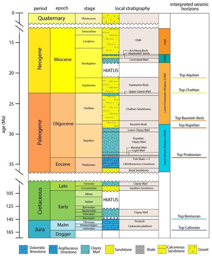
Shipilin et al.

                                 Figure 2: Detailed stratigraphy of the analysed area.

The Subalpine Molasse units are detached from the              data from the Geretsried GEN-1 well, which was drilled
lowermost Foreland Molasse and its Mesozoic                    down to the intermediate part of the Upper Jurassic
substrate by a major décollement within the                    carbonate platform. The well data comprises detailed
mechanically weak Rupelian Clayey Marl (Bachmann               lithostratigraphic log and vertical seismic profiling.
et al., 1982; Ortner et al., 2015). The thrusting activity
in the Alps abated in Early to Middle Miocene times            The seismic cube was depth migrated in the pre-stack
(Zweigel, 1998). However, thermochronological data             domain and tied to the Geretsried GEN-1 well with the
suggests that thrusting in the Subalpine Molasse               help of a vertical seismic profile. Six horizons were
continued into the Late Miocene (von Hagke et al.,             mapped using lithological markers from the Geretsried
2012).                                                         GEN-1 well; from the top of the Upper Jurassic
                                                               aquifer/Purbeckian facies, which corresponds to the top
3. DATA AND METHOD                                             Berriasian, up to the highest seismically recognizable
                                                               horizon — the top Aquitanian (Figs. 2, 4). The base of
Our study is based on a 40 km2 large 3D seismic survey,
                                                               the carbonate platform, which was not intercepted by
acquired 30 km south of Munich in 2010 (Fig. 1). The
                                                               the well, was predicted, based on the relatively uniform
maximum CMP fold was 163 m. Bin size was 25 m x
                                                               600 to 650 m thickness of the platform in the southern
25 m. The seismic reflection data are supplemented by
                                                               part of the GMB.

                                                                                                                       3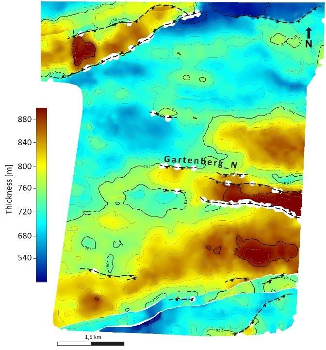
Shipilin et al.
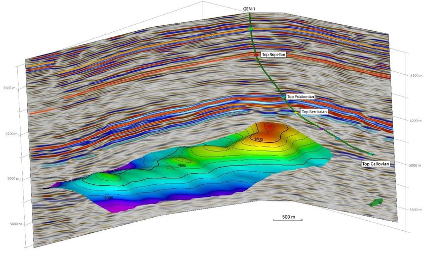
Figure 3: Depth map of the interpreted organic build-up within the Upper Jurassic aquifer.
For the facies interpretation in the Upper Jurassic 4. RESULTS AND DISCUSSION
sequence, we employed classical sequence
The facies analysis reveals a prominent mound-like
stratigraphic approach that was based on the analysis of
structure that is approximately 1 km wide and is
reflector shape. We studied reflector terminations and
elongated NNE-SSW (Fig. 3). The flanks of the
reflection configuration.
identified structure are characterised by onlapping
The next step was the structural interpretation. Here the geometries and could be delineated with confidence.
primary objective was to accurately map fault patterns The internal reflection configuration is heterogeneous
within the seismic volume. In the relatively weakly and shows chaotic to sub-horizontal reflectors of
deformed Foreland Molasse, the majority of faults medium amplitude. We interpret the structure to be an
show subtle displacement of a few tens of metres organic build-up that may have possessed a higher
(Bachmann et al., 1982). Detection of such faults poses initial porosity.
a challenge to an interpreter, as resolution effects may
The structural interpretation of the Geretsried seismic
result in a smeared fault image or pseudo-continuity of
data reveals three groups of faults; (1) normal faults in
strata. In order to tackle this problem, we firstly applied
the Mesozoic and the earliest Molasse sediments, (2)
data conditioning by implementing a structure-oriented
normal faults in the Tertiary Molasse, and (3) later
filter to the migrated data. Having produced variance
reverse and thrust faults that overprint the earlier
volumes with sharper fault edges, we then co-rendered
Tertiary normal faults (Fig. 4). All the faults are
them together with most-positive curvature and most-
longitudinal with respect to the Alpine deformation
negative curvature cubes into one multiattribute cube.
front. Interestingly, all Tertiary faults are detached from
Such a multiattribute display allowed us to map faults
the faults that developed in the Mesozoic and the
where their displacement fell below seismic resolution
earliest Molasse sediments by the Rupelian clayey
and curved deformation instead of discrete fault edges
marls. Nevertheless, these faults have approximately
was observed.
the same strike direction (Fig. 5).
In order to analyse the temporal activity of the
According to the results of the kinematic analysis, the
interpreted faults, we built a 3D geological model of the
interpreted faults reflect three distinct phases of
Geretsried area using modelling software (SKUA-
tectonic evolution in the southernmost area of the
GOCAD®; Paradigm Ltd., 2017). We firstly created
German Molasse Basin. The main activity on the pre-
horizon and fault surfaces and generated fault/horizon
Alpine normal faults occurred during the Cretaceous.
intersections to model fault displacement. We then
We infer this from fault juxtaposition diagrams, which
produced juxtaposition diagrams by projecting fault
indicate that the maximum offset is between the Upper
throw onto the modelled fault planes to determine
Jurassic and Late Eocene strata (Fig. 6).
timing of faulting and fault growth. Additionally, we
created isochore maps to analyse syn- and post-
sedimentary features.
4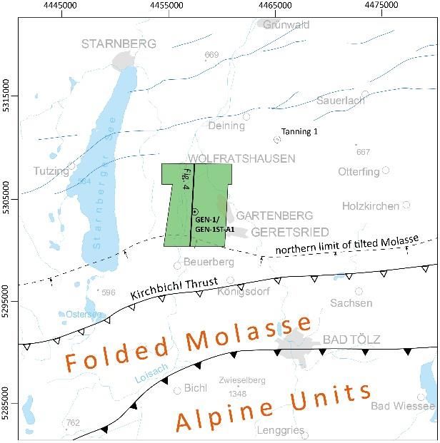
Shipilin et al.

Figure 4: N–S seismic profile through the study area (for location, see Fig. 1), showing three phases of faulting:
        (1) Jurassic–Cretaceous extensional faulting; (2) Oligocene extensional faulting; (3) Middle Miocene
                                               contractional faulting.

The timing of the faulting activity correlates well with     from Mesozoic strata during the Chattian faulting event
the separation of the Middle Penninic microcontinent         was probably arrested by the intermediate 600 to 900 m
from Europe at the Jurassic–Cretaceous boundary              thick, mechanically incompetent Rupelian clayey
(Frisch, 1979).                                              marls, in which displacement was accommodated by
                                                             ductile deformation. This resulted in zones of
The later phase of active continental collision and          mechanical weakening from which faults could initiate
subsequent flexure of the European lithosphere               in the overlying, more competent Baustein beds.
triggered extensional faulting in the German Molasse
Basin (Bachmann and Müller, 1992). In our study area,
this phase is expressed by two intermittent faulting
events; reactivation of the pre-Alpine faults, up to the
top of the Priabonian strata in the Rupelian, and
formation of new normal faults within the Baustein
beds in the Chattian (Fig. 4). The relative timing of the
faulting events were determined based on the fault
throw analysis and thickness maps of the Rupelian and
Chattian sequences. The Rupelian thickness map in
Figure 7 shows thickness increase above graben
structures and hanging walls of the reactivated pre-
Alpine faults. This is indicative of the syn-depositional
activity of these faults in the earliest Rupelian. The
faults in the Baustein Beds must have developed after
these beds were deposited, since they show relatively
uniform thickness across faults and therefore were
active during the accumulation of the overlaying
Chattian Sands. The period of quiescence in faulting
activity between the earliest Rupelian and the Chattian
suggests a temporal decrease of subsidence in this area.

We postulate that, despite the absence of hard coupling      Figure 5: Map of fault traces picked within the 3D
between the reactivated pre-Alpine faults and the faults       seismic volume. Faults in the Tertiary Molasse
in the Baustein beds, the former pre-determined the          (orange lines) and faults in the carbonate platform
locations of later faults. The up-dip fault propagation          (blue lines) have the same strike direction.
                                                                                                                    5
Shipilin et al.

    Figure 6: Along-strike projection of the throw of
                  Gartenberg_N fault.                        Figure 7: Isochore map of the Rupelian sequence.
                                                             Dashed lines are the projections of the faults from
As the Alpine thrusts propagated north, the extensional         below to show how the sediment thickness is
deformation at Geretsried was succeeded by                          controlled by the fault distribution.
contraction. The foreland-flexure extensional faults
within the Baustein beds were preferentially oriented        However, the overlying mechanically weak Rupelian
within the active stress field, thus allowing reactivation   clayey marls impeded the later up-dip propagation of
as reverse faults. In the southern part of our study area,   the faults further into the Tertiary Molasse. This might
we interpret an extensive thrust fault (the Geretsried       have prevented widening of the fault damage zone and
Thrust), which overprints the normal faults. A               the connected overall increase of fault conductivity.
prominent stepover along the Geretsried Thrust is
                                                             The occurrence of contractional deformation in the
observed within a linkage zone between two normal
                                                             Tertiary Molasse indicates high horizontal stresses in
faults (Fig. 4). Most probably the Geretsried Thrust
                                                             this region at the moment. Such an observation leads to
branched off the Subalpine thrusts and propagated as a
                                                             the conclusion that the longitudinal faults should be
décollement within the Rupelian Clayey Marl until it
                                                             experiencing high normal stresses and might be
encountered a zone of weakness in the form of pre-
                                                             compressively locked and therefore act as barriers to
existing normal faults, along which it ramped up into
                                                             fluid flow. This, however, contradicts the results of the
the Chattian sequence.
                                                             drilling of the Geretsried GEN-1ST-A1 well: within the
Directly above the Geretsried Thrust, the Neogene            seismically interpreted fault zone of the Gartenberg_N
sediments are tilted and dip northwards. According to        fault, there were total mud losses of ca. 215 m3. This
the tectonic map by Ortner et al. (2015), this could be      suggests that despite high normal stresses at Geretsried,
interpreted as footwall drag beneath the Kirchbichl          the stress regime within the carbonate platform is not
Thrust of the Subalpine Molasse 3-4 km to the south.         compressional, but due to the high vertical stresses at
However, we observe that the tilted strata flattens          4-5 km depth, it remains to be of normal or strike-slip
eastward, as the displacement along the Geretsried           faulting. Thus, to the best of our knowledge, the faults
Thrust decreases in the same direction. We therefore         remain conductive.
rather believe that the northward dipping strata formed
as the result of hanging-wall folding above the              6. CONCLUSIONS
Geretsried Thrust.                                           The present study shows that the various strata at
                                                             Geretsried have undergone different deformation
5. IMPLICATIONS FOR GEOTHERMAL                               phases; extension in the pre- and early-orogenic stages
RESERVOIR UTILIZATION                                        of basin formation and contraction in Miocene times.
Results of the seismic interpretation and kinematic          The southern part of the German Molasse Basin is
analysis show that the Upper Jurassic carbonate              characterized by decoupled deformation, due to the
reservoir of the Geretsried area is controlled by organic    southward thickness increase of the Rupelian clayey
build-ups and isolated, longitudinal normal faults.          marls. We emphasize the importance of detailed
Having initially formed during passive margin                structural analysis for reservoir characterization of deep
extension in the Cretaceous, they were then reactivated      geothermal aquifers in the Molasse Basin. The
in the Rupelian during the foreland flexuring.               identified structures and deformation style indicate the

6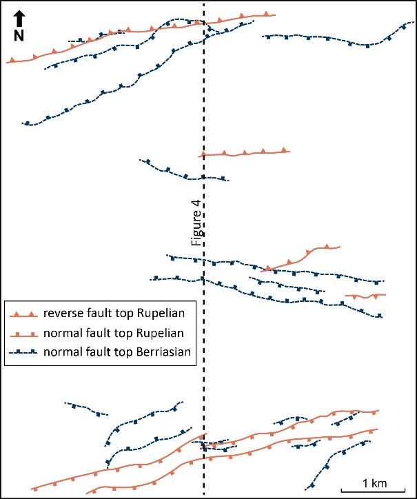
Shipilin et al.

active stress regime and thus provide insight into the   Moeck, I.: Catalog of geothermal play types based
hydraulic transmissivity of the fault zones.             on geologic controls, Renewable and Sustainable
                                                         Energy Reviews, 37, 2014, 867-882.
REFERENCES
                                                         Müller, M., F. Nieberding, and A. Wanninger:
Allan, U. S.: Model for hydrocarbon migration            Tectonic style and pressure distribution at the
and entrapment within faulted structures, AAPG           northern margin of the Alps between Lake
Bull, 73, 1989, 803–811.                                 Constance and the Rivver Inn, Geol. Rundsch.,
Allen, P.A., Crampton, S.L., Sinclair, H.D.: The         77(3), 1988, 787–796.
inception and early evolution of the North Alpine        Ortner, H., S. Aichholzer, M. Zerlauth, R. Pilser,
Foreland Basin, Switzerland. Basin Res. 3, 1991,         and B. Fügenschuh: Geometry, amount, and
143-163.                                                 sequence of thrusting in the Subalpine Molasse of
Bachmann, G. H., G. Dohr, and M. Müller:                 western Austria and southern Germany, European
Exploration in a classic thrust belt and its foreland,   Alps, Tectonics, 34, 2015, 1–30.
Bavarian Alps, Germany, AAPG Bulletin, 66(12),           Pfiffner, O. A.: Tectonic evolution of Europe -
1982, 2529–2542.                                         Alpine Orogeny. In: Blundell, D., Freeman, R. &
Bachmann, G. H., M. Müller, and K. Weggen:               Mueller, S. (eds.) A Continent Revealed: The
Evolution of the Molasse basin (Germany,                 Eropean     Geotraverse.     Cambridge,     U.K.:
Switzerland), Tectonophysics, 137, 1987, 77–92.          University Press Cambridge, 1992.
Bachmann, G. H. and M. Müller: Sedimentary and           Reinecker, J., M. Tingay, B. Müller, and O.
structural evolution of the German Molasse Basin,        Heidbach: Present-day stress orientation in the
Eclogae Geologicae Helvetiae, 85, 1992, 519–             Molasse Basin, Tectonophysics, 482, 2010, 129–
530.                                                     138.
Budach, I., I. Moeck, E. Lüschen, and M.                 Schulz, R., R. Thomas, R. Jung, and R.
Wolfgramm: Temporal evolution of fault systems           Schellschmidt: Geoscientific prospect evaluation
in the Upper Jurassic of the Central German              for the Unterhaching geothermal power plant, Z.
Molasse Basin: case study Unterhaching, Int J            Angew. Geol., 50(2), 2004, 28–36.
Earth Sci (Geol Rundsch), 107, 2017, 635–654.            Sissingh, W.: Tectonostratigraphy of the North
Diem, B.: Die Untere Meeresmolasse zwischen              Alpine Foreland Basin: correlation of Tertiary
Saane (Westschweiz) und der Ammer                        depositional cycles and orogenic phases:
(Oberbayern): Ecl. Geol. Helv., v. 79, 1986, p. 493      Tectonophysics, v. 282, 1997, p. 223-256.
– 559.                                                   Tavani, S., F. Storti, O. Lacombe, A. Corradetti, J.
Eisbacher, G.: Molasse – Alpine and Columbian:           A. Muñoze, and S. Mazzoli: A review of
Geoscience Canada, v. 1, 1974, p. 47-50.                 deformation pattern templates in foreland basin
                                                         systems and fold-and-thrust belts: Implications for
Frish, W.: Tectonic progradation and plate
                                                         the state of stress in the frontal regions of thrust
tectonic evolution of the Alps: Tectonophysics, v.
                                                         wedges, Earth-Science Reviews, 141, 2015, 82–
69, 1979 p. 121-139.
                                                         104.
Lemcke, K.: Zur nachpermischen Geschichte des
                                                         von Hagke, C., Lujiendjik, E., Ondrak, R.,
nördlichen Alpenvorlandes: Geologica Bavarica
                                                         Lindow, J.: Quantifying erosion rates in the
69, 1973, p. 5-48.
                                                         Molasse basin using a high resolution data set and
Lemcke, K.: Geologie von Bayern; I, Das                  a new thermal model. Geotect. Res. 97, 2012, 94–
bayerische Alpenvorland vor der Eiszeit:                 97.
Stuttgart,         E.         Schweizerbart’sche
                                                         von Hartmann H., D. C. Tanner, and S.
Verlagsbuchhandlung, 1988, 175 p.
                                                         Schumacher: Initiation and development of
Lüschen, E., M. Dussel, R. Thomas, and R.                normal faults within the German alpine foreland
Schulz: 3D seismic survey for geothermal                 basin: The inconspicuous role of basement
exploration at Unterhaching, Munich, Germany,            structures, AGU Tectonics, 35, 2016, 1560–1574.
First Break, 29(1), 2011, 45–54.
                                                         Weides, S., and J. Majorowicz: Implications of
Meyer, R. K. F., and H. Schmidt-Kaler:                   spatial variability in heat flow for geothermal
Paläogeographischer Atlas des Süddeutschen               resource evaluation in large foreland basins: the
Oberjura (Malm), Geol. Jahrb., Reihe A: Allg. und        case of the Western Canada Sedimentary Basin,
Reg. Geol. BR Dtschl. und Nachbargebiete, 115,           Energies, 7(4), 2014, 2573–2594.
1990, 77 pp., Fed. Inst. for Geosci. and Nat.
Resour., Hannover, Germany.
                                                                                                              7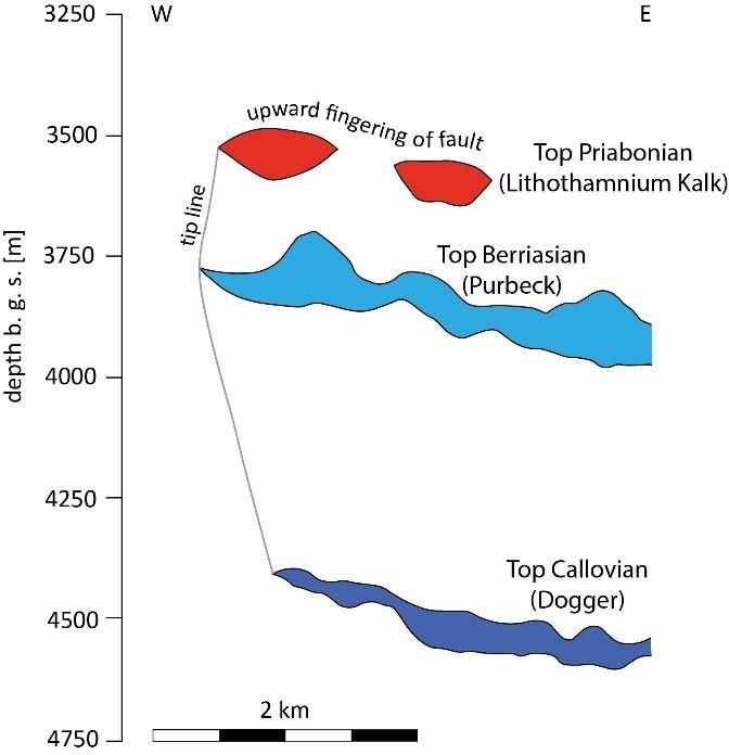
Shipilin et al.

Ziegler, P. A.: Geological Atlas of Western and
Central Europe: The Hague, Shell Internationale
Petroleum Maatschappij, B.V., 1990, 239 p.
Ziegler, P. A., Cloetingh, S. & van Wees, J.-D:
Dynamics      of    intra-plate   compressional
deformation: the Alpine foreland and other
examples. Tectonophysics, 252, 1995, 7–59.
Zweigel, J., 1998, Eustatic versus tectonic control
on foreland basin fill. Sequence stratigraphy,
subsidence analysis, stratigraphic modelling, and
reservoir modelling applied to the German
Molasse Basin: Contr. Sedimen. Geol, Stuttgart,
E. Schweizerbart’sche Verlagsbuchhandlung, v.
20, 1998, 140 p.

8
You can also read