Farming System Transformation Impacts on Landscape: A Case Study on Quality Wine Production in a Highly Contested Agricultural Landscape - MDPI
←
→
Page content transcription
If your browser does not render page correctly, please read the page content below
land
Article
Farming System Transformation Impacts on
Landscape: A Case Study on Quality Wine Production
in a Highly Contested Agricultural Landscape
George Vlahos
    Department of Agricultural Economics and Rural Development, School of Applied Economics and
    Social Sciences, Agricultural University of Athens, 11855 Athens, Greece; gvlahos@aua.gr

    Received: 9 March 2020; Accepted: 14 April 2020; Published: 17 April 2020

    Abstract: This paper is an attempt to synthesize the conclusions of a series of consecutive research
    projects along a common thread. It focuses on the landscape impacts of a gradual transformation
    undergone by a low input and bulk wine producing system into a quality wine system. This
    transformation took place on the island of Santorini, in Cyclades, Greece, during the last four decades
    in a highly contested landscape. A polarization in the power game has been identified, with two
    poles having different priorities and perceptions about the two issues at stake: agricultural landscape
    and wine quality. In the course of this process, both synergistic and antagonistic transition dynamics
    are encountered, transforming significantly the balance of driving forces. Our analysis suggests that
    market forces influenced landscape change to a far greater degree than policy measures implemented
    on the island. Developments in the international markets for tourism and quality wine have played
    a crucial role in land use change and farming intensity. Public intervention in the form of both
    regulatory land use planning policy and incentive measures like Rural Development Policy, including
    an agri-environmental measure, targeted to the vineyards of Santorini, did not seem to have an
    equally important impact. Integration of landscape maintenance practices within the wine quality
    regime could create beneficial synergies.

    Keywords: landscape dynamics; driving forces; transition; quality wines; Santorini; Greece

1. Introduction
      Various challenges and changes in agri-food systems have been increasingly analyzed through
the ‘transition to sustainability’ perspective over the last two decades1 [2,3]. Geographical diffusion of
production and dependence on the natural environment (space and resources), along with the use
of diverse technologies instead of a dominant technology, are some of the features that differentiate
transitions in the agri-food sector from transitions in other domains [4].
      Transformation processes, when the level of study is appropriate, could be reflected in specific
landscape changes, especially when they involve changes in land use and intensity management
practices [5–10].

1     Part of the information used in this paper was collected during the course of the project FARMPATH- Farming Transitions:
      Pathways towards regional sustainability of agriculture in Europe, a project co-funded under the European Union’s Seventh
      Framework Programme for research, technological development and demonstration GA 265394. This information was used
      in a previous paper by Vlahos et al. [1] presented during the 12th International Farming Systems Association Symposium.
      Furthermore, information and data has been drawn from the project ENVIEVAL—Development and application of new
      methodological frameworks for the evaluation of environmental impacts of rural development programmes in the EU, a
      project co-funded under the European Union’s Seventh Framework Programme for research, technological development
      and demonstration GA312071.

Land 2020, 9, 120; doi:10.3390/land9040120                                                       www.mdpi.com/journal/land
Land 2020, 9, 120                                                                                    2 of 19

      In systematic reviews on landscape changes, the driving forces behind them have been
distinguished between proximate and underlying driving forces. Proximate driving forces arise
through human actions at the local level, while underlying forces are characterized by scholars as those
that reflect global trends in either the sociocultural, political, or economic domains, or global changes
in natural conditions [11–15].
      A distinction between conversions of land use and changes in land management intensity could
be functional, since one can encounter both phenomena in the case under study. Jepsen et al. [16]
suggest that land management intensity (e.g., input use, productivity increase) has not drawn enough
attention in the literature, partly attributing this relatively lesser attention to lack of spatial data.
Even in the cases where land use intensification has been the focus, this was limited to studying the
expansion of cash crops and irrigation, leading to a simplification of landscape and loss of genetic,
species, and ecosystem biodiversity [15,17,18]. The special case of vineyards, when dealing with the
effects of agricultural land use changes on landscapes, is very well documented. Vineyards constitute
an iconic case of cultural landscapes, denoting terroir as a hybrid notion incorporating physical and
human dimensions [19]. They also have an additional quasi-public good attribute that local actors may
possibly individually exploit, in a healthy competition, namely, the reputation of locally produced
wines [20].
      Santorini ranks, in most tourism-related websites, within the world top-10 lists of island touristic
destinations, having established strong links with international tourism markets. Tourism on this
island nurtures a series of conflictual and co-operative relationships with other sectors and domains,
especially agriculture, with clear repercussions on its valuable but fragile landscape. The role of tourism
as a driving force for land use change has been studied extensively. Using a complex adaptive system
perspective, development in tourism destinations can be understood as a multilevel, co-evolutionary
process, involving diversification in touristic products, which requires, inter alia, networking activities
among actors and various niche-innovations [21]. Therefore, this approach, integrating the tourist
character of the island as a driving force, could prove quite useful in the case of Santorini, especially
when the creation of a touristic niche market acquires a pivotal role, in order to understand landscape
dynamics [22].
      Lambin and Mayfroidt [6] suggest that “land use change is non-linear and is associated with other
societal and biophysical system changes”. In order to comprehend the mechanisms of land use change
and analyze the interplay between actors, driving forces, and landscape, the typology of approaches
suggested by Herspberger et al. [23] is very useful. The approach selected has been the one where
actors are placed in the center of the analysis. In that approach driving forces “are complemented
by individual factors, such as knowledge, experiences, and belief systems, all playing a part in the
decision making process” [24].
      On the other hand, quality in wine production is the focal point of a major restructuring process
of the whole wine sector, around which a confrontation takes place, on the basis of the application and
re-interpretation of different quality contents. After the 1980s, a series of novel technologies evolved in
the wine industry, such as innovative wine equipment, biotechnology applied to yeasts, biosensors,
and alternative wine making techniques [25]. Additionally, Cusmano et al. [26] have stressed the
positive role played by the institutional framework in influencing producers’ innovation in New World
wine countries.
      Deliberate efforts for the development of a quality wine sector in Greece date back to the early
1960s. An initial system of labeling was introduced in 1970s, while after Greece’s accession into the
European Union (EU) in 1981, quality in the wine sector was promoted within the overall European
regulatory framework. More recently, the Greek wine sector has been characterized by declining
trends of overall production and a coinciding shift towards quality upgrading. Total wine production
decreased by 23% between the 2004–2009 and 2010–2015 periods (i.e., before and during the severe
crisis endured by the Greek economy during the second decade of the 21st century). During the same
period, the volume of quality wines increased by 83.2%, while the production of wines without any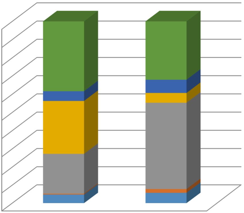
Land 2020, 9, 120                                                                                  3 of 19

quality certification declined by 36.4%. Consequently, the share of all quality wines has more than
doubled, from 11.3% to 26.8% [27].
     The wines of Santorini Island, in the Cyclades, have been an important part of the attempt of
Greek winemakers to enter the global market for quality wines. Twenty-five indigenous grape varieties,
adapted to the hot-dry climate, harsh winds, and volcanic soils, are grown on the island. In addition,
Santorini remains one of the few places in Europe with its original ungrafted vines, as the volcanic
geology made its grape varieties immune to phylloxera [28]. Two farming practices, manifestations
of the adaptation to local environmental circumstances, constitute crucial elements for the landscape
of the island. The first is the self-propagation of vines, which makes mechanization and the use of
equipment almost impossible. The second practice concerns two pruning methods, which are the
result of a long process of adaptation to locally specific climatic features i.e., strong winds and dry
weather conditions during the summer. Nevertheless, they still reduce productivity, require skilled
labor (pruners), and, consequently, increase production costs. As far as the market outlets for wine are
concerned, up to the last decades of the 20th century, the wine produced was sold, mainly in the form
of bulk, to the nearby islands as well as to the mainland, through informal networks of out-migrants
to urban areas in Greece (mainly Athens, the capital and largest urban conurbation of Greece and its
port, Piraeus). The local co-operative could afford the only sizeable bottling unit and an elementary
marketing mechanism.
     High quality wine production aiming at the global market has become, during the period examined,
an integral part of the local production system. In the course of this process, a series of innovations
have been introduced and established, including the use of new technological and biological means,
as well as changes in specific farming practices. The importance of these changes is that they have a
direct impact on the landscape since they concern the very practices that have shaped the agricultural
landscape of the island for ages.
     This study aims at analyzing the landscape effects of a transition of an agri-food system at the
sub-regional scale during the last four decades. More specifically, the study aims to explore the
transformation undergone by the agri-food system, as well as the interplay of driving forces and actors
and the dynamics developed in the course of this transition. The particularity of the specific case is
that the changes, transformations, and the driving forces involved have been reflected in land cover
and land use intensity, as well as landscape features. The empirical part of the study was based on
material mainly collected in the context of co-funded research projects, as well as on previous and
continuous follow-up research by the author in the same area.

2. Materials and Methods
      As mentioned above, the current paper is an attempt to integrate along a common thread the
results of various projects. The scope of these projects has been the study of the evolution of the
system around the Santorini vineyard during the last 4 decades. Emphasis in this paper was given to
depicting the way this process, through various stages, has been reflected in the agricultural landscape.
A distinction between broad land use change and land management intensity was considered necessary
in order to better identify driving forces behind the transition. In the specific case two changes
have been considered as resulting to an intensification of production practices: first, homogenization
since only one variety was planted on the same land parcel and, second, the installation of linear
supporting systems and the consequent change of pruning system, which drastically changed the
landscape. During the course of these years a multiplicity of methods has been employed to analyze
the transformation of the previously existing system producing bulk wine to a system oriented towards
the production of quality wine and the impacts of the transition on the landscape of Santorini.
      Desk research has been conducted continuously since 2007, drawing information from press
releases, articles in newspapers, and printed and electronic reviews, specializing in both wine and
agricultural issues, as well as official legislative and administrative documents.
Land 2020, 9, 120 4 of 19
The field research, within the context of the FARMPATH project (Farming Transitions: Pathways
towards regional sustainability of agriculture in Europe), consisted of empirical material collection
through open interviews. The field research was preceded by a review of the agri-food sector of
Santorini, through which an initial draft of a stakeholder map was created. The interviews were
conducted during the spring of 2012, and the first draft was modified with the contributions of
the interviewees.
Finally, the following local stakeholders were interviewed:
• three farmers;
• two executives from the Union of Agricultural co-operatives;
• an extension officer;
• a private agronomist/oenologist employed in wine-tourism;
• eight winemakers.
During the field research, an aide memoire was used as a guide focusing on the transition process
that occurred on the island. Respondents were asked to give their narrative for the development of
the transition. They were asked to refer with considerable detail to technical and practical, as well as
economic, aspects of the process examined. Particular emphasis was placed on analyzing the existing
networks and their evolution during the course of the process. Policy measures relevant to the area
and the wine sector, either supportive to the transition or acting as obstacles, formed the basis for the
next set of questions and the discussion was complimented with specific reference to young farmers
and new entrants in agriculture. The structure of the aide memoire and hence the interviews was
common across all case studies of the FARMPATH project (see Supplementary Document). In the
case of Santorini vineyard, the initiative analyzed was the attempt to explore alternative marketing
channels for local products [29].
In addition to the above, expert interviews in Athens were conducted with a winemaker, a Rural
Development Policy Management authority staff member, and two academics. All interviews were
taped and transcribed. Interview transcripts were analyzed for the purpose of this paper under the
light of land use and management practice changes and/or maintenance as outcomes of this dynamic
process of interaction between driving forces and actors since these changes are directly reflected in
the landscape [30,31].
A third category of data, concerning landscape changes and policy implementation, was gathered
during the spring of 2015, in order to examine the impacts of agri-environmental and rural development
policies on the landscape, in the course of the ENVIEVAL project (Development and application of
new methodological frameworks for the evaluation of environmental impacts of rural development
programmes in the EU). This information comprised land cover data of the northern part of Santorini
drawn from satellite images (8 June 2003 and 8 July 2012), downloaded from Google Earth (GE) [32]. A
geodatabase, with two land cover maps for 2003 and 2012, was created after a photo interpretation and
digitization of the images acquired. The interpretation resulted in six land cover types as follows:
1. Traditional vineyards: vines grown in a disorderly manner at a distance of 2 to 2.5 m, scattered at
quasi-random locations and pruned with the traditional techniques of ‘giristi’ or ‘kouloura’;
2. Linear vineyards: vines trained horizontally along wires, subdivided into two classes in relation
to their planting density:
2a. high density
2b. lower density;
3. Other cultivated land: including all other crop types;
4. Bare land: mainly rocky areas without vegetative coverage;
5. Built-up area.Land 2020, 9, 120 5 of 19
Reif et al. [33] argue that it is mandatory to have sufficient ground truth data in order to increase
reliability. Hence, after the initial classification, a ground truth survey was conducted. Thus, ambiguous
features of the image interpretation were used as sampling points for direct observation. After correcting
the interpretation mistakes, the preliminary classification of the land cover maps was adjusted and the
following land cover classes were determined:
1. traditional vineyards;
2. linear vineyards;
3. area under annual crops;
4. other cultivated area;
5. bare land;
6. built-up area.
3. Results
3.1. Underlying Driving Forces for the Transition
In the case of Santorini Island, three different driving forces can be identified as exerting an
important influence on agriculture, land use, and, hence, the landscape. Two of these, namely, the
trends of international markets of tourism and quality wines, can be characterized as underlying.
On the other hand, one can also identify a set of proximate driving forces, such as policies that have
greatly influenced land use and farming practices. The policy measures that have seemed to acquire
particular importance are the Common environmental policy, the Common Agricultural (and Rural
Development) Policy at the EU level, and spatial planning policy at the national/regional level.
During the timeframe of this paper, the last four decades, there have been various developments
that have affected tourism in the island. Firstly, global changes, such as improved transport
infrastructure and lifestyle changes, have boosted tourism development. The first wave of tourism
development emerged on the island during the early 1980s and mainly affected space and labor, two
elements highly contested locally by both farming and tourism. The number of beds offered to tourists
in Santorini increased from 8968 in 2002 to 11,955 in 2012 [34]. Land on the islands has always been a
scarce resource and, in the Greek islands in particular, where land tenure is characterized by small
allotment size and high fragmentation. Increased demand for land for the construction of hotels and
other tourism or commercial enterprises resulted in a considerable increase of land prices, including the
price of agricultural land. At the same time, attractive salaries were offered to the local labor force in
both tourism and construction, therefore absorbing latent unemployment and reducing out-migration.
During the 2000s, however, global changes seem to have had impacts on both the local land
and labor market. Within the process of expansion and growth of the tourism industry worldwide,
a saturation of certain market segments caused the emergence of strong trends towards the provision
of differentiated and diversified tourism services. New forms, such as ecotourism, cruises, wine
tourism, or combinations of these, emerged during the 1990s and gained impetus [35]. Big hotels and
mega-installations were not sought after any more, hence, demand for land became selective, and even
smaller parcels of land acquired increased value. At the same time, the agricultural landscape was
qualified as an asset for tourism along with the volcanic landscape and the seascape/view.
On the other hand, another global driving force that affected both the local tourist industry, as
well as farming on the island, has been the development of a worldwide market for quality wines in
which globalization is manifested through a strong tendency towards homogenization of the taste and
the creation of ‘international wines’ [35,36]. The market for quality wines appears to have expanded
rapidly during recent decades, as can be seen by sales and exports data. Thus, various changes occurred
in order to facilitate a new way of co-ordination of the wine value chain actors in order to deal with
the various external threats or opportunities concerning wine production [37]. Finally, the globally
widespread perception of ‘localness’ and provenance as an element of quality, especially for wine,
has been a further factor that seems to have played an important role in the changes that occurredLand 2020, 9, 120 6 of 19
in Santorini wineries. There are quite a few elements that suggest that geographical indications (GI)
provide a considerable value added to wine, e.g., a price differentiation for GI wines [38].
3.2. Agriculture—Tourism Synergies and Conflicts in Santorini
The two interconnected systems, tourism and agri-food (mainly wine production), can be better
described by analyzing the synergies and conflicts created during their co-evolution during previous
decades. Santorini has been known for its wine production and trade since the ancient times. Almost 100
years ago (1920), vineyards covered 3500 ha, accounting for 84% of the cultivated land [39]. A gradual
decline over the years was accelerated by a massive earthquake in 1956 (2250 ha in 1970), followed by the
augmentation of tourism in the 1980s resulting in a further decrease to 1492 ha in 1997 [40]. Since then,
the area covered by vineyards seems to have stabilized and, according to data in 2012, it covered 1285
ha with wine production reaching 3151 tons [41]. More recent research suggests a reversal of this trend,
i.e., an increase of the area under vineyards, at least on the northern part of the island [42].
During the early 1980s, Santorini was increasingly valued as an attractive tourism destination.
The process followed a pattern common in Greece: a disorderly establishment of small size tourist
installations, starting from the littoral and gradually expanding to other areas. The view, volcano,
sunset, beach, and nightlife were the main (if not the only) features of the Santorini tourism industry.
There were no strong linkages established with other local agricultural products other than wine,
although there were a number that could be promoted, such as small tomatoes, white eggplant, fava,
a puree made of Lathyrus spp., etc.
The numerous touristic activities, despite their small size, increased pressures on agricultural land
uses. In addition, an equally important impact was the increased option-cost of labor, especially for the
local youth. Adopting a strategy based on flexibility, households divided their available labor, with older
members dealing with the vineyards and the younger occupied in construction and tourism. The latter
were, nevertheless, always available during the peak of agricultural activities, particularly the harvest.
The small size of businesses in both regimes permitted the smooth flow of labor between the two activities.
The adaptive strategies that followed did not mitigate the impacts on agricultural land use and
the local labor market. On the contrary, they continued to result in an impressive sprawl of urban uses
and increased land prices, with detrimental effects on the rural and the volcanic landscapes, as well as
on the built environment of the island. Gradually, the flourishing tourism businesses attracted further
external investment, as well as real estate. Cheaper external labor became also available on the island,
thus creating increased competition for local labor.
3.3. The Reconfiguration Process
During the 1980s, one of the largest wine-making companies, based in Northern Greece, started
its first attempts towards quality wine production in Santorini. The firm followed the international
trend of linking wine with tourism, in collaboration with local bulk wine producers and a co-operative
(‘Santo Wines’) [43]. At the same time, they experimented with traditional techniques used in the
area such as the re-utilization of ‘canavas’, i.e., human-made grottos used for the aging of the wine.
This decision seemed to have been influenced by four factors: a generational change within the
company; the availability of new technological innovations, especially for the processing of the grapes;
associated funding through investment subsidies; and finally, the coincidence with the increase in
arrivals of tourists on the island. Acting synergistically, these factors seem to have triggered the gradual
transformation of the agri-food regime, starting in 1989, with the establishment by the company of
a modern winery and an information center in which visitors could taste and purchase wine [44].
Later (1992), the local co-operative, comprising 2500 farmers, created an independent facility with
considerable success, while in 1998 and 2005, under the EU’s support schemes, the co-operative
modernized its winery and improved its winemaking capacity [Co-op exec, 44]. In this respect, two
established actors played a crucial role in the initiation of the process of change: they offered legitimate
power and resources as well as considerable momentum to this process [45].Land 2020, 9, 120 7 of 19
These two efforts, apart from being two successful initiatives, paved the way for a new wave
of winemakers, who were mainly younger people with origins on the island, who up to 1980s were
migrating for studies or/and work. These returning ‘new entrants in agriculture’, according to the
winemakers interviewed, came to the island having already established professional, personal and
political, as well as social, networks acquired during their previous occupations. Apart from contacts,
new wine-makers had a vision for their business and local wine. All winemakers interviewed inherited
their land; three came from families which traditionally produced and/or traded with wine and some
inherited installations and equipment. All winemakers hired specialized oenologists, while one of the
interviewees, apart from digging a new ‘canava’, also hired an expert who had studied in France and,
during her career prior to Santorini, worked in California, Australia, and another quality wine making
area in Northern Greece. All the above suggest that the new winemakers displayed a high degree of
persistence in quality improvement.
Substantial co-ordination efforts of individual winemakers can be identified in their joint
presentations to international fares and exhibitions and participation in contests, as well as in
establishing linkages to mainstream and influential specialized press in both Greece and internationally.
Another attempt towards horizontal co-ordination was the ‘voluntary commitment contract’ that all
wineries of the island signed with the National Inter-Professional Organization of Vine and Wine,
whereby they are bound to protect the fame of the wine and, at the same time, avoid unfair competition
practices. Therefore, apart from the multiplication of involved actors, new networks have been created
and a remarkable networking activity has taken place.
In parallel with the above developments in the local wine institutional and market arrangements,
the global trend towards alternative forms of tourism highlighted the environment and ‘localness’ as
important elements of diversification of the tourism product [35,46]. Taking these developments into
account, diversification of tourism services locally seemed inevitable. According to estimations of local
stakeholders, urban settlements of Santorini, mainly Fira and Oia, during the summer period receive
an average of 14,000 visitors daily [47]. The ‘saturation’ of the conventional local touristic market
was, nevertheless, perceived by the Santorini wineries as an opportunity for synergies. Currently,
there are 13 wineries offering wine-touristic services as well as direct sales. Wine tours are offered
to tourists during the entire touristic period, some by specialized agencies (Agronomist/Oenologist).
Thus, the introduction of novel practices and the transformation of the agri-food regime contributed
to the creation of strong inter-regime links. The importance of this shift to wine tourism has been
reflected in the landscape, through the establishment of new linear vineyards, as shall be shown below.
3.4. Proximate Driving Forces: The Key Role of Public Intervention
3.4.1. Policy Measures Promoting Wine Quality
The island of Santorini was one of the first places in which the Greek state tried to design and
implement policy measures to promote quality wines. The first ‘Indication of Origin’ for Santorini’s
wines was legislated by the European Economic Community (EEC) in 1970 as a result of a Greek
request, based on the findings of a number of oenological studies, conducted by the Greek Ministry
of Agriculture in 1962, concerning the ecosystem of the island and three native vine varietals [28].
The next decisive step was taken in 1981—when Greece accessed the EEC—with a Santorini wine
designated as ‘Vin de Qualité Produit Dans Une Région Déterminée’ (VQPRD) in the EEC market,
following requests of the Greek state. Currently, there are three types of wine produced on the island
that are registered as wines of Protected Designation of Origin (PDO).
A second policy measure has been the support of investments provided by national and EU
funds. Technological innovations in wine making have been available since the late 1970s [48]. The
support provided made possible access of wine makers to these innovative techniques by significantly
contributing to investment costs. Otherwise, the small size of vineyards in Santorini would render theLand 2020, 9, 120 8 of 19
quest for investment capital for novel techniques and equipment in wine making a rather difficult exercise,
especially since it concerns small specialized businesses, with limited possibilities for expansion in size.
3.4.2. Policies Affecting Land Use and Intensity of Farming
Within the EU rural development policy framework, two policy measures providing incentives
to farmers have been implemented during the last two decades. The former, beginning in the 1990s,
concerns the support of farming in small islands of the Aegean Sea. Farming on islands is considered
of great importance for the maintenance of the social fabric, as well as the traditional Aegean landscape.
Acknowledging, hence, the accessibility problems, as well as increased production and marketing costs
of agriculture in the islands, the EU provides financial support to farmers. Within this specific policy
measure, a scheme for the maintenance of traditional crops cultivated on the islands was launched.
Vineyards as well as a number of other traditional crops of Santorini are included in the list of the crops
supported. Almost the totality of active farmers on the island received this support [49]. Another
targeted agri-environmental measure is aimed at the maintenance of the traditional agricultural
landscape of Santorini. Farmers under this scheme are compensated in order to continue pruning and
propagating the vines using the traditional and costly techniques as well as to leave uncultivated area
in each parcel. More than half of the island’s area and farmers participate in this measure. Both these
measures seem to have been clear successes, in terms of their acceptance by farmers [50].
A draft Spatial Plan for the whole island, including the agricultural landscape of Santorini, was
prepared and proposed in 1998, as part of the national spatial planning policy. It was evaluated by
planners as a complete and structured proposal for a comprehensive land use plan, placing restrictions
and designating protected areas [34,51]. The draft plan also received vociferous support by all actors
and was met with the unanimous approval of all interviewed stakeholders. However, it is not,
yet, legally binding since its formal approval and ratification has remained pending since 1998. Another
attempt to regulate land use on the island was made in the early 1990s with an ad-hoc ‘Plan for
the determination of zones for settlement development control of Santorini’. This targeted the most
vulnerable zones of the volcanic landscape and archaeological sites. However, this attempt has not
been successful in restricting unplanned construction. It created distortions in land market value,
hence, it was complemented in 2011 with a Ministerial Decree which temporarily suspended building
permits. It was again supplemented, a year later, by a law allowing only authorized repairs and
restoration. Further land use control measures, such as the General Urban Plan in 1987 and the Town
Plan Study for Fira in 1991 have been limited to the urban environment around the main settlement
of the island [34]. Finally, all efforts undertaken by the Ministry of Rural Development and Food to
protect either highly productive land or areas characterized as having high natural value and/or areas
constituting important agricultural landscapes, have remained at the stage of statements of principles
and noble intentions.
The actual landscape impacts of these policy measures cannot be disentangled from those resulting
from the significant pressures exerted on land uses by tourism and housing. Thus, the statement by
Lambin and Mayfroidt on the multifaceted nature of land use change dynamics [6], as well as the
doubts raised Freshwater [52] on the effectiveness of rural development and/or agricultural policies
against urban sprawl, have been corroborated. All public policy interventions and rural development,
agri-environmental, and spatial planning measures, have not appeared to be effective, especially in the
areas where urban pressures have been intense. Census data (1971 to 2011) suggest that the number of
buildings in Santorini has increased from 3755 to 13,528, resulting in 11% of the island’s land being
sealed by construction [51]
3.5. The Interplay between Factors and Underlying Driving Forces
The main conflict between tourism and agri-food regimes has been over land use, a conflict
that actually epitomizes frictions among the regimes and the outcome of which largely defined the
landscape of the island. As shown, tourism has been a fierce competitor over land use [34]. TheLand 2020, 9, 120 9 of 19
changes of the landscape of the island have been dramatic. The detrimental impacts have not been
limited to agricultural landscape. Urban continua have been formed, in serious detriment of both the
volcanic and vulnerable small-scale urban landscapes. The deceleration in the construction of hotels
and recreation facilities has been followed by a second wave of pressures, namely, that of summer
holiday luxury homes. Real estate investors took advantage of the deficient land planning system and
shifted their efforts towards luxury housing [34].
Within this land use conflict some important alliances have emerged between the co-operative and
the newly established private wineries, at least during the first phases of the transition. An informal
arrangement concerning the provision of raw material, i.e., grapes, paved the way for collaboration
among them. ‘Santo Wines’, the co-operative, was founded in 1947 as a mandatory co-operative,
in which membership of local grape-growers was obligatory by law. Nevertheless, as emphasized
by Iliopoulos and Theodorakopoulou [39] “while legislation permits Santo to demand that at least
25% of its members’ produce be delivered to the co-operative, Santo has silently conceded to accept a
lower percentage so that local private wineries can secure access to grape supplies, too”. A further
advancement of this collaborative arrangement between private initiatives and the co-operative took
place as a response to a policy measure, potentially detrimental for the island’s vineyard landscape.
As a part of the 2007 reform of the Common Market Organisation for wine, the grubbing up of vines
was promoted but the breadth of its implementation was left at the discretion of the Member State. A
co-ordinated effort of the Santorini Co-op, individual winemakers, and the local authorities, annulled
the application of this specific policy provision in Santorini by arguing that the traditional vineyard
and the landscape is a scarce economic and environmental resource that ought to be protected. This
arrangement was applied on an ad-hoc basis, but its success nonetheless emphasizes the potential of
more permanent forms of co-operation.
In terms of the interplay between actors and driving forces, it can be further observed that the
changing circumstances of international markets have acted as strong drivers that triggered inter-regime
frictions in the process of the agri-food regime transformation. Regarding the international wine
markets, two competing approaches have been observed. One aims at the homogenization of taste
and advocates for the prevalence of grape variety as a quality attribute. The other supports the value
of diversity of tastes and the importance of terroir, the latter conceived as “a unique combination of
environmental, agronomic and human factors, particular for each wine-producing area” [53,54]. Over
these two approaches, two distinct sociotechnical reconfigurations with the consequent institutional
arrangements have been formed in Santorini, having a notable effect on both agricultural production
process and the landscape.
In the context of the first approach and in order to comply with the new cultivation methods
required for the production of ‘international wines’ (since the mid-1990s), two farming practice changes
occurred. First, the need for land parcels to be planted with only one variety in order to better program
harvesting vs. the traditional way of mixing different grape varieties, which made it impossible to
co-ordinate harvesting even within one holding. This, however, meant that farmers should restructure
their vineyards investing resources and time, i.e., incurring an entry cost, in order to participate in the
quality production project. Second, early harvesting (middle to late August) is considered essential
for securing quality within the international approach. However, this created a serious conflict in
the intra-household division of labor, since the demand for labor in the vineyards coincided with the
peak of the touristic season. Traditionally, late harvesting (early–middle September), meant that the
members of the household occupied in tourism could also contribute to the task [49]. The already
conflictual relationship of the two regimes, i.e., tourism and agri-food, seemed thus to be further
aggravated. The possibility to establish a synergistic effect by using a contested resource, i.e., labor, in
different time periods, was precluded with the change of the agricultural calendar imposed by the
quest for quality [22].
The adoption of the first approach, the ‘internationalization’ of wine, calls also for the ‘correction’
of certain characteristics of the wines that are not ‘desirable’ by the actors that are important in theLand 2020, 9, 120 10 of 19
construction of the ‘ideal’ wine [21]. Thus, technical innovation was adopted by winemakers in the
processing part of the value chain. In the first place, their objective was to gain access to markets,
especially in the increasingly interesting and flourishing global quality wine market. When access to
the market was achieved, they strived towards maintaining their competitive edge through quality. In
that arena, the role of ‘terroir’ as a decisive factor of quality is not a fact as incontestable as one might
expect [55,56]. Especially in the case of quality wines, the debate on the issues of grape (variety) vs.
terroir, in other words on the uniformity of ‘international’ wines as opposed to the diversity of local
wines, is open and fierce [35,36,53–57].
Being in a relatively weaker position, farmers have to bear all the burdens of the abovementioned
changes in order to maintain access to outlets for their produce. The co-operative, functioning as
the last resort buyer for the grapes, can maintain prices at levels that favor farmers. The uneven
distribution of burden and the continuing pressure on prices at the farm gate cause a partial alienation
of grape producers from the ‘miracle of the Santorini vineyard’, the latter consisting of the worldwide
success of local wines.
In that complicated context, the interplay of underlying driving forces with local actors resulted
in a polarized system. The first of the two poles comprises the new innovative ‘international’ wineries,
which have as their main objective competitiveness and growth, are flexible and adjustable to the
changing demands of a very volatile market, and perceive the denomination of origin as merely
another element of their marketing strategy. Consequently, they try to force their providers, the
farmers, to adapt. They are fierce protectors of agricultural land use but also supporters of changes
deemed necessary in order to comply with standards, even if such changes have a detrimental effect
on the landscape and the environment in general. The issue here is that the changes in the pruning
practices and propagation methods affect the landscape that is so much valued, not only by experts
or environmentalists, but also by tourists. Landscape constitutes an essential part of the ‘Santorini
experience’, and is hence an asset for the island and the tourism regime. As a co-operative executive
stated: “[...]the way ........ [winemakers] are cultivating their vineyards is far from the local tradition,
since they use pesticides and, more than that, they destroy Santorini’s landscape by planting them
in linear supporting systems” [Co-op rep]. It is, however, argued by researchers that changes that
could have a negative impact on natural resources and/or the environment could also undermine the
long-term competitiveness of the wine in the global markets [58].
On the other pole lies the co-operative and its allies, the majority of the farmers, whose main
preoccupation is the viability of their households. The co-operative manages 60% of the local grape
production, which corresponds to 18,000 hectoliters of wine per year. The remaining 40% of the local
grape production is bought by local private wineries and then transformed into bottled wine. It has
to be noted that 70% of the co-operative’s production is destined for packaged/bottled wine while
the remaining 30% is sold in bulk [39]. This means that 18% of all grape production of the island
is still transformed as bulk wine. This, according to official protests of individual winemakers, is
considered as undermining the whole effort of the upgrading of Santorini wines. Thus, in the structure
of the local wine market there is a clear power asymmetry between the co-operative, which is the
price leader, and the private wineries that are price takers. The latter have to pay to grape growers a
25%–40% mark-up on the price set by Santo to ensure their supply in grapes [Wine maker]. That is
unquestionably reflected in the farmers’ sense of ownership for the Geographical Indication system. In
that sense, the fame of Santorini wine is perceived by farmers as a collective good. In addition to that,
pluriactivity is an important element of farmers’ survival strategy. Hence, tourism for them is not just
providing an outlet for their wine production but also constitutes an additional income source, either
through employment in or the establishment of tourism-related businesses; therefore, the agricultural
landscape is an essential asset for farmers as well.
It is worth mentioning that in such a ‘power landscape’, the role of institutions has been to a
certain degree that of allies to be secured. The polarization has influenced local and regional politics as
well as policy implementation. There is a series of public manifestations of this polarization and theLand 2020, 9, 120 11 of 19
efforts to be connected to different networks, including written protests for or against the actions of
the opposite poles and its representatives. Furthermore, various degrees of institutionalization are
found in the regimes under study, revealing attempts to accrue social capital. A prominent example of
institutionalization is observed in the ‘voluntary commitment contract’ that all wineries of the island
have signed with the National Inter-Professional Organization of Vine and Wine.
3.6. Impacts on the Landscape
In their efforts to fully adapt to the requirements of a globalized market, some of the winemakers
decided to change the pruning and propagation system on their own land and asked their providers
(i.e., farmers) to do the same, otherwise winemakers would stop buying their grapes. The innovations
voluntarily adopted by winemakers called for obligatory changes on the primary production side. The
effects on the landscape were significant.
In order to estimate land cover changes in Santorini, a study was conducted during late 2014
and the spring of 2015, the latter including a ground truth survey [42]. Two land cover maps were
constructed, one depicting the situation in 2003 (Figure 1), and the more recent one of the same area in
2012 (Figure 2).
Figure 1. Land cover map of the northern part of Santorini (2003).
Figure 1. Land cover map of the northern part of Santorini (2003).
The results are shown in Table 1 below.
Table 1. Comparative presentation of land cover distributions to class (2003–2012).
Distribution Distribution
Land Cover Classes
2003 GE Data 2012 GE Data
Traditional vineyards grown in disorderly and pruned with the
65 polygons 64 polygons
traditional techniques of ‘giristi or kouloura’.
Linear vineyards pruned horizontally along stakes or wires 13 polygons 27 polygons
Area under annual crops 102 polygons 70 polygons
Other cultivated land 106 polygons 88 polygons
Built-up area 96 polygons 51 polygons
Bare land 19 polygons 23 polygons
Source: Smyrniotopoulou and Vlahos [42].
1Land 2020, 9, 120 12 of 19
Figure 2. Land cover map of the northern part of Santorini (2012).
Figure 2. Land cover map of the northern part of Santorini (2012).
Land cover changes that occurred during the 2003–2012 period in the Northern Santorini area
(around the community of Oia), are summarized in Table 2.
Table 2. Area under each land cover class for 2003 and 2012 (in ha).
Land Cover 2003 ha 2012 ha Rate of Change
Traditional vineyards 65.93 77.73 18%
Linear Vineyards 6.68 28.31 324%
Area under annual crops 306.4 646.08 111%
Other cultivated land 404.04 72.55 −82%
Built-up area 74.09 98.92 34%
Bare land 533.57 435.81 −18%
Total digitized area 1390.71 1359.40 −2%
Source: Smyrniotopoulou and Vlahos [42].
The land sealed by construction increased by more than one-third during this 10-year period
(Figure 3). A considerable four-fold increase of 22 ha was observed for linear, i.e., intensive, vineyards,
while traditional vineyards maintaining the landscape characteristics were expanded by almost 12 ha.
A further observation concerns the fact that the area covered by annual crops in this northern part of
the island more than doubled with an increase of approximately 340 ha, apparently at the cost of the
“other cultivated land” category.
1
In total, the area covered by vineyards has increased and covered 7.8% of the land in this part
of the island, while other annual crops extended to almost half of the area (47.53%) in 2012. One can
observe that agriculture has gained importance during this decade. According to the Greek Payment
authority, 49% of the annual crops receiving direct subsidies in the Oia area comprise two traditional
crops emblematic of the island, namely, the small size rainfed tomato and, more importantly, fava
(Lathyrus spp.) [59]. These two products have been the focus of a campaign run by the co-operative
to promote local products using infrastructure and the market channels created for the Protected
Denomination of Origin wines.The land sealed by construction increased by more than one-third during this 10-year period
(Figure 3). A considerable four-fold increase of 22 ha was observed for linear, i.e., intensive,
vineyards, while traditional vineyards maintaining the landscape characteristics were expanded by
almost 12 ha. A further observation concerns the fact that the area covered by annual crops in this
northern
Land 2020, 9,part
120 of the island more than doubled with an increase of approximately 340 ha, apparently
13 of 19
at the cost of the “other cultivated land” category.
100
90 32.06%
38.37%
80 Bare land
70 7.28 % Built-up area
5.33% 5.34%
60 Other cultivated land
50 Area under annual crops
29.05%
40 47.53 % Linear Vineyards
30 Traditional vineyards
22.03 %
20
0.48 % 2.08 %
10
4.74 % 5.72 %
0
2003 2012
Figure 3.
Figure 3. Land
Land cover classes in
cover classes in %.
%. Source:
Source: Smyrniotopoulou
Smyrniotopoulou and
and Vlahos
Vlahos [42].
[42].
4. Discussion
In total, the area covered by vineyards has increased and covered 7.8% of the land in this part of
the island, while other annual crops extended to almost half of the area (47.53%) in 2012. One can
The aim of this paper was to integrate the results and draw synthetic conclusions from a series
observe that agriculture has gained importance during this decade. According to the Greek Payment
of research projects around the Santorini vineyard, conducted during the last 15 years. The focus of
authority, 49% of the annual crops receiving direct subsidies in the Oia area comprise two traditional
the discussion that follows is on the identification and interpretation of the interplay between the
crops emblematic of the island, namely, the small size rainfed tomato and, more importantly, fava
driving forces and actors and their role as landscape change factors during the emergence of a quality
(Lathyrus spp.) [59]. These two products have been the focus of a campaign run by the co-operative
wine system in Greece; in other words, on the kind of transformation that the agri-food regime has
undergone, under the influence of proximate as well as underlying driving forces, the inter-regime
relationships that have emerged, and the resulting changes of the agricultural landscape. A low input
and bulk wine producing system was gradually transformed into a high-quality system through new
combinations of old and new elements, pointing to a stepwise reconfiguration pattern instead of a
technological substitution pattern. In this process, incumbent actors have acquired new roles, along
with a multitude of new actors that have entered the scene.
Using the driving forces typology, one can identify a plurality of driving forces exerting their
power and influencing landscape evolution in Santorini. Among the prevailing proximate driving
forces, urban/tourist development, removal of landscape elements, and intensification of agriculture, as
well as rural development policy schemes (including agri-environmental measures), can be mentioned,
with varying degrees of influence. At the same time, a series of underlying driving forces has been
identified, under various categories, e.g., driving forces like real estate market and market growth,
technological modernization in land management. as well as cultural driving forces such as public
attitudes and values and individual/household behavior. The plurality of driving forces affecting
the evolution of the agricultural landscape can be explained by the complex nature of the system in
Santorini, where tourism/urbanization and agriculture are competing for the use of resources, notably
land and labor, while, at the same time, both sectors are deeply integrated in highly competitive
international markets, namely tourism and quality wines.
Analysis suggests that the landscape changes under study have been mostly triggered by
underlying driving forces, related, in the first place, to tourism development, initiated in the early 1980s,
which also affected labor, and shifting later towards the provision of differentiated and diversified
tourism services. A second impactful driving force identified has been the development of a worldwideLand 2020, 9, 120 14 of 19
market for quality wines, and within the ‘quality domain’, the importance of ‘localness’ and provenance
as an element of wine quality. A highly contested issue was identified, as two competing approaches
within international wine markets have been reflected at the local scale with consequences on the
landscape. The first, pursuing the homogenization of taste, advocates for the prevalence of grape
variety as a quality attribute. In that case, landscape, local knowledge, traditional farming practices,
and social impacts seem to be irrelevant; the whole marketing strategy is detached from the terroir,
using the fame of the island as a mere diversification marketing tool. This approach is linked to specific
changes in farming practices, namely, changes of the pruning and propagation techniques resulting
in a linear form of the vineyards, as indicated by the significant increase of linear vineyards in the
mapped area. If this trend continued, an essential morphological characteristic of Santorini vineyard
element would be threatened. The second approach deems as important diversity of tastes and is
based on the prevalence of terroir as an element of quality. The notion of quality is directly derived
from existing farming practices, local knowledge and, therefore, it is embedded in the landscape and
deeply rooted in the society.
The changes that took place affected all the links of the wine value chain, starting from the
primary production process, causing rearrangements and new types of co-ordination among actors and
stakeholders. The reconfiguration of the regime involved a series of technical innovations, along with
the creation of new networks and the redistribution of available resources, i.e., the exercise of innovative
and transformative power on behalf of both the co-op and the private wineries. Furthermore, the
initiator of the whole regime transformation has been one of the major wine companies in Greece, who
acted as a new entrant on Santorini Island in 1980s. Thus, a regime actor with constitutive power
in other areas of the country used forms of innovative and transformative power in order to enter
and get established in this promising area, revealing at the same time ‘synergetic’ power dynamics.
Further features of the power game include the exercise of transformative power that occurred in
the development of a new structure from the co-op: in order to ensure a permanent presence in both
national and international consumer markets, in the course of its expansion, the co-op developed in
early 2012 a strategic alliance with a well-established, successful private wine company which is a
major wine maker and retailer in Greece.
The importance of the existence of social capital is highlighted by the differences of the degree
of acceptance by the local actors of two institutional arrangements. The first is a quality convention
(designated PDO wine), initiated by the EU but embedded in the local society, which implicates local
actors towards an active protection of a collective good, i.e., fame. Our analysis suggests that no such
convention for the landscape was adopted, even informally, by local stakeholders. The fact that the
pruning and planting practices are not part of the specifications, compliance with which is necessary
in order to gain the PDO label, has no doubt played a role in not inhibiting the trend towards linear
planting, supporting of vines, varietal homogenization, and, hence, landscape change. Finally, despite
some co-ordination efforts among winemakers, the lack of co-ordination between vine-growers and
winemakers seems to have resulted in a further debilitation of their collective position in the land use
planning policy.
Analysis of the conflicts that emerged revealed a polarization in the power game, with two
poles having different priorities and perceptions about ‘quality’. The first pole comprises the new
innovative ‘international’ wineries aiming at extroversion and competitiveness, and thus at continuous
innovation as it relates to growth. This pole supports the protection of the agricultural land but not
of the traditional landscape of the island. The second pole, comprising the co-operative and the
majority of the farmers, aims at viability (household reproduction). They stand for the protection of
traditional production methods and the landscape, since these are crucial aspects for tourism and
quality attributes for their wines. In this sense, it can be argued that the second pole, despite its own
internal contradictions and trade-offs, seems more supportive to sustainability.Land 2020, 9, 120 15 of 19
5. Concluding Remarks
The whole agri-food system of Santorini Island is at a critical crossroads, with a series of challenges
and open issues, such as the debate on the so-called ‘internationalization’ of its wines, the protection
of the vineyard landscape, and the improvement of quality. A systematic analysis of the long-term
process of transformation of this system can elucidate the mechanisms of change and yield an informed
exchange of arguments. A clear indication that the increased competitiveness of Santorini wines in the
international arena had an effect on the landscape is documented by the significant increase of linear
vineyards in the northern part of the island.
The differentiation between proximate and underlying driving forces was proved to be a very
useful analytical tool. Nevertheless, underlying driving forces, through their influence on actors’
actions, have been reflected in their proximate counterparts. This was the case of the modifications to
the international market for quality wines that affected local actors at individual and collective levels,
triggering the emergence of proximate forces.
Due to the spatial expansion of tourism through the creation of urban continua and the dispersion
of housing, the whole island could be considered as having attributes similar to those of an urban
fringe. In that sense, the impacts of any policy intervention, attempting to influence decision making
concerning agricultural land use, are difficult to assess, especially when the pressures to change land
use have their origins in driving forces external to agriculture, as is the case with urban expansion,
which is the main driver identified in the case of Santorini. On the other hand, spatial planning, the
regulatory policy that could be used in order to restrict the expansion of housing, is characterized by
its intermittent and spatially irregular implementation.
Actors’ characteristics and perceptions, such as the sense of ownership of the quality scheme, the
existing local knowledge base, and household strategies, as well as identification with the traditional
vineyard landscape, have heavily influenced the final outcome under the pressures exerted by proximate
driving forces.
The inclusion of landscape protection within the prerequisites for acquiring the Designation
of Origin could create synergies. This could take the form of integrating maintenance of practices
essential for the preservation of the landscape (namely pruning and propagation techniques), within
the obligations of farmers and wine makers, in order for the wine produced to be entitled to the PDO
label. Apart from the obvious positive effect on landscape management, it could also add value to the
PDO, since landscape protection would be another quality attribute that could be deservingly claimed
by winemakers and farmers.
The alignment of land use and management practices with market trends is corroborated by
the considerable expansion of annual crops in the same area, where the area covered more than
doubled, since approximately half of this area is covered by two of the symbolic traditional products
of the island gaining international recognition. Under the influence of the international demand
for quality wines and quality products in general, the trend for urbanization of agricultural land
seems to have been relatively curbed. On the contrary, the effectiveness of a proximate driving
force, i.e., the agri-environmental policy measure implemented for the protection of specific landscape
features, was not that pronounced, at least in the northern part of the island where the land cover
survey was conducted. The shift to the protection of landscape features, promoted by policies, was
much less important than the changes triggered by the market, hence, corroborating the findings of land
use change literature. The limits set by the EU for the compensation of farmers for the application of a
land use and/or management practice favorable for the environment greatly reduce the effectiveness
of policy.
However, one should bear in mind that the 2003 land cover map was produced independently of
the 2012 map, in order to avoid bias in interpretation and classification. Hence, classified polygons
of 2003 were not used as a reference for the interpretation and classification of the more recent map.
That did not allow for an analysis of land cover changes per land parcel, which is a deficiency of theYou can also read