THE IMPACT OF MEXICO'S LAND REFORM
←
→
Page content transcription
If your browser does not render page correctly, please read the page content below
INTERNATIONAL JOURNAL OF URBAN AND REGIONAL RESEARCH                                                             1
         DOI:10.1111/1468-2427.12999

—   THE IMPACT OF MEXICO’S LAND REFORM
ON PERIURBAN HOUSING PRODUCTION:
Neoliberal or Neocorporatist?
         Ann Varley and Clara Salazar

         Abstract
        Changes to Mexico’s Constitution in the 1990s marked the end of agrarian reform
and the Revolutionary land regime which had allowed beneficiaries to work but not to
sell their land. New legislation allowed individual parcels of ejido land to be converted
into private property. Many observers link this ‘privatization’ with a transformation of
the periurban landscape resulting from private developers’ construction of mass ‘social
housing’ developments: a classic example of neoliberal urbanism. We examine evidence
for the Mexico City Metropolitan Area, finding that, although some developments do
occupy former ejido land, developers mostly prefer private property, including former
haciendas. Private sector interests are wary of the ejido for reasons that stem from its
place in the corporatist political system that characterized twentieth-century Mexico, and
the patchwork of privatized individual parcels clashes with developers’ land acquisition
strategies. Ejidatarios often prefer to retain control over their land, selling plots piecemeal.
Our findings demonstrate the continuing significance of urban informality––on a scale that
exceeds the development of ejido land for formal housing––and the intertwining of formal
and informal. We interpret these interrelated processes of housing production as legacies
of corporatism, underlining the significance of political influences on Latin American
neoliberalism.

         Introduction
        In the early 1990s a major change to Mexico’s Revolutionary land regime was
announced. The agrarian reform initiated during the Revolution and written into
Article 27 of the country’s 1917 Constitution was to be dismantled in a set of legislative
changes collectively known as ‘the reforms to Article 27’. A new Agrarian Law (1992)
enabled ejido communities (those receiving inalienable land grants in the country’s
agrarian reform) to remove land from the tenure regime which had allowed them to
inherit and work but not to sell, mortgage or let it. By adopting ‘full dominion’ over their
own parcels, ejidatarios (named rights-holders in an ejido) could convert them into
individual private property. As Mexico’s agrarian communities––some 29,700 ejidos
and 2,300 comunidades, many of them indigenous––owned over half the national
territory, these changes had the potential to produce dramatic changes in the country’s
urban development (Jones and Ward, 1998; RAN, 2019).1
        For some observers, that potential became a reality. They connect the reform
of Article 27––the ‘privatization’ of the ejido2––with a remarkable transformation of
         The authors acknowledge a UCL (University College London) Santander Research Catalyst Award and sabbatical
         funding from El Colegio de México that enabled them to work together on this article in Mexico City and in London.
         We thank Tania Guerrero Ríos (UCL) for her analysis of ejido contributions to urban enumeration districts and Miles
         Irving (Drawing Office, UCL) for producing the maps. We are particularly grateful for the IJURR reviewers’ astute
         and helpful comments. This is an open access article under the terms of the Creative Commons Attribution License,
         which permits use, distribution and reproduction in any medium, provided the original work is properly cited.

   1     We consider only ejidos, as communities cannot alienate property. The backlog of petitions for land was such that
         ejidos and communities are still being created, even in the Mexico City Metropolitan Area.
   2     Despite official rhetoric about ‘social property’, ejidos are the private property of an agrarian community
         (Azuela, 1989). The 1992 reforms are more accurately described as allowing formal ‘individualization’ of ejido
         property, but we use ‘privatization’ to acknowledge the widespread use of this term and the link to broader
         debates.
© 2021 The Authors. International Journal of Urban and Regional Research published by John Wiley & Sons Ltd
on behalf of Urban Research Publications Limited
VARLEY AND SALAZAR                                                                                              2

Mexico’s periurban landscape. This striking change saw sprawling, architecturally
homogeneous developments of small one- or two-storey houses appear around and
well beyond the edge of the country’s cities (Eibenschutz and Goya, 2009). Growth in
the built-up area of the major cities has far outstripped their demographic growth in
recent decades (SEDESOL, 2012). The instantly recognizable ‘social housing’ projects
driving this expansion are built by private developers and financed through mortgages
issued to lower-income purchasers by one of the country’s provident funds, especially
INFONAVIT, the National Workers’ Housing Fund Institute, to which employers make
contributions amounting to 5% of formal workers’ salaries.3 They represent a radical
departure from the existing model of housing production, which, for the poor, mostly
involved self-help construction on illegally purchased land.
         When processes such as the 1992 reforms and the radical changes to Mexico’s
periurban landscape coincide, it is tempting to attribute one to the other: developers’
demand for cheap peripheral land must have been met by the sale of privatized ejido
holdings. Many commentators assert that indeed it was––a textbook example of
neoliberal urbanism (Sánchez, 2012; Olivera, 2015b; Boudreau et al., 2016; Pradilla, 2016;
Chávez, 2018; Salinas and Prado, 2018; Merchand, 2019; Villaseñor et al., 2019). The
urbanization of ejido property has been described as a product of accumulation by
dispossession and a necessary condition for the new housing model (Salinas, 2009: 25–6;
Bojórquez and Ángeles, 2014).
          No evidence is generally provided to support these assertions. Authors rarely
cite the literature that does record specific instances of new housing developments
on ejido land (e.g. Maya, 2004, on the Mexico City Metropolitan Area; Alcántara, 2007,
on Colima; Núñez, 2011, on Jalisco; Bojórquez and Ángeles, 2014, on Baja California
Sur; Olivera, 2015a, on Morelos; Villaseñor et al., 2019, on Michoacán). To address this
omission, we examine the evidence for the Mexico City Metropolitan Area. Our findings
reveal that, although some projects occupy former ejido land, developers have mostly
targeted private property. Indeed, in some cases housing occupies the remains of an old
hacienda that have been left undeveloped, although they are surrounded by ejido land
that was taken from the hacienda after the Revolution. We consider why these twenty-
first-century housing developments can, in some senses, be called heirs of the hacienda.
Our findings shed light on broader debates about neoliberal urbanism and, in particular,
the impact of neoliberalization––understood as ‘a politically guided intensification
of market rule and commodification’ (Brenner et al., 2010: 184)––on the relationship
between formal and informal modes of production of urban space.
          Empirically, we first review the response to opportunities for the urbanization of
ejido land presented by the 1992 Agrarian Law. In so doing, we update valuable earlier
studies (Jones and Ward, 1998; Procuraduría Agraria, 1999; Cruz, 2001; Maya, 2004).
Most of these made no mention of the new housing developments; but, two decades
later, it is an apt moment to reassess the reform’s impact on urban development. To do
so, we created two databases. First, we built a database for all ejidos in the Metropolitan
Area of Mexico City [strictly, the Valley of Mexico], with data from PHINA, the Padrón
e Historial de Núcleos Agrarios [Census and Record of Agrarian Communities]. PHINA
is maintained by the Registro Agrario Nacional [National Agrarian Register, RAN]
and catalogues changes to the holdings of each community. It records the area in
different categories, including individual parcels, common-use areas and urban zones,
mapped in the accompanying Geospatial Information System [RAN-SIG] over base
layers from Google Maps.4 We examined Google satellite imagery to identify the type of
development taking place.

   3   ‘Social (interest) housing’ costs at most 118 times the monthly minimum salary. Repayments cannot exceed 30% of
       household income (Janoschka and Salinas, 2017).
   4   RAN-SIG still maps privatized parcels within the ejido boundaries. When distinguishing private from ejido property,
       we refer to land that has never belonged to an ejido.
THE IMPACT OF MEXICO’S LAND REFORM ON PERIURBAN HOUSING PRODUCTION                                        3

         A second database compiles information from the Gaceta del Gobierno del Estado
de México [State of Mexico Government Gazette] on all housing projects authorized in
the 59 municipalities of the State which, together with 16 in Ciudad de México/CDMX
(the former Federal District) and one (Tizayuca) from the State of Hidalgo, constitute
the Metropolitan Area (see inset, Figure 1).5 Entries include all developments dedicated
wholly or partially to housing and defined as conjuntos urbanos according to the State’s
1993 Law of Human Settlements. Including higher-income developments, 401 conjunto
authorizations had been issued to the end of February 2018. We identified the location of
all but two, allowing comparison with RAN-SIG maps. This innovative method enables
us to compare the contributions of private and ejido property to Mexico’s new housing
developments.
         Finally, we also draw on an analysis of RAN-SIG ejido landholding categories
mapped onto urban enumeration districts (AGEBs) in what we could call the ‘periurban
fringe’ of the Metropolitan Area (the State of Mexico municipalities and Tizayuca).6

        Neoliberalism and (in)formality
         Scholarship on the restructuring of periurban Mexico has adopted different
 approaches to understanding neoliberalism. Ethnographic accounts take up the
 Foucauldian emphasis on governmentality identified by Larner (2003) as one such
 approach, asking how the new housing model produces subjects as well as spaces (e.g.
Inclán, 2013; López, 2016). Those focusing on land and finance take a political economy
 or (neo)Marxist approach (e.g. Soederberg, 2015; Reyes, 2020).
         One recent article endorses both neo-Marxist and governmentality approaches,
without depicting the latter as the local, poststructural, analytic counterpart to global,
 structural explanations (Boudreau et al., 2016). The authors also reject the notion of a
 thorough break with the past, emphasizing the partial nature of change. ‘Crisis-driven
 and continuity-driven explanations’ are not related in a linear fashion, the former
 succeeding the latter, since changes can be reversed (ibid.: 2388). Overall, ‘persistent
 practices over time’ are highlighted (ibid.).
         The emphasis on continuity draws on Patricia Martin’s (2007: 52–4) criticisms
 of ‘economistic’ analyses equating Latin American neoliberalism with the demise of
 import substitution industrialization (ISI) after the 1982 debt crisis. Such accounts ‘cede
… explanatory power to mechanistic workings of the global economy’ and overlook how
 authoritarianism ‘provid[ed] a political bridge between ISI and neoliberal economic
 policies and practices’ (ibid.: 52, 55). It was, rather, the Pinochet era in Chile that marked
 the defining moment in the region’s neoliberalization. Pinochet’s housing policies were
 the precursor of demand-driven approaches such as those now dominating Mexican
 housing policy and increasingly depicted as the only effective way of dealing with
 housing shortages in the global South (Soederberg, 2015; Rolnik, 2019).
         The call by Boudreau et al. (2016) to attend to continuity acknowledges the
 importance of ‘walking a line’ between ‘overgeneralized accounts of a monolithic and
 omnipresent neoliberalism’ and a readiness to take external drivers too lightly (as
 discussed by Peck and Tickell, 2002: 382). Even where neoliberalization is understood
 as a matter of degree, it can still be deemed ‘the sole paradigm and trend of macro-
 change … able to modify regulatory systems’ (Pinson and Morel, 2016: 145). Allusion to
 paradoxes or hybridity runs the same risk: neoliberalization powers through in the end
(ibid.: 146). To foreground context, on the other hand, can privilege ‘excessively concrete
 and contingent’ specificities at the cost of engaging with connections to elsewhere (Peck
 and Tickell, 2002: 382; Perreault and Martin, 2005).

    5   Housing development in CDMX has followed a different pattern.
    6   Analysis by Tania Guerrero Ríos (UCL). For a definition of urban enumeration districts, see INEGI (n/d).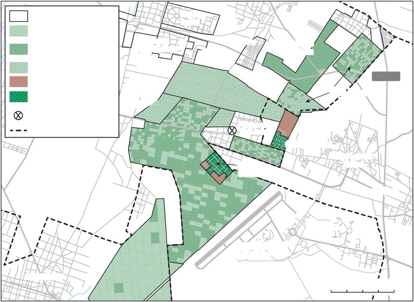
VARLEY AND SALAZAR                                                                                            4

  Area of individual ejido holdings (parcels)              Mexico City Metropolitan Area, growth over time.
  taken into full dominion (%)
                                                                 Central City
      None                                                       1st Ring
      0.01-10%                                                   2nd Ring
      10.01-50%                                                  3rd Ring
      50.01-100%                                                 4th Ring
                                                                 5th Ring
      No remaining ejido property
      No ejido certification
      No individual parcels                       HIDALGO
      Location of areas shown in Figures 2-4
      CDMX boundary
                                                                                            Sou
      Municipality with formal housing                                                          rce:
                                                                                                     Sobri
      development on ejido land                                                                           no 2
                                                                                                                 003

                                                                                                   H
                                                                                                     ID
                                                                                                         AL
                                               San Lucas Xoloc

                                                                                                          G
                                                                                                             O
                               La Piedad

                                                                                               TLAXCALA
              ME

                                                   CDMX
                XIC
                   O

                                                                                San Martin Cuauatlalpan

                                                                                                         PUEBLA
              N

  0           15           30km                      MOREL
                                                             OS

Figure 1 Mexico City Metropolitan Area: conversion of individual ejido holdings
to full private property (sources: authors’ calculations, with data from Padrón e
Historial de Núcleos Agrarios, Registro Agrario Nacional [to end February 2018]; inset:
Sobrino, 2003; map produced by Miles Irving, UCL Geography)

        It is also easy to overemphasize change or continuity. We suggest that most
accounts of the 1992 reforms and the restructuring of housing provision in Mexico are
fixated on change, in their post-hoc assumption that the former enabled the latter. It
reflects the idea that neoliberal urbanism entails a shift from informal to formal. The
association of formalization with neoliberal governance is epitomized by Hernando
THE IMPACT OF MEXICO’S LAND REFORM ON PERIURBAN HOUSING PRODUCTION 5
de Soto’s claim that bringing informal housing into the property market releases ‘dead
capital’ as titles can be used to secure loans (de Soto, 2000). De Soto explicitly presents
formalization as enabling the ‘Third World’ to emulate the capitalist successes of ‘the
West’. Contesting such essentialization, formal and informal can be better understood
as ambiguous, mutually implicated processes, with global relevance (Varley, 2002;
2013; Boudreau and Davis, 2017; Koster and Smart, 2019; Müller, 2019). That said, the
‘significance of informality in cities of the Global South is not under debate’ (Boudreau
and Davis, 2017: 155). We use ‘formal’ and ‘informal’ to refer to landscapes resulting from
processes that can be summarized as ‘obtain planning permission; subdivide land; obtain
building licence; put in services; build dwelling – sell or rent – occupy’ or as ‘occupy first
and all the rest later’, respectively (Connolly, 2020: 125). We make no assumptions about
how far ‘formal’ production complies with planning regulations.
From corporatism to neoliberalism
One potential reason for jumping to conclusions about the impact of
neoliberalism is limited historical understanding. In this section we therefore provide
a brief overview of housing production for lower-income groups in urban Mexico.
—— Changing modes of production and the role of financialization
Perhaps the most remarkable feature of Mexico’s new social housing is simply its
existence, with scale a close second. Government projects never came near to meeting
demand in the twentieth century, leaving renting or self-help construction the only
options for most people. The change is extraordinary. INFONAVIT, the largest lender,
issued well over eight million mortgages from 1995 to 2018, mostly for the purchase of
newly built homes: ‘something which, twenty years ago, was unthinkable’ (Giglia, 2012:
119; translations ours).7 The arrival of the twenty-first century saw the number of new
houses built as complete units with services exceed the number produced incrementally
(Monkkonen, 2011).
Self-help does not mean ‘beyond the state’. Informal housing has made significant
contributions to the economy (reducing labour costs) and political system (Gilbert and
Ward, 1985). The clearest evidence of its political role is the institutionalized nature of
informal settlement on ejido land resulting from Mexico’s corporatist political system
(Azuela, 1989). ‘Peasant’ organizations constituted one of three sectors of the Institutional
Revolutionary Party which ruled Mexico for seven decades until 2000. Ejidatarios have
therefore been able to sell land illegally with impunity, offering purchasers, collectively,
de facto security of tenure. Systematic ‘regularization’ of housing on ejido land became
federal policy in 1973. Titling buttressed Mexico’s authoritarian regime by helping to
counter any political threat from informal settlements by undermining independent
organizations and redirecting demand-making along clientelist channels (Varley, 1985).
Almost 150,000 hectares of ejido land had been expropriated for regularization by the
end of 2018.8
Corporatism also permeated social housing production. INFONAVIT and
agencies for public-sector employees granted mortgages to members of PRI-affiliated
unions for homes built by companies associated with those unions, and loan recovery
was not prioritized (Connolly, 1998). In the early 1990s, however, their activities were
restricted to providing mortgages and facilitating development by private-sector
enterprises. These reforms are often interpreted as a turning-point in housing policy:
neoliberalism unseating corporatism in a ‘commodification of urbanization’ (Pírez, 2014:
481). Mexican technocrats supported the market-led approach, but external pressure
promoting the North American Free Trade Agreement (NAFTA) also contributed
7 Data from Salinas (2016: 223) plus, for 2015 to 2018, BBVA (2020: 44).
8 Figure calculated from a database maintained by Ann Varley.VARLEY AND SALAZAR 6
(Soederberg, 2015). In 2001, one of the World Bank’s largest loans to Mexico was
used to create the Sociedad Hipotecaria Federal [Federal Mortgage Company], tasked
with establishing a secondary mortgage market and stimulating private investment
(Boils, 2004). From 2003, with the SHF providing financial guarantees and absorbing
risk, Mexico became the largest issuer of mortgage-backed securities in Latin America,
attracting equity and pension funds (Soederberg, 2015: 494–6).
The characterization of Mexico’s housing finance system as ‘neoliberal’, however,
requires qualification. INFONAVIT is still the largest lender––the third largest in the
world (Reyes, 2020)––and the rest of the market ‘is either directly or indirectly run
by the government’ (Monkkonen, 2011: 681). NAFTA led to the creation of non-bank
lenders extending credit for construction and securitizing mortgages, but by 2013 they
had collapsed, leaving INFONAVIT the largest issuer of mortgage-backed securities
(Soederberg, 2015; Reyes, 2020). Although the reforms were ‘neoliberal in ideology’,
then, INFONAVIT remains a ‘command and control system’.9 Its dominance has had
negative consequences for Mexico’s new social housing––poor quality, abandonment––as
developer incentives have trumped demand (Monkkonen, 2011; 2019; Reyes, 2020).
—— The land reform: neoliberalism or neocorporatism?
Given the ejido’s status as an emblem of the Mexican Revolution and key to
the rural population’s place in the corporatist system that subsequently emerged, it is
hardly surprising that the Article 27 reforms provoked strong reactions. Assuming that
land would be transferred to private ownership on a massive scale, one commentator
called it ‘the neoliberal destruction of the ejido’ (Calva, 1993: 47). Twenty-five years later,
however, only 19.8% of ejidos had decided in principle to endorse full dominion, and
only 4.3% of their holdings (by area) had been taken into it.10
The reforms were shaped by divisions between campesinistas wanting to liberate
ejidatarios from the worst excesses of state intervention and technocrats hoping to
recapitalize the sector and increase productivity by attracting private investment.
Although the technocrats promoted market-friendly institutions, the result was a
compromise (Cornelius and Myhre, 1998). Reading the reforms from an economistic
perspective overlooks the extent to which, rather than seeking to dispense with the
ejido, they renewed political control in a neocorporatist move (Jones, 1996). Employing
a language of freedom and justice they nonetheless created new government agencies
with new ways of intervening in the ejido, and ‘allow[ed] the State to circumscribe the
autonomy of the ejido by a host of rules and regulations which permit intervention’
(ibid.: 194).
The most salient of those regulations concern privatization via adoption of
dominio pleno. Only individual parcels––approximately one-third of ejido holdings––are
eligible. To endorse full dominion requires a special ejido meeting, with stringent
quorum and voting requirements. Individual ejidatarios may then request full dominion
over their parcels. If they wish to sell, however, relatives, those who have worked the
land, other community members, and the community itself have the right of first refusal,
with a formal valuation required. Another meeting approves individual changes of
ownership. By late 2017, only 11.6% of the area held as individual parcels had been taken
into full dominion.11
Dependent on community approval and subject to first-refusal requirements,
ejidatarios do not enjoy the same rights as other property owners. Their individual
entitlements are still effectively limited to usufruct (Méndez, 2016: 196).
9 We cite directly one reviewer’s insightful observations.
10 Authors’ calculations from official data (RAN, 2017). Information to 2 August 2017 (most recent data available).
11 Source: see note 10.THE IMPACT OF MEXICO’S LAND REFORM ON PERIURBAN HOUSING PRODUCTION 7
The Article 27 reforms did not produce massive privatization or recapitalization
of the countryside; nor did they counter rural poverty (ibid.). Enabling ejidatarios
to dispose of their property legally ‘essentially ratified a long-standing status quo’
(Cornelius and Myhre, 1998: 1). The land reform was neither as neoliberal nor as
radical as had been assumed (Jones, 1996). It was certainly not a housing policy: the
urban implications were only considered later (Jones and Ward, 1998; Cruz, 2001;
Hernández, 2010; cf. Boudreau et al., 2016; Salinas, 2016). If there is a link between land
privatization and the new housing model, it is not one that was heralded––as it easily
could have been––by its advocates.
The impact of the 1992 reforms on the Mexico City Metropolitan Area
To understand how the 1992 reforms could have made ejido land available for
social housing developments, we examine the response to opportunities presented
by the new legislation. Although ejidatarios can now alienate their land, further
informal development is still a possibility if planning regulations are not observed. In
the past, the government has often used expropriation to provide title for residents
who purchased land illegally from the ejido and, until the mid-1980s, expropriation
was also used for urban projects including university campuses, industrial zones and
housing (Varley, 1985). Since then, it has been used far less, partly because of ejidatario
opposition, and has not been used for new housing in the Mexico City Metropolitan
Area (Azuela and Saavedra, 2017). It is not therefore considered here.
Before any of the new options can be pursued, the community must agree the
area, boundaries and categories––individual parcels, common-use land or human
settlements–– of the land it owns, enabling certificates (only, at this stage) to be issued
to rights-holders. As of early 2018, 87% of 377 surviving ejidos in the Mexico City
Metropolitan Area had taken up certification (or, excluding CDMX, 92% of 337 surviving
ejidos).12
—— Joint-venture development companies
If any of the new legal procedures had been intended to promote housing
development, it would have been the formation of joint ventures between ejidos
(providing land) and developers (providing capital) in a sociedad mercantil inmobiliaria
[property development company]. When the urban implications of reform were
eventually considered, this was the favoured option of both agrarian and urban
ministries (Jones and Ward, 1998; Procuraduría Agraria, 1999).
If it worked, this could be an instance of external investment making the
periurban ejido profitable, since ejidatarios are unlikely to have the resources needed
to develop their land. By and large, it has not worked, at least not to ejidatarios’ benefit.13
In the Metropolitan Area, only a few ejidos have contributed common-use land, totalling
under 750 hectares, to joint ventures. Between 1994 and 1999, the ejido of San Mateo
Tlaltenango created four companies, with different investors, to develop upmarket
housing and a golf club in Cuajimalpa (CDMX). In 1997, joint ventures in adjacent
ejidos in Cuautitlán Izcalli catered for the other end of the market: Tepojaco and La
Piedad worked with the same investor to provide land for 11,301 houses in Lomas
de San Francisco (1999) and 2,849 in La Piedad (2001). An unusual feature of the La
Piedad conjunto is that it occupies the periphery of the ejido, around a hub of informal
settlement––now regularized––with formal and informal housing interspersed in places
(see Figure 2).
12 Authors’ calculations, data from PHINA. Most ejidos that did not pursue certification had already lost/sold most of
their land; some are in the mountains. Fifty-three ejidos, mostly in CDMX, no longer had any land to certify.
13 A predecessor of joint ventures, entailing land swaps with developers, was deemed contrary to ejido interests and
abandoned in 1971 (Varley, 1985).VARLEY AND SALAZAR 8
Ejido of INFONAVIT
Norte
Santa María Tianguistengo
Old quarries with
go
Fraccioamiento
some informal housing ilan San Antonio
Hu housing development
sé Ejido of
n Jo
Sa La Piedad
of
do Rinconada
Eji San Miguel
housing
development
Conjunto La Piedad La Piedad
Ejido of
Ejido of Lagoon
iver
housing development
San José
San Francisco
n.R
Huilango
Tepojaco
titlá
Lomas de Ejido of
Quarries
u
San Mateo
Cua
San Francisco
housing development Xoloc
Map data © OpenStreetMap contributors, CC-BY-SA, opendatacommons.org
Ejido boundaries Informal housing
Regularized informal housing:
Government housing development colonia La Piedad 0 500m
Figure 2 Formal and informal housing developments, Cuautitlán Izcalli, Mexico
City Metropolitan Area (source: authors’ analysis of maps from Sistema de Información
Geoespacial, Registro Agrario Nacional [RAN-SIG: see text]; map produced by Miles
Irving, UCL Geography)
Another 1997 joint venture was to provide industrial land in Texcoco, but the
partners argued about the price and eventually a legal case was brought because the
investor had refused to pay up (Maya, 2004). This is not the only example of legal
conflict or of ejidatarios losing their land. As the land is valued at agricultural rates, the
ejidatarios become minority shareholders (Jones and Pisa, 2000)––in the cases cited,
with 10 to 48% of the shares (Aguado and Hernández, 1997; Maya, 2004; Salazar, 2014).
These low valuations (the cost of which may itself be prohibitive), the unfair distribution
of risk and long lead times have sometimes led ejidatarios––including those from
Cuajimalpa––to sell their shares to the developer (Jones and Pisa, 2000; Patiño, 2009).
Traditional suspicion of dealing with outsiders would be amply confirmed by such
experiences, and fewer joint ventures have been created since the 1990s (Méndez, 2016:
85). Only one development company has been recorded more recently. In 2008, La
Magdalena Chichicaspa, in the hills west of the city, set up a company to develop 300
hectares occupied in part by sand and gravel quarries. Eight years later, the land was
advertised for residential development at US $13.2 million––as it is close to Bosque Real,
the most ambitious development in Mexico (see below) ––but legal infighting between
different groups of ejidatarios continues to block development.14
14 Propiedades.com (2016) Terreno habitacional en venta: Magdalena Chichicaspa [WWW document]. URL: https://
propiedades.com/inmuebles/terreno-habitacional-en-venta-magdalena-chichicaspa-la-magdalena-chichicaspa-
mexico-3354770 (accessed 18 September 2020: the page now carries a banner declaring that the land is not on
the market).THE IMPACT OF MEXICO’S LAND REFORM ON PERIURBAN HOUSING PRODUCTION 9
—— Urban zones
The 1993 Agrarian Law provided for housing development for ejido communities.
Creating a new urban zone involves subdividing land and allocating plots to ejidatarios
or people who have lived in the ejido for over a year. These plots can then become private
property. Land can be set aside for future growth [reserva de crecimiento]. However, the
law explicitly acknowledges that the urban zone might already be occupied and defines
an ejido’s ‘human settlements’ as the urban zone and fundo legal [original village].
‘Village’/township expansion is likely to have absorbed ejido land, reinforcing the idea
of urban zones as already settled.
Almost half of the Metropolitan Area ejidos (179) have a certified urban zone,
with 6,500 hectares subdivided internally, 2,120 hectares awaiting subdivision and 642
hectares reserved for future growth at the time of certification.15 These distinctions do
not appear meaningful on the ground. Some ‘reserves’ were already occupied (in La
Piedad, the ‘reserve’ is the informal settlement: see Figure 2)––sometimes as densely as
adjacent ‘village’ areas (as in Tlapala, Chalco: see Figure 3).16 In San Martín Cuautlalpan
(Chalco), 193 hectares of informal settlement designated as an internally subdivided
urban zone were subsequently ‘reserved for future growth’ (see Figure 3). By contrast,
one ‘subdivided settlement’ is an uninhabited area in the forested mountains of Santa
María Mazatla (Jiltozingo), west of the city. Seemingly fictitious urban zones may
anticipate real estate profits: for instance, reserves near expensive ‘ranches’ or country
clubs (Concepción Jolalpan, Tepetlaoxtoc, and San Pablo Tecalco, Tecámac).
Most urban zone certifications have simply acknowledged existing settlements.
These include colonial villages where (unusually) the ejido incorporated the fundo
legal, as in Huexoculco (Chalco; see Figure 3) and cases where the settlement originally
accommodated hacienda workers, as in Xala and Tetepantla in the north-eastern
municipality of Axapusco. Most are extensions of an old village/township.
Not surprisingly, then, urban zones are often associated with further
informal settlement. Self-built housing often spreads out from village-extension urban
zones––around Zitlaltepec (Zumpango), San Martín de las Pirámides, or San Bernardino
(Texcoco)––or from a separate informal settlement now designated an urban zone (e.g.
Nueva Santa Rosa, from where housing has spread westwards within the same ejido,
Santa Isabel Ixtapan, Atenco and northwards into Tequisitlán, Tezoyuca). In some
cases, fragmented urban zones and other fragments of ejido land form a patchwork,
all occupied by informal settlement of varying density, as in La Magdalena Panoaya
(Texcoco), for instance.
In theory, plots in any subdivided zone can receive titles. Very few have received
them. Those that have include the mysterious ‘settlement’ in the mountains of Santa
María Mazatla and a few others in areas with tourist activity. Overall, the State of
Mexico has seen a particularly low number of urban zone titles issued (Méndez, 2016).
The urban zone provisions have both legitimated and perpetuated informality.
They follow a pattern set by similar provisions in earlier legislation, which played a key
role in twentieth-century urbanization (Varley, 1985).
—— Full dominion
Adoption of full dominion is the most innovative procedure. Take-up has been
limited, but where demand for development land is higher, in periurban areas, it should
be higher too (Salazar, 2009).
Table 1 analyses adoption of full dominion in the Mexico City Metropolitan Area,
where 22,247 hectares had been privatized by early 2018. Only ejidos with individual
15 Source: see note 12.
16 Where two names are given––e.g. Tlapala, Chalco––the first is the ejido, the second, the municipality in which the
‘village’ is located. Where only one is given––e.g. San Martín de las Pirámides––it refers to both the ejido and the
municipality.VARLEY AND SALAZAR 10
Pueblo San Martín
Nuevo Cuautlalpan
San Lucas
Amalinalco Hacienda Villas de Hacienda de los González
San Juan San Martín
Hacienda
de la Compañía
San Gregorio
Cuautzingo Los Héroes
Chalco
Santa María
Huexoculco
Hacienda de
Guadalupe Hacienda
Los Alamos Guadalupe
Rancho Santa Chalco
Built-up area
María Atoyac
Housing developments
Ejido
Colonia Hacienda
Ejido urban zone
del Moral del Moral
Former hacienda
La Candelaria MEX 115
Tlapala 0 1km
Map data © OpenStreetMap contributors, CC-BY-SA, opendatacommons.org
Figure 3 Formal housing developments, ejidos and former haciendas around San
Martín Cuautlalpan, Chalco, Mexico City Metropolitan Area (source: authors’ analysis of
maps from Sistema de Información Geoespacial Registro Agrario Nacional [RAN-SIG:
see text]; map produced by Miles Irving, UCL Geography)
holdings [parcelas] can transfer these parcels to private ownership, and not all ejidos
have registered individual parcels on certification. However, they can also transfer
common-use land to parcels later, and twenty have done so, adding to the area that
can be privatized. The results shown in Table 1 and Figure 1 indicate a significant
relationship between centrality and full dominion, suggesting that urban demand is
indeed crucial.
There is a link, moreover, to urban zones. Of the 314 certified ejidos with
individual parcels, 45% of those with an urban zone had adopted full dominion, but
only 33% of those without one, and 15,240 hectares had been privatized in the former
compared with only 7,007 hectares in the latter.17
Many privatized parcels––particularly but not exclusively near an urban zone––are
being developed for low-income housing, in a continuation of the familiar process whereby
ejidatarios sell their parcels piecemeal without following planning regulations. This can
produce a distinctive topography, where individual parcels gradually become city blocks.18
Further out, parcels are more likely to be occupied by a single house, perhaps belonging to
the owner or a relative, before more plots are sold over time.
Tlapala provides a typical example (see Figure 3). Informal settlement spreads
out from the village, especially beyond the urban zones (predating certification in 1995)
17 The number of ejidos with or without an urban zone adopting full dominion is significant (chi-square 5.05, p=0.025).
One hundred and seventy-three ejidos with parcels had an urban zone, as did six without parcels.
18 Thousands of extremely long and narrow parcels on the former Texcoco lakebed, the result of ploughing with ox
teams, are set to become city blocks (Hernández, 2010).TABLE 1 Ejido land taken into full dominion, Mexico City Metropolitan Area
Ejidos with individual For all ejidos with individual parcels (N = 314*) For ejidos that have endorsed full dominion (N = 124*)
parcels as % of all % endorsing full Area taken into full dominion % of area in parcels taken % of area in parcels taken Median % of area in parcels
Centrality certified ejidos (N = 329) dominion (nearest hectare) into full dominion into full dominion taken into full dominion
City centre & 1st ring (15) 55 55 1,282 47 59 63
2nd ring (14) 87 67 7,511 45 53 61
3rd ring (20) 100 47 7,971 17 35 49
4th ring (9) 100 35 4,226 21 46 27
5th ring (18) 99 18 1,258 2 7 9
ALL (76) 95 40 22,247 14 33 46
notes: Data only for ejidos taking up certification (329 of 377; see note 12).
* Includes Coacalco and San Cristóbal Ecatepec, which had no parcels on certification but subsequently converted common-use land to parcels.
Areas incorporate conversions from common use to parcels in these and eighteen other ejidos.
Centrality definitions from Sobrino (2003), on basis of municipal population size and growth, economic activities, location and functional integration (journey to work).
Number of municipalities in parenthesis. Ejido property may cross municipal boundaries but for this analysis is assigned to the municipality where the fundo legal (see text) is officially located.
Centrality and (a) number of ejidos adopting full dominion (b) percentage of parcelled land taken into full dominion in ejidos endorsing full dominion statistically significant (chi-square 38.5 and Kruskal-Wallis
H 23.83; p = 0.0 in both cases).
sources: Authors’ calculations, data from PHINA to end of February 2018 (see text)
THE IMPACT OF MEXICO’S LAND REFORM ON PERIURBAN HOUSING PRODUCTION
11VARLEY AND SALAZAR 12
to the south and east. Housing is now strewn over most of the ejido, alongside cultivated
parcels. Six per cent of the area in parcels has been privatized, and most is already at
least partly occupied, suggesting that the intention was to sell, but both privatized and
non-privatized parcels are being developed.
It is not, then, only privatized parcels that are being sold, nor only those near
an urban zone. Housing is scattered across parcels in San Martín de las Pirámides
and Zitlaltepec, both of which have an urban zone but no privatized parcels. Zapotlán
(Atenco) has no urban zone, but three-fifths of the area in parcels has been privatized, and
informal settlement occupies both privatized and other parcels. Nearby La Resurrección
has neither urban zone nor privatized parcels, but housing is nonetheless appearing on
the parcels. Overall, however, the combination of an urban zone, individual parcels and
full dominion seems to typify ejidos currently undergoing informal development.
Mapping ejido contributions to urban enumeration districts in the Metropolitan
Area outside CDMX shows that 58% of former agrarian property now incorporated
into the built-up area in this periurban fringe was once parcels, but only 26% was
certified urban zones.19 If, for argument’s sake, the urban zones are regarded as predating
certification, and parcel development as post-certification, the area of informal settlement
would have more than doubled since certification (from less than 7,200 to almost 15,800
hectares). However, that suggestion overlooks not only the possibility that not all pre-
certification informal settlement was classified as urban zones, but also the extent to
which privatization has supported formal development, the topic to which we now turn.20
Ejido contributions to formal housing development
In this section we examine the location of the new housing developments in
Mexico City’s periurban fringe and seek to explain our finding that they are more likely
to be found on private than on ejido land.
—— Occupation of ejido land
Social housing has indeed been developed on ejido land in the Metropolitan
Area since 1992, as have middle-class and even luxury developments. Authorizations
have been issued for 3,425 hectares of ejido land and over 233,000 houses (see Table 2);
83% of the houses, occupying 73% of the land, are in the ‘social’ category, with higher
densities than more upmarket developments.
In the late 1990s, authorizations started to appear for what has become 1,600
hectares of social housing projects in five ejidos in the north-east (Tecámac and
Ecatepec municipalities). Construction of almost 130,000 units by some of Mexico’s
largest developers (SADASI, Urbi, ARA and GEO) has been authorized and development
is still ongoing. Another 588 hectares of housing on ejido land has been authorized
elsewhere in this sector (see ‘starred’ municipalities, Figure 1).
A smaller group of social housing projects can be found in five ejidos in
Chalco: almost 15,000 houses on 222 hectares. Each ejido houses a single development
(sometimes built in stages––for example, the three sections of Pueblo Nuevo developed
by GEO on San Martín Cuautlalpan land; see Figure 3).
The north-west provides further examples, including two contrasting pairs of
adjacent ejidos: the already decaying social housing developed as joint ventures on
Tepojaco and La Piedad land (see above) and, further south, upmarket housing in San
Bartolomé Coatepec and San Cristóbal Texcalucan (Huixquilucan), where the Bosque
Real development offers its residents a welcome ‘to the First World’ (Müller and
Segura, 2017: 158). Now occupying over 690 hectares of land from the two ejidos, Bosque
19 The rest is in common use (7%) or not identified (10%). See note 6.
20 Some land in the north-west has been developed as warehouse/distribution centres in industrial parks, e.g., in San
Martín Obispo (Maya, 2004; David, 2012).TABLE 2 Contribution of ejido and private land to housing developments in State of Mexico municipalities, Mexico City Metropolitan Area
Housing developments on ejido land Housing developments on private land All housing developments
Social Other Total Social Other Total Social Other Total
Authorizations (N) 65 18 83 269 47 316 334 65 399
Houses 193,976 39,264 233,240 594,122 54,602 648,724 788,098 93,866 881,964
Area (hectares) 2,503 923 3,425 8,195 1,240 9,435 10,698 2,163 12,860
Authorizations (%) 16 5 21 67 12 79 84 16 100
Houses 22 5 26 67 6 74 89 11 100
Area 20 7 27 64 10 73 83 17 100
For AREA only:
(a) Centrality
1st ring % (1,077 ha) 0 66 66 5 30 35 5 95 100
2nd ring % (3,249 ha) 18 1 18 55 27 82 73 27 100
3rd ring % (5,767 ha) 34 3 37 62 1 63 96 4 100
4th ring % (2,640 ha) 0 0 0 100 0 100 100 0 100
5th ring % (127 ha) 0 0 0 100 0 100 100 0 100
(b) % of each housing 23 42 77 57 100 100
type on ejido/private land
notes: Housing type: ‘social’ includes ‘social interest’, ‘progressive’ and ‘popular’; ‘other’ includes ‘medium’ and ‘residential’. Additional uses (e.g. commercial) ignored. One or two developments with ‘social’
and ‘other’ housing are allocated to whichever category includes most houses. Percentages to nearest integer.
Centrality: see Table 1. Some conjuntos are developed in stages. Where additional houses are subsequently authorized in an area covered (in outline) in an earlier authorization, only that first authorization is
counted. Authorizations are only counted separately if they relate to a different, albeit adjacent, area of land.
sources: Gaceta del Gobierno del Estado de México––conjunto urbano authorizations, cross-checked with other sources, and RAN-SIG, 1993 to end of February 2018 (see text).
THE IMPACT OF MEXICO’S LAND REFORM ON PERIURBAN HOUSING PRODUCTION
13VARLEY AND SALAZAR 14
Real brought together 50 developers to build detached houses and tower blocks around
a dozen kilometres of internal roads, two golf courses, a club house, lakes and fountains.
In the 1990s, investors reportedly paid ejidatarios over a million [old] pesos each for
privatized parcels, before selling to developers for over five times as much (Aguilar, 2010).
When they ran out of money, Mexico’s richest man, Carlos Slim, rescued the project, and
new sections have since been authorized. Other developments, such as middle-class high-
rises in Paseos del Bosque (‘with golf course views’), also occupy Coatepec land, squeezed
in at the other end of an informal settlement resulting from earlier sales by ejidatarios.
Land has mostly been acquired by purchasing privatized parcels. When ARA
developed 60 hectares from two neighbouring ejidos inside a volcanic crater, the land for
the ex-Hacienda de Xico conjunto came from seven parcels of Villa de Chalco ejido, as
recorded in the authorization. Similarly, the authorization for 95 hectares of Bosque Real
refers to purchase of over one hundred parcels. Most parcels in areas developed for housing
have been privatized, suggesting that the community (or at least those holding parcels
in that area) reached a collective deal with the developers. Such a process presumably
accounts for the large contiguous areas of land developed in neighbouring ejidos in Tecámac.
That purchase of privatized parcels is preferred to joint ventures is demonstrated
by its scale and timing: the joint ventures were earlier experiments (Aguado and
Hernández, 1997). In La Piedad another project, Rinconada San Miguel, was authorized
in 2005, with better quality social housing, built entirely on privatized parcels (see
Figure 2). Where there were no parcels at certification, common-use land could be
converted later. To the north of the Metropolitan Area, Coacalco converted 212 hectares
to parcels in 1998; two years later, SADASI obtained authorization to build social
housing on this land. Only one of 20 Metropolitan Area ejidos that have contributed land
to conjuntos––Tepojaco––has not endorsed full dominion.
Not all parcels in the housing developments have, however, been privatized.
Vacant blocks can be found, in a seemingly random pattern: for example, in the Tecámac
developments. Some could be reserved for amenities, but others––for example, adjacent
to peripheral highways––may have been retained by owners looking for higher returns
from a supermarket chain or other corporate interest. Some ejidatarios may simply
refuse to sell. Satellite imagery shows a few parcels in cultivation in the middle of
building operations, or even the odd building that still exists, in Pueblo Nuevo for
instance (see Figure 3).
These observations challenge claims about ‘dispossession’. Community protest
has occasionally been recorded: in San Gregorio Cuautzingo, ‘there are people who love
their land … one señor … threw himself down … they’d have to kill him if they wanted
his land’ (Salinas, 2009: 31; and see Figure 3). Ejidatarios complained that ‘there are
people who don’t want to sell, but [ejido authorities] have put pressure on them’ (ibid.).
Whether out of love for the land or in anticipation of a better deal, some ejidatarios
do, apparently, resist. If all were merely victims, it would be difficult to account for the
micro-geographies of Mexico’s new periurban landscapes.
—— Heirs of the hacienda?
With thousands of hectares of social housing and the most ambitious luxury
development in Mexico occupying former ejido property, the evidence for Article 27
reforms having a dramatic impact on the Mexico City Metropolitan Area looks strong
at first sight. Our data show, however, that developers build on existing private property
rather than privatized ejido land. Ejidos account for only 27% of the 12,860 hectares
of housing developments authorized by State of Mexico authorities (see Table 2). 21
21 Availability could explain contribution to housing development. A correlation exercise for the 59 State of Mexico
municipalities in the Metropolitan Area of Mexico City showed that municipal size is related to the area developed
(Pearson 0.249; p = 0.06), but there are weak and insignificant relationships between the area in ejidos and ejido-
based housing development, in both absolute and relative terms.THE IMPACT OF MEXICO’S LAND REFORM ON PERIURBAN HOUSING PRODUCTION 15
Only eight out of 59 State of Mexico municipalities in the Metropolitan Area have any
conjuntos on former ejido land: Acolman, Coacalco, Chalco, Cuautitlán Izcalli, Ecatepec,
Huixquilucan, Tecámac and Valle de Chalco Solidaridad (see Figure 1).22
Social housing is even less likely than middle/higher-income developments
to occupy ejido land: 23% and 43%, respectively (see Table 2). Developers have been
roundly criticized for their readiness to relegate lower-income groups to the middle
of nowhere, and developments on private land can be found in all of the ‘rings’ of
metropolitan expansion, but there are no higher-income conjuntos and no developments
on ejido land in the two outermost rings (see Table 2). If higher-income groups constitute
a more attractive market, but one that is averse to remote locations, developers may find
it worthwhile buying ejido property only in better-located areas, and only/primarily
for middle-class developments. In the first ring there are no lower-income conjuntos
on ejido land, and only here does the area of middle/upper-income developments far
outstrip that occupied by social housing.
Geography provides another pointer to developer preference for private land:
housing developments often occupy private property immediately adjacent to vacant
ejido land. In the east of Chicoloapan municipality, for example, five projects by some
of the biggest developers, including ARA, GEO and Casa Beta, are almost surrounded by
land from two ejidos, much of it still cultivated. Further south, Ciudad Cuatro Vientos
is entirely surrounded by ejido land that was still in cultivation when development was
approved. A little further south again, several developments appear to be squashed in
between ejidos in Chalco (see Figure 3, especially Los Álamos and Hacienda Guadalupe
Chalco). In Tecámac, Rancho la Capilla sits between four ejidos, in the middle of large
areas in cultivation. Not far to the west, GEO’s Paseos de San Juan is almost isolated in
a hook-shaped ‘promontory’ of private land between ejidos (see Figure 4).
The land on which these ‘island’ developments are built often has a particular
history, suggested by their names. Developers prefer names evoking a desirable
environment––bosques [woods], lomas [hills] or jardines [gardens]––or social status:
villas, hacienda or, on a more ‘homely’, scale, rancho. Invocations of pre-Revolutionary
landed estates can be found everywhere. Most refer to specific haciendas, sometimes
underlining the point by adding ‘Ex’: e.g. Ex-Hacienda de Xico (once owned by Hernán
Cortés). In some cases, such as Xico, the hacienda buildings [casco] or their ruins are still
standing. The Chalco region had a particularly dense concentration of haciendas, and
some hacienda buildings can still be found surrounded by social housing (see Figure 3).
In Zumpango, a small chapel from the hacienda of San Juan de la Labor is now part of
the Paseos de San Juan neighbourhood centre (see Figure 4).
The land on which many developments were built, then, is former hacienda land
that has never been part of an ejido. This is true of the earliest conjuntos, in Ixtapaluca,
including Cuatro Vientos. A little further north, the Chicoloapan developments occupy
part of the Tlalmimilolpan hacienda. Landowners whose property was taken in the
agrarian reform could keep up to 50 hectares; most kept land around the casco, which
remained in or out of cultivation until housing development presented new economic
opportunities. In Chalco, Villas de San Martín occupies the 47.5 hectares of Hacienda de
los González left after 4,748 hectares were restored to San Martín Cuautlalpan in 1930;
the casco ruins were demolished during development (Pérez, 2010; see Figure 3). Other
landowners evaded reform by selling off ‘fractions’ of their property, some of which are
now being developed. In the north-east, Paseos de Tecámac and Hacienda del Bosque
occupy fractions of San Nicolás la Redonda, which contributed land to neighbouring,
still cultivated, ejidos; the nearby casco is now (like others) a wedding venue. Paseos
de San Juan was created from three ‘fractions’ of San Juan de la Labor (see Figure 4).
22 Tizayuca has conjuntos on ejido land, but as authorizations are not published in the state gazette, they are excluded
from our analysis.VARLEY AND SALAZAR 16
San Juan
Housing developments Santa de Guadalupe TIZAYUCA
Isabel
Individual ejido parcels
Hacienda Santa Fe San Bartolo
Individual parcels taken de los Encinos
into full dominion Jardines Naucalpan
Magnolias
Ejido - other
MEX 85
Urban growth reserves San Bartolo
San Cuautlalpan San Lucas
Regularized informal housing
Sebastian Xoloc
Former hacienda of
San Juan de la Labor
Paseos de
Municipal boundary
San Juan
San Lucas
Colonia Ejidal
Xoloc
San Lucas
Colonia Xoloc
Santa Lucia
ZUMPANGO
TECÁMAC
Santa Lucia
Air Base
Santa Ana
NextlaIpan
NEXTLALPAN
0 2km
Map data © OpenStreetMap contributors, CC-BY-SA, opendatacommons.org
Figure 4 A preference for private land? New housing developments, Zumpango
and Tecámac, Mexico City Metropolitan Area (source: authors’ analysis of maps from
Sistema de Información Geoespacial, Registro Agrario Nacional [RAN-SIG: see text];
map produced by Miles Irving, UCL Geography)
Another strategy to escape reform after the Revolution involved the creation of
urban subdivisions: south of the city centre, the Portales and Nativitas neighbourhoods
were developed to frustrate attempts to claim the land as ejidos (Varley, 1989). Similarly,
many of today’s housing developments mark the imprint of the landed estate on the
contemporary city.
—— ‘A property which is and which is not’: developers and the ejido
Asked his opinion of Mexico’s social housing, architect Carlos García Vélez,
former GEO vice-president, responded, somewhat cryptically, that the ‘limiting factor’
was the way the ejido–– ‘a property which is and which is not and which takes different
forms’––shapes private land. When a developer buys a property, ‘the form of the
ejido sets the pattern for growth and everything has to be planned around that’. The
‘labyrinth’ of different types of property frustrates efforts to interconnect different
housing developments (quoted in Sánchez, 2012: 302).
These comments from one of those most closely identified with Mexico’s new
housing model reflect both private sector mistrust of the ejido and the spatial logic
driving its land acquisition strategies.
Business interests have long been wary of the ejido because of its reputation for
internal and external conflict. Fractionalization and the frequent election of new ejido
authorities hinder consistent decision-making (Aguado and Hernández, 1997; Jones
and Ward, 1998; David, 2012; Herbert et al., 2012). Ejidatarios are notoriously litigious,
using opportunities afforded by corporatism to bring actions (e.g. against expropriation:THE IMPACT OF MEXICO’S LAND REFORM ON PERIURBAN HOUSING PRODUCTION 17
Varley, 1985; see also cases quoted above). Until 2013 there was no time limit on their
ability to contest the price paid for newly privatized land (Méndez, 2016: 5, 88). Even the
executive has been reluctant to confront them. A federal programme creating urban land
reserves on ejido property in the 1980s was so plagued by opposition that the president
refused to pursue expropriations that had not first been negotiated with the ejidatarios
(for additional compensation); his successor simply cancelled the programme (Azuela
and Saavedra, 2017).
The ability to acquire land cheaply––given ejidatarios’ lack of business
acumen (Salazar, 2014)––is one reason why critics regard conjunto development as
‘dispossession’ (Salinas, 2009). Low costs are essential, but interviews with social
housing developers indicate that they are offset by higher infrastructure costs in
remote locations: ‘economies of scale and weak regulations’ are therefore crucial
(Libertun, 2018: 418). This is particularly true of the larger, highly capitalized developers
dominating production in peripheral locations, with industrialized building techniques
and prefabricated components that require expensive equipment and better-qualified
workers but significantly reduce labour costs. Large expanses of land accommodate
equipment and onsite production of materials, reducing production costs as well as
the impact of fixed costs such as legal or administrative fees. As remote locations
are unattractive to higher-income households, who demand better amenities, there
are fewer competitors in the market, placing developers in a strong position when
negotiating authorizations with local authorities; speedier turn-around again reduces
costs (ibid.; Castro et al., 2006: 454–5).
In this context, the ejido is less attractive than private land because of the
number of potential vendors, with different views on whether, when and how to sell.
Ejido holdings are fragmented: since agrarian reform was intended to ensure political
stability, the largest possible number of beneficiaries were included. No parcel can
occupy more than 5% of the total area (Méndez, 2016: 74). Consequently, developers
may have to deal with hundreds of individual holdings in a chequerboard pattern of
privatized and non-privatized parcels (see San Lucas Xoloc, Tecámac, Figure 4). The
individual nature of ejido privatization is ‘dysfunctional’ from an urban perspective
(Hernández, 2010: 620). Small wonder, then, that, apart from developers who manage
to sign up an entire community, the private sector shuns the ejido.23
Interconnected processes
Recent theorizations view formal/informal ‘as a duality of modes of interaction …
each is entangled with, and inseparable from, the other and invariably invokes the other’
(Koster and Smart, 2016: 21). Informal development still takes place under the ‘banner’
of legal procedures such as urban zone creation or adoption of full dominion. Ejidatarios’
wariness of both commercial interests and internal authorities means they often prefer
individual sale, following a ‘bird in the hand’ logic. Not understanding the law leads
many to believe they can freely sell privatized land, ignoring planning requirements
(Cruz, 2001). Full dominion promises higher prices (Maya, 2004); but the appearance
of informal housing on adjacent privatized and non-privatized parcels in many ejidos
suggests there may be little difference overall.
The intertwining of formal and informal goes beyond use of the law to provide
a veneer of legitimacy. An expansion of informal settlement in ejidos has been observed
in areas with large amounts of new social housing (Connolly, 2020: 134). Our evidence
suggests that conjuntos on ejido land, in particular, may also promote informal
development. In the Metropolitan Area, a similar proportion of parcelled land has been
23 Specialist developers focusing on land acquisition and planning approval reduce risk in relation to ejido land
developed for commercial uses (David, 2012). Whether the same applies to residential development is not yet
known.You can also read