Farmington City Planning Commission

         February 17, 2022
←
→
Page content transcription
If your browser does not render page correctly, please read the page content below
Farmington City Planning Commission
February 17, 2022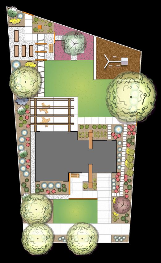
Thursday February 17, 2022
                                               Public Meeting - Farmington City Hall
                                               160 S. Main Street, Farmington, Utah.
                                                      Study Session: 6:30 p.m.
                                                    Regular Session: 7:00 p.m.

Farmington City Planning Commission meetings, including this meeting, are open to the public. If you wish to view the regular
session online, the link to the live hearings and to comment electronically can be found on the Farmington City website at
www.farmington.utah.gov. If you wish to email a comment for any of the listed public hearings, you may do so at
crowe@farmington.utah.gov by 5 p.m. on the day listed above.

7:00    1.   Approval of 02.03.2022 Minutes
        2.   City Council Report

SUBDIVISION APPLICATIONS
      3. Phil Holland (Public Hearing) – Applicant is requesting a recommendation for schematic subdivision approval for the
         proposed Juniper Estates subdivision, a 6-lot subdivision located at approximately 400 S 650 W on 3.15 acres, is in the
         AE (Agriculture Estates) zone. (S-1-22)

        4.   Daniel Barton – Applicant is requesting a final subdivision approval for the proposed Kirkham Orchard subdivision, a 5-
             lot subdivision, located at approximately 1000 North Compton Road. The property is in the LR-F (Large Residential –
             Foothill) zone. (S-20-21)

ZONE TEXT AMENDMENT APPLICATIONS
      5. Farmington City (Public Hearing) – Applicant is requesting a recommendation of approval for a zone text change to
         consider amendments and additional text to the Zoning Ordinance enacting Water Efficient Landscape requirements.
         (ZT-17-21)

        6.   Farmington City (Public Hearing) – Applicant is requesting a recommendation of approval for a zone text change to
             consider amendments and additional text addressing electronic meeting participation and other minor changes regarding
             the Organization and Procedures of the Planning Commission. (ZT-1-22)

OTHER BUSINESS
     7. Miscellaneous, correspondence, etc.
           a. Rules of Order
           b. Policies and Procedures
           c. Other

Please Note: Planning Commission applications may be tabled by the Commission if: 1. Additional information is needed in order to
take action on the item; OR 2. If the Planning Commission feels, there are unresolved issues that may need additional attention before
the Commission is ready to make a motion. No agenda item will begin after 10:00 p.m. without a unanimous vote of the
Commissioners. The Commission may carry over Agenda items, scheduled late in the evening and not heard to the next regularly
scheduled meeting.

Posted February 11, 2022                                                                          Carly Rowe, Planning Secretary
FARMINGTON CITY
                                                       PLANNING COMMISSION
                                                          February 03, 2022

REGULAR SESSION

Present: Chair Rulon Homer; Vice Chair Erin Christensen; Commissioners Larry Steinhorst, John David Mortensen, Mike Plaizier and
Samuel Barlow. Staff: Community Development Director David Petersen, Assistant Community Development Director Lyle Gibson,
City Planner/GIS Specialist Shannon Hansell, and Planning Secretary Carly Rowe.

Rulon Homer opened the meeting at 7:07 PM.

Item #1 Approval of Minutes

Mike Plaizier made a motion to approve the minutes from January 20, 2022, with one correction on page 7, changing the name of
one issue to Mortensen instead of Steinhorst. Samuel Barlow seconded the motion, which was unanimously approved.

Item #2 City Council Report

Community Development Director Dave Petersen reported on the February 1, 2022, City Council meeting. He mentioned the GSBS
presentation of the draft master plan for a mixed-use area for the area north of Park Lane to Shepard Lane, between the Union
Pacific tracks and the Denver and Rio Grande Western Rail Trail (D&RGW Rail Trail). The Commission will see it again as early as
March 3, likely as a public hearing. Canopy Square was supposed to be on the agenda, but they took themselves off because of the
STACK discussion item of the pedestrian greenway. The Wasatch developers want to be consistent with those goals and plans. In
summary action, the Council approved the subdivision re-establishing the Station Parkway dedicated Right of Way (ROW) by
Nordstrom Rack and Chick-fil-A.

SUBDIVISION, SPECIAL EXCEPTION AND ZONE CHANGE APPLICATION

Item #3 Joey Green (Public Hearing) – Applicant is requesting recommendation of Schematic Subdivision approval for the
proposed Monterra Subdivision, a four-lot subdivision at approximately 1875 N 1075 W, on 1.04 acres – a recommendation of
approval for a rezone from the current zoning of Agricultural (A) to Large Residential (LR) and approval for a special exception for
access to one building lot across another. (S-21-21, Z-5-21, M-11-21)

City Planner/GIS Specialist Shannon Hansell presented this item to the Commission. Monterra Subdivision is a proposed four-lot
conventional subdivision on 1.036 acres in the A zone. This is across from the dental office. Kaysville is just to the north of this. The
entire 1.036-acre property must be rezoned from A to LR, because of the minimum one-acre lot size in the A zone. The conventional
lot size in the LR zone is 20,000 square feet, and the applicant has shown via a yield plan that two lots are possible. However, they
may get two additional lots under the alternative lot size of 10,000 square feet if they provide one of the following:

    1.   Affordable housing equal to 10% of total dwelling units in subdivision
    2.   Fee in lieu – in this case, the fee in lieu would be the product of 0.4 x Total Cost of One Dwelling Unit.
    3.   Some other public benefit
    4.   Transfer of Development Rights (TDR)

The applicant is proposing two access drives, one on 1075 West and one on 1875 North – two lots are accessed per these driveways.
Lots 3 and 4 are adjacent to a City Right of Way (ROW) to the south, between Oakridge Park Estates Planned Unit Development
(PUD) Plat 2 and the property in question. The ROW is not currently used for trails or access, but it does house a 12-inch storm water
line. Lot 4 is currently reliant on this ROW for frontage, and a special exception is required to access it across Lot 3. On January 5,
2022, the City and applicant received a technical memorandum from the City’s traffic engineer, Tim Taylor, concerning the line of
sight to each access road, which concluded that the accesses are safely located as shown in the plan.

Applicant Joey Green (Layton, Utah) said he is a former Farmington resident, and lived in Fruit Heights for 21 years before currently
living in Layton. The property is unique with incredible views of the south end of the valley. It is south of the church next to the
Neighborhood Mixed Use (NMU) zone of commercial parcels. The natural foliage and buffer will make the development feel private,
despite being located on a major road. The property slopes a bit, giving the upper lots some views. Down below are some flat levels
that the previous owners farmed. These would be good for walk-out basements. It will be nice to clean up the eye sore and get it
cleaned up with a Homeowner’s Association (HOA). The three key parties include: property owners, the City and being conducive to
Farmington City Planning Commission Minutes 02.03.2022

the master plan, and accommodation to the neighbors. Previously the applicant proposed a 10-unit townhome development, which
was met with resistance from the neighbors because they felt the density was too much for the area. Density has now gone from 10
to 4. There are really good setbacks on the site plan, with Lots 1 and 2 setback 40 to 50 feet from the property line. There are 150
feet between Lots 3 and 4 and the existing neighbors below. The Roybal’s next door are 27 to 28 feet away, with others 15 to 26
feet away. Minimum setbacks are being exceeded. The driveways have been separated, one coming from 1075 West and the other
from 1875 North, which Green thought was a good concession. These will be single-family, owner-occupied homes.

Commissioner Mike Plaizier questioned the affordable housing, and how to enforce an owner renting out the Accessory Dwelling
Unit (ADU). Green said Unit 2 or 3 would have an ADU in it to accommodate the City. It would be an attached basement unit of one
of the homes with a separate entrance as required. Petersen said ADUs are allowed on all the lots, as allowed by SB82 last year.
Every city throughout the State has to allow ADUs in single-family zones. The ADU would be deed-restricted to control the rent rate.
It will have to meet code and Davis Housing will help to qualify people who live there.

Petersen wondered about making Lot 4 a flag lot, allowing access for safety reasons. Flag lots are allowed in the proposed zone.
Not much would change for maintenance.

Rulon Homer opened the public hearing at 7:30 PM.

Chris Roybal (1267 W 1875 N, Farmington, Utah) has owned the property adjacent to the west of this property for 22 years. When
1875 North was developed 40 years ago, these were all put together as one-acre lots. The four lots to the west are all one-acre,
single-family residential lots. The fifth lot to the east was intended to be one-acre LR as well. That property has changed ownership
a few times. He said the property is matching 1875 North, not so much the neighborhood below. The lots to the north are large
one-acre lots. He likes the idea of keeping this one-acre. As a compromise, he proposes one home on the top property being one
5,000 square foot home with a semicircle driveway instead of two 2,500 square foot homes. This would match the neighborhood
and original plan. The two lower properties are closer to the other neighborhood. He likes minimizing the traffic off 1875 North. He
understands the developer wants to make the most of the property for financial reasons. He would like the flexibility of the
proposed flag road, if approved, to extend through the bottom of their property and the bottom of their neighbor’s property. He
has been intimately involved with the ongoing development discussions. This market in Farmington would not make it risky to sell a
5,000 square foot home.

Cindy Roybal (1267 W 1875 N, Farmington, Utah) is Chris’s wife. She appreciates that the applicant has made compromises and
lowered the density of the proposal. The steep bottom slope is significant. She appreciates that they shortened the driveway, which
goes right next to her house, back deck, and swimming pool. She feels she is losing a big estate lot to two new lots, which would put
the driveway right next to her house. She planted the trees they are referring to as a buffer. 1075 West is a State road with no
other access clear to the Maverick convenience store. It is a steep road that is dangerous. Her neighbor, Ron Potter, is out of town
tonight, but he wanted his comments known as the lower homes back onto his property. He wants one-level ramblers with walk-out
basements so they won’t obstruct his view.

Larry Olsen (1289 W 1875 N, Farmington, Utah) lives just west of the Roybal’s. He agrees with the Roybal’s’ comments, and wants
one larger lot on the top to fit the aesthetics of the neighborhood better. All this property was his grandfather’s in the past. He is
concerned about access into the bottom of his property if one of his children wants to build a home there and doesn’t want it to be
landlocked. What is listed as an “abandoned roadway” was a driveway into his mother’s house in the past. If there was an access
road coming off the frontage road to the two lower houses, he would like access into the bottom half of his property, as well as the
Roybal’s getting access. The developer seemed open to that, but he would like assurance of that in writing.

Cheryl Landheim (1622 Saint Andrews Drive, Farmington, Utah) said she lives in the Oakridge Legacy neighborhood. She is
concerned about flooding. The second year after her neighborhood was built, in 2000, she experienced a summer flood. She is
worried about storm water retention with these four new homes. In the event of a flood, she wonders who will be responsible: the
developer or the City.

Samuel Noel (1262 Carston Court, Farmington, Utah) said he lives off the “abandoned road” at the bottom of the hill. He is
concerned about the “abandoned road” behind the existing homes disappearing. Those home owners have sheds, gardens,
sprinklers, in-ground trampolines, trees, etc. The storm drains are shown coming down to a detention pond, which is not shown on
the plan. He is worried about water run off coming to a man hole that is very near his yard, and he doesn’t want his basement

                                                                   2
Farmington City Planning Commission Minutes 02.03.2022

flooded. Even though he is backyard neighbors with Olsen, he hasn’t talked to him in six years because their two homes are in
different worlds and they are not part of the same neighborhood. He feels it would be best to have only two lots: one above and
one below, if only for water run off reasons. People travel the road faster than 35 miles an hour. An ADU will create even more
traffic. He feels more thought and planning needs to go into this because of an inaccurate map and storm water retention issues.

Brent Romney (1252 Carston Court, Farmington, Utah) said he agrees with Sam Noel’s comments. His main concern is the map is
incorrect with incorrect property lines. It is important to know where the “abandoned road” is. He is wondering if there will be up
to eight units on four lots if every home could have an ADU.

Tyler Bowcut (1222 Carston Court, Farmington, Utah) said he is the newest person in this issue, as he purchased his home one
month ago. He is a civil engineer by trade and is concerned with his and his neighbor, Mr. Potter’s, location. The run off is not being
considered properly. He has a manhole in his back yard as well, about 25 feet from his basement. This could equal immediate
flooding. He agrees with Sam Noel as well. The details need to be right. Doing a double story on top of a walk-out basement would
give the new home a direct line of site into this backyard and inhibit his privacy. The reason he bought this home would quickly go
out the window.

Rulon Homer closed the public hearing at 8:00 PM.

Green said he has done geo core samples, soil samples, and coordinated with his and City engineers, which he plans to continue
doing. He said the map is accurate, but he sees why the residents think it is not. His engineer went back to 1929 to find
information. The neighbors have homesteaded up into the “abandoned road.” However, he plans to leave that road alone. He did
calculations on the views, and said homes would have to be 40 feet tall to obstruct them. He doesn’t plan to build homes that tall.
That ridge was one-acre lots 40-50 years ago. However, many things have changed in that time. The proposal is consistent with
everything up and down 1075 West, and is in line with the master plan as well.

Assistant Community Development Director Lyle Gibson said for the drawing to have a legal description, there would need to be a
survey stamp verification beforehand. The Commission has to look at it from a high level concept position at this point. The Council
also has to agree with the rezone and schematic plat. A lot of the engineering details such as storm water are yet to be addressed.
At the preliminary stage is when things are vested. The dimension seems to match the legal description.

Hansell said you can only cross one lot to get access to another lot. A public road with a turnaround approved by the fire
department may be necessary. With the flag lot, they could access the Roybal’s lot, but couldn’t go past that. The ROW
“abandoned road” was an old City ROW that is only being used right now for storm drainage. The City may not be interested in
expanding that ROW.

Gibson said the zone component gives some legislative wiggle room and discretion. This would allow flexibility to look at road
issues. A final plat and final recommendation would have to address flooding, drainage, and storm water issues, Homer said.
Commissioner Erin Christensen said that the new zone would allow only two lots of 20,000 square feet. More would come only if
the applicant could meet the affordable housing of 10% option, or provide some other benefit. Petersen recommended that one
home would be owned by a family with a low to moderate income, and that family could afford that house because of the income
from an included ADU. An ADU by itself is a rental, but this incentive is based on ownership. Commissioner Mike Plaizier said that
adding an ADU itself does not meet the spirit of the ordinance. It is difficult to mix a rental with ownership. Christensen said the
entire home should be deed restricted as affordable housing.

Petersen said he highly recommends Lot 4 being a flag lot. The benefit is the City doesn’t have to rely on the road on the map that
was created in the 19th century. The reason the applicant can qualify for frontage is he fronts a public street. But the flag lot would
allow frontage without having to rely on the abandoned public access road. The Roybal’s and Olsen’s front that road. Making it a
flag lot would possibly give the neighbors to the west access. The Roybal’s could possibly get another lot. Petersen said Assistant
City Manager/City Engineer Chad Boshell’s major concern is the flooding, but this is concept schematic at this point. When the
applicant comes with their plat, Boshell feels it can be addressed appropriately. Petersen said it is a benefit to the public to end the
20-year wrangle over the ROW, and a flag lot is created to provide access to future lots. The affordable housing is another option
that would give the applicant additional density. If a flag lot is created, and other access is provided, there is no need for the
property owners to ever use the ROW and it can be vacated 50-50. It sets up the opportunity for everyone getting a piece of the

                                                                   3
Farmington City Planning Commission Minutes 02.03.2022

ROW in a later petition and application. A public hearing would need to be set up, and the nine property owners would need to
have their say. Green said the flag lot opens up options to the Roybal’s and makes sense.

Christensen said she is not totally sure she wants to split it up into four lots, as the property owner doesn’t technically have the right
for four lots. In allowing only two lots, the Commission is not taking something from them. The Commission is just not granting
something they don’t have to grant. She was surprised by the slope when she drove past the site. She feels it should match the
homes at the top, and she wants to find a way to compromise. Petersen said pre-1999, the applicant could have gotten four lots
here. The density in the area plan is four, commensurate with all the housing further to the south and around the golf course. He
thought the compromise would be providing access to the backs of those lots.

Commissioner Sam Barlow said he feels four lots are reasonable. Mortensen said it has to be taken in context that the applicant
originally wanted 10 units, so he is compromising. He feels this land has a different feel than the properties to the west. Three is
better than two. The flag lot is a benefit to many landowners, and he likes the affordable housing element. Christensen said she
would be comfortable with three. She is glad to give the benefit to the other owners. Mortensen said it has a different feel with the
large frontage on 1075 West. The benefits of providing access and low-income housing elements meet the requirements to get the
higher density. He would be fine with three or four lots. Steinhorst said he is fine with four, since it would be a buffer to the
commercial across the street.

Petersen suggested conditions such as the following: Affordable owner-occupied housing in a single-family zone; a benefit is
providing access to the lot to the west; and Lot 3 being a flag lot with an access easement to the lot to the west.

MOTION

John David Mortensen made a motion that Planning Commission recommend the City Council approve the Monterra Schematic
Subdivision plan and zone change from A to LR, as well as the special exception for access to one building lot across another,
pursuant to all Farmington City development standards and ordinances, including section 11-11-050 B [affordable housing in single-
family zones]; and another benefit of providing access to those lots to the west; the Commission recommend that Lot 4 become a
flag lot in order to accommodate that; including Findings 1-3. The Commission would also recommend if Staff has recommendations
on correcting some of the verbiage before going to the City Council recommendation, the Commission would be O.K. with that.

Findings for Approval:

    1.   The zone change from A to LR supports the General Plan designation of LDR.
    2.   The lot sizes are similar to those in the surrounding subdivisions of Oakridge Park Estates, Oakridge Village and Cottages at
         Farmington Hollow.
    3.   Affordable housing shall be in the form of an owner-occupied, single-family home with and ADU.

Mike Plaizier seconded the motion; all were in favor besides Erin Christensen, who voted nay. On a 5-1 vote, the motion passed.

Hansell noted that the Development Review Committee (DRC) will review this. This is before the applicant gets any vesting, until
they get preliminary plat. The DRC reviews for sewer, water, and fire. The city engineer, public works, and planning departments
review this extensively before approval. There will be additional public comment at the next City Council step.

CONDITIONAL USE PERMIT APPLICATION

Item #4 Lagoon Corporation/Davkris Investments, LC (Public Hearing) – Applicant is requesting approval for a Conditional Use
Permit (CUP) for a proposed electronic message sign, located on the property of 375 North Lagoon Drive, on 0.65 acres of
property in the C-R (Commercial – Recreation) zone. (C-1-22)

Gibson presented this administrative agenda item to the Commission. A conditional use is a use the City has decided is permitted in
this zone already, but they are looking to see if there is something particular about this proposal that causes issues and potential
problems that need to be mitigated, not eliminated. This sign would be put on the southeast corner of Park Lane and Lagoon Drive.

                                                                    4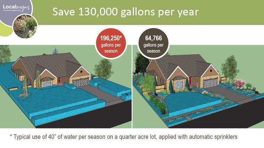
Farmington City Planning Commission Minutes 02.03.2022

Lagoon is looking to better promote the park for visitors coming off the freeway from the north with a new sign that would be
primarily visible to eastbound traffic along Park Lane. While a ground sign is a permitted use in the C-R zoning district, the Electronic
Message Sign component that allows for a changeable image requires a conditional use review by the Planning Commission.

The on premise sign is proposed to be located outside of the required clear view area near the intersection per Farmington City
Code (FCC) 15-3-030. The applicant has provided documentation from the sign company indicating that the sign meets the
specifications required from FCC 15-4-030 in that the sign can be programmed to turn off on a schedule and can dim according to set
specifications and/or ambient light conditions. It needs to shut off between midnight and 6 AM. It is towards the gas station and
Chevron and out of the clear view, meaning it will not obstruct the view of motorists in the intersection.

The Electronic Message Sign component is 8 feet by 4 feet in size (32 square feet) and there is another 10 square feet of fixed text
with the Lagoon logo. The signage is attached towards the top of a stone backdrop that stands just over 12 feet in height. The total
sign structure area including the stone wall and decorative metal lattice pillars on each side is 172 square feet. Based on the amount
of frontage and property of the park, dimensions of the sign are well within the 20 feet height allowance and 200 square feet sign
area permitted by the zoning ordinance and applicable zoning district. Staff recommends approval as proposed.

Applicant Adam Leishman (254 E. 200 South, Farmington, Utah) addressed the Commission. For 30 years, he has worked for
Lagoon. They have been noticing they get the most guests in the morning, which is leading to a traffic situation, especially on
Saturdays. The previous mayor asked them to fix it, or the Highway Patrol would fix it for them. Lagoon decided to try to fix it
themselves first. For many years, an additional entrance on the north off of Park Lane has been on the master plan. They are now
prepping the surface in the hopes permits go well. They have had positive interaction with the Utah Department of Transportation
(UDOT) and the City so far. This sign is intended to train guests about the additional entrance so they don’t have to turn left on
Lagoon Drive, which is causing a lot of traffic hold ups. The sign is a full RGB with no motion. It will have static images that shift.
The rock façade is an attempt to stay with the historical Farmington rock feel. They have asked UDOT for additional brown and
white signage. The sign will be turned off from 10 PM to 7 AM. The southbound traffic coming from Ogden, Kaysville, Layton, and
Idaho is a nightmare. They hope in the very near future to direct traffic at the north into what now looks like a vacant field into their
overflow parking. They would like it done this year. It would help traffic continue further east than they typically have in order to
enter the park.

Rulon Homer opened and closed the public hearing at 8:59 PM.

Gibson said the sign does not block line of site, and the static images won’t be as distracting as video animation. Findings are that it
should not be a traffic hazard.

MOTION

Erin Christensen made a motion that the Planning Commission grant approval to the applicant (Lagoon) for a Conditional Use for an
Electronic Message Sign as presented in this report, subject to all applicable Farmington City ordinances, development standards,
and building permit requirements.

Findings for Approval 1-4:

    1.   The sign is located in the Electronic Sign Area Overlay Zone.
    2.   The applicant has provided evidence from the sign manufacture to ensure that it will comply with the Electronic Message
         Sign standards of 15-4-060.
    3.   The location, height, and square footage dimensions of the sign are compliant with applicable ordinances.
    4.   Based on the sign’s location and surrounding uses, the minimum standards required by the ordinance are sufficient for
         mitigating reasonably anticipated detrimental impacts that may be caused by the Electronic Message component of the
         sign without the need for additional conditions.

Larry Steinhorst seconded the motion, which was unanimously approved.

OTHER BUSINESS

Item #5 Miscellaneous, correspondence, etc.

                                                                    5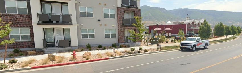
Farmington City Planning Commission Minutes 02.03.2022

    a.   Introduction to the Planning Commission Bylaws.
              a. Larry Steinhorst motioned to table 5a for another meeting. John David Mortensen seconded the motion, which
                  was unanimously approved. Homer said the commissioners have all read the new bylaws, and Gibson has
                  integrated any comments into the draft. It primarily addresses electronic meeting components.
    b.   Presentation of North Farmington Station Greenway Concept – STACK Real Estate. Trevor Evans, a representative of STACK
         Development, was online to present to the Commission. This was introduced in a prior work session with the City Council.
         Evans said the topic tonight is a greenway vs. a street, with the nexus being the City Park, which is about an 8-12 minute
         walk. According to market studies, the people who will live here and walk this greenway every day will be primarily young
         adults, young families, young professionals, and empty nesters needing to downsize. If a street is down the middle, that
         would be passive. The developers are trying to get a semblance of a back yard that is kid-friendly with a logical terminal of
         a park. Approaching Spring Street on the north is where the commercial would occur. The whole greenway is accessible to
         the public, but it becomes more private feeling to the south. There will be trails, pathways, grass areas, trees, and
         gathering benches. This greenway is critical to connecting the park to the mixed-use core. On Maker and Commerce roads,
         there are already connections for cars. Another road down the middle of the 500 acres becomes redundant. Evans is
         suggesting turning Center Street with a greenway instead. If this is a walkable community, it doesn’t make sense to allow
         the car to go everywhere.

         Gibson said anything colored salmon on the map is residential, including the Canopy product proposed by Wasatch. A
         mixed-use is proposed in the purple area. Evans said that Center Street was never an idea until later last fall, so the traffic
         study stands alone using Maker and Commerce. Center Street was never required, and would mostly be a local road that
         would not carry a lot of traffic. They will delve into more site plan details in the future. Petersen said this Center Street
         area was envisioned to be more like a Rio Grande Avenue at the Gateway, or Regent Street in Salt Lake, with slow-moving
         traffic. However, STACK doesn’t think that ground-floor retail will be a good option there, so cars may not be need to be
         accommodated.

         Christensen said as along as traffic doesn’t become bogged down elsewhere, this is a good idea. She wants to make sure
         traffic can get back and forth in the Wasatch areas appropriately. She likes that the greenway is unique and different.
         Steinhorst said he wants to make sure the bicycle path continues throughout the greenway corridor. Evans mentioned
         how City Creek took away from Gateway in Salt Lake, and they don’t want to create that with new Center Street
         commercial taking away from Station Park. The key component of retail is parking. Retailers won’t come if the parking
         ratios are not appropriate. North Station with its office and dense housing would have parking challenges. The viability of
         retail along that corridor is diminished because it is not the main traffic corridor, and it will not attract national anchors.
         There needs to be a focus on what is realistic and what the market will support.

         Petersen said the greenway doesn’t have to terminate at the park. It can continue beyond that into the office area. East-
         west vehicle traffic could still cross the north-south greenway in four places. Hansell said the plan that GSBS presented
         Tuesday night proposed parking infill. Retailers aren’t going to want to locate there, especially without a lot of parking.
         There is still a Project Master Plan (PMP) here that calls for 60% commercial/office. Evans said as the site plan is put in for
         the village core, the concept would be floated among brokers to test the demand. If the demand is higher, wrapping along
         Commerce and Maker would be considered. He doesn’t feel this would be a net reduction in commercial overall. It can’t
         be nailed down right now because there are no plans to show the market. Petersen said Catalyst’s marketing study was
         surprising because the retail was minimal, with the retail going by the interchange instead. The key take away here is the
         City likes the idea, but the other roads should work how they are supposed to work. Evans said they will look at it closer.
         That study was a high-level demographic of what could be done here, but diving deeper involves market demand that
         determines lease rates, etc.

ADJOURNMENT

Larry Steinhorst made a motion to adjourn at 9:34 PM. Sam Barlow seconded the motion, which was unanimously approved.

_________________________
Rulon Homer, Chair
                                                                    6
WORK SESSION: A work session will be held at 6:00 p.m. in Farmington City Hall, 160 South Main Street.
The public is welcome to attend. The agenda for the work session will be as follows:

        1.   CentryLink and Comcast Presentations

                            FARMINGTON CITY COUNCIL MEETING
                                  NOTICE AND AGENDA

       Notice is hereby given that the City Council of Farmington City will hold a regular City
Council meeting on Tuesday, February 15th, 2022, at 7:00 p.m. The meeting will be held at
the Farmington City Hall & electronically over Zoom for the public, 160 South Main Street,
Farmington, Utah.

Farmington City Council meetings, including this meeting, are open to the public. In consideration of the COVID-
19 pandemic, members of the public wishing to attend this meeting are encouraged to listen to the meeting on line.
The link to listen to the meeting live and to comment electronically can be found on the Farmington City website at
www.farmington.utah.gov. If you wish to email a comment for any of the listed public hearings, you may do so at
dcarlile@farmington.utah.gov.

The agenda for the meeting shall be as follows:

CALL TO ORDER:

7:00    Roll Call (Opening Comments/Invocation) Pledge of Allegiance

PRESENTATION:

7:05    Introduction of New City Councilmember and Administration of Oath of Office

7:10    Plaque Presentation to Outgoing Planning Commissioner Greg Wall

PUBLIC HEARING:

7:15    Consider a recommendation for a rezone of a property located at 1875 N 1075 W from
        Agricultural (A) to Large Residential (LR) for the proposed Monterra Subdivision, a
        four-lot subdivision.

NEW BUSINESS:

8:00    Amendment Number 2 to the Park Lane Commons Development Agreement

8:10    Settlement Agreement between Brent Wride and Farmington City regarding Greens
        Conservation Easement

SUMMARY ACTION:
(Items listed are considered routine in nature and will be voted on in mass unless pulled for separate discussion)
8:20   Minute Motion Approving Summary Action List

       1. Approval of Minutes for January 18th
       2. Approval of Minutes for February 1st
       3. Improvements Agreement with Schuchart Corporation for the Bank of America
          development.

GOVERNING BODY REPORTS:

8:25   City Manager Report

       1. Fire Department Monthly Activity Reports, November and December
       2. Building Activity Report for January

8:30   Mayor Anderson & City Council Reports

ADJOURN

CLOSED SESSION
Minute motion adjourning to closed session, if necessary, for reasons permitted by law.

*PLEASE NOTE: Times listed for each agenda item are estimates only and should not be
construed to be binding on the City Council.

In compliance with the Americans with Disabilities Act, individuals needing special
accommodations due to a disability, please contact DeAnn Carlile, City Recorder at
801-939-9206, at least 24 hours in advance of the meeting.

DATED this 10th day of February 2022.

                                     FARMINGTON CITY CORPORATION

                                     By: _________________________________
                                            DeAnn Carlile, City Recorder

I hereby certify that I posted a copy of the foregoing Notice and Agenda and emailed copies to
media representatives on February 10, 2022
Planning Commission Staff Report
February 17, 2022
______________________________________________________________________________
Item 3: Juniper Estates – Schematic Subdivision Plan
Public Hearing: Yes
Application No.: S-1-22
Property Address: Approx: 400 S. 650 W.
General Plan Designation: RR (Rural Residential)
Zoning Designation: AE (Agricultural Estates)
Area: 3.15 Acres
Number of Lots: 6
Property Owner: Mary Ann Burningham Trust
Agent: Phil Holland/Holland Group
Request: Applicant is requesting a recommendation for Schematic Subdivision plan for the proposed Juniper Estates
Subdivision.
______________________________________________________________________________
Background Information
The developer applied for a six-lot subdivision on 3.15 acres in an AE zone located at the above
referenced address. At its discretion the City may approve more than two lots, but such discretion is
limited to the options (or a possible combination of the options) set forth in the attached table
[note: the developer did not apply for the conventional alternative; however, this option is also
included in the table].
Suggested Motion
Move that that Planning Commission recommend the City Council approve the schematic
subdivision plan for the Juniper Estates Subdivision, Option ___ subject to all Farmington City
development standards and ordinances and approval of a Preliminary PUD Master Plan (if
necessary) and a preliminary plat and conditions and standards required thereto. All remaining City
standards, including but not limited to, the road alignment, whether or not the road is a public or
private street, total number of lots, the final lot configuration, including if lots will be allowed within
the r.o.w., DRC (Development Review Committee) comments, and so forth, will be determined
upon consideration of a Preliminary PUD Master Plan (if necessary) and a preliminary plat for the
project.
Supplemental Information
1. Vicinity Map
2. Schematic Subdivision Plan
3. Juniper Estates Additional Lot Options Table08-087-0012 08-087-0145 08-087-0188 08-087-0164
08-076-0009 08-087-0172 08-087-0119
08-087-0042 250 South 08-087-0077
08-195-0001
08-087-0159
649 W 08-087-0022 599 W 577 W 553 W 541 W 08-087-0161 587 W
08-087-0023 08-087-0019 08-087-0021 08-165-0002
08-195-0002
289 S 08-087-0050
way
08-449-0002 311 S 08-087-0051
314 S
08-218-0001 08-218-0002 08-218-0003 08-218-0010
345 S 596 W 576 W 558 W 536 W
08-087-0052
650 West
320 S
08-449-0004
Smoot Drive (350 South)
08-087-0154
369 S 08-087-0020 595 W 575 W 553 W
533 W
08-218-0008 08-218-0007 08-218-0006 08-218-0005
383 S
08-076-0010 08-218-0009
08-087-0074
08-087-0163
08-076-0110 417 S 08-087-0181
08-078-0064
08-077-0082 427 S 08-078-0049
424 S
08-077-0071 08-078-0102
650 West
08-077-0070
448 S
489 S 08-078-0024
08-077-0069
08-623-0702 08-578-0604
08-078-0087
08-554-0103
08-578-0603
08-578-0602 537 S
520 S
08-554-0104
08-623-0701
550 So
Disclaimer: This map was
0 75 150 225 300 produced by Farmington City
GIS and is for reference only.
VICINITY MAP Feet
The information contained on
this map is believed to be
accurate and suitable for
limited uses. Farmington City
Juniper Estates Meters
makes no warranty as to the
accuracy of the information
contained for any other
Date: 2/11/2022
0 10 20 30 40 purposes.JUNIPER ESTATES
REVISION
SCHEMATIC PLAN
PARCEL 080870074 GRAPHIC SCALE
30 0 15 30 60 120
(IN FEET)
1 inch = 30 ft.
DATE
LAND USE TABLE
NO.
TOTAL AREA = 3.08 ACRES
TOTAL LOTS = 6 LOTS
DRAWING IS NOT TO
AVERAGE LOT SIZE = 21,000 SF SCALE IF BAR DOES
NOT MEASURE 1 INCH
0 1/2 1
JUNIPER ESTATES
FARMINGTON CITY, DAVIS COUNTY, UTAH
SCHEMATIC PLAN
DETENTION/
RETENTION AREA
LOT 1 LOT 2 LOT 3 LOT 4 LOT 5
(66' PUBLIC ROW)
LOT 6
650 WEST
26,331 SF 21,678 SF 21,453 SF 21,229 SF 21,004 SF 22,769 SF
0.60 Acres 0.50 Acres 0.49 Acres 0.49 Acres 0.48 Acres 0.52 Acres
FIRE TURN AROUND
C:\Users\Scott\Google Drive\_Marketing\Phil Holland\Farmington - Juniper Estates\Farmington - Juniper Estates Concept.dwg Jan 04, 2022 - 2:01pm
28' SHARED ACCESS, UTILITY, DRAINAGE & SEWER EASEMENT
DESIGN: SPM
DRAWN: SPM
CHECKED: SRM
DATE: 4-25-21
SHEET:
C1Juniper Estates Additional Lot Options
February 17, 2022
Options Lots Comments Findings
Base Add- Total
itional
A Conventional 2 0 2 No additional lots
B TDR * 2 4 6 Six lots are possible, but the four additional lots must be TDR lots (Section The community benefits from the additional
11-10-040 B. 1. a. (1)) open space transferred off-site to the
regional park, or possibly elsewhere via a
cash payment acceptable to the City.
C Moderate 2 3 5 This alternative does not allow for six lots (unless the City determines it can This option is consistent with the moderate-
Income be used in combination with a TDR option), but five lots are possible income housing goals and objectives of the
Housing (Section 11-10-040 B. 1. b. (2)): City and the State.
Subdivider must provide or set aside lots (or dwelling units [i.e. ADUs, etc.]
at the option of the City) equal in number to at least ten percent (10%) of
the total number of lots approved for the subdivision for moderate income
housing.
Or
(a) A fee in lieu thereof determined in consideration of factors set forth in
Section 11-28-270 of this Title;
Or
(b) Some other public benefit;
Or
(c) A combination of (a) and (b) above.
D PUD** 5 1 6 This alternative may result in 5 lots, and one additional lot is possible so The base lot amount may be achieved by a
long as it is a TDR lot (11-27-120 G. 2. B.) 10% set aside in open space for the PUD, or
.315 acres. Arguably this is a small amount
and it may also be difficult for an HOA
consisting of just 5 or 6 lot owners to
maintain long-term; replacing the open space
through a TDR may be beneficial for the
community overall.
* Transfer of Development Right. “A transfer lot is a lot that could have been developed elsewhere in the City, but instead is platted in the place of proposed
conservation land, common area, or subdivisions using an alternative lot size, or as a special exception because of blight, and where money paid to the owner of
property located in a designated sending zone by a developer to transfer the lot, and increase the overall residential density of his project. Such lots shall be known and
referred to as "transfer lots" and must be approved by the City in conjunction with subdivision or site plan approval. A transfer lot is not the result of a waiver set forth
in this chapter.”
** Planned Unit DevelopmentPlanning Commission Staff Report
February 17, 2022
______________________________________________________________________________
Item 4: Kirkham Orchard – Final Plat
Public Hearing: No
Application No.: S-11-21
Property Address: Approximately 975 N Compton Rd (300 W)
General Plan Designation: LDR (Low Density Residential)
Zoning Designation: LR-F (Large Residential – Foothill)
Area: 2.455 Acres
Number of Lots: 5
Property Owner: Daniel Barton
Agent: Daniel Barton
Request: Applicant is requesting final plat approval for Kirkham Orchards subdivision.
______________________________________________________________________________
Background Information
Kirkham Orchard is a proposed subdivision located at approximately 1000 N Compton Rd. On November 4,
2021, the applicant requested schematic recommendation for 5 lots be created via subdivision, which required
a zone change for a small A-F portion to LR-F. A special exception was also being approved per 11-32-060
A.5, as the access to Lot 4 crosses Lot 5. The City Council approved the schematic subdivision and zone
change plans on November 16, 2021. Being that the applicant is conventionally subdividing his parcel, and
creating less than 10 lots, a preliminary plat was not a requirement prior to final plat review and approval (12-
5-020).
Suggested Motion
Move that that Planning Commission approve the final plat for the Kirkham Orchard subdivision - subject to
all applicable Farmington City ordinances and development standards, and all remaining DRC comments.
Findings for Approval:
1. The rezone, schematic subdivision plan, special exception and final plat are consistent with the
City’s General Land Use Plan and Zoning Ordinance.
2. The lot sizes proposed are similar to those of surrounding subdivisions and properties.
Supplemental Information
1. Vicinity Map
2. Final Plat08-055-0023 08-052-0210
08-052-0240 1085 N
08-052-0211
08-052-0214
08-052-0079 1067 N
08-052-0142
1058 N
08-052-0215
Compton Road (300 West)
08-052-0085 1037 N
08-052-0026
1033 N 1038 N
08-052-0081 08-052-0194
08-052-0046
08-052-0084
08-052-0032
1022 N
08-052-0266
286 W
08-052-0031
08-052-0082
1000 N
08-570-0003
08-052-0027
987 N
08-052-0043 08-052-0261 996 N
08-052-0044 975 N 08-570-0002
08-052-0042 08-052-0045
08-052-0083
08-570-0001
984 N
08-052-0145
961 N
960 N
08-052-0248
938 N
08-052-0088
08-052-0148
953 N 08-052-0249
08-052-0233
942 N
08-052-0182
Ma
in
Compton Road (3
Str
902 N 08-052-0246
ee
936 N
08-052-0093
(Ht
igh
08-052-0041
08-052-0040
wa
08-052-0253
y1
Disclaimer: This map was
0 50 100 150 200 produced by Farmington City
06
GIS and is for reference only.
VICINITY MAP Feet
The information contained on
)
00 West)
this map is believed to be
accurate and suitable for
limited uses. Farmington City
Kirkham Orchard Meters
makes no warranty as to the
accuracy of the information
contained for any other
Date: 11/1/2021
0 10 20 30 40 purposes.SURVEYOR'S CERTIFICATE:
VICINITY MAP
I, MICHAEL L. WANGEMANN, DO HEREBY CERTIFY THAT I AM A PROFESSIONAL LAND SURVEYOR,
KIRKHAM ORCHARD SUBDIVISION AND THAT I HOLD LICENSE N0. 6431156, AS PRESCRIBED UNDER THE LAWS OF THE STATE OF
LOCATED IN THE NORTHEAST QUARTER OF SECTION 13, UTAH. I FURTHER CERTIFY THAT BY AUTHORITY OF THE OWNERS, I HAVE MADE A SURVEY OF
THE TRACT OF LAND SHOWN ON THIS PLAT AND DESCRIBED HEREON, AND HAVE SUBDIVIDED
TOWNSHIP 3 NORTH, RANGE 1 WEST, SAID TRACT OF LAND INTO LOTS AND STREETS, TOGETHER WITH EASEMENTS, HEREAFTER TO BE
SALT LAKE BASE AND MERIDIAN KNOWN AS: KIRKHAM ORCHARD SUBDIVISION AND THAT THE SAME HAS BEEN CORRECTLY
FARMINGTON CITY, DAVIS COUNTY, UTAH SURVEYED AND MONUMENTED ON THE GROUND AS SHOWN ON THIS PLAT.
DECEMBER 2021
SITE
FOUND BRASS CAP MONUMENT
NORTHEAST CORNER, SECTION 13,
TOWNSHIP 3 NORTH, RANGE 1 WEST, MICHAEL L.
SALT LAKE BASE AND MERIDIAN 30 0 15 30 60 90 WANGEMANN
No. 6431156
FOUND INTERSECTION MONUMENT
1747.08 POB TIE
CURTIS KIRKHAM ( IN FEET )
388.90'
TAX ID NO. 08-052-0026 1 inch = 30 ft. DATE: MICHAEL L. WANGEMANN
LICENSE NO. 6431156
S88°40'25"E 426.48' LEGEND
132.66'
POINT OF BEGINNING
123.58'
170.24'
N88°40'25"W 609.28 BOUNDARY DESCRIPTION
30.00 SECTION CORNER
BEGINNING AT A POINT ON THE WEST RIGHT-OF-WAY LINE OF COMPTON ROAD, SAID POINT BEING
10' P.U.D.E. NEW STREET MONUMENT SOUTH 00°17'00” WEST (RECORD=SOUTH 00°11'50” WEST) ALONG THE SECTION LINE 1747.08 FEET AND
(TYP.)
S00°43'03"W 577.18'
NORTH 88°40'25” WEST 609.28 FEET FROM THE NORTHEAST CORNER OF
(FOUND) WITNESS CORNER SECTION 13, TOWNSHIP 3 NORTH, RANGE 1 WEST, SALT LAKE BASE AND MERIDIAN; AND RUNNING THENCE
10' P.U.D.E.
SOUTH 00°43'03” WEST ALONG SAID WEST RIGHT-OF-WAY LINE 188.59 FEET TO THE POINT ON A 4579.59 FOOT
- XXXX NORTH -
(TYP.) PUBLIC UTILITY AND
P.U.D.E RADIUS CURVE; THENCE SOUTHERLY ALONG THE ARC OF SAID CURVE TO THE LEFT 12.69 FEET AND THROUGH
DRAINAGE EASEMENT
87.56'
A CENTRAL ANGLE OF 00°09'32” (WHICH LONG CHORD BEARS SOUTH 00°38'17” WEST 12.69 FEET); THENCE
LOT 1
85.00'
PROPERTY CORNER SET WITH 58" ALONG THE NORTH, WEST AND SOUTH SIDES OF THE NOORDA PROPERTY THE FOLLOWING
14,126 SQ. FT. REBAR & PLASTIC CAP STAMPED THREE (3) COURSES: NORTH 85°55'43” WEST 120.31 FEET; THENCE SOUTH 01°32'50” WEST 70.00 FEET; THENCE
0.32 Acres SOUTH 78°45'59” EAST 124.24 FEET TO SAID WEST RIGHT-OF-WAY LINE AND A POINT ON SAID 4579.59 FOOT
LOT 3 "UTAH LAND SURVEYING"
SHARED PRIVATE ACCESS, DRAINAGE AND
RADIUS CURVE; THENCE SOUTHERLY 83.93 FEET ALONG THE ARC OF SAID CURVE TO THE LEFT THROUGH A
CENTRAL ANGLE OF 01°03'00” (WHICH LONG CHORD BEARS SOUTH 01°02'16” EAST 83.93 FEET); THENCE
S21
21,780 SQ. FT.
UTILITY EASEMENT IN OWNED AND NORTH 77°02'05” WEST 311.02 FEET; THENCE NORTH 21°27'56” WEST 334.09 FEET; THENCE
S6°48'13"E
0.50 Acres
° 27
MAINTAINED BY KIRKHAM ORCHARD
164
SOUTH 88°40'25” EAST 426.48 FEET TO THE POINT OF BEGINNING.
SUBDIVISION HOME OWNERS ASSOCIATION
' 56
.44
CONTAINS 112,045.06 SQ/FT OR 2.57 ACRES.
S00°43'03"W 188.59'
"E
'
S89° 16' 57"E
OWNERS DEDICATION:
181.23'
167.80'
158.77'
188.28'
WE, THE UNDERSIGNED OWNERS OF THE HEREON DESCRIBED TRACT OF LAND, HEREBY SET
APART AND SUBDIVIDE THE SAME INTO LOTS AND STREETS AS SHOWN ON THIS PLAT, AND NAME
SAID TRACT:
(S00°11'50"W 2650.40')
S00°17'00"W 2649.51'
- XXXX NORTH -
NOTES:
1. APPROVAL OF THIS DEVELOPMENT PLAT BY FARMINGTON CITY KIRKHAM ORCHARD SUBDIVISION
COMPTON ROAD
80.24'
(60' RIGHT OF WAY)
LOT 2 DOES NOT CONSTITUTE ANY REPRESENTATION AS TO THE
AND DO HEREBY DEDICATE, GRANT AND CONVEY TO FARMINGTON CITY, DAVIS COUNTY, UTAH,
N21
88.23'
ADEQUACY OF THE SUB-SURFACE SOIL CONDITIONS NOR THE
12,856 SQ. FT. ALL THOSE PARTS AND PORTIONS OF SAID TRACTS OF LAND DESIGNATED AS PUBLIC ROADS,
LOCATION OR DEPTH OF GROUND WATER TABLES.
°27
0.30 Acres THE SAME TO BE USED AS PUBLIC UTILITY AND DRAINAGE EASEMENTS FOREVER AS SHOWN
2. INDIVIDUAL PROPERTY OWNERS ARE RESPONSIBLE FOR
HEREON, THE SAME TO BE USED FOR THE INSTALLATION, MAINTENANCE AND OPERATION OF
'56"
334
SURFACE DRAINAGE FROM THEIR LOTS. THE CITY WILL INSPECT
FLO ID NO
PUBLIC UTILITY SERVICE LINES AND DRAINAGE AS MAY BE AUTHORIZED BY FARMINGTON CITY.
TAX
FINAL GRADES TO ENSURE COMPLIANCE WITH THE SUBDIVISION
.09
W3
RE
10' P.U.D.E. GRADING PLAN PRIOR TO HOME OCCUPANCY PERMIT BEING
'
- XXX EAST - - XXX EAST - IN WITNESS WHEREOF, WE HAVE HEREUNTO SET OUT HANDS THIS _______________________ DAY
34 .
(TYP.) ISSUED.
NC 08-05
09'
S5 3. A SOIL REPORT HAS BEEN PREPARED AND SUBMITTED TO THE
S85°55'43"E 14 OF _________________________ A.D. 20____.
E
7° 8.52' CITY FOR THE PROPOSED SUBDIVISION IN ACCORDANCE WITH THE
.
00
S. H 2-008
03 '
LOT 4 -X
XX
79
.57 "E
IVE PRIVATE DR 28.05' PROVISIONS OF THE SUBDIVISION ORDINANCE.
4. YARD INFILTRATION SWALES WILL BE INSTALLED BY THE
ESS 4
' SHARED ACCES
53,195 SQ. FT. EA S, PUBLIC UTILI
TY, DEVELOPER AND MAINTAINED BY THE HOME OWNERS.
ST DRAINAGE & SE 30.05'
7.05'
1.22 Acres S85° 55' 43"E WER EASEMEN 5. 5/8" REBAR AND CAP WILL BE SET IN ALL PROPERTY CORNERS.
- T
TRU
6. GARBAGE PICK UP SERVICE BE PROVIDED ON COMPTON ROAD.
44.43'
CORPORATE ACKNOWLEDGEMENT:
ST
10' P.U.D.E. N85°55'43"W 12
(TYP.) 0.31'
STATE OF UTAH) §
ARC=12.69' COUNTY OF DAVIS
S1°32'50"W 70.00'
RADIUS=4579.59'
DELTA=00°09'32" ON THIS ______DAY OF _____________, IN THE YEAR 20______, PERSONALLY APPEARED BEFORE
70.00'
S00°51'46"W 26 51.04')
50.02' ME______________________ , WHOSE IDENTITY IS PERSONALLY KNOWN TO ME (OR PROVEN ON
ING
CHORD=S00°38'17"W
CHORD DIST=12.69' THE BASIS OF SATISFACTORY EVIDENCE) AND WHO BY ME DULY SWORN/AFFIRMED, DID SAY
DAVID J. & LUCY C. NOORDA
BASIS OF BEAR
(S00°46'35"W 26
THAT HE/SHE IS THE ___________________________ OF ____________________________ AND
TAX ID NO. 08-052-0027 THAT SAID DOCUMENT WAS SIGNED BY HIM/HER IN BEHALF OF SAID *CORPORATION BY
AUTHORITY OF ITS BYLAWS, OR (RESOLUTION OF ITS BOARD OF DIRECTORS), AND SAID
_______________________________ACKNOWLEDGED TO ME THAT SAID *CORPORATION EXECUTED
THE SAME.
S78°4 WITNESS MY HAND AND OFFICIAL SEAL.
PRIVATE 15' SEWER 5'59"E
EASEMENT IN FAVOR 124.24
'
OF LOT 3 AND 4 124.24 __________ ____________________
'
(NOTARY SIGNATURE)
CORPORATE ACKNOWLEDGEMENT:
N1° 32' 50"E
79.25'
ARC=83.93' STATE OF UTAH) §
RADIUS=4579.59' DELTA=01°03'00" COUNTY OF DAVIS
- XXXX NORTH -
182.2
LOT 5 CHORD=S01°02'16"E
ON THIS ______DAY OF _____________, IN THE YEAR 20______, PERSONALLY APPEARED BEFORE
2' CHORD DIST=83.93'
10,087 SQ. FT. ME______________________ , WHOSE IDENTITY IS PERSONALLY KNOWN TO ME (OR PROVEN ON
0.23 Acres (N89°07'41"E 26.80') THE BASIS OF SATISFACTORY EVIDENCE) AND WHO BY ME DULY SWORN/AFFIRMED, DID SAY
N89°29'43"E 26.80 THAT HE/SHE IS THE ___________________________ OF ____________________________ AND THAT
FARMI N77° SAID DOCUMENT WAS SIGNED BY HIM/HER IN BEHALF OF SAID *CORPORATION BY AUTHORITY OF
NGTO 02'05 NOT FOUND MONUMENT
RIGHT N CITY "W 31 ITS BYLAWS, OR (RESOLUTION OF ITS BOARD OF DIRECTORS), AND SAID
OF WA 1.02' EAST QUARTER CORNER, SECTION 13,
Y TOWNSHIP 3 NORTH, RANGE 1 WEST, _______________________________ACKNOWLEDGED TO ME THAT SAID *CORPORATION EXECUTED
128.8 SALT LAKE BASE AND MERIDIAN THE SAME.
0'
(S01°23'00"W 16.04')
BASIS OF BEARINGS: S01°33'27"W 16.04' WITNESS MY HAND AND OFFICIAL SEAL.
DELTA=04°54'31"
RADIUS=4549.59
PRIVATE 15' SEWER
ARC=389.77
A BEARING OF SOUTH 00°51'46" WEST BETWEEN DAVIS COUNTY EASEMENT IN FAVOR S88°26'14"W __________ ____________________
MONUMENT REPRESENTING THE NORTHEAST CORNER OF SECTION OF LOT 3 AND 4 30.00 FOUND 6" PIPE FILLED WITH CEMENT (NOTARY SIGNATURE)
13, TOWNSHIP 3 NORTH, RANGE 1 WEST, SALT LAKE BASE & DANIEL BARTON
975 NORTH COMPTON ROAD FOUND BRASS CAP WITNESS CORNER MONUMENT
MERIDIAN, AND DAVIS COUNTY MONUMENT REPRESENTING THE
TO THE EAST QUARTER CORNER, SECTION 13, DAVIS COUNTY RECORDER
WITNESS CORNER TO THE EAST QUARTER CORNER OF SECTION 13, BARTON@ADOBE.COM TOWNSHIP 3 NORTH, RANGE 1 WEST,
WAS USED AS THE BASIS OF BEARINGS FOR THIS SURVEY. (801) 809-7753 ENTRY NO. FEE PAID
SALT LAKE BASE AND MERIDIAN
FILED FOR RECORD AND RECORDED THIS DAY OF , 20___
CENTRAL DAVIS SEWER DISTRICT BENCHLAND WATER DISTRICT CITY ENGINEER'S APPROVAL CITY ATTORNEY APPROVAL PLANNING COMMISSION CITY COUNCIL ACCEPTANCE AT IN BOOK PAGE .
APPROVED THIS______DAY OF__________ A.D., APPROVED THIS______DAY OF__________A.D., 20___ APPROVED THIS_______DAY OF_________A.D., 20___ APPROVED THIS_________DAY OF______A.D., 20___
20___
APPROVED THIS _________DAY OF_______A.D., 20___ APPROVED THIS_______DAY OF__________A.D., 20___ BY THE FARMINGTON CITY PLANNING AND ZONING BY THE FARMINGTON CITY COUNCIL.
DAVIS COUNTY RECORDER
BY THE CENTRAL DAVIS SEWER DISTRICT. BY THE BENCHLAND WATER DISTRICT. BY THE FARMINGTON CITY ATTORNEY. COMMISSION. _______________________
BY THE FARMINGTON CITY ENGINEER.
MAYOR
______________________ _______________________ BY:
______________________ ______________________ _______________________ _______________________
CHAIRMAN DEPUTY RECORDER
CITY ENGINEER CITY ATTORNEY CHAIRMAN CITY RECORDERPlanning Commission Staff Report
February 17, 2022
______________________________________________________________________________
Item #5: Zone Text Amendment—Amendments to Multiple Sections of Title 11 of the City
Ordinances to Enact Water Efficient Landscaping Requirements.
Public Hearing: Yes
Application No.: ZT-2-22
Applicant: Farmington City
Request: Staff is proposing changes to Title 11 in order to enact requirements for Water Efficient Landscaping in certain new
development and significant redevelopment projects.
______________________________________________________________________________
Background Information
As the Wasatch Front has been experiencing several years of drought, Weber Basin Water Conservancy District, which
facilitates the delivery of a large majority of culinary and secondary water throughout Weber and Davis County, has asked that
cities participate in water conservation efforts by requiring more water efficient landscapes with new projects.
In August of 2021 this idea was first introduced to the Planning Commission. A public hearing was held, however because of
the significant lapse in time a new hearing has been noticed. In August the Commission asked that this be delayed to be
further studied in preparation for spring.
Staff has worked with Weber Basin Water Conservancy on the proposed ordinance to ensure the proposal will satisfy their
target goals and requirement to make existing Farmington City residents and businesses eligible for rebates to encourage
retrofitting their landscaping through the ‘Flip Your Strip’ program.
Key highlights of the proposed ordinance are:
- Park-strips in new development would no longer be allowed to have grass.
- Park-strips in existing areas would be eligible for incentives to have grass removed.
- Larger landscaped areas would be limited to the amount of grass allowed.
The ordinance as prepared has been greatly simplified from the original proposal in order to be better administered by city
staff
Suggested Motion
Move that the Planning Commission make a recommendation to the City Council to approve the proposed zone text
amendments.
Findings
1. This ordinance is designed to prevent water from being wasted on irrigated landscapes in new developments.
2. Upon approval of the ordinance by the City Council, residents will be eligible to participate in the ‘Flip your
Strip’ program further saving water by incentivizing retrofits to existing landscapes.
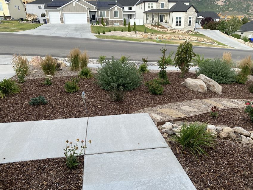
1Supplementary Information
1. Weber Basin Water Draft Ordinance Amendment – 11-3-030
2. Flip Your Strip Program Details
3. Localscapes plan example
4. Localscapes water use graphic
5. Local water efficient landscaping examples
2FARMINGTON CITY, UTAH
ORDINANCE NO. ___________
AN ORDINANCE AMENDING MULTIPLE SECTIONS OF TITLE 11, ZONING
REGULATIONS, OF THE FARMINGTON CITY ORDINANCES REQUIRING WATER
EFFICIENT LANDSCAPING.
WHEREAS, the Planning Commission has held a public hearing in which the Water Efficient
Landscape Ordinance was discussed and the Planning Commission recommended that these
changes be approved by the City Council; and
WHEREAS, the Farmington City Council has also held a public hearing pursuant to notice
and as required by law and deems it to be in the best interest of the health, safety, and general
welfare of the citizens of Farmington to make the changes proposed;
NOW, THEREFORE, BE IT ORDAINED BY THE CITY COUNCIL OF
FARMINGTON CITY, STATE OF UTAH:
Section 1. Amendment. Multiple sections of Title 11 of the Farmington City Zoning
Ordinance are hereby amended as set forth in Exhibit “A” attached hereto and by this reference
made a part hereof.
Section 2. Severability. If any provision of this ordinance is declared invalid by a
court of competent jurisdiction, the remainder shall not be affected thereby.
Section 3. Effective Date. This ordinance shall take effect immediately upon
publication or posting or 30 days after passage by the City Council, whichever comes first.
PASSED AND ADOPTED by the City Council of Farmington City, State of Utah, on this
1st day of February 2022.
FARMINGTON CITY
Brett Anderson, Mayor Pro Tem
ATTEST:
___________________________
DeAnn Carlile, City Recorder
1You can also read