MAKING CONNECTIONS Planning parks and open space networks in urban neighbourhoods
←
→
Page content transcription
If your browser does not render page correctly, please read the page content below
MAKING
            Planning parks and
            open space networks in
            urban neighbourhoods

CONNECTIONS
     – 1–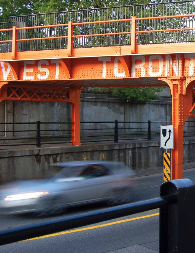
What we’re all about:

Toronto Park People is an independent charity that
brings people and funding together to transform
communities through better parks by:

CONNECTING a network of over                    RESEARCHING       challenges and
100 park friends groups                         opportunities in our parks

WORKING     with funders to support             HIGHLIGHTING the importance
innovative park projects                        of great city parks for strong
                                                neighbourhoods

ORGANIZING    activities that bring
people together in parks                        BUILDING    partnerships
                                                between communities and the
                                                City to improve parks

Thank you to our funders for
making this report possible:

                                                                                 The Joan and Clifford
                                          The McLean Foundation
                                                                                  Hatch Foundation

Cover Photo: West Toronto Railpath. Photographed by Mario Giambattista.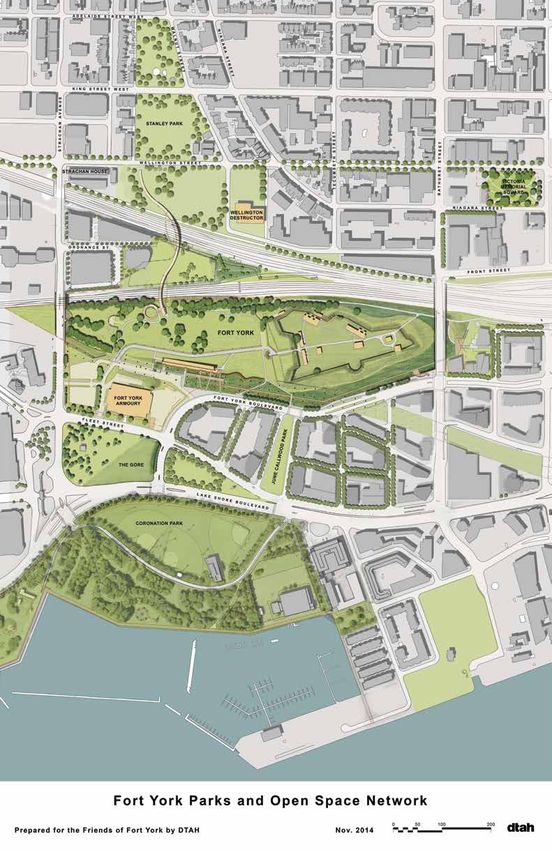
TABLE OF CONTENTS

Executive Summary.........................................................4
Introduction.....................................................................7
Planning for a network of parks and open spaces.......9
What are we doing in Toronto?.................................... 12
      The downtown challenge........................................ 15
      The current park system downtown....................... 17

8 Guiding Principles                                                                 Opportunities in Downtown Toronto......................40
For Creating a Connected Parks and Open Space                                        Garrison Creek Greenway............................................ 41
System in Urban Neighbourhoods..........................20
                                                                                     The Green Line..............................................................42
                                                                                     Cloud Gardens and Temperance Street.....................43

  1
         Proactively plan central green spaces
         as the heart of open space networks ...............21                       Cumberland Corridor...................................................44
                                                                                     Downtown Yonge laneways..........................................45
  2      Create green connections that
         become places themselves................................23                  Residential green laneways..........................................46
                                                                                     Yonge Street Park.......................................................... 47
  3      Be flexible in design and use.............................26
                                                                                     College Park...................................................................48
         Broaden the park to include
 4       the space beyond its edges...............................28

         Find park space in overlooked and
 5       unexpected places.............................................. 31
                                                                                     Focus on Greater Fort York: A Model for Building

 6
         Empower communities by building                                             a Successful Parks and Open Space System..............49
         new partnership models.....................................33
                                                                                     Recommendations........................................................53

 7       Experiment and be nimble................................36                  Sources...........................................................................57

 8
         Create collaborations and pool
         funding sources...................................................38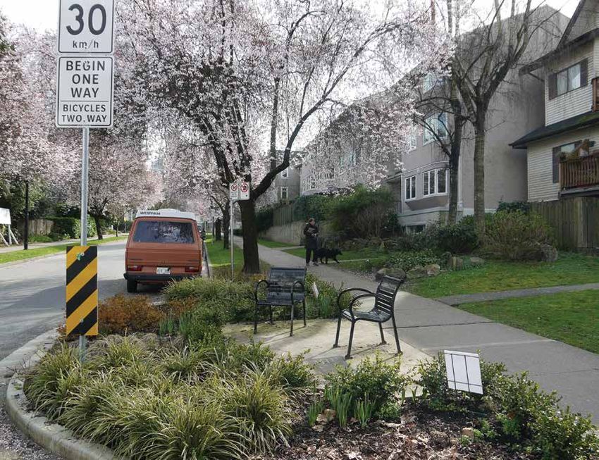
Executive Summary
As many Toronto neighbourhoods continue to develop and
intensify, the need for an expanded and improved parks and
open space system grows.

Meeting this need, however, is increasingly                     •   Encouraging flexibility and experimentation both
challenged by high land prices, limited space,                      in designs and funding as well as in how
and pressures from high and diverse use. While a                    we engage with communities.
number of creative ideas are emerging in Toronto
to tackle these challenges, Toronto needs an overall
framework and plan for creating a connected system              Underpinning all of this is the need to make
of parks and open spaces. This requires a shift from            connections— connections between different types
thinking about parks as isolated green spaces to                of parks and open spaces, between communities and
planning them as the heart of a network of diverse              partners in those spaces, and between city divisions
open spaces that serve many needs.                              and resources.

This report highlights tools and strategies for                 These connections can also help bridge divides by
planning parks and open space systems that are                  linking communities. They increase access to parks
emerging in North America in response to the                    and open spaces through our hydro corridors and
challenges presented by growth and densification.               ravines as well as our streets, laneways, and trails.
                                                                Traditional parks and green spaces remain the core
A proactive plan for a network of parks and open                of this network, and acquiring land for new ones is
spaces must be green, creative, flexible, and locally           crucial, but making connections is what creates a true
responsive. It requires:                                        system of parks and open spaces.

•   Reframing how we view different open spaces,                We can learn from others, such as San Francisco’s
    such as streets, sidewalks, schoolyards, laneways,          Green Connections plan, which aims to connect
    trails, and courtyards, to understand how                   parks through green corridors, or Vancouver’s West
    they complement and connect with parks and                  End Community Plan, which looks to laneways and
    facilitate movement within the system.                      streets to build new green spaces and links. But we
                                                                can also learn from Toronto examples, such as the
•   Creating proactive plans that not only identify             Garrison Creek Linkage Plan, which proposed a set
    where to buy new parkland but coordinate the                of networks between parks along the Garrison Creek
    work of city divisions around a community-                  corridor, and the planning work done for the green
    driven vision of a connected parks and open                 space system now emerging around Fort York.
    space system.

                                                         – 4–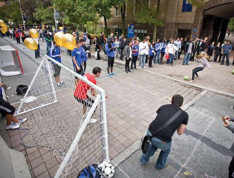
Or through projects like the West Toronto Railpath
and the John Street Cultural Corridor, which create
new connections and public spaces along a rail
corridor and street, respectively.

Through exploring these and many more examples,
we propose eight guiding principles for creating
connected parks and open space systems in urban
neighbourhoods to help guide the creation of a
Toronto framework.

                                                             A trail through Birkdale Ravine

    1                            2                             3                                4
Proactively plan central     Create green connections         e flexible in design and
                                                             B                                 Broaden the park to
green spaces as the heart    that become places              use so that the space             include the space
of networks that connect     themselves and can act as       we have can be used               beyond its edges so
many different forms of      links between larger parks      efficiently and adapt to          that parks and green
open spaces.                 and open spaces.                changing needs.                  space spill out into our
                                                                                               streets and sidewalks.


    5                            6                             7                                 8
 ind park space
F                            Empower communities by          Experiment and be                 Create collaborations
in overlooked and            building new partnership        nimble by employing                and pool funding
unexpected places such       models that allow for           quick designs to test              sources to bring
as schoolyards and under     more local decision-            ideas and gather                   multiple city divisions
overpasses.                  making and programming          feedback.                          on board and find
                             to meet diverse needs.                                             new money for park
                                                                                               improvements.


                                                      – 5–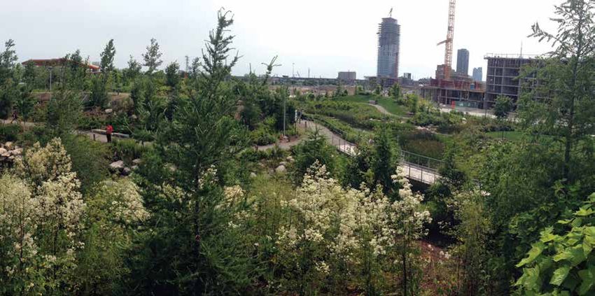
Corktown Common

In particular, we look at how to bring this thinking           In order to embrace these emerging ideas in Toronto,
to downtown Toronto given its explosive growth                 we must ensure we have the staff resources to
and its unique challenges, including a flood of new            carry out the proactive planning and community
residents, intense and fast-paced development, and             engagement work needed. We should also explicitly
expensive land. These challenges have led to little            include opportunities to convert streets and laneways
new park space being created to serve this new                 to parks and plazas within our parks planning and
population, putting pressure on existing parks. New            acquisition strategies and explore the use of Section
parkland must be purchased, but it must be planned             42 park levies to help build these connections and
as part of an overall connected system.                        new open spaces. And we need to act more quickly,
                                                               experimenting with pilot projects to ensure open
There are many opportunities to apply creative                 space improvements can occur sooner rather than
solutions for downtown to improve and expand the               later. In short, we must be proactive, creative, flexible,
parks and open space system by applying these 8                and locally responsive to create a parks and open
principles. For example, we can create new social              space system that can meet the diverse needs of
gathering spaces and green linkages in residential             Toronto’s neighbourhoods.
and commercial laneways, as well as along bike
corridors such as Shaw Street, which connect many
parks together. We can also connect community
members through new models for park programming
and operations to help animate centrally located
parks, such as College Park and Allan Gardens. And
we can employ flexible designs across multiple open
spaces to create new public space corridors that
build off existing parks such as Village of Yorkville
Park, Cloud Gardens, and a redesigned Yonge Street.

                                                        – 6–
Introduction
Our city is growing. With this growth comes the need to expand and
improve our parks and open spaces to serve new diverse residents
—a need that becomes increasingly challenging to meet as Toronto
continues to develop and intensify.

                                                                 Between 2009 and 2013, 86% of proposed new
                                                                 residential units were located in neighbourhoods
                                                                 designated for intensification, which includes the
                                                                 downtown, other centres such as Yonge-Eglinton,
                                                                 and the avenues.1

                                                                 As neighbourhoods become denser, pressures on
                                                                 the park system grow if new spaces don’t keep pace.

                                                                 To meet these challenges, we need to reframe
                                                                 the discussion about parks to include a broader
Other North American cities are also struggling                  view of our entire system of open spaces. Parks
with these same challenges. Many of them have                    cannot be planned as isolated green islands within
developed proactive plans and strategies to                      the city. Instead, our parks should flow through
address parks and open space needs by focussing                  our neighbourhoods and connect with each other
on green connections, flexible designs, community                through a variety of open spaces that serve
involvement, and creative solutions. We can draw                 different needs.
lessons from these cities, as well as from some of
the innovative projects emerging in Toronto, to                  While traditional green spaces must remain at
understand the elements needed for a new way of                  the heart of our communities, and focus must be
planning parks and open space systems.                           sharpened on acquiring land and planning for more
                                                                 of them, they must be placed within this context of a
This new way must focus on making connections—                   wider open space system.
connections between different types of parks and open
spaces, between communities and partners in those
spaces, and between city divisions and resources.

While felt across many communities in Toronto, the
challenge of meeting parks and open space needs
becomes more acute in denser neighbourhoods, where
acquiring new land for parks is hampered by high
growth, expensive land, and increasingly limited space.

                                                          – 7–
Some of these spaces may not resemble traditional
parks. Some are found on streets, sidewalks,
schoolyards, and laneways. Some are green, while
others are hard surface plazas. Some are filled with
community programming, others are quiet or support
nature and biodiversity. Some provide opportunities
to rest and linger, while others provide connections
for pedestrians and cyclists between green spaces.
But they all serve the purpose of creating a more
connected, diverse, and beautiful public realm.

                                                                Toronto ravine                                Rebecca Alam
“Toronto’s public realm—its streets,
 parks and open spaces—are its                                  First, we propose a set of eight guiding principles for
 shared outdoor rooms where                                     planning parks and open space networks in denser,
                                                                urban neighbourhoods. These principles are based
 our civic life takes place.”
                                                                on emerging directions in Toronto and in other North
City of Toronto, Privately-Owned Publicly
Accessible Spaces Design Guidelines, 2014 2                     American cities. We then focus on the unique and
                                                                immediate challenges facing downtown Toronto
Key to this is putting the time and resources in place          neighbourhoods, and how these principles could
to plan proactively and build community partnerships            work on the ground.
to help animate and care for parks, ensuring they
keep up with diverse needs. And we need to be                   With the start of TOCore and the update to the
more flexible and open to experimentation in how                almost 15 year-old citywide parks acquisition strategy,
we design and fund this network of open spaces,                 the moment to have this conversation is now. TOCore
coordinating the work of different city divisions               was initiated by City Planning and brings multiple
around this goal.                                               city divisions together to create a much-needed
                                                                downtown plan, including parks and the public realm.
This paper highlights some of the tools and                     This study was announced in 2014 and is projected to
strategies to help begin this conversation in Toronto.          finish in 2017. It is a major undertaking that will involve
It is not a prescriptive master plan that maps out              much discussion.
exactly what should occur on what specific piece of
land. That work must be done through consultation               We hope the ideas presented here can help frame
with communities.                                               and inform that discussion, provoke debate, and
                                                                highlight some of the opportunities that shouldn’t
                                                                be overlooked for creating a more connected system
                                                                of parks and open spaces.

                                                         – 8–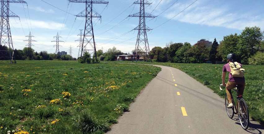
Planning for a network of parks
and open spaces
Thinking about parks and open space systems is as old as North
American parks themselves.

Frederick Law Olmsted (1822 – 1903), most famous                Creating such a system in today’s built-up cities,
as the designer of New York’s Central Park, was not             especially their downtowns, is a much different
only interested in creating pastoral parks, but park            task than in Olmsted’s time. Today we have
systems. He did this partly through parkways—low-               more development, fewer vacant land parcels,
volume roads lined with greenery that strung parks              streets oriented toward the car, and park systems that
along them. One of the best examples of this is                 may have developed opportunistically in increments
Boston’s Emerald Necklace, connecting six parks                 rather than through a comprehensive plan.
along 11 kilometres.
                                                                In these environments, it’s necessary to understand
“Parks are critical to the development                          how the wider open space system of streets,
 of new neighbourhoods and we                                   laneways, privately-owned public spaces, hydro and
                                                                rail corridors, cemeteries, schoolyards, trails, and
 design communities so that parks
                                                                other pedestrian spaces complement our parks. This
 and public spaces are their spines.”                           is not about relegating traditional parks to a lesser
Waterfront Toronto3                                             role—these core green spaces are the heart of a
                                                                healthy park system—but placing them within a
Building connections between existing parks, and                larger network.
understanding how the spaces in-between act
as connective tissue, can help extend their reach               Physical space isn’t the whole story, though, and
and add to the diversity of open space in the city.             quantity shouldn’t be the only way we measure the
Filling in the gaps, as Toronto Chief Planner Jennifer          success of our parks and open space systems.
Keesmaat recently noted, multiplies “exponentially
the amount of benefit you provide to adjacent                   As Peter Harnik writes in his book Urban Green, “It’s
neighbourhoods” by increasing people’s access                   not the acreage or park type standard that should
to parks.4                                                      motivate cities, but the direct awareness of the need”
                                                                for different kinds of parks and activities. Instead
                                                                of setting a standard to measure against, such as
                                                                certain number of hectares per 1,000 people, he
                                                                recommends cities “devise a process for meeting
                                                                the need for picnicking, walking, bench-sitting,
                                                                bird-watching, cycling, kite-flying, and more in each
                                                                specific community.”5

                                                         – 9–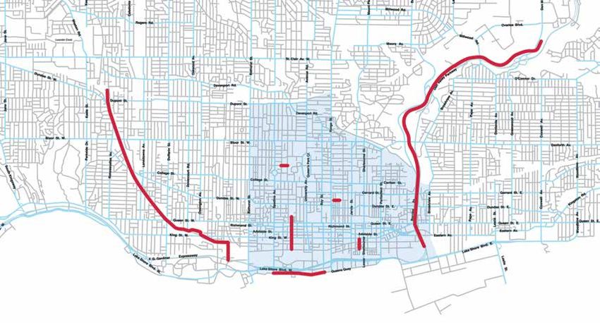
Finch Hydro Corridor Trail

In other words, what’s important is understanding          “[S]idewalk gardens, intersection islands, street parks,
how people want to use their parks and open spaces          and play streets,” the plan noted, “can provide
and devising a plan to meet those desires. This may         a backdrop for people to meet, gather, stroll, sit,
mean obtaining new spaces, but it also may mean             play, exercise, and meditate. In a dense city such
using existing spaces in new and different ways,            as San Francisco, these small-scale interventions
establishing new connections between parks and the          can go a long way in building cohesive, livable
people that use them, and thinking about how the            neighborhoods.”6
parks and open space system functions as a whole.
                                                               New York’s PlaNYC argued that “because the
This requires creative thinking, community                     supply of vacant land and capital budgets are both
involvement, and different city departments—                   finite, creating new parks will require creative new
not just already stretched-thin parks departments—             strategies.”7 Some of these strategies included
working together.                                              reusing streets as parks, building parks on landfills,
                                                               and redesigning schoolyards to serve as community
For example, San Francisco’s 2014 Green                        park spaces.
Connections, a plan to link parks together through
pleasant cycling and walking routes, was a                     Other creative ideas are found within Vancouver’s
partnership between planning, transportation, public           recent community plans for the West End, Downtown
health, and community-based organizations. The                 Eastside, and Mount Pleasant neighbourhoods.
plan outlined traffic calming techniques, landscaping,         These plans identified opportunities such as green
green infrastructure, and community stewardship                linkages in laneways, new plazas or park spaces on
opportunities to accomplish this goal.                         streets and lots, and improvements to existing parks.

                                                      – 10 –
New York’s High Line Park San Francisco’s Annie Alley Sergio Ruiz for SPUR
Closer to Toronto, the City of Mississauga, which
is experiencing an intensification of its downtown,
noted in its 2014 parks master plan that creating new
large parks would be difficult. Smaller “infill” green
spaces can “contribute to a connected network of
green spaces,” the report said, adding that these
spaces “will likely play a greater role in the future in
ensuring continued access to park-like places that
fulfill the expanded role of parks and green spaces.”8
Some cities have begun to experiment with different
types of “infill” open spaces. For example, the last
City Hall Rooftop Garden six years has seen the amount of street-to-parks
programs multiply, with cities inserting new parks and
plazas onto streets. Take San Francisco’s now famous
“parklet,” part of the Pavement to Parks program
launched in 2009, or New York City’s Plaza Program,
where organizations apply to convert under-utilized
roadway into new plazas. These have spawned similar
programs in Los Angeles, Philadelphia, Vancouver,
Seattle, and many other cities.
What these share in common are a commitment to
carrying out a proactive plan and thinking creatively
to shape the future parks and open space system of
urban neighbourhoods.
– 11 –What are we doing in Toronto?
The park system in Toronto is over 8,000 hectares and contains a
variety of amenities from natural areas to conservatories to golf
courses to beaches.
Toronto’s 1,600 parks cover 13% of its land area
and include the many ravines that thread their way
through the city, creating one of Toronto’s most
distinct features.9
While Toronto’s Official Plan speaks to the
importance of a connected park system, the City
needs an overall comprehensive master plan for
creating this network of parks and open spaces.
However, there are opportunities both citywide and
within downtown that are taking shape.
The Pan Am Path is a good example. This
80-kilometre path will cross the entire city by using
many existing trails, linking neighbourhood parks
along the way. Another example is the proposal to
complete a continuous trail through the Scarborough
Gatineau hydro corridor, which would link the Don
River all the way to Rouge Park. Or take the North
Scarborough Green Loop, a citizen-initiated project
to link several parks with a walking and cycling trail.
The public right-of-way—our streets and sidewalks—
is another huge open space resource for the city.
At roughly 22% of Toronto’s land area, our streets
have great potential to become places in and of
themselves, something the Public Realm section of
the City’s Transportation Services division is tasked
with and the upcoming Complete Streets guidelines
will help address.
A trail through E.T. Seton Park
– 12 –In Toronto’s downtown, there are a number of
exciting projects in the works that build off these
citywide opportunities, helping to link downtown to
other areas of the city as well (see map on page 19).
The City, however, needs a plan to tie these projects
together into an overall vision of a connected parks
and open space system. The City’s TOCore study West Toronto Railpath Overpass Mario Giambattista
and Complete Streets guidelines will be important
future elements, but there are some existing plans
we can learn from.
For example, Toronto’s 1996 Garrison Creek Linkage
Plan laid out improvements to parks, but also
laneways, streets, public art, and signage, to create
a better connected system along the Garrison Creek
corridor to link a number of park spaces, such as
Christie Pits and Trinity-Bellwoods.
“The [Garrison Creek Linkage Plan]
recognizes that public streets can
be enhanced to function as green
pedestrian routes connecting isolated Celebrate Yonge Downtown Yonge BIA
parks to create a system of public
open space. It also recognizes that Public realm master plans created by downtown
public parks are under tremendous Business Improvement Areas have provided other
refreshing ideas through reimagining the role of
pressure to accommodate a
streets and redesigning existing spaces to be more
broad range of uses, and that it is flexible, including ideas to revitalize laneways around
critical that new and existing parks Yonge Street and create public squares along King
be developed and renewed in a Street West.
coordinated manner to begin to meet
this ever expanding public role.” The City is also moving in a positive direction with
recent plans such as its 2014 draft public realm
City of Toronto, Garrison Creek Linkage Plan10
strategy for the King-Spadina East Precinct, which
identified improvements to midblock connections
to expand pedestrian-oriented spaces as well as
sites for much-needed new parkland in an area
undergoing explosive growth.
– 13 –Where does the money come from for parks?
The City of Toronto has a number of tools through the development process to
collect money for buying new parks and improving existing ones.11 There was
nearly $100 million in the citywide parkland acquisition account in October 2013
and a further $78 million in different ward accounts for both acquisition and park
development. More recently in April 2014, there was $29 million for the Toronto-
East York District and another $37 million for downtown Wards 20, 27, and 28.
Section 42
• Section 42 of the Planning Act allows the City to require 5% of the land area
for residential developments as park space or 2% for commercial/industrial
projects. If this generates too small a piece of land for a usable park the City
can take cash-in-lieu of parkland, with payment equalling the value of the land
that would have been provided. This money is split 50/50 between citywide
and district accounts and split 50/50 again between land acquisition and park
improvements.
• Downtown is designated a Parkland Acquisition Priority Area, which means the
City uses the Alternative Parkland Dedication Rate allowed under Section 42.
In Toronto, the City takes 0.4 hectares per 300 dwelling units, but the Planning
Act allows up to 1 hectare to be taken. In priority areas, any cash received
above 5% of the land area goes towards parks or park improvements in the
vicinity of the development.
Development Charges
• The Development Charges Act allows the City to require payments from
developers to help cover some of the growth-related infrastructure costs
associated with development. This money can be used for park improvements,
but not land acquisition.
Section 37
• Section 37 of the Planning Act allows the City to negotiate money for
community benefits from developers in exchange for approving increases in
the height or density above what current zoning allows. It’s a tool designed
to help address the impact of high-density development with benefits tied to
the development’s vicinity. In downtown, parks and open space improvements
accounted for the largest number of Section 37 agreements.12
– 14 –The downtown challenge
“The biggest challenge from my
perspective is that there are investments
that are needed, in the public realm, in
transit, in park space, that are going
to be essential to moving forward in
the future, if we’re going to maintain
the quality of life we have today.”
Jennifer Keesmaat, Toronto’s Chief Planner. National Post,
August 27, 201413
The services and infrastructure of Toronto’s
downtown are struggling to keep pace with its
growth.15 And downtown Toronto has grown David Crombie Park Jeff Pawelek, 2011
immensely—four times the rate of the rest of the city
since 2006. There are more than 200,000 residents “[M]any of the existing public realm
in downtown now, which could rise to over 250,000
assets, such as streets, sidewalks,
by 2031.16 On top of this, City staff estimate that the
daytime population of downtown, which includes
parks and open spaces were not
those who commute into downtown for work or planned or designed to anticipate the
school, is more than 500,000 even without tourists current, let alone future, intensity of
factored in.17 population and workforce growth.”
Downtown Toronto: Trends, Issues, Intensification, May 201414
The issue of rapid growth and densification in
downtown was vividly portrayed at a City Council
meeting in August 2014 where 18 new towers were
approved—a total of 755 new storeys. This highlights For example, master planned areas like CityPlace,
how much growth we can expect in the downtown for the St. Lawrence neighbourhood, and many of the
the next several years, prompting one councillor to new waterfront communities, such as the West Don
call it the “Manhattanization” of Toronto.18 Lands, allowed for the opportunity to pre-plan the
creation of large, central parks and open spaces.
One of the major challenges of this growth is its And looking farther into the future, the Port Lands
incremental nature. In other words, rather than being will provide another exciting opportunity to create
developed through a master plan that coordinates a new community with a parks and open space
different elements, development is happening in system as its backbone. But many of these large site
bits and pieces. As City staff note, this “does not opportunities in downtown are gone. What is left
afford the opportunity to address the full range of are smaller sites in already built-up neighbourhoods,
infrastructure and liveability issues as they arise.”19 such as intensifying King-Spadina or Yorkville, which
don’t often allow for the creation of onsite parkland
because sites are too small.
– 15 –A number of challenges for parks in downtown and Finding room to accommodate all the things people
urban neighbourhoods stand out: want to do—play with their kids, walk their dog, read
a book, play sports, retreat into nature, listen to a
Land is expensive and difficult to find music performance—becomes more difficult.
Finding suitable space for new parks is difficult and
Centrally located parks work hard
many development sites are too small for a usable
park as an onsite requirement. This means the City Many parks are used by an increasing amount of
often takes cash-in-lieu of parkland to buy land residents, but also workers and tourists. They are also
elsewhere. Land, however, is incredibly expensive the site of many events and activities throughout the
downtown, presenting a huge challenge even year, causing extra stress. For example, the City had
when suitable space can be found. In some parts of to put a moratorium on events held in Queen’s Park
downtown, land can go for $30 to $60 million an acre.20 because of the damage they were causing.22
The City has to pay market value, even for High-use parks are costly to build and maintain
public land
Because of the amount of activity and intense use,
Even land that is already publicly owned can be costly high-use parks require high-quality materials and
to acquire because it must be sold at market rate. For frequent upkeep. While downtown parks receive
example, as the Toronto District School Board looks more maintenance funding, many are still strained,
to sell some of its properties, the City is faced with and a request for extra funding for high-use parks in
paying market rate just to keep green spaces that the summer was rejected in the 2014 budget. When
already exist—an issue across the city. high-quality materials are used, some decry it as a
waste of money.23
The acquisition process is slow and rigid
Taller buildings cast more shadows
City staff are not allowed much negotiating room to
offer more than the appraised market value of land, With taller buildings and more development in
putting them at risk of having a landowner decide general, shadowing on parks is another concern.
to hold out on selling to get a higher price. The Sunlit public spaces are important not just for
acquisition approval process can also take six months people’s enjoyment, but also for the health of trees
to a year, which may cause landowners to approach and plants. Other cities have begun to address this.
more quick-footed buyers.21 San Francisco, which has a law that protects parks
from shadows, recently rejected a downtown building
There are many competing demands application due to shadowing on a nearby park.24 The
Existing parks, many of which are smaller in size than presence of the Ontario Municipal Board in Toronto,
in other parts of the city, are strained as population which can overturn City planning decisions, makes
and density rise. Balancing competing demands is this more difficult.
difficult in such small, highly used spaces.
– 16 –The current park system downtown
Downtown Toronto has some incredible assets to draw from within
its parks and open spaces. We have an ever-growing system of
high quality, connected waterfront parks and beaches, and trail
connections that branch off to many other parts of the city through
our celebrated ravine system.
We have an historic conservatory in Allan Gardens
and great plazas, such as Nathan Philips Square. And
we have parks with large, mature trees and natural
areas like Queen’s Park and the Toronto Islands, as
well as numerous smaller neighbourhood parkettes
that offer playgrounds and gathering spaces.
However, although downtown has grown by over
about 50,000 residents since 2001, there hasn’t been
a commensurate increase in parkland.
In a 2013 paper, Sophie Knowles found that just
3.66 hectares of parkland was obtained through
acquisition or land dedication in downtown between Canoe Landing Park Jason Paris
1998 and 2012.25 Since then, new parks have opened
such as Regent Park and June Callwood Park, with
more in development, such as 11 Wellesley. However,
many downtown neighbourhoods rank the lowest in
amount of parkland relative to those in other parts
of the city.26 In the City’s 2001 Parkland Acquisitions
Strategic Directions Report the entire downtown is
labelled as a priority area.27
The largest supply of new parks and open space
in the last ten years, which are not reflected in the
numbers Knowles compiled, has come through the
development of Toronto’s waterfront. Waterfront
Toronto has opened 23 new or improved public
spaces since 2004, including Sherbourne Common, Sugar Beach Mary Flint Crandall
Sugar Beach, and Corktown Common.28
– 17 –Park Areas in Downtown Toronto
TD Centre POPS
Nathan Philips Square Paul Tichonczuk
By identifying parks and links between park spaces they are privately owned and managed they are
early on through master plans, Waterfront Toronto complementary to the public space system but not a
ensured a high quality parks and open space network substitute for public parkland.
around which development can grow.
Downtown Toronto has also been the site of several
Aside from public parks, the downtown is also served pilot projects to create new public space within the
by POPS—privately-owned publicly accessible public right-of-way. For example, the Church Street
spaces, which are created through the development parklets during the summer of 2013, the temporary
process. These spaces are open to the public, public space along John Street as a pilot in advance
but owned and maintained by private parties. of a permanent redesign, and the inaugural Open
Approximately 100,000 square metres of POPS have Streets festival which opened up portions of Bloor
been created downtown since 200029—equivalent to and Yonge to pedestrians and cyclists on two
two Dufferin Grove Parks. Some areas of downtown, Sundays in the summer of 2014.
like the Financial District, which contains a single
small public park, rely very heavily on POPS. While
POPS are an important tool in creating open
space, it’s important to remember that because
– 18 –D
E
D
B
A
C
F G
A B C
There are a number John Street
of projects recently Cultural Corridor Lower Don Trail Market Street
constructed or upcoming The Lower Don Trail
This project will This street was
in downtown and nearby Master Plan will
transform John Street redesigned in 2014 as a
neighbourhoods that improve the trail
south of Grange Park flexible, curbless street
work to forge connections connecting Corktown
into a pedestrian- that can accommodate
between parks and open Common and the
oriented space with expanded pedestrian
spaces or create new waterfront north
wider sidewalks, space in the summer.
open spaces. Many of through the Don Valley
more trees, and social
these connections create ravine.
gathering spaces.
links to neighbourhoods
outside of downtown
as well.
D E F G
ould Street and
G West Toronto ort York Pedestrian
F Queens Quay
Willcocks Street Plazas Railpath Bridge Boulevard
New plazas were created The railpath extension This pedestrian and A significantly
out of former street space will see this popular cycling bridge will redesigned waterfront
on both the University trail extend south of its connect new parks promenade will link the
of Toronto and Ryerson current College Street south of Stanley Park western and eastern
University campuses that terminus to King Street, over the rail corridor portions of the Martin
offer space for activities creating connections to Garrison Common, Goodman Trail through
and gathering. and small green spaces Fort York, and the the central waterfront.
along its length. waterfront.
– 19 –8 Guiding Principles
For Creating a Connected Parks and Open
Space System in Urban Neighbourhoods
1 5
Proactively plan central Find park space
green spaces as the heart in overlooked and
of open space networks unexpected places
Create green connections Empower communities
2 that become places
themselves
6 by building new
partnership models
Be flexible in Experiment and
3 design and use 7 be nimble
4 8
Broaden the park to Create collaborations
include the space and pool funding
beyond its edges sources
West Toronto Railpath. Photographed by Mario Giambattista. – 20 –1 Proactively plan central green spaces
as the heart of open space networks
How can we start to think of our open space system
as a web as opposed to discrete objects in space?
Michelle Senayah, Principal, Senayah Design & Co-director, The Laneway Project
When faced with a limited supply of land for new
parks and smaller, intensively used existing parks,
Key Points
proactive planning is key to make the best use
• Proactively shape development and
of space and money. With a focus on creating a
open space improvements, rather than reacting
network of different kinds of spaces with central
to development proposals on
green spaces at their heart, these plans present a
a case-by-case basis.
vision for moving forward. They are crucial to direct
resources and coordinate the activities of various
• Understand how the parks and open
city departments while organizing development
space system is currently being used by
in the service of a connected open space system.
monitoring activity and surveying need
But they also provide a venue for communities to
within the community.
articulate their own vision for parks and open spaces
in their neighbourhood—both the physical location • Connect various open spaces, such as parks,
of those spaces and their desired uses. A good plan privately-owned publicly accessible spaces,
that prioritizes improvements can help the city invest laneways, streets, rail and hydro corridors, and
smartly by ensuring it is spending money on the schoolyards.
amenities and spaces communities want, such as off-
leash dog areas, playgrounds, community gardens, or • Take advantage of a network of park spaces in a
naturalized areas. neighbourhood to plan amenities so that no park
has to be all things to all people.
– 21 –Case studies
Brooklyn Strand, New York Midtown in Focus, Toronto
This plan proposes to connect Downtown Brooklyn This approved 2014 parks and open space master
to the waterfront through improvements to a “series plan for Yonge-Eglinton, led by Public Work,
of disconnected parks, plazas and greenways “establishes a comprehensive vision and presents
between Borough Hall and Brooklyn Bridge Park.”30 a flexible, phased approach for improving parks,
Initiated in late 2014 and carried out by WXY Studio, open spaces and streetscapes to create a high
it identified 8.5 hectares of parks and 23.5 hectares quality public realm.”32 The process included working
of streets to see how these spaces can work as a with local residents and stakeholders, including
connected, pedestrian-friendly, green system. In engagement techniques such as neighbourhood
addition to design upgrades, and improvements walking tours. The master plan outlined five “place-
to cycling and pedestrian connections, the process making moves” that redefine existing spaces, such as
also aims to identify activities that could bring more streets, to create new open spaces while focussing
life to spaces the City has called “underutilized on the links between them. It included using building
and under-programmed.31 In preparation for setbacks along Eglinton to create a linear park,
improvements, existing parks and open spaces in the creating six small public squares along Yonge Street,
area were monitored at different points of the day to a loop of greenways through the neighbourhood
understand how these spaces were used. to connect green spaces, and redesigning a central
north-south street as a shared street and community
event space.33
Brooklyn Strand WXY Studio Midtown in Focus Framework Plan Public Work
– 22 –2 Create green connections that
become places themselves
When you’re in downtown and space is at a
premium, the ability to use streets to connect small
green spaces and stretch that experience means
you can double your park experience without
doubling your parks.
Evan Weinberg, Manager of Policy and Advocacy, Financial District BIA
Creating new connections between existing parks is
one way to increase access to parks in denser areas
Key Points
where creating new parks is difficult. Well-designed
• Green infrastructure and plantings can help
connections can increase the reach of parks, extend
connections become sustainable linkages that
the park experience into the city, and encourage
create habitat, reduce impermeable surfaces,
walking and cycling through green, pleasant routes.
and manage storm water.
Connections can be created along rail and hydro
corridors, ravines, pedestrian bridges, streets, or
• Connections can address both perceived
laneways. Many cities have plans for a greenway
and physical barriers, such as rail crossings,
system, which can be both off-street pathways, such
high-speed roads, grade changes, and visual
as Toronto’s West Toronto Railpath, or traffic-calmed
disruptions.
streets that work to create a park-like experience by
providing wider sidewalks, small planted areas, and • Laneways can be shared spaces that connect
seating, so that the routes become a place to both other parts of the open space network,
move through and linger. and whose scale allow for multiple types of
simultaneous use.
• Park deficient areas can be prioritized for
connections that link them up with existing
nearby park spaces.
• Connections can use traffic-calming techniques
such as bump-outs to include space for seating
and landscaping that create a linear park feel.
– 23 –Case studies
Comox-Helmcken Greenway, Vancouver
The first phase of the Comox-Helmcken Greenway at intersections and mid-block locations, creating
was completed in 2013 and connects Stanley Park to spaces for landscaping, gardens, and seating that
the Hornby Street separated bike lane, providing a goes beyond the traditional park bench. The City
safe, pleasant route to encourage cycling and walking noted that the “amount and diversity of the plant
and connect existing parks. The development material installed along the greenway increases
of the greenway also supports the City’s goal of oxygen production, reduces rain-water run-off, and
having every resident live within a five-minute walk provides bird habitat.”34 The final phase will extend
of a green space by 2020. Park-like elements were the greenway to False Creek.
introduced along the route through bump-outs
Comox-Helmcken Greenway Seating Brent Granby
– 24 –Case studies
West Toronto Railpath, Toronto Ruelles Vertes, Montreal
The first phase completed in 2009, designed by Montreal is home to more than 100 “Ruelles
Scott Torrance Landscape Architect Inc., follows Vertes”—residential alleys that have introduced
the Georgetown rail corridor in the city’s west end, plantings and gardens cared for by local residents.
creating a continuous 2km off-street bicycle and The program creates green space in neighbourhoods
pedestrian pathway between Dupont Street in the and opportunities for neighbours to socialize.36
north and College Street in the south. The second Projects are initiated by residents in partnership
phase, now under study, will extend the pathway with local non-profit organizations that are tasked
3km south to connect with the to-be-built Fort York with carrying out the City of Montreal’s Éco-quartier
pedestrian and cycling bridge near Stanley Park. program, of which green alleys are a part. For
Currently there are about 1,200 daily bike trips along example, in Rosemont the environmental non-profit
the railpath, but City staff estimate that will increase Soder carries out the program, which includes 20
to 6,000 after the extension is built that connects it to green alleys projects in 2015. To create a green
downtown. The project will help knit neighbourhoods alley, residents make an application, form a citizen
divided by the rail line back together by creating committee to oversee project work, and host a
14 new access points and “small parkettes that will meeting with their neighbours to gauge support.
serve as event spaces and gateways, welcoming Designs vary, but often involve removing pavement
cyclists and walkers into a part of the city they were at alley edges to introduce plantings. In some cases,
previously barred from.” 35 when neighbours agree, a portion of the laneway may
be converted entirely to green space, often at one of
its ends.
West Toronto Railpath Maril Giambattista Ruelle Verte in Montreal Regroupement des eco-quarters
– 25 –3 Be flexible in design and use
What I think a sophisticated city, an evolved city,
has to do is build in flexibility.
Elyse Parker, Public Realm Section Director, Transportation Services, City of Toronto
With space at a premium in many urban
neighbourhoods, it can be difficult to think about
Key Points
how we accommodate uses that are seemingly in
• Eliminating curbs and using special pavement
competition with each other—various events and
treatments, or raising pavement up to the level
activities, moving traffic, greenery and trees, and
of the sidewalk, can visually extend pedestrian
quiet spaces. We also need to think about how our
space into the street and create a unified
public spaces can adapt to the changing seasons
experience.
to provide welcoming spaces in both winter and
summer. It becomes essential then to think about
• Flexible designs must take into account
how we can design our existing spaces to be flexible
accessibility by using visual and tactile indicators
enough to accommodate different needs and
to define the edge of a space.
uses at different times, using existing space more
efficiently and creates a more responsive city that is • Small parks, which may have enough space in
able to adapt to change. the winter months, can be redesigned to spill
out into adjacent streets during warmer months.
• Movable street furniture, such as chairs or
even a stage, can be used to adapt to different
programming needs.
• Spaces can be designed to switch to a different
use in the winter months, such as a central green
space or seating area that can be flooded to
create an ice rink.
– 26 –Case studies
Bell Street Park, Seattle Berczy Park, Toronto
Completed in April 2014, Bell Street Park Berczy Park is a triangular park located to the east
transformed four blocks of a downtown street into of the city’s financial district that recently went
a flexible, shared open space by eliminating the through a redesign by Claude Cormier + Associés
curb, introducing new paving materials, increasing Inc. Flexibility was identified as a key element in
greenery, and widening the sidewalk.37 The design the design process as the park is small, irregularly
done by SvR Design Company had to respond shaped, and must accommodate many different
to the utilities that ran underneath the street, types of uses, including lunchtime workers and a
which restricted where items like trees could be growing number of residents, children, and dogs.38
planted. While cars still have access to the street, The final proposal included a redesign of Scott
it’s designed with a pedestrian-first mentality that Street, which flanks the west side of the park, turning
helps slow driving speeds, eliminate through-traffic, this street into a flexible shared space. Its curbs will
and increase safety for cyclists and pedestrians. The be removed and special paving used so that the
street is now the site of community programming park’s boundaries can easily be extended into the
and can be closed entirely for special events. Bell street when needed. And because it is street space,
Street Park used money from the City’s Parks and Scott Street will be able to accommodate different
Green Space Levy and Parks Acquisition Fund to activities, such as food trucks and vendors, that
pay for the project, with an agreement created wouldn’t be allowed in the park itself.
between different city departments about how to
maintain the space.
Bell Street Park music performance Berczy Park Claude cormier et associés inc
Nate Cormier, SvR Design Company
– 27 –4 Broaden the park to include
the space beyond its edges
The park doesn’t end at is boundary, but continues
onto the sidewalk, streets, and right up to the
thresholds and roofs of buildings.
Tanzeel Merchant, Executive Director, Ryerson City Building Institute
Our public right-of-way is the largest public space
asset we have—in Toronto our streets account for
Key Points
22% of our city’s area while parks take up 13%. Many
• Calmer side streets can be targeted for
cities have begun to think differently about how that
improvements where they intersect with main
space can be used, creating spaces large and small,
streets in order to address potential concerns
hard-surfaced and green. Finding opportunities to
over traffic but still provide central public spaces.
insert green space into dense urban environments
is crucial not only to help beautify areas, but also
• Parallel parking spaces can be used along
to create healthier environments for both people
main streets or intersecting side streets to
and wildlife. These spaces may be built on parallel
provide gathering space and greenery on
parking spots on busier commercial streets, side
crowded sidewalks.
streets, or right on the sidewalk itself, and help to
add more breathing space into areas of the city • A city program, like San Francisco’s Street
where it can be hard to find a spot to just step out of Parks or Vancouver’s Green Streets, can allow
the stream of movement for a moment. community members to help care for small
green spaces and gardens and bring their own
personal touch to the plantings.
“A successful openspace system is
carefully woven into the overall fabric • Privately-owned publicly accessible spaces such
of a neighborhood’s public streets, as courtyards and squares, help fill in gaps and
taking advantage of opportunities, provide gathering spaces.
large and small, to create spaces
both formal and informal”
Market and Octavia Area Plan, San Francisco39
– 28 –Case studies Parklets and Pop-up Parks, Philadelphia Dundas Street West Parkettes, Toronto In Philadelphia, parklets and pop-up parks are an In 2013, the Dundas West BIA hired PMA Landscape “increasingly popular and low-cost way for cities Architects Ltd. to implement streetscape and public to carve out green retreats amid the crowded space improvements on the street between the CNR hardscape desert.”40 These small interventions tracks just west of Lansdowne Street to Rusholme use, in the case of parklets, parallel parking spaces Road. The design included seating and garden areas along a commercial street, or, in the case of pop- along side streets, which added many new places up parks, vacant lots or underutilized roadways, to to stop and rest along the street and increased create fun public spaces. These spaces are often the amount of green space. PMA also partnered the result of partnerships between community with “local artists to create unique streetscape groups, non-profit organizations, and businesses, elements to create a consistent street character.”42 which pay for and maintain the spaces, but they all The design won a City of Toronto 2013 Urban remain as public space, free to enjoy. In the case Design Award of Merit for Small Open Spaces, and a of Philadelphia’s parklet program, which built its National Honour in the 2014 Awards of Excellence in first in 2011, residents, businesses, and community Canadian Landscape Architecture from the Canadian groups can apply to install a parklet by showing Society of Landscape Architects. Similar seating support from more than half the residents and and garden areas are now being created in other businesses on a street and signing a maintenance neighbourhoods, such as Bloordale to the north. agreement for the space.41 Philadelphia Logan Parklet Dundas West Streetscape improvements PMA Landscape Architects Photographer Ariel Ben-Amos + City of Philadelphia’s Mayor’s Office of Transportation – 29 –
Case studies

Gould Street Plaza                                                                                        Andrew Louis

  Gould and Willcocks Street Pedestrian Zones, Toronto

In 2010, the City of Toronto closed portions of Gould            trucks” animated the spaces.43 An agreement was
Street at Ryerson University and Willcocks Street                struck between the City and the universities to
at the University of Toronto as a pilot to create new            maintain the new spaces. The pilots were considered
pedestrian plazas that could act as central gathering            a success, with Ryerson University staff estimating
spaces for students. Planters, paint, seating, and               70,000 students used the space each week and
amenities such as basketball hoops were installed.               over 40 events were held during the pilot.44 The
Programming such as “frosh week festivities, fairs,              City approved the plazas as permanent in 2012 and
farmers’ markets, athletic challenges and food                   upgraded redesigns are now in the works.

                                                        – 30 –
5 Find park space in overlooked
and unexpected places
Toronto’s got all sorts of overpasses and roadways,
and I think there are places that could be really
interesting if enough imagination was brought to bear.
Greg Smallenberg, designer of Underpass Park45
Despite how built-up or crammed a city feels, there
is always space to be found. Cities are capitalizing
Key Points
on overlooked and unexpected spaces to create
• Unique, dynamic public spaces that don’t follow
parks and open spaces that help form connections
traditional park design can be created because
or reuse existing green spaces in new ways. These
they are responding to very particular situations,
spaces include infrastructure corridors, rooftops,
such as New York’s High Line.
schoolyards, underneath overpasses, and vacant
lots waiting to be developed. For example, Toronto
• Ideally spaces should be at grade, but rooftops,
developer TAS has used its development sites to
such as Toronto City Hall’s green roof, can offer
host a fruit stand and flea market rather than let
green space if they are accessible and visible to
them sit vacant. Often these spaces form barriers
the general public.
both perceived and physical in the city and
reclaiming them as well-designed, welcoming • Cemeteries can be an important source of green
green spaces can help bridge these divides and space within a community, depending on access
create new connections between communities and rules on what is allowed (for example, are
and existing parks. dogs allowed?).
• School fields and playgrounds are important
“To many observers, schoolyards community open spaces that can be redesigned
seem the best, most obvious source to meet wider needs outside of school hours.
of park-like land to supplement the
• Challenges could exist such as access, site
park systems of overcrowded cities.”
contamination, soil compaction, and shade
Peter Harnik, Urban Green46
depending on the space.
– 31 –Case studies
Underpass Park, Toronto
Completed in 2012, Underpass Park was built by
Waterfront Toronto and designed by PFS Studio.
The park is located underneath the Eastern
Avenue overpass just west of the Don River. The
park used artistic design elements such as mirrors
and lighting to brighten and humanize the space
underneath the overpass and includes seating, a
children’s playground, landscaping, a skate park,
and a basketball court. The park was a key element
in integrating the Toronto Community Housing
buildings and River City neighbourhood north of the
overpass with the West Don Lands developments
and the new Corktown Common to the south by
creating a comfortable, inviting public link, reducing
the perceived barrier the overpass presented.47
Underpass Park
Schoolyards-to-playgrounds, New York City
In 2007, New York City launched the Schoolyards
to Playgrounds program, which identified “290
schoolyards in areas underserved by parks that could
be better utilized.”48 The goal of the program was to
renovate the spaces, if needed, and ensure they were
open to the community outside of school hours for
use as parks and playgrounds. Since 2007, over 200
schoolyards have been opened or improved. The
City maintains the sites afterwards, and partnered
with the non-profit Trust for Public Land to oversee
the renovation work, which was funded partly by
private partners. Improvements include amenities
such as “sports courts, play equipment, trees,
and benches.”49
New York City’s PS 87X after renovation David Barker
– 32 –You can also read