FINAL | January 2021 - Town of China Grove
←
→
Page content transcription
If your browser does not render page correctly, please read the page content below
FINAL | January 2021

TA B L E O F C O N T E N T S

                           INTRODUCTION               PG. 2

PG. 11      INVENTORY AND DISCOVERY

              S T R AT E G Y D E V E L O P M E N T   PG. 19

PG. 33       ACTION PLAN
This page is intentionally left blank.
INTRODUCTION

INTRODUCTION
Project Purpose                                          Timeline                                                  With the NCDOT project
US 29 is a major arterial on the National Highway        Preparing the implementation plan for US 29 is a
System that is maintained by the North Carolina          multi-step process, that will involve three main phases   at I-85 and US 29/NC
Department of Transportation (NCDOT) and provides
regional connectivity between Salisbury, Concord, and
                                                         plus anticipated adoption.
                                                                                                                   152 nearing completion,
                                                          • Inventory and Discovery
Charlotte. The Town of China Grove is taking an active
                                                          • Strategy Development
                                                                                                                   the Town of China Grove
role in managing, studying, and improving the road
in partnership with the Cabarrus-Rowan Metropolitan       • Action Plan and Documentation                          is expecting increased
Planning Organization (CRMPO) and NCDOT.
                                                          • Adoption                                               development pressure
The US 29 Corridor Study documents                       The Inventory and Discovery phase began by
existing conditions and identifies strategies and        collecting data from previously performed studies,        along US 29.
recommendations that enable the Town of China            existing roadway and intersection geometry, traffic
Grove to avoid historic retail corridor development      data, crash data, and land use and development
patterns, while providing a more urban cross-section     data. The second phase was Strategy Development.
with accommodations for pedestrian infrastructure        To address needs and wants identified in the
and streetscape elements. The study extents include      previous phase, potential improvements were
US 29 between Main Street and Bostian Road through       developed, including a mobility needs assessment,
the China Grove town limits.                             proposed typical sections, and land use and policy
                                                         recommendations. Upon finalizing the proposed typical
Why Now?                                                 sections and list of recommendations, the Action Plan
NCDOT is nearing completion of I-3802B, which            and Documentation phase prioritized projects based
includes a reconstructed interchange between             on need.
Interstate 85 and US 29. The new interchange
                                                         Ultimately, the US 29 Corridor Study will be
configuration provides more streamlined access to
                                                         presented to the China Grove Town Council for their
US 29 than previously available. When partnered
                                                         support and adoption.
with the growth and regional attractiveness of Rowan
County, this access is likely to lead to increases in
development interest. The timing and urgency of the
US 29 Corridor Study will ensure that the Town is
well-positioned for this growth and has a clear vision
for the corridor’s future.

                                                         Figure 1: Study Process Diagram
2        US 29 Corridor Study | China Grove
Figure 2: US 29 Corridor Study Extents

                                         US 29 Corridor Study | China Grove   3
INTRODUCTION
Relationship to Other Plans
This section leverages the work that has been                      sidewalks are required along minor and major             • The “new roadway” recommendations realign NC
previously conducted in China Grove and the                        thoroughfares and frontage streets.                        152 around China Grove and connects it along US
surrounding area. By analyzing regional, county, and            • The increased capacity for trucks and other                 29 to I-85 and existing NC 152.
town plans that include relevant recommendations                  vehicle traffic along industrial land along China         • The on-road bicycle facilities within the Town of
for the US 29 Corridor Study. The following                       Grove Road is recommended in addition to new                China Grove’s boundary are identified along Main
recommendations listed below are summaries from                   interchanges that provide additional access                 Street, Patterson Street, and Shue Road.
the respective documents.                                         across Rowan and Cabarrus counties.
                                                                                                                           China Grove Economic Development
Metropolitan Transportation Plan                                • While the MTP has several bicycle and pedestrian
                                                                  recommendations, the CRMPO recognizes that               Assessment
2045                                                              local governments must continue to pursue and            The Economic Development Assessment was
The Cabarrus Rowan Metropolitan Planning                          integrate bicycle and pedestrian facilities to           conducted by the North Carolina Main Street and
Organization (CRMPO) 2045 Metropolitan                            achieve the vision of the MTP.                           Rural Planning Center for the Town of China Grove.
Transportation Plan (MTP) outlines the priority                                                                            The assessment identifies strategies to enhance the
investments and strategies for future transportation
                                                               Comprehensive Transportation Plan                           Town’s economic development efforts with specific
improvements including roadway, bicycle, pedestrian,           The Comprehensive Transportation Plan (CTP) is a            emphasis on cultivating the downtown area. The
freight, and rail facilities for the next twenty-five years.   joint effort between the CRMPO and NCDOT. The               strategy for identifying recommendations stemmed
After analyzing the existing conditions, system-wide           CTP identifies the future needs across highway,             from an asset identification exercise. The Local Work
deficiencies are identified through the regional travel        public transit, rail, bicycle, and pedestrian facilities.   Group listed and grouped assets into six categories
demand model. The travel demand model identifies               The planning horizon for the CTP is twenty-five to          including economic, cultural, natural/recreational,
the new relationship between future land use and               thirty years. In 2009, NCDOT adopted a “Complete            institutional, community/human resources, and
travel based on vehicle volume and capacity. The MTP           Streets” policy to consider and incorporate multimodal      governmental assets. This inventory along with a
recommendations combine transportation analysis                recommendations when building new projects or               Strengths, Weaknesses, Opportunities, and Threats
and public input to create the long-term vision for the        creating improvement to existing facilities. This policy    (SWOT) analysis, helped inform the recommendations.
MPO.                                                           is used to inform the CTP’s recommendations.
                                                                                                                           Relevant Recommendations
Relevant Recommendations                                       Relevant Recommendations                                     • Work with civic groups, churches, Main Street
 • Bicycle and Pedestrian facilities were identified            • The CTP includes a few recommendations                      Mission, and other organizations to create a
   as high priority to residents from the Livable                 within the Town of China Grove’s boundary. The              network throughout the Town.
   Community Blueprint (LCB) that encompassed                     roadways identified for “needs improvement”               • Increase downtown retail and dining options by
   Concord, Kannapolis, Landis, Mt. Pleasant, China               include US 29 and NC 152.                                   utilizing and leveraging market research to identify
   Grove, and Harrisburg.                                                                                                     gaps and actively recruit businesses to China
 • The Cabarrus-Rowan MTP identified that                                                                                     Grove.

4         US 29 Corridor Study | China Grove
• Improve the appearance of downtown buildings.         Relevant Recommendations                                 Unified Development Ordinance
   Develop distinguishable design guidelines for both    • The Land Use Plan highlights a new vision for
   downtown (Town Center) and the rest of town to                                                                 In analyzing the Town’s UDO, there are several
                                                           development in China Grove including commercial        opportunities to update the UDO to better implement
   enhance placemaking.                                    centers, a connected roadway network, mixed            the Town’s Land Use Plan (LUP) and create a more
 • Determine if applying for the Downtown Associate        use, and open space development.                       dynamic, walkable commercial corridor along US-29.
   Community Program could be beneficial.                • The description of the Commercial Centers              The recommendations are outlined in detail later in the
 • Create wayfinding signage to inform the                 includes pedestrian and vehicle friendly facilities,   Strategy and Development Section.
   community about business centers, parks, and            limited access driveways, interconnectivity
   other Town assets and key destinations.                 between uses and shared parking, mixed uses
 • Research local incentives and identify ways to          (i.e. commercial, office, multi-family residential),
   leverage and assist retail growth in the downtown       and high-quality design characteristics.
   area.                                                 • A connected road network will help increase
 • Acquire services of professional firm to work with      the number of modal choices to disperse traffic
   DOT on a Bicycle and Pedestrian Plan.                   throughout the Town.
                                                         • Mixed use development can help decrease traffic
China Grove Land Use Plan                                  and allow people the opportunities to walk to
The Land Use Plan for the Town of China Grove serves       work, the store, or commercial development. The
as a guide for development and growth decisions.           Central Business District is an example of mixed-
The Land Use Plan reviews development patterns and         use development that combines offices, retail, and
provides an explanation about the differences in the       residential to serve multiple needs.
current and desired approach to development. The         • Open space development will provide designated
Land Use Plan includes a Future Land Use Map that          areas for open space within development. By
indicates where specific development should occur.         encouraging open space development, the
The plan considers the existing population growth,         Town can increase recreational opportunities,
housing occupancy, and economic indicator trends           limit infrastructure development, and increase
to consider where and how fast development is              attractiveness for the community.
occurring. The Land Use Plan outlines the zoning and
subdivision requirements as well as goals to guide
future development in China Grove. The seven goals
outline strategies necessary to achieve each objective
and corresponding goal.

                                                                                                                         US 29 Corridor Study | China Grove            5
INTRODUCTION
Survey Summary                                        Travel Conditions                                                 In the last five years, the development
                                                                                                                        (type, appearance, quality) along US 29
                                                      In the last five years travel conditions declined
As an element of the US 29 Corridor Study, an                                                                           has gotten...
online survey was launched to gain insight into the   along US 29. Approximately 81% of participants
                                                                                                                       50%
community’s values. The survey launched on July       say that travel conditions have gotten worse. A                                                                46%
29, 2020 and was open until August 16, 2020.          mere 16% of participants say that travel conditions
                                                                                                                       40%

Each question asked participants for input on their   have gotten better. Travel conditions include the
priorities and recommendations on the stretch of      volume of traffic, safety, and accessibility along the           30%
                                                      corridor.                                                                                       26%
the US 29 between Main Street and Bostian Road.                                                                                                                                  22%
The information gathered was used to inform           In the last five years, travel conditions
                                                                                                                       20%

mobility and development recommendations along        (traffic, safety, access) along US 29 have                       10%
the corridor.                                                                                                                                                                                  5%
                                                      gotten...                                                                        1%
A total of 95 individuals participated through a       60%
                                                                                                                         0%
                                                                                                                                    Much better   Somewhat Better   Somewhat   Much Worse   I don't know
series of nine questions. The questions highlighted                                                                                                                   Worse
                                                       50%                                    48%
current transportation and land use conditions,
challenges, and opportunities. The following           40%

summary highlights the feedback received.                                                                 33%
                                                       30%

Today, US 29 is...                                     20%
                                                                               14%
                                                       10%

                                                                2%                                                      3%
                                                        0%
                                                             Much better   Somewhat Better   Somewhat   Much Worse   I don't know
                                                                                               Worse

                                                      Development
                                                      In the last five years, development along US 29 has
                                                      declined. Nearly 70% of survey participants say
                                                      that development has gotten worse. Only 27% say
                                                      that development has gotten better. Development
                                                      includes the type (commercial, industrial, etc.),
                                                      appearance, and quality.

6        US 29 Corridor Study | China Grove
We Heard You! Overall, how would you rate the following pieces of the transportation network along
What is Important? US 29?
Not Important Very Important
Based on the survey, the most important components
of the existing transportation network are traffic safety, 8% 14% 28% 39% 11% Variety of Development
traffic flow, quality and variety of development, and
traffic signals. Traffic flow had the highest weighted 1% 9% 25% 46% 19% Quality of Development
average with a 3.87 out of 5.
17% 16% 34% 24% 9% Crosswalks
Recommendations along the corridor should account
for the safety for all mode users regardless of ability, 15% 21% 33% 23% 8% Sidewalks
age, race, or socioeconomic income. Enhancing
the quality and variety of development should be 4% 16% 42% 32% 6% Attractiveness of Road
coordinated with safety and traffic improvements. The
variety of development types should be accomplished 3% 20% 31% 46% Traffic Safety
through targeted and strategic land use development
2% 5% 36% 46% 11% Traffic Signals
as identified by survey participants priorities.
1% 31% 48% 20% Traffic Flow
What is needed along US 29?
The top three needs along the corridor that
were identified were better building design and Connections to other streets
aesthetics (23%), turn lanes (17%), and traffic signal 5% 11%
Turn lanes
improvements (14%). These needs align with the 11%
existing transportation issues identified in previous Sidewalks and Crosswalks
survey questions. 6% 17% Traffic Signal Improvements
Building design and aesthetics could include the Bike Accommodations
physical development of building structures, a
variety of land uses or mixed-uses, landscaping of Better building design and aesthetics
surrounding areas, addition of multimodal facilities, 11%
23% Gateways and landscapings
or strategic placement of parking. The design and
aesthetic of buildings can facilitate placemaking and Street trees, flowers, and bushes
create attractive business opportunities. 2% 14% Other (please specify)
US 29 Corridor Study | China Grove 7INTRODUCTION
What Should the Corridor Be?
The top three aspects that participants said the industrial (0%) development as a primary focus of the Improvements for bicycle and pedestrian features
corridor focus on include developing a mixture of land US 29 corridor. While 14% of participants identified is currently not a priority for participants, but should
uses (23%), concentrating and enhancing the design commercial development as a desire, the majority of remain a consideration in the future plans. Additionally,
standards and landscaping along major roadways participants opted for a mixture of land uses. Mixed- focusing on economic development with less
(22%), and improving intersections (17%). use development could potentially include a variety of emphasis on the aesthetics of the corridor was not
commercial, residential, and office where appropriate. nearly as important to participants when compared to
Survey participants did not identify office (0%) or the other priorities.
In your opinion, the US 29 Corridor Study should:
Recommend bicycle and pedestrian
improvements 10%
Recommend intersection improvements 17%
Out of 94 participants, 22
Promote mostly commercial development 14% identified a mixture of land
uses as a priority.
Promote mostly industrial development 0% No participants
identified industrial or office
Promote mostly office development 0% development as a priority.
Promote a mixture of land uses 23%
Focus more on economic development with
less emphasis on aesthetics 12%
Concentrate on enhancing the image of
major roadways through architectural design 22%
standards and enhanced landscaping
0% 5% 10% 15% 20% 25%
8 US 29 Corridor Study | China GroveWho is Interested in US 29? What is your interest in US 29 through China Grove?
(Select all statements that apply to you)
When asked why interested in US 29, participants were
86%
90
allowed to select multiple statements.
80
The majority of participants drive along the corridor
(86%) or frequently visit places along the corridor (68%).
Since US 29 is a primary corridor through China Grove,
70
68%
56%
60
it is comprehensible that 56% of survey participants
live in a neighborhood nearby. While less participants 50 49%
physically work along the corridor (13%), 49% of survey
40
participants travel along US 29 to get to work. While less
participants walk (5%) or bike (3%) along the corridor, 30
future studies should consider active transportation.
13%
20
Approximately 2% of participants have businesses along
US 29. 10
2% 5% 3%
The US 29 corridor needs to be flexible to accommodate 0
the diverse needs of the community by providing places I own a I live in a I work along I frequently I drive along I walk along I ride my bike I travel along
business neighborhood the corridor visit places the corridor the corridor along the the corridor to
to live, work, shop, and travel through. Ultimately, this along the near the along the corridor get to work
question highlights the variety of ways that people corridor corridor corridor
interact with the US 29 corridor on a daily basis.
My vision for US 29 is...
How Do We Move Forward?
The survey summary highlights the concerns,
opportunities, and vision of the US 29 corridor.
This study aims to leverage the existing infrastructure
and investments while reflecting on improvements to
design standards, safety, mobility, and accessibility in
tangible recommendations. The dynamic relationship
between land use and transportation will be emphasized
and explore throughout the report.
The following section outlines the considerations and
recommendations that were developed in response to
key themes and comments of the survey.
US 29 Corridor Study | China Grove 9This page is intentionally left blank. 10 US 29 Corridor Study | China Grove
INVENTORY
AND
DISCOVERY
INVENTORY & DISCOVERY
Transportation Mobility and Safety
As designed today, the US 29 corridor serves primarily     The intersection of Church Street/NC 152 and Lentz         Corridor Characteristics
to funnel cars through China Grove. A wide roadway,        Road is skewed and further complicated by several
                                                                                                                      • Principal Arterial
high travel speeds, and large parkings lots fronting       driveways and open curb-cuts within close proximity
the corridor speak to the road’s role as a commercial      to the intersection. This intersection hosts the largest   • 13,000 to 24,000 vehicles per day
corridor and commuter route. As development interest       crash frequency along the corridor with 63 total           • 4-lane divided
increases along US 29 a modern vision is needed            crashes occurring from 2015 to 2019.
                                                                                                                      • Limited curb and gutter
to meet changing needs and future demands. This
section highlights some of the key transportation          Sidewalks are limited along US 29 and only provided        • Several sections with open curb-cuts or
characteristics along US 29 and was used to inform         near the recently completed Bojangles at E. Liberty          undefined driveways
the strategies in the following section to achieve a       Street and Novant Health near Bostian Road.
                                                                                                                      • Lack of sidewalks
more multimodal and aesthetically appealing corridor.      Additionally, the only marked pedestrian crossing is
                                                           across the Novant Health driveway. Between 2007 and        • Lack of pedestrian crossing accommodations
US 29 is a principal arterial that runs parallel to and    2020, three reported crashes involved pedestrians –
has full access with I 85. The corridor is predominately   including one fatal crash in 2020.
a 4-lane divided section with limited curb and gutter
provided near the intersection with E. Liberty Street.
NC 152, part of the NCDOT Truck Route Network,
runs with US 29 from the interchange with I-85 until
it turns right down Church Street toward Downtown
China Grove. According to the most recent NCDOT
AADT data this location is approximately 5% truck
traffic (about 1,300 trucks per day). US 29 currently
carries between 13,000 and 24,000 vehicles per day
and has posted speed limits between 45 and 55 miles
per hour.
Four signalized intersections exist along the corridor:
 • Main Street
 • Church Street/NC 152 and Lentz Road
 • Thom Street and Pine Ridge Road
 • Bostian Road (new signal installed as part of the
   Kimball Road Extension U-5608)                          Image: US 29 at Church Street/NC 152 and Lentz Road

12         US 29 Corridor Study | China Grove
AADT = Annual Average Daily Traffic
PDO = Property Damage Only
Figure 3: AADT, Crash, and Speed Limit Data
US 29 Corridor Study | China Grove 13INVENTORY & DISCOVERY
More than 40 driveways intersect with The driveway at Novant Health is right-
the 2.5 mile study corridor, several of in right-out, and boasts the only marked
which are undefined openings with close crosswalk along US 29.
proximity to intersections.
NC 152 turns at Church Street towards Kimball Road is being extended by
Downtown China Grove. NCDOT and the existing intersection
of Bostian Road with US 29 is being
improved and signalized.
Several driveway culverts along US 29 The interchange with Interstate 85
are poorly maintained and overtime have and bridge near Main Street are being
become filled with debris and vegetation. improved by NCDOT, and are nearing
completion.
14 US 29 Corridor Study | China GroveFigure 4: Locations of images on page 8
US 29 Corridor Study | China Grove 15INVENTORY & DISCOVERY
Land Use and Development
Land use is regulated through the China Grove The maps on the following page provide a foundation Corridor Characteristics
Land Use Plan, the Zoning Map, and the Town of for which strategies will be developed to avoid
• Underutilized retail buildings/centers
China Grove Unified Development Ordinance. The allowing US 29 to become a traditional retail corridor
existing land use along the corridor is varied and with strip commercial establishments, large parking • No sense of place (but strong opportunity to
includes commercial, industrial, residential, and some areas near the street, and an emphasis on vehicular create one)
undeveloped parcels. This land use pattern is mostly access over pedestrian mobility and sense of place. • Stable and positive surrounding
inconsistent with the future land use map, which neighborhoods
shows nearly all of the US 29 corridor as commercial,
• Close proximity to Downtown
with the exception of the existing industrial facility off
of China Grove Road. • Redevelopment potential
The commercial uses along the corridor are varied
and include fueling centers, automotive services,
restaurants, and small retail providers such as Dollar
General and Rite Aid. The Food Lion originally located
near Centerview Street has closed and relocated to
the intersection of US 29 and Main Street.
Several single family residences exist along US 29, as
Image: New Novant Health development near
well as two manufactured home subdivisions between Bostian Road
John Street and Centerview Street. The area between
US 29 and Main Street is predominately single
Image: Traditional strip development along US 29
family residential, while the area to the southeast
of the corridor falls within the Town’s Extraterritorial
Jurisdiction and is mostly undeveloped due to lack of
existing utilities.
The US 29 corridor today lacks cohesion and a unique
identity that establishes a sense of place. The corridor
has very limited streetscaping and no gateway
features at the side street entrances to Downtown.
Image: Recent redevelopment at US 29 and
Columbus Street
Image: Vacated Food Lion building
16 US 29 Corridor Study | China GroveFigure 5: Existing Land Use Figure 6: Future Land Use
Figure 7: Development Status Figure 8: Resale Activity (Year Parcel Sold)
US 29 Corridor Study | China Grove 17This page is intentionally left blank. 18 US 29 Corridor Study | China Grove
S T R AT E G Y
DEVELOPMENT
S T R AT E G Y D E V E L O P M E N T
UDO Assessment and Recommendations
Background
The Town of China Grove contains a recently                  • Greater Emphasis on the Built Environment.
completed interchange for highway I-85. The                    To promote a mixture of uses and create a more
interchange has spurred significant development                pedestrian friendly environment, new standards
interest in the Town, particularly along the US 29             should be created in the form of building
corridor which runs parallel to I-85 and Main Street.          placement, frontage requirements, and parking
The recent spike in development interest along the             placements.
US 29 corridor has prompted questions about the              • Develop Stronger Design Standards. To
future of the corridor. These corridors typically feature      promote more inviting, higher quality and visually
traditional strip commercial retail establishments, with       interesting buildings and spaces, stronger design
large parking areas near the street, and emphasizes            standards should be created for non-residential
vehicular access over pedestrian mobility.                     and multifamily structures along the corridor.
It is the intent of this assessment to analyze the           • More Dynamic Landscaping and Buffering
Town’s Unified Development Ordinance (UDO) and                 Standards. To create more varied and
recommend potential updates to the UDO to promote              aesthetically pleasing landscaped buffers, the
a more modern and pedestrian friendly development              Town should explore modifying its current
pattern along the corridor.                                    landscaping and buffering standards.
There are several opportunities to update the UDO and       The recommendations are outlined in the following
better implement the Town’s Land Use Plan (LUP) and         sections.
create a more dynamic, walkable commercial corridor
along US 29 including:
 • Allow for a Mixture of Uses. Allow for a
   mixture of commercial, multifamily, and attached
   townhomes by right in the commercial corridor
   along US 29.
 • Change the Approach on Parking. Parking
   minimums and required parking are a significant
   site constraint for development. New approaches
   to parking, including a “minimum and maximum”
   approach, is recommended.

20         US 29 Corridor Study | China Grove
Allow for a Mixture of Uses                               Sections 4.3 and Objective 5.3C of the LUP also
                                                          encourage mixed-use development, citing the
The Town’s UDO currently includes the following non-      various benefits these developments bring (i.e.
residential based zoning districts:                       decrease traffic, pedestrian mobility, and commercial
 • Office and Institutional District (O-I)                development that has a built-in residential market).
                                                          These mixed-use centers may feature stand-
 • Neighborhood Center District (N-C)
                                                          alone multifamily buildings mixed with commercial
 • Highway Business District (H-B)                        establishments or mixed-use buildings with
 • Corporate Park District (C-P)                          commercial and office uses on the first floor and
                                                          residential units above.
 • Light Industrial District (L-I)
 • Heavy Industrial District (H-I)
The UDO does not currently include a mixed-use
district that would allow for more dynamic, modern
mixed-use centers in a commercial corridor along
US-29. Creating a new mixed-use district with
appropriate development standards would promote
a mixture of uses along US-29, including multifamily
and commercial.
These types of mixed-use corridors are becoming
more commonplace in many communities throughout
North Carolina and allow for a more compact and
walkable development pattern. Multifamily buildings
provide guaranteed foot traffic for commercial
buildings within these types of mixed-use
developments, making them very desirable in today’s
market.
The Town’s LUP, Section 4.1, defines commercial
centers as a new type of development pattern that
is a viable alternative to strip development. To better
implement commercial centers within the Town, it
is recommended to create a new mixed-use district
that allows for multifamily buildings (and potentially    Figure 9: Adopted Future Land Use Map
townhomes) in commercial centers along US-29.
                                                                                                                  US 29 Corridor Study | China Grove   21
S T R AT E G Y D E V E L O P M E N T
Change the Approach to Parking Current Standards Greater Emphasis on the Built
Parking can be a significant constraint on The UDO requires parking minimums with varying Environment
development and a visual detriment along vehicular measurement units ranging from dwelling units,
To promote a mixture of uses and create a more
corridors such as US-29. Many cities across the bedrooms, square feet gross floor areas, seats, rooms
pedestrian friendly environment, new standards better
U.S. have worked to reduce parking minimums and and classrooms. While it is appropriate to group uses
suited for mixed-use developments should be created
change their approach to parking requirements. into broad categories and use various measurement
and enforced in the UDO. Many communities have
Parking requirements may stifle new development if units to determine parking needs, it is recommended
seen success in instituting form-based code standards
minimums are too high or create a sea of asphalt if that the Town explores slightly lowering the minimums
into their mixed-use districts, albeit selectively. While
maximums are not enforced. These minimums may for commercial and mixed-use designations and
form-based codes place a greater emphasis on the
also increase the cost of development for a developer, institute a “Minimum and Maximum” approach.
built environment, their complexities make them
making it difficult and costly for new development (and difficult to administer and enforce. Implementing
redevelopment). selective form-based code elements into a mixed-use
The Town’s UDO currently approaches parking in a district results in easy to administer standards that
traditional sense that is seen in many communities. achieve a high level of design.
Section 8.2 of the UDO groups specific uses into While the UDO currently provides for traditional
broad categories, including: development standards in Chapter 3, such as
• Single family & two family residential; setbacks and height, it does not adequately regulate
more form-based standards. It is recommended that
• Multifamily residential; the UDO enforces new development standards for
Future Standards
• Residential care facilities; mixed-use districts with the emphasis on pedestrian
Mixed-use developments are commonly recognized friendly environments. These may include standards
• Commercial;
to demand lower parking requirements, due to their such as:
• Restaurants; more pedestrian friendly nature. The “Minimum and
• Warehousing/Industrial; Maximum” approach to parking requirements provides • Building Placement to Build-To-Zones
• Mixed use; developers a comfortable and appropriate range • Frontage Requirements
of parking for new development, allowing for less
• Hotels; • Outparcel/Liner Building Requirements
land to be dedicated to parking. Decreasing parking
• Civic and public uses; requirements will provide more options for commercial • Active-Use Areas
• Schools (elementary, middle, high school and development along US-29 and limit expansive parking • Parking Placement
college); and areas which are only filled once or twice a year during
peak demand times.
• Other
22 US 29 Corridor Study | China GroveBuilding Placement and Build-To-Zones Frontage Requirements Parking Placement
Building placement is determined by Build-To-Zones Frontage requirements for new buildings require Minimum and maximum parking standards regulate
within a lot. This standard provides a range for a that a build-to-percentage is met, ensuring a certain the amount of parking, but parking placement
building’s placement, expressed as a minimum and percentage of the building fronts the lot line. regulates where parking areas are placed on the lot.
maximum, ensuring greater street presence and a It is highly recommended to require parking to be
sense of enclosure by providing spatial definition located on the side or rear of new structures instead
adjacent to the street. of along the front of the mixed-use corridor along
US-29. Combined with a minimum and maximum
parking approach, requiring parking to be placed on
the side or rear of new structures greatly diminishes
the visual detriment of large parking areas along a
corridor. Enhanced buffering and screening is also
recommended to provide greater visual interest to
these parking areas.
Figure 11: Example Frontage
Figure 10: Example Building Placement
Active-Use Areas
Outparcel/Liner Building Requirements Requiring active-use areas for pedestrians in new
In larger planned developments along US-29, the development will provide for gathering areas along
allowance of outparcel buildings (or “liner buildings”) a frontage such as a court, colonnade, arcade,
that front the corridor may be used for larger retail courtyards, outdoor dining, merchandise display, and/
developments which may prefer to be located in the or shared gardens. Active-use areas are defined as
rear of a lot to meet frontage requirements. those elements which reside in the private realm.
Figure 12: Example Parking Placement
Why is it important?
Setting minimum and maximum building design
and parking standards will maintain the small-
town feel of China Grove and expand on desirable
community characteristics.
US 29 Corridor Study | China Grove 23S T R AT E G Y D E V E L O P M E N T
Develop Stronger Design Standards Minimum Design Elements Lighting Standards
A list of required design elements (i.e. “menu” Requiring detailed lighting standards may result in
To promote more inviting, higher quality and visually
approach) should be written into the UDO, requiring developments which are more appealing along the
interesting buildings and spaces along a new mixed-
new developments to implement a select number of corridor. These standards include a maximum height
use US-29 corridor, stronger design standards
the listed elements. These elements may include: for light fixtures in parking lots, with the tallest fixtures
should be created for non-residential and multifamily
in the middle and lowering permitted heights at the
development. Buildings and their immediate • Projections or recesses; perimeter. Encouraging this style of lighting, combined
surroundings play an integral component of the
• Arcades or active-use areas; with appropriate brightness levels, is recommended to
development form of the Town as they set mass, scale
• Changes in material and color; create a visually more appealing corridor.
and help define patterns of development.
• Parapet walls;
While the UDO currently has a limited set of design
standards in Chapter 5, the standards should be • Vertical pilasters; and
strengthened and expanded upon to promote higher • Ornamental and structural architectural details.
quality development. It is recommended that the UDO
Pedestrian Considerations
requires the following design standards:
Mixed-use developments typically contain residential
• Building Form uses which require special pedestrian considerations.
• Minimum Design Elements It is recommended that the UDO implements
standards to enhance the enjoyment of pedestrians
• Pedestrian Considerations
within these mixed-use developments. These
• Lighting Standard standards may include:
Building Form
• Requiring buildings to have awnings or covered
Standards should be created to address common entries;
building design regulations such as requiring
• Ensuring building entries face the right-of-way;
consistent architectural style, prohibited building
materials, pedestrian friendly accommodations, and • Requiring wide, enhanced sidewalks and multi-
design items including cornices, columns and arches. use trails;
These standards may include particular architectural • Requiring enhanced streetscape features
requirements such as vertical mass, horizontal mass, including potted planters, art installments, and
wall offsets, and multiple roof lines. These building streetwalls along parking areas;
form standards may be made to be customizable in • Requiring developments to provide for bicycle
different parts of the Town and help eliminate strip- parking; and
style, simple box shaped buildings.
• Requiring open spaces in the forms of greens,
pocket parks and plazas.
24 US 29 Corridor Study | China GroveMore Dynamic Landscaping and applicant seven (7) out of the required ten (10) Each of these options would result in a stronger
points and two (2) canopy trees per 100 linear landscaping chapter of the Town’s current UDO.
Buffering Standards feet provides the applicant (3) out of the required By requiring points, a menu system, or a variety of
To create more varied, distinct, context sensitive and ten (10) points); options that mix multiple features, applicants will be
aesthetically pleasing landscaped buffers, such as • A “menu system” where applicants must select required to provide more visually interesting landscape
in Figure 13, it is recommended the Town explore a certain number of features from a list to buffers. It would also be possible to have greater
modifying its current landscaping and buffering implement within the design of the landscape design control as to the distinct look, function and
standards in the UDO. buffer (i.e. out of the six (6) possible features opacity of the buffers, developing different buffer types
including canopy trees, understory trees, shrubs, appropriate to the various corridors and districts within
Current standards in the UDO provide three types of
ornamental lawn grasses, berms, fence/wall, the Town (including the US 29 Corridor).
landscaped buffers:
Buffer Type A shall require four (4) of these
• Type A (Opaque Buffer); features); or
• Type B (Semi-Opaque Buffer); and • Provide a variety of option and buffer types that
• Type C (Parking Lot Canopy). mix trees, shrubs and fences, berms and walls Figure 13: Landscaped Buffers
to achieve the desired opacity. This is
These buffer types provide minimum standards
typically done via a table of required
on buffer width and height, however, provide a list
minimum features within each buffer
of landscape features that may be included within
type, as shown in Figure 14 below.
buffers, including a wall, solid fence, landscaped
berm, planted vegetation, existing vegetation, or “any
appropriate combination of these elements”. While
providing options for the design of a buffer is common Figure 14: Minimum Features Within
in UDO’s, it is recommended to provide the minimum Buffer Types Table Example
combination of landscape features to achieve the
desired opacity. Without establishing the minimum
combination of such features, it may be difficult to
achieve the intent of the desired landscape buffer.
UDOs institute a variety of systems within their
development standards of how to achieve appropriate
levels of opacity for landscaped buffers, including:
• A “point system” where applicants receive credit
for certain features (i.e. an applicant must reach
ten (10) points for Buffer Type A, where two
canopy trees per 100 linear feet provides the
US 29 Corridor Study | China Grove 25S T R AT E G Y D E V E L O P M E N T Corridor Recommendations As corridors develop, competing interests occur between vehicular traffic, multimodal accommodations, and business desires. To balance and serve these different stakeholders, a clear vision for a corridor must be established that provides mobility for all facility users and allows businesses to develop their sites without fear of future changes due to roadway congestion. This creates a sense of partnership within the community as each stakeholder is working towards a common goal. The strategy identified to implement the US 29 corridor vision centers on access management, bicycle and pedestrian accommodations, and gateway opportunities. Recommended projects are captured at a high-level in Figure 15 on the following page. These recommendations include: • Provision of a 10-ft multi-use path along the west side of the corridor and a 5-ft sidewalk along the east side of the road • Enhanced pedestrian crossings at signalized intersections • Realignment of Lentz Road • Modification of US 29 at Church Street/NC 152 • Provision of gateway features • Expanded transportation network on the east side of the corridor Each of these recommendations are described in further detail on the following pages. Standard cross-section along US 29 today 26 US 29 Corridor Study | China Grove
Legend N
A 10-ft Multi-use Path B 5-ft Sidewalk C Lentz Road Realignment
10-ft Multi-use Path
In the most recent version of the CRMPO’s A sidewalk is recommended along the Lentz Road should be realigned to tie in
CTP, US 29 is recommended to include east side of US 29 as a continuation of the at Centerview Street. The realignment 5-ft Sidewalk
on-street bike lanes. Due to high travel newly constructed sidewalks near Bostian will help address the current intersection Median
speeds and volumes, the US 29 Corridor Road. skew and simplify traffic operations at the Gateway/Signage Opportunity
Study recommends the provision of a 10-ft existing intersection with US 29 and E. Crosswalk
multi-use path trail along the west side. Church Street.
Signalized Intersection
Downtown China Grove
To Downtown
Coach Deal Rd
China Grove
Centerview St
E Ketchie St
E Church St
E Liberty St
E Thom St
St
Rose Ave
To US 29 at
2nd Ave
John St
us
Main Street
umb
D
A
Col
To Landis E
B
To I-85
Bostian Rd
Pine Ridge Rd
China Grove Rd
John St
Lentz Rd
Bare St
E Liberty St
r
d in D
d
zR
a r
nt
H
Le
ld”
C
“O
F
D Gateway Opportunities E US 29 at Church Street/ F Connectivity Opportunity
A common theme throughout the US 29 NC 152 Several large undeveloped parcels along the east side of US Figure 15: Transportation
Corridor Study process was the desire for 29 offer the opportunity to enhance the current transportation Strategy Map
By removing the Lentz Road approach, the
improved corridor aesthetics and gateway network by completing the grid and extending existing stub-out
traffic signal at Church Street and US 29
treatments. Locations with blue circles streets to a new north-south connection between Grove Street
can be re-timed to better accommodate
denote key areas for enhanced signage and the realigned Lentz Road. The expansion of the grid opens
existing traffic. Additionally, the existing
and monumentation to create a sense of up the opportunity to create frontage along I-85, which could
space for a dedicated left turn lane can
place in China Grove. be attractive to a variety of developers.
be reallocated to support westbound right
turning traffic onto the Church Street/NC
152 Truck Route. US 29 Corridor Study | China Grove 27S T R AT E G Y D E V E L O P M E N T
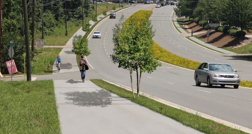
Bicycle and Pedestrian
Currently, sidewalk is present in two short sections
of the corridor. Cyclists must share US 29 with
vehicles, which has minimal paved shoulders present.
A multi-use path is proposed on the west side of US
29 to provide improved mobility and better access to
downtown China Grove (see photo-simulation at right).
A separated facility is proposed instead of on-road
bicycle lanes due to the high speed limit and partial
designation as a truck route. This is a deviation from
current Cabarrus-Rowan MPO’s Comprehensive
Transportation Plan which recommends on-street
bicycle lanes.
Crosswalks and pedestrian signals are proposed at all
signalized intersections. Push-buttons to activate the US 29 Existing Cross-section
pedestrian signals are proposed at each signalized
intersection approach. Mid-block crossings or high-
intensity activated crosswalk (HAWK) beacons are not
proposed due to the corridor’s 55 mile per hour speed
limit and limited pedestrian activity.
US 29 Future Cross-section (photo-simulation)
28 US 29 Corridor Study | China GroveUS 29 at E Church Street/Lentz Road Benefits of enhanced access management include:
Lentz Road is proposed to be re-aligned to intersect • Improving safety by eliminating potential points of
US 29 at Centerview Street, as shown Figure 16. The vehicular conflict
nt)
existing portion Lentz Road would be converted to a • Improving traffic flow by limiting or reducing left-
Lentz Road (Existing Alignme
cul-de-sac prior to the intersection with US 29. turns and areas where drivers must slow down to
A traffic signal would likely be warranted at the accommodate turning or merging vehicles
new four-way intersection of US 29 and Centerview • Providing the business community with clear
Street/Lentz Road. The traffic signal at US 29 and expectations on where their sites will be permitted
E. Church Street would subsequently be reduced to construct driveways.
to three phases, improving travel times through the Improvements at the intersection of US 29 and E t) n
intersection by allowing more green light time to Church Street/Lentz Road are included in the NCDOT me
gn
traffic on US 29. Additionally, the dedicated left turn 2020-2029 State Transportation Improvement e d Ali
lane on US 29 to Lentz Road could be reallocated and Program (STIP) as Project No. U-6130, with right-of- o p os ad
o
restriped to accommodate a dedicated right turn lane (Pr tz R
way acquisition scheduled for fiscal year 2025 and n
for traffic turning west onto Church Street/NC 152. construction for fiscal year 2027.
Le
Commercial driveways near the intersection are Access management implemented to manage
Existing open driveways near the intersection of driveways near the intersection of US 29 and
proposed to be consolidated, reducing the number
US 29 and Church Street/NC 152 Church Street/NC 152 (photo-simulation)
of conflict points on US 29 and providing greater
separation between driveways and the intersection.
This is a noted safety benefit for bicyclists and
pedestrians, as they have fewer crossings where
interaction with vehicular traffic occurs.
Access management is the intentional control of
access points to a corridor, including side streets and
driveways. Improvements in access management are
crucial to enhancing mobility on developing corridors.
US 29 Corridor Study | China Grove 29S T R AT E G Y D E V E L O P M E N T
Reduced-Conflict Intersection RCIs compared to traditional intersections.
Key Benefits of RCIs
To improve safety and traffic flow on US 29, the In the interim condition, a partial superstreet • Improved Safety: Reduces the number of points
long-term goal of the corridor is to be converted conversion is proposed. Left-turns from side streets where vehicles cross paths and eliminates the
to a superstreet, also known as reduced-conflict onto US 29 would be prohibited except at signalized potential for head-on crashes as demonstrated in
intersection (RCI) treatment. RCIs cut more than intersections. Left-turns from US 29 onto side Figures 16 and 17.
half of the potential locations, or conflict points, streets would be permitted, with the exception of
where drivers may collide with other vehicles the southbound left-turn onto John Street. Due to • Increased Efficiency: Each direction of the major
or pedestrians when compared to traditional the skew of the intersection, a greater distance street can operated independently creating two one-
intersections. While drivers on the main road travel must be crossed thus requiring more time to safely way streets and increasing the overall intersection
through an intersection, raised islands redirect the complete the left-turn onto John Street. Drivers capacity.
drivers coming from side streets to turn right. When would instead turn right onto US 29 and complete a • Shorter Wait Times: Fewer traffic signal phases
there is a safe opening in traffic, side street drivers U-turn at the intersection of US 29 and Pine Ridge means less stopping for mainline vehicles and right
turn right to easily enter the flow of traffic on the Road, approximately 800 feet south of John Street. turns only from the side street vehicles means less
main route. To go the other direction or cross the time waiting.
highway, drivers can pull into a dedicated lane to • Cost-effective: An RCI can be more cost-effective
make a U-turn. Traffic signals may be necessary at than adding lanes to improve capacity.
U-turn locations.
M O R E I N F O R M AT I O N
RCIs are able to accommodate higher traffic NCDOT has a video describing the benefits of RCIs and
volumes than traditional intersections, requiring demonstrating how RCIs operate at:
fewer property impacts compared to adding travel https://www.ncdot.gov/initiatives-policies/Transportation/safety-
lanes. Figures 16 and 17 illustrate the safety of mobility/superstreets
Figure 16: Higher Conflict Intersection Example (Source: VDOT) Figure 17: Reduced-Conflict Intersection Example (Source: VDOT)
30 US 29 Corridor Study | China GroveGateway Features
The character of China Grove, its neighborhoods, and
places of interest are largely determined by the look
and feel of its streets. This is particularly true along
gateways and major commuter routes. To help shape
the character of US 29 as redevelopment occurs,
the Town should consider guidelines and standards
that inform changes and help establish a consistent
aesthetic to the corridor. Collectively, these actions
will enhance the user experience – whether in a car,
on a bicycle, or on foot – and better position US 29
to receive development. Inclusion of monumentation
and branded signage can help define the Town and
create a sense of arrival for those traveling outside
of the area. Five key opportunity areas for gateway
enhancements, include: Centerview Street at US 29 Existing
• N. Main Street
• Near I-85/NC 152 Interchange
• Church Street
• Centerview Street
• Coach Deal Road/Bostian Road
Connectivity Opportunities
As many of the large parcels along US 29 gain
development interest, it will be important to improve
cross parcel access and supplement the existing
street network with new connections. Figure 16
provides an example of additional connectivity
between the proposed realignment of Lentz Road and
Grove Street. By improving access and circulation
between parcels, the Town can help reduce the
number of trips reliant on US 29. Centerview Street at US 29 Enhanced Gateway Opportunity (photo-simulation)
US 29 Corridor Study | China Grove 31S T R AT E G Y D E V E L O P M E N T
Probable Cost Opinions for Major US 29 Multi-use Path (west side of US 29 Sidewalk (east side of
Infrastructure Improvements corridor) corridor)
The probable cost opinions for projects along the US N. Main Street to Liberty Street Bostian/Coach Deal Road to South of
29 corridor were generated using NCDOT’s per- Length: 3,165 feet Centerview Street
mile construction costs for planning level data. This Length: 6,650 feet
Design Cost: $ 925,000
methodology is intended to generate high-level, order
ROW Cost: $ 5,000 Design Cost: $ 225,000
of magnitude estimates to be used for planning and
prioritization purposes only. In addition to the per-mile Utilities: $ 55,000 ROW Cost: $ 5,000
construction costs, contingencies were added for Construction: $ 1,950,000 Utilities: $ 115,000
mobilization, engineering, right-of-way, and utilities. Total Cost: $ 2,935,000 Construction: $ 980,000
The cost estimates are summarized in the tables Total Cost: $ 1,325,000
that follow. As projects progress through the project Liberty Street to south of Centerview Street
development process, they corridor may be further Length: 2,820 feet South of Centerview Street to Grove Street
segmented into more reasonable project lengths and Length: 3,550 feet
Design Cost: $ 275,000
costs. Additionally, many of these recommendations Design Cost: $165,000
will happen incrementally over time as development ROW Cost: $ 5,000
Utilities: $ 50,000 ROW Cost: $5,000
occurs.
Construction: $ 1,395,000 Utilities: $60,000
Lentz Road Realignment Construction: $660,000
Total Cost: $ 1,725,000
This cost opinion assumes that Lentz Road is built as Total Cost: $890,000
2-lane undivided section with sidewalks, installation of South of Centerview Street to Bostian/Coach
a traffic signal, and construction of a small culvert for Deal Road
the East Centerview Branch.
Length: 7,180 feet
Lentz Road Realignment Design Cost: $ 505,000
Length: 1,080 feet ROW Cost: $ 10,000
Design Cost: $ 151,500 Utilities: $ 125,000
ROW Cost: $ 505,000 Construction: $ 3,255,000
Utilities: $ 151,500 Total Cost: $ 3,895,000
Construction: $ 1,565,600
Total Cost: $ 2,373,500
32 US 29 Corridor Study | China GroveACTION PLAN
ACTION PLAN
Action Plan
The US 29 Corridor Study was structured to be              Coordination with the Development
visionary without losing sight of the opportunities
and constraints that will drive implementation. The        Community
recommended strategies in the previous pages need a        The US 29 Corridor Study provides a series of
framework to guide investment and decision making.         recommendations intended to enhance the user
It is also intended that this plan be flexible and allow   experience for all modes of travel, as well as the
Town staff, the MPO, and NCDOT to capitalize on new        corridor aesthetics. The recommendations in this
opportunities as they arise. Both public and private       plan should be considered as development or
investment of time and money will be needed to             redevelopment opportunities are identified within the
achieve the desired vision for US 29.                      study area. Recommendations in this plan will serve
                                                           as a starting point for discussions with interested
The matrix on the following page categorizes the
                                                           developers in the area, thereby facilitating continuity
recommended strategies by anticipated cost, level of
                                                           between the use of public and private funds.
impact (1 = low, 5 = high), and lead partner agency. It
is important to remember that the timing and success
of implementation is subject to the availability of time
and money, the degree to which China Grove and
NCDOT can work with the development community,
and the interdependence of implementation.

Coordination with CRMPO and
NCDOT
Following the completion of the US 29 Corridor Study,
it will be the Town’s responsibility to work in close
coordination with the Cabarrus-Rowan MPO to ensure
that the Town’s needs are reflected in the region’s
CTP and MTP, and as appropriate submitted to the
State for prioritization and inclusion in the Statewide
Transportation Improvement Program.

34        US 29 Corridor Study | China Grove
Mobility and
Category Strategy Cost Land Use Participation
Impact
Amend the UDO to better address mixed use, parking, design standards, and
UDO Modifications streetscaping
$ 5 China Grove
China Grove
MPO
Bicycle & Pedestrian Construct a continuous multi-use path $$$ 4
NCDOT
Private
China Grove
MPO
Construct a continuous sidewalk $$ 4
NCDOT
Private
China Grove
Enhance crossing opportunities at signalized intersections $ 5 MPO
NCDOT
MPO
Corridor Modifications Convert intersections to reduced conflict intersections $$$ 3
NCDOT
MPO
Realign Lentz Road to meet US 29 at Centerview Street $$ 4
NCDOT
Initiate the installation of gateway features to improve Town identify and US
Gateway Features 29 appearance
$$ 2 China Grove
China Grove
Connectivity Enhance cross parcel access and increase street connectivity $$ 4
Private
US 29 Corridor Study | China Grove 35You can also read