Sites Mitigation adoption draft - European Supplementary Planning Document - Cornwall Council
←
→
Page content transcription
If your browser does not render page correctly, please read the page content below
European
Sites Mitigation adoption draft
Supplementary Planning Document
February 2021

                                  www.cornwall.gov.uk
Part 1: Terrestrial European
Sites Mitigation

                               www.cornwall.gov.uk
Contents
Summary 3
Introduction 4
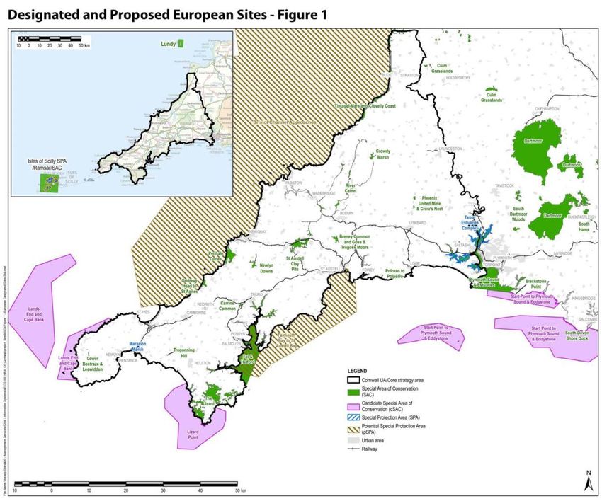
Legal Background 5
Cornwall’s Sites 5
The Local Plan and the Mitigation of Recreational Impacts 5
Usage Surveys and Zone of Influence 6
Zones of Influence 6
Submitting a Standard Appropriate Assessment 7
Mitigating for Impacts 7
Delivering the Strategic Mitigation Plan 8
Format of an Appropriate Assessment. 8
Appendix 1: Summary of usage surveys 9
Methodology 9
Results 9
Marazion Marsh: Survey results 9
Appendix 2: Designated and Proposed European Sites 11
List of designated and proposed European sites 11
Appendix 3: 12
Penhale Dunes SAC - Strategic Access Mitigation and Monitoring Plan 12
Appendix 4: Standard Appropriate Assessment for submission with
residential applications within the 12.5km zone of influence of
Penhale Dunes SAC. 13
Form 1: Development within 12.km of Penhale Dunes SAC 14
Form 4: Development within 12.5km of both the Fal and Helford SAC &
12.5km of Penhale Dune SAC 18
Terrestrial European Sites Mitigation proposed | Supplementary Planning Document Page 2Summary
1. European legislation requires appropriate mitigation before planning applications, that would otherwise cause harm to European wildlife sites, including in
combination with others, can be approved. The requirement for this is reinforced further in the Local Plan: Strategic Policies Policy 22: European Protected
Sites - mitigation of recreational impacts from development.
2. The evidence for this can be complex and a significant burden on smaller scale developments. It can also be difficult to achieve realistic mitigation
strategies in isolation.
3. In agreement with Natural England, Cornwall Council has carried out recreational use surveys and devised a strategic mitigation program for the
Penhale Dunes Special Area of Conservation (SAC). Applicants are encouraged to use this as a standard method, evidence base and mitigation. This is
applicable where the only impact on European wildlife sites is through increased recreational use.
4. Based on this advice a one off payment to a strategic mitigation plan can be submitted with each application within 12.5km of Penhale Sands. This has
been agreed, between the Council (as ‘Competent Authority’) and Natural England, to meet the Habitats Regulations’ obligations and to alleviate the
burden on developers of providing bespoke evidence and mitigation.
5. Otherwise full and bespoke assessment and mitigation will be required within 12.5km.
6. Similar advice for development affecting the Fal and Helford SAC; Plymouth Sound & Estuaries SAC and the Tamar Estuaries Complex SPA will be agreed
following a separate consultation and added to this SPD in due course.
Terrestrial European Sites Mitigation proposed | Supplementary Planning Document Page 3Introduction
7. This Supplementary Planning Document (SPD) provides a ready solution for Appropriate Assessment and mitigation for people who are submitting planning
applications that;
• fall within the zones of influence of European protected sites in Cornwall, and
• where recreational disturbance is the only Habitat Regulations issue.
8. It sets out a strategic approach to the provision of mitigation for an increase in potentially harmful recreational impacts arising from new housing and tourism
growth. The intention of this strategically led mitigation is to provide the best joined up solution for the European sites management to ensure their future
conservation status.
9. This approach addresses the requirements of the Habitats Regulations Assessment and in doing so provides individual developers with a standard solution to
Appropriate Assessment and mitigation.
10. This SPD explains where Appropriate Assessment and mitigation of recreational impacts is required and why and sets out the solutions to achieving this.
Terrestrial European Sites Mitigation proposed | Supplementary Planning Document Page 4Legal Background
11. The Conservation of Habitats and Species Regulations 2010 sets out how Local Planning Authorities (LPAs) must require appropriate mitigation from
development that has a likely significant effect on European wildlife sites (Special Protection Areas, Special Areas of Conservation and Ramsar sites). This
impact may be direct such as the physical loss or damage to the European site, or more indirect impacts:
• distant development may cause significant impact on the key species when they are away from the designated site
• a single development may have a small effect but a combined (cumulative) overall large effect
12. Section 61 of the Habitat Regulations requires the Local Planning Authority (LPA) to firstly assess whether a significant effect from the proposal is likely. If the
LPA considers it is likely then the LPA must undertake an Appropriate Assessment (AA) to consider whether or not the effect can be fully mitigated and consult
Natural England on the statutory submission of an AA .
13. The Conservation of Habitats and Species Regulations 2010 set out that LPAs must not grant consent for a development that would, either alone or in-
combination with other developments, have a likely significant effect on a European wildlife site, unless full mitigation is provided.
14. The only exception is where the development is of over-riding public interest. Such proposals must be referred to the Secretary of State and any unmitigated
effects must be fully compensated.
Cornwall’s Sites
15. European Sites h ave been designated following the EC Habitats Directive (1992), interpreted into British law by the Conservation of Habitats and Species
Regulations (2010). The aim of the Directive is to “maintain or restore, at favourable conservation status, natural habitats and species of wild fauna and flora of
Community interest” (Habitats Directive, Article 2(2)).
16. There are 25 designated European sites (SACs, SPAs and candidate and potential European sites (cSACs and pSPAs)) that lie wholly or partly within Cornwall.
These are set out in Appendix 2. For the purposes of this SPD cSACs and pSPAs are treated in the same way as SAC and SPA sites.
The Local Plan and the Mitigation of Recreational Impacts
17. The Local Plan sets out land use planning policies and identifies the quantity and broad location and key sites, for new housing, community facilities, shops and
employment. Policy 22 of the Cornwall Local Plan sets out requirements for mitigation of recreational impacts from new development on European sites.
18. This SPD sets out a methodology, evidence and acceptable mitigation solutions for development subject to Habitat Regulations rules.
Terrestrial European Sites Mitigation proposed | Supplementary Planning Document Page 5Usage Surveys and Zone of Influence
19. The Local Plan process and HRA recreationalFigure 2
studies (done by the Council to national standards
and agreed with Natural England) identified
the following sites as vulnerable to threat and
require mitigation due to potential for increased
recreational pressure:
Terrestrial Sites:
• Penhale Dunes SAC
And Marine and Estuarine Sites1
• Fal and Helford SAC
• Plymouth Sound and Estuaries SAC 12.5km buffer
Tamar Estuaries Complex SPA
20. The process for screening out other European Penhale
Tamar
Estuaries
Dunes complex
sites is documented and can be seen at http://
www.cornwall.gov.uk/europeansitespd. Godrevy Head to St Agnes
Carrine Common
Zones of Influence Plymouth Sound
and Estuaries
21. The recreational studies derived, for AA and
mitigation purposes, the zone of influence (ZoI) for
12.3km buffer
Penhale Dunes that reflects the area from which the
majority of visitors, and most potential harm, travel Falmouth Bay to
St Austell Bay
from to access the site for recreational purposes.
´
22. For Penhale Dunes SAC this zone is the area within Marazion
Marsh
Fal and Helford 0 5 10 Kilometres
12.5 km of the site. © Crown copyright and database rights 2020 Ordnance Survey 100049047.
12.5km buffer
23. A summary of the survey methodology is
presented in Appendix 1: The full Survey and
Methodology can be viewed on the Council’s
web pages http://www.cornwall.gov.uk/
europeansitespd
Terrestrial European Sites Mitigation proposed | Supplementary Planning Document Page 6Submitting a Standard Appropriate Assessment
24. Development within the area identified on the map above requires an AA for their potential individual or in combination impact to European sites. A standard
AA, for use where recreational disturbance is the only concern for the SAC, is appended to this SPD (Appendix 4).
25. This SPD applies to all new housing, student accommodation and tourist accommodation where there is a net gain in units:
• Hotels, guest houses, B&Bs, lodges, static caravans & touring pitches
• Flats as well as larger dwellings
• Affordable housing as well as market housing
• Student accommodation – per bedroom space.
• Tied accommodation
• Residential caravans/mobile homes/park homes – proportional to restricted periods of occupancy (e.g. 5 months per year = 42% of the full contributions).
26. Where student / tourist accommodation is provided on a room basis the normal unit contribution is divided by 2.4 to give a per-bedroom rate. The figure of 2.4
is derived as the average householder occupancy rate.
Mitigating for Impacts
27. Mitigation for recreational impacts can take the form of managing access and visitor behaviour near and within the European sites, making sites more resilient
to recreational pressure, or making provision of appropriate alternative recreation locations to draw users away from using the European sites.
28. The evidence supports Cornwall Council’s proposed solution of an approach commonly known as Strategic Access Management and Monitoring or SAMM. This
includes management within the internationally designated site, as well as monitoring of its condition and impacts. From this the Council has devised a Strategic
Mitigation Plan for Penhale Dunes SAC.
29. To achieve these mitigation measures, all residential development within the zones shown above, are expected to contribute. Alternatively, proposals must provide
their own assessments that will provide the necessary mitigation measures for recreational pressures on the European Site.
30. The anticipated level of contributions is based on a proportional contribution to the agreed Strategic Mitigation Plan for Penhale Sands SAC.
31. The contribution is based upon the cost of the Strategic Mitigation Strategy for a period of 80 years (agreed with Natural England as a reasonable in perpetuity
time period) divided by the number of houses within the Zone of Influence (ZoI), as set out above.
32. The costs per dwelling and per bedroom for student, tourist and active elderly provision are set out in the following table:
Cost per unit Cost per bedroom for student/serviced
Site name: Measures required
(per bedroom where applicable) accommodation
Penhale Dunes SAC Strategic Mitigation Plan £180 £75
Terrestrial European Sites Mitigation proposed | Supplementary Planning Document Page 733. Agreement to the payment solution must be secured prior to approval of the development and delivered through a section 106 agreement or Unilateral
Undertaking or through a planning condition as appropriate.
34. Appropriate draft wording for a condition of the permission is included in the standard AA (Appendix 4)
35. Providing Suitable Alternative Natural Greenspace (SANG) can be an alternative solution and comprises the creation of natural informal public open space to
divert people from the internationally designated site.
36. Since the initial SAMMs list was drawn up and agreed, the development at the Newquay Growth Area has proposed a 44 hectares Suitable Alternative Natural
Greenspace as mitigation of the recreational impact of the new development on Penhale Dunes SAC. This SANG is currently being delivered. The SAMMs list has
been adjusted to reflect the reduction of new dwellings which place recreational pressure on the SAC.
Delivering the Strategic Mitigation Plan
37. The Strategic Mitigation Plan for Penhale Sands SAC includes the provision of mechanisms such as site management and/ or a program of condition monitoring
and assessment. Education and public engagement are key to delivering behavioural change to minimise any recreational impacts.
38. The Strategic actions are set out in Appendix 3: the Penhale Dunes SAC - Strategic Mitigation Plan.
Format of an Appropriate Assessment.
39. All development where significant effect is identified must provide AA.
40. Where recreational disturbance is the only mechanism of impact (where the impact is always in combination with other residential developments) the Council
will accept a standard Appropriate Assessment based on the Council’s recreation survey and the mitigation set out in the Strategic Mitigation Plan for Penhale
Dunes SAC.
41. The format and recommended content of the standard AA is attached as Appendix 4 of this SPD and should be completed for all applications within the ZoI for
the recreational pressure on the SAC.
42. Mitigation will be by Section 106 agreement on larger scale proposals and a condition on planning consents based on the proposed text in the attached
standard format AA.
43. Alternatively applications must meet the regulations with Appropriate Assessment and mitigation agreed with Natural England.
Terrestrial European Sites Mitigation proposed | Supplementary Planning Document Page 8Appendix 1: Summary of usage surveys Methodology For the three terrestrial sites, Penhale Dunes SAC, Godrevy to St Agnes Head SAC and Marazion Marsh SPA, surveys commenced in Autumn 2015 and were completed in Summer 2016. There were two main aims of the surveys. The first was to gather postcodes of people visiting the sites in order to identify zones of influence from which people travel to use the European Designated Site. The second was to examine the behaviour of visitors and draw conclusions as to the likely impact and mitigation required. Results Penhale Survey Results: Over the four seasons, 406 groups were interviewed, representing 706 people and 696 dogs. Overall 87% of visitors lived in Cornwall and 13% were visitors. 95% of local visitors and 79% of non-resident visitors were dog walking. As expected a higher number of visitors who lived outside Cornwall were interviewed in Summer compared to those interviewed over the Winter survey sessions (28% compared to 1%.) 95% of local visitors arrived by car. For tourists the split was closer to 50:50 because 55% arrived on foot from Penhale Sands, the campsite adjoining the SAC. Across the seasons Penhale was specifically visited by some local residents in preference to other destinations, as they considered it to be large, level, dry and dog friendly, with easy parking and the ability to let the dog off the lead safely. 64% of visitors stated that they visit all year round. Local resident groups who were dog walking were the most frequent visitors to the site. 32% of local resident visitors resided in the Civil Parish of Perranzabuloe, 12% in Truro, 8% in Newquay and 6% in Kenwyn. 14 postcodes of holiday accommodation from non-local resident visitor groups were captured and were all located in the Civil Parish of Perranzabuloe. In light of a 23% increase in housing within 12,500m of Penhale, a 21% predicted increase in recreational visits is expected. This could increase recreational pressure on the site to the extent that there may be significant effects, if not mitigated. The data gathered from the visitor field work has been analysed to identify zone of influence around Penhale of 12.5km. Marazion Marsh: Survey results Over the four seasons 175 groups were interviewed, representing the visit patterns of 280 people accompanied by 109 dogs. 33% of groups were interviewed during the Autumn, 32% in Spring, 20% in the Summer and 15% over the Winter. On average 52% of groups were accompanied by dogs. 74% of all interviewed. Evidence suggests that a strategic solution to mitigation for Marazion Marsh is not required. Locational data suggested this is not a strategic site for recreation. Regular walkers come from a small local range and use the site regularly, but cause little disturbance at present to the protected species. Birdwatchers also use the site regularly and tend to travel further to the site, but their activities are not harmful to the protected species. This is not a ‘destination’ for dogwalking since the area available is very small – it is just part of regular local routes. There is current wardening and signs clearly identifying the special features of the site. Although the warden identifies dog fouling and disturbance as an issue, there are measures in place to reduce disturbance (fences) and there are dog bins at the site entrance/exits. It is hard to see how this could be improved by financial contributions. The warden reports an increase in dog walking during the summer months, when the beach ban operates, but at this time of year the protected features are not present. Terrestrial European Sites Mitigation proposed | Supplementary Planning Document Page 9
Kite surfing is more dependent on weather conditions and on interest in the sport than on where people live. Since there are a limited number of beaches in Cornwall
where the sport can take place in each wind direction, participants will travel from a wide area. The increase in numbers in the summer months is related to tourism –
again this is a time when the protected features are not present.

Terrestrial European Sites Mitigation proposed | Supplementary Planning Document                                                                               Page 10
Appendix 2: Designated and Proposed European Sites
                                                                                   List of designated and proposed European sites
                                                                                   Breney Common and Goss & Tregoss Moors SAC
                                                                                   Carrine Common SAC
                                                                                   Crowdy Marsh SAC
                                                                                   Fal & Helford SAC
                                                                                   Falmouth Bay to St Austell Bay pSPA
                                                                                   Godrevy Head to St Agnes SAC
                                                                                   Land’s End and Cape Bank cSAC
                                                                                   Lizard Point cSAC
                                                                                   Lower Bostraze and Leswidden SAC
                                                                                   Lundy Island SAC
                                                                                   Newlyn Downs SAC
                                                                                   Penhale Dunes SAC
                                                                                   Phoenix United Mines & Crows Nest SAC
                                                                                   Plymouth Sound & Estuaries SAC
                                                                                   Polruan to Polperro SAC
                                                                                   River Camel SAC
                                                                                   St Austell Clay Pits SAC
Figure 1 – Designated and proposed European sites                                  The Lizard SAC
                                                                                   Tintagel-Marsland-Clovelly Coast SAC
                                                                                   Tregonning Hill SAC
                                                                                   Marazion Marsh SPA
                                                                                   Tamar Estuaries Complex SPA

Terrestrial European Sites Mitigation proposed | Supplementary Planning Document                                                Page 11
Appendix 3:
Penhale Dunes SAC - Strategic Access Mitigation and Monitoring Plan
The Plan below has been compiled based on the evidence from the recreational studies at Penhale and in conjunction with Cornwall Wildlife Trust, who manage the
Penhale Dunes SAC and Cornwall Council as the Competent Authority for HRA purposes. The list represents the resources required in order to provide an effective
program of mitigation, making the SAC more resilient to visitor pressure.
The primary objective is to raise awareness of causes of harm and influence better behaviour on site by users.
Some items are one off expenditures, some measures have a set life span, and some costs are annual. The cost is calculated over 80 years with the aim of ensuring
that funds can provide mitigation in perpetuity
Items are ranked in terms of their priority, as agreed with Cornwall Wildlife Trust.
Cornwall Council will be the client and management by appropriate task.
Rank Item Unit cost No. of years required for In perpetuity cost
1 Dog warden visits once a week to enforce dog fouling and 5 hrs per month at £xk 80 £336,000
undertake proactive work with dog walkers educating them about
the site and why it is important to pick up after their dog.
2 Dog fouling campaign to raise awareness of SAC using CC Comms £1,000 16 (every 5 years campaign £16,000
team to delivery press releases, social media and radio TV repeated
Interviews.
3 Replacing wooden demarcation bollards which prevent parking £2,000 5 (5 further replacements likely £10,000
within the SAC. within 80 year period)
4 Improvements to parking area to prevent parking on verges £3,000 5 (5 further replacements likely £15,000
(wooden teeth etc) within 80 year period)
Total for 80 years £377,000
Housing numbers rounded £2200
2,100
Per unit contribution £180
Financial contribution as HRA mitigation will contribute to this strategy.
Terrestrial European Sites Mitigation proposed | Supplementary Planning Document Page 12Appendix 4: Standard Appropriate Assessment for submission with residential applications within
the 12.5km zone of influence of Penhale Dunes SAC.
The format and recommended content of the standard Appropriate Assessments are below and should be completed for all applications within the ZoI for the
recreational pressure on the SAC/SPA. Where the Fal & Helford SAC and Penhale Dunes SAC ZOIs overlap, a form to cover both is provided for this.
• Form 1: Development within 12.3km of Penhale Dunes SAC
• Form 2: Development within 12.5km of Fal and Helford SAC (see marine and estuarine European Sites SPD document)
• Form 3: Development within 12.5k of Tamar Estuaries SAC and Plymouth Sound and Estuaries SPA (see marine and estuarine European Sites SPD document)
• Form 4: Development within 12.5km of both the Fal and Helford SAC & 12.5km of Penhale Dune SAC
Electronic versions of the forms are available at www.cornwall.gov.uk/europeansitespd
Terrestrial European Sites Mitigation proposed | Supplementary Planning Document Page 13Form 1: Development within 12.km of Penhale Dunes SAC
Valid date: January 2020 - January 2021 annual review.
Habitat Regulation Assessment (HRA)
Screening Matrix and Appropriate Assessment Statement
PLEASE NOTE: Undertaking the HRA process is the responsibility of the decision maker as the Competent Authority for the purpose of the Habitats Regulations,
however, it is the responsibility of the applicant to provide the Competent Authority with the information that they require for this purpose. This template is to
be used only for applications within the zone of impact identified for Penhale Dunes SAC.
Cornwall Council Use:
Application reference:
Application address:
Application description:
Status of Application:
Proximity to SPA/SAC: Within the 12.5km Zone of influence for Penhale Dunes SAC
Grid Ref:
Lead Planning Officer:
Stage 1 - details of the plan or project
European site potentially impacted by planning application, plan or project. Recreational disturbance only; OR
Recreational disturbance and/or other impacts.
Is the planning application, project or plan directly connected with or necessary to YES
the management of the site? [if yes, Applicant should have provided evidence and
NO
justification]
Other than for applications where recreational disturbance is the only mechanism YES (specify the mechanism(s) of impact);
of impact (where the impact is always in combination with other residential
NO; or
developments), are there any other projects or plans that together with the planning
application being assessed could affect the site? [Applicant to provide the information N/A (recreational disturbance only)
sufficient to allow an ‘in combination’ effect to be assessed]
Terrestrial European Sites Mitigation proposed | Supplementary Planning Document Page 14Stage 2 – HRA screening assessment
Test 1: the significance test – The Applicant is to provide evidence so that a judgement can be made as to whether there could be any potential significant impacts of the
development on the integrity of the SPA/SAC/Ramsar.
We cannot take into account any avoidance and mitigation measures as part of the application at this stage of HRA. For applications where recreational disturbance is the only
mechanism of impact, on the basis of the findings of the recreational survey we accept Natural England’s advice that such applications without mitigation will have a likely
significant effect on the SPA(s) in combination with other residential development in the zones of influence. Therefore all applications, even where a payment to a scheme of
mitigation is proposed, will progress directly to Stage 3.
For other applications does the evidence submitted show a likely significant effect, without mitigation measures (either alone or in-combination with other plans or projects)
YES NO
[If yes, ask for further guidance from Cornwall Council on a bespoke AA. The standard AA below cannot be used]
Stage 3 - HRA – Appropriate Assessment
Test 2: the integrity test – If there are any potential significant impacts, the applicant must provide evidence showing avoidance and/or mitigation measures to allow an
Assessment to be made. The Applicant must also provide details which demonstrate any long term management, maintenance and funding of any solution.
Penhale Dunes SAC (UK0012559) Site Improvement Plan sets out the Quality & Importance and qualifying features as:
Shifting dunes along the shoreline with Ammophila arenaria (‘white dunes’) for which the area is considered to support a significant presence. Dunes with Salix repens ssp.
argentea (Salicion arenariae) for which the area is considered to support a significant presence which is considered to be rare as its total extent in the United Kingdom is
estimated to be less than 1,000 hectares. Humid dune slacks for which this is considered to be one of the best areas in the United Kingdom. Fixed dunes with herbaceous
vegetation (‘grey dunes’) for which this is considered to be one of the best areas in the United Kingdom. Rumex rupestris (Shore dock) for which this is considered to be one of
the best areas in the United Kingdom. Gentianella anglica (Early gentian) for which this is considered to be one of the best areas in the United Kingdom. Petalophyllum ralfsii
(Petalwort) for which this is considered to be one of the best areas in the United Kingdom.
Matrix: Impact of residential development: Penhale Dunes SAC
Potential Effect Site Conservation Objective(s) Potential for Impact? Relevant Mitigation Measures
Public Access/ Disturbance Increase public awareness and information Yes. Penhale Dunes SAC Strategic
regarding the impacts of dog fouling and Mitigation Plan
Increase use/ fouling & trampling.
trampling.
Inappropriate coastal management Increase bare sand, dune slack and short turf No n/a
habitats
Invasive species Complete and implement a scrub and invasive No n/a
species management plan
Change in land management Review africultural management and consents No n/a
Hydrological changes Improve understanding of links between features No n/a
and hydrology.
Air pollution risk of atmospheric nitrogen Further investigation. No n/a
deposition
Terrestrial European Sites Mitigation proposed | Supplementary Planning Document Page 15The likely effectiveness and long-term financial robustness of the management of Penhale Dunes SAC have been examined by Cornwall Council in agreement with Natural England. This is set out and costed in the Penhale Dunes SAC Strategic Mitigation Plan and detailed in the ‘European Sites Mitigation – Supplementary Planning Document’. These will be implemented by the Council. If this is accepted by the applicant, the applicant does not need to provide new evidence base on these aspects. Instead evidence should be submitted that a mitigation contribution payment of £180 per dwelling, or per bedroom in proposed properties of multiple occupation where appropriate, has either; • been made with the planning application [refundable if application refused] OR • been made to the appropriate scheme through a Unilateral Undertaking or planning condition; OR • will be made through a condition or S106 agreement where Heads of Terms have been agreed and the agreement will be signed prior to any permission being granted. The following text should be used only for those applications where mitigation of recreational disturbance is the sole issue and that mitigation is proposed through one or other of the existing local authority managed schemes and by condition. Where the applicant accepts the mitigation measures set out in the Strategic Mitigation Plan they must either pay, in advance of approval OR agree to enter a legal agreement by Section 106 agreement on larger scale proposals OR a condition on planning consents based on the following as appropriate: The applicant has made an appropriate contribution prior to approval of planning permission and met HRA obligations. OR Condition: The development hereby permitted shall not be commenced until the Local Planning Authority has approved, in writing, a scheme to secure mitigation of the additional recreational pressures to the Penhale Dunes Special Area of Conservation, together with an appropriate mechanism to secure delivery of the mitigation. Informative: The Penhale Dunes SAC - Strategic Mitigation Plan, to be delivered by the Council, is considered by Cornwall Council, in agreement with Natural England, to be an approved scheme and appropriate mechanism. Where the applicant agrees to accept this Mitigation Plan the condition can be satisfactorily addressed by means of a financial contribution towards the Mitigation Plan. In this instance, such a contribution would amount to . OR Condition: The development hereby permitted shall not be commenced until the Local Planning Authority has approved, in writing, a scheme to secure mitigation of the additional recreational pressures to the Penhale Dunes Special Area of Conservation, together with an appropriate mechanism to secure delivery of the mitigation. Informative: The Penhale Dunes SAC - Strategic Mitigation Plan, to be delivered by the Council, is considered by Cornwall Council, in agreement with Natural England, to be an approved scheme and appropriate mechanism. Where the applicant agrees to accept this Mitigation Plan the condition can be satisfactorily addressed by means of a financial contribution towards the Mitigation Plan. In this instance, such a contribution would amount to . Reason: The development lies in a zone of influence of the Penhale Dunes Special Area of Conservation where it is considered there would be a likely significant effect, when taken in combination with other plans and projects, upon this European designated site. To ensure that the proposal may proceed as sustainable development, there is a duty upon the Local Planning Authority to provide sufficient mitigation for any recreational impacts which might arise upon the European designated site. In coming to this decision, the Council has had regard to Regulation 61 of the Conservation of Habitats and Species Regulations 2010 and the requirements of Policy 22 of the Cornwall Local Plan Strategic Policies 2010 - 2030. N.B. Where bespoke schemes of mitigation for recreational disturbance are proposed, or for other mechanisms of impact, much more detailed evidence will have to be submitted in order to allow the Appropriate Assessment to be made. Terrestrial European Sites Mitigation proposed | Supplementary Planning Document Page 16
Stage 4 – Summary of the Appropriate Assessment (To be carried out by the Competent Authority (the local planning authority) in liaison with Natural England
 Cornwall Council
 Conclusion
 Having considered the proposed mitigation and avoidance measures to be provided in-perpetuity through the secured contribution to the Penhale Dunes SAC Strategic
 Mitigation Plan, Cornwall Council conclude that the effects have been assessed and so long as a contribution to the Mitigation Plan is made the integrity of the European Site
 will be maintained.
 Having made this Appropriate Assessment of the implications of the application on the site’s conservation objectives, and having consulted Natural England and considered any
 representation received (see below), the authority can now approve the planning application under regulation 63 of the Conservation of Habitats and Species Regulations 2017.
 Natural England
 Summary of Natural England’s comments:
 Providing that the Appropriate Assessment concludes that these measures are secured though planning conditions, planning obligations or other legally binding measures to
 ensure their strict implementation for the full duration of the development, and providing that there are no other adverse impacts identified by your Authority’s Appropriate
 Assessment, Natural England is satisfied that your Appropriate Assessments can ascertain that there will be no adverse effect on the integrity of the European Site in view of its
 conservation objectives.

Terrestrial European Sites Mitigation proposed | Supplementary Planning Document                                                                                             Page 17
Form 4: Development within 12.5km of both the Fal and Helford SAC & 12.5km of Penhale Dune SAC
Valid date: June 2019 - June 2020 annual review.

Habitat Regulation Assessment (HRA)
Screening Matrix and Appropriate Assessment Statement
PLEASE NOTE:  Undertaking the HRA process is the responsibility of the decision maker as the Competent Authority for the purpose of the Habitats Regulations,
however, it is the responsibility of the applicant to provide the Competent Authority with the information that they require for this purpose.  This template is to
be used only for applications within both the zones of impact identified for Penhale Dunes SAC and the Fal & Helford SPA.

 Cornwall Council Use:
 Application reference:
 Application address:
 Application description:
 Status of Application:
 Proximity to SPA/SAC:                                                                     Within the 12.5km Zone of influence for Penhale Dunes SAC and also within the
                                                                                           12.5km Zone of influence for Fal & Helford SAC
 Grid Ref:
 Lead Planning Officer:
 Stage 1 - details of the plan or project
 European site potentially impacted by planning application, plan or project.              Recreational disturbance only; OR
                                                                                           Recreational disturbance and/or other impacts.
 Is the planning application, project or plan directly connected with or necessary to          YES
 the management of the site? [if yes, Applicant should have provided evidence and
                                                                                               NO
 justification]
 Other than for applications where recreational disturbance is the only mechanism              YES (specify the mechanism(s) of impact);
 of impact (where the impact is always in combination with other residential
                                                                                               NO; or
 developments), are there any other projects or plans that together with the planning
 application being assessed could affect the site? [Applicant to provide the information       N/A (recreational disturbance only)
 sufficient to allow an ‘in combination’ effect to be assessed]

Terrestrial European Sites Mitigation proposed | Supplementary Planning Document                                                                                           Page 18
Stage 2 – HRA screening assessment
Test 1: the significance test – The Applicant is to provide evidence so that a judgement can be made as to whether there could be any potential significant impacts of the
development on the integrity of the SPA/SAC/Ramsar.
We cannot take into account any avoidance and mitigation measures as part of the application at this stage of HRA. For applications where recreational disturbance is the only
mechanism of impact, on the basis of the findings of the recreational survey we accept Natural England’s advice that such applications without mitigation will have a likely significant
effect on the SPA(s) in combination with other residential development in the zones of influence. Therefore all applications, even where a payment to a scheme of mitigation is
proposed, will progress directly to Stage 3.
For other applications does the evidence submitted show a likely significant effect, without mitigation measures (either alone or in-combination with other plans or projects)
YES NO
[If yes, ask for further guidance from Cornwall Council on a bespoke AA. The standard AA below cannot be used]
Stage 3 - HRA – Appropriate Assessment
Test 2: the integrity test – If there are any potential significant impacts, the applicant must provide evidence showing avoidance and/or mitigation measures to allow an
Assessment to be made. The Applicant must also provide details which demonstrate any long term management, maintenance and funding of any solution.
Penhale Dunes SAC (UK0012559) Site Improvement Plan sets out the Quality & Importance and qualifying features as:
Shifting dunes along the shoreline with Ammophila arenaria (‘white dunes’) for which the area is considered to support a significant presence. Dunes with Salix repens ssp.
argentea (Salicion arenariae) for which the area is considered to support a significant presence which is considered to be rare as its total extent in the United Kingdom is
estimated to be less than 1,000 hectares. Humid dune slacks for which this is considered to be one of the best areas in the United Kingdom. Fixed dunes with herbaceous
vegetation (‘grey dunes’) for which this is considered to be one of the best areas in the United Kingdom. Rumex rupestris(Shore dock) for which this is considered to be one of
the best areas in the United Kingdom. Gentianella anglica (Early gentian) for which this is considered to be one of the best areas in the United Kingdom. Petalophyllum ralfsii
(Petalwort) for which this is considered to be one of the best areas in the United Kingdom.
Matrix: Impact of residential development: Penhale Dunes SAC
Potential Effect Site Conservation Objective(s) Potential for Impact? Relevant Mitigation Measures
Public Access/ Disturbance Increase public awareness and information Yes. Penhale Dunes SAC Strategic
regarding the impacts of dog fouling and Mitigation Plan
Increase use/ fouling & trampling.
trampling.
Inappropriate coastal management Increase bare sand, dune slack and short turf No n/a
habitats
Invasive species Complete and implement a scrub and invasive No n/a
species management plan
Change in land management Review africultural management and consents No n/a
Hydrological changes Improve understanding of links between features No n/a
and hydrology.
Air pollution risk of atmospheric nitrogen Further investigation. No n/a
deposition
Terrestrial European Sites Mitigation proposed | Supplementary Planning Document Page 19Fal & Helford SAC (UK0013112) Site Improvement Plan sets out the Quality & Importance and qualifying features as:
The Fal & Helford site encompasses the two rias (drowned river valleys) of the Fal Estuary and the Helford River and the inner part of Falmouth Bay between Zone Point on the
Roseland Peninsula and Manacle Point on the Lizard Peninsula. It has been selected as a SAC for the following interest features:
• saltmarsh e.g. top of Fal & Ruan Creeks at Ruan Lanihorne.
• intertidal mudflats e.g. upper reaches of Polwheveral and Frenchman‟s Creeks.
• subtidal sandbanks e.g. maerl beds in the Fal Estuary, particularly the live bed on St. Mawes Bank.
• large shallow inlets and bays e.g. the whole bay from Manacle Point to Zone Point, within this area are habitats such as reefs and rocky shores.
• estuaries e.g. the Fal Estuary and the Helford Estuary.
• reefs e.g. St Anthony‟s Head and inshore around Manacle Point.
Matrix: Impact of residential development: Fal & Helford SAC
Potential Effect Site Conservation Objective(s) Potential for Impact? Relevant Mitigation Measures
Public Access/ Disturbance Review recreational boating study & promote Yes Fal & Helford SAC Mitigation Plan
best practice. Pressure.
Subtidal sandbanks
Review moorings. Threat.
Subtidal sandbanks, Shallow inlet bays, Estuaries
Fisheries: recreational marine & estuarine Indicate where management necessary – Threat. Yes Fal & Helford SAC Mitigation Plan
Estuaries, Intertidal mudflats & sandflats.
Water Pollution Raise awareness of issue Yes Fal & Helford SAC Mitigation Plan
Marine Consents: 1. Shipping Assess impact of anchoring No n/a
2. Channel maintenance Strategy for undesirable terrestrial sediment
Water Pollution Strategy to reduce diffuse nutrient pollution No n/a
Siltation Develop strategy for undesirable terrestrial No n/a
sources of sediment
Fisheries: 1.private Advice to Duchy Oyster Farm No n/a
2.Commercial Regulating order & indicate where management
necessary & co-working to deliver improvement
Air Pollution: nitrogen deposition. Investigate impact of Nitrogen deposition. No n/a
Invasive species Identify scale of non-native issues & manage as No n/a
required.
Management Plan for Pacific Oyster
Terrestrial European Sites Mitigation proposed | Supplementary Planning Document Page 20The likely effectiveness and long-term financial robustness of the management of Penhale Dunes SAC and Fal & Helford SAC have been examined by Cornwall Council in agreement with Natural England. This is set out and costed in the Panhale Dunes SAC Strategic Mitigation Plan and Fal & Helford SAC Strategic Mitigation Plan respectively and detailed in the ‘European Sites Mitigation – Supplementary Planning Document’. These will be implemented by the Council. If this is accepted by the applicant, the applicant does not need to provide new evidence base on these aspects. Instead evidence should be submitted that a mitigation contribution payment of £XXX per dwelling, or per bedroom in proposed properties of multiple occupation where appropriate, has either; • been made with the planning application [refundable if application refused] OR • been made to the appropriate scheme through a Unilateral Undertaking or planning condition; OR • will be made through a condition or S106 agreement where Heads of Terms have been agreed and the agreement will be signed prior to any permission being granted. The following text should be used only for those applications where mitigation of recreational disturbance is the sole issue and that mitigation is proposed through one or other of the existing local authority managed schemes and by condition. Where the applicant accepts the mitigation measures set out in the Strategic Mitigation Plan they must either pay, in advance of approval OR agree to enter a legal agreement by Section 106 agreement on larger scale proposals OR a condition on planning consents based on the following as appropriate: The applicant has made an appropriate contribution prior to approval of planning permission and met HRA obligations. OR Condition: The development hereby permitted shall not be commenced until the Local Planning Authority has approved, in writing, a scheme to secure mitigation of the additional recreational pressures to the Panhale Dunes SAC and Fal & Helford SAC, together with an appropriate mechanism to secure delivery of the mitigation. Informative: The Panhale Dunes SAC Strategic Mitigation Plan and Fal & Helford SAC Strategic Mitigation Plan, to be delivered by the Council, is considered by Cornwall Council, in agreement with Natural England, to be an approved scheme and appropriate mechanism. Where the applicant agrees to accept this Mitigation Plan the condition can be satisfactorily addressed by means of a financial contribution towards the Mitigation Plan. In this instance, such a contribution would amount to . Reason: The development lies in a zone of influence of the Panhale Dunes SAC and Fal & Helford SAC where it is considered there would be a likely significant effect, when taken in combination with other plans and projects, upon this European designated site. To ensure that the proposal may proceed as sustainable development, there is a duty upon the Local Planning Authority to provide sufficient mitigation for any recreational impacts which might arise upon the European designated site. In coming to this decision, the Council has had regard to Regulation 61 of the Conservation of Habitats and Species Regulations 2010 and the requirements of Policy 22 of the Cornwall Local Plan Strategic Policies 2010 - 2030. N.B. Where bespoke schemes of mitigation for recreational disturbance are proposed, or for other mechanisms of impact, much more detailed evidence will have to be submitted in order to allow the Appropriate Assessment to be made. Terrestrial European Sites Mitigation proposed | Supplementary Planning Document Page 21
Stage 4 – Summary of the Appropriate Assessment (To be carried out by the Competent Authority (the local planning authority) in liaison with Natural England
 Cornwall Council
 Conclusion
 Having considered the proposed mitigation and avoidance measures to be provided in-perpetuity through the secured contribution to the Panhale Dunes SAC Strategic
 Mitigation Plan and Fal & Helford SAC Strategic Mitigation Plan, Cornwall Council conclude that the effects have been assessed and so long as a contribution to the Mitigation
 Plan is made the integrity of the European Site will be maintained.
 Having made this Appropriate Assessment of the implications of the application on the site’s conservation objectives, and having consulted Natural England and considered any
 representation received (see below), the authority can now approve the planning application under regulation 63 of the Conservation of Habitats and Species Regulations 2017.
 Natural England Officer:
 Summary of Natural England’s comments:
 Providing that the Appropriate Assessment concludes that these measures are secured as planning conditions or obligations by your Authority to ensure their strict
 implementation for the full duration of the development, and providing that there are no other adverse impacts identified by your Authority’s Appropriate Assessment, Natural
 England is satisfied that your Appropriate Assessments can ascertain that there will be no adverse effect on the integrity of the European Site in view of its conservation
 objectives.

Terrestrial European Sites Mitigation proposed | Supplementary Planning Document                                                                                           Page 22
Part 2 Marine and Estuarine European
Sites Mitigation adoption draft
Supplementary Planning Document
December 2020

                                  www.cornwall.gov.uk
Contents
Introduction 3 Mitigating for Impacts on European Designated Sites 11
Introduction 3 What type of developments need to contribute? 11
Amalgamation of Terrestrial and Marine & Estuarine Sites into a single
document. 3 Delivering Strategic Access Management and Monitoring (SAMM): 13
The Cornwall Local Plan and the Mitigation of Recreational Impacts on Format of an Appropriate Assessment. 13
European Sites SPD 4
Appendix 1: SAMM Measures 14
Cornwall Local Plan Policy 22: European Protected Sites– mitigation of
recreational impacts from development 4 Fal and Helford SAC 14
Related Planning Guidance 4 Plymouth Sound and Estuaries SAC & Tamar Estuaries Complex SPA
SAMMS Measures 16
How much growth is planned in Cornwall? 5
Appendix 2: Appropriate Assessment Templates 17
Legal Background of European Protected Sites 5 Form 2: Development within 12.5km of Fal and Helford SAC 18
Form 3: Development within 12.5k of Tamar Estuaries SAC and
Habitat Regulations Assessment Process 5 Plymouth Sound and Estuaries SPA 22
Form 4: Development within 12.5km of both the Fal and Helford SAC &
Cornwall’s European Designated Sites 6
12.5km of Penhale Dune SAC 27
Screening of the European Designated Sites for Potential Impact from
Development and Undertaking Usage Surveys 7
Terrestrial Sites requiring mitigation against recreational use
(Contained in the Terrestrial European Sites SPD) 7
Marine and Estuarine Sites requiring mitigation against recreational use. 7
Survey Methodology 8
Falmouth and Helford SAC 8
Plymouth Sound and Estuaries SAC & Tamar Estuaries Complex SPA 8
Survey Results 8
Fal and Helford River SAC 8
Plymouth Sound and Estuaries SAC & Tamar Estuaries Complex SPA 9
Derived Zones of Influence 10
Marine and Estuarine European Sites Mitigation propose | Supplementary Planning Document Page 2Introduction
Introduction
1. This Supplementary Planning Document (SPD) is designed to assist people who are submitting and determining planning applications in Cornwall. It sets out
a strategic approach to the provision of mitigation for increased recreational impacts on marine and estuarine European sites, arising from new housing and
tourism growth. This approach addresses the requirements of the Habitats Regulations Assessment and in doing so provides individual developers with a
ready solution to mitigation for in-combination impacts, which are otherwise difficult to quantify and mitigate for. This is encouraged by Cornwall Council and
Natural England to meet the requirements of the Regulations. This SPD explains where mitigation of recreational impacts is required and why, and sets out
the solutions to achieving this mitigation. Developers will thus be able to plan for the mitigation of in-combination recreational impacts at the earliest stage.
2. The advantage of a strategically led mitigation strategy is primarily to ensure the most effective mitigation for the conservation sites. However, is also enables
applicants to follow the evidenced and agreed process to ensure that their development meets the criteria set out in Habitats Regulations Assessment for
individual and in-combination effects. Therefore by taking this strategic approach, the need for numerous appropriate assessments for individual planning
applications is reduced for those developments that need to consider impacts associated with recreation. It also achieves the best solution for the European
Sites, as it will ensure the delivery of strategically led mitigation and monitoring for each site to ensure their future conservation status.
Amalgamation of Terrestrial and Marine & Estuarine Sites into a single document.
3. Cornwall Council consulted on a Terrestrial European Sites Mitigation Supplementary Planning Document between 15th May and 10th July 2017. The Council
will combine an updated version of the Terrestrial European Sites SPD and the Marine and Estuarine Sites SPD into a single Supplementary Planning Document
for Cornwall once consultation on this document has been completed.
Marine and Estuarine European Sites Mitigation propose | Supplementary Planning Document Page 3The Cornwall Local Plan and the Mitigation of Recreational Impacts on European Sites SPD
4. The Local Plan is a 20 year document which sets out a vision for growth in Cornwall. It sets out planning policies and identifies the quantity and broad location
and key sites, for new housing, community facilities, shops and employment.
5. This Supplementary Planning Document sits under the Local Plan to provide additional information on recreational impacts from new housing and tourist
development on European sites, and how this will be assessed and resolved through the development management process. Policy 22 of the Cornwall Local
Plan sets out the policy position for mitigation of recreational impacts from new development on European sites.
Cornwall Local Plan Policy 22: European Protected Sites– mitigation of recreational impacts from development
For residential development and student and tourist accommodation, mitigation measures for recreational impacts on European Sites will be required
where development is proposed within the identified zones of influence around those European Sites that are vulnerable to adverse recreational impacts.
Residential development, student and tourist accommodation within these zones of influence will be required to provide for appropriate management,
mitigation and monitoring on site, and/ or financial contributions towards off site mitigation and management. This will need to be agreed and secured
prior to approval of the development. Mitigation measures will include:
• On site access and management
• Off-site provision of suitable alternative recreational facilities.
The required level of contributions will be set out in more detail in the European Sites Mitigation Strategy Supplementary Planning Document.
6. This SPD provides more detailed advice and guidance on the application of this policy for the marine and estuarine sites identified in the Local Plan’s Habitats
Regulations Assessment as being potentially at risk of significant impact from an increase in recreational use.
Related Planning Guidance
7. There are two guidance document which will sit alongside this European Designated sites SPD and should be read with it. The first of these is the Planning
for Biodiversity Guidance, which is designed to assist people who are submitting and determining planning applications in Cornwall to understand how to
ensure that biodiversity is protected, conserved and enhanced as a consequence of development. It also sets out the framework for delivering Cornwall’s
commitments to net gain for biodiversity. The second document which sits alongside this one is the emerging Design Quality guidance.
Marine and Estuarine European Sites Mitigation propose | Supplementary Planning Document Page 4How much growth is planned in Cornwall?
8. The Local Plan will provide homes in a proportional manner where they can best meet need and sustain the role and function of local communities and that of
their catchment. Policy 2a of the Local Plan sets out that development proposals in the period to 2030 should help to deliver:
• A minimum of 52,500 homes at an average rate of about 2,625 per year to 2030, to help deliver sufficient new housing of appropriate types to meet future
requirements. In particular, meeting affordable housing needs;
• At least 318 permanent pitches for Gypsies and Travellers, 60 transit pitches and 11 plots for Travelling Showpeople;
• Provide for 38,000 full time jobs and 704,000 sq. metres of employment floor space to help deliver a mix of 359,583 sq. metres of B1a and B1b office and
344,417 sq. metres of B1c, B2 and B8 industrial premises by 2030;
• The provision of additional bed spaces within purpose-built accommodation commensurate with the scale of any agreed expansion of student numbers at
the Penryn campus, taking into consideration any changes in student numbers within other campuses at the universities in Falmouth and Penryn.
• The provision of 2,550 bed spaces in communal establishments for older persons, including nursing and specialist accommodation.
Legal Background of European Protected Sites
9. The Conservation of Habitats and Species Regulations 2010 sets out how Local Planning Authorities (LPAs) must deal with planning applications that have
potential to impact on European Designated Sites (Special Protection Areas, Special Areas of Conservation and Ramsar sites). This impact may be
• direct such as from large developments which alone may have a significant impact, or
• indirect such as from developments which may themselves have a small individual effect but a combined (cumulative) overall likely significant effect
Habitat Regulations Assessment Process
10. Section 61 of the Habitat Regulations requires the LPA to assess whether a significant effect from the proposal is likely and if the LPA considers it is then
the LPA must undertake an Appropriate Assessment (HRA AA) to consider whether or not the effect can be fully mitigated. The LPA may ask the applicant
to provide evidence to help them undertake these assessments. The LPA must consult Natural England on the completed HRA AA. By adopting a strategic
approach to the provision of mitigation the Habitats Regulations Assessment requirements for individual applications are greatly simplified as the mitigation
approach is already agreed, setting out a mitigation requirement directly proportional to the scale of the development. If developers wish to take forward
their planning application outside the framework of the strategic approach then an individual Habitat Regulations Assessment will need to be undertaken.
11. The Conservation of Habitats and Species Regulations 2010 set out that LPAs must not grant consent for a development that would, either alone or in-
combination with other developments, have a likely significant effect on a European wildlife site, unless full mitigation is provided.
12. The only exception is where there are imperative reasons of overriding public interest, no alternatives are available, and the necessary compensatory
measures are secured. Such proposals must be referred to the Secretary of State and any unmitigated effects must be fully compensated.
Marine and Estuarine European Sites Mitigation propose | Supplementary Planning Document Page 5Cornwall’s European Designated Sites
13. ‘European Sites’ have been designated following the EC Habitats Directive (1992), interpreted into British law by the Conservation of Habitats and Species
Regulations (2010). The aim of the Directive is to “maintain or restore, at favourable conservation status, natural habitats and species of wild fauna and flora
of Community interest” (Habitats Directive, Article 2(2)).
14. There are 25 designated European sites (SACs, SPAs and candidate and potential European sites (cSACs and pSPAs) that lie wholly or partly within Cornwall, as
illustrated on Figure 1. For the purposes of this SPD cSACs and pSPAs are treated in the same way as SAC and SPA sites.
• Breney Common and Goss & Tregoss Moors SAC
• Breney Common and Goss & Tregoss Moors pSAC
• Carrine Common SAC
• Crowdy Marsh SAC
• Fal & Helford SAC
• Falmouth Bay to St Austell Bay SPA
• Godrevy Head to St Agnes SAC
• Land’s End and Cape Bank cSAC
• Lizard Point cSAC
• Lower Bostraze and Leswidden SAC
• Newlyn Downs SAC
• Penhale Dunes SAC
• Phoenix United Mines & Crows Nest SAC
• Plymouth Sound & Estuaries SAC
• Polruan to Polperro SAC
• River Camel SAC
• St Austell Clay Pits SAC
• The Lizard SAC
• Tintagel-Marsland-Clovelly Coast SAC
• Tregonning Hill SAC
• Marazion Marsh SPA
• Tamar Estuaries Complex SPA
Marine and Estuarine European Sites Mitigation propose | Supplementary Planning Document Page 6You can also read