NTC Local Plan Public Transport Demand Scoping Study May 2016 - North Tyneside Council
←
→
Page content transcription
If your browser does not render page correctly, please read the page content below
Commercial in Confidence

NTC Local Plan
Public Transport Demand Scoping
Study
May 2016
NTC Local Plan                             Commercial   in Confidence
                  May 2016
                                                                               Contents

Contents
           1. Background                                                           1
           1.1   North Tyneside Local Plan                                          1
           1.2   Murton Gap & Killingworth Moor Strategic Sites                     1
           1.3   Strategic Sites Population Forecasting                             2
           1.4   Sustainable Travel at the Strategic Sites                          4
           1.5   Purpose & Structure of the Report                                  4
           2. Review of Existing Public Transport Provision                        5
           2.1   Metro Connections                                                  5
           2.2   The Metro & Murton Gap                                             5
           2.3   The Metro & Killingworth Moor                                      5
           2.4   Bus Accessibility                                                  7
           2.5   Bus Services & Murton Gap                                          7
           2.6   Bus Services & Killingworth Moor                                   9
           2.7   Diversion of Existing Bus Services                                 9
           3. Identified Constraints of Metro Use                                 10
           3.1   Strategic Site Permeability                                       10
           3.2   Connection Times                                                  10
           3.3   Metro Catchment Areas                                             10
           3.4   Metro Mode Share & Influencing Factors                            11
           3.5   Opportunities for Improvement / Need for Change                   13
           4. Proposed Public Transport Scheme for Strategic Sites                15
           4.1   Proposed Scheme                                                   15
           4.2   Benefits & Impacts                                                16
           4.3   Impact of Not Changing                                            17
           4.4   Bus Service Improvements                                          17
           5. Metro Feasibility: Demand Forecasting                               19
           5.1 Demand Forecasting Methodology                                      19
           5.2 Metro Demand Forecasting Results                                    20
           5.3 No Metro Demand Forecasting Results                                 22
           5.4 Patronage Estimates for New Stations & No New Stations              22
           5.5 Revenue Estimates for New Stations & No New Stations                23
           5.6 Wider Benefits                                                      23
           5.7 Assumptions Matrix                                                  24
           5.8 Park & Ride Opportunities                                           25
           5.9 Northumberland Park Case Study                                      26
           5.10 Cost of New Metro Stations at the Strategic Sites                  28
           5.11 Conclusions                                                        29
           6. Bus Provision                                                       31
           6.1   Bus Route Opportunities                                           31
           6.2   Proposed Bus Service                                              32
           6.3   Financial Costs                                                   33
           6.4   Conclusions                                                       33
           7. Future Public Transport Developments                                35
           7.1 Introduction                                                        35

                                                                                        i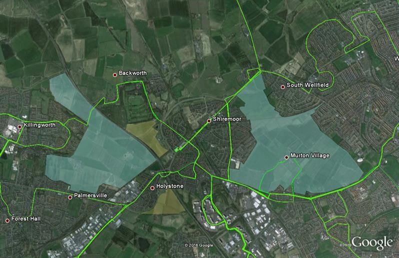
NTC Local Plan                  Commercial   in Confidence
      May 2016
                                                        Contents

7.2 Ashington, Blyth & Tyne Railway                         35
7.3 Cobalt Link Metro Extension                             35

                                                                 ii
NTC Local Plan                          Commercial   in Confidence
                                   May 2016
                                                                                             Contents

        Quality Management
Job No             CS/085561

Project            NTC Local Plan

Location           North Tyneside

Title              Public Transport Demand Scoping Study

Document Ref       CS/085561 Reports                Issue / Revision       1/C

File reference     A:\Transport schemes\NORTH TYNESIDE PARTNERSHIP\DCLG - Murton\Report

Date               May 2016

Prepared by 1      Peter Granlund                   Signature (for file)

Checked by         Faye Styles                      Signature (for file)

Authorised by      Stuart Clarke                    Signature (for file)

Revision Status / History
Rev        Date    Issue / Purpose/ Comment                 Prepared       Checked        Authorised

1          04.16   Draft                                    PG             NB

2          05.16   Final Draft                              PG & FS        FS             SPC

3          05.16   Final                                    FS             MP             SPC

                                                                                                       i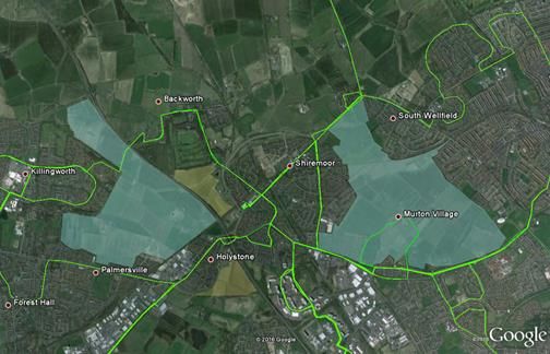
NTC Local Plan Commercial in Confidence
May 2016
1/ Background
1. Background
1.1 North Tyneside Local Plan
North Tyneside Council (NTC) are progressing the preparation of their Local Plan for the 15 year
period between 2017 and 2032. As part of this process, an Infrastructure Development Plan (IDP)
is being prepared to identify the major infrastructure improvements that are necessary to
accommodate the Local Plan proposals.
As part of the Local Plan, NTC has earmarked two strategic sites for residential development at
Murton Gap and Killingworth Moor that equate to half of the total Local Plan housing allocation
that is yet to be consented. Fully occupied, the sites will be resident to nearly 12,000 people
representing 5% of the projected borough resident population by 2032.
Capita has developed a strategic SATURN model covering the entire North Tyneside Borough to
test the Council’s emerging Local Plan for the 15 year period. The SATURN model has been
used to quantify the impacts of the preferred Local Plan options, to test the overall impact on the
highway network of the proposed strategic sites at Murton Gap and Killingworth Moor, and test
the proposed highway mitigation and phasing of mitigation required to deliver the two strategic
sites.
1.2 Murton Gap & Killingworth Moor Strategic Sites
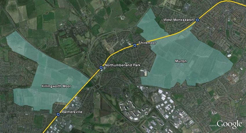
The Murton Gap site is located to the east of the A19 corridor surrounding Murton Village. The
site is bounded by Shiremoor to the west, Wellfield to the north, Monkseaton to the east and New
York to the south. The Metro line extends along the northern boundary of the site, with the nearest
Metro stations being at Shiremoor to the west and West Monkseaton to the east. The site is
allocated for housing to a capacity of 3,000 houses and the masterplan incorporates the provision
of a primary school initially proposed in the south of site adjacent to New York.
The Killingworth Moor site is located to the west of the A19 corridor between Killingworth and
Holystone Village. The site is bounded to the north east by the A19, Killingworth Village to the
west, Palmersville to the south and Holystone Village to the south east. The Metro line extends
along the southern boundary with the nearest Metro stations being Palmersville to the west and
Northumberland Park to the east.
The site is allocated predominantly for housing to a capacity of 2,000 houses, with the potential
for some office/business employment uses to support local job creation, to be accommodated in
the south of the site. Also incorporated within the masterplan for the site is a combined primary
and secondary school.
NTC’s IDP includes the provision of new Metro stations at Murton Gap and Killingworth Moor to
cater for new residential populations that would occupy the strategic sites. At Murton Gap, a new
station is proposed to be located on the northern boundary of the site, with a new north-south
highway crossing the Metro line providing a through route at the site. At Killingworth Moor, a new
Metro station is proposed to be located on the southern boundary to link with an existing footpath
south of the existing Metro line.
1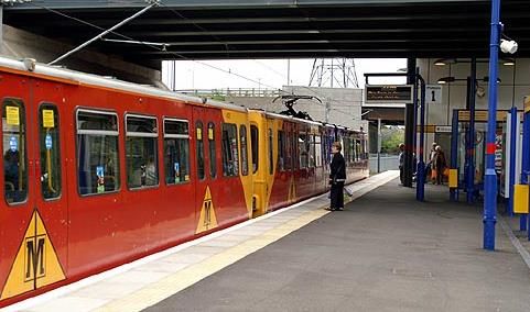
NTC Local Plan                                 Commercial  in Confidence
                                May 2016
                                                                                          1/ Background

      In addition to the delivery of Metro stations at the two strategic sites, the delivery of improved light
      rail services in North Tyneside is further enhanced by Nexus’ own aspirations for the Metro
      system outlined in the draft 2030 Metro Strategy document and reviewed in detail in this report.

1.3   Strategic Sites Population Forecasting
      As part of the Local Plan preparation there has been significant work undertaken on population
      forecasting and age profiling. Table 1 on the following page provides an outline of the population
      forecasts for the Murton Gap and Killingworth Moor sites.

      An upper and lower estimate of each site is provided and the upper estimate is based upon an
      assumption that all properties are built and occupied. The rate of occupancy is broadly equivalent
      to the rate observed at the 2011 Census at the new homes completed over the last 15 years at
      Northumberland Park in North Tyneside. The lower estimate has assumed that a maximum of
      3% of homes would be vacant due to sales etc. and has incorporated an average rate in decline
      of household size, informed by the borough wide household and population forecasts prepared
      by Edge Analytics for NTC.

      The age profile applied to the population at Murton Gap and Killingworth Moor is based upon an
      average between the 2011 profile at Northumberland Park and the Borough Wide Forecast for
      2032. Whilst an approximation, use of these averages enables the estimate to consider the
      anticipated disparity between likely occupiers of new homes and the borough wide age profile by
      2032 at the two strategic sites. This is deemed the most appropriate methodology of using
      existing population statistics to determine the likely future population profiles for the two strategic
      sites.

                                                                                                            2
NTC Local Plan                          Commercial  in Confidence
                               May 2016
                                                                                  1/ Background

       Table 1 Summary of Population in 2032
                                        All Ages    0 to 4   5 to 11   12 to 16     17 to 18   19 to 24   25 to 44   45 to 64   65 plus

Murton Gap
                                         7,064       596       577       327          117        468       2,595      1,447       937
(upper estimate)

Murton Gap
                                         6,504       548       531       301          108        431       2,389      1,333       862
(lower estimate)

Killingworth Moor
                                         4,795       404       392       222           79        318       1,761       982        636
(upper estimate)

Killingworth Moor
                                         4,386       370       358       203           73        291       1,611       899        581
(lower estimate)

Age profile in % on site at 2032         100%        8%        8%        5%            2%        7%         37%        20%       13%

                                        All Ages    0 to 4   5 to 11   12 to 16     17 to 18   19 to 24   25 to 44   45 to 64   65 plus
                                       224,124     11,501    16,545    12,012       4,761      12,937     55,499     55,127     55,742
Borough Wide Forecast Age Profile        100%        5%        7%        5%            2%        6%         25%        25%       25%
                                         1764        207       158        69           21        132        859        289        29
Observed Age Profile
Northumberland Park 2011                 100%        12%       9%        4%            1%        7%         49%        16%        2%

                                                                                                                                    3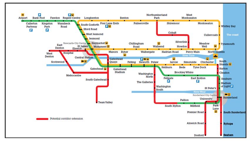
NTC Local Plan                                Commercial   in Confidence
                               May 2016
                                                                                         1/ Background

1.4   Sustainable Travel at the Strategic Sites
      The age profiling estimates shown in Table 1 demonstrate that a high proportion of the residents
      anticipated to reside at the two strategic sites will be of working age and will therefore, require
      appropriate and desirable public transport links that can realistically transport them to
      employment hubs in North Tyneside, such as the Cobalt and Quorum Business Parks, as well as
      other employment destinations like Newcastle city centre and Sunderland.

      Therefore, one of the fundamental transport objectives of the strategic sites is to maximise travel
      by public transport and it was agreed early in the Local Plan process that NTC would seek to
      adopt the strategy of providing a high quality level of service for active travel and public transport
      at key strategic sites in the borough, where the opportunity to influence travel behaviour is
      greatest.

      Capita has developed the North Tyneside Local Plan Strategic Sites Pedestrian & Cycling Study
      in April 2016 as part of the emerging Local Plan. This has assessed the pedestrian and cycling
      infrastructure in and surrounding the Murton Gap and Killingworth Moor strategic sites, and
      identification of key trip attractors surrounding the sites to determine infrastructure improvements
      required to link the sites to destinations by foot and bike.

      To supplement the active transport review undertaken in the pedestrian and cycling study, this
      report examines existing public transport availability and accessibility at the Murton Gap and
      Killingworth Moor strategic sites and reviews a range of public transport options for the site. The
      conclusions of this study have assisted in the formulation of the trip generation for Murton Gap
      and Killingworth Moor used in the development of the SATURN model to test the traffic and
      highway impacts of the two strategic sites.

1.5   Purpose & Structure of the Report
      This study seeks to examine the feasibility of various options for public transport provision at the
      two strategic sites for residential development identified as part of the emerging Local Plan. This
      includes the viability of proposed new Metro stations, a review of existing bus services, and
      appraisal of new routes to link the strategic sites with key destinations in Tyne and Wear.

      Consideration will also be given to how public transport measures associated with the strategic
      sites dovetail with external and wider public transport development schemes within the region.

      The report is structured into the following sections:

          1.   Review of Existing Public Transport Provision;
          2.   Identified Constraints of Metro Use;
          3.   Proposed Public Transport Scheme for Strategic Sites;
          4.   Metro Feasibility: Demand Forecasting;
          5.   Bus Provision; and
          6.   Future Public Transport Developments.

                                                                                                          4
NTC Local Plan in Confidence
Commercial
May 2016
2/ Review of Existing Public Transport
Provision
2. Review of Existing Public Transport
Provision
2.1 Metro Connections
The Metro system currently runs adjacent to both strategic sites, in each instance forming part of
the site boundary. The Metro line directly serves Newcastle city centre, Gateshead, South
Tyneside and 17 stations within North Tyneside, with connections available to Sunderland and
Newcastle Airport.
During peak periods, services operate every 12 minutes in either direction, with 15 minute
headways during off-peak periods. Additional services operate between Monkseaton and
Newcastle city centre during weekday morning and afternoon peak periods, increasing service
frequency to approximately every 6 minutes (this is an ‘average’ headway – additional services
are added to the timetable in a non-uniform manner resulting in service headways between 3 and
9 minutes).
2.2 The Metro & Murton Gap
At Murton, the Metro runs along the northern boundary of the site. The nearest adjacent Metro
stations are West Monkseaton and Shiremoor. West Monkseaton station is located to the north
east of the strategic site, approximately 540m walking distance along proposed site linkages and
existing pedestrian routes. The journey time from West Monkseaton station to Newcastle city
centre (Monument station) is 23 minutes. There is no car parking provision for Metro users at this
station, and there are 13 secure cycle parking spaces provided by Nexus.
Shiremoor station is located to the north west of the site, approximately 470m walking distance
from the proposed site linkages and along existing walking routes. The journey time from
Shiremoor station to Newcastle city centre (Monument station) is 21 minutes. The station provides
a small number of parking spaces (20) which of free for Metro users, and there are 8 secure cycle
parking spaces.
2.3 The Metro & Killingworth Moor
The Metro line forms part of the southeast boundary of the Killingworth Moor site. The nearest
adjacent Metro stations are Palmersville and Northumberland Park. Palmersville station is located
to the south of the strategic site, approximately 310m walking distance along existing pedestrian
routes on Great Lime Road. The journey time from Palmersville station to Newcastle city centre
(Monument station) is 16 minutes. Palmersville station provides no car parking spaces, leading
to the latent issue of on-street parking along Great Lime Road adjacent to the Metro station. The
station provides 10 secure cycle parking spaces to support multi-modal use of the Metro from
Palmersville.
Northumberland Park station is located to the west of the strategic site, approximately 1000m
walking distance from the site along existing pedestrian routes. The journey time from
5NTC Local Plan in Confidence
Commercial
May 2016
2/ Review of Existing Public Transport
Provision
Northumberland Park station to Newcastle city centre (Monument station) is 19 minutes. The
station benefits from a 400-space multi-storey car park, charged at one pound per day which
forms part of the Metro Park & Ride scheme. 10 secure cycle parking spaces are provided at the
station for those undertaking multi-modal journeys.
Multi-modal journeys are furthered enhanced at Northumberland Park Metro station as the station
provides public transport interchange between Metro services and local bus services. A summary
of connecting services that are available from Northumberland Park Metro station is shown in
Table 2 below.
Table 2 Bus Services at Northumberland Park Metro Interchange
Bus Service Operator Service Termini Key Bus Service Stops
North Shields, Royal Quays,
Tyne Tunnel Trading Estate,
North Shields -
19 Go North East Silverlink, Cobalt,
Ashington
Cramlington, Bedlington,
Ashington
Arriva North Shields, Shiremoor,
North Shields -
53 Palmersville Metro,
Cramlington
Killingworth, Cramlington
Arriva North Tyneside Hospital,
Whitley Bay – Shiremoor, Killingworth,
54
Newcastle Quorum, Gosforth, Newcastle
city centre
Arriva Whitley Bay - North Tyneside Hospital,
59
Backworth Murton Village, Shiremoor
Arriva North Tyneside Hospital,
359 Marden - Backworth
Murton Village, Shiremoor
With regards to access to Northumberland Park Metro station, the A19 represents a major barrier
for potential users of the station from the strategic sites. Existing pedestrian and cycle access to
the station from the Killingworth area is via the A19 Holystone junction, a large signalised
roundabout providing interchange between the A19 motorway and local A-roads in the Holystone
area. Pedestrian routes through the interchange are not direct as those on foot are required to
navigate a number of crossing points to travel west-east through the interchange to access
Northumberland Park station. Furthermore, the route is non-convivial and um-comfortable for
pedestrians given the proximity of those on foot to high speed traffic on the A19 off slips, and on
occasions, on the circulatory carriageway of the roundabout itself.
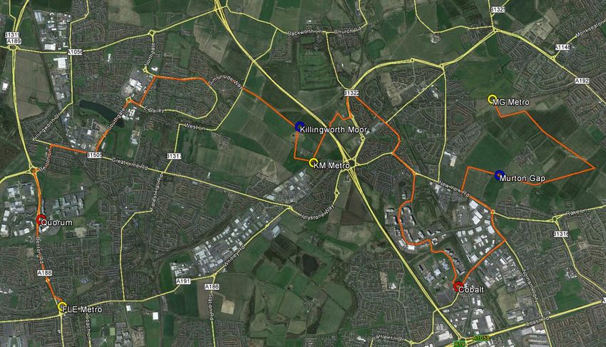
The locations of the existing Metro stations outlined above are shown in Figure 1 below.
6NTC Local Plan in Confidence
Commercial
May 2016
2/ Review of Existing Public Transport
Provision
Figure 1 Locations of Existing Metro Stations surrounding the Strategic Sites
2.4 Bus Accessibility
The Transport & Highway Supplementary Planning Document Local Development Document
(LLD12) for North Tyneside stipulates that distance targets for accessibility to public transport
nodes and infrastructure from a development is 400m in which routes are direct, convenient and
safe. The design of the Murton Gap and Killingworth Moore strategic sites and the specific
accessibility routes linking the development to the existing highway network are currently being
devised through various documents being compiled to support the emerging Local Plan.
Therefore, for the purposes of reviewing the existing bus services that operate surrounding the
strategic sites, bus nodes within 400m of the site boundary have been included in this study to
demonstrate current bus service provision.
2.5 Bus Services & Murton Gap
North Tyneside has a large network of bus services run by major operators. In many areas, routes
or sections of routes, duplicate those of other services and operators, resulting in a number of
heavily-trafficked bus corridors. In relation to the strategic sites, one such corridor is the A191
running along the southern boundary of the Murton strategic site.
As the strategic sites are earmarked for newly developed land, there are no permeable services
through either site; existing services operate around and adjacent to the sites. To the south of the
Murton site, the A191 is a major bus corridor with connections to Newcastle, Whitley Bay, North
Shields, Wallsend, Killingworth, Blyth, and Cramlington. The map in Figure 2 below highlights the
lack of permeable routes through the strategic sites.
7NTC Local Plan in Confidence
Commercial
May 2016
2/ Review of Existing Public Transport
Provision
Figure 2 Existing Bus Corridors around the Strategic Sites
Areas adjacent to the Murton Gap site are served well by existing bus services operated by Arriva
and Go North East, providing links to various key destinations in Newcastle, North Tyneside and
south east Northumberland, including employment, commercial, retail and leisure uses. The bus
services operational from bus stops located within 400m of the Murton Gap site boundary, and
the key service destinations and service frequencies are shown in Table 3 below.
Table 3 Bus Services surrounding Murton Gap Strategic Site
Frequency
Bus
Operator Service Termini (peak Key Service Stops
Service
period)
19 Go North North Shields – Every 15 Bedlington, Cramlington,
East Ashington minutes Shiremoor Metro, Cobalt
53 Arriva North Shields – Half hourly Killingworth, Palmersville
Cramlington Metro, Shiremoor
54 Arriva Whitley Bay – Half hourly Gosforth, Quorum,
Newcastle Killingworth, Shiremoor,
North Tyneside Hospital
59 Arriva Whitley Bay – Hourly Shiremoor, Murton Village,
Backworth North Tyneside Hospital
80 Go North North Shields – Half hourly Cobalt, North Tyneside
East Wallsend Hospital
309 Go North Blyth – Newcastle Every 15 Cobalt, Whitley Bay
East minutes
359 Arriva Marden – Hourly Shiremoor, Murton Village,
Backworth North Tyneside Hospital
8NTC Local Plan in Confidence
Commercial
May 2016
2/ Review of Existing Public Transport
Provision
2.6 Bus Services & Killingworth Moor
The level of service and frequency along routes adjacent to the Killingworth Moor site are
relatively poor, with most services providing links to the Killingworth Centre where passengers
can interchange onto direct bus services to Newcastle. The poor bus provision is reflected in the
local Census journey to Work data for the new Forest Gate estate which has only a 2% modal
split for bus use for commuting purposes.
The bus services operational from bus stops located within 400m of the Killingworth Moor site
boundary are shown in Table 4 below.
Table 4 Bus Services surrounding Killingworth Moor Strategic Site
Service
Bus Service Operator Service Termini Frequency Key Service Stops
(peak period)
51 Arriva Newcastle- Hourly Shiremoor Metro
Whitley Bay
53 Arriva Cramlington- Half hourly Killingworth,
North Shields Palmersville Metro,
Shiremoor
54 Arriva Newcastle- Half hourly Gosforth, Quorum,
Whitley Bay Killingworth,
Shiremoor, North
Tyneside Hospital
63 Stagecoach Newcastle- Every 15 Quorum,
Killingworth minutes Longbenton
2.7 Diversion of Existing Bus Services
Whilst Go North East has indicated a willingness to examine diverting existing bus services into
the Murton Gap and Killingworth Moor strategic sites, further detailed discussions will be required
with the operator to evaluate the operational and commercial impact of bus diversions, including
the financial viability and the impacts upon existing bus users in areas that are currently served
by such services.
9NTC Local Plan in Confidence
Commercial
May 2016
3/ Identified Constraints of Metro Use
3. Identified Constraints of Metro Use
3.1 Strategic Site Permeability
The National Planning Policy Framework encourages new developments to be supported by a
wide choice of permeable sustainable transport options to reduce environmental impact and
highway congestion associated with high levels of car use.
As demonstrated in Chapter 2, with the strategic sites earmarked for newly developed land,
neither site has public transport provision that could be considered ‘permeable’ as existing bus
services can only be accessed 400m outside of the site boundaries. The only exception to this is
Arriva’s service 59 from Whitley Bay to Backworth, which diverts from the A191 into Murton
Village along routes earmarked as link roads as part of the Murton strategic site development.
3.2 Connection Times
In general, connection times from the two strategic sites to existing Metro stations and bus stops
are disproportionately long compared to the onward journey times to likely destinations, such as
Newcastle city centre, and comparable car journey times, even in congested peak periods. The
following section quantifies this issue and the problem it represents.
3.3 Metro Catchment Areas
As already denoted in section 2.4 of this report, the design of the Murton Gap and Killingworth
Moore strategic sites and the specific accessibility routes linking the development to the existing
highway network are currently being devised through various documents being compiled to
support the emerging Local Plan.
Therefore, for the purposes of reviewing the existing Metro services that operate surrounding the
strategic sites, Metro nodes within specific distances of the site boundaries have been included
in this study to demonstrate current Metro service provision. Accurate routes and accurate
walking distances from within the proposed development sites cannot be ascertained at this time.
Nexus, the Tyne and Wear Passenger Transport Executive, defines a walking distance of 800m
as representing the catchment area of a Metro station. This equates to an approximate walking
time of 10 minutes, which is based upon an average walking speed of 5 km/h.
Table 5 below illustrates the shortest walking distances between the closest point on the strategic
site boundaries to the closest existing Metro stations using both current pedestrian linkages and
the linkages anticipated to be constructed as part of the strategic site developments.
10NTC Local Plan in Confidence
Commercial
May 2016
3/ Identified Constraints of Metro Use
Table 5 Minimum Walking Distances from Strategic Sites to Existing Metro Stations
Existing Metro station Distance Distance from
from Murton Killingworth Moor
Gap (m) (m)
Palmersville - 310
Northumberland Park - 860
Shiremoor 470 -
West Monkseaton 540
Analysis of the walking distances between the strategic site boundaries and existing Metro
stations show that areas of the Murton Gap site are within an acceptable walking distance of the
two nearest stations; Shiremoor and West Monkseaton. There are also areas within the
Killingworth Moor site that are shown to be within an acceptable walking distance to Palmersville
Metro station, but Northumberland Park is over an 800m walk from the strategic site.
Although both of the strategic sites are shown to be located with an acceptable walking distance
to at least one Metro station, these distances have been measured from the strategic site
boundaries to the stations, given that the permeability of the site in terms of the exact access
locations is currently being developed as part of the emerging Local Plan. When measured from
the centre of the site and along the specific access links from the site (when these are identifiable),
these distances will increase from those shown in Table 6 to account for the distance required to
walk from the centre of the site to the site boundary.
3.4 Metro Mode Share & Influencing Factors
Nexus’ Business Intelligence Annual Report 2009-2010 (BIAR) identifies that there is a correlation
between Metro mode share and walking distances to a Metro station. Metro mode share in
relation to walking distances to a station is shown in Figure 3 below.
Data in Figure 3 disaggregated into Census Output Areas (OAs) where residential housing was
present before the nearest Metro station was operational and those OAs created by new post-
Metro residential developments.
11NTC Local Plan in Confidence
Commercial
May 2016
3/ Identified Constraints of Metro Use
Figure 3 Metro Mode Share Comparison of Pre and Post-Metro Developments
25
Pre-Metro areas
20 Post-Metro developments
Metro mode share (%)
15
10
5
0
0 500 1000 1500 2000 2500 3000 3500
Walking distance to Metro station (m)
The results show that for OAs located within a 1000m walking distance to a Metro station, mode
share is generally higher in post-Metro residential developments when compared with residential
housing areas that were present before the Metro was operational.
Nexus’ BIAR demonstrates that there is also a relationship between Metro mode share and
parking spaces provided on-site at a Metro station to enable easy and efficient interchange
between car and Metro. This relationship is shown in Figure 4 below, which highlights that Metro
mode share is higher at those stations that provide vehicle parking than at those stations that do
not.
It is important to note that the dataset used to prepare Figure 4 below is the same dataset that
has been used in Figure 3 above. There are differences in the ‘Metro Mode Share’ upper limits
shown in the two Figures; 20% (Fig. 3) and 17% (Fig. 4). A number of stations were excluded
from the with-parking and without parking analysis (Fig. 4) because of ambiguity over whether
they actually represented a Metro station that provides on-site car parking. For example, Benton
Metro station was excluded for the analysis in Figure 4 because this station is advertised as
providing on-site car parking, but in actual fact can accommodate eight parked vehicles but this
does not include formal marked parking bays or spaces.
12NTC Local Plan in Confidence
Commercial
May 2016
3/ Identified Constraints of Metro Use
Figure 4 Metro Mode Share Comparison of Stations With and Without Parking Provision
18.0
16.0
Parking
14.0 No Parking
12.0
10.0
8.0
6.0
4.0
2.0
0.0
0 500 1000 1500 2000 2500 3000 3500
3.5 Opportunities for Improvement / Need for Change
Development of the two strategic sites will infill two geographical and spatial gaps in the North
Tyneside urban area. Currently undeveloped land, these sites have no permeable links and so
bus services in the borough have routed around the areas, creating the heavily-trafficked bus
corridors outlined earlier, namely the A191 corridor. Future development on the strategic sites,
providing new through links, affords an opportunity to reduce bus journey times between key
destinations outside the sites themselves.
Based on the analysis in section 3.3, while there is at least one Metro station within an acceptable
walking distance from both of the strategic sites, these distances will increase when measured
from the centre of the sites to include the walking distances along new pedestrian links built within
the developments that will link up to the existing highway network at the site boundaries. Such
distances can only be measured accurately on approval of the strategic site layouts.
Walking distances covering internal links within the strategic sites that will be in addition to the
minimum distances from the site boundaries to the nearest Metro station as outlined in Table 5
above, indicate that the majority of houses developed at the sites would not have an existing
Metro station with an acceptable walking distance.
The issue is further compounded by factors identified in Nexus’ BIAR research presented in
section 3.4. Potential Metro users living beyond a reasonable walking distance from the strategic
sites could use Metro Park & Ride schemes as part of a multi-modal journeys at Shiremoor, and
Palmersville stations. A lack of parking at these stations, however, can encourage whole-length
car journeys to be made as alternatives, or result in significant pressure on the highway network
13NTC Local Plan in Confidence
Commercial
May 2016
3/ Identified Constraints of Metro Use
and localised congestion that can arise with heavy levels of on-street parking as demonstrated at
West Monkseaton station where parking demand saturates the supply of available highway
parking.
14NTC Local Plan in Confidence
Commercial
May 2016
4/ Proposed Public Transport Scheme
for Strategic Sites
4. Proposed Public Transport Scheme for
Strategic Sites
4.1 Proposed Scheme
The proposed scheme to address the issues and constraints outlined in Chapter 3 involves the
following:
Provision of a new Metro station between Shiremoor and West Monkseaton stations to
serve the Murton strategic site;
Provision of a new Metro station between Palmersville and Northumberland Park stations
to serve the Killingworth Moor strategic site;
Car parking facilities to be provided at both new stations to provide Park & Ride
opportunities and facilities and to minimise on-street highway parking at the stations;
Secure cycle parking and storage at both stations to provide opportunities for sustainable
multi-modal trips by cycling and Metro, utilising proposed new cycle paths on the strategic
sites; and
Real-time passenger information, CCTV and Help Point.
Nexus’ research highlights the importance of the timing for delivering new Metro stations on the
network. The earlier the provision of a new station is made the larger the mode shift toward this
mode. It is easier to convert/persuade users to utilise the Metro if it is there prior to them relocating
to the new housing area. The later the Metro is provided the more established existing residents
will be in terms of their travel choices/mode.
The practicality of when to deliver a new metro station at Murton and Killingworth is linked to the
proposed/anticipated phasing of the strategic sites. As identified in the previous chapter there are
existing Metro stations adjacent the strategic sites that would part serve the site. If initial phases
were within reasonable distance of these existing stations (Palmersville, Northumberland Park,
Shiremoor, West Monkseaton) then need for the new station could be deferred. In conjunction
with this would be the prerequisite for sufficient internal site infrastructure to provide access to
the proposed new stations. At Murton this would be linked to the delivery of the main link road,
whereas at Killingworth the delivery of the new station is linked to the delivery of development
phases beyond reasonable walking distance of existing stations
An important factor concerning the delivery and integration of new Metro stations at the two
strategic sites is station accessibility. The North Tyneside Local Plan Strategic Sites Pedestrian
& Cycling Study (April 2016) outlines that safe and direct pedestrian and cycle links will be
provided to the new Metro stations from within the development sites themselves and linking to
external pedestrian and cycle infrastructure on the existing highway network. To supplement the
direct linkages, secure cycle parking and ramp accesses to platforms for disabled users will be
provided. Direct and convenient links to the new Metro stations will help to reduce walking and
cycling distances and encourage use of the Metro at the two strategic sites.
West Monkseaton and Palmersville Metro stations do not provide any on-site parking provision,
which according to Nexus’s research has been shown to inhibit the use of the Metro, as shown
in Figure 3 in Chapter 3.
15NTC Local Plan in Confidence
Commercial
May 2016
4/ Proposed Public Transport Scheme
for Strategic Sites
Contradicting this however, is the significant on-street parking that is evident surrounding West
Monkseaton station on Earsdon Road for example, which suggests that the Metro mode share
from this station has not been influenced by a lack of on-site station car parking. The highway
network along Earsdon Road adjacent to West Monkseaton station has been under pressure
from on-street parking associated with daily Metro use which has resulted in grass verges being
destroyed, footways being obstructed by vehicles, and localised congestion due to reduced traffic
speeds because of reduced road space.
These impacts have resulted in NTC recently introducing formalised parking bays adjacent to the
station to cater for parking demand. This is already at saturation daily and therefore, parking
demand at this station if it was to increase, would overtake the supply of available parking and
lead to further highway pressures. This station demonstrates the negative impact of highway
parking at Metro stations where parking spaces with the curtilage of the station site is not
provided.
The creation of new Metro stations at the two strategic sites should incorporate on-site car parking
provision to not hinder Metro use, as per Nexus’ BIAR research, as well as preventing adverse
impacts to the operation of the highway network associated with high volumes of highway parking
as demonstrated at West Monkseaton station.
4.2 Benefits & Impacts
The proposed public transport scheme will improve accessibility from the Murton Gap and
Killingworth Moor strategic sites to Metro and bus services. It will improve linkages between the
strategic sites and key employment areas in Tyne and Wear, reducing journey times and
encouraging sustainable travel to and from the sites. This contributes to improved access to a
range of employment, education and leisure facilities. Installation of car parks will provide
interchange for multi-modal and linked trips for those living outside acceptable walking distance
of the Metro stations, as well as reduce on-street parking pressures.
For example, the Murton Gap Metro station, located close to the A192, will be attractive to south-
east Northumberland residents commuting to places of work in Newcastle city centre and North
Tyneside. Killingworth Moor will attract commuters from east Killingworth.
In addition to the two strategic sites, there are planning permissions granted for a further 1040
residential properties in the vicinity of Palmersville and Northumberland Park Metro stations, at
Shiremoor West (590 homes) across the A19 from Killingworth Moor and Scaffold Hill (450
homes) south east of Holystone.
Demand at existing surrounding stations will be reduced as current Metro passengers transfer to
new stations that will be geographically closer to their place of residence. Demand abstraction
from existing stations that is likely to transfer to the new stations is summarised in Table 6 below.
Table 6 Metro Station Demand Abstraction
New Metro Station Demand Areas of Abstraction
Station Abstracted From
Murton West Monkseaton South Wellfield, Earsdon
16NTC Local Plan in Confidence
Commercial
May 2016
4/ Proposed Public Transport Scheme
for Strategic Sites
Killingworth Moor Palmersville Killingworth Village, east Killingworth, Benton
Square Industrial Estate, Scaffold Hill (future
development)
4.3 Impact of Not Changing
Assuming full occupation of each of the two strategic sites, there will be 4,510 working age
residents living at Murton Gap and 3,062 at Killingworth Moor. Without new or revised public
transport provision, large numbers of car trips will be generated and the local highway network
will be adversely affected by increased congestion, queuing, and journey time delays.
The local highway network is already heavily congested around both sites at peak travel times.
The proximity of Cobalt Business Park to the south west of the Murton Gap site attracts and
produces large amounts of peak period traffic along the A191 corridor to the south of the Murton
site. The Killingworth site is located adjacent to Great Lime Road and Killingworth Way, both of
which experience commuting related congestion during peak travel periods, including high
volumes of traffic destined for Quorum Business Park.
Without provision of new Metro stations, residents of the strategic sites are likely to use cars for
the whole of the commuting journeys, or at the very least to access existing stations along
congested highway links. Use of existing Metro stations will require lengthy walks or involve Park
& Ride using car parking spaces where provided, and will generate on-street parking on the
highway network at stations where no parking is provided.
Access to existing Metro stations is also via congested highway links, for example,
Northumberland Park Metro station is accessible via the congested A191 corridor, and additional
traffic travelling to the stations would contribute to significant amounts of additional traffic
congestion on highway links. The need to inhibit potential car trips at source becomes apparent
and strengthens the case for on-site Metro provision at the two strategic sites.
4.4 Bus Service Improvements
The proposed new Metro stations for the two strategic sites will provide public transport links to
key employment, commercial, retail and leisure areas in North Tyneside and further afield.
However, origin-destination projections for the two strategic sites show a number of areas
attracting significant journey to work trips, areas that are not currently served by a Metro station
within a reasonable walking distance (25 minutes).
Table 7 below shows the number of residents of each strategic site projected to make daily
Journey to Work trips to the Cobalt Business Park/Silverlink employment area. This has been
derived from population estimates for the strategic sites and 2011 Census data for the
Northumberland Park area, which offers the most appropriate representation of where strategic
site residents are likely to work, and therefore, make commuting trips to. LSOAs 11D, 15A and
15D geographically represent the Cobalt Business Park and Silverlink employment corridor
stretching from West Allotment to the A1058 Coast Road.
17NTC Local Plan in Confidence
Commercial
May 2016
4/ Proposed Public Transport Scheme
for Strategic Sites
Table 7 Journey to Work Trips from the Murton Gap & Killingworth Moor Strategic Sites
Murton Gap Killingworth
NT LSOA
Trips Moor Trips
11D 104 70
15A 186 126
15D 101 68
Total 391 264
Table 7 shows that on a typical weekday it is estimated that 391 and 264 commuting trips will be
made by residents from the Murton Gap and Killingworth Moor strategic sites respectively, to the
Cobalt Business Park/Silverlink employment corridor.
A second area attracting Journey to Work trips is the western half of Killingworth (8B, 8C and
8D), incorporating the Killingworth Centre, Camperdown, and the industrial areas along the
B1505 Station Road. Walking access to these areas from the nearest Metro stations at Four Lane
Ends and Benton is between 40 and 55 minutes.
Without a new bus service to link these attractor LSOAs that are not served by the Metro system,
the envisaged impact is that these short trips will be undertaken by car. Whilst the Metro system
serves some major employment areas well, the Quorum and Cobalt Business Parks are more
reliant upon access by road and access by public bus services. Provision of new bus services
should consider inclusion of these two large business parks as well as the Murton Gap and
Killingworth Moor strategic sites. Delivering public transport provision at the strategic sites
provides additional opportunities to re-route existing bus services to improve access to
fundamental employment and job creation areas in North Tyneside.
18NTC Local Plan in Confidence
Commercial
May 2016
5/ Metro Feasibility: Demand
Forecasting
5. Metro Feasibility: Demand Forecasting
5.1 Demand Forecasting Methodology
For the purpose of demand forecasting, each strategic site has been subdivided into geographical
areas, approximate in size to Lower Super Output Areas (LSOAs). Murton is represented as
‘North Tyneside 31’ with seven subdivisions (A-G) and Killingworth Moor as ‘North Tyneside 32’
with five subdivisions (A-E). These subdivisions represent areas approximately equal in size to
LSOAs.
The population of each LSOA has been estimated by applying an average of persons per
household figure (2.5ppp) to the proposed housing allocation in each area to determine average
number of people. A multiplier was applied to the total number of people in each LSOA, based
on Office of National Statistics projections for working age populations. This gives an overall
estimate as to the working age population in each LSOA by which to estimate the number of daily
journey to work trips made.
The same methodology has been used as that in the Metro Demand Study; a direct demand,
elasticity-based model. This model employs observed (historical) relationships between demand
and explanatory variables from historic data on the existing Metro network, combined with
additional evidence as required from comparable UK networks to estimate future-year demand.
This model assumes that the demand for the Metro between two locations is a function of a range
of variables relating to that trip, and these variables include fares, in-vehicle time, connection
times, service frequency, and the relative attractiveness of competing modes of transport such
as equivalent car journey times and parking costs.
Initially, a journey time matrix was developed for journeys between each 2011 Census LSOAs in
North Tyneside, including those LSOAs in the wider Tyne and Wear area that could be considered
to be within a reasonable walking distance of a Metro station, and therefore, within the catchment
area of the Metro system.
Each LSOA represents a zone in the demand matrix, with the population-weighted centroid
representing the centre of each zone. The component parts of each LSOA-LSOA journey, listed
in full in Table 8 below, were calculated for both Metro and car journeys.
Table 8 Journey Time Matrix Components
Journey time matrix components
Metro Car
Walking time to station (access) In-vehicle driving time
Walking time from station (egress) Fuel cost
At-station wait time Non-fuel cost
Interchange time between Metro Parking cost (where applicable)
services
Station-to-station fare Toll cost (where applicable)
19NTC Local Plan in Confidence
Commercial
May 2016
5/ Metro Feasibility: Demand
Forecasting
Components for each journey were translated into generalised cost (GC) using WebTAG
parameters for price-based components where necessary (WebTAG values used are detailed
below), and total GC for each LSOA-LSOA journey were derived. The difference in GC between
a Metro and equivalent car journey was then calculated.
Three existing North Tyneside LSOAs have been subject to demand abstraction of Metro trips
with the provision of the proposed new stations at the two strategic sites. Demand from LSOAs
7A and 7B, representing the areas encompassing South Wellfield and Earsdon, will transfer from
West Monkseaton station to the proposed Murton Gap station.
Similarly, demand from LSOA 18D which covers Holystone, will transfer from Palmersville station
to the proposed Killingworth Moor station. Future demand for Metro services from Scaffold Hill, a
major housing development of 450 homes with planning approval for development south of
Holystone, has been included in the demand forecast for the proposed Killingworth Moor station.
In relation to the Metro demand forecasting exercise, it is envisaged that the new Metro stations
would be operational at the strategic sites in 2018, prior to the housing to deliver post-Metro
developments following the analysis discussed in Chapter 3.
5.2 Metro Demand Forecasting Results
Table 9 on the following page illustrates the outcomes of the demand forecasting exercise. The
table shows the annual commuting trips that would utilise the proposed new Metro stations at the
two strategic sites up to the year 2032.
The graph in Figure 5 that follows Table 9 summarises the predicted annual Journey to Work
boarding projections at Murton Gap and Killingworth Moor stations in comparison to the most
recent new stations opened on the Metro system which are Simonside and Northumberland Park.
The projections demonstrate that the proposed Metro stations for the two strategic sites can
achieve annual Journey to Work patronage figures comparable to Northumberland Park station.
On completion of the strategic sites in 2032, the Murton Gap station has been estimated to
achieve annual Journey to Work boardings of over 175,000, with 145,072 boardings at the
Killingworth Moor station. This compares favourably with Northumberland Park station, which has
166,642 annual commuting boardings.
20NTC Local Plan in Confidence
Commercial
May 2016
5/ Metro Feasibility: Demand
Forecasting
Table 9 Metro Demand Forecasting for Murton Gap & Killingworth Moor Metro Stations
2018 2019 2020 2021 2022 2023 2024 2025 2026 2027 2028 2029 2030 2031 2032
Killingworth
Moor 39,349 46,536 53,717 60,894 68,065 75,214 82,363 89,504 96,636 110,711 117,604 124,487 131,359 138,221 145,072
Murton 49,650 55,081 61,901 68,753 75,657 81,842 88,066 96,125 104,232 112,389 124,760 137,208 149,736 162,343 175,031
Figure 5 Annual Journey to Work Boardings
200,000
150,000
100,000
50,000
0
2018 2019 2020 2021 2022 2023 2024 2025 2026 2027 2028 2029 2030 2031 2032
Killingworth Moor Murton Northumberland Park Simonside
21NTC Local Plan in Confidence
Commercial
May 2016
5/ Metro Feasibility: Demand
Forecasting
5.3 No Metro Demand Forecasting Results
No provision of new Metro stations at the two strategic sites would result in all those residents
aspiring to use the Metro as a means of travel, using existing stations; Shiremoor and West
Monkseaton for Murton Gap residents and Northumberland Park and Palmersville for Killingworth
Moor residents.
To forecast the number of new Metro journeys from the strategic sites at full development in 2032,
the Metro station catchment functions derived from Nexus have been applied to the projected
populations at each site. The centroids of each site’s LSOA has been used, with the walking
distance to the nearest existing Metro station derived. Possible walking routes include both
existing paths and future links proposed as part of the development of the strategic sites.
Results of demand forecasting for use of existing Metro stations, indicate that 294 daily trips
would be created from the Murton Gap site and 574 would be created from the Killingworth Moor
site. The forecast number of Journey to Work boardings from existing stations by residents of the
strategic sites is shown in Table 10 below.
Table 10 Daily journey to work trips from existing stations with no new Metro stations
Existing Metro Station Strategic Daily Journey to
Site Work Boardings
Shiremoor Murton 157
West Monkseaton Gap 137
Northumberland Park Killingworth 235
Palmersville Moor 339
5.4 Patronage Estimates for New Stations & No New Stations
Analysis of journey purposes by Nexus indicates that Journey to Work trips account for 47% of
all Metro trips. Applying this to the demand forecasting results presented in sections 5.2 and 5.3,
the total annual Metro trips generated by the strategic sites in 2032, including a breakdown of
which stations would cater for these trips, are summarised in Tables 11 and 12 below.
Table 11 Murton Metro Patronage Estimates for 2032
Annual patronage (2032)
Station With New Stations With no New Patronage Change with
Stations New Stations
Murton 371,065 n/a +371,065
Shiremoor 42,285 166,420 -124,435
West Monkseaton 27,193 145,220 -118,027
TOTAL 440,543 311,640 +128,903
22NTC Local Plan in Confidence
Commercial
May 2016
5/ Metro Feasibility: Demand
Forecasting
Table 12 Killingworth Moor Metro Patronage Estimates for 2032
Annual patronage (2032)
Station With New Stations With no New Patronage Change
Stations with New Stations
Killingworth Moor 307,552 n/a +307,552
Northumberland Park 0 249,100 -249,100
Palmersville 323,333 359,340 -36,007
TOTAL 630,885 608,440 +22,445
The tables above shows that with no new stations, 311,640 new Metro trips would be generated
by full development of Murton Gap strategic site, with 359,340 generated by Killingworth Moor.
New patronage would be distributed relatively equally between the two sets of existing stations
that would serve each site.
The provision of new Metro stations would create an additional 151,348 new Metro trips annually.
Murton Gap would abstract most demand from Shiremoor and West Monkseaton. The new Metro
station at Killingworth Moor would abstract all demand for Northumberland Park station, while a
substantial number of users would continue to use Palmersville station.
5.5 Revenue Estimates for New Stations & No New Stations
Using the estimated Metro patronage figures discussed in section 5.4 above, and applying an
average Metro ticket fare of £1.65, which has been derived using an average of all fares and
weighted by sales of each ticket type, an estimated annual revenue from new Metro patronage
can been calculated to provide a monetary context to the estimated patronage figures.
It is estimated that an increased annual revenue from new patronage of £249,724 at full strategic
site development in 2032 would be generated. Table 13 below summaries the increase in
revenue arising from new Metro patronage and total estimated revenue with new stations.
Table 13 Revenue Forecasts for Metro Stations
With New Stations With no New Stations Revenue Change
with New Stations
Total
£1,767,856 £1,518,132 £249,724
Revenue
5.6 Wider Benefits
The provision of new Metro stations at the two strategic sites will encourage modal shift from car
to Metro, subsequently reducing the number of vehicle journeys by road as well as providing
greater opportunity for walking and cycling trips to connect to stations. This will have quantifiable
benefits in terms of carbon reduction and health benefits associated with increases in active travel
in the borough. This would be determined as part of a full scheme business case in conjunction
with detailed analysis of highway network decongestion as a result of increased Metro patronage.
Providing new Metro stations at the strategic sites would link in with the proposed cycling and
walking improvements being developed as part of the strategic sites, which are discussed in
23NTC Local Plan in Confidence
Commercial
May 2016
5/ Metro Feasibility: Demand
Forecasting
greater detail in the pedestrian and cycle study prepared by Capita for the emerging Local Plan.
The internal links and routes that will be developed through the strategic sites will provide direct,
convenient and safe links from dwellings to the on-site Metro stations. These links will enable
sustainable interchange with the stations, allowing residents and users of the strategic sites to
make linked trips entirely by sustainable modes. Secure cycle parking facilities will be provided
at the Metro stations to encourage the use of bicycles to travel to and from Metro stations.
5.7 Assumptions Matrix
In determining generalised costs for Metro and car journeys, a number of assumptions have been
made where actual values were not available for each element. For example, when determining
car parking charges it has been assumed that for journey to work trips, a car user must pay any
hourly rate for the duration of a typical working day i.e. 8 hours.
Table 14 below summaries all of the assumptions made in determining generalised costs of
journeys including, where applicable, references to external values used.
Table 14 Assumptions Made in Journey Time Matrix Development
Element Methodology Data source(s), where Assumption(s), where
applicable applicable
Metro fare Average station-to-station fare Nexus submission ‘Revision to the Average fare between station
based on Metro fare zones and Metro and Ferry Fares 2016’ to pairs is average of all available
weighted by quantity of ticket types NECA Transport North East (Tyne ticket types, weighted by number
sold (based on Nexus Ticket and Wear) Sub-Committee, 24 of tickets sold of that type.
proposals for 2016-17, submitted to November 2015, Appendices B &
NECA). C.
Metro in- Station-to-station journey times Metro timetables on Nexus All Metro users travel on shortest
vehicle time based on Nexus/Metro timetables. website. route between station pairs.
Metro Shortest walking route derived from All Metro users will use
access/ Google Maps journey planner, from geographically closest station and
egress LSOA population-weighted centroid access station along shortest
to Metro station. route.
Average walking speed 5kmh
(WebTAG Unit 5.1/DMRB 11.8.3)
Metro wait Headway between services, divided Maximum wait time for service is
by two. half headway between services.
No operational delays.
Metro Number of interchanges required Transfer time between services
interchange between two stations. uniform across entire network.
All Metro users travel on shortest
route between station pairs.
Car parking Parking charges in each LSOA Whole working day parking
charges derived (multi-storey and on-street) duration.
from ‘Parkopedia’ website, full day
rate calculated.
Car tolls Tyne Tunnel usage fee of £1.60
applied to all car journeys where
fastest route is through tunnel.
24NTC Local Plan in Confidence
Commercial
May 2016
5/ Metro Feasibility: Demand
Forecasting
Value of All monetary figures translated into All monetary values associated All car trips are single occupancy.
Time (VoT) Value of Time in minutes, based on with trips translated into values of
WebTAG values/parameters for ‘Car time based on WebTAG
Driver’. parameters.
Value of ‘PSV Passenger’ values used for All monetary values associated
Time (VoT) Metro journeys. with trips translated into values of
time based on WebTAG
parameters.
Metro in- Increases in journey times to/from
vehicle time new stations offset by new Metro
fleet.
5.8 Park & Ride Opportunities
The draft 2030 Metro Strategy document recognises that attracting car users to the Metro for all
or some of their journeys will be a component of increased future demand. One way of achieving
this will be by the targeted expansion of Park & Ride sites in North Tyneside where demand exists
or is likely to do so in the future.
Park and Ride facilities at strategic locations will have an important part to play in widening the
reach of Metro across the region in this manner. Any new network extension proposals will also
seek to incorporate Park & Ride sites at the planning stage to fulfil a similar role.
Both of the strategic sites provide a strong opportunity to include Park & Ride provision as the
strategic link roads central to both sites will by definition serve users beyond the sites themselves.
At Murton Gap this would provide an opportunity to reach residents within south east
Northumberland (Seaton Delaval, Holywell, and Blyth). Many of these residents enter North
Tyneside via the A192 at Earsdon close to where the proposed link road would connect and cross
the Metro line within the Murton Gap site.
The Park & Ride opportunities at Killingworth Moor site would serve a more local catchment.
There is a latent demand for this provision as parking on Great Lime Road around the
Palmersville station is becoming an increasing problem due to a lack of appropriate parking
provision. Parking on the highway network demonstrates the opportunity for formalising a Park
& Ride scheme at this location.
The provision of parking facilities at Metro stations is shown to increase mode share by Metro
from all LSOAs using that station. Analysis shows that a parking facility increases Metro mode
share within reasonable distance of the station by up to 5%. The relatively short distances
between Metro stations, typically 1-2km, limits the potential to determine whether geographical
catchment areas of stations are affected by parking facilities; at more than reasonable distance,
it is difficult to differentiate from the catchment areas of adjacent stations.
Sensitivity testing has been undertaken to determine the effect on mode share if the proposed
Metro stations at the two strategic sites incorporate dedicated parking versus a scenario in which
no such parking facilities are provided. Figure 6 below shows mode share by Metro for stations
with and without parking provisions. Stations used that have parking facilities include
25You can also read