Floodplain Management Innovation to Facilitate City Growth - 2020 Floodplain ...
←
→
Page content transcription
If your browser does not render page correctly, please read the page content below

Floodplain Management Innovation to Facilitate City Growth

T Morrison, S Molino
   1. Molino Stewart Pty Ltd, Parramatta, NSW

Abstract

Parramatta is located geographically and demographically in the centre of Sydney and
is commonly referred to as Sydney’s second Central Business District (CBD). The
NSW Government and Parramatta City Council (Council) have identified Parramatta
CBD as a key growth centre for large scale commercial and residential development.
Over the next few years it is planned that tens of thousands of new residents and
workers will make Parramatta their base, facilitated by major new infrastructure
projects such as a new light rail system, and revitalisation of riverfront areas.

To facilitate this development Council has produced a draft Local Environment Plan
(LEP), which would allow much taller and larger buildings throughout most of the CBD.

However, one of the most significant constraints for development within the Parramatta
CBD is that the Parramatta River passes through the middle of the CBD, and most of
the CBD is within the floodplain of the River or its tributaries. In addition, the relatively
small catchment upstream of the CBD results in flash flooding i.e. less than six hours
notice of a forthcoming flood. Even with the current population of the CBD, this lack of
warning of an upcoming flood will cause significant evacuation problems, and the
proposed population increase will exacerbate this.

This paper presents the results of a project that used innovative planning controls and
design guidelines to facilitate the growth of the Parramatta CBD whilst ensuring flood
risks to people and property are appropriately managed. Council will consider the
implications of this project as it develops future plans for managing flooding in the CBD.

Introduction

The Parramatta CBD is currently undergoing significant growth and redevelopment.
The importance of a successful and growing Parramatta CBD to the growth of Sydney
as a whole was recognised by the NSW State Government, identifying it as a “CBD of
metropolitan significance” (NSW Department of Planning and Environment, 2014).

In response, Council has developed the Parramatta CBD Planning Strategy (the CBD
Strategy), which was adopted in April 2015. Key features are:
    - Expand the boundaries of the CBD;
    - Increase the floor space ratios in certain areas;
    - Alter solar access controls;
    - Alter building height restrictions; and
    - Expand the commercial core of the CBD.

An implementation strategy for the CBD Strategy has been developed, which includes
the development of a planning proposal to modify the Parramatta City Centre LEP
2007. In order for the planning proposal to be approved, a number of statutory
obligations need to be met. This includes the Section 117 Direction 4.3 – Flood Prone
Land of the Environmental Protection and Assessment Act 1979 (the direction). Clause
3 of the direction states, “This direction applies when a relevant planning authority

2016 Floodplain Management Australia Conference                                            1
prepares a planning proposal that creates, removes or alters a zone or a provision that
affects flood prone land”. The direction states what the planning authority must do in
this instance, with these requirements generally in line with the NSW Flood Prone Land
Policy and the Floodplain Development Manual (DIPNR, 2005).

One obligation is that a planning proposal should not permit a significant increase of
development within flood prone land unless the planning proposal is incorporated into a
Floodplain Risk Management Plan (FRMP) created in accordance with the principles
and guidelines of the Floodplain Development Manual (2005).

Council is currently creating a flood model for the Parramatta River catchment, which
will be used to develop a new FRMP, but this will not be available until around 2020.
As an interim measure Council has decided to update two existing FRMPs that each
cover a part of the CBD:
     - The Floodplain Risk Management Plan for the Upper Parramatta River
        Catchment, Bewsher Consulting for the Upper Parramatta River Catchment
        Trust (April 2003)
     - The Lower Parramatta Floodplain Risk Management Plan, SKM for Parramatta
        City Council (August 2005).

The updated FRMPs will include recommendations to amend planning controls for the
CBD as well as other floodplain management measures needed to minimise risk to life
and property.

This paper outlines the approach taken to assessing risk to life within the CBD and the
logic that was applied to develop a set of recommended planning controls and other
mitigation measures to manage the flood risks in the Parramatta CBD, both under the
current building size development controls and those proposed by the CBD Strategy.

Planning Proposal

The study area covered by this project is the planning proposal extent (Figure 1). This
area is a subset of the area of the two original plans, which cover a much larger part of
the Parramatta LGA.

Preliminary strategic planning analysis has identified the lots that are likely to be
subject to redevelopment as a result of the planning proposal. These are also shown in
Figure 1.

2016 Floodplain Management Australia Conference                                        2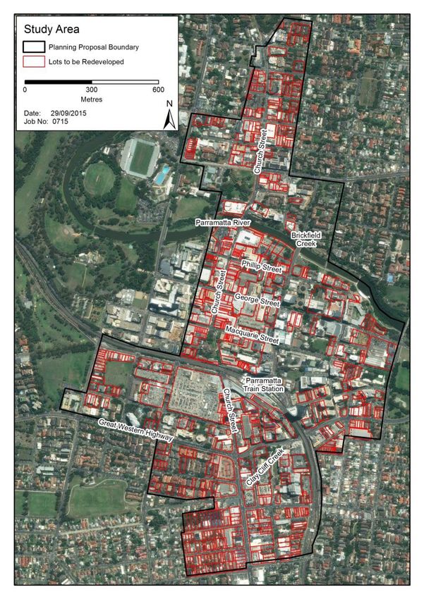
Figure 1: Planning Proposal Extent and potential redevelopment lots

While the current controls on the development within and around the CBD already
permit reasonably significant redevelopment of the planning proposal area, the
planning proposal would allow further intensification. Development of buildings up to
around 50 storeys is proposed within the core area, as opposed to the existing controls
which allow buildings up to around 30 storeys. Around the fringes it would allow

2016 Floodplain Management Australia Conference                                      3
buildings between 10 and 30 storeys, whereas five storey buildings are currently
allowable.

Given the current and projected demands for space within the Parramatta CBD area,
all redevelopment is likely to be for the construction of either commercial or residential
“high rise” buildings.

Flood Hazards

Currently available flood data for the CBD includes:

   -   Flood extents for the 1 in 20 and 1 in 100 chance per year design floods, and
       the PMF; and
   -   MIKE 11 modelling of the upper and lower Parramatta River

While a two dimensional hydrodynamic model of the whole of the Parramatta River and
its tributaries is currently being built, the outputs are not expected to be available until
2019. As such, this project used the available flood data.

Flooding affects the study area in a number of ways. Within the heart of the CBD local
overland flows can exceed the capacity of the drainage network and cause low hazard
ponding in low spots within the road system. In events up to the 1 in 20 chance per
year flood the Parramatta River is generally confined to a narrow band of open space
along the river banks that is crossed by several road and pedestrian bridges. In a PMF
the flooding is more extensive, deeper and faster flowing and can get up to several
metres deep across wide areas of the CBD.

Brickfield Creek to the north and Clay Cliff Creek to the south are two significant
tributaries that can be subject to serious flooding from rainfall within their own
catchments. Within the CBD extent along Clay Cliff Creek there is considerable
existing development below the 1 in 20 chance per year and the 1 in 100 chance per
year flood levels.

Figure 2 shows the extents of the 1 in 20 chance per year flood, 1 in 100 chance per
year flood and the PMF.

Flooding in the Parramatta CBD is typical of flash flood catchments. Floods arrive
quickly and without significant warning time and then recede quickly. The average flood
duration is less than five hours even in extreme floods. A flood warning system for the
CBD is currently being investigated and may eventually form part of the flood risk
management arrangements for the CBD.

2016 Floodplain Management Australia Conference                                           4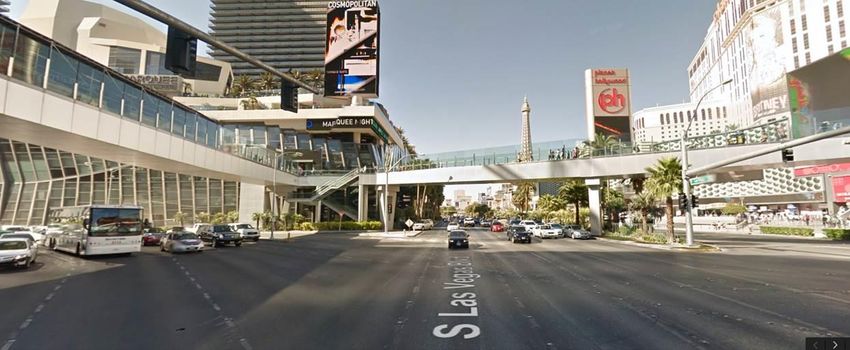
Figure 2: Flood Extents through the study area

2016 Floodplain Management Australia Conference   5
Population at Risk
For floodplain management within the Parramatta CBD, the most important
consideration is risk to life, especially given that even under existing development
controls it is projected that population will increase considerably.
Statistics are not available to determine current population in the CBD but there are
about 20,000 people living in the suburb of Parramatta (ABS 2011), a proportion of
which will be in the CBD. In addition, the current economic output of the CBD places it
at sixth position in Australian CBD’s (after Sydney, Melbourne, Brisbane, Adelaide and
Perth).
Council estimated the future CBD population for full development under the current
planning controls and two alternative future scenarios. In one scenario, residential
development is not allowed in the commercial core (FSAR1), and in the other it is
(FSAR2). Each fully developed scenario population would be a substantial increase on
the current population:
- Existing Controls:
o 35,048 Commercial
o 19,576 Residential
- FSAR1:
o 92,253 Commercial
o 58,961 Residential
- FASR2:
o 76,096 Commercial
o 68,000 Residential
For flood risk planning purposes, the entire commercial population and the entire
residential population are unlikely to be occupying the CBD at the same time. During
business hours most of the residents will not be at home and when most of the
residents are at home (at night) most of the businesses will be closed.
There will also be a third population in the CBD during office hours and they are visitors
who are not counted in either the commercial (employed) or resident populations.
Visitors include patrons of commercial premises, people in the CBD to do business and
school or college students. There are no estimates available for what this current or
future population is but this population is likely to be large and will increase in the
future, with more tourism offerings such as an upgraded River Foreshore, relocated
Powerhouse Museum, and improved infrastructure such as a light rail system. Finally
large numbers of people can be present during major events such as New Year’s Eve,
when it has been estimated that 50,000 people watch the fireworks from the foreshore.
Flood Risk Assessment
As per the requirements of the Section 117 Direction 4.3A, a flood risk assessment was
undertaken on the CBD Strategy planning proposal. This involved the following steps:
- Describing the flood behaviour;
- Determining the emergency response classification;
- Defining the risk tolerability thresholds;
- Identifying risk reduction measures; and
- Developing and mapping the flood risk categories.
Flood Behaviour
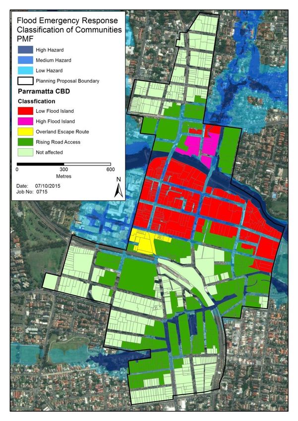
2016 Floodplain Management Australia Conference 6Describe flood behaviour proved challenging with the limited flood and terrain data available. It was possible, with some data manipulation, to determine the extent of the: - 1 in 20 chance per year flood peak; - 1 in 100 chance per year flood peak; and - PMF peak, as well as its depth and duration. Emergency Response Classification The NSW SES, in conjunction with the NSW Office of Environment and Heritage, has developed a topographic classification system known as the “Flood Emergency Response Classification of Communities” (2007). The classification indicates the flood risks associated with topography and assists the NSW SES and other floodplain managers to determine which areas should be given priority for evacuation and what challenges the topography may present. For example, a “low flood island” is where the evacuation route for an area is cut before it is inundated. These areas are generally high risk because if people fail to evacuate until it is apparent their premises are in immediate danger, it will be too late and they may need to be rescued. A “high flood island” is similarly isolated by flooding, however the occupants could still escape to an area above the flood waters. “Areas with rising road access” are of less concern, as the occupants can still evacuate by vehicle or on foot along a formed roadway even if they evacuate late. Similarly, “areas with overland escape routes” may not have rising road access but at least they will be able to escape on foot to areas above the level of the PMF. The classification was undertaken for the Parramatta CBD, based on ground levels. The results are shown in Figure 3. It should be recognised that buildings in areas classified as low flood islands are effectively high flood islands if they have internal access to areas above the reach of the PMF. Similarly, apartments and offices above the ground floor in areas classified as having rising road access or overland escape routes effectively become flood islands if people fail to evacuate when the ground floor of the building is threatened by flooding. Risk Tolerability Thresholds Tolerability thresholds were defined in relation to flood probability, duration and depth and these and the emergency response classification used to guide planning controls. Ideally, more parameters should be used including flood hazard classification but this project was limited by available data. The concepts of acceptable, tolerable and unacceptable risk are ones which this paper does not have the space to explore. Discussion on those in relation to flooding can be found in Molino et al (2012). Another important concept for a risk to life assessment is the difference between individual risk and societal risk acceptability and tolerability thresholds. Again space does not permit a lengthy discussion here. A way of illustrating the concept is that each year on Australian roads hundreds of individuals die in hundreds of separate accidents. While society does not see the fatality rate as acceptable, we tolerate the risks to individuals, including ourselves, because of the benefits that fast, efficient road 2016 Floodplain Management Australia Conference 7
transport brings. We support measures to reduce the individual risk but realise that
some risk remains. However, if a single plane crashed every 10 years killing 300
people, society finds this much less acceptable even though the individual risk of a
person dying in the plane crash is less than their individual risk of dying in a car crash.

Figure 3: Flood emergency response classification of communities across the CBD

For this project there was insufficient information available to undertake a quantified
societal or even individual risk assessment. Therefore a qualitative approach was

2016 Floodplain Management Australia Conference                                          8
taken to identifying measures to reduce individual risk using quantified thresholds of
contributors to individual risk based on the limited available data. For example, a
building which is isolated by high hazard floodwaters for several hours in a 1 in 20
chance per year flood presents a much higher risk than were the same building to be
isolated by low hazard floodwaters for less than an hour in a PMF. The planning
proposal provides the opportunity to guide development in areas which place people
and property at the greatest risk from flooding and to impose planning controls to
reduce the residual risk to life.

Evacuate or Shelter in Place?

It is always preferable for individuals to evacuate out of a floodplain ahead of
floodwaters arriving, rather than sheltering in a location that is isolated by floodwaters.
The existing planning controls are designed to facilitate pedestrian and vehicular
evacuation to a level above the PMF in events up to the 1 in 100 chance per year flood
from commercial premises and in all events for residential premises. The driveway
access provisions imply that vehicles should be able to drive off site in events up to the
1 in 100 chance per year flood level.

Notwithstanding this general preference for evacuation rather than shelter in place, for
the specific location of the Parramatta CBD the available data shows that:
    - There may be less than one hour flood warning on the Parramatta River and
       even less warning time on its tributaries;
    - Many of the CBD streets will be blocked by flooding in a 1 in 20 chance per
       year flood;
    - Many parts of the CBD are flood islands;
    - Even where there is rising road or pedestrian access to an off site area above
       the PMF, the fact that development will be high rise may mean that access from
       the building effectively is cut before occupants know they need to evacuate; and
    - The CBD road capacity is insufficient to evacuate all vehicles from the CBD
       before being overwhelmed by floodwaters.

In light of the above, it was decided that sheltering in place was the most practical
and safest option for any proposed high rise development.

Having said that, it is still preferable to encourage development that minimises the
chance that people will be frequently isolated in buildings for long periods of time
because they may:
   - try to leave (or enter) the building through hazardous floodwaters despite advice
      to the contrary;
   - need medical assistance; or
   - need to evacuate from a fire.

Duration of Isolation

The duration that people are willing to shelter in place will vary depending on their
circumstances. As a general rule people are more willing to shelter for a longer
duration in their own home than they would be in commercial premises. Additionally,
flooding will not just be a barrier to people leaving buildings, but will also affect people
trying to enter buildings. There is also ample evidence that people can make poor
decisions about their capacity to safely traverse floodwaters. For these reasons, the
duration of isolation needs to be kept short.

2016 Floodplain Management Australia Conference                                           9
The NSW SES Timeline evacuation model suggests that it takes about two hours for a person to be ready to evacuate after being given an evacuation order (Opper et al 2009). It was intended to use this as the first threshold for classifying areas based on duration of isolation because in shorter duration flooding there would be a very low probability that people would decide to cross high hazard floodwaters. However, the available data would only show durations above or below three hours for the PMF. As such, three hours was used as the first threshold for Parramatta CBD. The second threshold adopted was eight hours, as this represents the duration of an average night’s sleep or a work shift. As such, there is a chance that flooding of this duration will not necessarily inconvenience people who enter or exit a building and they may not need to do so while flooding is occurring. However, isolation for eight hours presents a greater risk to building occupants than isolation for three hours. Isolation for more than eight hours represents the greatest risk to occupants. Flood Hazard While hazard is traditionally determined from depth and velocity combinations, the lack of velocity information meant that for this project only depth was used. Here the criterion adopted was depth of flooding in the PMF, as this represents the worst case scenario. Two depth thresholds were considered and were based on the most recent Australian research in this area (McLuckie et al, 2014). A 0.6m threshold was used to represent the depth above which it would be difficult for emergency service vehicles to reach buildings. A depth of 1.2m was used as the other threshold as above this depth it is difficult for adults to traverse low velocity flood waters. Flood Probability Probability of flooding as a criterion was based on the available modelled flood extents which were limited to the 20 year ARI (5% AEP), 100 year ARI (1% AEP) and the PMF. Flooding above the 100 year ARI (5% AEP) would require the greatest controls to manage risk to life. Risk Reduction Measures There were a variety of risk reduction measures identified for the Parramatta CBD that could reduce the risk to life and property from the direct and indirect effects of flooding. High Rise Development High rise redevelopment within Parramatta CBD, particularly where it replaces one and two storey buildings, itself is a flood risk reduction measure. This is because if there was an existing population on a low flood island, when the building is converted to a high rise building that population will increase, but the building will also convert from a 2016 Floodplain Management Australia Conference 10
low to a high flood island. This means the population at risk will increase but the risk to
individual occupants decreases.

While minimum habitable floor levels for residential development will continue to be
specified as above the 1 in 100 chance per year flood plus 500mm freeboard, the
current practice within the CBD is that all residential towers will have commercial
development on the ground floor. It would also be possible to specify minimum ceiling
heights for the commercial development which would effectively put all new residential
development above the reach of the PMF.

Lot Consolidation or Connection

While an individual building on an individual block may have a particular flood risk, if a
group of buildings or a collection of lots are considered as a whole the exposure and
classification may be different. For example, if a building faces a street which has a
1 in 20 chance per year of being flooded then the building has a higher probability of
being flooded than say a building behind it which faces a street with less than a
1 in 100 chance per year of being flooded. If the first building has access through the
building behind it then the risk is reduced.

A broad scale redefinition of floor space ratios, building heights and development
controls offers the opportunity for redevelopment to be considered at a precinct level
rather than individual developments. This may provide building construction
opportunities that collectively change flood risk by providing building access at a point
of low flood probability. This could be done through the consolidation of lots for a
single development or by the linking of developments by elevated pedestrian bridges.
The latter is not uncommon around the world (eg Figure 4), and even occurs in
Parramatta e.g. at Westfield Parramatta.

Figure 4: Example of elevated pedestrian network in Las Vegas

2016 Floodplain Management Australia Conference                                         11
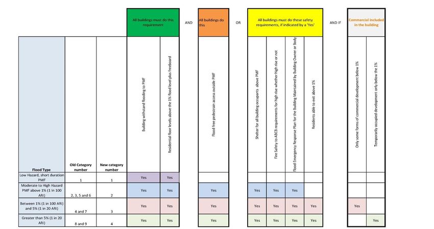
Fire Risk Reduction

Many of the existing buildings in the CBD were constructed prior to current building fire
safety standards or their size means they do not have to have the highest standards of
fire suppression and response. Given that in longer duration isolation there may be a
loss of power supplies and the risk of fire increased due to the use of improvised
lighting or heating, it would be advisable to impose the highest standards of fire
management where the risk of relatively prolonged isolation by floodwaters is high.

It would also be possible to specify that fire doors need to provide an exit from the
building at a level higher than ground level where the probability of flooding is high.
This would avoid the current situation of buildings whose fire doors may lead directly
into floodwaters and may be completely inoperable if they cannot be opened against
the external water pressure. External stairs would be required for the final part of the
fire evacuation infrastructure.

Prevention of Vehicular Evacuation

The focus of existing planning controls is on maintaining the availability of access to
and from buildings up to the 1 in 100 chance per year flood level. The new objective is
to discourage evacuation because it is recognised that in the CBD the building egress
may be flood free but the entire city block may be a low flood island. The provision of
devices which automatically prevent exit from carparks when flood levels reach a
certain threshold would eliminate the risk of people driving out of buildings and into
floodwaters. If they cannot drive out of the building, people are more likely to stay in
the building until the flooding subsides.

Prevention of Entry to Flooded Car Parks

The existing planning controls require protection of car parks up to the 1 in 100 chance
per year flood level and protection of basement car parks up to the PMF level. These
controls are sometimes difficult to practically implement and the focus could be moved
to preventing people entering car parks threatened by flooding. This could be linked
with the measures to prevent vehicles leaving the car park.

Owner and Body Corporate Requirements

Redevelopment provides the opportunity to impose conditions on the building owner or
body corporate to maintain flood risk reduction measures, as per legal obligations to
maintain building fire safety.

Flood Risk Categories

Using the emergency response classifications and the tolerability thresholds described
above, nine flood risk categories were developed and mapped for the Parramatta CBD.
To each was applied a set of risk management measures commensurate with the
qualitative estimate of risk to life. Table 1 shows the first pass results.

2016 Floodplain Management Australia Conference                                       12
While the rationale for the risk to life categories is sound and the suggested
management measures in Table 1 are appropriate, the use of nine separate life risk
categories in a planning scheme is impractical.

Furthermore, the fact that most, if not all, of the redevelopment which will take place in
the CBD will be multi-storey, there will be little practical distinction between rising road
access and flood islands because dwellings above the ground floor in an area with
rising road access will effectively be on a flood island.

Finally, it was recognised that many of the suggested life risk management measures
were common across categories with additional measures required as the flood risk to
life increased.

In light of these considerations, an alternative flood risk categorisation was developed
and a more concise presentation of measures proposed. This is summarised in
Table 2. Figure 5 shows this distributed across the Parramatta CBD.

Note that the table requires any development in areas below the 1 in 100 chance per
year flood level to have a pedestrian exit for residents at or above the 1 in 100 level.
This can be achieved through the means discussed earlier. Alternatively, if such
access is not provided, development would be restricted to commercial only.

2016 Floodplain Management Australia Conference                                          13
Table 1: Flood Risk to Life Evaluation Methodology

                                                               Flood
                                [Depth,   PMF
         Probability   PMF                                  Emergency
Category                       Duration] Duration                                           Suggested Risk to Life Management Measures
           (AEP)     Depth (m)                               Response
                               Operator   (hrs)
                                                           Classification
1              < 1%          < 0.6                   Any   Rising access Safe to evacuate or shelter in place. No controls required.
                           0.6 < x <                                        Safe to evacuate early or shelter in place in accordance with a flood emergency
2              < 1%                        AND        1.2         OR        >3    Rising access PMF for all building occupants to shelter. Provide building fire management
                                                                         system to meet ABCB requirements for high rise building.
                                                                         Prohibit residential development unless there is internal flood free pedestrian
                                                                         access to development in categories 1 or 2. Permit some types of commercial
            1%3     Flood island    Provide building fire management system to meet ABCB requirements for high
                                                                            rise building. OR provide internal flood free pedestrian access to development in
                                                                            categories 1 or 2.
                                                                            Prohibit residential development unless it has internal flood free pedestrian
                                                                            access to development in categories 1 or 2. OR provide internal flood free
                                                                            pedestrian access to development in categories 5 or 6 AND Shelter in place
                                                                            above the PMF in accordance with FERP. Have residential habitable floors
                                                                            above PMF level. Have access to emergency power and water. Provide building
7              < 5%          > 0.6         AND       >8     Flood island
                                                                            fire management system to meet ABCB requirements for high rise building.
                                                                            Permit some types of commercial development below 1% flood level if other
                                                                            planning considerations can justify providing there is warning system for early
                                                                            evacuation and closure OR flood free pedestrian access to development in
                                                                            categories 1 or 2.

2016 Floodplain Management Australia Conference                                                                                                        14
Prohibit development in these areas unless there is internal flood free pedestrian
access to development in categories 1 or 2. No habitable commercial or
8 > 5% any OR any Rising access
residential development below 1% flood. Provide building fire management
system to meet ABCB requirements for high rise building.
9 > 5% Any Any Flood island Prohibit development in these areas
Table 2: Concise Life Risk Categorisation and Management Table
2016 Floodplain Management Australia Conference 15Figure 5: Rationalised Life Risk Categories Mapping 2016 Floodplain Management Australia Conference 16
Conclusion

This study concludes that the intensification of development in the Parramatta CBD
represents a tolerable risk to life and property providing that amendments are made to
the Parramatta LEP and DCP 2011 to better manage some of the flood risks to life.
The review has also identified opportunities for DCP amendments that could result in
less development restrictions in parts of the floodplain and improved building design
outcomes.

The innovative classification system proposed in this study provides a better
understanding of flood risk. It provides opportunities to facilitate the growth of the
Parramatta CBD and revitalise the river foreshore while ensuring flood risks to people
and property are appropriately managed.

References

Bewsher Consulting (2003) The Floodplain Risk Management Plan for the Upper
Parramatta River Catchment, Prepared for the Upper Parramatta River Catchment
Trust

Department of Infrastructure, Planning and Natural Resources (2005) Floodplain
Development Manual

Department        of     Planning      (2015)       Section      117     Directions
(http://www.planning.nsw.gov.au/en/Plans-for-Your-Area/Local-Environmental-
Plans/~/media/01CC77DE8E6A441F83508CCDD205B1DD.ashx)

NSW Department of Planning and Environment (2014) A Plan for Growing Sydney

McLuckie, D., Babister, M., Smith, G., Thomson, T (2014) Updating National Guidance
on Best Practice Flood Risk Management, Floodplain Management Association
National Conference, Deniliquin May 2014.

Molino, S., Roso, S., Hadzilacos, G. (2012) How much risk should we take? Developing
a framework for holistic risk based floodplain planning, Floodplain Management
Association National Conference, 2012

Opper, S., Gissing, A., Davies, B., Bouvet, M. and Opper, S. (2011) ‘Community safety
decision making in flash flood environments’, 51st Annual FMA conference, Tamworth.

Parramatta City Council (2007) Parramatta City Centre Local Environmental Plan 2007

Parramatta City Council (2011) Parramatta Local Environmental Plan 2011

Parramatta City Council (2011) Parramatta Development Control Plan 2011

Parramatta City Council (2015) Parramatta CBD Planning Strategy, Adopted by
Parramatta City Council on 27 April 2015

2016 Floodplain Management Australia Conference                                    17
You can also read