From Cultural Landscape to Aspiring Geopark: 15 Years of Community-Based Landscape Tourism in Fengnan Village, Hualien County, Taiwan (2006-2021) ...
←
→
Page content transcription
If your browser does not render page correctly, please read the page content below
geosciences

Article
From Cultural Landscape to Aspiring Geopark: 15 Years of
Community-Based Landscape Tourism in Fengnan Village,
Hualien County, Taiwan (2006–2021)
Kuang-Chung Lee * and Paulina G. Karimova

                                          College of Environmental Studies, National Dong Hwa University, Shoufeng Township,
                                          Hualien County 974301, Taiwan; pollyinusa@aol.com
                                          * Correspondence: kclee2000@gmail.com; Tel.: +886-3890-5185

                                          Abstract: Geoconservation plays a key role in valuing and conserving abiotic nature, while geo-
                                          tourism can be an effective means of achieving this objective. Connectivity between biophysical and
                                          socio-economic components and a community-based perspective on appreciation and interpretation
                                          of landscape resources are important yet not well understood. This study is a retrospective analysis
                                          of 15 years (2006–2021) of integrated landscape management in Fengnan Village, Hualien County,
                                          Taiwan, with a focus on the evolution of multi-stakeholder perception of local geodiversity and
                                          emergence of geotourism as part of community-based landscape tourism in the area. A qualitative
                                          multiple-method approach to data collection and analysis was based on the “know–cherish–show”
                                          interpretation model and the theory of collaborative planning. The results demonstrate that (a) geo-

                                   conservation and geotourism have evolved to become an integral part of the Fengnan living landscape,
                                          while connectivity between nature–culture attributes has strengthened over the years; (b) multi-
Citation: Lee, K.-C.; Karimova, P.G.
From Cultural Landscape to Aspiring
                                          stakeholder collaboration and knowledge-bridging are characteristic features of the institutional
Geopark: 15 Years of                      arrangement; and (c) facilitating the role of the bridging stakeholder (the authors) was central to the
Community-Based Landscape                 timely introduction of various landscape concepts for long-term geoconservation in the area.
Tourism in Fengnan Village, Hualien
County, Taiwan (2006–2021).               Keywords: geoconservation; cultural landscape; geopark; community-based landscape tourism;
Geosciences 2021, 11, 310.                multi-stakeholder partnership; Taiwan
https://doi.org/10.3390/
geosciences11080310

Academic Editors: Karoly Nemeth           1. Introduction
and Jesus Martinez-Frias
                                                 Understanding and appreciation of both the biotic and abiotic components of nature
                                          are critical for realizing the 2050 Vision of “Living in harmony with nature” [1]. Starting
Received: 3 June 2021
Accepted: 21 July 2021
                                          from the 1980s, pro-active geoconservation efforts have been led by the European Asso-
Published: 25 July 2021
                                          ciation for the Conservation of the Geological Heritage (ProGEO), International Union
                                          for Conservation of Nature (IUCN), and the United Nations Educational, Scientific and
Publisher’s Note: MDPI stays neutral
                                          Cultural Organization (UNESCO) [2]. Societal recognition of geodiversity, however, is
with regard to jurisdictional claims in
                                          still lagging behind [3] as a “conservation of second importance” compared to existing
published maps and institutional affil-   biodiversity conservation strategies and policies [2].
iations.                                         Geodiversity is defined by M. Gray (2013) as “the natural range (diversity) of geologi-
                                          cal (rocks, minerals, fossils), geomorphological (landforms, topography, physical processes),
                                          and soil and hydrological features. It includes their assemblages, structures, systems, and
                                          contributions to landscapes” [4]. Positioning of geodiversity within a landscape context is
Copyright: © 2021 by the authors.
                                          an important takeaway message from this definition.
Licensee MDPI, Basel, Switzerland.
                                                 There are various ways to communicate the value of geodiversity to the public [5,6].
This article is an open access article
                                          The concept of abiotic ecosystem services (regulating, supporting, provisioning, cultural,
distributed under the terms and           and knowledge) [6,7] is one of the ways that points out the societal dependence on geodi-
conditions of the Creative Commons        versity for its most basic needs: water quality regulation, soil fertility, fuel, construction and
Attribution (CC BY) license (https://     industrial materials, cultural and spiritual meanings, understanding of Earth’s history, and
creativecommons.org/licenses/by/          many others [6,8]. Geotourism, as a cultural ecosystem service of abiotic nature [9], is also
4.0/).                                    a valuable means to enhance our understanding and appreciation of geodiversity [5,10].

Geosciences 2021, 11, 310. https://doi.org/10.3390/geosciences11080310                                https://www.mdpi.com/journal/geosciences
Geosciences 2021, 11, 310                                                                                            2 of 24

                                  The term geotourism was first introduced in 1995 by T.A. Hose [11]. It has evolved over
                            the years to be regarded in either narrower (interpretive services for understanding geology
                            or geomorphology of the site for professional and non-professional audience) [11,12] or
                            broader (encompassing environment, culture, aesthetics, heritage, and well-being of local
                            residents) sense [13,14]. These two angles of defining geotourism also determine its
                            relationship to other forms of nature tourism—ecotourism, cultural tourism, tribal tourism,
                            adventure tourism, etc. [14–16]. Notwithstanding the contentious nature of its theoretical
                            definition, what geotourism implies in practice should stem from specific geoconservation
                            objectives at a given site and from its relationship to the landscape as “a form of natural
                            area tourism that specifically focuses on landscape and geology” [13].
                                  Placement of geodiversity within a landscape context implies that it needs to be viewed
                            in a more holistic sense and through interconnection with other non-human and human
                            elements [8,17,18]. In recent years, numerous studies have paved the way to discerning
                            the functional links between geodiversity and biodiversity [4,9,19,20] and the combination
                            of the two for successful nature conservation outcomes in protected areas [19]. It is no
                            less important, however, to consider the linkage between biophysical and socio-economic
                            components as a part of a coupled human–nature system [18,21,22] that comprises a
                            landscape. In this regard, we observe several research gaps in the existing geoconservation
                            and geotourism literature.
                                  First, there is a much greater emphasis on a “stand-alone geoconservation” led by
                            geologists and other natural scientists [16,20], as opposed to a holistic perspective of inte-
                            grated landscape management with the inclusion of its living and dynamic features. This
                            makes one wonder how geodiversity relates to other aspects of nature–culture conservation
                            in the area and whether it would be more effective once such links are clearly identified.
                            In addition, how is geotourism placed within the context of other tourism activities in
                            a landscape?
                                  Second, existing connotations of geotourism, however, narrow or broad, focus primar-
                            ily on the receiving end of the equation: specialist tourists and general visitors [8,10,16,23].
                            Tourist satisfaction and education through geo-interpretation is by no means important
                            for closing the gap in the societal appreciation of geodiversity [12]. However, there is less
                            accentuation of what geodiversity means to the local people inhabiting a landscape [20].
                            How is geodiversity understood and appreciated by those who have a direct everyday
                            real-life interaction with it? Does the mere fact of living within a geodiverse landscape
                            imply knowing, understanding, and appreciating it?
                                  Third, based on the above, the role of local communities in geoconservation is still
                            rather limited and functional [20]. “Locally beneficial” is one of the geotourism prin-
                            ciples [13] that implies employment of the local people as guides, geo-interpreters, or
                            local entrepreneurs to serve geotourism facilities [23,24]. Despite its “community-based”
                            disguise, most geotourism practices place geotourism industry’s interests above those of
                            community empowerment [24,25]. Is community-based geo-interpretation a mere “reading
                            from the script” of local geodiversity? Or is it a process of the understanding, appreciation,
                            and sharing of geo-knowledge through the “lived through” experiences of and by the
                            local people?
                                  Finally, there is a limited understanding of how geoconservation objectives are in-
                            troduced and how various actors cooperate within a living landscape setting [20]. Is it a
                            straightforward process of identifying geodiversity values and putting the institutional
                            mechanisms in place? Or is it a gradual formation of institutional capacity for geoconserva-
                            tion planning and management over time?
                                  In this article, we aim to address the above gaps by demonstrating 15 years of our on-
                            the-ground experience with a living nature–culture landscape in Fengnan Village, Hualien
                            County, Taiwan. As an initiator, observer, and facilitator for its integrated landscape
                            management, our team from National Dong Hwa University (NDHU, the authors) has
                            maintained consistent engagement in the area from 2006 until now (2021). The purpose of
                            this study was to elicit how community-based landscape tourism and related landscape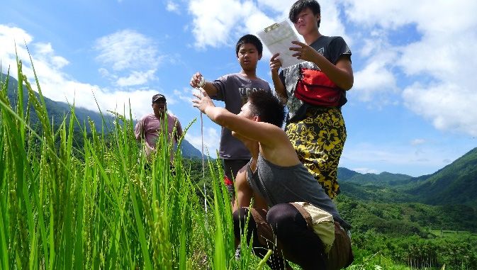
Geosciences 2021, 11, 310                                                                                            3 of 24

                            concepts (i.e., cultural landscape, socio-ecological production landscape of the Satoyama
                            Initiative, IUCN Category V Protected Landscape, and geopark) have led to the under-
                            standing and appreciation of Fengnan geodiversity by multiple actors involved in the area.
                                  The study poses the following research questions:
                            1.   How can the “know–cherish–show” community-based landscape tourism and in-
                                 terpretation model help to elicit the place of geodiversity and geotourism in their
                                 relation to other landscape resources?
                            2.   What are the lessons learned from the long-term institutional arrangement between
                                 primary and secondary stakeholders for the integrated landscape management in
                                 Fengnan Village?
                            3.   What is the role of the bridging stakeholder (NDHU) and of various landscape
                                 concepts applied as engagement techniques over the years?
                                 In the following section, we provide a description of the case study area and outline
                            the terms, concepts, and methods used in the study (Section 2). Then, we present the phase-
                            based results of our long-term engagement in Fengnan Village (2006–2011, 2011–2018, and
                            2018–2021) through the prism of the “know–cherish–show” community-based landscape
                            tourism and interpretation model (Section 3) and discuss the results in relation to the
                            research questions and existing research gaps (Section 4). In Section 5, we conclude with
                            the lessons learned, remaining challenges, and suggestions for future study.
                                 We note that our field of expertise is landscape conservation and community par-
                            ticipation with a particular emphasis on multi-stakeholder collaboration and capacity-
                            building. This explains why we placed our focus on cooperation between primary and
                            secondary stakeholders in the area rather than on tourists and recipient-related outcomes
                            of geotourism activities. To stay within the thematic scope of this article and provide a
                            retrospective analysis of our efforts, we omitted the results and discussion of other objec-
                            tives targeted by the integrated landscape management activities over the years. Detailed
                            contents and outcomes of each phase are presented in our published articles (in English
                            and Chinese) that are referenced where applicable throughout the text of this manuscript.

                            2. Materials and Methods
                            2.1. Description of the Case Study Area: Fengnan Village, Hualien County, Taiwan
                                 Taiwan Island is located on the western edge of the Pacific Rim of Fire within the
                            subduction zone and the junction of the Philippine Sea Plate and the Eurasian Plate [26],
                            while the case study area is situated in one of the most tectonically active, eastern, parts of
                            the country, the southern Coastal Mountain Range, Hualien County.
                                 Fengnan Village covers an area of 3500 hectares, occupies the upper and middle
                            reaches of the Turtle River watershed (northern part of the Taiyuan Basin) and spreads
                            across the Coastal Mountain Range and the Longitudinal Valley (Figure 1a). In addition
                            to possessing one of the highest uplifting rates in the world and a high frequency of
                            earthquakes [27], the area is also subject to rapid surface erosion processes caused by
                            seasonal heavy rainfalls and tropical cyclones (typhoons) [28].
                                 Due to their unique geological and geomorphological features, the Turtle River wa-
                            tershed, the Taiyuan Basin, and the Coastal Mountain Range all have been the subject
                            of rigorous research by domestic and foreign scholars for nearly half a century [29]. For
                            instance, numerous studies have focused on a thick volcaniclastic and siliciclastic sequence
                            that preserves the depositional records of the Luzon forearc that is well exposed in the
                            Taiyuan Basin [30]. With relatively little destruction by land-use activities, this area is
                            regarded as the key to unveiling the evolution of Taiwan’s arc-continent collision ter-
                            rane [29,31,32]. History of the Turtle River terraces [33], monitoring of the active Chihshang
                            fault [34], rich and diverse fluvial geomorphological features (such as gorge, high-altitude
                            gentle undulating surfaces, and unstable watershed divides) [35] have also been the subject
                            of extensive studies and geo-education activities over the years.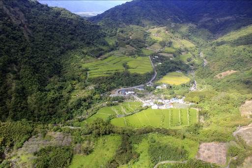
Geosciences 2021, 11, 310                                                                                                                4 of 24
  Geosciences 2021, 11, x FOR PEER REVIEW                                                                                                 4 of 24

                                   (a)                                                                      (b)

                                   (c)                                                                      (d)

                                   (e)                                                                      (f)
       Figure
     Figure 1. 1. FengnanVillage
               Fengnan     Village
                                 asas a coupled
                                    a coupled    socio–cultural–biophysicalsystem:
                                               socio–cultural–biophysical     system:(a)(a)location
                                                                                             locationofofcase
                                                                                                           casestudy
                                                                                                                 studyarea;
                                                                                                                        area;(b)(b) upstream
                                                                                                                                  upstream
       area of the Turtle River valley; (c) Cihalaay Cultural Landscape; (d) Small Tianxiang Gorge and the main settlement of
     area of the Turtle River valley; (c) Cihalaay Cultural Landscape; (d) Small Tianxiang Gorge and the main settlement of
       Cilamitay Tribe along the middle reaches of the Turtle River terraces, meanders, and alluvial plains (source of b, c, d
     Cilamitay Tribe along the middle reaches of the Turtle River terraces, meanders, and alluvial plains (source of b, c, d
       photos: Hualien Branch, Soil and Water Conservation Bureau, Council of Agriculture); (e) weekend community-based
     photos:  Hualien education
       environmental   Branch, Soil and Water
                                  courses       Conservation
                                          for Cilamitay       Bureau,
                                                        Indigenous    Council
                                                                    youth;       of Agriculture); (e)
                                                                            (f) community-based           weekendtourism
                                                                                                       landscape      community-based
                                                                                                                              activities.
     environmental education courses for Cilamitay Indigenous youth; (f) community-based landscape tourism activities.
                                          Due to their unique geological and geomorphological features, the Turtle River wa-
                                         The Turtle River catchment is primarily composed of mountains, shallow hills, river
                                     tershed, the Taiyuan Basin, and the Coastal Mountain Range all have been the subject of
                                   terraces, and river alluvial plains (Figure 1b–d). The natural integrity of mountainous areas
                                     rigorous research by domestic and foreign scholars for nearly half a century [29]. For in-
                                   above 500 m is well preserved with the forests and streams protected and managed by
                                     stance, numerous studies have focused on a thick volcaniclastic and siliciclastic sequence
                                   the Forestry Bureau, Council of Agriculture. The highest peak of the Coastal Mountain
                                     that preserves the depositional records of the Luzon forearc that is well exposed in the
                                   Range—Malaolou—is located at 1682 m on the eastern edge of the Fengnan area. Farming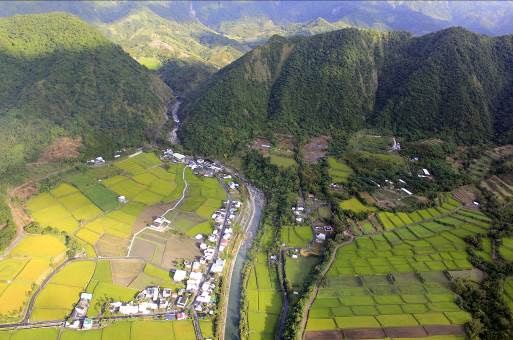
Geosciences 2021, 11, 310                                                                                                         5 of 24

                                 and gathering activities of the locals take place within shallow hilly areas below 500 m,
                                 while the settlements and paddy fields are situated along the river terraces and river
                                 alluvial plains (Figure 1d) [36].
                                       Fengnan Village is comprised of 288 households with a registered population of
                                 663 residents, 63% of which are Indigenous Amis [37], well-known for their traditional
                                 hunting, farming, and gathering skills as well as their knowledge of wild plants. The
                                 Cihalaay Tribe (1000 hectares) is a distinctive socio-ecological production landscape (SEPL)
                                 with close interactions between the local people, their land-use practices, and natural
                                 surroundings (Figure 1c). The Cihalaay community is largely dependent on local landscape
                                 resources for its sustainable livelihoods as even its name derives from “Hala”—an endemic
                                 protected fish species discovered in the stream by Cihalaay ancestors [38].
                                       Location of rice terraces atop the sloping hills is a characteristic feature of Cihalaay
                                 SEPL as most paddy fields in eastern Taiwan are spread across alluvial plains or river
                                 terraces. Stone walling structures of some terraced fields have remained intact over the
                                 years and serve as a living testament to the traditional building skills of the early settlers and
                                 as a link between local livelihoods and geodiversity. Both socio-cultural and biophysical
                                 attributes of the Fengnan area explain the need for its conservation and promotion as a
                                 unique living cultural landscape.

                                 2.2. Definition of Terms and Concepts
                                             Within the scope of our study, we defined landscape as a socio–cultural–biophysical
                                        system situated within defined geographic boundaries and comprised of human and
                                        non-human interactions within its geo, bio, and socio dimensions [21,22,39]. Based on M.B.
                                        Usher’s (2001) [40] “geosphere”, “biosphere”, and “anthroposphere” and D. O’Hare’s
                                        (1997) [41] nature–culture connectivity within a cultural landscape, we conceptualized the
                                        socio–cultural–biophysical system of a living landscape (Figure 2). There, geodiversity
                                        (G) acts as a “biophysical stage” or an abiotic background that hosts biotic elements: non-
                                        human (biodiversity, B) and human—local community with its cultural, social, and eco-
                                        nomic diversities (SCE). The spheres are shifted to the bottom to reflect the community-
                                        based bottom-up vision, which also coincides with the initial level of the community’s
                                        relative proximity to and familiarity with them: from the closest and most6 understood
     Geosciences 2021, 11, x FOR PEER REVIEW                                                                            of 24
                                        (SCE), relatively understood (B) to the farthest and least understood (G).

                                 Figure  2. Community-based
                                  Figure 2.                    landscape
                                            Community-based landscape      tourism
                                                                         tourism   within
                                                                                 within    a coupled
                                                                                        a coupled    socio–cultural–biophysical
                                                                                                  socio–cultural–biophysical sys- system.
                                  tem. IPLCs: Indigenous peoples and local communities.
                                 IPLCs: Indigenous peoples and local communities.

                                        We used the term community-based landscape tourism to refer to all types of tourism
                                  present in the landscape, which are planned and managed by and for the livelihood bene-
                                  fits (social, economic, and environmental) of the local community [24,25,41]. Community-
                                  based landscape tourism may be viewed as a sum of cultural/rural tourism, ecotourism,
                                  and geotourism directed at understanding, appreciating, and interpreting all of (or a com-
                                  bination of some) the biophysical and socio-cultural elements present in the landscape.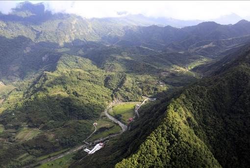
Geosciences 2021, 11, 310                                                                                           6 of 24

                                 We used the term community-based landscape tourism to refer to all types of tourism
                            present in the landscape, which are planned and managed by and for the livelihood benefits
                            (social, economic, and environmental) of the local community [24,25,41]. Community-
                            based landscape tourism may be viewed as a sum of cultural/rural tourism, ecotourism,
                            and geotourism directed at understanding, appreciating, and interpreting all of (or a com-
                            bination of some) the biophysical and socio-cultural elements present in the landscape.
                            Carried out from the community-based perspective, ecotourism and geotourism, despite
                            their biophysical foci as subtypes of nature tourism (Figure 2), also encompass a distinc-
                            tive socio-cultural and economic dimension and are inextricably linked to cultural/rural
                            tourism [42,43].
                                 Throughout 2006–2021, our team employed several landscape concepts as engagement
                            techniques in Fengnan Village, which included cultural landscape, socio-ecological production
                            landscapes and seascapes (SEPLS) of the Satoyama Initiative, IUCN Category V Protected Land-
                            scape, and geopark. Here, we briefly outline the meaning of each concept in its application
                            to the case study area.
                                 Prolonged and “intimate relationship between people and their natural environ-
                            ment” [44] is central to the understanding of cultural landscapes [8,40,45]. In Taiwan, the
                            cultural landscape concept received its legal recognition in the 2005 amendment of the Cul-
                            tural Heritage Preservation Act (CHPA) as “the location or environment which is related
                            to any myths, legends, record of events, historical events, social life or ceremonies” [46].
                            Official promulgation of cultural landscapes as the instrument for the conservation of living
                            landscapes in Taiwan was central to its application for the “Fengnan Aspiring Cultural
                            Landscape” Phase I (2006–2011).
                                 SEPLS are “dynamic biocultural mosaics of habitats and land and sea uses where the
                            interaction between people and the landscape (seascape) maintains or enhances biodiversity
                            while providing humans with the goods and services needed for their well-being” [47].
                            Since 2010, they have been promoted by the Satoyama Initiative as the landscape–seascape-
                            sized coupled human–nature systems with an emphasis on biodiversity conservation by
                            the means of sustainable production activities [48]. The concept of SEPL (no seascape in
                            the Fengnan case) and IUCN Category V Protected Landscape (as the one closest to SEPLS
                            and the Satoyama Initiative) were helpful during “Cihalaay Cultural Landscape” Phase II
                            (2011–2018).
                                 The term geopark was added as an amendment to Chapter 6, Article 78 of Taiwan’s
                            CHPA in July 2016 [46] though its clear legal definition is still lacking to date. In the
                            Fengnan context, we built upon UNESCO’s interpretation of the term [49] and applied this
                            long-awaited legal instrument as a landscape concept for “Turtle River Aspiring Geopark”
                            Phase III (2018–2021, ongoing).

                            2.3. Research Methodology
                                 This study is a long-term participatory action research carried out in Fengnan Village,
                            Hualien County, Taiwan from July 2006 to December 2021 (ongoing). Action research is
                            a qualitative method that implies a reflective linkage between the on-the-ground action
                            and the academic study of the researched phenomenon [50]. This method provided for our
                            dual role in the Fengnan area—as both facilitators (bridging stakeholder) and researchers.
                                 Several action research frameworks have been operationalized over the years, of which
                            the most substantial for the scope of this article are the “know–cherish–show” community-
                            based landscape interpretation model revised from F. Tilden’s (1957) theory of heritage
                            interpretation [51] and institutional capacity analysis based on P. Healey’s (1998, 2002) [52]
                            theory of collaborative planning.
                                 The “know–cherish–show” model implies understanding of local landscape resources
                            by the local community, appreciation of their value to the community, and the ability of
                            the local community to interpret these resources and their values to the visitors. Our revi-
                            sion of Tilden’s (1957) original phrase—“through interpretation, understanding; through
                            understanding, appreciation; through appreciation protection” [51]—shifts away from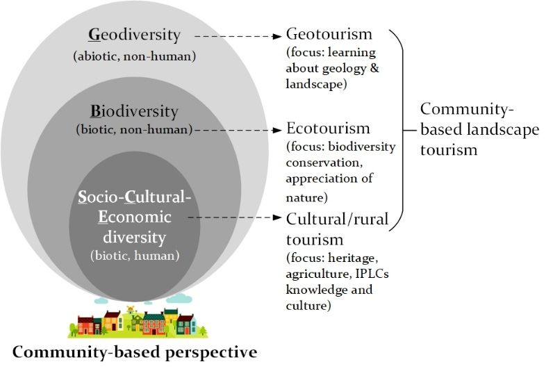
Geosciences 2021, 11, 310                                                                                             7 of 24

                            the recipient focus of environmental interpretation and distinctly places the emphasis
                            on a community-based perspective. The model has been consistently used for the im-
                            plementation and analysis of capacity-building activities throughout all three phases of
                            the study.
                                 P. Healey’s (1998, 2002) theory of collaborative planning served as a basis for evaluat-
                            ing the existing and developing a new institutional capacity among primary and secondary
                            stakeholders. Social capital (relational resources), intellectual capital (knowledge resources),
                            and political capital (mobilization capacity) [53] are the three criteria adopted for enhancing
                            participatory planning and management of community-based geotourism and geoconser-
                            vation over time.
                                 We employed the qualitative multiple-method approach to data collection and analysis
                            throughout all three phases of integrated landscape management in Fengnan Village in
                            the periods 2006–2011, 2011–2018, and 2018–2021. The qualitative method was the most
                            suitable for providing an in-depth insight into “inner experiences”, “language”, “cultural
                            meanings”, and “forms of social interaction” among stakeholders [54,55]. Multiple methods
                            consisted of desktop data analysis, field surveys, participant observation, individual
                            interviews, workshops, and group discussions [56,57]. These were combined in various
                            ways to better achieve on-the-ground and intellectual objectives of every phase of the
                            action research. Several triangulation strategies were also used to minimize the risk of
                            validity threats [50,58].
                                 To maintain a retrospective focus of this longitudinal study, we provide a concise
                            summary of each phase in Table 1, which outlines the relevant sub-phases, landscape
                            concepts applied, brief contents, stakeholders involved, “know–cherish–show” model with
                            a particular emphasis on the appreciation of geodiversity (G) and related outcomes. A
                            detailed information on multiple methods and materials of each phase may be found in the
                            relevant publications also listed in Table 1 and in the description of activities in Section 3.
Geosciences 2021, 11, 310 8 of 24
Table 1. Three phases of integrated landscape management for community-based landscape tourism in Fengnan Village, Hualien County, Taiwan (2006–2021).
Phase II: 2011–2018 Cihalaay Cultural Phase III: 2018–2021 Turtle River
Phases Phase I: 2006–2011 Fengnan Aspiring Cultural Landscape
Landscape Aspiring Geopark
Participatory planning, designation,
Participatory planning of University-community management and monitoring of Cihalaay Participatory planning of
Sub-phases partnership for Cultural Landscape
community-based landscape community-based geotourism and
tourism and place-based capacity-building of (2011–2018) geo-interpretation activities for rural
education for enhancing the interpretation skills for Weekend community-based community development within the
cultural landscape awareness community-based landscape environmental education courses for Turtle River Aspiring Geopark
(2006–2008) tourism Cilamitay Indigenous youth (2018–2021)
(2009–2011) (2012–2016)
+ Geopark
+ SEPL, the Satoyama Initiative
SEPL, the Satoyama Initiative
Landscape concept applied Cultural landscape + IUCN Category V Protected Landscape
IUCN Category V Protected Landscape
Cultural landscape
Cultural landscape
Landscape resources inventory (field
surveys, interviews, PPGIS 2 ),
Exploring Fengnan geopark potential:
collaborative planning, official
landscape resources inventory (field
Exploring Fengnan cultural landscape potential: landscape designation, management and
surveys, workshops, ecosystem services
resources inventory (interviews, field surveys, workshops), monitoring of Cihalaay Cultural
analysis), capacity-building of
Brief contents capacity-building (by NDHU 1 ) of landscape interpretation skills Landscape; conservation and sustainable
geo-interpretation skills (by NGOs and
of the local people, teachers and students, development of a use of Cihalaay SEPL 3 ; enhancing
academia), collaborative planning of
place-based curriculum place-based education, community-based
three core geodiversity areas, geotourism
(from the elders to the youth)
operations by multi-stakeholder platform
capacity-building of landscape
interpretation skills
Cihalaay Cultural Landscape
Fengnan Community Development Association; Yongfeng Ten 4 local organizations from
Primary Management Committee; Fengnan
Primary School Fengnan Village
Community Development Association
Stakeholders involved Bridging NDHU NDHU NDHU
HFDOFB;
HFDOFB 5 ;
Hualien Cultural Affairs Bureau; Ninth River Management Office 7 ;
Secondary Ministry of Education; Council for Cultural Affairs (former
HFDOFB other NGOs (incl. Geoparks Association
Ministry of Culture) 6
of Taiwan)Geosciences 2021, 11, 310 9 of 24
Table 1. Cont.
Phase II: 2011–2018 Cihalaay Cultural Phase III: 2018–2021 Turtle River
Phases Phase I: 2006–2011 Fengnan Aspiring Cultural Landscape
Landscape Aspiring Geopark
How? PPGIS, interviews, field surveys, Field surveys, workshops, ecosystem
Interviews, field surveys, workshops
Resources inventory tool workshops services analysis
“Know”: understanding SCE: Provisioning and cultural services
SCE + B: Cultural, ecological and
of landscape resources SCE 8 : Cultural, production; B: Provisioning, regulating and cultural
What? production values
B: Ecological; services
Landscape resources SCE, G: Historical, representative and
G: Scenic G + SCE: Regulating, provisioning and
rarity values
cultural services
G: Scenic resource, landscape
“Cherish”: appreciation G: Scenic resource, landscape background; regulating, provisioning and
G?
of geodiversity among G: Scenic resource background, source of drinking and cultural services with connectivity to
Local perception of G
other landscape resources irrigation water, and building material local livelihoods, local history and sense
of place
Cilamitay elders and youth:
Local-expert knowledge for Fengnan
capacity-building of landscape
Community-(school)-university partnership: capacity-building of geotourism development:
How? interpretation skills of the local
landscape interpretation skills (scenic emphasis) of the local capacity-building of geo-interpretation
Capacity-building Indigenous youth; interpretation of
people, teachers and students skills of the local people with the help of
“Show”: interpretation of SEPL’s cultural, ecological, and
relevant experts (NGOs and academia)
landscape resources production values
Community-based cultural/rural (tribal, Community-based landscape tourism
What?
heritage and agricultural) tourism, with elements of cultural/rural (tribal,
Aspect of landscape Community-based cultural/rural (tribal) tourism, ecotourism
ecotourism, heritage and agricultural) tourism,
tourism
green products ecotourism and geotourismGeosciences 2021, 11, 310 10 of 24
Table 1. Cont.
Phase II: 2011–2018 Cihalaay Cultural Phase III: 2018–2021 Turtle River
Phases Phase I: 2006–2011 Fengnan Aspiring Cultural Landscape
Landscape Aspiring Geopark
Enhanced community-based Further enhanced community-based
understanding, appreciation and understanding, appreciation and
Initial community-based understanding, appreciation and interpretation skills in relation to interpretation skills in relation to
Landscape resources development of interpretation skills in relation to scenic value of Cihalaay landscape resources with an landscape resources of the whole
Fengnan landscape resources and the connectivity between them emphasis on cultural, ecological and Fengnan Village with an emphasis on
production values of SEPL as well as its geodiversity value and its connectivity to
Outcomes conservation and sustainable use socio-cultural-economic diversity
“Multi-stakeholder” institutional
“Local-governmental” institutional
capacity: establishment of the
capacity: official collaboration with
multi-stakeholder platform between 10
Institutional capacity “Local-local” institutional capacity: community and school government agencies on protection of
primary and 15 secondary stakeholders
landscape resources in the name of
for collaborative governance of the Turtle
Cihalaay Cultural Landscape (est. 2012)
River Aspiring Geopark
Spatial scale (ha) Fengnan Village (3500 ha) Cihalaay Tribe (1000 ha) Fengnan Village (3500 ha)
Relevant publications [36] [38,59–64] [29,65–67]
Notes: 1 National Dong Hwa University (NDHU); 2 Public participation geographic information system (PPGIS); 3 Socio-ecological production landscape (SEPL); 4 Ten local organizations: Cilamitay Tribal Chief
Committee, Fengnan Village Office, Fengnan Community Development Association, Cilamitay Tribal Meeting, Cilamitay Tribal Cultural Association, Fengnan Neighborhood Watch Team, Fengnan Drinking
Water Committee, Fengnan Country Estate Homestay, Yongfeng Primary School, and Manna Rural Living Experimental Hub; 5 Hualien Forest District Office of the Forestry Bureau, Council of Agriculture,
Executive Yuan (HFDOFB); 6 Limited involvement; 7 Ninth River Management Office, Water Resources Agency, Council of Economic Affairs, Executive Yuan; 8 SCE—socio-cultural and economic diversity,
B—biodiversity, G—geodiversity (Figure 2).Geosciences 2021, 11, 310 3. Results 11 of 24
In this section, we describe the three phases of integrated landscape managem
community-based
3. Results landscape tourism activities in Fengnan Village: Fengnan A
Cultural
In thisLandscape (phase the
section, we describe I: 2006-2011),
three phases Cihalaay Cultural
of integrated landscape Landscape
management (phase I
2018), and Turtle River
and community-based Aspiring
landscape Geopark
tourism activities(phase III: Village:
in Fengnan 2018–2021,Fengnanongoing)
Aspiring(Table 1
In Figure
Cultural Landscape 3, (phase
we demonstrate these phases
I: 2006-2011), Cihalaay Culturalon a time scale
Landscape (phaseand in relation to t
II: 2011–2018),
and Turtle River Aspiring Geopark (phase III: 2018–2021, ongoing) (Table
of understanding (“know”), appreciation (“cherish”), and interpretation (“show” 1).
In Figure 3, we demonstrate these phases on a time scale and in relation to the level of
Fengnan landscape resources by the local community. It supplements Table 1 by pi
understanding (“know”), appreciation (“cherish”), and interpretation (“show”) of the Feng-
ing
nan the “know–cherish–show”
landscape resources by the localmodel
community.of community-based
It supplements Tablelandscape interpretati
1 by pinpointing
focal landscape resources
the “know–cherish–show” model and the connectivitylandscape
of community-based between them and The
interpretation. related
focal forms o
landscape resources and the connectivity between them and related forms
scape tourism are also indicated. In line with Figure 2 and Table 1, here, SCE (so of landscape
tourism are also indicated. In line with Figure 2 and Table 1, here, SCE (socio-cultural-
tural-economic diversity) stands for the biotic human component and cultural/rur
economic diversity) stands for the biotic human component and cultural/rural tourism,
ism, B (biodiversity)
B (biodiversity) for the
for the biotic biotic non-human
non-human component andcomponent
ecotourism, andandG ecotourism,
(geodiversity) and G
versity) for the
for the abiotic abiotic component
non-human non-human andcomponent
geotourism. and geotourism.
Figure 3.3.Three
Figure Threephases of integrated
phases landscape
of integrated management
landscape for community-based
management landscape tourism landsca
for community-based
in Fengnan
ism Village,Village,
in Fengnan 2006–2021.2006–2021.
3.1. Phase I: 2006–2011: Fengnan Aspiring Cultural Landscape
3.1. Phase I: 2006–2011:
Uniqueness Fengnan
of biophysical andAspiring Cultural
socio-cultural Landscapeof Fengnan Village
characteristics
(Section 2.1) as wellof
Uniqueness asbiophysical
the picturesqueandbeauty of its landscape
socio-cultural is what motivated
characteristics of Fengnanour Villa
initial interest in the area prior to 2006. It was essential though to find a suitable engage-
tion 2.1) as well as the picturesque beauty of its landscape is what motivated ou
ment technique to kindle the dialogue with the local people and bring attention to the
interest
richness ofintheir
thebiotic
area and
prior to 2006.
abiotic It was
landscape essential though to find a suitable enga
resources.
technique
Despitetoourkindle
expert the dialogue
interest with the local
in the geodiversity of thepeople andasbring
area as well attention
the scientific and to the r
educational value of Fengnan geomorphology
of their biotic and abiotic landscape resources. [31–33], we began our involvement not from
the geopark but from the cultural landscape concept. The main rationale for this choice was
Despite our expert interest in the geodiversity of the area as well as the scient
that geopark, as a legal instrument for conserving abiotic nature in Taiwan, had not been
educational value of Fengnan geomorphology [31–33], we began our involvem
from the geopark but from the cultural landscape concept. The main rationale
choice was that geopark, as a legal instrument for conserving abiotic nature in T
had not been promulgated until ten years later as a 2016 amendment to CHPA. AGeosciences 2021, 11, 310 12 of 24
promulgated until ten years later as a 2016 amendment to CHPA. Another explanation
was a relative “remoteness” and a lesser level of understanding of geodiversity (G) by the
local community compared to their abundant knowledge about socio-cultural (SCE) and
ecological (B) resources of the area (Figure 2).
Aware of our role as a bridging stakeholder who was new to the area, we realized that
the introduction of any landscape concept had to follow the pace of the local people and
respect their boundaries by allowing them a sufficient time for understanding, appreciating,
and being able to interpret their landscape resources. For this reason, during phase I
(2006–2011), we did not intend to designate a cultural landscape, but rather to explore a
potential for its designation in the future (Table 1). Relevant activities of the phase may be
divided into two sub-phases: (2006–2008) collaborative landscape resource inventory by the
means of field surveys, workshops, and interviews as a basis for future community-based
landscape tourism activities and place-based education; and (2009–2011) community–
school–university partnership for the capacity-building of landscape interpretation skills
of the local people, students, and teachers [36].
The landscape resources inventory revealed four categories of resources: cultural
(the building of Yongfeng Primary School, Cilamitay Community Center, Earth God Tem-
ple, etc.) and production resources (e.g., organic rice, plums, and persimmons, wild-
harvested bamboo, Indigenous Amis handicrafts, etc.) within the SCE component; eco-
logical resources (rattan trees and edible wild plants, faunal inhabitants of the Turtle
River watershed: endemic Hala fish, river crab, freshwater soft-shelled turtle, freshwater
shrimp, etc.)—component B; and scenic resources (terraced paddy fields, “Sleeping Beauty”
Mountain, Stone Gate Channel, waterfalls, Small Tianxiang Gorge, etc.)—component G [36].
Capacity-building of landscape interpretation skills focused on addressing the land-
scape resources most familiar to and well-understood by the local people—cultural, pro-
duction, and ecological. As skilled gatherers, hunters, and fishers, the Indigenous Amis
people of Fengnan Village could easily interpret their rich local culture in the context of
cultural/rural tourism and ecotourism. At the time, appreciation of geodiversity (G) by
the local people was limited to it being a “beautiful scenic resource” and an attracting
factor for the visitors. The scenic landscape sites were briefly mentioned as a part of early
cultural tourism and ecotourism activities, but no specially designed geo-interpretation
was provided at the time. This explains why in Figure 3 the culture (C) and biodiversity
(B) were the focal resources of the phase, while G remained in the background. In addi-
tion, connectivity between various landscape resources and their relevant inclusion into
community-based landscape tourism activities was not yet evident (Figure 3).
NDHU acted as a bridging stakeholder between the Fengnan Community Develop-
ment Association and Yongfeng Primary School (primary stakeholders) and Hualien Forest
District Office of the Forestry Bureau (HFDOFB) and Ministry of Education and Council
for Cultural Affairs (secondary stakeholders). Activities of the phase (community forestry
projects and place-based outdoor workshops) were financially supported by HFDOFB,
Ministry of Education and, to a limited extent, by the Council of Cultural Affairs.
Laying out a solid foundation for the “local–local” institutional capacity among pri-
mary stakeholders was one of the main outcomes of the phase. This may be attributed to a
pro-active role of NDHU in facilitating a community–school–university partnership for lo-
cal capacity-building [36]. In 2009–2011, due to the leadership changes at Yongfeng Primary
School, its principal pulled back from the triangular partnership arrangement, however,
NDHU continued to work with the local community on a bilateral basis. Community-based
interpretation workshops where NDHU students acted as planning partners and tourists
are an example of the continuous partnership with the locals.
3.2. Phase II: 2011–2018: Cihalaay Cultural Landscape
Assessment of the Fengnan cultural landscape potential during the initial five years of
our engagement in Fengnan Village allowed us to observe its distinctive nature–culture
characteristics [38,59,61]. By 2011, the local people also possessed a sufficient level ofGeosciences 2021, 11, 310 13 of 24
familiarity with the concept and knowledge of their landscape resources in order to take
the next step—designation of the Cihalaay Cultural Landscape. Worth noting though, as is
evident from Figure 1a, the Cihalaay Tribe is a smaller area (1000 ha) within the Fengnan
landscape (3500 ha). The reasons for choosing Cihalaay for cultural landscape designation
can be explained, on one hand, by a high degree of nature–culture representativeness of
its landscape elements and, on the other hand, by a relative simplicity of its stakeholder
composition compared to a larger Fengnan Village.
During Phase II, in addition to cultural landscape, we also introduced the concept
of SEPL and the Satoyama Initiative (Table 1) [47,60]. Its emphasis on conservation and
sustainable use of landscape resources for the benefit of biodiversity and human well-
being [47,48] brought a previously less accentuated element of eco-friendly production into
the spotlight. IUCN Category V Protected Landscapes management guidelines [68–70]
and the six-step ladder of community engagement [71] also served as a helpful guide in
the process.
Landscape resources inventory by the means of field surveys, interviews, and public
participation geographic information system (PPGIS) techniques was performed as part of
the issue identification stage [61] at the beginning of Phase II (2011). This was followed
by collaborative planning, official designation of the Cihalaay Cultural Landscape by
the Cultural Heritage Review Committee of Hualien Cultural Affairs Bureau (2012), and
community-based management and monitoring activities (2015) [62,63]. A 2012–2016 sub-
phase involved a series of weekend community-based environmental education courses
for Cilamitay Indigenous youth [62,64] that prioritized place-based education on the topics
closely related to Cilamitay landscape resources: agricultural production and livelihoods,
community and culture, landscape and nature conservation (Figure 1e). In addition, it was
the first time that landscape interpretation capacity-building training was taught by the
local Indigenous elders to the local Indigenous youngsters—a new type of local traditional
ecological knowledge (TEK) transmission [64].
Understanding of the landscape resources during this phase was intricately linked to
their value for the local community [38,60]. Ecological (B), economic, and cultural (SCE)
values of the Cihalaay Cultural Landscape highlight its role in conservation and sustainable
resource use. Connectivity between the SCE and B components is shown in Figure 3. It
elicits the importance of sustainable agricultural, hunting, fishing, and gathering activities
traditionally practiced by the Indigenous Amis Cihalaay community. SCE-B connectivity
also reflects a newly discovered emphasis on the eco-agricultural production value of
Cihalaay SEPL, promotion of cultural/rural tourism and ecotourism activities, and the
marketing of green products.
The historical, representative, and rarity values of Cihalaay SEPL are associated with
its SCE and G components (Figure 3). Unique irrigation channels (Stone Gate Channel)
and irregular-sized rice terraces cut out in steep mountain slopes [60] are examples of
long-term human and abiotic nature interactions in the area. Though not yet officially
developed into geo-interpretation activities during Phase II, these “living and fossil cultural
landscape” resources [60] were deeply appreciated by the local people. They served as a
scenic background for their community-based landscape interpretation activities—told as
a part of family history or as lyrics of a local Indigenous song [64]. Direct contribution of
geodiversity (G) to local livelihoods as a source of drinking and irrigation water and as a
building material was also clearly recognized at this stage.
Multiple stakeholders involved in Phase II included the Cihalaay Cultural Landscape
Management Committee and Fengnan Community Development Association (primary
stakeholders), Hualien Cultural Affairs Bureau, and HFDOFB (secondary stakeholders).
The bridging role of NDHU was aimed at allowing a new type of institutional capacity
(“local-governmental”) to emerge between the local people and the government agencies
through official collaboration on the protection of local landscape resources in the name of
the Cihalaay Cultural Landscape.Geosciences 2021, 11, 310 14 of 24
It is worth noting that in 2012, the same year that the Cihalaay Cultural Landscape
was officially designated, our team initiated a two-year project commissioned by the
Forestry Bureau titled “A study of national community-based geopark management and
planning framework in light of international experiences” [72]. The aim of the project was
to review international experiences (IUCN and UNESCO) in relation to the planning and
management of geoparks and applying them to assess the Turtle River Geopark potential
in Fengnan Village. During the first year of the project, the local community worked closely
with various environmental NGOs from Hualien County. Together, they conducted an
assessment of the Fengnan geodiversity resources and compiled a strong body of evidence
confirming a high geopark potential of the area. However, due to the lack of required legal
instruments (same reason as in 2006, Section 3.1), the project was discontinued after just
one year.
Nevertheless, despite its cessation, the 2012 project resulted in a rich geo-knowledge
database, stimulated community cohesion around the geodiversity topic, and promoted
the partnership between Fengnan residents and Hualien NGOs. The one-year efforts not
only enhanced the appreciation of geodiversity by the local community, but also paved
the way to reintroduction of the geopark concept in 2018 when the institutional climate
became favorable.
3.3. Phase III: 2018–2021: Turtle River Aspiring Geopark
In 2016, the geopark concept was officially added as an amendment to Chapter 6,
Article 78 of CHPA and became the long-awaited legal instrument to value and conserve
Taiwan’s abiotic nature [46]. It was finally time to reintroduce the idea of the Turtle River
Geopark to Fengnan Village and thoroughly explore its geopark potential. The actual
planning for geopark designation was not a goal of this—aspiring—stage, as it was to be
aligned with and determined by the future aspirations of the Fengnan community itself.
Phase III (2018–2021) was viewed by multiple stakeholders as an opportunity to
engage the whole of Fengnan Village as opposed to a smaller Cihalaay area during Phase II.
This time, expanding the spatial scale of the approach was motivated by at least two factors.
First, it was a response to the opposition voices coming from some Fengnan residents that
“too much attention was paid to small Cihalaay Tribe.” Second, it meant consideration of a
changed stakeholder composition and leadership shifts in Fengnan Village, where several
newly emerged community organizations were eager to become involved.
Resource inventory as the key to the understanding of local landscape resources was
conducted by means of field surveys and workshops with a particular focus on geodiversity
(G) and its ecosystem services [65] (Table 1). Based on the inventory results and related
discussions, five, and later three, core geodiversity areas were identified as potential
geo-interpretation sites of the Turtle River Aspiring Geopark [29].
Ecosystem services analysis revealed that geodiversity component (G) was no longer
perceived as merely a scenic resource or a landscape background, but was viewed as a
source of vital services for community livelihoods [65]. For example, provisioning services
were observed in the relationship between local water sources and geological composition
and structure, between building materials used for terraced ridges or traditional houses and
nearby rocks and soil, and between traditional irrigation channels and mudstone clay layers.
Analysis of regulating services elicited connectivity between the surface- and groundwater
system and regional folding and faulting structures and between fish habitats of streams,
pools, and ripples and soft-hard rock interbedded structures. Cultural ecosystem services
revealed the strongest linkage to local livelihoods and TEK with geodiversity reflected in
local toponyms, Indigenous Amis folklore, hunting, fishing, and gathering practices, and
in a sense of place and local pride (e.g., the Turtle River and the Small Tianxiang Gorge
were seen as representative symbols of the area) [29,67].
Deepened understanding and appreciation of geodiversity (G) and its relationship
to local livelihoods, history, and culture (SCE + G in Figure 3) further incited the Fengnan
community’s interest in geo-interpretation. At that time, community-based landscapeGeosciences 2021, 11, 310 15 of 24
tourism in Fengnan Village was ready to fully encompass its abiotic boundaries and work
toward the development of geotourism activities. Capacity-building for community-based
geotourism, however, differed from capacity-building activities of the previous two phases.
Due to an inherent complexity and a lesser familiarity of the local people with geo-terms
(geodiversity, geology, geomorphology, geoconservation, geotourism, etc.), a substantial
input from the expert knowledge was required [66].
To address this need, our team facilitated a series of geo-interpretation training work-
shops that included field expeditions and interactive lectures by an invited geology special-
ist [29,31]. This type of capacity-building exercise, on one hand, communicated a scientific
vision of the unique geomorphological and geodiversity value of the area [62] and, on
the other hand, highlighted an intrinsic interconnectedness between geodiversity (G) and
other components (SCE and B) of the Fengnan landscape. Geodiversity was explained
as a large “biophysical stage” (Figure 2) that accommodates the geological, topographic,
hydrological, ecological, land-use, and socio-cultural features of the area.
Thus, with the help of experts, Fengnan locals were offered an opportunity to see the
abiotic component of their familiar landscape in a new light. By further weaving their own
TEK with expert knowledge, they began to gradually develop a new landscape (geo-) inter-
pretation capacity and practice it via self-organized community-based geotourism activities
throughout 2020 and 2021 (Figure 1f). In early 2021, the first geo-interpretation guidebook
for the Turtle River Aspiring Geopark “Searching for roots in the mountain valley” [73]
was published by the Fengnan community with assistance from NDHU and HFDOFB.
At this stage, along with geotourism and geo-interpretation development, the Fengnan
community also began examining potential geo-products for promoting the aspiring geop-
ark and generating additional income for the local people. Grown in an eco-friendly way
on the sloping hills, and nurtured by a network of traditional irrigation channels adhering
to local geological composition and structure, Hala rice paddies provide a habitat to the en-
demic protected Hala fish and are an indispensable part of Indigenous Amis traditions and
culture. These features make Hala rice not only a frontrunner among potential geo-product
options, but also a symbol of the Fengnan socio–cultural–biophysical landscape.
Establishment of a multi-stakeholder platform for collaborative governance of the
Turtle River Aspiring Geopark is central to the institutional capacity outcomes of the cur-
rent phase. Set up in 2020, the platform comprises ten local organizations from Fengnan
Village as primary stakeholders (Cilamitay Tribal Chief Committee, Fengnan Village Office,
Fengnan Community Development Association, Cilamitay Tribal Meeting, Cilamitay Tribal
Cultural Association, Fengnan Neighborhood Watch Team, Fengnan Drinking Water Com-
mittee, Fengnan Country Estate Homestay, Yongfeng Primary School, and Manna Rural
Living Experimental Hub) and 15 secondary stakeholders including HFDOFB, the Ninth
River Management Office, and several NGOs (Geoparks Association of Taiwan, among
them). The multi-stakeholder platform collaboratively plans, manages, monitors, and
adjusts geotourism activities in the area, while its efforts have already led to the inclusion
of the Turtle River Aspiring Geopark in the Taiwan Geoparks Network (2020) [74].
4. Discussion
In this section, we share the takeaway messages from our 15 years of experience
with integrated landscape management in Fengnan Village based on the three research
questions and addressing the existing research gaps (Section 1). Landscape resources
of the Fengnan socio–cultural–biophysical system (SCE, B, and G) and the institutional
arrangement between primary, secondary, and bridging stakeholders are conceptualized
in Figure 4.Geosciences 2021,
Geosciences 11, x310
2021, 11, FOR PEER REVIEW 1616ofof24
24
Figure 4. Landscape resources and institutional arrangement for integrated landscape management
Figure 4. Landscape resources and institutional arrangement for integrated landscape management
within aasocio–cultural–biophysical
within socio–cultural–biophysical system.
system.
4.1. “Know–Cherish–Show–Cherish Even More” of the Landscape Resources
4.1. “Know–Cherish–Show–Cherish Even More” of the Landscape Resources
With its different variations, the “know–cherish–show” community-based landscape
With its different
interpretation model variations,
has been appliedthe “know–cherish–show”
through all three phases community-based
of integrated landscape
landscape
interpretation model has been applied through
management in Fengnan Village (Table 1). “Know” implied taking all three phases of integrated
stock oflandscape
the land-
management
scape resources in Fengnan
(SCE, B, Village
and G) (Table 1). “Know”ofimplied
at the beginning each phase takingbystock of the landscape
the means of various
resources (SCE, B, and
community-based G) at the beginning
data-collection techniques of each
(fieldphase
surveys, by the means of
interviews, various commu-
workshops, PPGIS,
nity-based data-collection techniques (field surveys, interviews,
and ecosystem services analysis). “Cherish” stood for the local people’s appreciation workshops, PPGIS, andof
ecosystem services analysis). “Cherish” stood for the local people’s
the landscape resources (with an emphasis on G). “Show” entailed a series of community- appreciation of the
landscape resources
based landscape (with an emphasis
interpretation and relevant on capacity-building
G). “Show” entailed a series
activities for of
thecommunity-
local people
based landscape
and stemmed interpretation
from their level ofand relevant capacity-building
understanding and appreciationactivities for the local
of the landscape peo-
resources
ple
at aand stemmed
given point infrom
time. their level of understanding and appreciation of the landscape
resources
As anatupward
a given arrow
point in in time.
both Figure 3 (on a temporal scale) and Figure 4 (on a spatial
As“cherish”
scale), an upward is aarrow
centralin component
both Figureof3 the (on model.
a temporal scale) andofFigure
Appreciation 4 (onresources
landscape a spatial
scale), “cherish”
for their valuesisora central
for the component
ecosystem of the model.
services theyAppreciation
provide [6,7,9] of landscape
is a driving resources
engine
for their values
(motivation, or for the ecosystem
inspiration) services they
for community-based provide [6,7,9]
landscape tourism is aactivities.
driving engine
The level(mo- of
tivation, inspiration)
appreciation maturesfor community-based
over time, along withlandscape
a gradualtourism activities.
accumulation The
of the level
local of ap-
people’s
landscape matures
preciation knowledge overand theiralong
time, enhanced
with asense of place,
gradual belonging,ofand
accumulation thepride
local [4,8]. Fur-
people’s
thermore, knowledge
landscape “cherish” transcends the boundaries
and their enhanced senseof ofappreciation—from
place, belonging, and separate landscape
pride [4,8]. Fur-
components
thermore, (C in SCE
“cherish” and B during
transcends Phase I) of
the boundaries toappreciation—from
the connectivity and interdependence
separate landscape
between them (E in SCE + B during Phase II to G + SCE during
components (C in SCE and B during Phase I) to the connectivity and interdependence Phase III). To indicate this
“snowball” overlapping nature of the appreciation process, we may
between them (E in SCE + B during Phase II to G + SCE during Phase III). To indicate this also name the model
“know–cherish–show–cherish
“snowball” overlapping nature even more”
of the (Figure 4).process, we may also name the model
appreciation
Elaborating further on the
“know–cherish–show–cherish “cherish”
even component,
more” (Figure 4). it is imperative to understand what
it means for geoconservation
Elaborating further on theand the development
“cherish” component, of community-based
it is imperative to understand geotourism what in
the area. Our experience in Fengnan Village allowed us to
it means for geoconservation and the development of community-based geotourism inobserve that in a living nature–
culture
the area.landscape
Our experiencewith aindistinctive geodiversity
Fengnan Village allowedvalue, appreciation
us to observe that in ofageodiversity
living nature– isYou can also read