Galileo Search and Rescue Service at work over a powered paraglider flight
←
→
Page content transcription
If your browser does not render page correctly, please read the page content below
Galileo Search and Rescue Service at work over a powered paraglider flight
                                        Xavier Maufroid, European Commission
                                    Yoan Grégoire, Centre National d’Etudes Spatiales

Abstract

In flight emergencies over water or over land, the
capability to communicate in a very simple way your
distress and position is essential if you want to get a
chance to be rescued quickly and sometimes avoid a
fatal issue.

This is typically the case of adventure travel with a
powered paraglider (paramotor) where distances of                       Figure 1: In-flight test of Galileo Search and Rescue
up to 200 kilometres can be flown in a single flight in
4-5 hours. During such flights, many incidents can              Introduction: The SAR Galileo Service
occur due to changing weather or material issue on
                                                                The Galileo Search and Rescue Service (SAR) has
your glider/engine bringing you in an emergency and
                                                                been operational since 2016 and has delivered since
where fast actions are needed to transmit your
                                                                then excellent performances in terms detection and
position in case things would turn wrong. This is even
                                                                localisation of signals transmitted by distress
truer if you travel in a place where communications
                                                                beacons. As a contribution to the Cospas-Sarsat
networks are inexistent. In these cases, the use of a
                                                                System, the Galileo SAR infrastructure includes 24 in-
406MHz satellite distress beacon such as a PLB
                                                                orbit transponders on-board the Galileo satellites
(Personal Location Beacon) which can be quickly
                                                                which relay the distress beacons to a set of three
activated by a simple “press button” could save your
                                                                Ground Stations connected to each other – called
life. The signal of such distress beacon can be
                                                                MEOLUTs – located in Maspalomas, Svalbard and
localized by the Galileo Search and Rescue System
                                                                Cyprus (Figure 2).
and transmitted to the relevant national Search and
Rescue centres.

Want to clear any doubt on whether this works
efficiently or whether Galileo is capable of localizing
you fast enough and with sufficient precision as a
moving target to enable the rescue? This is what a
team of people of the Galileo Programme with the
support of the French National Space Agency and the
Cospas-Sarsat French Mission Control Centre has                           Figure 2: The 4-antennas MEOLUT in Svalbard

tried to demonstrate through the test of the
                                                                The three Galileo EU MEOLUTs, which provide an
activation of a PLB during a paramotor flight in a
                                                                overall tracking capability of 12 satellites, can detect
controlled environment (Figure 1).
                                                                the distress signal, compute the location of the
                                                                beacon and send the corresponding information to
                                                                the Cospas-Sarsat Mission Control Centres.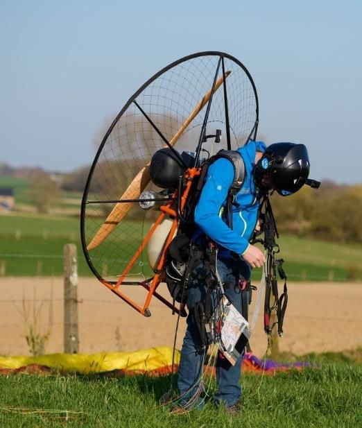
Galileo SAR Performances – Impact of moving beacon movement can impact the performances of
beacons the localization algorithms of the MEOLUTs. Testing
the performances of the Galileo SAR over a powered
In order to guarantee the complete independence of
paragliding flight can therefore turn to be also a
the Galileo SAR Service from the availability of GNSS useful mean to demonstrate how the system
signals, the position of the distress beacon is behaves with rather slow moving speeds (between
primarily based on the measurements of the time 20km/h and 40km/h), without suffering from the
difference and frequency difference of arrival (TDOA
blockage /masking that would result from a ground
and FDOA) of the distress signal relayed by several test. In addition, such a demonstration will be used
satellites in parallel. The associated performances to confirm the relevance of owning a Personal
reach typically performances between 1km to 5km, Location Beacon (PLB) when travelling abroad
which is suitable for SAR operational purposes. In paramotor flight.
some cases, a GNSS position can also be computed
by the beacon (if a GNSS receiver is embedded and
depending on the time to first fix and beacon switch-
on time), this position can be encoded in the distress
signal message to provide more accurate
information (typically in the order of 100m
considering the truncation of the message). As a
result, the performances of the Galileo SAR Service
are defined only based on TDOA and FDOA Figure 3: SAR/Galileo Performances over fixed reference beacons
measurements (without any GNSS encoded
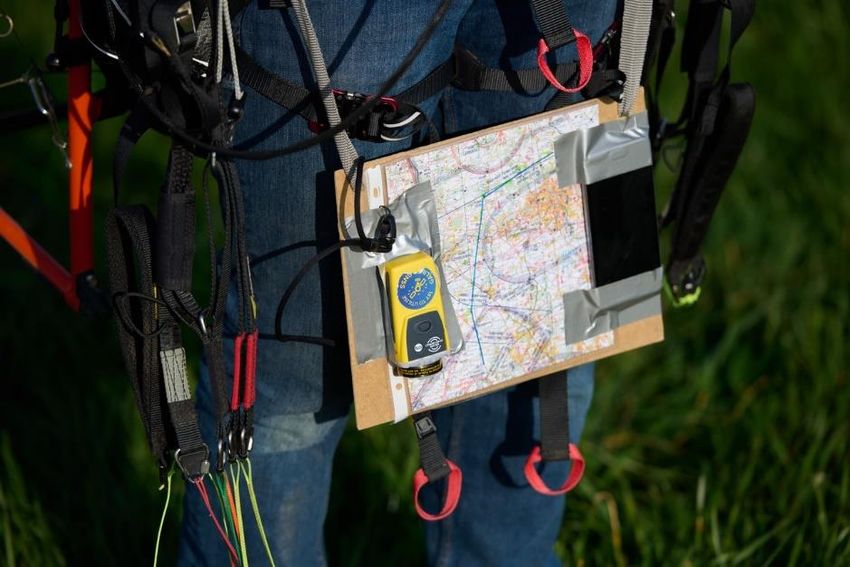
Flight Test set-up
location). These performances are reported on a
monthly basis and have shown to be excellent Personal Location Beacon (PLB), HEX Identifier:
(Figure 3) over the last year. 1C6E980002FFBFF;
The system performances are monitored Flight software on a smartphone: use of PPGPS
continuously with fixed, non-moving reference application providing a sampling of the flight with
beacons, and not many data are unfortunately one recorded GPS/Galileo position every two
communicated on the very good performances of seconds, storing all information on a KML
Galileo SAR Service achievable with moving beacons. (Keyhole Mark-up Language) file;
Indeed, in the majority of cases a fixed distress Paramotor Miniplane Top80.
beacon assumption is not really representative and
the additional Doppler effect resulting from the
Flight software
Distress Beacon
Figure 4: Test set-up with PLB Galileo Enabled and Flight Software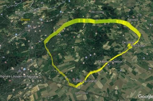
Test Execution and Technical Performances: - Single Burst Location Probability: 96.6% (56
localisations out of 58 bursts)
The test was executed on 31st of March 2021 in the - Single Burst Location Accuracy: 4.16km @70%
Control Zone of Beauvechain (Belgium), not active at and 8.56km @95%, which is line with the Cospas-
that time: Sarsat specification for slow-moving beacons at
- Take-Off Time: 16:16:26sec UTC, Position: medium speed (10km @70% and 20km @95%)
4.7448°E, 50.6917116°N, Longueville, Belgium - Multi-Burst Location Probability (@10min):
- Landing Time: 17:06:45sec UTC, Position: 2.71km @75% and 3.77km@ 95%
identical to Take-Off The performances are of course not as good as for
The flight path recorded by the Flight Software fixed beacons monitored on a monthly basis with the
PPGPS is shown on Figure 4. Galileo Reference Beacons but are more than
compliant with Cospas-Sarsat specifications for
The beacon was switched on at 16:20:15sec, in a moving assets and meet the operational needs of
position identical to Take-Off. A first location was Search and Rescue teams for localising quickly the
achieved by the European MEOLUT at 16:23:01sec distress location.
based on the first burst transmission of 16:21:01, i.e.
in less than 3 minutes and with a localization error Another important aspect is the capability of the
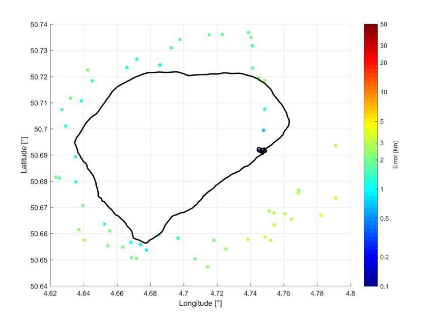
of 5.07km. This first position was obtained through a Galileo SAR Service to track the distress position over
combination of the 3 European MEOLUTs and a the overall flight. Figure 5 below depicts all the multi-
combination of 6 Galileo SAR Transponders (GSAT- burst locations that could be computed by the
0206, 0209, 0215, 0219, 0220 and 0221) and 3 GPS Galileo EU MEOLUT and compares them with the
DASS transponders (USA equivalent to SAR/Galileo). actual flight path, the colour code indicates the error
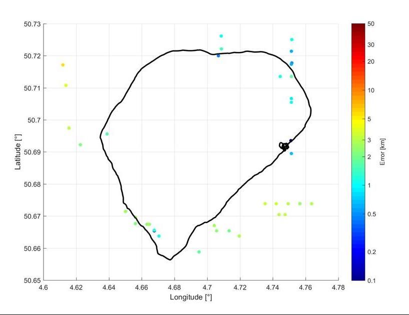
of the location with regard to the exact position on
the flight pass at the moment of the computation of
the position by the Galileo EU MEOLUT and as it can
be seen, all positions errors are well below 4km.
Figure 4: Recorded flight pass over 27km in Beauvechain CTR
During the 50-minutes flight, 58 bursts were
transmitted by the distress beacon following its
activation. The overall technical performances are
the following:
Figure 5: Successive Multi-burst locations vs. actual flight track
- Detection Probability: 100% (All the 58 signal
bursts transmitted by the distress beacon have CNES has developed in-house an experimental
been detected - 80% through more than 6 algorithm that implements a Kalman filter and which
satellites) enables to further optimize the tracking of the flight
based on the measurements made by the Galileo EU
MEOLUT, taking into account the estimated speed of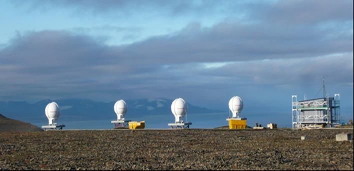
the beacon. This algorithm is not deployed in the                         beacons, as shown on Figure 6 where the successive
Galileo EU MEOLUT but has clearly a potential for                         computed position reflect quite well the flight pass.
improving the performances for tracking moving

         Figure 6: Computation of successive distress positions through CNES Kalman algorithm and Galileo EU MEOLUT Measurements

Operational Aspects                                                       only be confirmed an hour later by the test executor.
                                                                          This demonstrated once again that the Galileo SAR
Due to the lack of Test Distress beacon, the test was                     Service is not just a standalone technical capability
executed with an operational distress beacon                              but is integrated in a real operational chain aiming at
(beacon used in a previous event coordinated by the                       rescuing all citizens over Europe and beyond as soon
European Commission for the SharkBait                                     as possible.
demonstration). In order to avoid triggering the
complete Search and Rescue command chain with                             Conclusions
national SAR authorities, the HEX ID of the distress
beacon had been preventively communicated to the                          Want to clear any doubt on whether Galileo Search
FMCC. However, for some reasons, the HEX ID                               and Rescue works efficiently or whether Galileo is
indicated on the beacon (1C6E8CAE5CFFBFF) had                             capable of localizing you fast enough and with
been previously reprogrammed to another value                             sufficient precision as a moving target over a
(1C6E980002FFBFF) for the European Commission                             paramotor flight to enable the rescue? This test
“SharkBait” demonstration, such that an incorrect                         demonstrated the real benefit of owning a Cospas-
HEX ID was communicated to the FMCC unknowingly                           Sarsat 406MHz distress beacon when going through
and this alert could not be filtered out as a test                        adventurous destinations. Galileo SAR not only is
transmission.                                                             capable today to locate you extremely fast – in less
                                                                          than 3 minutes – and with a good operational
As a result, the overall command chain for Search                         precision – below 4km without any GNSS encoded
and Rescue was triggered following the information                        location – to allow Rescue Operations to intervene
disseminated by the Cospas-Sarsat French MCC to                           but also the Galileo SAR Service has the potential for
relevant RCCs in Belgium. In particular the ARCC of                       tracking your distress all along your journey with
Beauvechain, very close to the place where the alert                      unprecedented accuracy!
was located, reacted in a very efficient and
professional manner, tried to contact several times
the beacon owner to ascertain about the “validity”
of the alert and prepared actively the rescue
operations. The test nature of the transmission could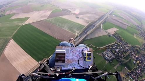
You can also read