Geology & Geophysics Honours Projects - Honours project topics and supervisors available for 2020 - The University of ...
←
→
Page content transcription
If your browser does not render page correctly, please read the page content below
Geology & Geophysics
Honours Projects
Honours project topics and supervisors
available for 2020

Faculty of Science, School of Geosciences

Geosciences: Geology & Geophysics Honours Projects 2020 (v.09-10-19)
Contents
1           Honours projects ...................................................................................................................................... 3
                       Earthquake fault mechanics in the Sydney Basin .................................................. 3
                       Kinematic evolution of the Redbank thrust zone, Central Australia................... 4
                       Mineralogical and chemical characterization of a suspected NSW meteorite
                       ........................................................................................................................................ 5
                       Formation of the mantle-crust transition zone in the New Caledonia forearc
                       ophiolite ........................................................................................................................ 6
                       Deformation processes in a mantle shear zone in the Pindos forearc ophiolite,
                       Greece (and a second, co-related project on earthquakes) .............................. 7
                       Gold in NSW ............................................................................................................... 8
                       New Perspectives on Archean Tectonics ................................................................. 9
2           Honours projects available through the Earthbyte group............................................................ 10
                       How climate and subsidence control the sedimentation along the Norwegian
                       Margin? ....................................................................................................................... 10
                       How is landscape complexity driving biodiversity over geological time
                       scales?.......................................................................................................................... 11
                       Oceanic upwelling and the distribution of deep-sea organic carbon since the
                       Cretaceous Period..................................................................................................... 12
                       Vertical motions of the Tasman and Coral Sea: possible link to Ontong Java
                       Plateau collision? ....................................................................................................... 14
                       How has subduction influenced the opening of the Drake Passage? .............. 15
                       The tectonic and surface process evolution of Papua New Guinea ................ 16
                       The role of mechanical stratigraphy in the structural style and development
                       of fold and thrust belts ............................................................................................. 17
                       Lithospheric mechanical layering and mountain building processes ................ 18
                       Effect of mechanical layering on lithospheric coupling in strike-slip fault
                       systems......................................................................................................................... 19
                       Multi-core parallel tempering for extending BayesReef for modelling reef
                       growth on geological timescales ............................................................................ 20
                       Understanding the link between plate tectonics and landscape-basin
                       evolution ...................................................................................................................... 21
                       Fingerprinting the closure of the Central American Seaway ............................ 22
                       A newly discovered plate boundary in the North Fiji Basin - why is it there ?
                       ...................................................................................................................................... 23
                       Coupling pyGPlates with thermal diffusion models: a case study on how
                       subduction rates impact the thermal regime in Alaska. ..................................... 24
                       Inverting the present-day temperature distribution in Australian crust at
                       unprecedented resolution. ....................................................................................... 25
3           Honours projects available through the Geocoastal Research Group (GRG) ......................... 26
                       Constraining the size of tsunami generated by the Wide Bay Submarine
                       Landslide ..................................................................................................................... 27
3.2         BLUE CARBON ....................................................................................................................... 28
                       Spatio-temporal patterns of coastal slatmarsh and mangrove biomass ....... 28

Geosciences Honours Projects 2020: Geology & Geophysics (v.09-10-19)                                                                                               1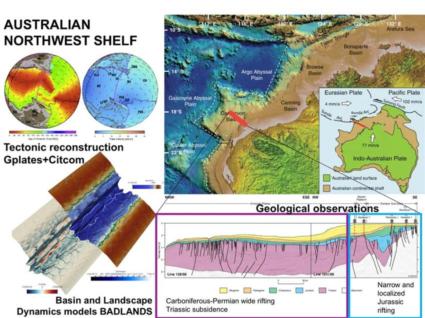
Coastal ecosystem services, Tonga ........................................................................ 29
                    Mapping coastal seagrass ecosystems using high resolution remote sensing 30
3.3         CARBON CAPTURE, SEDIMENT GEOCHEMISTRY ........................................................... 31
                    Unravelling the trace element signatures of rare CO2 traps ........................... 31
3.4         COASTAL REMEDIATION, CHEMISTRY ............................................................................. 32
                    Mining wastewaters and remediating coastal metalliferous drainage using
                    synthetic sorption materials ..................................................................................... 32
3.5         CORAL REEF GEOMORPHOLOGY.................................................................................... 33
                    HALO - Halimeda bioherm Origins, function and fate in the northern Great
                    Barrier Reef ................................................................................................................ 33
                    Morphologic evolution of the rubble cays at One Tree Reef........................... 34
                    Death by a thousand cuts: understanding the role of paleowater quality
                    (high sediment & nutrient flux) in the growth and demise of the Great Barrier
                    Reef over the past 30,000 years .......................................................................... 35
                    The origin of the Great Barrier Reef – when, where and why? ...................... 36
                    The lives and deaths of the Great Barrier Reef – combining data & models
                    to understand the evolution of Australia’s iconic reef ........................................ 37
                    The last coral reef frontier - quantitative geomorphology of the modern
                    Coral Sea reefs ......................................................................................................... 38

                     Controls on the Holocene evolution of the Great Barrier Reef: linking 4D num
                    erical modeling and observational data .............................................................. 39
                    Multi-core parallel tempering for extending BayesReef for modelling reef
                    growth on geological timescales ............................................................................ 40
3.6         MORPHODYNAMICS OF TEMPERATE COASTS ............................................................. 41
                    What is special about beaches in estuaries and bays?..................................... 41
                    What will happen to Sydney’s beaches with climate change? How can we
                    prepare? ..................................................................................................................... 42
                    Estuarine beaches of Sydney Harbour: what’s going on in Rose Bay? ........... 43

Geosciences Honours Projects 2020: Geology & Geophysics (v.09-10-19)                                                                               2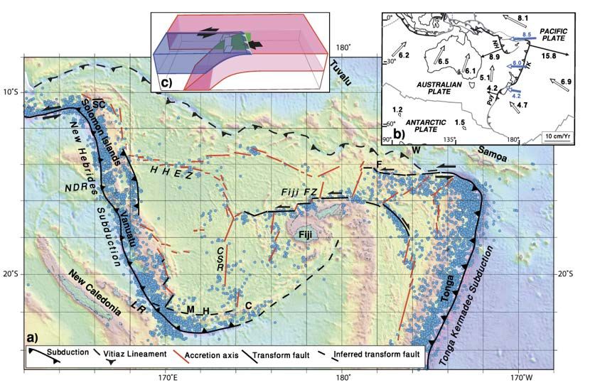
1 Honours projects

             Earthquake fault mechanics in the Sydney
         Basin
Supervisors: Vasilis Chatzaras vasilieos.chatzaras@sydney.edu.au, Patrice Rey
patrice.rey@sydney.edu.au & Martyn Drury (Utrecht University)

Sydney Basin lies within a seismically active
area experiencing earthquakes of magnitude
5.5 or greater. The recent discovery that the
$300 million nuclear reactor at Lucas Heights
is built on ancient faults, has raised public
concern.     Our limited understanding of
earthquake mechanics in such sandstone-
hosted faults, hinders quantitative assessment
of seismic hazard. The goal of this project is
to determine how fault zone architecture, fault
rock type, fluid-rock interaction, grain
cementation, and deformation mechanisms,
influence the frictional strength properties of
faults developed in sandstones. The student
will perform a multi-scale analysis of fault
zone structure, including outcrop scale characterization (cm-m) of faults within the Hawkesbury
sandstone, and analysis of deformation processes in the micro-to nanoscale using X-ray and
electron microscopy. The student will be part of an international research team from USyd and
Utrecht University (NL). The project may include a possible research visit of the student at Utrecht
University.

Geosciences Honours Projects 2020: Geology & Geophysics (v.09-10-19)                              3
Kinematic evolution of the Redbank thrust
         zone, Central Australia
Supervisors: Vasilis Chatzaras vasilieos.chatzaras@sydney.edu.au

                              The Redbank thrust zone is a key structure for
                              understanding intraplate orogeny in central Australia. It
                              comprises a 7-10 km wide and more than 350 km long
                              zone of anastomosing mylonites that has experienced a
                              complex history of multiple reactivation events since the
                              Proterozoic, and accommodated significant intraplate
                              deformation leading to 25 km vertical and 40 km lateral
                              offset of the Moho. This project aims to understand the
                              three-dimensional deformation and kinematic evolution of
                              this major shear-boundary, combining field and microscale
(SEM-EBSD, X-ray CT, EPMA) data to reconstruct the tectonic evolution of this major
intracontinental structure.

Geosciences Honours Projects 2020: Geology & Geophysics (v.09-10-19)                 4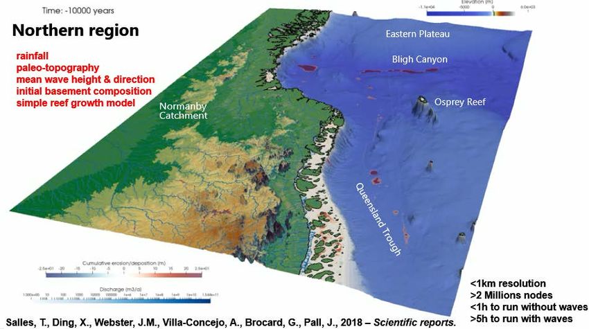
Mineralogical and chemical
         characterization of a suspected NSW meteorite
Supervisors: Vasilis Chatzaras vasilieos.chatzaras@sydney.edu.au & Geoff Clarke
geoffrey.clarke@sydney.edu.au

Meteorites are extra-terrestrial objects that can
provide important information for the formation and
earlier history of the solar system. In this project, the
student will be the first to study a suspected meteorite
recently recovered in NSW. The student will conduct
detailed characterization of the petrography,
chemistry, and structure of the suspected meteorite,
combining light microscopy (transmitted and reflected),
and beam-based techniques (e.g., scanning electron
microscopy, electron probe microanalysis, X-ray computed tomography, and X-ray diffraction).
The aim of the project is to validate the first-order identification of the rock as a meteorite and
to attempt a classification of the meteorite type.

Geosciences Honours Projects 2020: Geology & Geophysics (v.09-10-19)                             5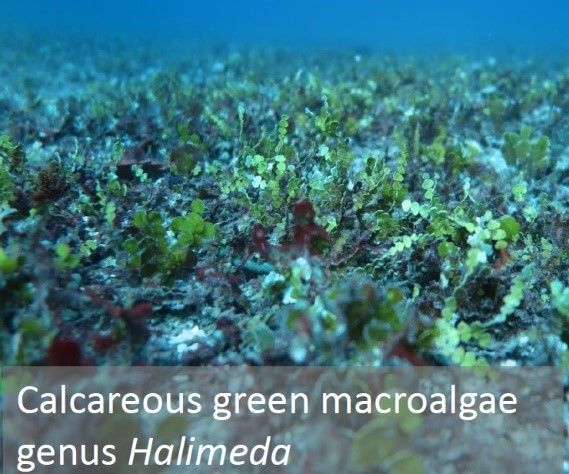
Formation of the mantle-crust transition
         zone in the New Caledonia forearc ophiolite
Supervisors: Vasilis Chatzaras vasilieos.chatzaras@sydney.edu.au & Derya Gurer (UQ)

                                          The deformation processes during the formation of the
                                          mantle-crust transition zone in forearc ophiolites are still
                                          poorly understood. In this project the student will analyse
                                          rocks from the cumulate sequence of the New Caledonia
                                          ophiolite to understand their kinematic evolution,
                                          deformation mechanisms, and mechanical heterogeneity.
                                          The student will analyse crystal orientation data acquired
                                          with the Scanning Electron Microscope - Electron
                                          Backscatter Diffraction (SEM-EBSD) technique, to
                                          characterize the microstructure and mechanical properties
                                          of the rocks comprising the mantle-crust transition zone.

Geosciences Honours Projects 2020: Geology & Geophysics (v.09-10-19)                                6
Deformation processes in a mantle shear
         zone in the Pindos forearc ophiolite, Greece
         (and a second, co-related project on
         earthquakes)
Supervisors: Vasilis Chatzaras vasilieos.chatzaras@sydney.edu.au, Basil Tikoff (University
of Wisconsin-Madison) & Joshua Davis (Carleton College)

Project 1: One of the aspects of plate tectonics that has not been explored in detail is three-
dimensional deformation in the Earth’s mantle, particularly along plate boundaries. The aim of
this project is to understand the distribution of three-dimensional strain within the oceanic
lithosphere that formed in a subduction zone system. The student will use X-ray computed
tomography, a non-destructive 3D imaging technique, to analyse the alignment and shape of
minerals from rocks that formed in the Earth’s oceanic upper mantle. These data will inform
models of 3D mantle flow in subduction zones.

Project 2: Major earthquakes that nucleate in the seismogenic layer may cause non-steady state
deformation and stress cycles in the Earth’s upper mantle. Geological evidence for such
earthquake-related episodic deformation in the upper mantle, is not well established. This
project aims to identify structures in the microscale that formed during transient deformation
events associated with stress change in the upper mantle. The student will analyse crystal
orientation data acquired with the Scanning Electron Microscope - Electron Backscatter
Diffraction (SEM-EBSD) technique, to characterize microstructures that were generated at
different stress conditions in a fault zone that deformed the Earth’s oceanic upper mantle. These
data will allow us to build a picture of the seismic cycle in the oceanic lithosphere.

Geosciences Honours Projects 2020: Geology & Geophysics (v.09-10-19)                           7
Gold in NSW
Supervisor: Derek Wyman derek.wyman@sydney.edu.au

Gold was discovered at Dargues Reef (between Canberra and Batemans Bay) in 1851 and
alluvial “pan” mining went on for decades. Now, the source deposit has been identified and will
deliver its first gold brick in early 2020. After spending a couple of days on site selecting core,
this Honours study will help to resolve questions about the nature of the deposit using geochemical
data, petrographic study and microprobe analysis. The deposit is unusual in terms of both age
and mineralization style and so will of interest to any students considering a career in the
resources industry or other applied geochemistry-related fields.

Geosciences Honours Projects 2020: Geology & Geophysics (v.09-10-19)                             8

New Perspectives on Archean Tectonics
Supervisor: Derek Wyman derek.wyman@sydney.edu.au

                                     Western Australia’s Yilgarn Craton

Over the last few years, tectonic models for Western Australia’s Yilgarn Craton have been
undergoing a dramatic revision. Given the Yilgarn’s importance as an example of Earth’s
Archean proto-continents, these new results have major implications for our understanding of how
plate tectonics emerged. The study will combine geochemical and petrographic analysis of 2.8
billion-year-old rocks to contribute to the revised stratigraphic and tectonic framework that is
being developed for the western Yilgarn.

Geosciences Honours Projects 2020: Geology & Geophysics (v.09-10-19)                          9
2 Honours projects available through the
Earthbyte group
How climate and subsidence control the
sedimentation along the Norwegian Margin?
Supervisors: Claire Mallard claire.mallard@sydney.edu.au, Tristan Salles
tristan.salles@sydney.edu.au, Sabin Zahirovic sabin.zahirovic@sydney.edu.au & John-Are
Hansen
The North Sea Basin and associated Norway
margins record extensional tectonic events from
the Paleozoic to the Early Cretaceous. A major
subsidence phase followed this rifting event
throughout the Late Cretaceous and Cenozoic,
punctuated by basin inversion episodes during the
Paleogene. Both complex tectonic and successive
glacial episodes make it hard to understand the
evolution of the source to sink systems along this
margin from pre-rift to the present day.
Pre-rift sedimentation is characterized by large Jurassic deltaic systems built out in the sea
between Norway and Greenland. Then, in the Late Jurassic and Early Cretaceous, significant
continental rifting and crustal thinning events occurred inducing a substantial change of
depositional facies from deltaic to deep environments. After break-up, glacial events also
affected the region resulting in new changes in depositional environments. A model of passive
thermal subsidence enhanced by sediment loading in the central North Sea and marginal uplift
of the Norwegian landmasses has been proposed. Nevertheless, the role of continued regional
and local tectonic activity on the break-up sedimentation is still debated and the timing of onset
of glaciation in the Cenozoic, especially for the Quaternary, remains unclear.
The goal of this project is to characterize the processes providing a fundamental control on the
drastic changes of depositional environments and sediment fluxes during the rifting history of the
Western Norway margin.The first step is to understand the post-rifting sedimentation and how
the latest glacial events affected the succession of depositional environments along the Western
Norwegian margin. We will use a regional model of the past 30 Ma to test different climate
forcing to determine the most realistic ones. The next investigation will focus on the break-up
event and how the delta systems are building out into an epicontinental sea between Norway
and Greenland, which evolved into the thick Cretaceous shale units. A range of generic models
will be designed to test the subsidence scenarios supported by the literature to determine if they
allow the same accumulation and depositional environment evolution than on the actual margin.
This project is aligned with the Basin GENESIS Hub and will involve collaboration with the oil
company Equinor.
Geosciences Honours Projects 2020: Geology & Geophysics (v.09-10-19) 10How is landscape complexity driving
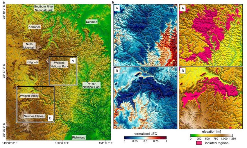
biodiversity over geological time scales?
Supervisors: Patrice Rey patrice.rey@sydney.edu.au & Tristan Salles
tristan.salles@sydney.edu.au
Mountainous landscapes have long been recognized as potential drivers for genetic drift,
speciation and ecological resilience. Yet, there is a lack of clarity on the mechanisms and
processes linking landscape complexity to biodiversity over geological time scales.
Application of the landscape complexity proxy on the Blue Mountains region (a) highlighting regions of high LEC (i.e.
higher biodiversity in b-left) and high isolation (i.e. higher speciation and endemism in b-right).
In most studies, landscape complexity has often been overlooked with species richness evolution
only quantified over static landscapes. Consequently, we are still missing a fundamental
understanding of how tectonic and surface processes convert landscapes of low elevation and
relief, low environmental gradients and continuous habitats, into topographically complex
regions of high relief with steep environmental gradients, and fragmented habitats.
Recently a new numerical approach has been proposed to assess and quantify drivers of
biodiversity, speciation and endemism over geological time scales. The method is a direct
measure of landscape complexity and seems to explain - to the first order - biodiversity in
mountainous regions over synthetic landscapes. In this project, we propose to use this new
capability (already developed in Badlands) to test its applicability over a range of different
mountainous landscapes around the world. From comparisons with available biodiversity
dataset, the project will estimate under which conditions this new landscape complexity proxy is
a good predictor of species richness. The project outcomes could potentially lead to reassessment
of the spatial viability of existing biodiversity conservation sites and could help improve future
conservation planning, policy and practice.
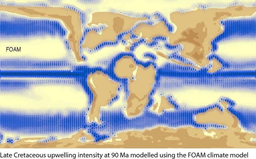
Geosciences Honours Projects 2020: Geology & Geophysics (v.09-10-19) 11Oceanic upwelling and the distribution of
deep-sea organic carbon since the Cretaceous
Period
Supervisors: Adriana Dutkiewicz adriana.dutkiewicz@sydney.edu.au & Dietmar Müller
dietmar.muller@sydney.edu.au
Late Cretaceous upwelling intensity at 90 Ma modelled using the FOAM climate model.
The distribution of sedimentary organic matter in the ocean basins through space and time is of
fundamental importance to the global carbon cycle. Deep sea sediments represent an important
sink of organic carbon, while subduction of organic carbon contributes to subduction zone
degassing of carbon back into the atmosphere. A major challenge is to better constrain the
processes that controlled organic carbon production and burial and its consequences for marine
biogeochemical cycles. Upwelling of nutrient rich deep water is the primary mechanism driving
surface ocean productivity and carbon burial. A secondary process is the influx of terrigenous
organic matter to the oceans from the continents. Previous work on organic matter accumulations
in deep sea sediments as “black shales” has led to a hypothesis that optimal conditions for black
shale deposition should occur where in the outer tropical climate zones and in areas of coastal
upwelling with strong forcing by surface winds (Wagner et al., 2013).
This project is designed to test this hypothesis by combining the outputs of a set of global climate-
ocean models run using the Fast Ocean Atmosphere Model (FOAM) with deep-sea sedimentary
organic carbon data from ocean drilling sites. Climate model outputs include predicted grids of
the past distributions and intensity of upwelling through time as well as water runoff from the
continents. The objective is to determine spatio-temporal correlations between total sedimentary
organic carbon content with key parameters such as the predicted upwelling intensity and
latitude, proximity to continents, including whether continents occur to the west or the east of a
given region (upwelling tends to be more pronounced along eastern boundary currents) and
regional continental runoff. This will lead to a predictive approach for mapping the reservoir of
deep-sea organic carbon through time, as well as its subduction flux. The methodology will build
on those developed for oceanic crustal carbon and sedimentary carbonate carbon
Geosciences Honours Projects 2020: Geology & Geophysics (v.09-10-19) 12reconstructions in the EarthByte Group. This project will involve collaboration with Prof
Christopher Scotese (Director, Paleomap Project) and assistance with workflow development by
Michael Chin, and will lead to further opportunities as part of the Basin Genesis Hub and the
EarthByte Group’s work on deep carbon and long-term climate change.
References
1. Dutkiewicz, A., Müller, R.D., Cannon, J., Vaughan, S. and Zahirovic, S., 2018.
Sequestration and subduction of deep-sea carbonate in the global ocean since the Early
Cretaceous. Geology, 47(1), pp.91-94.
2. Müller, R.D. and Dutkiewicz, A., 2018. Oceanic crustal carbon cycle drives 26-million-
year atmospheric carbon dioxide periodicities. Science Advances, 4(2), p.eaaq0500.
3. Wagner, T., Hofmann, P., & Flögel, S., 2013, Marine black shale deposition and Hadley
Cell dynamics: A conceptual framework for the Cretaceous Atlantic Ocean. Marine and
Petroleum Geology, 43, 222-238.
Geosciences Honours Projects 2020: Geology & Geophysics (v.09-10-19) 13Vertical motions of the Tasman and Coral
Sea: possible link to Ontong Java Plateau
collision?
Supervisors: Maria Seton maria.seton@sydney.edu.au & Jody Webster
jody.webster@sydney.edu.au
The collision of the world’s largest Large
Igneous Province, the Ontong Java
Plateau (OJP), with the Melanesian Arc is
proposed to have caused subduction
polarity reversal along the South
Solomon Trench, leading to a cascade of
events such as a change in direction of the
Australian plate, ore-deposit formation
along the Melanesian Arc, and possibly a
reorganisation of the entire plate-mantle
system. Although this major tectonic event
is well-recognised in the literature, determining the timing of plateau accretion is difficult as
three independent approaches (palaeomagnetics, marine geophysics and onshore geology)
yield timings that differ by over 30 million years.
In this project, you will use a novel and multi-disciplinary approach to explore the far-field effect
of this collision on the vertical motions of the submarine seamounts and ridges in the Tasman and
Coral Seas. You will integrate age and paleo-environment data from recently collected
sedimentary samples and construct alternative plate kinematic models of the OJP collision in
GPlates. The reconstructions will be fed into geodynamic models of mantle structure and the
dynamic topography predictions will be compared to your paleo-environmental data. This
project involves collaboration with colleagues from the University of Wollongong.
Geosciences Honours Projects 2020: Geology & Geophysics (v.09-10-19) 14How has subduction influenced the opening
of the Drake Passage?
Supervisors: Maria Seton maria.seton@sydney.edu.au & Dietmar Müller
dietmar.muller@sydney.edu.au
Oceanic gateways are narrow connections
between neighbouring oceans and focal areas
for the large-scale exchange of water, heat,
salinity and nutrients between ocean basins.
Their opening and closure, which is largely
driven by plate tectonic processes, is thought to
be responsible for abrupt climate shifts by
altering ocean circulation leading to a change
in the distribution of heat, moisture and CO2 in
the world’s oceans and atmosphere. However,
understanding the relationship between
tectonics and climate is strongly dependent on
accurate reconstructions of gateway
morphology and their margins, which remain
poorly constrained.
In this project, you will explore the relative role of subduction on the Drake Passage and its
margins and examine how subduction processes such as back-arc opening and slab window
formation may have influenced both the timing of deep-water flow between the Pacific and
Atlantic Oceans and the signatures indicating continental separation from the geological record.
As part of this project you will develop a new set of plate reconstructions with a particular focus
on incorporating the subduction history of southern South America and the Antarctic Peninsula,
map the migration of slab windows and create a series of paleobathymetry and
palaeoelevation models for the region. You will develop skills in plate tectonic modeling and
data synthesis and learn software tools such as GPlates, ArcGIS and GMT. This project could be
a catalyst for further studies in using your results as boundary conditions into paleoclimate
modelling software.
Geosciences Honours Projects 2020: Geology & Geophysics (v.09-10-19) 15The tectonic and surface process evolution
of Papua New Guinea
Supervisors: Sabin Zahirovic sabin.zahirovic@sydney.edu.au & Dietmar Müller
dietmar.muller@sydney.edu.au
The New Guinea margin has
experienced a complex tectonic
history due to the convergence
between the Indo-Australian,
Eurasian and Pacific plates since the
breakup of the Pangea
supercontinent. The inaccessible
terrain in Papua New Guinea,
coupled with poor rock exposure due
to extreme weathering in the tropical
humid belt, result in poorly-
constrained models of the regional
tectonic and topographic evolution.
However, the Papuan Fold and Thrust Belt and the Gulf of Papua host some of the world’s most
promising energy resources, meaning that the latest modelling approaches must be applied to
help demystify the nature and chronology of major tectonic events that have shaped the region.
Tectonic reconstructions in GPlates that include end-member estimates of lithospheric deformation
will be linked to landscape evolution models in Badlands, with additional time-evolving boundary
conditions applied from CitcomS mantle flow models. The timing and magnitude of (Eocene or
Oligocene) deformation related to the collision on the Papuan Peninsula, as well as the Late
Cretaceous to Eocene rifting in the western Coral Sea, will inform the time-dependent tectonic
topography boundary condition applied to the Badlands models. The predicted stratigraphy will
be compared to interpretations of regional seismic sections with the aim of identifying the most
plausible tectonic scenarios, as well as help inform paleogeographic interpretations and resource
exploration for the north-eastern margin of the Australian continent. This project is firmly aligned
with the Basin GENESIS Hub, and will involve close collaboration with Oil Search who is our key
industry partner for the New Guinea region.
Geosciences Honours Projects 2020: Geology & Geophysics (v.09-10-19) 16The role of mechanical stratigraphy in the
structural style and development of fold and
thrust belts
Supervisors: Patrice Rey patrice.rey@sydney.edu.au & Luke Mahoney (Oil Search)
The strong variability in the structural style (fold geometries, fault patterns,
etc.) of fold and thrust belts is in large part due to the rheological contrasts
that can exist between evaporites, shales, sandstones, limestones and volcanic rocks that
accumulate in sedimentary basins. The inversion, via forward modelling, of the structural style
imaged through seismic methods, can help constrain the mechanical stratigraphy of basins. In this
project, the student will use high-performance computers, and open source numerical codes such
as Underworld. The aim is to define, via a simple inversion protocol, the mechanical stratigraphy
of the fold and thrust belt in Papua New Guinea. This project is a collaboration between the
Basin Genesis Hub and Oil Search, a Sydney-based oil and gas exploration company.
Geosciences Honours Projects 2020: Geology & Geophysics (v.09-10-19) 17Lithospheric mechanical layering and
mountain building processes
Supervisors: Patrice Rey patrice.rey@sydney.edu.au & Vasilis Chatzaras
vasilieos.chatzaras@sydney.edu.au
The topography of continents is the expression of geodynamic and tectonic processes deforming
the continental lithosphere. How the continents deform depends on their mechanical properties
and their thermal state. A number of rheological models have been proposed for the continental
lithosphere varying from the “crème brulée” model, in which the strong upper crust stands above
a much weaker lower crust and weaker mantle, to the “jelly sandwich” model, in which a much
weaker lower crust separates the stronger upper mantle from the stronger upper crust. In this
project, we propose to explore the role of
the lithospheric mechanical layering on
collisional processes. The candidate will
design, run, analyse and compare
simulations of continental collision involving a
range of rheological layering. Results will be
compared to a number of orogens including
the Himalayas-Tibet and central Anatolia.
Geosciences Honours Projects 2020: Geology & Geophysics (v.09-10-19) 18Effect of mechanical layering on
lithospheric coupling in strike-slip fault systems
Supervisors: Patrice Rey patrice.rey@sydney.edu.au & Vasilis Chatzaras
vasilieos.chatzaras@sydney.edu.au
Major strike-slip faults extend through the crust, offsetting the Moho, and may even offset the
lithosphere-asthenosphere boundary. As
such, these structures require some type of
mechanical communication between crust
and mantle. In this project we propose to
explore the effect of the rheological
structure of strike-slip fault zones on the
mechanical interaction and degree of
coupling between the different lithospheric
layers (i.e. upper crust, lower crust, and
upper mantle). You will run numerical
models of deformation in lithospheric-scale
strike-slip faults using a range of
mechanical stratifications. You will
compare the results of the simulations with observations from major strike-slip faults, such as the
San Andreas fault (USA) and the North Anatolian fault (Turkey). High-performance computers,
and open source numerical codes such as Underworld will be used to run the simulations. In this
project you will develop skills in: 1) geodynamic modelling, and 2) analysis of deformation in
transform settings.
Relevant literature
- Chatzaras, V., Tikoff, B., Newman, J., Withers, A.C., Drury, M.R., 2015. Mantle strength
of the San Andreas fault system and the role of mantle-crust feedbacks. Geology, 43,
891–894, doi:10.1130/G36752.1.
- Rey, P. F., Mondy, L., Duclaux, G., Teyssier, C., Whitney, D.L., Bocher, M. and Prigent,
C., 2017. The origin of contractional structures in extensional gneiss domes. Geology,
v.45, DOI: 10.1130/G38595.1.
Geosciences Honours Projects 2020: Geology & Geophysics (v.09-10-19) 19Multi-core parallel tempering for
extending BayesReef for modelling reef
growth on geological timescales
Supervisors: Rohitash Chandra rohitash.chandra@sydney.edu.au & Jody Webster
jody.webster@sydney.edu.au
Estimating the impact of environmental processes on vertical reef development in geological
timescales is a very challenging task. This is due to complex models and data with missing
information. py-Reef Core is a vertical reef growth simulation model for geological timescales.
BayesReef has been proposed to estimate and provide uncertainty quantification for py-Reef
Core which features environmental condition parameters. BayesReef features limitations when
the size of the problem increases due to computational requirements in sampling and hence only
a few parameters were estimated. Parallel tempering (PT) is an advanced MCMC method suited
for irregular and multi-modal distributions. Moreover, PT is more suitable for multi-core
implementations that can speed up computationally expensive geophysical models. The Honours
research project extends Bayeslands using parallel tempering to estimate dozens of parameters
on a synthetic reef core dataset.
Geosciences Honours Projects 2020: Geology & Geophysics (v.09-10-19) 20Understanding the link between plate
tectonics and landscape-basin evolution
Supervisors: Sara Morón sara.moronpolanco@sydney.edu.au, Sabin Zahirovic
sabin.zahirovic@sydney.edu.au, Tristan Salles tristan.salles@sydney.edu.au & Chris Elders
(Curtin University)
Sedimentary basins capture the Earth’s tectonic and landscape history and host a range of
resources of critical importance for the continued functioning of modern society.
The sedimentary basins of the North West Shelf (NWS) of Australia contain an exceptional
record of multiple phases of rifting associated with supercontinental breakup. These multiple rift
phases which span from the Permian to Cretaceous exhibit contrasting structural and
stratigraphic styles. This contrasting record offers an excellent opportunity to investigate the link
between plate tectonics and landscape-basin evolution. This project will use a combination of (i)
plate tectonic reconstructions, (ii) basin and landscape dynamics numerical models and (iii) a
synthesis of geological observations to unravel the link between plate tectonics and landscape-
basin evolution. Models will allow exploring (i) how temporal structural changes can be
associated to changes in the direction of rifting, (ii) how variations in the stratigraphic record are
the result of variations in the flux of sediments from the continent interior to the continental margin
and (iii) the interaction between plate tectonics and landscape-basin evolution. This project
provides an extraordinary opportunity to learn about tectonics and surface processes with
cutting-edge software tools, which will give students a valuable set of skills that are important
for both academia and industry.
Geosciences Honours Projects 2020: Geology & Geophysics (v.09-10-19) 21Fingerprinting the closure of the Central
American Seaway
Supervisors: Sara Morón sara.moronpolanco@sydney.edu.au, Maria Seton
maria.seton@sydney.edu.au & Tristan Salles tristan.salles@sydney.edu.au
The Central American Seaway facilitated the exchange
of water, heat, salinity and biota between the Pacific
and Atlantic oceans. The closure of this oceanic gateway,
at the Isthmus of Panama, has been attributed to the
onset of northern hemisphere glaciation, the formation of
North Atlantic Deep Water and the great biotic
exchange between North and South America during the
Pliocene. However, the timing of gateway closure is
controversial with ages ranging from Paleocene-Eocene
through to the Pliocene, requiring a rethink of our
understanding of global ocean circulation patterns and
biotic exchange through this gateway. You will attempt
to address this controversy by comparing mapped
fluvial systems from southern North America and
northern South America with results from landscape
evolution software, Badlands. You will acquire a wide
variety of skills in data synthesis and numerical modelling (GPlates, Badlands, GMT). This project
forms part of the ARC-funded Basin Genesis Hub.
Geosciences Honours Projects 2020: Geology & Geophysics (v.09-10-19) 22A newly discovered plate boundary in the
North Fiji Basin - why is it there ?
Supervisors: Maria Seton maria.seton@sydney.edu.au & Julian Giodmai
The most complex
arrangement of mid-ocean
ridges on Earth exists in the
late Miocene-present
North Fiji Basin. While
many of the spreading
centres have been mapped
through a combination of
earthquake focal
mechanisms, high-
resolution geophysical
data, and direct sampling,
others have been inferred.
One such example is an
accretionary axis close to
the New Hebrides subduction zone. In this project, you will interpret newly collected marine
geophysical data from the North Fiji Basin to map a newly discovered plate boundary and then
use numerical experiments using Underworld to explore whether the collision of the Loyalty Ridge
could led to the arrangements of plate boundaries we currently observe in the southwest North
Fiji Basin. The results of the experiments will help inform on the dynamics of arc collision and
overriding plate deformation. As part of this project, you will acquire skills in marine geophysical
data analysis, GIS and numerical modeling. These skills will help prepare you for working in the
exploration industry, consulting firms, government agencies or universities. This project will involve
close collaboration with colleagues from the University of Melbourne.
Geosciences Honours Projects 2020: Geology & Geophysics (v.09-10-19) 23Coupling pyGPlates with thermal diffusion
models: a case study on how subduction rates
impact the thermal regime in Alaska.
Supervisors: Ben Mather ben.mather@sydney.edu.au & Dietmar Müller
dietmar.muller@sydney.edu.au
The present-day temperature distribution
of the Earth’s lithosphere inherits
geological processes that have occurred
tens of millions of years ago. Recent
seismic data acquired in Alaska capture
two horizons that obscure the Moho, which
is probably related to interference with
the eastward-subducting slab. In this
project, the candidate will use pyGPlates
to interrogate the position and velocity of
the subducting slab through the last 80
million years and couple a simplified
model of thermal diffusion to simulate the
thermal evolution of the lithosphere. The
region is currently thermally active, as
shown by the presence of numerous hot
springs, but very little is known about the
composition of the lithosphere in Alaska. By merging pyGPlates with a model of thermal diffusion
that assimilates multiple observations related to temperature (e.g. Curie depth, heat flow
measurements, crustal thickness) the candidate will be able to quantify the present-day thermal
regime to some degree of uncertainty. The project will develop the candidate’s skills in the
Python programming language and Bayesian inference. This project will be undertaken in close
collaboration with researchers at the Australian National University in Canberra.
Geosciences Honours Projects 2020: Geology & Geophysics (v.09-10-19) 24Inverting the present-day temperature
distribution in Australian crust at unprecedented
resolution.
Supervisors: Ben Mather ben.mather@sydney.edu.au & Dietmar Müller
dietmar.muller@sydney.edu.au
Understanding the thermal structure of the crust is key to informing regions that are desirable
for geothermal exploration or hydrocarbon maturity. Furthermore, temperature is a requirement
to ascertain the rheology of the crust to identify regions that are more susceptible to
deformation. Despite there being numerous attempts to characterise the temperature distribution
in Australia, the thermal structure of the crust in Australia is relatively unknown. Most temperature
maps ignore the geological complexity of different terranes and sedimentary basins within
Australia and focus only in the top 5km of the crust. In this project, the honours candidate will
invert the temperature of Australia’s crust using high performance computing (HPC) infrastructure.
The project will leverage an in-house Python code developed to efficiently find an optimal
temperature solution, subject to available data, which also produces uncertainty estimates. This
project will develop the candidate’s skills in the Python programming language and Bayesian
inference. This project will be undertaken in close collaboration with researchers at the Australian
National University in Canberra.
Geosciences Honours Projects 2020: Geology & Geophysics (v.09-10-19) 253 Honours projects available through the
Geocoastal Research Group (GRG)
This is a non-exhaustive list of possible research projects in the Geocoastal Research
Group (GRG). Please note that most projects can be tailored to suit your passion, expertise and
research program (i.e., Honours, Master’s, Phd), and that we might be happy to supervise you
on a different project. Come and talk with us if you are interested in any specific project
or other broad research theme.
By undertaking a research project with us, you will become a member of the GRG, while also
interacting with other research groups within and outside of the school as relevant to your project.
Our research students participate in our numerous field campaigns each year. Therefore, even
if your project does not specifically include fieldwork, you will have plenty
of optional opportunities to go to the field. In the last few years, we have had students
participating in fieldwork campaigns in temperate and tropical coasts around Australia and the
world.
Marine Science is a multidisciplinary research area, which at The University of Sydney
mostly comprises Marine Biology and Marine Geosciences. Many of our projects on marine
geosciences link directly with marine biology so your bio/geo background might be a strength!
Most importantly, with our research projects you can choose to learn a set of skills to suit your
future and those include fieldwork skills, numerical modelling, coding, GIS.
Come join us on our quest to undertake Marine Geoscience all around the world!
http://grgusyd.org/
GRG’s fieldwork sites around the world
Geosciences Honours Projects 2020: Geology & Geophysics (v.09-10-19) 26Constraining the size of tsunami generated
by the Wide Bay Submarine Landslide
Supervisors: Tom Hubble tom.hubble@sydney.edu.au
Constraining the size of tsunami generated by the Wide Bay Submarine Landslide
(Mid-Year start post-RV Investigator July-2020 cruise).
Geosciences Honours Projects 2020: Geology & Geophysics (v.09-10-19) 273.2 BLUE CARBON
Spatio-temporal patterns of
coastal slatmarsh and mangrove biomass
Supervisors: Eleanor Bruce eleanor.bruce@sydney.edu.au & Kevin Davies
kevin.davies@sydney.edu.au
Mangroves and saltmarshes are major sources of organic carbon that are important for global
strategies to mitigate global warning. Global degradation and loss of these critical ecosystems
have reduced organic carbon stocks potentially increasing release of CO2 into the atmosphere.
In addition, the ability of tidal communities, such as mangroves, to transgress inland under
changing sea levels, will also impact on these environments. In urban environments, such as
Sydney, coastal squeeze resulting from development pressures reduces the lateral space
(accommodation space) for transgression of mangroves and other intertidal
ecosystems. Assessing above ground carbon in mangrove and saltmarsh areas requires fine
scale measurement of biomass. In the absence of detailed systematic field surveys, satellite and
UAV borne sensors can be used to characterise patterns of aboveground biomass.
Current understanding of how saltmarsh and mangrove biomass varies across fine spatial and
temporal scales and the drivers behind these trends is limited. This research project would
contribute to methods for characterising spatio-temporal variability in biomass estimates in
saltmarsh and mangrove communities in the Sydney Harbour and Parramatta River using ultra
high-resolution UAV data, broader scale satellite imagery and field survey. This project presents
an opportunity to work closely with industry partners involved in UAV and satellite data capture
(Arbour Carbon) and other marine research institutes.
Research partners: ARC Training Centre for Cubesats, UAVs and Their Applications (CUAVA),
Arbor Carbon, UWA Oceans Institute & Australian Institute of Marine Science (AIMS)
http://www.cuava.com.au/
Geosciences Honours Projects 2020: Geology & Geophysics (v.09-10-19) 28Coastal ecosystem services, Tonga Supervisors: Eleanor Bruce eleanor.bruce@sydney.edu.au, Kevin Davies kevin.davies@sydney.edu.au & John Duncan Susceptibility to climate variability and extremes is acutely felt by many natural resource-dependent coastal communities of the South Pacific. Livelihood and food security in these environments are inextricably linked with coastal ecosystem health. Focused on mangrove ecosystems, this project would involve the use of Earth observation data to examine the influence of biophysical interactions operating in inter-tidal environments on local livelihood and food security in Tongan coastal communities. This would potentially involve integrating remotely sensed indicators of ecosystem status and qualitative information on subsistence usage patterns, fishing activities and land use practices, to investigate key socio-ecological system interlinkages and beneficiaries of coastal ecosystem services. Funding is available to support field travel. https://livelihoodsandlandscapes.com/fiji-and-tonga/ Geosciences Honours Projects 2020: Geology & Geophysics (v.09-10-19) 29
Mapping coastal seagrass ecosystems
         using high resolution remote sensing
Supervisors: Eleanor Bruce eleanor.bruce@sydney.edu.au, Kevin Davies
kevin.davies@sydney.edu.au & John Duncan

                                                 Extensive meadows of seagrass in shallow
                                                 coastal waters provide important ecosystem
                                                 services that directly or indirectly benefit human
                                                 needs, particularly in the stabilisation of
                                                 nearshore sediments and as nursery grounds for
                                                 commercial fish species. Previous research has
                                                 shown that the spatial patterning and species
                                                 present within seagrass meadows can influence
the ecosystem service flows from these environments. For example, do well established
meadows vs. areas comprising smaller colonising species provide habitat characteristics that
support commercially important fish or stabilise sediments? There has been no systematic review
of seagrass ecosystem service provision in the South Pacific. High resolution bathymetric (LiDAR)
data and satellite imagery (Digital Globe) are available that cover extensive seagrass
meadows in the nearshore area of Tongatapu, Tonga. Spatial modelling and remote sensing-
based research on these coastal seagrasses can provide valuable insight on species composition,
benthic substrates and other variables that influence the ecosystem service contributions for local
communities.

Funding is available to support field travel.

Geosciences Honours Projects 2020: Geology & Geophysics (v.09-10-19)                            30
3.3 CARBON CAPTURE, SEDIMENT GEOCHEMISTRY
Unravelling the trace element signatures of
rare CO traps 2
Supervisors: Bree Morgan bree.morgan@sydney.edu.au, Jessica Hamilton (ANSTO)
& Siobhan Wilson (U Alberta)
Highly-stable Mg-carbonate minerals, such as magnesite
(MgCO3) and dolomite (CaMg(CO3)2), are ideal safe and
permanent sinks for CO2, but their formation is kinetically
restrained under Earth’s surface conditions. Despite this,
they are found as rare modern precipitates in ephemeral
playa lake sediments in Australia and Canada. Their
occurrence in both environments despite the extreme
contrasts between geochemical, lithological, topographic
and climatic conditions, provides the ideal natural settings
to unravel the underlying mechanisms driving their
formation.
Accumulation and
fractionation of trace
elements (including the
rare earth elements) can provide powerful insights into
biogeochemical processes and conditions impacting coastal
sediments. In this Honors project, trace element signatures
will be mapped in modern sediments containing both
dolomite and magnesite, along with fringing microbialites,
collected from the Coorong Lakes in South Australia, and
the Cariboo in British Columbia. The aim will be to build on
our fundamental understanding of biogeochemical
conditions that drive the safe and permanent capture of
CO2 in environmentally friendly minerals. This will be
critical for innovating efficient and affordable carbon
capture and storage strategies to mitigate the impacts of
CO2 pollution and global warming. Additionally, this fundamental knowledge will substantially
build our scientific understanding of carbonate sediments as a CO2 sink over geologic
timescales.
Geosciences Honours Projects 2020: Geology & Geophysics (v.09-10-19) 313.4 COASTAL REMEDIATION, CHEMISTRY
Mining wastewaters and remediating
coastal metalliferous drainage using synthetic
sorption materials
Supervisors: Bree Morgan bree.morgan@sydney.edu.au & Jessica Veliscek-Carolan
(ANSTO)
Acidic drainage from acid sulfate soils and mining
activities is a considerable source of trace metal
pollution to sensitive coastal ecosystems. Ideally, the
treatment of metalliferous drainage would not only
prevent the release of toxic metals to downstream
environments, but would also recover and recycle them
as a valuable resource for use in other industries. While
materials have been developed for removal of toxic
heavy metals from environmental waters based on
polymers or silica, they are often unstable in the
presence of acid. On the other hand, titanium dioxide
(TiO2) is known to have a high affinity for trace metals
when coated with specific ligands, and its stability over
a range of pH conditions makes it a potentially ideal
candidate for remediation of acidic metalliferous drainage. However, behaviour of this material
in complex natural systems is poorly understood, and optimisation for metal uptake under a wide
range of environmental conditions needs to be achieved. This project will combine laboratory
and field experimentation to optimise functionalised titania as a stable trap for trace metals in
drainage from acutely acidified coastal landscapes in Northern NSW. Research will be
undertaken collaboratively between the University of Sydney and ANSTO (the Australian
Nuclear Science and Technology Organisation). Interested students must be willing to travel to
ANSTO, Lucas Heights, to conduct their laboratory work.
Project laboratory work will be conducted at ANSTO, Lucas Heights.
Possible AINSE $5,000 stipend available through competitive application.
Geosciences Honours Projects 2020: Geology & Geophysics (v.09-10-19) 323.5 CORAL REEF GEOMORPHOLOGY
HALO - Halimeda bioherm Origins,
function and fate in the northern Great Barrier
Reef
Supervisors: Jody Webster jody.webster@sydney.edu.au, Luke Nothdurft (QLD University of
Technology) & Robin Beanab (UQLD)
Calcareous green macroalgae genus Halimeda
Calcareous green alga Halimeda is a major contributor to coral reef shelf sediments and is
found along the entire Great Barrier Reef (GBR), Australia. Previous studies of extensive
Halimeda deposits, or bioherms, show they represent important inter-reef habitats and potential
carbon sinks in the GBR Marine Park, covering ~26% of the northern shelf, equal to the modern
coral reef system. Pioneering work in 70-80s indicate the bioherms are in depths of ~20-40 m
forming linear ridges and flat-topped mounds ~20 m thick.
However, new bathymetry data reveals a completely different picture of their morphology,
characterised by complex reticulate (honeycomb-like) shapes and covering an area >3X
original estimates. These new findings confirm the Halimeda bioherms are much larger and more
complex than previously thought – challenging existing paradigms as to their origin,
development and significance. We will study these enigmatic features, building directly on a
recently funded (US$2.5 mill) RV Investigator cruise scheduled for May-June 2020. We will
conduct high-resolution multibeam mapping, subbottom profiling, sediment coring and innovative
seabed/habitat imaging (AUVs, ASV, ROV). This will increase our understanding of the
fundamental processes that control bioherm development, and have direct implications for
environmental managers tasked with predicting how these poorly studied inter-reef environments
might respond to future climate change.
Note: multiple opportunities exist to join the voyage on the RV Investigator next year and then
undertake post cruise research on the data and samples as part of your hons, Mphil or PhD
project(s). The HALO project is also funded by an $150,000 grant from the Ian Potter Foundation
to support pre- and post cruise activities and science.
Geosciences Honours Projects 2020: Geology & Geophysics (v.09-10-19) 33Morphologic evolution of the rubble cays
at One Tree Reef
Supervisors: Ana Vila-Concejo ana.vilaconcejo@sydney.edu.au & Tristan Salles
tristan.salles@sydney.edu.au
One Tree Reef in the
Southern Great Barrier
Reef has two rubble
cays: One Tree Island is
located on its SE corner,
and Two Tree Island is
located on its NE flank.
They are both composed
of unconsolidated
sediment that is
deposited under high
energy conditions. We
have a collection of
remotely sensed images
that can be used to
determine the decadal evolution of the islands; we also have some annual measurements taken
over the last few years using state-of-art techniques such as real time kinematic positioning
systems and structure from movement remote sensing using kites. This project encompasses
analysing the decadal and annual evolution of One Tree Island in relation with the wave climate
and cylonic events.
Geosciences Honours Projects 2020: Geology & Geophysics (v.09-10-19) 34Death by a thousand cuts: understanding
the role of paleowater quality (high sediment
& nutrient flux) in the growth and demise of the
Great Barrier Reef over the past 30,000 years
Supervisors: Jody Webster jody.webster@sydney.edu.au, Dirk Erler (Southerb Cross
University) & Greg Webb (UQLD)
Exp. 325 revealed that the Great Barrier Reef (GBR) had a complex and dynamic history of
reef growth and demise over the past 30 kyr, characterized by five distinct reef sequences.
Reef death occurred in two ways: subaerial exposure caused by sea-level fall or due to rapid
sealevel rise and associated environmental changes. Previous work highlighted the importance
of high sediment flux and poor water quality, rather than abrupt sea-level rise alone, in
ultimately determining reef demise. The objective of this project is to investigate the role of
paleowater quality (sediment and nutrient flux) had in controlling the evolution of the GBR over
the past 30 ky. We will investigate fossil coral reef material for IODP Expedition 325 (Great
Barrier Reef Environmental Changes) to: (1) reconstruct a unique, high-resolution record of
sediment and nutrient flux to the reef using a suite of geochemical proxies (major trace and rare
earth elements, nitrogen isotopes); and (2) relate the changes in paleowater quality to changes
in reef communitie s, accretion and bioerosion, that ultimately led to reef demise. This project
will greatly improve our understanding of the critical environmental thresholds that led to reef
demise in the past and how reefs recovered after disturbances on different spatio-temporal
scales.
Note: this project is funded by new ANZIC IODP Legacy grant to support analyses on the fossil
core reefs cores.
Geosciences Honours Projects 2020: Geology & Geophysics (v.09-10-19) 35You can also read


