Geospatial Analyzing of Straits Shipping Paths for Integration of Air Quality and Marine Wildlife Conservation
←
→
Page content transcription
If your browser does not render page correctly, please read the page content below
Volume 5 (1): 63-80 (2021) (http://www.wildlife-biodiversity.com/)
                                                                                                                Research Article

Geospatial Analyzing of Straits Shipping Paths for
Integration of Air Quality and Marine Wildlife Conservation

Mehrdad Hadipour1*, Morteza Naderi2, Mazlin Mokhtar3, Lee Khai Ern3

1
    Department of Environment, Faculty of Biological Science, Kharazmi University, Iran
2
 Department of Environmental Sciences, Faculty of Agriculture and Natural Sciences, Arak
University, Arak 38156-8-8349, Iran
3
 Institute for Environment and Development (LESTARI), National University Malaysia (UKM),
Bangi, 43600 Selangor, Malaysia
*Email: mhadipour50@yahoo.com
Received: 5 Septembert 2020 / Revised: 3 November 2020 / Accepted: 14 November 2020 / Published online: 14 November 2020.
Ministry of Sciences, Research and Technology, Arak University, Iran.

How to cite: Hadipour M, Naderi M, Mokhtar M, Khai L. (2021). Geospatial Analyzing of Straits Shipping Paths for Integration of Air Quality
and Marine Wildlife Conservation, 5(1), 63-80. https://doi.org/10.22120/jwb.2020.135939.1184

Abstract
This paper develops a GIS-based model to determine suitable locations for shipping paths within
Malacca Strait by investigating the best air quality. The mathematical and geospatial approach is
used to identify a reasonable relationship between air quality and Dugong's habitat location.
Various factors with different levels of influence and degrees of importance were established as
criteria. The chosen region of study, Malacca Strait, the world's second-busiest commercial
shipping channel, undertakes several statistical and mathematical analyses of vessel transportation
that focus on air quality concerning the main marine animal of Strait (Dugong), using the
geographic information system (GIS) as a visualization platform. The distance from the maritime
paths to the dugong home range is modeled based on NOx's factor as the primary air pollutant of
shipping emissions from moving vessels in the sea. The results took into consideration the main
negative environmental elements in shipping paths. The minimum calculated distance serves as a
constraint to indicate where the dugongs' habitats cannot be located. The result is that too many
parts of the probability of suitable Dugong habitat in the study area do not have a proper position
that does not put it in conflict with shipping polluted zones. This research has successfully
managed and developed a scientifically based method for understanding the relationship between
64| Journal of Wildlife and Biodiversity 5 (1): 63-80 (2021)

wide life habitat and marine transportation by analyzing successful and non-successful present and
future shipping.

Keywords: GIS-based modeling; Malacca Strait; Dugong

Introduction
Straits as the maritime transportation corridors are among the essential types within the context of
environmental issues. Because the contribution of Straits maritime transport to air pollution is too
crucial for the sustainability of the debate in the transport sector (Miola & Ciuffo, 2011), an
effective environmental strategy for straights humans and marine biodiversity is necessary. This
policy strategy can regulate air emissions where straights are located.
Many researchers have considered the environmental impacts of air pollution created by vessels
to be one of the most significant environmental elements. Saxe and Larsen (2004) applied an
operational meteorological air quality model (OML) to calculate air pollutants' dispersion emitted
by vessels in 3 ports. Emissions impacts of NOx and particulate matter on human health have been
investigated in this research. Matthias et al. (2010) used a regional chemistry transport model to
investigate the annual pollution emissions impact of ships in the North Sea's coastal areas. They
found that ships' emissions significantly increase air pollution due to secondary inorganic
aerosols in the study area.
Miola and Ciuffo (2011) evaluated the geographic characterization of pollutants emissions
utilizing the classification of primary methodologies based on the approach used (bottom-up or
top-down). These studies also lack a strong focus on the Strait environment. The main
environmental impacts of vessel air pollution in the straight are focused on marine biodiversity.
The model is developed so that the main element is the optimum distance of the shipping path
from the seaside to prevent air pollution-related air pollution-related to shipping in proximity to
the habitat.
The chosen region of study, Malacca Strait, the world's second-busiest commercial shipping
channel, runs through Thailand's territorial waters. To minimize threats to dugongs and seagrass
in this region, Thailand, Indonesia, Singapore and Malaysia should work together regarding its
management. The Malacca Strait has the following characteristics that align with the developed
model and environmental factors. Today, Malacca Strait (with approximately 600 vessels using it
each day) is the world's second-busiest commercial seaway (MDM, 2015).
Fifty years ago, this Strait was abundant in seagrass, which probably supported a substantial
Dugong population (Solvay et al., 2008). The Dugong is primarily a marine mammal that inhabits
typically shallow waters, remaining at depths of around 10 m, although Dugongs occasionally
dive to depths of 39 m to feed. Conservation Union (Marsh & Sobtzick, 2015) has listed the
World Dugong species as vulnerable to extinction globally. Their primary source of nourishment
and optimal habitats are Seagrass beds consisting of phanerogamous seagrasses. Dugongs are also
observed in deeper water where the continental shelf is broad, sheltered, and neritic. Different
activities use different habitats; for example, their potential areas suitable for calving are tidal
sandbanks and estuaries (relatively shallow).
Dugongs are primary consumers and the only entirely herbivorous marine mammals. They
consume seagrass, particularly of the families Potamogetonaceae and Hydrocharitaceae in the
genera Halophila and Halodule. They also have a low metabolism. When seagrass is scarce,

65| Journal of Wildlife and Biodiversity 5 (1): 63-80 (2021)

dugongs also eat marine algae. They are speculated to supplement their diet with invertebrates
such as polychaete worms, shellfish, and sea squirts, which live in seagrasses. They require a
territory with 0.4 ha of seagrass (Lawler et al., 2002, Marsh et al., 2002).
Maritime transportation is too essential for several purposes of militaries, commercial and
industrial organizations. This importance has resulted in restricted access to commercial seaways
and ports. Despite access importance to commercial marine areas and ports, there has not been
sufficient research focus on this issue, and there is only indirect studies by a few researchers
during the marine or coastal researches. As the number of vessels in maritime transportation
increases, their environmental impacts also increase. As mentioned earlier about the Malacca
strait, average of 30 shipping accidents occur each year on this Strait. These accidents kill or
injure Slow-moving Dugongs and force their feeding areas. Pollution from passing ships destroys
seagrass beds, and Dugongs are often found trapped or dead in fishers' nets (Solvay et al., 2008).
This paper tries to develop a GIS-based model to analyze suitable locations for shipping paths
within Malacca Strait by investigating the best air quality for comprehensive life habitat
conservation. Mathematical and geospatial approaches are used to identify a reasonable
relationship between air quality and the location of the Dugong's habitat.

Material and methods
Species Conservation Programs
There is no management plan for dugong populations in Malaysia (Marsh, 2002). Marsh (2002)
emphasizes that for the conservation of the species, Malaysian authorities should work in
cooperation with Thai, Indonesian and Singaporean rules to protect dugongs, especially in the
Strait of Malacca. Briscoe et al. (2014) showed that distance from the coast is the highest
contributing variable to the probability of Dugong's presence in Sabah, Malaysia. They resulted
that there are several areas of high risk where Dugong uses the habitat. In habitat modeling by
MaxEnt model, Briscoe et al. (2014) used geophysical parameters, including coastal distance,
depth, insolation, and topographic openness. Defining the overlap between critical habitats and
fisheries threats has been one of the most essential marine conservation research (Lefebvre et al.
2000). While dugongs frequently occur in shallow coastal waters, they have also been observed in
deeper waters further offshore, where the continental shelf is vast and remains relatively shallow
and protected (Adulyanukosol et al., 2007). Although they are seagrass specialists, dugongs have
been shown to prefer some seagrass beds and avoid others, presumably making foraging
decisions at a range of spatial scales (Anderson, 1997). For this reason, understanding the spatial
dynamics of foraging habitat is essential for predicting patterns of use by selectively feeding
dugongs and for the effective management of seagrass resources.

Dugongs breeding cycle
Dugongs (Dugong dugon) are a long-lived species with a low reproductive rate. Their limited
reproductive potential has been identified as a significant contributing factor to the vulnerability
of populations (Heinsohn et al., 2004). Furthering our knowledge on Dugong reproductive
biology throughout their tropical–subtropical range has been highlighted as a priority for effective
management and conservation of dugong populations (Marsh, 2002). However, some
investigators believe that this species breed year-round, but other studies proved that fecal
testosterone in mature males has been significantly higher in September-November, especially in
66| Journal of Wildlife and Biodiversity 5 (1): 63-80 (2021)
equatorial habitats like Malaysia (Burgess et al., 2012). Therefore, this period can be considered
as the special Dugongs breeding season.
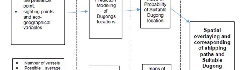
Research Approach
This research undertakes several mathematical and statistical analyses of vessel transportation
that focus on air quality related to the main marine animal of Strait (Dugong), using a
visualization platform (GIS). The distance from the maritime paths to the dugong home range is
calculated based on shipping emissions (Escourroug, 1996) from moving vessels in the Strait.
The research method includes four main steps. At first, a new model is developed concerning air
pollution threshold, shipping, and the Dugong home range. Next, the model is applied with
generalized values for the components of the shipping system and weather conditions to fit the
region of the study. To implement the third step, the elements of a transportation network
database are used to design a suitable maritime transportation path. Finally, spatial analyses of
maps are performed to determine the adaptability of marine routes with considerations for dugong
home range and air pollution. These steps, which are useful for modeling suitable maritime paths,
will be explained as follows. Various factors with different influence levels and importance
degrees were established as criteria as shown in figure1.
Figure 1: Various factors and different influence levels in the research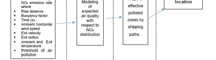
67| Journal of Wildlife and Biodiversity 5 (1): 63-80 (2021)

As shown in figure 1, the most output of this research is analyzing and corresponding of hs and
Suitable Dugong locations The role of factors (levels 1, 2, and 3) will be clarified in the
methodology, and the main output (level 4) will be clarified and discussed in the results and
conclusion.

Habitat modeling
The Maximum Entropy modeling approach was used to predict the areas with high presence
potential based on the maximum entropy algorithm. This modeling approach performs better than
other presence-only modeling approaches such as Ecological niche Factor Analysis (ENFA) and
DOMAIN. Meanwhile, this modeling method acts better than GLM/GAMs modeling methods by
its generative approach, especially when the location data are incomplete (Hernandez et al. 2006,
Gastón & García-Viñas, 2011). Both continuous and categorical variables can be used in this
modeling approach (Baldwin 2009). The maximum entropy algorithm that is based on machine
learning response estimates the most uniform distribution (maximum entropy) of sampling points
compared to background locations given the constraints derived from the data (Rudrapati &Arun,
2019; Phillips et al., 2004). This deterministic algorithm can be covered to the maximum entropy
probability distribution (Phillips et al., 2009). So the resulting outputs represent how much better
the model fits the location data than a uniform distribution (Phillips et al., 2004, 2009, Elith et al.,
2011). To better use the small sample size of the species, we use the replication function in
MaxEnt to randomly sample occurrences for training runs and use the remaining circumstances to
test the model. Specifically, we performed ten replications using the cross-validation procedure in
MaxEnt 3.3.3. Using all of the data for model performing and validation, cross-validation is
preferable compared to using a single training/test split in the dataset, thus making better use of
small datasets (Hernandez et al., 2006).

Representation of Models Ability
We used receiving operator characteristic (ROC) curve to represent models ability to predict
species locations and absences by plotting sensitivity (true positive) against 1– specificity (false
positive) (Caetano & Silva Jota, 2016; Phillips et al., 2006) and derived AUC statistic was used as
a threshold-independent measure of the overall fit of the model. An optimal model, one that
predicted each occurrence of a species and for which each prediction was accurate, would have an
AUC of 1.0, while a model that predicted species occurrences at random would have an AUC of
0.5 (Phillips et al., 2006).

Variables
Two sets of data were used in the modeling process, including dugongs' sighting points and eco-
geographical variables including distance to the nearest coastal line, water mean depth, the
presence of any floating vessels close to the presence point. Dugong sightings were collected as
in line transects using ferries and boats. Totally 114 dugong sightings points were recorded
during the study period. Sightings data also were accessed based on fisher interviews and
community monitoring programs conducted by other regional projects (Marsh et al., 2010) and
the MarineResearch Foundation. High-resolution seagrass distributions have been mapped in
Australia (e.g. the Great Barrier Reef) (Grech & Coles, 2010) and the Mediterranean Sea
(Pasqualini et al., 2005); however, current seagrass data sets are incongruent and spatially
68| Journal of Wildlife and Biodiversity 5 (1): 63-80 (2021)

restrictive for Malaysia. Depth, coastal proximity, and solar accessibility and intensity are all
factors in seagrass growth and productivity, including two dominant seagrass species favored by
dugongs: Halodule uninervis and Halophila ovalis (De Iongh et al., 2007). Several proxy
parameters that are known to be favorable for seagrass growth, and thus dugong foraging
including depth (m), distance from the coast, seafloor slope, solar radiation, were used to assess
the plant species distribution mapping. Arc-second global bathymetry data were accessed from
the Oceans' General Bathymetric Chart (GEBCO, 2014). To maximize variation related to slope
aspect, total solar radiation was calculated for the late afternoon during the winter solstice
(Austin, 2002). The coast's distance was calculated in ArcGIS (version.10.1) as the Euclidean
distance from an individual raster cell center to the coast.

Shipping Air Pollution Modeling
Modeling expected air quality regarding NOx distribution is done using the basic theory of the
primary standard of pollutants in eight hours (WHO, 2000). The threshold of air pollution for
Dugong health in Malaysia is considered 10 mg /m3.
The modeling method's basic theory is the maximum ground level concentration of NO x,
considering the spread of a plume in vertical and horizontal directions. In this basic theory, a
plume is assumed to occur by simple diffusion along the mean wind direction. Like other
pollutants, NOx accumulation is done based on stability time, independently or in conjunction
with atmospheric temperature, wind speed, curb length, atmospheric pressure, and area. The curb
length of NOx, as an indicator of a suitable distance from Dugongs home range, is a function of
the plume rise of NOx, average atmospheric pressure and temperature, average estimated stack
diameter, average stack exiting velocity, average wind speed, and type of marine vehicle)
Matthias et al., 2010). This function is restructured for the Melacca Strait to plan shipping Paths.
The basis of the mathematical trajectory is the combination of several relative formulas and
models to calibrate a new model concerning the problem. The mathematical trajectory steps are
summarized in this section, assuming that the optimum Euclidean distance (Dmin) from vessels is
defined based on good air quality. The elements to be constructed in the model are listed as the
indicator of good air quality for Dugong, the role of marine transportation in the production of air
pollution, and the acceptable distance between vessels and the wildlife habitats to meet the goal
of good air quality. The modeling aims to determine the main variables of these elements.

Element Description
Several pollutants are emitted by vessels, but statistics on air pollution emissions attributed to
maritime transportation show that the main contribution is NOx (Escourroug, 1996). In this paper,
NOx is considered the air pollution indicator of maritime transportation. Practical information
(MDM, 2015) shows that the average passing time of vessels through Malacca strait length is
approximately 6 hours; thus, 6 hours is considered the model's passing time. Based on this
consideration, the concentration level of air pollution for animals of seaside areas' health (30
mg/m3 for 6 hours) is an indicator of acceptable air quality for Dugong (WHO, 2005).
With respect to the above explanation, the minimum safe distance between the shipping route and
the Dugong habitat to avoid the emitted air pollution of marine vehicles (Dmin) is the distance in
which the total NOx emission rate of vessels is reduced to 30 mg/m3, the known acceptable
concentration level of NOx for health (WHO, 2005). This safe distance depends on a plume in the
69| Journal of Wildlife and Biodiversity 5 (1): 63-80 (2021)
vertical and horizontal directions and is assumed to occur by simple diffusion along the direction
of the mean wind, and takes into account the total NOx emission rate of vehicles as expressed in
Equation (1), developed by Turner (1995):
1
Q H Y
Cx e1/2 e1/2 (1)
y zU
z y .
Cx= Ground level concentration at some distance x downwind (g/m3),
Q= Average emission rate (g/sec),
σy= Standard deviation of wind direction in the horizontal (m),
σz= Standard deviation of wind direction in the vertical (m),
U= Mean wind speed (m/sec),
e= Natural log (equal to 2.71828),
H= Effective stack height (m), and
Y= Off-centerline distance (m).
To calculate this distance, the following information is required: total NOx emission rate of
vehicles, rise distance of emitted NOx, mean wind speed, and standard deviation of vertical and
horizontal wind direction.
NOx pollution is highly sensitive. To calculate the total NO x emission rate of vessels, it is best to
consider the total number of vessels passed through straight, as expressed in Equation 2:
Q ivi q i (2)
,
where
Q = Total NOx emission rate of vessels passed through straight,
vi = Number of vessels of type i passed through straight, and
qi = Possible average NOx emission rate for one vessel of type i during passing time.
The vessel type and passing time are considered for computing qi. To calculate the rise distance
of emitted NOx bypassed straight vessels (Δh), these equations, developed by Wayson (2000), can
be used:
1/ 3
F0 t 2 (3)
h 1.6
U ,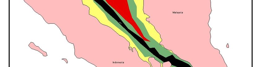
70| Journal of Wildlife and Biodiversity 5 (1): 63-80 (2021)
T
F0 gvs rs 2 1 a (4)
wh
Ts , ere
Δh
= Rise distance (m),
F0 = Buoyancy factor (m4/s3),
t = Time (s),
U = Ambient horizontal wind speed (m/s),
g = Gravitational constant = 9.81 m/s2,
vs = Exit velocity (m/s),
rs = Exit radius (m),
Ta = Ambient temperature (K) and
Ts = Exit temperature (K).
The parameters of Equations 2, 3, and 4 can easily be obtained through annual reports of the
region of study and actual measurements concerning vessel type (bulk), standards, and guidelines.
Time is stability time of NOx equal to 15 minutes or 900s (Gulam et al., 2013). The average
Passed straight vessels number in this time is about 40 vessels
Vertical and horizontal dispersion (σy and σz) can be found in the attributes in Table 1.
Finalization of the Model
By applying the amount of Cx = 0.03g/m3 (primary standard of NOx pollutant in 6 hours),
Equation (1) can be rewritten as follows:
3 Q h 2
z y 6.8 (5)
U
Δh and Q are obtained by Equations 2 and 3, but where is D min? In Equation 6, σy and σz are
replaced by a mathematical function of D min:
z 3 y F ( Dmin ) (6)
Therefore, based on Equation 6 and 5,
Q h 2 (7)
F ( Dmin ) 6.8
U
Weather Stability Classes are expressed in 6 situation (A,B,C,D,E and F) based on 3 main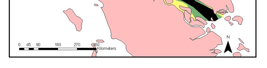
71| Journal of Wildlife and Biodiversity 5 (1): 63-80 (2021)
parameters: Incoming solar radiation, thinly overcast, and wind speed (Table 1)
Therefore, it is necessary to develop F(Dmin). Because most vessels are passed through Strait
during the day (MDM, 2015), the factor of thinly overcast skies as a weather indicator for the
night (Table 1) is ignored.
Table 1: Key to Weather Stability Classes
Day Night
Incoming Thinly
Wind Solar Radiation Overcast
Speed Strong Moderate Slight More than Less than
(m/s) 50 % Cloud 50 % Cloud
Less than 2 A A-B B E F
2-3 A-B B C E F
3-5 B B-C C D E
5-6 C C-D D D D
More than 6 C D D D D
Source: Turner, 1995
Solar radiation and average wind speed in the study area play prominent roles in this process.
Based on historical data (Annual Climate Assessment Reports, 2014) and table 1, the study area
is similar to the situation (C). Thus, this situation (C) was used to develop F(Dmin). Crowl and
Louvar (2002) developed the following equations for the situation (C):
y 0.22 D (1 0.0004)
, Be
(8)
cau
z 0.20 D (9)
se
the
numerical values of 0.0004 Dmin given in Equations 8 and 9 are extremely small, they can be
eliminated. Based on Equation 6,
F Dmin 0.22Dmin 0.2Dmin (12)
3
Then,
F Dmin 0.0021Dmin .
4 (13)
Then, based on Equations 8 and 14,
6.8h 2Q (14)
0.0021Dmin 4
U
The final model can be rewritten as follows: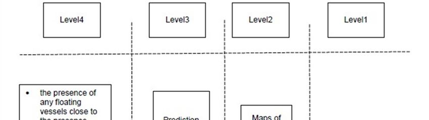
72| Journal of Wildlife and Biodiversity 5 (1): 63-80 (2021)
(15)
h1/ 2Q1/ 4
Dmin 7.54
U 1/ 4 .
Evaluation of the Model
During the sensitivity analysis process, the effects of three main variables (Δh, Q, and U) on
calculated and field Dmin were compared to test the accuracy and ability of the model. It was done
to determine which of these three variables are critical and significantly affect the model outputs.
The mathematical relationship of model parameters shows the non-acceptable level of accuracy in
most of the samples. more concentration of errors in higher values of Q. It means more sensitivity
of the model is relative to Q and its parameters. Also, Q's parameter is flexible and controllable,
which can be changed to achieve more accuracy through NOx's stability period. The peak value
of NOx concentration (5 minutes) decreasing emitted NOx is done very fast. So, the maximum
stability period of NOx (15 minutes) is not a good indicator of transport air pollution. It is better
to make an average time between the peak value and maximum stability time (10 minutes). The
result shows the minimum errors in the application of the grid size equal to 25 m and stability
time equal to 10 minutes (Fig. 2).
60
50
40
Error (%)
30
20
10
0
1 7 13 19 25 31 37 43 49 55 61 67 73 79 85 91
Sampling Numbers
Figure 2: Mathematical Errors of Field Dmin after Calibration of Stability Time
Validation is done to evaluate model accuracy. It assesses whether the model is working as
intended. The model validation is done by comparing its predictions with field data. If the
differences between field prediction and field data are small, then the proposed model is accurate.
Concerning basic knowledge of sensitivity analysis, this process (validation) is done by applying
values of parameters of calculated Dmin and field Dmin and analyzing them two parameters'
mathematical relationship
Testing of the Model is to create a practical test (derived from an implementation) to verify the
model. For example, if the calculated minimum safe distance for one station was more than the73| Journal of Wildlife and Biodiversity 5 (1): 63-80 (2021)
actual distance, the sensors monitored some pollution in this station. Also, if the calculated
distance was less than the field distance, there should not be any pollution. Also, testing results,
which have been done, show 82.9 % of the cases coincided in the observations confirming the
model's ability and usefulness (Fig. 3).
Coincident Cases
Not-Coincident Cases
Figure 3: Results of Model Testing
Contribution of the Model for Malacca Strait
After performing a sensitivity analysis, calibration, testing, and validation of the model in the
study area, the model was applied with the generalized values for the components of the shipping
system and weather condition and was found to fit the study area. Since more than 95% of passed
vessel types in the study area include bulk type (MDM, 2015), our calculation is done by
considering this type and fuel consumption (Williams et al., 2006), equal to about 80 tons per
day.
Concerning the average rate of NOX in marine fuel consumption and summarizing the number of
passing vessels, the main data constants used are the following:
a) Ts (General average exiting gas temperature from exhaust) = 395K,
b) Ta (Average annual atmospheric temperature for study area) = 293K,
c) P (Average annual atmospheric pressure for study area) =1000 mB,
d) t ( duration time for calculation) = 600s
After applying these generalized values in the model, the D min was calculated for shipping paths
equal to 1655m.
Determination of Probability of Suitable Dugong Habitat Conditions
Figure 1 shows the modeled probability of suitable habitat conditions based on dugong presence
data. The MaxEnt model predicted the most suitable dugong habitat in the Malacca Strait. We
obtained 114 sites for the Dugongs to develop a distribution model. The average result derived
from 10 replication runs by the model is presented in figure 4. The species' potential distribution
map indicated that 23.36% of the whole study area occurred in areas with the highest suitability
value (0.6 to 1). When the binary output is preferred (e.g., habitat vs. non-habitat), the threshold74| Journal of Wildlife and Biodiversity 5 (1): 63-80 (2021)
value to reclassify continuous suitability map to suitable/unsuitable becomes critical, and further
research is required to establish rules for choosing optimal thresholds to distinguish suitable areas
from unsuitable ones. Threshold independent tests of the model indicated that the model
performed well in predicting D. dugong distribution. The mean AUC value for the cross-validated
model was 0.854, which was considered to offer 'excellent discrimination' given our
interpretation of AUC values. We also found that the standard deviation of AUC values was low
(0.012), indicating some level of uniformity amongst replications. Relative contributions of the
environmental variables to the MaxEnt model revealed that variables included distance to the
coastal line (88.2%), sea bed slope (7%), and the presence of any moving vessel (4.8%). The
averaged area under the curve (AUC) value derived from the 10 replicated MaxEnt models was
0.88 (± 0.04), indicating that the model performed well
.
Figure 4: Probability of Dugong Suitable Habitat Conditions
Spatial overlaying maps for the determination of adaptability
In this research, the pollution evaluation of Dugong Habitat was performed by determining
polluted areas of the seaside. Areas with low air quality were obtained by overlay analysis and
selecting effective polluted zones by Probability of Suitable Dugong Habitat. The categorization
of polluted areas was based on emitted pollution using buffering and dissolving the "spatial75| Journal of Wildlife and Biodiversity 5 (1): 63-80 (2021)
analysis toolbox" in ArcGIS 9.1. These powerful tools can perform various spatial operations on
all types of vector data. The process was performed by overlaying Probability of Suitable Dugong
Habitat maps using the following procedures:
Creating maps of effective polluted zones by shipping paths.
Overlaying maps of Probability of Suitable Dugong Habitat and polluted zones.
Results
The results took into consideration the main negative environmental elements in shipping paths.
Based on environmental guidelines, there is no air pollution danger for dugongs' health. These
guidelines ensure that the seaside is located a safe distance away from shipping paths. The
minimum calculated distance serves as a constraint to indicate where the dugongs' habitats cannot
be located. The result is that too many parts of the probability of suitable Dugong habitat in the
study area do not have a proper position that does not put it in conflict with shipping polluted
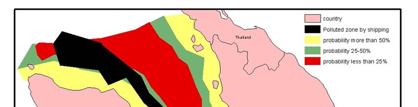
zones (Fig. 5).
Figure 5: Position of Probability of Dugong Habitat in Conflict with Shipping Polluted Zones
The results (Figure 4) show 3 dangerous situations levels for shipping pollution by controlling
implementation and isolation of Dugong Habitat in the study area:
1- Very dangerous: interaction of shipping pollution area with high (more than 50%)
Probability of Suitable Dugong Habitat
2- Dangerous: interaction of shipping pollution area with moderate (25 - 50%) Probability of
Suitable Dugong Habitat
3- No dangerous: interaction of shipping pollution area with low (less than 25%) Probability76| Journal of Wildlife and Biodiversity 5 (1): 63-80 (2021)
of Suitable Dugong Habitat
With regard to the above categories, the shipping path of the Strait can be divided into three
geographical parts (Figure 6 and Table 2):
Figure 6: Categorizing of Shipping Pollution for Dugong Habitat Controlling Implementation
Table2: Situation of Polluted Zones and Probability of Suitable Dugong Habitat in 3 Shipping Path Parts
Part 1 2 3
Including Polluted zone Very dangerous dangerous Very dangerous
dangerous dangerous
No dangerous
Including Probability of Suitable Low Low Moderate
Dugong Habitat Moderate Moderate High
High High
Since the more suitable shipping path should be located in lower Probability of Suitable Dugong
Habitat, with respect to the criteria and considerations of shipping path designation, there are
similar types of spatial conditions. Low Probability of Suitable Dugong Habitat have higher
preferences for designation, and high Probability of Suitable Dugong Habitat require improvement
and re-designation. There are several options to improve the currently unsuitable shipping paths,
which can be investigated through the following scenarios:
Removing all unsuitable shipping paths and designing new shipping paths in Low
Probability of Suitable Dugong Habitat,
Changing vessel types and number to provide smaller strait shipping paths77| Journal of Wildlife and Biodiversity 5 (1): 63-80 (2021)
Shifting some unsuitable shipping paths to low and moderate probability of suitable
Dugong habitat,
With respect to economic and technical possibilities, the first scenario cannot be accepted for
study area, furthermore, in part 3 of strait shipping paths, there is no low probability of suitable
Dugong habitat.
The second scenario can be discussed. Changing vessel types with respect to the economic
importance of Malacca strait for petrol bulk carrier transits is impossible, but the numbers and
traffic of vessels can be changed via controlling by taxes. Different daily taxes can help distribute
vessel traffic during more and varied times (days or nights).
Shifting unsuitably shipping paths to low and moderate probability of suitable Dugong habitat is
the most reasonable scenario. Concerning economic and technical limitations and also mentioned
the breeding cycle of Dugong, this scenario can give us several spatial and seasonal options. With
regard to the categorized shipping pollution for Dugong habitat, further preferences should be
considered based on ecological, economic, and technical limitations. The following suggestions
may help to improve shipping paths:
Removing very dangerous zone (Figure3) via shifting parts 1 and 2 of the path to the low
probability of suitable Dugong habitat at especial Dugongs breeding season (September-
November).
Shifting parts 1 and 2 of the path to moderate probability of suitable Dugong habitat at all
year except especial Dugongs breeding season (September-November).
More limitation in vessel numbers and transportation time via taxes and port police and
maritime police, particularly in part 3 of the path.
Conclusion
This research has successfully managed and developed a scientifically based method for
understanding the relationship between wildlife habitat and marine transportation by analyzing
successful and non-successful present and future shipping. As discussed in the results, successful
shipping will be achieved when the shipping path is located in a lower probability of suitable
Dugong habitats. It means polluted areas by shipping paths should not have spatial interaction
with a high probability of suitable Dugong habitats. This issue has been analyzed by zoning and
exploring shipping paths concerning Dugongs' habitats. The research strategy can support
maritime planners with a range of options. However, with selecting the best or most suitable
routes, an experimental approach can be developed. The primary purpose of this experimental
approach will be to choose the shipping path from among the alternatives. Implementation of the
method and scenario analysis suggests that some areas are more suitable than others for shipping
path if the performance (Dugong's health and air quality) and criteria (shipping paths and the
probability of suitable Dugong habitats) are considered carefully. The suitability of the shipping
path largely depends on the goals of the marine transportation, but the importance of the two main
performances (Dugong's health and air quality) cannot be ignored in any marine transportation
project.
By developing and implementing the mentioned methods in the study area, it is possible to
illustrate the implementation of a spatial strategy in maritime transportation planning to explain
the linkage between wildlife protection and air quality for the better design of shipping paths. This
approach can help planners to determine potential locations for shipping paths. The method78| Journal of Wildlife and Biodiversity 5 (1): 63-80 (2021)
presented in this study is not intended for the exact site selection of polluted areas and shipping
paths. This method includes a generalized spatial tool. This spatial tool can help decision-makers
to design better shipping path. This tool can also assist maritime planners by providing a list of
alternatives and their advantages and disadvantages within marine transportation policies and
projects. In this way, planners can offer a maximum amount of marine transportation at the lowest
economic and environmental investment cost.
Acknowledgment
We wish to acknowledge the Institute for Environment and Development (Grant no : XX-15-2012,
Upscaling of MSMA Stormwater Ecohydrology at Catchment Level in Sg. Langat), UKM,
Malaysia, to provide resources and collaborative efforts.
References
Adulyanukosol, K., Thongsukdee, S., Hara, T., Arai, N., Tsuchiya, M. (2007). Observations of
Dugong reproductive behaviour in Trang Province, Thailand: further evidence of
intraspecific variation in dugong behavior. Marine Biology. 151(5), 1887-1891.
DOI: 10.1007/s00227-007-0619-y
Anderson, P. (1997) Shark Bay dugongs in summer, I: Lek mating. Behaviour. 134(5/6), 433-462.
DOI: https://www.jstor.org/stable/4535450
Annual Climate Assessment Reports (2014) Singapore Metrological Service, 5-16
Austin, M.P. (2002) Spatial prediction of species distribution: an interface between ecological
theory and statistical modeling. Ecol. Model. 157, 101–118.DOI:
https://doi.org/10.1016/S0304-3800(02)00205-3
Baldwin, R.A (2009) Use of Maximum Entropy Modeling in Wildlife Research. Entropy. 11,
854–866. DOI: https://doi.org/10.3390/e11040854
Briscoe, D., Hiatt, S., Lewison, R., Hines, E. (2014) Modeling habitat and bycatch risk for
dugongs in Sabah, Malaysia ENDANGERED SPECIES RESEARCH. 24, 237–247.
DOI: 10.3354/esr00600
Burgess, E. A., Lanyon, J.M., and Keeley, T. (2012) Testosterone and tusks: maturation and
seasonal reproductive patterns of live, free-ranging male dugongs (Dugong dugon) in a
subtropical population. Reproduction, 143, pp 683–697 .doi: 10.1530/REP-11-
0434. Epub 2012 Mar 5.
Caetano, W.D., da Silva Jota, P. (2016) Load Static Models for Conservation Voltage Reduction
in the Presence of Harmonics. Energy and Power Engineering. 8(2), 62-75.
DOI: 10.4236/epe.2016.82006.
Crowl, A. D., and Louvar, J. F. (2002) Chemical Process Safety. Prentice Hall PTR, USA. 186-
236
De Iongh, H., Kiswara, W. Kustiawan,W., Loth, P. (2007) A review of research on the
interactions between dugongs (Dugong dugon Muller 1776) and intertidal seagrass beds
in Indonesia. Hydrobiologia. 591, 73-83. DOI 10.7717/peerj.2194
Elith, J., Phillips, S.J., Hastie, T., Dudík, M., Chee, Y.E., Yates, C.J. (2011) A statistical
explanation of MaxEnt for ecologists. Diver. Distrib. 17,43–57.DOI:
https://doi.org/10.1111/j.1472-4642.2010.00725.x79| Journal of Wildlife and Biodiversity 5 (1): 63-80 (2021)
Escourroug (1996) Transport, contraintes climatiques et pollution. Sedes.
Gastón, A., García-Viñas, J.I. (2011) Modeling species distributions with penalized logistic
regressions: A comparison with maximum entropy models. Ecol. Model. 222, 2037–
2041. DOI: 10.1016/j.ecolmodel.2011.04.015
GEBCO (General Bathymetric Chart of the Oceans) (2014) https://www.gebco.net
Grech, A. & G.Coles (2010) An ecosystem-scale predictive model of coastal seagrass distribution.
AQUATIC CONSERVATION: MARINE AND FRESHWATER ECOSYSTEMS. 20,
437–444. https://doi.org/10.1002/aqc.1107
Gulam, M., Alka, A., Sanjula, B., And Javed, A. (2013) Box-Behnken supported validation of
stability-indicating high performance thin-layer chromatography (HPTLC) method: An
application in degradation kinetic profiling of ropinirole. Saudi Pharmaceutical Journal.
21(1), 93-102. DOI: https://doi.org/10.1016/j.jsps.2011.11.006
Hernandez, P.A., Graham, C.H., Master, L.L., Albert, D.L. (2006) The effect of sample size and
species characteristics on performance of different species distribution modeling
methods. Ecography. 29, 773–785. DOI:
https://doi.org/10.1111/j.0906-7590.2006.04700.x
Ilangakoon, A., Tun, T. (2007) Rediscovering the Dugong in Myanmar and capacity building for
research and conservation. The Raffles Bulletin of Zoology. 55(1), 195-199. DOI:
https://www.researchgate.net/publication/228661505
Lawler, I., Marsh, H. McDonald, B. and Stokes, T. (2002) Dugongs in the Great Barrier Reef:
Current state of knowledge. Cooperative Research Centre for the Great Barrier Reef
World Heritage Area .CRC Reef Research Centre Report.
Lefebvre, L., Reid, J. Kenworthy, W. Powell, J. (2000) Characterizing manatee habitat use and
seagrass grazing in Florida and Puerto Rico:implications for conservation and
management. Pac Conserv Biol 5, 289−298. DOI: 10.3354/meps11986
Marsh, H. and Sobtzick, S. (2015) Dugong dugon. The IUCN Red List of Threatened
Species 2015.
Marsh, H. (2002) Dugong: Status Report and Action Plans for Countries and Territories. UNEP
Marsh, H., Heinsohn, G. Marsh, L. (2010) Breeding cycle, life history, and population dynamics
of the Dugong, Dugong dugon (Sirenia: Dugongidae). Australian Journal of Zoology,
32(6), 767-788. DOI: 10.1071/ZO9840767
Matthias. V, Bewersdorff, I. Aulinger, A. and Quante, M. (2010) The contribution of ship
emissions to air pollution in the North Sea regions. Environmental pollution. 158, 2241-
2250. https://doi.org/10.1016/j.envpol.2010.02.013
MDM (Marine Department of Malaysia) (2015) Official website, List of statistic, available in
http://www.marine.gov.my
Miola, A. and Ciuffo, M. (2011) Estimating air emissions from ship: Meta-analysis of modelling
approaches and available data sources. 5, 2242-2251.
DOI: 10.1016/j.atmosenv.2011.01.046
Pasqualini, V., Pergent-Martini, C., Fernandez,C., Ferrat, L., Tomaszewski, J. and Pergent, G.
(2005) Wetland monitoring: aquatic plant changes in two Corsican coastal lagoons
(Western Mediterranean Sea), AQUATIC CONSERVATION: MARINE AND
FRESHWATER ECOSYSTEMS.16(1) , 43-60. https://hal.archives-ouvertes.fr/hal-
0176910980| Journal of Wildlife and Biodiversity 5 (1): 63-80 (2021)
Phillips, S.J., Dudík, M., Schapire, R.E. (2009) MaxEnt software for species habitat modeling,
version 3.3.1. Available online
Phillips, S.J., Dudík, M., Schapire, R.E. (2004) A maximum entropy approach to species
distribution modeling (In: Proceeding of 21st International Conference on Machine
Learning) . ACM Press: New York, NY, USA. 655–662.
Rudrapati, R. and Patil, A. (2019). Optimization of Cutting Conditions for Surface Roughness in
VMC 5-Axis. Materials Science Forum. 969, 631-636. DOI:
10.4028/www.scientific.net/MSF.
Saxe, H. and Larsen, T. (2004) Air Pollution from Ships in three Danish ports. Atmospheric
Environment. 38, 4057-4067. DOI: https://doi.org/10.1016/j.atmosenv.2004.03.055
Solvay, G., Hans-Dieter, E. and Anna-Katharina, H. (2008) The Straits of Malacca: knowledge
and diversity. Lit; London: Global [distributor], Berlin, 23-113
Turner, D. B. (1995) Atmospheric Dispersion Estimates, an Introduction to Dispersion Modeling.
Lewis Publisher, USA.
Wayson, R. (2000) Predicting Air Quality near Roadways through the Application of a Gaussian
Puff Model to Moving Sources. Proceeding of 93rd Annual Conference and Exhibition of
the Air and Waste Management Association, USA.
WHO (2005) Air Quality Guidelines. Regional Office for Europe, Copenhagen, Denmark, 15-17
Williams, E. J., Lerner, B. M., Murphy, P. C. Herndon, S. C. (2006) Emissions of NOx, SO2, CO,
and HCHO from commercial marine shipping during Texas Air Quality Study
(TexAQS), Journal of Geographic Research, 114(21), 1984–2012.
https://doi.org/10.1029/2009JD012094You can also read