Global Distribution of Coral Reefs - UNEP-WCMC
←
→
Page content transcription
If your browser does not render page correctly, please read the page content below
Dataset ID: WCMC-008
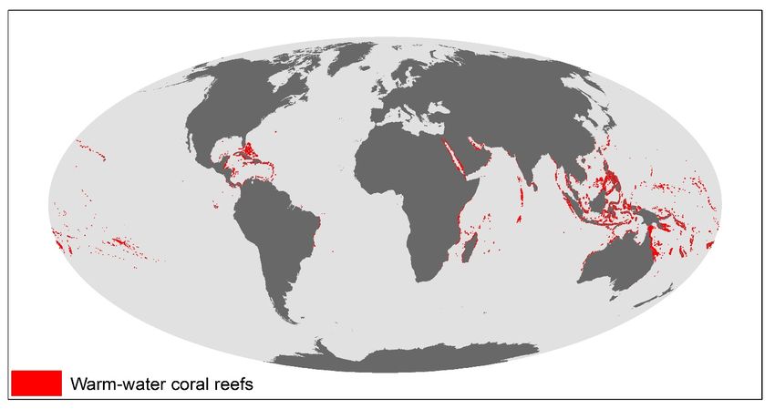
Global Distribution of Coral Reefs
Description: This dataset shows the global distribution of coral reefs in tropical and
subtropical regions. It is the most comprehensive global dataset of
warm-water coral reefs to date, acting as a foundation baseline map for
future, more detailed, work. This dataset was compiled from a number
of sources by UNEP World Conservation Monitoring Centre (UNEP-
WCMC) and the WorldFish Centre, in collaboration with WRI (World
Resources Institute) and TNC (The Nature Conservancy). Data sources
include the Millennium Coral Reef Mapping Project (IMaRS-USF and IRD
2005, IMaRS-USF 2005) and the World Atlas of Coral Reefs (Spalding et
al. 2001).
Citation: UNEP-WCMC, WorldFish Centre, WRI, TNC (2021). Global distribution of
coral reefs, compiled from multiple sources including the Millennium
Coral Reef Mapping Project. Version 4.1, updated by UNEP-WCMC.
Includes contributions from IMaRS-USF and IRD (2005), IMaRS-USF
(2005) and Spalding et al. (2001). Cambridge (UK): UN Environment
Programme World Conservation Monitoring Centre. Data DOI:
https://doi.org/10.34892/t2wk-5t34
For further information on the Millennium Coral Reef Mapping Project,
see:
Andréfouët S, Muller-Karger FE, Robinson JA, Kranenburg CJ, Torres-
Pulliza D, Spraggins SA, Murch B. (2006). Global assessment of modern
coral reef extent and diversity for regional science and management
applications: a view from space. Proceedings of 10th International Coral
Reef Symposium: 1732-1745.
Citations for the separate entities:
IMaRS-USF (Institute for Marine Remote Sensing-University of South
Florida) (2005). Millennium Coral Reef Mapping Project. Unvalidated
maps. These maps are unendorsed by IRD, but were further interpreted by
UN Environment Programme World Conservation Monitoring Centre
http://wcmc.io/MarineDataManual
Page | 1Dataset ID: WCMC-008
UNEP World Conservation Monitoring Centre. Cambridge (UK): UNEP
World Conservation Monitoring Centre.
IMaRS-USF, IRD (Institut de Recherche pour le Developpement) (2005).
Millennium Coral Reef Mapping Project. Validated maps. Cambridge (UK):
UNEP World Conservation Monitoring Centre.
Spalding MD, Ravilious C, Green EP (2001). World Atlas of Coral Reefs.
Berkeley (California, USA): The University of California Press. 436 pp. URL:
https://archive.org/details/worldatlasofcora01spal
A form of this dataset was used in the following publication:
Burke L, Reytar K, Spalding M, Perry A. (2011). Reefs at Risk Revisited.
Washington, DC: World Resources Institute. 115 pp. URL:
http://www.wri.org/publication/reefs-risk-revisited
Data collection date: 1954-2009
Geographic range: Global
Supplementary Attribute table: Automatically generated number (OBJECTID); Unique ID
information: distinguishing the data entry (LAYER_ID); Metadata ID linking to the
source of the dataset, found in the associated metadata table
(METADATA_ID); English name of the feature as provided by the data
provider (NAME); Name of the feature as provided by the data provider in
original language (ORIG_NAME); Local definition of feature as provided by
the data provider (LOC_DEF); Scientific (Latin) name(s) of family, genus
and species (FAMILY, GENUS, SPECIES); Reported area in square
kilometres (REP_AREA_KM2); Area calculated using GIS, in square
kilometres (GIS_AREA_KM2); description of whether data have been
obtained through remote sensing and/or field survey (DATA_TYPE); data
gathering approach (SURVEY_MET); start and end date of data collection
(of survey), supplied as text in the format YYYY-MM-DD (ISO date format)
(START_DATE, END_DATE); character code that identifies accuracy of
dates used in START_DATE and END_DATE to the nearest day(s),
month(s), or year(s) (DATE_TYPE); Minimum/maximum depth in metres
that the feature was found (MIN_DEPTH and MAX_DEPTH); verification
by government or expert (VERIF).
Purpose of creation: IMaRS-USF was funded by the Oceanography Program of NASA (National
Aeronautics and Space Administration) to provide an exhaustive worlwide
inventory of coral reefs using high-resolution satellite imagery, under the
framework of the Millenium Coral Reef Mapping Project (Andréfouët et al.
2006). As a fully validated Millennium Coral Reef Mapping Project product
was not available at the global scale, there was a need to create an
'interim' global amalgamated map product. The dataset was hence
created to further mobilise the Millennium Coral Reef Mapping Project
products and their validation.
Creation methodology: Approximately 85% of this dataset originates from the Millennium Coral
Reef Mapping Project, of which 35% was validated (by IMaRS-USF and
IRD-Noumea) and 50% remains unvalidated (but was interpreted by
UNEP-WCMC). Millennium Coral Reef Mapping Project products
(validated or not) are at a consistent 30 m resolution (multispectral
Landsat 7 images acquired between 1999 and 2002,
http://www.imars.usf.edu/MC/index.html). Additional information
regarding methodology and 'validated' and 'unvalidated' polygons can be
UN Environment Programme World Conservation Monitoring Centre
http://wcmc.io/MarineDataManual
Page | 2Dataset ID: WCMC-008
obtained from
http://oceancolor.gsfc.nasa.gov/LANDSAT/HTML/README.html
Where there were no Millennium Coral Reef Mapping Project products,
data (representing the remaining 15%) were compiled from other sources
by UNEP-WCMC. These sources include data from the World Atlas of
Coral Reefs (Spalding et al. 2001) and coral reef maps reproduced with
permission from the Controller of Her Majesty’s Stationery Office and the
UK Hydrographic Office (www.ukho.gov.uk) © British Crown Copyright
and/or database rights. The dataset is mostly fitted to ESRI’s base layer.
Version: 4.1 (March 2021)
Data lineage: Version 4.1 (March 2021):
PARENT_ISO and ISO3 (ISO 3166-3 character code of country or territory
where the feature is located) and SUB_LOC (ISO 3166-2 sub-national
code) were removed. The fields PROTECT (binomial value indicating
whether the feature occurs in an area protected), PROTECT_FEAT
(feature protected by law or by any other conservation measures) and
PROTECT_STAT (measure that protects the feature) were removed.
Version 4 (November 2018):
The dataset was augmented by additional datasets identified through an
extensive literature review.
Version 3 (June 2018):
Geographic attributions (ISO3 and Parent ISO3 codes) of points and
polygons in the datasets have been matched to the World Vector
Shoreline Plus and VLIZ World EEZ v10 geographic layers. This improves
the accuracy of these datasets for national and regional studies. ISO3
codes need to be updated regularly due to codes becoming obsolete or
EEZ boundaries being adjusted. Multipart points and polygons features
were created to reduce the complexity of the attribute tables, merging
those with identical attributes. This reduces the processing power
required to handle the data while maintaining the level of detail required.
The habitat datasets have been quality checked for obsolete ISO3 codes,
overlapping claims identified and "Not Reported" consistently used for
missing values rather than NA or blanks.
Version 2.0 (December 2017):
Standardises the feature and metadata attributes using a new schema,
which aligns the attributes used across the habitat datasets curated by
UNEP-WCMC. The updated attribute schema is outlined in
"Supplementary Information." Specific changes include the addition of
information on level of protection (e.g. PROTECT, PROTECT_FEAT,
PROTECT_STAT), indication of whether the data have received expert or
government verification (VERIF), and information on the start and end
dates of data collection (i.e. START_DATE, END_DATE). The new schema
will be used to inform a set of quality indicators, assessing changes in
data quality over time.
This dataset supersedes the one used in the World Atlas of Coral Reefs
(Spalding et al. 2001), and should by no means replace the official release
of the Millennium Coral Reef Mapping Project. There may be future
updates as better information becomes available and as further
UN Environment Programme World Conservation Monitoring Centre
http://wcmc.io/MarineDataManual
Page | 3Dataset ID: WCMC-008
Millennium Coral Reef Mapping Project products become available.
Changes to the original dataset (ver. 1.0) include:
- Ver. 1.1: Attributes were consolidated in July 2012;
- Ver. 1.2: Duplicate polygons were removed in April 2013;
- Ver. 1.3: further minor-scale corrections (spatial shifts reported by users,
duplicate polygons) were carried out in April 2014, and were updated
online on the 11th February 2015. The total extent (after dissolve) is
150,048 sq km (326,019 polygons).
Category: Biogenic habitat
Keywords: coastal, marine, corals, biogenic
Similar datasets: WCMC-009, WCMC-045, WCMC-001
Limitations: While having global coverage, the dataset was compiled from multiple
sources with varying scale and quality (outlined in
"Metadata_CoralReefs.dbf" included in the package). The dataset has yet
to undergo external review.
The 'validated data' correspond to the final standard of Millennium Coral
Reef Mapping Project products; they can evolve according to minor
corrections and modifications, but no major changes should be expected.
In the 'unvalidated data', boundaries of occurrence polygons are
unchecked and associated attributes are incomplete. In some areas,
unvalidated and validated polygons of differing shapes overlap.
As the dataset may still contain overlapping polygons, a dissolve
operation (within a GIS) might be needed before surface area calculations
are carried out. Most of the dataset's polygons align relatively well
(spatially) to the base layer (coastline) of Open Street Map (used in ESRI
ArcGIS software).
Maintenance Corrections are made on an ad-hoc basis.
frequency:
Main access/use UNEP-WCMC General Data License (excluding WDPA). See
constraint: https://www.unep-wcmc.org/policies/general-data-license-excluding-
wdpa#data_policy for details.
Organisation type: Custodian
Contact Organisation: UN Environment Programme World Conservation Monitoring Centre
City: Cambridge, UK
E-mail: oceanplus@unep-wcmc.org
Data format(s): Vector (polygon); KML Dataset size 1.33 GB
(.kml); WMS; (uncompressed):
Webpage and/or https://doi.org/10.34892/t2wk-5t34
download:
Web map service: http://www.arcgis.com/home/item.html?id=97071c96008d4ea6b0aabe4
ed125661f
Factsheet: http://wcmc.io/warm_coral_reef
UN Environment Programme World Conservation Monitoring Centre
http://wcmc.io/MarineDataManual
Page | 4Dataset ID: WCMC-008
Resolution, scale: Variable Reference system: WGS 1984
West bounding: -180 East bounding: 180
South bounding: -34.3 North bounding: 32.5
Metadata standard: UNEP-WCMC Specific Date of metadata: 26/03/2021
UN Environment Programme World Conservation Monitoring Centre
http://wcmc.io/MarineDataManual
Page | 5You can also read