Griesbach Neighbourhood Area Structure Plan - City of ...
←
→
Page content transcription
If your browser does not render page correctly, please read the page content below
Griesbach
Neighbourhood
Area Structure Plan
 Office Consolidation
      May 2018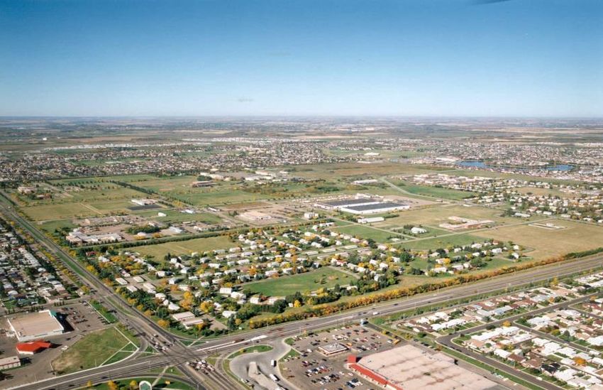
Griesbach Neighbourhood Structure Plan

                                     Office Consolidation July 2021

                                               Prepared by:

                                         Development Services
                                      Urban Planning and Economy
                                           City of Edmonton

Bylaw 12936 (as amended) was adopted by Council in March 2002. In July 2021, this document was
consolidated by virtue of the incorporation of the following bylaws, which were amendments to the
original Bylaw 12936.

Bylaw 12936 Approved March 18, 2002 (to adopt Griesbach NASP)
Bylaw 13192 Approved October 17, 2002 (Incorporate zoning in Section 900 of Zoning Bylaw, Amend
            Chapter 8 of Griesbach NASP)
Bylaw 13565 Approved March 1, 2004 (Expand Aging –in-Place Campus)
Bylaw 14234 Approved March 23, 2006 (Revise Medium Density, Waterway and Parks in south portion of
            NASP)
Bylaw 14531 Approved May 4, 2007 ( Re-designate Low Density Residential uses to Municipal Reserve
            uses and Medium Density Residential uses and reconfigure the north boundary of the Village
            Centre)
Bylaw 14631 Approved July 9, 2007 (Provide development of a linear park and allow for the development
            of a non-standard design of single and semi-detached residential development)
Bylaw 15337 Approved January 20, 2010 (Switch the location of land identified for Low Density
            Residential with Minor Row Housing uses with land identified for School/Recreation uses)
Bylaw 15314 Approved April 28, 2010 (Redesigns the circulation and stormwater management
            system, reconfigures the mixed use residential and the westerly school site, realigns portions
            of the road network, enhances pedestrian links to the central park and redistributes low and
            medium density residential uses in the western area of the Plan.)
Bylaw 17228 Approved June 9, 2015 (Re-designate a portion of Medium Density Residential uses to Local
            Commercial uses to extend the commercial area along Ad Astra Boulevard).
Bylaw 18372 Approved April 23, 2018 (Amended the section “Local Commercial” to include mention of
            anticipated LRT stops)
Bylaw 19226 Approved July 7, 2020 (Amended to allow for freestanding high density development up to
            six storeys immediately south of Griesbach Parade NW in the Village Centre)
Bylaw 19763 Approved July 6, 2021 (Amended a portion of land located in the southwestern corner of
            Griesbach NASP from Mixed Use to Medium Density Residential)

Editor’s Note:

This is an office consolidation edition of the Griesbach Neighbourhood Area Structure Plan, Bylaw 12936, as
approved by City Council on March 18, 2002. This edition contains all subsequent amendments and
additions to Bylaw 12936. For the sake of clarity, new maps and a standardized format were utilized in this
Plan. Where it provides clarity, names of City departments have been standardized to reflect their present
titles. Furthermore, all reasonable attempts were made to accurately reflect the original Bylaws. All text
changes are noted and are gray-scaled and italicized where applicable.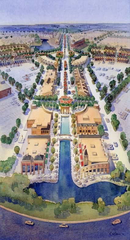
This office consolidation is intended for convenience only. In case of uncertainty, the reader is advised to
consult the original Bylaws, available at the office of the City Clerk.

City of Edmonton
Urban Planning and Economy
Map 1* Griesbach Neighbourhood Area Structure Plan
As amended by Bylaw 19763 Approved July 6, 2021
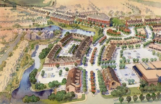
Table of Contents
1. Introduction 1
2. Policy Context 6
3. Site Features 8
4. Planning Principles 13
5. The Plan 15
6. Transportation 23
7. Services 28
8. Implementation 33
9. Statistics 37
10. Appendix 38
List of Figures
1. Location Plan 2
2. Ownership 3
3. Air Photo 9
4. Development Concept 16
5. Transportation Concept 24
6. Stormwater Services 29
Cover Photos clockwise from top
7. Sanitary Services 31
Trooper Griesbach (South African War)
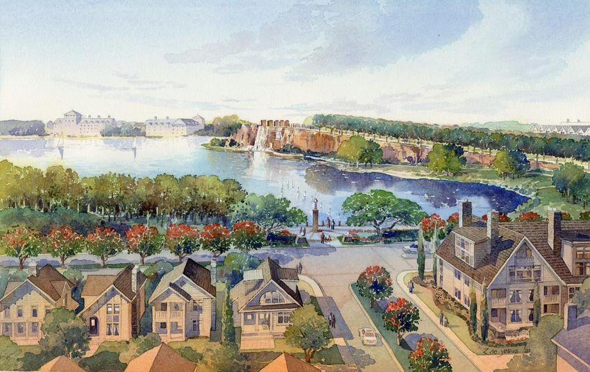
Artist’s concept of village centre 8. Water Services 32
Office building, SW corner, CFB Griesbach
Haas Family at Griesbach, 1960 9. Staging 34
Refurbished PMQ, Garrison Woods, Calgary
10. Tree Overlay 39
11. Existing Buildings 40
12. Environmental 42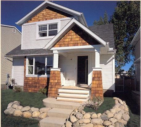
Griesbach NASP Office Consolidation

                                                                           1. Introduction

                                      describes the movement network,
Introduction                          addresses     the   environmental    Ownership
Note: This section was amended        impact, expresses development        Note: This section was amended
by the Editor                         and design guidelines for the        by the Editor
                                      various land uses and their inter-
Developed as a National Defence       relationships, identifies major      The parcels and their current
facility in the 1950s, Canadian       servicing infrastructure, outlines   ownership are shown on Figure
Forces Base Griesbach became          an implementation and staging        2.0:    Ownership.        The
available for new uses because of     sequence,     and    presents    a   Government      of    Canada      is
                                      statistical summary of land use,     finalizing details of the land
the consolidation of armed forces
                                      population, and school students.     transfer process that is to be
activity at Lancaster Park.                                                completed over the next few
                                      This plan is complemented by         months. A Crown Corporation will
On behalf of the developer, a         various supporting documents.        become the new landowner.
Crown      Corporation    Stantec     These include a traffic impact
Consulting     requested      that    assessment,       a   phase    1     There is one minority private land
Edmonton City Council authorize       environmental site assessment, a     owner in the plan area with a
the      preparation     of      a    tree inventory, and an area          small      already      developed
neighbourhood area structure          servicing report.                    commercial     site   that     was
plan for the former CFB                                                    subdivided out of the northwest
Griesbach.     After receiving a                                           corner years ago.
favourable recommendation from        Location
the Planning and Development
                                                                           The      plan     area     contains
Department,       City    Council     The plan area, as shown on           approximately 250 ha (620 acres)
authorized an area structure          Figure 1.0: Location Plan,           consisting of four quarter sections
planning process on January 30,       includes all those lands in north    with    some     road    widenings
2001.                                 Edmonton surrounded by 97            removed from the titles. There is
                                      Street on the east, 137 Avenue       an easement along the edge of
This planning process was to          on the south, Castle Downs Road      97 Street for sewer and telephone
require a realistic level of study    (113A Street) on the west, and       lines.
and analysis; encourage effective     153 Avenue on the north. The
public participation; minimize the    plan area is northwest of the 97     The plan area is a well-defined
time for development approval;        Street/137 Avenue commercial         planning unit of consolidated
foster the orderly, efficient and     node containing Northtown Mall,      ownership   and    independent
economic      development      and    Northwood Mall, and the Rosslyn      character. City Council will be
redevelopment of the site; and        Hotel.                               asked to approve this as a
find the right balance between
                                                                           neighbourhood area structure
certainty and flexibility for a       The surrounding neighbourhoods       plan.
statutory plan to guide long term     include       Evansdale     and
site development.                     Northmount on the east, Rosslyn      The photo above is courtesy of Major
                                      on the south, Carlisle and           (Ret.) David Haas. He is the curator
This plan contains maps and           Caernarvon on the west, and          of the Loyal Edmonton Regiment
narrative that address conformity     Beaumaris on the north. The          Museum. It is a picture he took of
with Plan Edmonton; includes an       Castle Downs Town Centre is          his father, at Griesbach, in 1960.
analysis of existing conditions,      directly north adjacent to Lake
states development objectives,        Beaumaris.

                                                                                                         1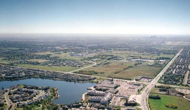
Griesbach NASP Office Consolidation

           Figure 1* Location Plan

           *Bylaw 12936 March 18, 2002

                                         2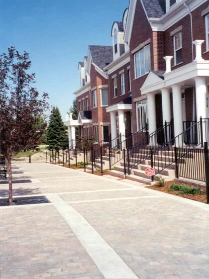
Griesbach NASP Office Consolidation

           Figure 2* Ownership

           *Bylaw 12936 March 18, 2002, as Amended by the Editor

                                                                   3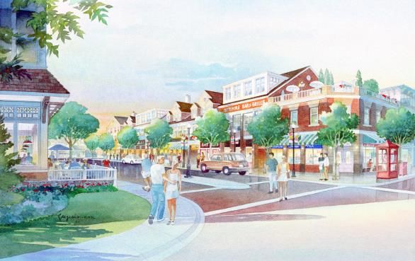
Griesbach NASP Office Consolidation

                                                                            Griesbach,    federal  defence
                                                                            authorities have taken a step
                                      He returned to his law practice,      which will have the immediate
Major General                         which he continued for many           and unanimous approval of the
Griesbach, CB, CMG, DSO,              years, becoming King’s Counsel in     people of Edmonton.
VD, KC                                1918. He became an officer of
                                      the 19th Alberta Dragoons
CFB Griesbach was named after         reserve militia, was sent overseas
Major General William ‘Billy’         as a cavalry officer, then raised
Antrobus Griesbach.                   and     commanded      the     49th
                                      Battalion, Canadian Expeditionary
Born in 1878 at Fort Qu’Appelle in    Force in World War I in which he
what is now Saskatchewan, he          served, until appointed Brigadier
moved to the Edmonton area in         and commanded an infantry
1883 when his father (an original     brigade. He was twice decorated
member of the NWMP) was               for gallantry under fire. He was
transferred to head the Fort          described as a fearless soldier
Saskatchewan detachment. The          and resourceful officer in the
family then moved to Edmonton         thick of much of the heavy
in 1886, when the population of       fighting on the western front.
Edmonton was less than 300.
                                      Major General Griesbach was
He took his early schooling here      elected as Member of Parliament
before going to St. John’s College    for Edmonton West in 1917. He
School in Winnipeg. He returned       was appointed to the Canadian
to Edmonton as a junior articled      Senate in 1921. During World
clerk in a local law office. He was   War II, he was recalled to serve
active in the local athletic          as Inspector General of Western
community and a member of the         Canadian Forces.
local volunteer fire department.
Mr. Griesbach worked at the
Imperial Bank for a while before
completing his law examinations.

Mr. Griesbach served, for two
years, in the South African War as
part of the Canadian Mounted
Rifles.    He was awarded the
Queen’s Medal with four clasps.
Returning to Edmonton in 1901,                                              Photos courtesy of City of Edmonton
he soon became an alderman of         In an editorial in 1951, the          Archives.
the City of Edmonton, then was        Edmonton Journal stated in
elected its youngest mayor, at        deciding to name the huge Army
age 29, in December 1906.             centre north of the city in honour
                                      of    the   late    Major-General

                                                                                                         4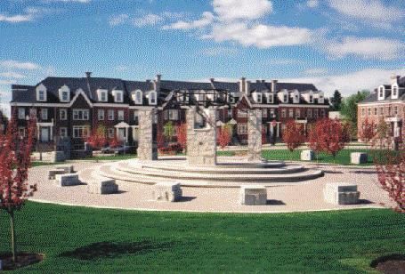
Griesbach NASP Office Consolidation

Inspector General Griesbach died      infrastructure systems.      Being    place throughout the review of
in 1945. As he wrote in his           adjacent to the Northgate Transit     the plan. The plan proponents
autobiography, to recognize the       Centre on 97 Street, the site has     and the City Administration
opportunity, to seize it and          very good public transit access.      solicited input, include holding a
exploit it is, it seems to me, the                                          public meeting and an open
difference between success and        All these positive factors can be     house to discuss and identify any
failure.                              exploited in a comprehensive          public concerns.        This was
                                      manner in building a new              supplemented with a series of
                                      community. Redevelopment and          meetings with area community
The Opportunities                     the development of large vacant       leagues and interest groups.
Note: This section was amended        areas,    combined      with  the
by the Editor                         community emphasis of a Crown         The developer is working with the
                                      Corporation,      provides    the     Department of National Defense
The site is large, strategically      opportunity to build a unique         and the Canadian Forces Housing
located, and surrounded by            community.                            Association to ensure that their
existing development in North                                               needs are incorporated in an
                                                                            orderly    transition of   land
Edmonton.        The   adjacent       The Process                           ownership, redevelopment, and
communities will benefit from
                                      Note: This section was amended        development.
integrating Griesbach with the
surrounding context.                  by the Editor
                                                                            Ultimately, the plan will be
                                      A Crown Corporation hired a           formally advertised according to
As the site is partially occupied,
                                      consulting team to collaborate        the provisions of the Municipal
the plan area can be kept active
                                      with the City Administration, the     Government     Act    and    City
and      vibrant   through     the
                                      school boards, other agencies,        procedures with a public hearing
redevelopment process. There is
                                      and the community. It has been        held by Edmonton City Council.
potential for various interim and
                                      the developer’s intention to
transitional uses for the existing
                                      develop consensus on planning
buildings and site until full
                                      and servicing proposals for the       Timing
development is reached.
                                      area. The consulting team was         Note: This section was amended
                                      Stantec Consulting for project        by the Editor
There is opportunity to maximize      management,       planning    and
the positive community value that     transportation;      UMA       for
will come from respecting unique      engineering and landscape; Earth      It is the desire of the developer
site features such as the             Tech for environmental; and IBI       to have a neighbourhood area
significant trees and recreation      for market analysis.                  structure plan approved in order
facilities. There are two existing                                          to continue the subdivision and
school buildings and a recreation                                           rezoning process so construction
                                      The public participation process
centre that can be incorporated                                             could begin on the first phases in
                                      for area structure plans as
into the future land use plan.                                              2002.
                                      outlined in the City of Edmonton’s
                                      Planning  and    Development
The site is already well serviced     Handbook was followed. This           The photo above is looking southeast
by existing arterial roads that       included early notification of ward   towards Griesbach over the Castle
bound the site.       Existing or     councillors, community leagues,       Downs town centre and Lake
proposed utility services can be      and adjacent property owners.         Beaumaris.
integrated with the surrounding       Discussion with the public took

                                                                                                          5
Griesbach NASP Office Consolidation
2. Policy Context
built. This encourages business areas appropriate to
development, redevelopment, these activities.
Introduction and renewal of an area like CFB
Griesbach, especially given its Conformity of the proposed
The City of Edmonton guides its proximity to existing neighbourhood area structure
land use planning process infrastructure and major arterial plan with Plan Edmonton will be
through a hierarchy of plans. roads. CFB Griesbach falls within ensured through the planning
This includes the municipal the ‘Mature Area’ as defined on process.
development plan, area structure Map 1: Land Development
plans, neighbourhood area Concept.
structure plans, and Housing Mix
neighbourhood structure plans. Plan Edmonton includes the Guideline
following strategies in support of
This plan, as a link between the the wise redevelopment of Historically, the City of Edmonton
Municipal Development Plan and Griesbach had not established as a policy
implementation, is to be a guide requirement a numerical
for future rezoning, subdivision, Strategy 1.3.3: support proportion for the housing mix for
and development. contiguous development that is specific new residential
adjacent to existing development development. Instead, the City
in order to accommodate growth encouraged a mix of housing
Conformity with Plan in an orderly and economical types to accommodate a range of
Edmonton fashion; housing needs.
Plan Edmonton, 1998 is a ‘big Strategy 1.3.4: promote About ten years ago, Council
picture’ plan that outlines broad intensification of development adopted a guideline (and not a
policies of growth and around transportation corridors policy) to evaluate new
development. There are two and employment areas; and development areas using housing
main considerations. mix ranges of 15% to 35%
Strategy 1.3.5: support
increased densities of land use multiple units and 65% to 85%
First, it is a requirement that a single family units.
through infill development that is
new neighbourhood area
sensitive to existing development.
structure plan be consistent with While this may be appropriate in
the overall community growth the context of new suburban
strategy defined in Plan Second, the neighbourhood area
structure plan must apply the developments, it is not
Edmonton. In other words, the appropriate for a comprehensively
plan must be prepared with an principles of Plan Edmonton. This
includes the promotion of urban planned development, such as
understanding of how the Griesbach with its unique
development and redevelopment design principles that contribute
to the safety, attractiveness, and features, within the area
fits within the context of not only designated as ‘Mature Area’ by
north Edmonton, but also the City convenience of neighbourhoods.
Residential areas are to provide Plan Edmonton.
as a whole.
for choice of housing style and
density, including a mix of single The diagram above illustrates
One thrust of Edmonton’s
and multiple -unit housing. Plans focusing on community features from
planned growth strategy is make
will provide for a variety of the City of Edmonton’s Suburban
the most of what we have already Neighbourhood Design Principles
6Griesbach NASP Office Consolidation
locate key transit users and
destinations at inter-
Suburban Planning neighbourhood focal points
Guidelines and edges with good access;
provide for schools in early
The City of Edmonton’s Suburban development phases;
Neighbourhood Design Principles ensure that neighbourhood
describes a variety of design design accounts for life cycle
principles intended to encourage changes;
flexibility in the design and disperse parks and open space
servicing of new neighbourhoods. to meet local needs;
There are some key suggestions
optimize by sharing land and
that can be accommodated in the
facilities to reduce costs;
redesign of CFB Griesbach,
including the following: create a linked open space
system of parks, ponds, and
design the community to focus schools;
on community features and
locate multiple-unit housing at
share common infrastructure;
edges and focal points; and
schools and community
use stormwater management
facilities should provide inter-
to provide an alternative to
neighbourhood focal points;
typical lakes/ponds
distribute neighbourhood
traffic on a multitude of streets It is only through the interplay of
that access the grid system; these principles, rather than
focusing on one to the exclusion
accommodate pedestrians,
of the others, that community
cyclists, and vehicles by
building can be achieved.
designing roads to their
purpose;
provide circulation systems to
match destinations within and
outside the neighbourhood;
7Griesbach NASP Office Consolidation
3. Site Features
There will be, of course, many
Site History opportunities to embrace the Topography
military history, as important as it
The decision to locate a huge is to Edmonton, into the The site is flat, with an elevation
multi-million dollar ordinance redevelopment of Griesbach. at about 675 m. The west edge
plant in Edmonton to supply However, there are no buildings rises to 677 m while the
armed forces in Western Canada older than the early 1950s or any southeast corner slopes slightly to
was announced in 1949. The site of significant architectural value. an elevation of about 673.5 m.
was purchased for $233,000.
After site location and planning This relatively flat topography,
approvals, construction started on Surrounding Uses under the circumstances,
the Griesbach site in late 1950. presents no major challenges to
The first PMQs (family housing) Since CFB Griesbach was servicing. It does, however,
were built for $7200 each. developed in the 1950s, the City suggest that urban design can be
Construction of the site, including of Edmonton has expanded and advanced through thoughtful
armed forces facilities and the developed to surround Griesbach. manipulation of site grading.
supporting residential community,
was completed by the late 1950s. The site is bounded on all four
sides by major arterial roadways. Existing Uses
Over the last 50 years, Griesbach Across these arterials, there are a Note: This section was amended
has housed many military variety of land uses. For the by Bylaw 15337, January 2010
personnel- whether in barracks or most part, the adjacent land uses and by the Editor
families in the married quarters. are modern suburban residential
Children went to school here, neighbourhoods (with primarily Site features are shown on
customers bought gas at the lower density single and multiple- Figure 3.0: Air Photo and on
Canex, people played hockey and unit housing) that back onto the Figure 11: Existing Buildings
worked out at the gym. arterials. The Rosslyn in the Appendix. The site has
neighbourhood to the south, two areas developed as PMQs,
With the decision in the mid- however, fronts on to a service most of which are still occupied
1990s to consolidate several army road and directly faces Griesbach. by armed forces personnel and
bases at Lancaster Park (at some other federal civilian
Namao, north of Edmonton), There are a variety of other key personnel. These are located in
activities at Griesbach have uses that are adjacent. These the southeast corner and in the
started to wind down. By the end include the major commercial area north of Griesbach (the
of 2000, many facilities had been concentration at 97 Street/137 existing bus route). They contain
relocated to Namao. The Avenue, the Castle Downs Town approximately 750 dwellings in
relocation of the remaining armed Center to the north, the Castle single, semi-detached, and row
forces facilities is scheduled for Downs district park to the housing units. This housing was
an orderly transition over the northwest, and smaller mostly constructed in the 1950s,
coming years. commercial sites to the north and partially on the Radburn concept
west. of focusing on a walkway system.
A small commercial centre was
subdivided and developed at the The former CN rail line to
very northwest corner of the plan Griesbach, now abandoned, Above are David Haas (the tall one),
area. provides a path from 137 Avenue his mother, and two brothers as
as far as the Calder Yards. Griesbach looked in 1960.
8Griesbach NASP Office Consolidation
Figure 3* Air Photo
9Griesbach NASP Office Consolidation
Reflecting four decades of military for interim uses as the site is DND files and historical drawings
use, armed forces’ buildings that redeveloped. were examined. Site inspections
are either already abandoned or of the buildings and grounds were
will soon be vacated occupy There are significant areas of also completed along with
significant areas of the site. Their vacant land in all portions of interviews of people familiar with
locations can be categorized as Griesbach. the site and its operations.
follows:
There are two schools: Compared to other bases, this
a more ‘industrial’ area of site is in good shape from an
warehouses and service Major General Griesbach environmental perspective. Uses
buildings centered on the School located south of have been well documented, it
alignment of the previous rail Griesbach Road is a Public was not developed until after
line (including the power plant School; and WWII, and is in its original format
and the former pumphouse) Brigadier General Hamilton without layers of redevelopment.
along the west side of 102 Gault School located between A total of 33 areas of concern
Street; 153 Avenue and Griesbach were identified by the Phase I
the barracks area, including Road, is being used on an ESA, as shown on Figure 12:
the drill hall, on the west side interim basis as the Environmental (and listed in its
around the old parade square; headquarters for Land Forces accompanying table) in the
other uses, such as the Western Area. Appendix. Most are anticipated
recreation centre and its to be relatively minor and easily
playing fields, are located on Both existing school sites are dealt with. A detailed subsurface
the edge of the barracks readily accessible by a variety of investigation at these areas is
area; and existing roads. recommended in order to
determine if subsurface
the office and military services
A small commercial centre was contamination actually exists and
area in the southwest corner
subdivided and developed at the to accurately delineate previously
of the site, including the
very northwest corner of the plan identified contamination. In order
former jail.
area. It is modern, prosperous, to allow for future redevelopment
and no changes are anticipated. of this property, all these areas of
There are various buildings concern will be investigated and
(residential, recreation centres, remediated to the applicable
and churches, etc.) that may be Environmental criteria for the designated future
incorporated into the final plan. land use. This investigative work
As of December 2008, there are Assessments is now underway by DND and will
three (3) buildings listed on the define required remediation. The
City’s Inventory of Historic A Phase 1 Environmental Site remediation work will be
Resources in Edmonton. The Assessment was researched and completed prior to or be
buildings include Major General prepared in accordance with determined through the rezoning
Griesbach School, the Quarter Canadian Standards Association process.
Master and Technical Stores and document CSA Z768-94, Phase I
the Quarter Master Stores Environmental Site Assessment. The areas of concern generally
(Building H20). In order to relate to the storage and handling
implement the Province’s Its purpose was to determine of petroleum products and
proposal for the construction of a whether there is any evidence storage and disposal of hazardous
new school, a notification to City suggesting the potential for materials.
Council regarding the demolition contamination to exist on the
of the Major General Griesbach property due to both on and off- The air photo above shows Griesbach
School must be made in a report site sources. Aerial photographs, as it looked in the early 60’s.
to City Council. Several of the historical land titles, municipal,
existing buildings can be adapted provincial and federal records,
previous environmental reports,
10Griesbach NASP Office Consolidation
rehabilitation were also
Airports documented. This determined if
Note: This section was amended retention is viable for each
by the Editor species and/or style of planting.
Each area of trees was ranked on
Because of its distance from the aesthetics, i.e., how the plant
Namao airport and the orientation material could contribute from a
of the runways there, CFB
Griesbach is not impacted by any
airport protection regulations.
Height limitations for the northern
approach to City Centre airport
apply to Griesbach, but they are
high enough this far from the
airport not to impact on the
proposed development heights.
Vegetation
Note: This section was amended
by the Editor
Redevelopment of Griesbach will
retain as much of the existing
plant material as possible and
incorporate it into the fabric of
the proposed neighbourhood.
This view is strongly held by both
the Crown Corporation and the
neighbouring communities. As a
first step to accomplish this, a
tree inventory was undertaken to visual perspective to the future The top photo was taken in 2001 of
provide recommendations on how neighbourhood. The resulting boulevard trees in the southwest
best to incorporate the existing analysis was utilized to refine the corner. The bottom photo, from
trees. design concept to enhance tree 1997, looks northwest across the
retention. corner of 97 Street/137 Avenue
A ‘broad brush’ inventory over Griesbach.
documented the species, Perimeter planting is ranked
approximate size and condition of highly along with selected sites Species include but are not
the existing trees found within within the neighbourhood. Street limited to spruce, pine, crabapple,
the military and residential areas tree planting rankings vary birch, bur oak, amur maple,
on-site. A variety of styles dependant upon species, willow, elm, caragana,
planting were identified condition and location as do honeysuckle, and ash. Conditions
(shelterbelt, native stand, foundation and shelterbelt of each planting vary considerably
boulevard, etc.) in the CFB plantings. Details of the ranking and will require additional review
Griesbach Tree Inventory. are found within the inventory during detailed design to fully
Approximate anticipated life report. Largely, the planting determine their viability within the
expectancies of the existing plant within CFB Griesbach is of an new development.
materials and the expected ornamental character with the
viability of the vegetation, with majority of trees being planted in
regard to construction and a boulevard, foundation planting
or shelterbelt style.
11Griesbach NASP Office Consolidation
Native stands are also found crescents and loop roads are
within the neighbourhood. common. Parking is typically
Species such as trembling aspen, grouped in communal garages
poplar, dogwood, buffaloberry, within residential areas. In the
saskatoon, willow, raspberry and remainder of the site, grid-style
rose dominate these stands. roads are more typical, with
Again ranking varies, with four of multiple access points onto the
the twenty-four stands identified bounding arterial roads. The
as being of high aesthetic value – Griesbach access points are often
that is, in good condition and offset from local and collector
having a high potential for accesses to neighboring
retention. The remaining stands communities, creating closely-
show signs of disease and spaced T-intersections. One of
disturbance to varying levels. the access routes (onto 153
Avenue) passes through a parking
Recommendations were made for lot that has been developed on
future, more detailed analysis of either side of the roadway.
the site and plant material,
maintenance of the existing plant Griesbach Road, the transit route
material, considerations of plant from 153 Avenue to 97 Street
material in subdivision planning now serving the community, was
and an implementation program realigned a number of years ago
for the protection and to a somewhat curvilinear
incorporation of plant material alignment through the north
during construction. portion of the community.
Moving the intersection north
This report will also provide a reduced the potential for
base level of information for shortcutting.
future, detailed site planning.
Additional, more detailed
inventory and analysis will have
to be undertaken as the planning
and development process
progresses.
Road System
The existing road system within
Griesbach appears to have
evolved in a rather ad hoc
manner, corresponding to the
needs of residential, industrial,
and office accessibility
requirements as the base
developed. In residential areas,
12Griesbach NASP Office Consolidation
4. Planning Principles
with the desire to minimize travel
Overall Objective requirements. Reuse
Note: This section was amended Note: This section was amended
by the Editor by the Editor
Housing
The developer, as an arms-length The planning process will account
non-agent federal Crown There will be an integrated wide for transitional and interim uses
corporation, optimizes value for range of housing, from affordable to ensure efficiencies and the
the Government of Canada new and refurbished housing to
maintenance of a vibrant site
through the management, new upper end housing and
including innovative lotting throughout the development
redevelopment, development, or
timely sale of land no longer configurations. This will provide process. As part of this, much
required for federal programs. In for an eclectic and mixed housing will be reused.
carrying out its mandate in a self- residential community that caters
funding manner, the developer to a wide variety of consumer Other existing facilities will be
implements innovative property choice, including singles, young reused where possible to
solutions and contributes to the families, empty nesters, and maximize efficiencies and amenity
economic revitalization of seniors. value for the community
communities. (amended by Bylaw 15337
January 20, 2010).
Redevelopment of Griesbach
Urban Design
presents unique opportunities for Recreation
innovative, community oriented, The plan will develop a
and environmentally friendly community that respects nature
by preserving existing trees A major and centrally located
design. As such, the developer’s
wherever possible into the new park will be the focus of
objectives are to build a better
community pattern, provides safe recreation and circulation
community, involve the public in
streets and areas, establishes systems. Integrating a path with
planning these communities, and
high quality in the public realm, an extended waterway provides
achieve good financial results.
and recognizes and celebrates the opportunities for recreation and
heritage of the site. Axial roads access to community facilities.
The overall objective is to Some park space is dispersed to
transform the existing military focusing on the central park, an
orientation of housing towards provide convenient local access in
base into an award winning all sectors of the plan. There will
community to be appreciated by the street, a linear waterway, and
a pedestrian scale village centre be a diversity of recreation
its future residents. opportunities.
will ensure a unique urban
experience. Design will foster a
Community safer community by being
Integration
responsive to the principles of
The focus is on a well-planned crime prevention through
environmental design as On a broad scale, the community
community. The plan will provide will fit with and be connected to
a framework for delivering a high discussed in Edmonton’s Design
Guide for a Safer City. adjacent neighbourhoods through
quality, comprehensively planned the roadway system, public
community. A range of transit, waterway pathways, and
complementary uses such as bike routes. Within the plan area,
commercial, recreational, and lands uses will be integrated into
institutional will support the a functioning and attractive
community. This is consistent community.
13Griesbach NASP Office Consolidation
Movement Implementation
The plan will provide a circulation The project will be implemented
system that supports the land use through phased rezonings and
patterns and urban design subdivisions that match
concept by providing many development and market
optional routes for vehicles, demand. Any necessary
bicycles, pedestrians, and transit. environmental site remediation
will be completed before reuse.
The circulation system blends
suburban and inner-city design Plan changes and approvals will
principles for movement, provide for community input and
reflecting the unique the interplay of market forces.
characteristics and potential of There will be an orderly transition
the area while recognizing the for the exit of the military and
need to provide facilities continuation, for some period, of
consistent with user expectations existing military housing.
and established design practices.
To achieve the overall objectives The photo above illustrates
of the development, movement is townhouses oriented to a high
to be accommodated through quality urban space. The photo
customization of transportation below shows a high quality urban
facilities (e.g. roadway cross- space, interpreting the military
sections, alignments, intersection history, ringed by street oriented
treatments, transit service housing.
principles, pedestrian/bicycle
provisions). This approach
focuses on performance of
movement systems, and does not
necessarily require ‘reductions’
relative to normal practices.
Services
The plan will foster an economical
servicing system, as a logical
staged extension of existing
systems, that supports the land
use concept. Existing services
will service continuing activity and
will be reused, where it can be
incorporated into new
development.
14Griesbach NASP Office Consolidation
5. The Plan
suitable for a wide variety of 97 Street, design provisions will
Overall Concept households. This will include: be made to mitigate traffic noise
Note: This section was amended impacts. The design provisions
by Bylaw 15337, January 2010 Low density residential will vary along 97 Street and may
and the Editor. The site now contains a mix of include customized lot
low density (single detached and configurations for new and
The one-mile square site has semi-detached) housing in two relocated housing (e.g., flanking-
been planned on a main clusters north and south of on), architectural controls
comprehensive and integrated Griesbach Road (the existing bus incorporating noise-mitigating
route). Some of these units, features, or solid-barrier screen
manner. Figure 4.0:
particularly in the southeast fencing. Where lots and streets
Development Concept adjacent to 97 Street are retained
illustrates the overall system for corner, will be removed or
relocated to other designated low as existing, mitigation measures
land use and movement. may be negligible since the rear
density residential areas.
amenity space is further from 97
The roadway network focuses on Street and sheltered by houses.
a large central community park. Areas for the rehabilitation and
In all cases, design provisions will
The surrounding residential area infill of existing low density
military housing are located recognize the importance of
is primarily single detached preserving the tree line along 97
housing, with ground oriented primarily in the sector north of
Street.
multiple-unit housing and Griesbach Road and that area
apartments at locations with between Major General Griesbach
School and the village centre. The low density areas will allow
amenity and good access. for a minor degree of row
Where salvageable marketable
housing remains, there will be housing, primarily in the form of
Two school sites and the street oriented units with lane
renovation and refurbishment as
recreation centre have been access. This will allow for a
well as infill of either new or
incorporated into the plan. greater mix of unit types
relocated housing.
Significant amenity is introduced consistent with project objectives.
into large areas of the plan by Locations will be determined at
including a waterway with a Relocation and refurbishment of
existing Permanent Married
the subdivision stage and will be
parallel walkway system. A established on the basis that
commercial village centre has Quarters (PMQs) will be phased in
conjunction with military there will not be extended
been located at the key continuous areas of row housing
transportation node at the requirements. Some newly
developing areas will absorb and that no structure will contain
southeast corner. A potential more than four units. Row
mixed-use business campus has relocated housing in the early
housing may be interspersed
been designated in the southwest stages. The low-density
residential areas further to the within an area being rezoned, but
corner. it will not be located on the edge
west will be developed with new
of any individual stage of
single and semi-detached
development where it would abut
Residential dwellings.
single detached housing. Row
Note: This section was amended housing shall not exceed 5% of
by Bylaw 13192, October 2002; The developer wishes to stress the proposed low density areas.
Bylaw 15337, January 2010; variety of low density housing
Bylaw 19226, July 7, 2020; Bylaw opportunities so as to contribute
to a lively and eclectic No less than 50% of the lots in
19763, July 6, 2021; and the community. This will meet
the low density residential areas
Editor. consumer preference for a variety shall meet a minimum of RF1
of lot and house sizes, price dimensions. Further, no more
Residential development is the than 20% of the lots in the low
ranges, and styles.
major thrust of the plan. The density residential areas shall be
developer want to provide a wide zoned RPL (zero lot line).
Where low-density residential
variety of housing in the area land uses are located adjacent to
15Griesbach NASP Office Consolidation
The photo above shows how a
military semi-detached dwelling can
be refurbished.
16Griesbach NASP Office Consolidation
Figure 4* Development Concept
*Bylaw 19763, July 6, 2021
17Griesbach NASP Office Consolidation
Medium density The residential land area, the n housing types and a more
residential/High density compact housing form. The land
residential The residential land area, the use is located toward the edge of
number of dwelling units, and the the neighbourhood with direct
Opportunities exist within resulting population is detailed in access to major roads, transit
Griesbach for a variety of medium Section 9: Statistics. The routes and public open spaces.
density housing forms including proportion of multiple-unit High Density Residential
townhouses (on both a street housing is similar to that provided development shall be
oriented and project basis), by typical new suburban concentrated on the south side of
stacked townhouses, and low-rise development, consistent with the Griesbach Parade NW in the
apartment buildings. City’s guidelines for housing Village Centre and in the Mix-Use
proportions in new suburban Centre.
This housing is concentrated in areas.
two basic locations; the village
centre and the northeast corner In the proposed medium density
Recreation
of the neighbourhood. residential/high density residential Note: This section was amended
areas a minimum of 200 housing by Bylaw 14234, March 2006,
units shall be senior housing, Bylaw 14631, July 2007, Bylaw
Future market demand will
extended care facilities or similar 15314 and the Editor.
determine the type of medium
density residential/high density low traffic generating projects.
residential pursued in each The central park, of
particular circumstance. They will This density is consistent with approximately 9.0 ha, is a focus
be integrated alongside low Plan Edmonton Strategy 1.3.5 that defines the community and
density housing through sensitive which is to support increased integrates the surrounding
streetscape design and attention densities of land use through infill residential areas. The
to transitioning at the subdivision development that is sensitive to stormwater lake will be an
stage (amended by Bylaw 15337 existing development and important aesthetic amenity for
January 20, 2010). It is Strategy 1.3.4 which is to the future community. The site is
anticipated that seniors housing promote intensification of to include some athletic uses, a
will be included – there are development around large man-made hill at the
obvious locations at key amenities transportation corridors and geographic centre of Griesbach,
and where access to services and employment areas. This mix of passive recreation, and, where
public transit is greatest, housing will support the village possible, retention of existing
especially at the village centre. centre - approximately 45% of all high-value vegetation- especially
multiple housing is located in the southwest corner.
adjacent to the village centre. As
well, an aging population is Other recreation space is located
expected to foster more market in conjunction with schools and
demand for multiple-unit housing. the existing Griesbach recreation
centre (Building H-2 on Figure 11:
Opportunities exist within Existing Buildings on the
Griesbach for high density Appendix) that will be maintained
residential forms including mid- for community recreation
rise apartment buildings. This activities. This will be subject to
designation adds residential a future agreement between the
diversity to the neighbourhood by developer and Community
allowing a range of apartment Services.
18Griesbach NASP Office Consolidation
There are four smaller local parks development as determined at through a collaborative process to
(1 ha and smaller) to provide the time of subdivision. achieve a mutually agreed upon
more amenity and play space for design incorporating the input
those residential areas in the Retention of the remaining trees from key stakeholders including
northwest, northeast, and south along 97 Street in accordance the developer, Parks, Community
that are further removed from with the provisions of the current services and neighbourhood/area
school sites and the central Neighbourhood Area Structure recreation groups.
community park. The goal of the Plan and the Master Agreement
two smaller park sites in the will require alternative measures
south is to retain two small, other than municipal reserve Waterway
significant stands of trees. designation. Similarly, if trees The waterway plays an important
along 137 Avenue, 113 aesthetic and functional role in
The developer will dedicate, in Street/Castle Downs Road and/or the plan. While its primary role is
land, the 10% requirement of the 153 Avenue are to be retained, to handle stormwater, it will also
Municipal Government Act for this must be achieved by means provide some recreational
schools and parks. The allocation other than municipal reserve. opportunities, perhaps skating.
of municipal and school reserves The functional aspects of the
is detailed in Section 9: Preservation of trees in the waterway are described in more
Statistics. neighbourhood will be in detail in Section 7: Services.
accordance with the Master
A linear park will be developed Agreement between Canada Pathways are proposed along
along 97 Street incorporating Lands and the City of Edmonton sections of the waterway for both
such features as: and the responsibility of the land pedestrians and cyclists. The
owner (developer). waterway path provides public
1.5 m concrete north-south access and ensures community
walkway; The central hill will be designed resources are inter-connected.
and built by the developer with
entrance features, legacy program (i.e., passive and active
signage, and monumentation recreation), aesthetic (landscape), Circulation
(in keeping with features maintenance, drainage and safety
previously installed elsewhere (CPTED), geotechnical and The road layout is based on a
in the neighbourhood); environmental) as the governing strong urban design element of
principles. The program of the having several axial roadways
appropriate lighting; directed to focus on the central
hill in the central park.
site furniture (i.e.
park bench/garbage As suggested by the Edmonton
bins); and neighbourhood design principles,
the local road layout will be
enhanced designed to distribute
landscaping. neighbourhood traffic on a
multitude of streets that access
The developer will be the grid system, rather than
responsible for all focusing all the traffic on local
construction and costs collectors. Convenient access is
associated with the park provided to all higher order uses
central park will be established such as schools, recreation,
19Griesbach NASP Office Consolidation
multiple-unit housing, and office headquarters for Land The concept and design principles
commercial development. Forces Western Area. It is for the various component of the
anticipated that this headquarters village centre are:
In conjunction with the waterway function will be relocating off-site
path, some other pedestrian in about five years. While this Access: the primary vehicular
connections (including some parts site is not required by either of access to the village centre will be
of the ‘Radburn concept’ paths in the two school boards, it could be from a loop road that connects
the northeast corner that may be reused as a private school. If no both 97 Street and 137 Avenue to
retained by infill subdivision opportunities arise for this, the axial roadway to the district
planning) complete the linkages Figure 4.0: Development park. As such, this links much of
through the neighbourhood and Concept designates this for the plan area, and external users,
to key off-site destinations. The future low density residential to the village centre. There will
transportation system is described development. also be some site access between
in more detail in Section 6: the loop road and the 97
Transportation. There is one existing church site Street/137 Avenue intersection.
that may be incorporated into the
new plan; otherwise the sites will Uses: consistent with mixed use,
Institutional be redeveloped for residential the design will accommodate a
Note: This section was amended uses. It is anticipated that some mix of residential (primarily
by Bylaw 15337, Janurary 2010; new sites may be developed for apartment housing, seniors
Bylaw 15314, April 2010; Bylaw religious assemblies as need is housing, congregate care, etc.),
19226, Jul 7, 2020; and the identified, provided they meet the residential related (live/work,
Editor. requirements of the Zoning apartment hotel), commercial
Bylaw. Religious assemblies are (retail, personal service,
Section 9: Statistics documents discretionary uses in most professional offices, medical,
residential zones. financial services, hotel, etc.), and
the proposed student generation
institutional development
from the proposed land use (government services, religious
pattern. Village Centre assembly, etc.). The combination
of uses will be based on market
A public elementary/junior school The plan designates a village conditions and the optimum
and park site, approximately 6.1 centre at 97 Street and 137 balance of uses, rather than a
ha will be located to the east of Avenue. To be successful, there domination of only one use.
the central park. Griesbach School must be a critical density of uses
is currently operated by the including housing, to encourage Location: Mid-rise
Edmonton Public School Board. an active and vibrant centre. As apartment/high density residential
a main focus of activity, development may be freestanding
A site for a new Catholic school approximately 645 dwelling units nad shall be located immediately
has been designated as part of a and 11,915 m2 of commercial south of and adjacent to
school and park site just space is anticipated. Griesbach Parade NW to provide
southwest of the central park. for a sensitive transition to
The site is proposed to be The village centre will provide a adjacent lower density
approximately 6.0 ha; wide variety of goods and development. Both residential and
services to the surrounding commercial development may be
The northern school, of a similar neighbourhoods. It will be oriented towards the adjacent
design but with four fewer attractive and comfortable to waterway system to provide a
classrooms, currently is used as users- a feature in its own right.
20Griesbach NASP Office Consolidation
variety of activities along the amenity value of the adjacent The sketch above is an artist’s
waterway. waterway system. Commercial conception of the street oriented
development (except perhaps for nature of the village centre and the
Pedestrian Orientation: in a hotel, etc.) along the loop road adjacent waterway.
keeping with a pedestrian will be primarily limited to the
orientation, buildings on both first one or two storeys, with
sides of the loop street will be residential development above to
located with minimal setback to a maximum of four storeys. Transition: village centre uses
the street to provide a fairly Residential development, when will abut lower density residential
continuous urban frontage on the freestanding, may be up to six development to the north and
loop street. Uses fronting the storeys immediately south of may have existing residential
streets will be primarily retail, Griesbach Parade NW. This across major roads. In either
personal service, or restaurants village centre will not include case, building orientation and
and similar uses. The street typical ‘big box’ development, like landscaping will ensure a
orientation will be extended into many other arterials in Edmonton, sensitive transition.
the area south of the loop road, but be smaller scale, pedestrian
primarily along the axial oriented in a ‘high street’ manner Parking: parking for residential
alignment. The vehicle with a high level of landscaping. development, either as free
movement system is to support It is anticipated that the village standing sites or over and behind
the village centre, not to will contain a significant food commercial development, will be
overpower it. store, perhaps on the order of primarily underground. Parking
5,000 m2. The village centre will for commercial development will
Public Space: public space is a provide a variety of natural and generally be at grade. Parking
key to establishing the urban built form experiences through will be convenient to front doors,
village character of the centre. attention to building design, but not dominate the buildings.
This includes integrating the ground level relationships, Street parking will be available on
sidewalks and identifiable texture, signage, and colours. the loop road subject to
pedestrian paths to local streets The centre is to be thematically operational requirements.
and pathways (to adjacent integrated.
residential development and the Zoning: although innovative
adjacent linear waterway and Site Coverage: site coverage desin and mix, the village centre
walkway systems). Not only are for commercial development will may be accommodated by DC2,
the connections important, the be on the order of 25% with RA7g, RA8g, direct control or a
quality of the space must higher site coverage, up to 50%, combination of these zones. This
encourage pedestrian use for residential development. decision will be made at the
through urban design and detailed zoning stage. The
landscaping. A major heritage Tree Preservation: there are Zoning Bylaw’s Pedestrian
statement is intended in the many fine tree specimens that Commercial Shopping Street
traffic circle. Public space will will fall within the village centre. Overlay may be utilized for
have design quality well above Wherever feasible, they will be portions of the village centre.
basic functional requirements. incorporated into yards and
retained in parking areas to
Built Form: buildings will be provide visual amenity. In Mixed Use Centre
oriented to the public street, particular, the amur maple Note: This section was amended
emphasize the extension of the planting along 97 Street is to be by Bylaw 19763, July 6, 2021.
axial focus south of the loop road, retained wherever possible.
and take advantage of the
21Griesbach NASP Office Consolidation
A mixed use centre is proposed dwellings (not family-oriented), Transition: mixed use centre
for the southwest corner of the with residential above retail or uses will be adjacent, across the
plan. Site planning for this business uses. loop road, to lower density
component will require creativity residential development to the
and a high degree of flexibility as Location: residential north. In some areas they will be
the project evolves. The concept development may be freestanding across major roads from existing
and design principles for the on some sites, particularly south neighbourhoods. In either case,
various components of the mixed of the loop road, and mixed with building orientation and
use area are: commercial development on the landscaping on public and private
remainder of the site. lands will ensure a sensitive
Location: Freestanding mid-rise transition.
apartment/medium Griesbach Built Form: buildings will be
Zoning Analysis 2 density oriented to address the public Parking: parking for commercial
residential shall also be located streets and emphasize the development will generally be at
immediately west of Admiral extension of the axial focus south grade. Parking will be convenient
Girouard Street and south of of the loop road. Development to front doors, but not dominate
Juchlli Avenue to support a may be up to four storeys. The the buildings. Street parking will
horizontal mixed-use village centre will provide a be available on the loop road
development in the SW corner of variety of natural and built form subject to operational
the plan area. experiences as well as west of requirements.
Admiral Girouard Street in the
Access: the primary vehicular Southwest corner of the Plan Zoning: because of the mixed
access to the village centre will be area. This will require attention to uses and innovative nature of
from a loop road that connects building design, ground level proposed development, zoning
both 113A Street and 137 Avenue relationships, texture, signage, would, in all likelihood, take the
to the axial roadway to the and colours. These elements are form of direct control rather than
district park. As such, this links to be integrated thematically into standard single land use zones.
much of the plan area, and an urban campus setting.
external users, to the mixed use
area. There will also be some Development: site coverage for Local Commercial
site access between the loop road commercial development will be
and the 113A Street/137 Avenue on the order of 25% to 50%. Note: This section was amended
intersection. by Bylaw 18372, May 2018
Building Reuse: some of the
Uses: drawing upon some of the existing structures, that have As shown on Figure 4:
precepts of the new urbanism, potential for economic reuse, Development Concept, three
and recent examples from the US might be sensitively incorporated small-scale commercial sites have
and Canada, the centre is seen as into the new plan. been located at entrances into
a blend of employment and the neighbourhood; while a forth,
residential uses in close proximity, Tree Preservation: there are consisting of an existing
or in some instances, in the same many fine tree specimens that commercial use, is located in the
structures. Employment uses will will fall within the mixed use area. northwest corner of the
include a blend of office, home- Where practical, they will be neighbourhood.
office, retail and ‘cottage’ or incorporated into yards, along
artisan-based businesses. boulevards and retained in The commercial sites will provide
Residential is likely to take the parking areas to provide visual services to both residents and the
form of artist’s lofts and multiple amenity. travelling public.
22You can also read