High Park Surface Water Features - Narrative - Bloor West Village Avenue Study - City of Toronto
←
→
Page content transcription
If your browser does not render page correctly, please read the page content below
High Park Surface Water Features - Narrative

                             Narrative Prepared for

                    Bloor West Village Avenue Study

                             Narrative prepared by

Toronto Water with input of City Planning & Parks Forestry and Recreation staff

                                February 2018

                                       1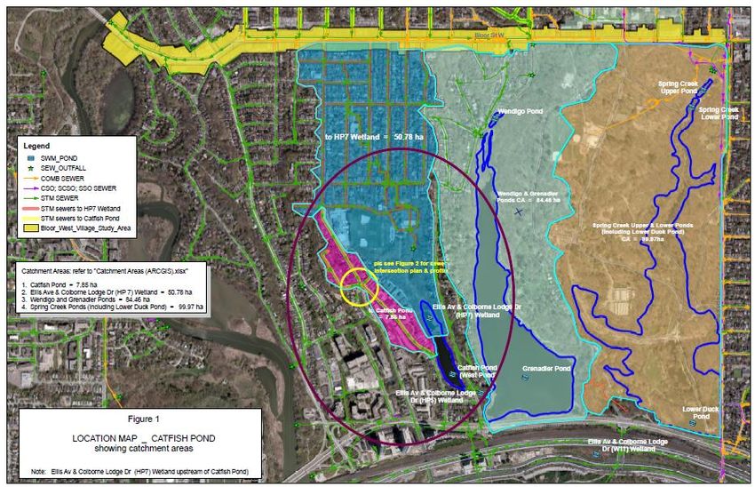
Executive Summary

This document has been prepared to support the Bloor West Village (BWV) Avenue Study by Toronto
Water staff with input from City Planning staff and Parks Forestry and Recreation staff. It documents
various small calculations and studies undertaken by City staff to fill gaps, identified after the Consultant
Assignments had been developed and initiated / and or completed, and is provided as a written record on
which the Consultant team can reply for purposes of developing their reports.

This document provides the foundation for understanding how upstream catchments contribute to High
Park Surface Water Features’ through surface water and groundwater pathways. The ‘High Park Surface
Water Features’ are designated as natural water systems, and include:

       a) Grenadier Pond, and
       b) Spring Creek.

This document also integrates the outcomes of two foundation studies into an impact framework to assist
in estimating the effect of future intensification within the BWV Avenue Study Area on High Park
surface water features, they include:

(i)       Groundwater (hydrogeology) report by WSP (WSP, 2018a); and
(ii)      Servicing Report (WSP, 2018b).

which are supporting reports to the Bloor West Village Avenue Study being prepared for the City by a
consulting team led by DTAH.

The integrating tool for looking at the effects of intensification on receiving waters (surface waters,
groundwater), through surface water and groundwater pathways, is the concept of watershed %
imperviousness.

Results

The maximum effect of intensification within the BWV Avenue Study Area on hydrological pathways
(surface water runoff, groundwater flow) flowing to the two High Park Surface Water Features
(Grenadier Pond, Spring Creek) is of the order of 1 %, using the potential change in impervious cover as
the measure of effect. This means that there is virtually no measurable effect of intensification within the
BWV Avenue Study Area on High Park Surface Water Features.

The small effect of intensification within the BWV Study Area is caused by the existing high level of
impervious cover (64 %) in the catchments flowing to Grenadier Pond and Spring Creek, which includes
the BWV Avenue Study Area. This level of impervious cover has largely been in place for ‘several
decades’, as this area has had a mature urban cover on these lands for that period of time.

Major changes within the urban catchments feeding High Park Surface Water Features over ‘these
several decades’ which have mitigated some of the effects of urbanization have included (i) combined
sewer separation with road sewers in the 1940s – 1970’s and (ii) retrofitting with end-of –pipe
stormwater management facilities in the Catfish Pond and Wendigo Creek systems feeding Grenadier
Pond, and Spring Creek Ponds and Lower Duck Pond within the Spring Creek system in the 2000’s, and
(iii) implementation of the City's mandatory roof downspout disconnection requirement since ca 2010.
Additional protection to the water quality of Lake Ontario, particularly beach bathing water quality in the
Western Beaches, has been afforded by construction of the Western Beaches Tunnel System which

                                                      2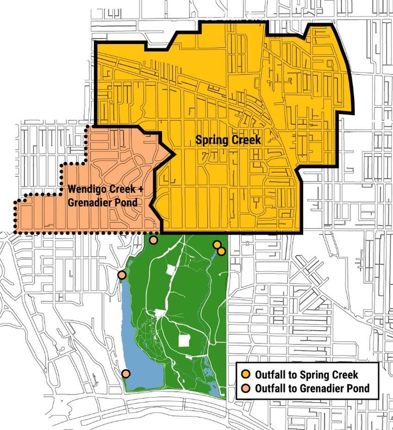
intercepts overflows from the combined sewer system adjacent to and largely east of High Park and
captures flows from Spring Creek.

Further mitigation of the effects of intensification within the BWV Avenue Study Area on surface water
and pathways flowing to High Park Surface Water Features is anticipated when re development occurs
through implementation of source control (e.g, low impact development) measures. Additional
opportunities may be afforded through the anticipated opportunity for developing Green Streets along
Bloor during future reconstruction, and an update of the High Park Management Plan.

                                                   3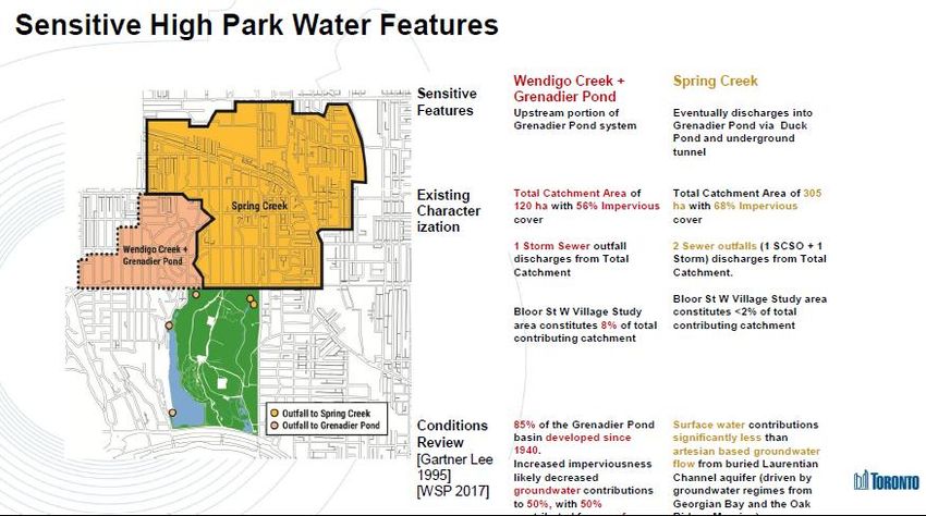
High Park Surface Water Features - Narrative
1 Introduction

This document describes the surface water and groundwater sources for the High Park Surface Water
features, summarizes the potential effects of intensification within the Bloor West Village Avenue Study
area on the High Park surface water systems, and describes mitigating measures needed to offset the effects
of development / redevelopment within the Study area.

It uses the concept of % Imperviousness as a master index to examine for the effects of intensification on
receiving waters (High Park Surface Water Features and groundwater aquifers). It is concluded that
potential effects of redevelopment within the Bloor West Village Avenue Study Area on surface water
runoff into High Park surface waters is of the order of 1 %, a small number.

2. Generic Impacts of Development on Surface Waters in High Park

In an urban environment like Toronto, the two major pathways which affect surface water systems are
surface water runoff, through overland flow and storm sewers, and groundwater flows which enter the
surface waters as springs and artesian flows.
2.1 What are the sources that potentially affect the functioning of natural water features (e.g., streams,
ponds) in High Park?

The water features in High Park are fed through the following sources:

1.    Surface Water.
Due to the predominantly urbanized nature of the upstream catchment areas, water features in the park are
mostly fed via stormwater runoff, captured, conveyed and discharged mainly through the City's storm
sewer infrastructure. A relatively small amount of surface water would be contributed by runoff from
surfaces within High Park itself.

2.   Groundwater
The two major types of groundwater systems in High Park are:
a.   Shallow Groundwater Flow Regime/Perched Aquifers, and
b.   Deep Aquifer/Underground Stream – like systems, such as the Laurentian Channel.

2.2 How can unregulated development impact the above water sources?

1.    Surface Water
Significant increases in imperviousness (e.g., paved areas) compared to preexisting conditions may result
in rapid and increased release of stormwater to overland flow routes (e.g., roads) and sewers and
ultimately to the receiving environment. Unmitigated, this may increase the risk of water quality and
habitat degradation, as well as raise urban flooding concerns.

2.   Groundwater

a.   Shallow Groundwater Flow Regime/Perched Aquifers

                                                    4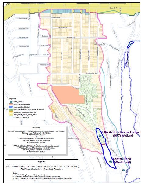
Significant increases in imperviousness may inhibit groundwater recharge and reduce groundwater levels
and flow regimes. Sub-surface structures (e.g., parking garages) may be located below groundwater levels,
requiring the extraction and discharge of groundwater to City sewers. Significantly large rates of permanent
discharge of groundwater may alter sub-surface groundwater regimes and also introduce potential for
degraded water quality as a result of groundwater discharges if lands are contaminated .

b.    Deep Aquifers/Artesian Systems
 Deep sub-surface structures (e.g., parking garages) may impact aquitards and cause pressurized release of
groundwater aquifers resulting in discharge of large volumes of water and creating unstable conditions for
existing infrastructure.

3. Integrating Concept for Evaluating the Effects of Urbanization on Receiving Waters

% Imperviousness, defined as the total impervious cover (ha) divided by total upstream watershed area(ha),
or total impervious cover is typically used as a master index or as an ‘Integrating Concept’ for evaluating
the effects of urbanization on receiving waters for environments such as the surface water
features of High Park (the Spring Creek system and the Grenadier Pond system). Figure 1 provides a
generalized estimate of changes in components of the rural – urban water balance for a reference watershed
/ catchment as the catchment urbanizes. Figure 1 shows the urbanization process from rural and
substantially treed catchment (Natural Ground Cover), through low density urban area (10 – 20
%Impervious Surface), followed by medium density (35 – 50 % Impervious Surface), and catchments
typical of urban malls or downtown areas (75 – 100 %Impervious Surface). For these four different
characteristics of urban lands, increasing imperviousness, leads to more surface water runoff, and decreases
in evapotranspiration and shallow infiltration and deeper groundwater recharge.

For the catchments upstream of the BWV Avenue Study area, the existing % imperviousness is
approximately 64 % (see Section 4 below), meaning that the catchments upstream of Bloor Street are
classified as above medium density from a hydrological perspective of Figure 1. From a perspective of the
urbanization gradient observed across the GTA from the downtown to the rural landscapes of the Oak
Ridges Moraine or farmlands in the headwaters of the Humber River watershed, this means that the
catchments feeding High Park Surface Water Features have already received a dominant effect of
urbanization - for example the volume of surface water runoff in the streams feeding High Park would have
approximately tripled or quadrupled (e.g., from 10 % to more than 30 %) when the rural condition (typically
of lands north of Bloor in the 1800’s) are compared to present day hydrological conditions ( see last two
images in Figure 1).

It should be noted that the changes in imperviousness can be used as a master index for evaluating
‘cumulative impacts of intensification on groundwater such as for maintaining predevelopment
“infiltration” to ensure no net impact to groundwater sources.

2.3 How can the City control the impact of redevelopment from the Bloor St W corridor on the above
water sources?

1.     Surface Water
The City's Wet Weather Flow Management Guidelines require all new / redevelopments to provide on-
site stormwater management (SWM) measures in order to control water balance, quality and quantity
from each site prior to discharge. Almost all existing land-uses within the Bloor St W study area pre-date
the requirements of the WWFMG and therefore release stormwater in an uncontrolled manner. Any new
development in the study area will be required to improve overall impacts of stormwater through the
implementation of SWM measures, as well as Green Infrastructure through the development application

                                                     5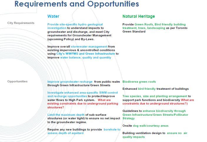
process in accordance with the WWMFG and the Toronto Green Standard (see also, Chapter 3 of the
BWVA Study report).

2.    Groundwater

In addition to meeting the City's WWFMG requirements for surface water, which is expected to increase
and improve overall recharge to the groundwater regime, the development application process requires the
submission of a site-specific review of subsurface hydrologic and geologic conditions to assess the site-
specific impact of proposed development on groundwater and its discharges. The City's current policies,
by-laws, as well as MOECC guidelines discourage the extraction and discharge of groundwater.

 Impacts on groundwater from developments in the BWV Avenue Study Area will be further mitigated by
controlling the maximum depth of sub-surface structures in order to ensure no net impact to the groundwater
regime. In addition, for each site, the subsurface investigation may include at least one monitoring well to
the top of the bedrock to rule out presences of underground buried channel. If buried channel is present
and unstable conditions are expected then underground basement levels will be restricted to avoid any
adverse                 impacts                 at                such                 sites.

3. Surface Water Features within High Park

There are two major catchments (Figure 2) which flow through High Park from north of the BWV Study
Area, (i) the Wendigo Creek /Grenadier Pond system on the west side of the Park, and (ii) the Spring Creek
system on the east side of the Park. Additional catchments which flow into the Grenadier Pond system are
generally located west of Ellis Ave (Figure 6) and have their headwaters south of Bloor Street (Figure 5).

Spring Creek System

The Spring Creek System includes the Spring Creek Ponds, located at the northwest corner of Parkside and
Bloor, which flow through Spring Creek to the Lower Duck Pond system and discharge to Western Beaches
Tunnel. The Spring Creek ponds (North and South Cells) and Lower Duck Pond were retrofitted as SWM
facilities in 1990's - 2000's . The Spring Creek ponds (North and South Cells) and Lower Duck Pond had
their accumulated sediments removed in the recent few years, to improve their water quality performance

The flow characteristics of the Spring Creek system is controlled by two major storm sewer systems that
discharge immediately south of Bloor into the North Cell of Spring Creek SWM Ponds. This system is
described as 'flashy' in which the Spring Creek Ponds have major flows to them within about a half hour of
the initiation of a rainfall event, and return to ambient water levels within 2 - 8 hours of a rain storm ceasing.
The flashy flows occasionally overtop the walkway between the north and south pond, causing erosion of
the walkway. Mention CSO here.

The Spring Creek SWM Ponds and Lower Duck Pond improve water quality through sedimentation of
suspended solids. In addition, the Spring Creek SWM Ponds have gone anaerobic twice over the past decade
during to a long period of drought due to elevated levels of oxygen demand in the influent; the City is
continuing to monitor the system and examining potential mitigating measures to address the observed low
oxygen levels. Increased intensification of Bloor Street will not have an impact on these episodes of low
oxygen.

In addition, groundwater from the Laurentian bedrock aquifer channel has a unique interaction with the
surface water system of the Spring Creek System. The High Park artesian well discharges to Spring creek
and creates an iron plume, near the outlet of the south Spring Creek Pond. Bubbles of methane of Queenston

                                                        6
Shale bedrock origin, can be observed on the surface of Spring Creek Ponds. It is suspected that the
Laurentian Bedrock channel is blocked by geological deposits between Spring Creek ponds and the lake,
causing springs to develop and discharge to Spring Creek - hence the name "Spring Creek". These springs
represent a few percent of all surface water flows found in Spring Creek
The Spring Creek discharge from Lower Duck Pond goes to the Western Beaches Tunnel because one of
its influent storm sewers has an internal upstream CSO
Information concerning the inwater biological life of the Spring Creek system is limited. The SWM
facilities are occasionally drawn down and emptied, limiting the extent of inwater biological life. During
and after removal of sediments from the Lower Duck Pond System, observers noted an extensive
occurrence of reptiles and turtles, including Snapping Turtles, whose presence was mitigated during the
sediment removal process.
The Grenadier Pond System
The Grenadier Pond System is composed of two major intermittent branches which flow into Grenadier
Pond, the Wendigo system located within High Park, and Catfish Pond located west of Ellis Ave. Grenadier
Pond itself is the dominant surface water feature, covering approximately 70 - 80 % of the length of High
Park between Bloor Street and Lakeshore Ave. The Wendigo SWM pond flows into the north end of
Grenadier Pond, while outflows from the Catfish Pond enter the South - west corner of Grenadier Pond
near to Lakeshore Blvd (Figure 5).
The Wendigo Stormwater Management pond acts as a sediment trap, before stormwater enters Grenadier
Pond. The Wendigo Stormwater Management Pond had accumulated sediment removed within the past
few years. The Wendigo Stormwater Management Pond is approximately as flashy as Spring Creek Ponds.
A lower portion of Catfish Pond and a small portion of Grenadier Pond was isolated to address Stormwater
Management objectives in the late 2000 decade. This resulted in construction of the Ellis Ave and Colborne
Lodge Dr (HP7) SWM wetland and the Ellis Ave and Colborne Lodge Dr (HP5) SWM wetland connecting
Catfish Pond (West Pond) to Grenadier Pond (Figure 5). In addition, other habitat projects such as shoreline
naturalization (Figure 4) have been undertaken on Grenadier Pond in the past two decades.
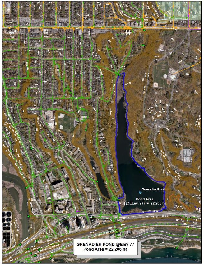
Grenadier Pond is a natural water body with a surface area much larger than that of Spring Creek Ponds (N
and South Cells) and Lower Duck Pond or the Wendigo SWM facility. Its surface area is of the order of 22
ha [Analysis of GIS information indicates that it would occupy 22.2 ha at elevation 77 masl, an elevation
which occupies small portions of the shoreline – see Figure 3]. Grenadier Pond's water levels are controlled
by Wendigo SWM inflows, Catfish Pond inflows, and Lake Ontario Water levels
The large surface area and interactions with Lake Ontario mean that Grenadier Pond water level variations
are slow, relative to the flashy character of the SWM ponds. During the record elevated water levels of
Lake Ontario in 2017, the water levels of Grenadier Pond were particularly controlled by back- water effects
from the lake.
The local groundwater table, thought to be a surficial aquifer, interacts locally with Grenadier Pond (feeds
Grenadier Pond). It is unlikely that this local groundwater system is influenced by the Laurentian Channel,
as a potential monitoring well drilled by TRCA in ca 2005 near Wendigo Pond, encountered bedrock within
a few meters of the surface. Additional insight on the potential for connections may be generated by the
anticipated update to Toronto’s Geology/hydrogeology in the next couple of years by the YPDT-CAMC
program (see http://www.ypdt-camc.ca)
7
Historical academic work on Grenadier Pond is illustrated by the Master's thesis of McCarthy (1986).
During the past few years, algal blooms, the evolution of cattail and similar communities, and circulation
patterns have been a dominant issue for Grenadier Pond, especially to members of the High Park Natural
Environment Committee (HPNEC), but little monitoring on its effects or causes are available to assist in
developing this narrative.

4. Improvements in Infrastructure

Historically, the catchments draining through High Park or around High Park, were sewered as a combined
sewer system if developed in the early 1900’s. The major catchments whose storm sewers flow to Wendigo
or Spring Creeks are identified as a part of the combined sewer service area (WSP, 2018b) By 1940, 85%
of the Grenadier Pond basin was urbanized (Gartner Lee, 1995) meaning that the present level of impervious
cover in the catchments draining through the BWV study area and High Park Natural features, of 64 % has
largely been in place for ‘several decades’, as these areas have had a mature urban cover for that period of
time. Redevelopments, such as conversion of single family houses, into the large apartment buildings, in
the 'Apartment Neighhourhood', have also occurred.

Major changes within the urban catchments feeding High Park Natural Water Features over ‘these several
decades’ have included (i) combined sewer separation with road sewers in the 1940s – 1970’s and (ii)
retrofitting with end-of –pipe stormwater management (SWM) facilities based on a stormwater quality
management plan for High Park of the late 1990s. SWM facilities were built in the Catfish Pond and
Wendigo Creek systems feeding Grenadier Pond, and Spring Creek Ponds and Lower Duck Pond within
the Spring Creek system mainly in the 2000 decade, and largely completed by 2010. Presently, assessments
of maintenance requirements for these SWM facilities have been undertaken, and sediment removal
completed in the Spring Creek Ponds and Lower Duck Pond in 2015-2017.

Additional protection to the water quality of Lake Ontario, particularly beach bathing water quality in the
Western Beaches, has been afforded by construction of the Western Beaches Tunnel System which
intercepts overflows from the combined sewer system adjacent to and largely east of High Park, intercepts
flows from Spring Creek. The WBT system was completed in the early 2000’s.

With the adoption of the Wet Weather Flow Master Plan (WWFMP) and the Wet Weather Flow
Management Policy by Toronto City Council in 2003, the associated WWF Management Guidelines is the
technical document which defines the requirements for managing water quantity, water quality, and water
balance for redevelopment of private lands within the City of Toronto, including the catchments flowing to
the High Park Surface Water Features. The WWFMP (2003) initially used a voluntary approach for roof
downspout disconnection, in the 2000 decade. With the advent of basement flooding episodes associated
with major storms such as the Aug 19th 200 5 extreme storm, the City of Toronto Council approved
mandatory downspout disconnection, with the deadline of Nov 20 2011 being applicable to the catchments
located north of the BWV Avenue Study area.

5. Estimated Impacts of Intensification of Bloor West Village Avenue Study Area on High
Park’s Spring Creek and Grenadier Pond Surface Water Systems

Toronto Water Mapping

Toronto Water has produced catchment maps (see Figure 2) for stormwater catchments located north of
Bloor Street which flow into Wendigo Pond (the Grenadier Pond System) and the Spring Creek system,

                                                     8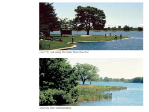
respectively based on existing sewershed and watershed contours. The key data/information is summarized
as follows:

           Wendigo Pond
           o Outfall from areas catchments serviced by storm sewers
           o Total Contributing Catchment ~120 ha (out of which, only 10 ha resides in the BMV study
              area)
           o Total Catchment Imperviousness ~56%

           Spring Creek
           o Outfalls from 2 catchments serviced by SCSO sewers and storm sewers, respectively
           o Total Contributing Catchment ~305 ha (out of which only 5 ha resides in the BMV study
               area)
           o Total Catchment Imperviousness ~68%

Table 1 Summary of Imperviousness Characteristics in Wendigo and Spring Creek Catchments
                              Catchment Characteristics Flowing to      Bloor West Village Avenue Study
                               High Park Surface Water Systems?         Area Characteristics within Each
                                                                              High Park Catchment
                                 Total Area        Impervious Area       Total Area      Impervious Area
 Wendigo Sewershed                 120 ha                67 ha             10 ha              5.6 ha
 Spring Creek Sewershed            305 ha                207 ha             5 ha              3.4 ha
 Total Area                        425 ha                274 ha            15 ha               9 ha

This analysis indicates that the total impervious area (274 ha) constitutes an average of 64 % imperviousness
of the total catchment area (425 ha) which flows to these two surface water systems in High Park, and that
the impervious area within the BWV Avenue Study Area (9 ha) constitutes 3.2 % of the total impervious
surface area (274 ha) in these two catchments.

Under a conservative assumption, if intensification causes the impervious area within the BWV Avenue
Study Area corridor to increase to 80 %, the resultant imperviousness (12 ha) would increase to 4.4 % of
the upstream impervious surface area (274 ha), from the present value of 3.3 % (9 ha)(Table 1). That is,
intensification could cause a potential change in impervious cover of the order of 1 %, as the measure
of effect. A value of 1 % change means that there is virtually no measurable effect of intensification
within the BWV Study Area on High Park Surface Water Features.

This information was presented at the December 5 2017 Community Meeting and represents the summary
record used for purposes of the BWV Avenue Study

A further review of catchments feeding Grenadier Pond identified additional catchments west of Ellis Ave.
Figure 5 and 6 provide catchment boundaries for (i) the catchment flowing to Ellis Ave and Colborne Lodge
Dr (HP7) SWM wetland and (ii) an additional catchment flowing to Catfish Pond (West Pond). There is a
small portion of the BWV Study area in HP7 SWM Wetland catchment (Figure 6) with an impervious area
of 98 % composed largely of commercial residential uses compared to the overall catchment impervious
level of ca 52 % (Table 2). As this area of the HP7 SWM Wetland catchment (Figure 6) is essentially 100
% imperviousness, intensification will not increase the fraction of impervious cover, and may actually
decrease the extent of impervious cover through landscaping and other measures.

                                                     9
Table 2. Characteristics of Catchments to West of Ellis Ave flowing to Grenadier Pond
Catchment Characteristics BWV Avenue Study Area
Catchment Characteristics
Catchm Total %I Catchmen Total %I
ent Area Impervious t Area Impervious
(ha) Area (ha) (ha) Area (ha)
Ellis Ave & Colborne Lodge 50.8 25.8 51 1.42 1.39 98
(HP7) Wetland Catchment
Catfish Pond Catchment Area 7.8 4.1 52 0 0 -
Total (west of Ellis Ave) 58.6 29.9 51 1.42 1.39 98
High Park Apartment Neighbourhood Area
Coincident with the BWV Avenue Study, City Planning has initiated a study of the apartment
neighbourhood immediately north of the BWV Avenue Study Area (City of Toronto 2017) with the purpose
of 'evaluating the existing area characteristics, and identifying appropriate policies, principles, and
guidelines that will guide change and compatible infill development in the High Park Apartment
Neighbourhood'.
City Planning requested Toronto Water to provide information on how underground parking structures
affect the estimation of % imperviousness. It is noted that underground parking structures extend well
beyond the boundaries of the above grade structures, in some blocks accounting for 100% coverage of the
lot area. The premise is that underground parking structures would further reduce infiltration and the area's
contribution to ground water recharge. In addition, it is noted that parking garage structures are covered by
a combination of hard and soft surfaces. The hard areas would be captured by Toronto Water's
imperviousness calculation method. But, while the soft components are designed like intensive green roofs,
so there would be some surface level holding capacity, they would not ultimately allow rainwater to
infiltrate deeper to recharge groundwater.
The percentage imperviousness is calculated by measuring the percentage of a catchment area which is
made up of impervious surfaces such as roads, roofs and other paved surfaces. As such, the presence of
underground parking structures will not impact the calculation. This illustrates the point that while %
Imperviousness has evolved to be a master index to reflect the effects of urbanization on surface water
pathways, it is imperfect as an index to describe the integrated effects of urbanization on recharge to deep
groundwater systems (Figure 1) in situations when there are underground structures that extent beyond
the building footprint.
As a part of the High Park Apartment Neighbourhood Study, an assessment of the estimation of %
Imperviousness was undertaken using two different data sources. Considering existing parcels, similar to
calculations made above for Wendigo and Spring Creek catchments, the percent imperviousness of the
Apartment Study Area is 56 %. Using more detailed information including existing parking areas and
landscape details, the percent imperviousness is 62% within the Apartment Study Area.
Flow Estimates for Surface Water and Groundwater Sources
The catchment map (Figure 2) may not match exactly those from older reports. Irrespective, this
information is used to provide order of magnitude comparisons between flows in the surface water system
and order of magnitude estimates of groundwater flows into the surface water systems.
10Based on an assumed annual precipitation of 750 mm and runoff coefficient from impervious areas of 90
% and a runoff coefficient from pervious areas of 30 %, the average annual runoff into Wendigo Creek
is17 L/s and into Spring Creek is 41 L/s from the respective upstream stormsewered areas.
Gartner Lee (1995) undertook a surface and groundwater review of Grenadier Pond, including field work
around Grenadier Pond to estimate groundwater inflows. Key statements in their 1993-94 studies include:
85% of the Grenadier Pond basin has been developed since 1940.
As a result of this development and overall increased imperviousness, annual groundwater
contributions to the pond has likely decreased from 65% to 50%, with the contribution from storm
water runoff making up the balance of the remaining 50%.
Mini-piezometer readings in the pond have confirmed that groundwater is discharged into the
pond. Although the flux or measured discharge couldn't be physically estimated, Gartner Lee
estimated that the groundwater flow to Grenadier Pond would be in the range of 15 L/s to 50 L/s.
Relative to the above estimated annual surface water flow into Grenadier Pond of ca 17 L/s from the
Wendigo Creek system, these order of magnitude groundwater estimates are of the same order of
magnitude. In addition, the surface water flows into Grenadier Pond from the Catfish Pond sewershed
(located mainly to the west of Ellis Ave), are not included in the above estimates for Wendigo Creek; based
the catchment area for Catfish Pond of 58.6 ha (Table 2), the surface water flows into Grenadier pond from
sewered catchments are of the order of 23 L/s, and hence a similar order to that for groundwater inflows
from the local aquifer system.
Based on the relatively stable nature of urban development within the Wendigo and Spring Creek
catchments upstream of Bloor Street and the Bloor Street study area since the Gartner Lee study, it is
reasonable to state that their findings would not change much for present 2010 decade conditions or future
development.
For the Spring Creek System, the annual surface runoff rate of 41 L/s is larger than the artesian based
groundwater flow into Spring Creek from the buried Laurentian Channel aquifer, currently estimated as 70-
90 L/min (120 m3/day Figure 11). As the flow system is driven by groundwater regimes from Georgian
Bay and the Oak Ridges Moraine, development within the Study Areas will not measurably affect this flow
rate, provided that re-development does not puncture the aquitard located subsurface.
Effects of Intensification in Bloor West Village Study Area on Receiving Waters in High Park
Changes in imperviousness are used as a master index to evaluate the effects of intensification within the
Bloor West Village Avenue Study Area on surface water flows to Surface Water Features within High
Park. Future intensification within the Bloor West Village Avenue Study Area is estimated to cause an
increase in impervious cover in catchments north of Bloor Street of the order of 1 %. A change of 1 %
imperviousness is forecast to cause a similar change in the annual volume of surface water runoff into the
High Park surface waters. A change in of the order of 1 % is a small number, and a value which would not
be detectable with conventional surface water flow monitoring technologies. This information was used to
support the Dec 5 2017 Community meeting.
The additional information gathered for catchments west of Ellis Ave does not change this perspective. The
present impervious cover within the BWV Avenue Study Area is 2 % of the impervious cover in the
catchments flowing to Catfish Pond (West Pond) and then into Grenadier Pond. But because the existing
impervious cover of the BWV Avenue Study Area is 98% of the local catchment area, intensification would
not materially change the present extent of impervious cover which is presently largely impervious cover.
11From a perspective of evaluating historical changes in urbanization in the catchments flowing into High
Park, it is noted above in Section 2 and 3 that the catchments feeding High Park Surface Water Features
have already hydrologically received the dominant effect of urbanization – the dominant effect of
urbanization occurred between when the lands were largely rural in the latter part of the 1800’s and the
current development form which was largely completed by the 1950’s. Comparatively, future
intensification within the Bloor West Village Avenue Study Area will have a very small (e.g., not
measurable) effect, relative to the historical changes that have occurred as the catchments urbanized.
Changes in imperviousness can also be used as a master index for evaluating ‘cumulative impacts of
intensification on groundwater such as for maintaining predevelopment “infiltration” to ensure no net
impact to groundwater sources. An increase of 1 % of impervious cover in surface water catchments north
of Bloor St would have a comparable net effect of decreasing net recharge by of the order of 1 %, a small
number which would not be measurable for the recharge potential to any aquifer feeding Grenadier Pond.
Conclusion from this Section
Percent Imperviousness or total impervious area is a master index used in stormwater management to assess
the effects of development on receiving water systems
The anticipated increase per cent imperviousness is ca 1 %. This will increase total annual runoff by
approximately 1 %, a small number, and an amount that can be calculated, but not measured. Hence the
effects of the Bloor West Village Avenue Study Area redevelopments anticipated in this project will not be
measureable.
6. Mitigation of Effects of Intensification within BWV Study Area
There are a number of additional opportunities to mitigate the potential impacts of development on surface
water and groundwater sources feeding High Park water features.
The Ontario Ministry of the Environment and Climate Change (MOECC) and City of Toronto have existing
policies and guidelines outlining requirements to address groundwater and stormwater management
(SWM).
In addition to the MOECC's Stormwater Management Planning and Design Manual, through the City's Wet
Weather Flow Management Guidelines (WWFMG), and the Toronto Green Standard (TGS), improvements
to overall surface water sources are expected through the implementation of on-site water balance (i.e.,
retention), quality and quantity controls as where new development takes place on existing sites within the
study area where a high impervious coverage already exists with little to no SWM controls in place.
Additional opportunities to improve groundwater recharge exists through the use of Green Infrastructure
and Low Impact Development (LID) features within the City's right-of-way, as well as on development
sites, as per the City’s Wet Weather Flow Master Plan (WWFMP), Green Street Technical Guidelines, and
upcoming Ministry of Environment and Climate Change (MOECC) direction.
In addition to the submission of site-specific Stormwater Management reports, as part of the development
approval process, development projects are also currently required to provide site-specific hydrogeological
investigations to understand impacts to groundwater and discharge, and meet City requirements for the
forthcoming Groundwater Management Policy and Sewer Use By-Law.
12The above summary of effects of intensification, mitigation, and recommendations formed the basis for
material presented at the Dec 5th Community meeting, provided below as Figures 8-10.
7. Consultation with Mississauga’s of the New Credit
Members of the City team met with members of Mississauga’s of the New Credit First Nation (MNCFN)
at their offices (2789 Mississaugas Rd, Hagersville Ont, H0A 1H0) in Feb 2018, to provide insight into
characteristics of the BWV Avenue Study Area, and the Planning Context for this Study. A MNCFN
member who specializes in their history, outlined the occupation and use of the lands by the different First
Nations from roughly 1500 to present, with a particular emphasis on the Mississauga’s territory within
Southern Ontario from 1781, including approximately 9 treaties since 1781, and a settlement with Canada
for land claims in ca 2012. A new claim was submitted in 2015 for the Rouge Tract (which includes the
proposed lands of the Rouge National Urban Park), and a claim for water bodies and groundwater aquifers
roughly within their 1781 lands, including portions of Lake Ontario are being researched. Of particular
interest to the MNCFN members in the vicinity of the BWV Study Area, are the aquifers associated with
the Laurentian Channel, surface water bodies such as the Humber River, and the nearshore waters of Lake
Ontario, including the Toronto Islands.
Improvements in understanding of the Laurentian Channel (documented in WSP,2018a; and Slide NWH-
19, December 2017 Community Meeting), the well drilling necessary to depressurize the artesian aquifer
below Spring Creek Ponds in 2004, during construction of the Ponds, and surface water catchments
(Wendigo Creek, Spring Creek) which flow through the BWV Study area to Lake Ontario (documented in
WSP,2018b; and Slide NWH-17, December 2017 Community Meeting) were discussed. Of particular
interest to MNCFN members was that the upstream storm water systems flow directly into the High Park
Natural Features, but that these storm sewers are underlain by the combined sewer service area, with an
internal overflow to the Spring Creek system. City staff pointed out that combined sewer overflows to Lake
Ontario in the vicinity of Parkside as well as Spring Creek discharges are intercepted by the Western
Beaches Tunnel, prior to their treatment.
8. Concluding Remarks Re Impacts of Intensification along Bloor Street.
The most valuable surface water feature within High Park is Grenadier Pond . All other features are either
small stormwater ponds or creeks which feed Grenadier Pond, or which flow in the separate Spring Creek
system and discharge to the CSO control facility, the Western Beaches Tunnel, located ca 40 -50 m below
lake level and along the edge of Lake Ontario.
The hydrology of Grenadier Pond is dominated by flashy stormwater inflows from the storm sewer system
north of Bloor Street, and the stormsewer system located west of Ellis Ave, which discharges through
Catfish Pond into Grenadier Pond. The outflow from Grenadier Pond is dominated by Lake Ontario water
levels and the weir setting on the Pond outlet; when the lake level is elevated such as in 2017, much more
water is retained in the Pond that occurs in normal years.
As Grenadier Pond is a shallow water pond, its internal circulation is generally dominated by wind driven
currents, except when ice covered.
Anecdotal observations have been presented by concerned citizens to the Bloor West Village Ave Study
team about the observed biochemical changes in Grenadier Pond and their concerns related to past and
future intensification effects.. As a thorough going hydrological and limnological study of Grenadier Pond
has not been found, this document is limited to developing some general statements about these concerns
expressed by concerned citizens.
13Percent imperviousness in a catchment is the master index that can be used to examine the effects of urban
development on the hydrology and water quality of natural water bodies such as Grenadier Pond and the
Spring Creek system.
The analysis presented in Sections 5 – 6 (above) indicates that intensification along Bloor Street is expected
to change the total annual volume of runoff from catchments feeding water bodies such as Grenadier Pond
and the Spring Creek system by ca 1 %. A value of approximately 1 %, is a very small number, ---- an
amount that can be calculated, but not measured. Hence the effects of the BWV intensification
/redevelopments anticipated in this project will not be measureable.
That is, the dominant effect of flows from urban areas into Grenadier Pond is the variability in amounts of
precipitation from season to season and from year to year within the contributing stormwater catchments
flowing into Grenadier Pond. The dominant effect on Grenadier Pond water levels are the seasonal volume
of inflows and the Lake level, not intensification along Bloor Street. That is the existing built urban form
and the existing upstream stormwater runoff system, rainfall patterns, and lake levels have the dominant
effect on the hydrology of Grenadier Pond.
Additional changes in the ecology of Grenadier Pond are occurring due to the internal response of algae
(floating plants) to nutrient conditions and development of emergent plants such as cattails. A limnological
study of Grenadier Pond such as could be carried out by the research of a Masters student's thesis would be
one potential approach to address these issues
9. Recommendations
1. Special Studies should be undertaken to improve our understanding of ecology of Grenadier Pond
system. In particular,
a) Insight into the potential for connections will be generated by the anticipated update to Toronto’s
Geology/hydrogeology in the next couple of years by the YPDT-CAMC program.
b) A limnological study of Grenadier Pond could be carried out by the research of a Masters
student's thesis is needed to address such issues as filamentous algae, and the evolving patterns
of emergent vegetation across the Pond.
2. For redevelopment applications, it is essential that
a) the requirements of the City's Wet Weather Flow Management Guidelines for all new /
redevelopments to provide on-site stormwater management (SWM) measures in order to control
water balance, quality and quantity from each site prior to discharge, be fully met. Any new
development in the study area will be required to improve overall impacts of stormwater through
the implementation of SWM measures, as well as Green Infrastructure through the development
application process in accordance with the WWMFG.
b) With respect to Groundwater, the development application process requires the submission of site
specific Hydrogeological impact reports assessing the site-specific impact of development on
groundwater and its discharges.
c) Impacts of groundwater from developments in the area shall be further mitigated by controlling the
maximum depth of sub-surface structures in order to ensure no net impact to the groundwater
regime. This will ensure that the concept of a safe excavation depth is rigorously adopted.
d) For each site the subsurface investigation shall include at least one monitoring well to the top of the
bedrock to rule out presence of underground buried channel, or that the depth to the regional
aquitard is sufficient to prevent incursions into the artesian system. The hydrogeological
14information is to be provided by each redevelopment proponent to the YPDT-CAMC program to
allow this program to update the subsurface information in the Bloor St Study area, and regionally.
3. At the Dec 2017 Community Meeting, the following recommendations were presented for hydrogeology:
a) Investigate enhanced area-specific recharge requirements for sensitive areas.
b) Limit the maximum depth of sub-surface structures in order to ensure no net impact to the
groundwater regime.
c) Confirm no impedance of aquifer or hydrogeological/geotechnical impact through monitoring well.
11. References
Anon. Grenadier Pond, the History of Grenadier Pond Rehabilitation
http://www.highparknature.org/wiki/wiki.php?n=Explore.GrenadierPond,
City of Toronto (2017). High Park Apartment Neighbourhood Area Character Study (Study in progress,
Feb 2018)
DTAH (2018a) Planning and Policy Context. Chapter 2 of BWV Final Report.
DTAH (2018 b) Natural Heritage and Water Summary. Chapter 10 of BWV Final Report
DTAH (2018 c) Implementation. Chapter 11 of BWV Final Report
Gartner Lee (1995) Surface and Groundwater Review of Grenadier Pond,
https://www.highparknature.org/wiki/uploads/Resources/GartnerLee1995-report-textonly_Part1.pdf
https://www.highparknature.org/wiki/uploads/Resources/GartnerLee1995-report-textonly_Part2.pdf
(Specifically see Pages 4 – 17 ):
McCarthy, Francine (1986). "Late Holocene water levels in Lake Ontario : evidence from Grenadier
Pond". M.Sc.Thesis. University of Toronto. Available through the University of Toronto, or the Stacks
Royal Ontario Museum QE191 .M32 1986
WSP(2018a) “Desktop Hydrogeological Investigation – Bloor West Village, Toronto Ontario”
WSP (2018b) BWV Ave Study: Municipal Servicing – Future Conditions Report” (dated Feb 2018)
15Figure 1. Effects of % Imperviousness on components of the rural and urban water balance
16Figure 2 Catchments North of Bloor St Flowing to Surface Water Features of High Park
17Figure 3 Surface Area of Grenadier Pond.
18Figure 4 Shoreline Naturalization of Grenadier Pond within High Park
19Figure 5 Location map of catchment flowing to Ellis Ave and Colborne Lodge Dr (HP7) SWM wetland
and additional catchment flowing to Catfish Pond (West Pond)
20Figure 6 Catchment boundaries of catchment flowing to Ellis Ave and Colborne Lodge Dr (HP7) SWM
wetland and additional catchment flowing to Catfish Pond (West Pond). Note small portion of BWV
Study area in HP7 SWM Wetland catchment.
21Figure 7. Study Area for High Park Apartment Neighbourhood Area Character Study
Figure 8 Sensitive High Park Water Features (abstracted from Dec 2017 Community Meeting Slide
MHW-17)
22Figure 9 Potential development impacts on Sensitive High Park Water Features and Natural Heritage
(abstracted from Dec 2017 Community Meeting Slides)
23Figure 10 Requirements and Opportunities re Sensitive High Park Water Features and Natural Heritage
(abstracted from Dec 2017 Community Meeting Slides)
24Figure 11. Flow estimates from High Park flowing well (2010 – 2014).
25You can also read