How to Transition to the United States 2022 National Coordinate System Without Getting Left Behind - Edward E. Carlson
←
→
Page content transcription
If your browser does not render page correctly, please read the page content below
How to Transition to the United States
  2022 National Coordinate System
    Without Getting Left Behind

             Edward E. Carlson

         NOAA, National Geodetic Survey
         Pacific Region Geodetic Advisor
               ed.carlson@noaa.gov
The National Geodetic Survey (NGS)
      Our Nation’s first science agency

      1807                  1807                 1878            1970
 Thomas Jefferson     Ferdinand R. Hassler   U.S. Coast and     NOAA is
Survey of the Coast   First Superintendent   Geodetic Survey   established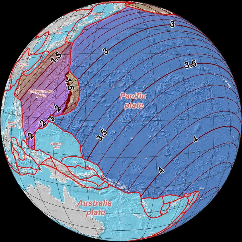
NGS Provides the Geospatial Infrastructure
Critical to Our Economy through the NSRS
                                                           Aviation

                                                                                        Satellite
                            Precision Agriculture                                       Operations

Trucking and Shipping           Surveying                  Disaster Response            Personal
                                and Mapping                                             Navigation

CORS           Navigation                Oil Exploration          Fishing and Boating

                                                                                        Survey Marks
NGS Programs
 Modernizing the NSRS

   CORS           Height Modernization        GRAV-D         Ecosystem and
                                                            Climate Operation

 NGS Products and Services

Airport Surveys            OPUS               VDatum        GPS Satellite Orbits

Coastal Mapping       Regional           Emergency
                      Advisor Program    Response Imagery
National Spatial Reference System
                        Ties It All Together
•   LiDAR
•   Digital Terrain Model
•   Aerial Photography
•   Cartography
•   Parcels
•   Engineering
•   Laser Scan Model
•   Satellite Imagery
•   Hydrography
•   Natural Resources
                                  Horizontal / Vertical Control
                                           (NSRS)

                                                                  P028 2005

                BUTTERMILK 1833
NSRS - Evolved Over Time

  +      +      +         +         +       +       time
< 10m   ~ 10m   1m       0.1m       0.01m   0.01m
                 Network Accuracy
NAD83 Shortcomings
o 2.2 m offset – NAD83 vs.

                                                     ITRF/WGS84
• International Terrestrial Reference Frame (ITRF)
   [~ International GNSS Service (IGS)]
• World Geodetic System 1984 (WGS84)

o CORS  passive network “disconnect”

                                                                  vs.
Why replace
    NAD 83 & Vertical Datums?
•   Main driver: Global Navigation Satellite System (GNSS)

•   ACCESS!
     – GNSS equipment is fast, inexpensive, reliable (and improving)
     – Reduces reliance on finding survey control (“bench marks”)
•   ACCURACY!
     – Insensitive to distance-dependent errors; reliable
     – Immune to bench mark instability (referenced to CORS)
•   CONSISTENCY!
     – Eliminates systematic errors in current datums
     – Aligned with global reference frames
     – Integrated system for both positions and heights (“elevations”)
The National Geodetic Survey
            Ten-Year Plan

Support the users of the National
Spatial Reference System.

Modernize and improve the National
Spatial Reference System.
( i.e., Replace NAD83 & NAVD88 )

Expand the National Spatial Reference
System stakeholder base through
partnerships, education, and outreach.

Develop and enable a workforce with
a supportive environment.

Improve organizational and administrative
functionality.
2022 Datums Goals
❖ “Replace NAD83” - By 2022,
reduce all definitional & access-
related errors in geometric
reference frame to 1 cm when using
~30 min of GNSS data
❖ “Replace NAVD88” - By 2022,
reduce all definitional & access-
related errors in orthometric
heights, relative to sea level, in
geopotential datum to 2 cm when
using ~30 min of GNSS data
❖ Provide tools to easily transform
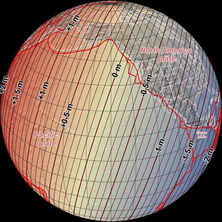
between new old datumsFour Tectonic Plates NGS Monitors In 2022, the entire National Spatial Reference System (NSRS) will be modernized and will contain four new reference frames: ✓ North American Terrestrial Reference Frame of 2022 (NATRF2022) ✓ Pacific Terrestrial Reference Frame of 2022 (PATRF2022) ✓ Caribbean Terrestrial Reference Frame of 2022 (CATRF2022) ✓ Mariana Terrestrial Reference Frame of (MATRF2022)
Guiding Principals
• By 2022, the National Spatial Reference System (NSRS)
  will be modernized with CORS becoming a more
  foundational component.

• The International Earth Rotation and Reference Systems
  Service (IERS) International Terrestrial Reference
  System (ITRF) will continue to be the worldwide standard
  reference system.

• NGS will continue to support the ITRF through
  International GNSS Service (IGS) reference sites.

• The NSRS will continue to be defined in relation to the
  ITRF.
Current Continuously Operating
  Reference Stations (CORS)

                  •   ~2300 Continuously Operating
                      Reference Stations

                  •   Run by more than 200
                      organizations (various
                      government, academic, and
                      private organizations)

                  •   Provide access to the U.S.
                      National Spatial Reference
                      System
Foundation CORS Requirements
• Baseline Foundation CORS Network:
➢ COLLOCATE - All Sites within the Foundation CORS target
area of the United States, that have an existing space geodetic
techniques (SLR, VLBI or DORIS) will have a collocated
Foundation CORS
• Additional Desired Foundation CORS Network
Requirements:
➢ DENSITY – Install or adopt new stations within the Foundation
CORS target area of the United States, to fulfill the spacing
criteria of 800 km within the Foundation CORS target area, after
the above criteria are met.
➢ EULER – Install or adopt new stations within the Foundation
CORS target area of the United States to raise the minimum
number of Foundation CORS to 3 on each of the 4 plates of
interest, once the above criteria are met.
➢ ADDITIONAL (Gap Filling) – Install or adopt new stations, on
a case-by-case basis, once the above criteria is met.Foundation CORS tentative target Criteria 1. Co-located with space-based technology 2. Density 3. Euler pole 4. Additional site (Bermuda)
All coordinates
               &
ellipsoid heights will change!
Approximate Horizontal Change
NAD 83 (2011/PA11/MA11)
epoch 2010.00 →
2022 Terrestrial
Reference Frames
Horizontal change at
epoch 2022.00
(contours in meters) MATRF2022
PATRF2022Approximate Ellipsoid Height Change NAD 83 (2011/PA11/MA11) epoch 2010.00 → 2022 Terrestrial Reference Frames Change in ellipsoid heights at epoch 2022.00 (contours in meters)
Problems in the Vertical with NSRS

 Earth’s
 Surface    H (LMSL)
                                 H (GPS-OH)

GPS-OHs

                                                  HNL BEN
           Errors : ~50 cm average,               Geoid12A
                   100 cm CONUS tilt,
                                                  5.894 = 21.090 – (+15.196)m
                    50/70 cm in Hawaii
                   1-2 meters average in Alaska   5.894 = 5.320m (LMSL)
                                                  Difference ~ 0.574m or 1.87ft
2022 Vertical Datum
• Changing from a leveling-based to a geoid/GNSS-
based vertical datum
• Biggest requirement: An updated,
accurate, nationwide gravity survey
– Airborne
– GRAV-D!
• Gravity for the Redefinition of the
American Vertical Datum
http://www.ngs.noaa.gov/GRAV-D/pubs/GRAV-D_v2007_12_19.pdfExtent of Gravimetric Geoid Model
NAPGD2022
Guam and Northern Marianas Islands
American SamoaInternational Coordination • IAG (Comm. 1 & 2) – ITRF/IHRF – SIRGAS – APREF • UN-GGIM – UN-GGRF – UN-GGIM-Americas – UN-GGIM- AP • FIG et al. • ISO – TC 211, TC 172 • GLCC – IGLD update
Positioning With 2022 Datum
Four Frames/Plates in 2022

                    NATRF2022

       MTRF2022                 CTRF2022

              PTRF2022

                                           Image from UNAVCO
Euler Pole Each reference frame will get: ➢ Euler Pole Latitude/Longitude ➢ Rotation rate (radians/year) Used to compute time-dependent TRF2022 coordinates from time-dependent global (IGS) coordinates Euler's fixed point theorem states: any motion of a rigid body on the surface of a sphere may be represented as a rotation about an appropriately chosen rotation pole (“Euler Pole”)
Using the TRFs                                                     User Supplied

                                                                                              NGS Supplied
GNSS Receiver File(t)         CORS data (t)
                                                                                              IAG Supplied
      OPUS
                                                                                            Geodetic Control
 XYZ (t, IGS)                 GRS-80               flh (t, IGS)                               High Accuracy
                                                                                           Fixed at true epoch
4 Euler Poles, by plate:                                                                     Estimated cords
    NA, PA, CA, MA                                                                          Medium Accuracy
                                                                                            Subject to updates
XYZ (t, NATRF2022)
XYZ (t, PATRF2022)
XYZ (t, CATRF2022)
XYZ (t, MATRF2022)
                                       4 Intra-Frame Velocity Models, by frame:
                                                                                  Latest estimate of:
           GRS-80                                  NA, PA, CA, MA
                                                                                  flh (t0, NATRF2022)
                                                                                  flh (t0, PATRF2022)
       flh (t, NATRF2022)                                                         flh (t0, CATRF2022)
       flh (t, PATRF2022)                            Most recent                  flh (t0, MATRF2022)
       flh (t, CATRF2022)                           past reference
       flh (t, MATRF2022)                            epoch “t0”

                           Blueprint for 2022, Part 1: Geometric Coordinates
CORS Velocities Hawaii
IGS08CORS Velocities Hawaii
PATRF2022
After Euler Pole Correction and IFVM applied for Pacific Terrestrial ReferenceBenefits of the 2022 Datum
Improved 3DEP and other topographical products
USGS More accurate representation of the physical world in our
elevation (and other georeferenced) products
More accurate horizontal and vertical coordinates for NFIP
FEMA NFIP requires thousands of precise horizontal and vertical measurements of
buildings to know where water will flow during floods
Consistency of vertical datums across the country
USACE Improved accuracy of GPS derived elevations and a better relationship
between geodetic and hydrologic datums to manage levies and waterways
FAA More closely aligns US NAS to global system (WGS 84)
Improved horizontal and vertical coordinates for airport obstacles
NGA More closely aligned with WGS 84 and ITRFMahalo
Questions ????
Contact Information:
Edward E. Carlson
Pacific Regional Geodetic Advisor
National Geodetic Survey
Phone: (808) 725-5255
email: ed.carlson@noaa.govYou can also read