HURRICANE GUIDE - THE TIME TO PREPARE IS NOW! 2020 - OpusCare
←
→
Page content transcription
If your browser does not render page correctly, please read the page content below
The Official South Texas

                   HURRICANE GUIDE
                                                         2020

                          THE TIME TO
                        PREPARE IS NOW!
                                          WEATHER.GOV/CORPUSCHRISTI
2020 South Texas
Hurricane Guide                                                   9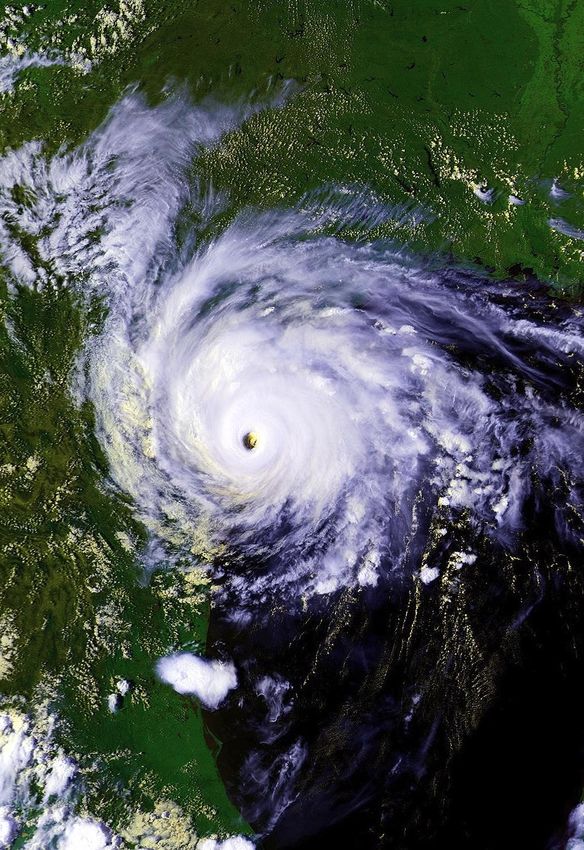
A Letter to Residents
   It’s that time of year again, South Texas. Welcome to the 2020 Hurricane Season.
   The year so far has been a remarkable mix of perseverance and adaptation, and
   these skills will be very important for our region as we head into the next few
   months. The unique challenges many of us are facing, including different work or
   school environments, where and when we buy groceries, and even how we
   communicate with each other are all chances for us to think about how we will
   prepare for the next hurricane. And the time to prepare is now.
   This guide contains updated information for 2020 on hurricanes, as well as the
   many hazards they can bring to the Coastal Bend. Deadly storm surge, damaging
   winds, flooding rain, and tornadoes can displace you from your home for months
   or years. Use this guide to help you and your family prepare as well as learn what
   to do before, during, and after a storm. If you are still spending time at home,
   take this time to plan out what supplies you need for hurricane season and what
   work needs to be done to prepare your home. In the coming weeks, use
   shopping trips or deliveries to help you stock up on supplies.
   Although the region experienced Hurricane Harvey three years ago, this does not
   mean that we are protected from the next hurricane. In fact, there have been 15
   occasions in which storms have impacted the Middle Texas Coast three years
   apart, dating back to 1850. One of the most notorious storms on this list, 1970’s
   Hurricane Celia, made landfall in the Coastal Bend three years after Hurricane
   Beulah and destroyed thousands of homes and businesses as it lashed the
   Coastal Bend with wind gusts over 160 MPH.
   As you prepare for this hurricane season, take the time now to print this guide or
   download it to your computer or phone. It can also be used for you to note
   where you can find information during a storm, including from your National
   Weather Service office, local television station, and city or county.
   Stay safe, South Texas.

   Melissa Huffman
   Warning Coordination Meteorologist
   National Weather Service
   Corpus Christi, Texas

2020 South Texas                                                                      29
Hurricane Guide
About Hurricanes
Hurricanes form over warm
ocean waters, like those
found in the Gulf of Mexico.
The hurricane season starts
June 1 and ends November
30. The peak threat for the
Texas coast exists from
August through September.
However, hurricanes can
and have struck the Texas
coast during every month of
the hurricane season.
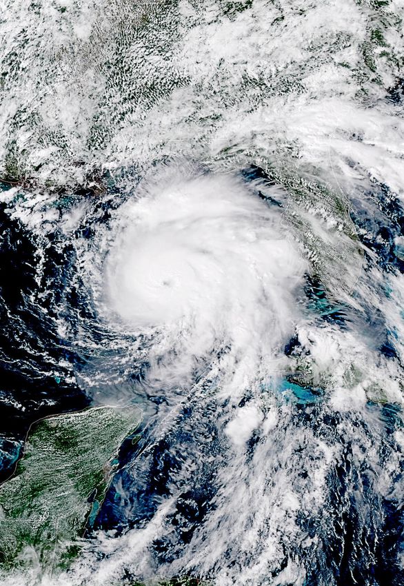
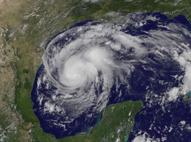
Above: High resolution satellite image of Hurricane Harvey
approaching the Middle Texas Coast. Image--NOAA
Above: Historical perspective of hurricane landfalls in Texas
since 1851. Image -- NOAA
Since 1851, 64 hurricanes have struck the Texas coast.
That is one every three years on average.
2020 South Texas 39
Hurricane Guide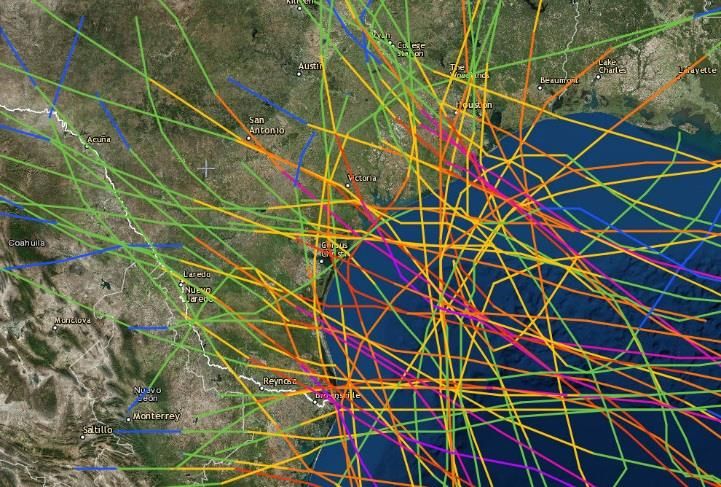
Storm Surge
Storm Surge Defined
Storm surge is an abnormal rise of water generated by a storm, over and above the predicted
astronomical tides. This rise in water level can cause extreme flooding in coastal areas resulting in
storm tides reaching up to 20 feet or more in some cases. Along the Texas coast, these flood waters
can penetrate far inland depending on the elevation of the land. If the storm tide is greater than the
land elevation (even if well inland) then storm surge flooding will be possible.

Storm Surge Can Be Deadly! Here are 6 Tips to be Ready
   1. Storm surge flooding is often the greatest       4. Many Gulf Coast areas are vulnerable to
      threat to life and property from a hurricane.       storm surge including areas many miles
      It poses a significant threat for drowning. A       inland from the coastline depending on
      mere six inches of fast-moving flood water          elevation of the coastal plain. Find out today
      can knock over an adult. It takes only two          if you live in a storm surge zone (see pages
      feet of rushing water to carry away most            5-7 in this guide).
      vehicles.                                        5. Storm surge can occur before, during and
   2. Storm surge can cause water levels to rise          after the center of the storm passes through
      quickly and flood large areas in just minutes,      an area, and can sometimes cutoff
      and you could be left with no time to take          evacuation routes. The water can also rise
      action if you haven’t already evacuated as          well in advance of the coming storm, in
      instructed.                                         some cases 36 hours or greater. When an
   3. Storm surge is not dependent on the Saffir-         evacuation is ordered, do not wait until the
      Simpson Hurricane Wind Scale. Hurricane             last minute to leave.
      categories are based only on winds and do        6. During the peak of a storm surge event, it is
      not account for storm surge. Any wind               unlikely that emergency responders will be
      category can all cause life-threatening storm       able to reach you if you are in danger.
      surge.

                                    For more information about storm surge,
                                  please visit the new NHC Storm Surge Video:
                               https://www.youtube.com/watch?v=bBa9bVYKLP0

2020 South Texas                                                                                    49
Hurricane Guide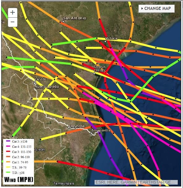
Storm Surge
Corpus Christi

Above: This map shows the height above ground the water could reach and depicts the reasonable worst-case
scenario from storm surge flooding.

‘‘The greatest potential for loss of life related to a
hurricane is from the storm surge.”
                               -National Hurricane Center

2020 South Texas                                                                                            59
Hurricane Guide
Storm Surge
Rockport/Port Aransas

Above: This map shows the height above ground the water could reach and depicts the reasonable worst-
case scenario from storm surge flooding.

2020 South Texas                                                                                        69
Hurricane Guide
Storm Surge
Port Lavaca

Above: This map shows the height above ground the water could reach and depicts the reasonable worst-
case scenario from storm surge flooding.

    Want to see more high resolution storm surge maps?
         Visit: National Storm Surge Hazard Maps

2020 South Texas                                                                                        79
Hurricane Guide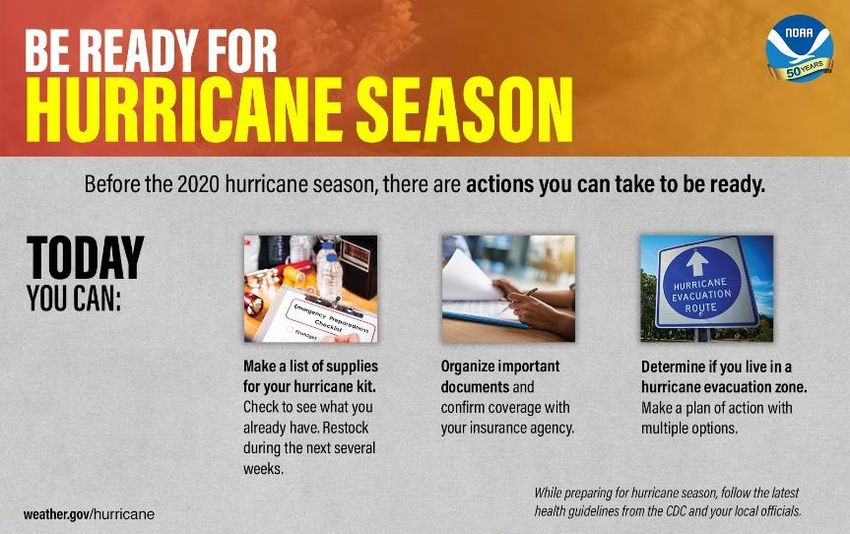
Inland Flooding
There are numerous examples of significant
flooding caused by land-falling tropical cyclones
in Texas. Storms with a slow forward motion are
the most dangerous as heavy rains persist for a
longer period of time.

Five Practical Ways to Protect
Yourself and Others From the
Dangers of Inland Flooding
  Protect Your Personal Documents
  and Special Items
      • Store valuables in plastic tubs with locking tops
      • In case of an evacuation, you should be able to
        secure and move all your valuables within 15 minutes

  Buy Flood Insurance – A Plan for Replaceable Items
      • The National Flood Insurance Program (NFIP) is available from an insurance agent or the
        NFIP
      • For more information see www.floodsmart.gov

  Flood Proof Your Home – Take Steps to Minimize Flood Damage
      • Shut off the main circuit breaker to prevent appliances from short circuiting and
        eliminate the threat of electrocution
      • Raise outside air conditioning units onto platforms above ground level
      • Store rarely used or expensive items in the attic or on high shelves

  Develop a Family Flood Plan
      • Develop a plan of action to keep from panicking or withdrawing during an emergency
      • Have an evacuation route and alternatives planned in the event you are asked to
        evacuate
      • Communicate your plans with friends or family outside of your home area
      • Battery powered radios or televisions can be used in the event of a power outage

  Never Drive on Flooded Roads
      • Driving into flooded roadways puts your life and the lives of others at risk
      • Unless told to evacuate, you are probably safest staying at your current location
      • If you encounter flood waters when driving, Turn Around, Don’t Drown!

2020 South Texas                                                                             89
Hurricane Guide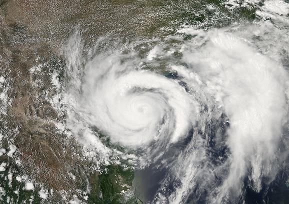
Tornadoes and Destructive Winds
Tropical cyclones also produce tornadoes.
These tornadoes most often occur in
thunderstorms embedded in rain bands well
away from the center of the hurricane;
however, they can also occur near the eyewall.
Tornadoes produced by tropical cyclones are
relatively weak and short-lived, but still pose a
threat.

Hurricane force winds of 74 mph or more can
destroy buildings, mobile homes, trees and
power poles. Debris such as signs, roofing
material, siding, and small items left outside
become flying missiles in a hurricane. The
strongest winds occur in a region of the             Above: Damage to the community of Copano Village in Aransas
hurricane called the eyewall. Wind gusts in          County, TX in the wake of Hurricane Harvey in 2017.
the right side of the eyewall are the most
destructive. Hurricane force winds can be
felt as far as 150 miles from the coast

                                           MOBILE HOME RESIDENTS MUST EVACUATE!
                                            •   No mobile home or manufactured home - no matter
                                                how new it is - can provide safe shelter from hurricane
                                                force winds.
                                            •   Straps or other tie-downs will not protect a mobile
                                                home from the high winds associated with a hurricane.
                                            •   Mobile home residents must evacuate when told to do
                                                so by local authorities.
 Above: Destroyed mobile home in Refugio
 County, TX during Hurricane Harvey in
 2017.

2020 South Texas                                                                                              99
Hurricane Guide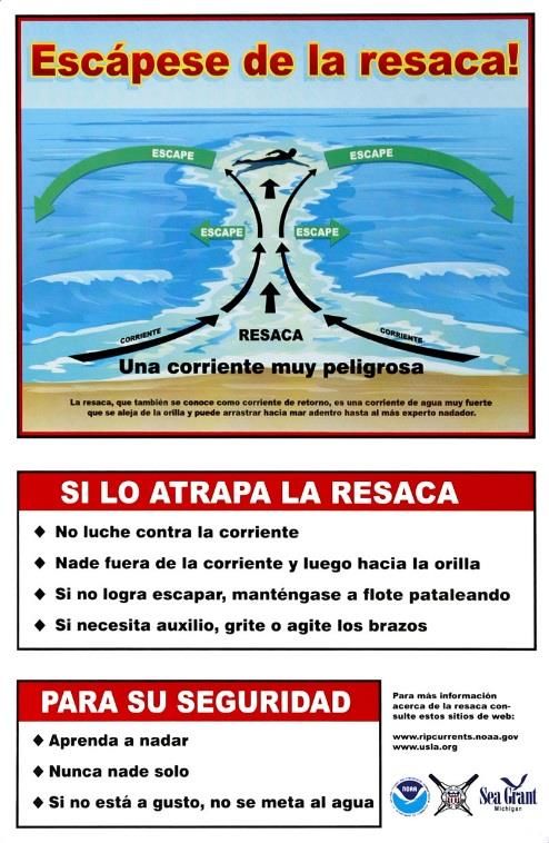
Hurricane Preparation
 Home Preparation
 Elevation Matters
   • Know the elevation of your
     home! Are you in a flood
     and/or evacuation zone?

 Mobile Homes
   • Check tie-downs for rust or
     breakage.
   • Residents of mobile homes
     must evacuate when told to
     do so!!

 Landscaping
   • Trim trees, shrubbery and
     dead limbs, especially ones                 Above: This well built home in the community of Copano
                                                 Village in Aransas County, TX survived Hurricane
     close to your home.                         Harvey in 2017.
   • Repair or replace broken or damaged fences.

 Roofing
   • Inspect the roof for loose tiles, shingles or debris. Consider replacing old or damaged
     shingles with new ones rated for hurricane force winds.
   • Clear loose and clogged rain gutters and downspouts.

 Doors
   • Reinforce garage doors and tracks or replace with a hurricane tested door.
   • Reinforce double entry doors with heavy duty foot and head bolts.
   • Use a security dead bolt with a one inch minimum bolt length.

 Windows
   • If possible, install tested/manufactured hurricane shutters.
   • Inspect existing shutters to ensure they are in good working order.
   • Alternative: Use 5/8” or greater exterior grade plywood secured by 2 1/2” screws and/
     or special clips. Obtain wood and fasteners, cut wood to size, pre-drill holes and place
     anchors on homes.

          For more information on home preparedness, please
          visit the Federal Alliance for Safe Homes (FLASH) at:
                          http://www.flash.org/

2020 South Texas                                                                                      109
Hurricane Guide
Special Preparedness Considerations
This hurricane season may require adjustments to preparedness actions based on the latest health
and safety guidelines from the Centers for Disease Control (CDC) and local officials:
Additional emergency supplies may be needed for preparedness kits. Consider adding the
following items based on your individual needs:
• Cloth face coverings (for each person ages 2 and above)
• Disinfectants like soap, hand sanitizer, or disinfecting wipes
Listen to local officials on questions related to how you may need to adjust any evacuation
plans. Contact information for your city or county is available on pages 29-30.
The CDC recommends if you need to go to a public shelter, bring the following items:
• At least two (2) cloth face coverings (for each person ages 2 and above)
• Hand sanitizer, if possible
Health Resources
• Centers for Disease Control (CDC): www.cdc.gov
• Federal Emergency Management Agency (FEMA): https://www.ready.gov/hurricanes
• Texas Department of State Health Services: https://www.dshs.texas.gov/
• Corpus Christi - Nueces County Public Health District: https://www.cctexas.com/health
• Victoria County Public Health Department: https://www.vcphd.org/
• Goliad County Health Advisories: http://www.co.goliad.tx.us/page/Health%20AdvisorIes
• Kingsville-Kleberg County Health Department:
http://www.cityofkingsville.com/departments/health-and-social-services/
• San Patricio County Emergency Management: https://sanpatem.com/
2020 South Texas 119
Hurricane GuideAdditional Preparation
Business and Employee Preparation
• Identify and protect vital records. Backup and store key files off site.
• Protect electronic equipment from possible water damage.
• Have extra cash and blank checks in case extra money is needed after the storm.
• Develop a 24-hour emergency contact with phone numbers of key employees.
• Set up telephone numbers for employees to check in and receive company information.
• Establish a temporary location for business operations in case your facility is damaged.
• Give employees enough time to secure their homes and families.
• Consider paying employees before they leave to prepare their homes.
Marine Preparations
• Check with the manufacturer for proper ways to secure your boat during a storm.
• Purchase necessary hurricane materials such as additional mooring lines, crew anchors,
fenders, fender boards, chafing gear, and anchors.
• Safe storm moorings should consist of good condition ropes of sufficient diameter and
length, with at least three or four substantial anchor points.
• Do not moor parallel to bank. Receding tides often capsize boats in this type of
anchorage.
Preparing for Your Pet’s Safety
• Your pet should be part of your overall hurricane preparation plans. Below are a few
important things to help you prepare:
• Make sure your pet’s vaccinations are current and have proof they are current. DO NOT
assume that a public shelter or hotel will accept your pet.
• Be sure to have a current photo of your pet.
• Each animal should have a properly sized pet carrier. The carrier should be large enough
for the animal to stand up and turn around.
• Pack enough food and bottled water for the duration of your evacuation. DO NOT let
your pet eat food or drink water from outside that may have become contaminated.
• Be sure to pack all medications your pet may need along with a muzzle, collar, leash,
paper towels, and trash bags.
• Make sure your pet has a proper ID collar.
2020 South Texas 129
Hurricane GuideInsurance Tips
Before the Storm
• New and existing policies will not be written or modified when a storm nears the Gulf of
Mexico.
• Make sure you fully understand what perils are covered and excluded in your policy.
• Make sure your coverage is adequate to replace your home and contents in today’s
dollar.
• Determine whether your policy covers additional living expenses for a temporary
residence if you are unable to live in your home because of damage from a disaster.
• Before hurricane season, prepare detailed written and/or photographic inventory of your
home’s contents and store it in a safe place with your policy.
• If your insurance company does not cover flood or windstorm perils, ask about coverage
through the Texas Windstorm Insurance Association or the National Flood Insurance
Program.
After the Storm
• Give prompt written notice to your insurance company.
• Photograph or videotape damaged structures and all damaged property. Make a list of
damaged or lost items.
• DO NOT throw out damaged property before your adjuster has inspected the debris
unless it is a health hazard or impedes local cleanup.
• Protect your property from further damage.
• Keep an accurate record of temporary repair and living expenses if a loss of use is
suffered.
Important
• National Flood Insurance Program
www.floodsmart.gov
Online • Texas Windstorm Insurance Association
www.twia.org
Insurance Consumer help line 800-788-8247
• Texas Department of Insurance
Information www.tdi.texas.gov
Consumer Help Line 800-252-3439
2020 South Texas 139
Hurricane GuideContact Info and Supplies
Your local Texas Chapter of the American
Red Cross recommends that you have the
following items in your Hurricane Supply
Kit. Do not forget to have a family
meeting before hurricane season and
review your communication information
and evacuation plan. Make sure the
contact information such as home, work,
school, cell phone numbers, and your
“Out of Town” contact person’s
information is current.
Emergency Contact Information
Out of Town Contact Address: ________________________________________
Out of Town Contact Phone Number: ___________________________________
Work Telephone Number: ____________________________________________
Cell Number/Spouse Cell Number: _____________________________________
Children Cell Number: ______________________________________________
School Telephone Number: __________________________________________
Doctor Telephone Number: __________________________________________
Bank/Credit Card Telephone Number: __________________________________
Insurance Company Information: ______________________________________
24 hour number to
call for assistance
1-800-RED CROSS
(1-800-733-2767)
2020 South Texas 149
Hurricane GuideHurricane Supply Kit
Your chapter of the American Red Cross recommends that
you have the following items in your Hurricane Supply Kit.
• At least a 7-day supply of non-perishable food and water. One gallon of water per
person per day is recommended
• Battery powered portable television or radio with extra batteries
• Flashlight with extra batteries
• First Aid kit and manual
• Sanitation and hygiene items such as instant hand sanitizing gel, moist
towelettes, toilet paper, and feminine hygiene products
• Whistle
• Kitchen accessories, cooking utensils, and manual can opener
• Cash
• Extra clothing, blankets, and sleeping bags
• Matches in a waterproof container
• Photocopies of identification, insurance, prescriptions, household inventory, credit
cards, and your latest utility bill
• CD or photocopies of important documents such as birth/marriage
certificates and titles
• Prescription medications, eyeglasses, contact lens solution, and hearing aid
batteries
• Formula, baby food, diapers, and pacifiers
• Pet carriers, leashes, shot records, and food for each animal evacuating with you
• A good map showing county roads and highways
• Tire repair kit, booster cables, pump, and flares
• White distress flag
• Toys and games for children
• List of family phone numbers and addresses outside the area
2020 South Texas 159
Hurricane GuideHurricane Names
Have you ever wondered how a hurricane gets its name? The National Hurricane Center actually
does not name tropical storms and hurricanes. Instead, the names are established by the World
Meteorological Organization and then rotated every six years. If a storm is too deadly or costly,
the name will be retired and never be used again.
2020 2021 2022 2023 2024
Arthur Ana Alex Arlene Alberto
Bertha Bill Bonnie Bret Beryl
Cristobal Claudette Colin Cindy Chris
Dolly Danny Danielle Don Debby
Edouard Elsa Earl Emily Ernesto
Fay Fred Fiona Franklin Francine
Gonzalo Grace Gaston Gert Gordon
Hanna Henri Hermine Harold Helene
Isaias Ida Ian Idalia Isaac
Josephine Julian Julia Jose Joyce
Kyle Kate Karl Katia Kirk
Laura Larry Lisa Lee Leslie
Marco Mindy Martin Margot Milton
Nana Nicholas Nicole Nigel Nadine
Omar Odette Owen Ophelia Oscar
Paulette Peter Paula Philippe Patty
Rene Rose Richard Rina Rafael
Sally Sam Shary Sean Sara
Teddy Teresa Tobias Tammy Tony
Vicky Victor Virginie Vince Valerie
Wilfred Wanda Walter Whitney William
For a printable hurricane tracking map, please click on this link.
2020 South Texas 169
Hurricane GuideForecast Information
Latest Weather Information
National Weather Service
www.weather.gov/corpuschristi
24 Hour Phone Recording:
361-289-1861
National Hurricane Center
@NWSCorpus www.hurricanes.gov
Graphical Tropical Weather
Outlook
• This NHC product provides an overview of
all tropical cyclone activity and indicates
areas of interest that have potential for
tropical cyclone development.
NHC Forecast Advisory
• Most recent position for a storm along with
all coastline watches and warnings.
Includes a 3 or 5 day track with error cone.
• Error cone represents a 5 year average
error. Storms only stay within the error
cone 67% of the time.
• DO NOT focus too closely on the exact
track forecast – the little back line.
• Impacts may occur well outside the cone.
2020 South Texas 179
Hurricane GuideForecast Information
Hurricane Watch/Warning Do you have Wireless Emergency
Tropical Storm Watch/Warning Alerts (WEA) turned on for your
• A Hurricane Watch means hurricane phone?
conditions are possible in your area within WEAs are sent by authorized government
48 hours. agencies through your wireless provider and
• A Hurricane Warning means hurricane alert to extreme weather.
conditions are likely within your area within
WEAs include a special tone and vibration, both
36 hours.
repeated twice. Check your wireless phone’s
• A Tropical Storm Watch means tropical
menu settings to ensure WEAs are enabled:
storm conditions are possible in your area
within 48 hours. • Android: Settings > Connections > More
• A Tropical Storm Warning means tropical Connection Settings > Wireless Emergency
storm conditions are likely within your area Alerts
within 36 hours. • Apple: Settings > Notifications >
• If you are under a hurricane watch or Government Alerts
warning, prepare for possible evacuations
and evacuate if instructed to do so.
(2) Graphical depiction of peak storm
surge Inundation values along the U.S.
Gulf & Atlantic coasts, Puerto Rico,
New for 2020 Season: and the U.S. Virgin Islands
• Values represent the peak height water
(1) Addition of a 60-hour forecast
could reach above normally dry ground
point somewhere in the specified area
2020 South Texas 189
Hurricane GuideForecast Information
Time of Arrival Graphics Storm Surge Watch/Warning
• A storm surge watch is the possibility of
• These maps are useful planning tools. life-threatening storm surge within 48
• One map shows the earliest reasonable hours.
arrival time of tropical storm force winds. • A storm surge warning is the danger of life-
• A secondary map will show the most likely threatening storm surge within 36 hours.
arrival time of tropical storm force winds. • If you are located in a storm surge watch or
warning, you are not safe. Take action to
protect your life. Promptly follow
evacuation and other instructions from
emergency management officials.
Potential Storm Surge Flooding
Map
Hurricane Threats and Impacts
• If a hurricane is threatening your
• This product issued by local NWS offices
community, go to hurricanes.gov and view
will summarize potential impacts expected
the potential storm surge flooding map,
from a tropical cyclone.
which will show the reasonable-worst case
• Click on the colored area and text that
scenario from storm surge inundation for
describes potential impacts will display.
your area.
• www.weather.gov/srh/tropical?office=crp
2020 South Texas 199
Hurricane GuideLocal Tropical Webpage
NWS Corpus Christi Tropical Webpage
• One-Stop Shop for all tropical related • Satellite and Radar data is always available.
forecast information, tailored to each
forecast area along U.S. coastline. • Preparedness tab is always available and
provides quick access to local evacuation
• Active Storms tab appears when NHC maps, preparedness guides, and videos.
initiates Tropical Cyclone advisories.
• Scrolling down the page provides access to
• Local Products tab also becomes active when NHC products related to each active storm
WFO Issues Watches/Warnings for local area. and WPC rainfall products.
2020 South Texas 209
Hurricane GuideFinal Checklists
Actions to Take When a Storm is in the Gulf
• Listen frequently to radio, TV, or NOAA weather radio for bulletins and forecasts of the
storm’s progress.
• Double check items in your emergency supply kit.
• Fuel and service your vehicles.
• Inspect and secure mobile home tie-downs.
• Board up windows (if shutters do not exist) in case storm moves quickly and you have
to leave!
TAPE PROVIDES NO PROTECTION!
• Store lawn furniture and other loose, light weight objects, such as garbage cans and
garden tools.
• Garage or store vehicles that are not being used.
• Follow instructions issued by local officials.
EVACUATE IMMEDIATELY IF ORDERED TO DO SO!
Final Actions to Take if Leaving
• Turn off propane tanks.
• Unplug small appliances.
• Empty refrigerator and freezer.
• Turn off utilities if ordered to do so.
• Lock home securely.
• Take pets with you.
U.S. Navy
Final Actions to Take if Staying
• Close storm shutters.
• Notify family members of your evacuation plans.
• Lower water level in swimming pool by one foot.
• Turn refrigerator or freezer to coldest setting and open only if necessary.
(25 pounds of dry ice will keep a 10-cubic foot freezer below freezing for 3-4 days.)
• Follow instructions from emergency managers and be prepared to turn off utilities if
ordered to do so.
• Board up remaining doors, brace garage door, and remain inside. Stay away from
boarded up windows.
• Take refuge in a predetermined safe room, such as an interior closet, bathroom, or
hallway.
• DO NOT EXPECT EMERGENCY RESPONDERS TO BE OF ANY ASSISTANCE DURING
A LANDFALLING HURRICANE!
2020 South Texas 219
Hurricane GuideHurricane Surf and Rip Currents
Hurricane Surf
Along with Along with
big surf big strong
come surf come strong
rip currents.rip currents.
Rip currentsRiparecurrents
the are
leading surfthe leading
hazard for surf hazard for all
all beach
beachingoers
goers and result over and
100 result in over
drownings 100every drownings
year in the every year in the
United
United States. The States.
strength The
andstrength and
size of rip
size of rip currents arecurrents
related are related
to the surf
to the size of size and
of the surf and wave
wave
period. Rip period.
currentsRip currents typically
typically
form at theform at theinlow
low spots thespots in the
surf, at the surf,
breaksat the breaks in the
in the
sandbars, andsandbars, and near
near jetties and jetties and
piers. piers.
FEMA Jocelyn Augustino
Rip Currents
If caught in a rip current,
don’t panic, but swim parallel
to the shore. The current is
usually only about 50 feet
wide and you should be able
to swim out of it. At that
point, you can swim back to
shore. If you are still unable
to reach the shore, draw
attention to yourself: face the
shore, wave your arms, and
yell for help.
2020 South Texas 229
Hurricane GuideStudent Information Checklist
• Assure that all contact information and emergency contact information is
accurate with your campus’ registrar’s office.
• If your campus offers an emergency management communication system, register
as a user of the system.
• Plan your method of evacuation and your destination before a storm enters the gulf.
• Monitor local radio and TV stations for updates.
• Contact your campus Student Affairs Office if you need assistance with evacuation.
• If you require any assistance due to a disability-related accommodation, please
contact your campus Disability Services Office to make necessary arrangements.
• Communicate with your family regarding status and location
• If your campus is evacuating, you will not be allowed to remain on-campus and it
is highly recommended that you leave the city. Do not go to a coastal location.
• Take your driver’s license, student I.D. card, and a copy of your housing lease as
well as medical insurance cards and other important documents when you
evacuate.
• If you bank with a local bank or credit union whose infrastructure may be damaged
by the storm, withdraw some funds as you may not have access to them once you
leave the area.
• International students must take passports with US student visa inside, I-20, I-
94, student I.D. and class schedule.
• If using personal transportation, take as many of your valuable or irreplaceable
items as you are able.
• If driving, make sure all roads that you are driving are open and safe. You can call
the Department of Transportation at 1-800-452-9292 or check on-line for
conditions at www.drivetexas.org
• Follow baggage limits if participating in an assisted evacuation program.
• Take a 30-day supply of medications in original pharmacy containers.
• Make a record of any valuables left behind (description, serial numbers, etc).
Take pictures of all belongings.
• If you are evacuating to a shelter, make appropriate arrangements for pets.
Most shelters do not accept pets.
• Do not plan to return to campus until an all-clear is given (monitor media and
campus web-site).
2020 South Texas 239
Hurricane Guide2020 South Texas 249 Hurricane Guide
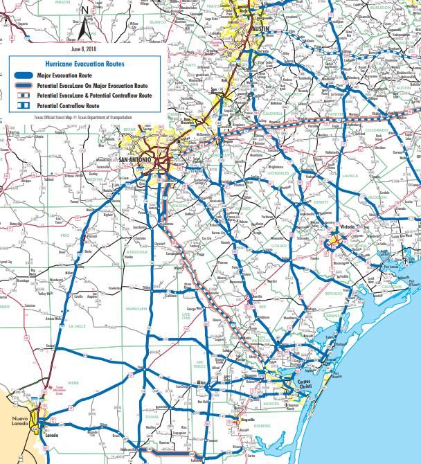
Evacuation Routes
 Evacuees need to consider the
 projected path of the
 hurricane when choosing an
 evacuation route
 and destination. When
 evacuating, be sure to check
 local weather and highway
 conditions before departing.
 When local authorities order
 an evacuation of your area,
 leave immediately!

 Final Actions before
 Evacuating
   • Follow evacuation orders
     provided by your local
     officials.
   • Once the evacuation
     order has been given,
     LEAVE IMMEDIATELY!
   • Take your Hurricane
     Supply Kit with you.
   • Leave as early as possible
     to avoid heavy traffic and
     hazardous weather.

   • Do not stay in a mobile home near the coast under any circumstance.
   • Remember that large boats and travel trailers may not be allowed to cross local bridges
     and causeways once high winds commence.
   • Prepare to stay at your evacuation destination for a week or more, as re-entry into the
     affected area may be restricted.

 Texas Road Information
   •   TXDOT Highway Conditions 1-800-452-9292 or www.drivetexas.org
   •   TXDOT Corpus Christi Office 1-361-808-2660
   •   Emergency Broadcast Information KLUX Radio 89.5 FM
   •   Twitter @TxDOT_CRP

 MORE INFORMATION ON LOCAL EVACUATION                             OR     SHELTER-IN-PLACE
 DIRECTIVES CAN BE FOUND ON PAGES 29-30.

2020 South Texas                                                                               259
Hurricane Guide
Bus Evacuation
Bus Loading Points will open on an as-needed basis. DO NOT go to
Bus Loading Points unless directed to by public officials.
For more information regarding the city of Corpus Christi’s hurricane
evacuation bus assistance plan, please download this PDF.
Corpus Christi San Patricio County
Any RTA Bus Stop San Patricio County Fairgrounds
219 W 5th Street
Evacuation Hub @ Corpus Christi Gym Sinton, TX 78387
3202 Cabaniss Road
Corpus Christi, TX 78415 Aransas Pass Civic Center
700 W Wheeler Avenue
Aransas Pass, TX 78336
Nueces County Kingsville
Richard M. Borchard Regional Fairgrounds Kleberg County Courthouse
1213 Terry Shamsie Boulevard 700 East Kleberg Avenue
Robstown, TX 78380 Kingsville, Texas, 78363
Victoria Port Lavaca
Victoria Community Center Bauer Community Center
2905 East North Street 2300 State Highway 35 North
Victoria, TX 77901 Port Lavaca, TX 77979
Aransas County
Live Oak Learning Center
31 Griffith Drive
Rockport, Texas 78382
2020 South Texas 269
Hurricane GuideReturning Home
IF YOU EVACUATED THE AREA, WAIT FOR AN ALL CLEAR FROM THE CITY OR
COUNTY BEFORE ATTEMPTING TO RETURN TO YOUR HOME. BE PREPARED TO
SHOW PROOF OF RESIDENCE BY HAVING A COPY OF YOUR LATEST UTILITY BILL.
Debris Cleanup
• Cities and counties will publish a schedule
for debris pick-up and removal. Debris
cannot be removed from private property.
• Construction materials, vegetative debris,
household hazardous waste and
household appliances will need to be
placed into separate piles and moved to
the curbside for pick-up.
FEMA Mike Moore
General Cleanup
• Be cautious of structural damage and downed power lines.
• DO NOT attempt to move structural supports or large pieces of debris.
• DO NOT run power generators indoors. Inhalation of carbon monoxide from the
exhaust can cause death. Ensure exhaust is well ventilated.
• DO NOT use open flames indoors.
• Restrict your driving to emergency use only. Road conditions may not be safe until
road debris is cleared.
Water
• Listen for instructions regarding public water supply. Use only bottled, boiled or
treated water until you know that your water supply is safe.
• You can use household chlorine bleach to treat water for drinking or cleaning. Add 1/8
teaspoon of bleach per gallon of clear water or 1/4 teaspoon of bleach per gallon if
water is cloudy. Allow water to stand for 30 minutes before using.
Interior Cleanup
• Disinfect and dry interior buildings and items inside. This will prevent growth of some
bacteria, viruses, mold, and mildew that can cause illness.
• Clean walls, floors, and counter tops with soap and water. Disinfect them with a
solution of 1 cup of bleach to 5 gallons of water.
• Wash all clothes and linens in hot water. Air dry and spray all unwashable items with
disinfectant. Steam clean carpets. Throw away all items touched by water that cannot
be disinfected.
2020 South Texas 279
Hurricane GuideReturning Home
Utility Cleanup
• Check for gas leaks. If you smell or
hear gas leaking, leave
immediately. DO NOT use the
phone or turn on lights in your
home. Call the gas company from
a neighbor’s phone.
• Report any visible damage of
power lines to the electric
company. Turn off power at main
breaker if any electrical equipment
or circuits have been exposed to
water.
• DO NOT connect generators to
your home’s electrical circuits. If a
generator is on line when
electrical service is restored, it can
become a major fire hazard. Also,
line workers working to restore
power will be endangered if a FEMA Greg Henshall
generator is hooked up to the
home’s circuits.
• It is likely that an electric company other than your own will reconnect the lines to your
home; however, they cannot turn the service back on. Only your electric company can
actually turn the power back on to your house.
Sewage Cleanup
• If you suspect water or sewage lines are damaged, do not use your plumbing (toilets,
sinks, etc.). Contact the water company or a plumber for repairs.
• A chemical portable commode can be created by the following:
• Use 5 gallon buckets with tight lids, lined with heavy duty plastic garbage
bags.
• Add kitty litter to the bucket as a disinfectant and deodorizer. Keep lids on
firmly.
• Keep buckets in a cool, dark place. Clean and disinfect buckets immediately.
• Your toilet can also be used by flushing until the bowl has no water. Then, line with
heavy duty trash bags and disinfect with chlorine bleach after each use. Remove waste
to an outside location.
• If significant sewer outages have occurred, instructions for disposal of human wastes
will be announced.
• DO NOT dispose of human waste through your regular trash!
2020 South Texas 289
Hurricane GuideEmergency Information
ARANSAS COUNTY KLEBERG COUNTY
• Rockport Police • County Emergency Management
361-729-1111 361-595-8527
• County Sheriff • County Sheriff
361-729-2222 361-595-8500
• City of Fulton
361-729-5533
LIVE OAK COUNTY
• County Sheriff
BEE COUNTY 361-449-2271
• County Emergency Management
361-621-1550 ext. 1
NUECES COUNTY
www.co.bee.tx.us • County Emergency Management
361-888-0513
• Beeville Police www.co.nueces.tx.us
361-358-8100
• City of Corpus Christi
• County Sheriff 361-826-1100
361-362-3221 Ready Corpus Christi
Facebook: Ready CC
CALHOUN COUNTY Twitter: ReadyCC
• County Emergency Management
361-553-4400 • Port Aransas City Hall
www.calhouncotx.org 361-749-4111
www.cityofportaransas.org
• County Sheriff
361-553-4646 • City of Robstown
361-387-2522
GOLIAD COUNTY www.cityofrobstown.com
• Goliad County Judge • Bishop Police
361-645-3337 361-584-2443
• County Sheriff • Driscoll Police
361-645-3451 361-221-2902
JIM WELLS COUNTY REFUGIO COUNTY
• County Emergency Management • County Emergency Management
361-668-1018 ext. 8 361-526-2820
• Alice Emergency Management • County Sheriff
361-664-3111 ext. 4 361-526-2351
• Jim Wells County Sheriff
361-668-0341
Do Not Call 911 for Non-Emergencies!
2020 South Texas 299
Hurricane GuideEmergency Notes
SAN PATRICIO COUNTY ________________________________________________
• County Emergency
________________________________________________
Management
361-587-3560 ________________________________________________
• Ingleside Police ________________________________________________
361-776-2531
________________________________________________
• Portland Police
361-777-4444 ________________________________________________
• County Sheriff ________________________________________________
361-364-9600
________________________________________________
• Aransas Pass Police
361-758-5224 ________________________________________________
________________________________________________
VICTORIA COUNTY
• City/County Emergency ________________________________________________
Management
________________________________________________
361-580-5770
• Victoria Police ________________________________________________
361-573-3221 ________________________________________________
• County Sheriff ________________________________________________
361-575-0651
________________________________________________
________________________________________________
Additional Information
• US Department of ________________________________________________
Homeland Security ________________________________________________
www.ready.gov
________________________________________________
• American Red Cross
www.redcross.org ________________________________________________
(enter zip code for local office)
________________________________________________
24 hour number to call for assistance
1-800-RED CROSS ________________________________________________
(1-800-733-2767)
________________________________________________
________________________________________________
________________________________________________
________________________________________________
________________________________________________
________________________________________________
2020 South Texas 309
Hurricane GuideEmergency Notes ________________________________________________ ________________________________________________ ________________________________________________ ________________________________________________ ________________________________________________ ________________________________________________ ________________________________________________ ________________________________________________ ________________________________________________ ________________________________________________ ________________________________________________ ________________________________________________ ________________________________________________ ________________________________________________ ________________________________________________ ________________________________________________ ________________________________________________ ________________________________________________ ________________________________________________ ________________________________________________ ________________________________________________ ________________________________________________ ________________________________________________ ________________________________________________ ________________________________________________ ________________________________________________ ________________________________________________ ________________________________________________ ________________________________________________ ________________________________________________ ________________________________________________ ________________________________________________ ________________________________________________ ________________________________________________ ________________________________________________ ________________________________________________ ________________________________________________ ________________________________________________ ________________________________________________ ________________________________________________ ________________________________________________ ________________________________________________ ________________________________________________ ________________________________________________ ________________________________________________ ________________________________________________ ________________________________________________ ________________________________________________ ________________________________________________ ________________________________________________ ________________________________________________ ________________________________________________ ________________________________________________ ________________________________________________ ________________________________________________ ________________________________________________ ________________________________________________ ________________________________________________ 2020 South Texas 319 Hurricane Guide
Hurricane Recurrence Period
 Does the Middle Texas Coast Experience a Tropical Cyclone Every
 Three Years?
 This August marks three years since the Mid-
 Texas Coast suffered a direct strike by
 Hurricane Harvey. A Category 4 hurricane at
 landfall, Harvey was the strongest storm in
 these parts since Hurricane Bret (another
 Category 4) made landfall near Baffin Bay in
 1999. Historically, any 50-mile stretch of
 Texas Coastline averages one landfalling
 hurricane about every six years. While this
 may not sound impressive for a coastline that
 spans over 350 miles, consider that the
 impacts of some hurricanes can extend for
 hundreds of miles beyond their point of
 landfall! Devastating floods, storm surges,
 damaging winds, and tornadoes can all occur
 well away from the eye of a hurricane. With
 this fact in mind, let’s see if there’s any truth
 to whether or not tropical cyclones affect
 (either directly or indirectly) the Middle Texas
 Coast every three years.
                                                     Map of all tropical cyclones since 1851 that dealt impacts to
 Records of Texas hurricanes and tropical            the Middle Texas Coast.
 storms extend back to the 1850s. Although
 both the reliability and detail of the oldest
 data sets are nowhere near as robust
 compared to modern times, this data is still
 useful. This brief study compares the
 occurrence of tropical storms and
 hurricanes that passed within 100 miles of
 any point along the Middle Texas Coast
 from 1851 to 2019. What follows is a list of
 questions and answers based on the data.

 Does the Middle Texas Coast
 experience a hurricane once
 every three years?
 No. In reality, we average one hurricane
 about every six years.                              Radar Image of Hurricane Carla in 1961.

2020 South Texas                                                                                                329
Hurricane Guide
Hurricane Recurrence Period Do major hurricanes (Category 3-5) along the Middle Texas Coast occur three years apart from each other? Sometimes, but not always. Interestingly, this 3-year recurrence pattern did occur in the following sets of years: 1916 and 1919, 1942 and 1945, 1958 and 1961, 1967 and 1970, and lastly 1980 and 1983. However, these years all saw major hurricanes that were not followed by another major hurricane 3 years later: 1875, 1880, 1886, 1900, 1909, 1915, 1932, 1933, 1971, and 1999. The last major hurricane to affect the Middle Texas Coast was Harvey in 2017. Are we likely to see another major hurricane make landfall here Satellite Image of Hurricane Celia in 1970. in 2020? No one knows at this time. However, you need to be ready for any hurricane! Are there periods when hurricanes are more likely to affect Texas? There are patterns when hurricanes occur more frequently than other years. Research has shown that active hurricane cycles last about 11 years with an average of 8 landfalling hurricanes in Texas. Quieter hurricane periods last around 14 years while only about 2 hurricanes make landfall in Texas. The last active cycle occurred from roughly 2003 to 2014. However, even in quiet periods extremely destructive Satellite Image of Hurricane Dolly in 2008. hurricanes can still occur on the Texas Gulf Coast! 2020 South Texas 339 Hurricane Guide
National Weather Service
    WFO Corpus Christi, TX
    426 Pinson Drive
    Corpus Christi, TX 78406
    Phone: 361-289-0959
    Fax: 361-289-7823          @NWSCorpus

                                      www.weather.gov/corpuschristi

    BECOME AN AMBASSADOR TODAY!
                   Visit: www.weather.gov/wrn/

2020 South Texas
Hurricane Guide                                                   9
Guía Oficial de Texas
PARA LA TEMPORADA
DE HURACANES
2019
¿ESTÁ USTED
PREPARADO?
WEATHER.GOV/CORPUSCHRISTI
Guía de Huracanes
2019 Sur de Texas 9Carta a los Residentes Residentes del Sur de Texas, La temporada de huracanes se acerca y debemos estar preparados. De hecho, históricamente 14 huracanes han impactado las costas del estado de Texas durante el mes de junio, así que es importante prepararse antes del comienzo de la temporada, la cual inicia el 1ero de junio. Tal y como vimos tras el paso de Harvey, los huracanes pueden resultar devastadores y muchos residentes todavía están intentando recuperarse dos años después del paso de esta tormenta. Los huracanes traen consigo una multitud de peligros, incluyendo mortíferas marejadas ciclónicas, inundaciones y tornados. Estas fuerzas destructivas podrían desplazarlo a usted y su familia de su hogar durante meses o años. Es por esto que los residentes deben tomar la preparación para los huracanes muy seriamente. Esta guía actualizada le puede ayudar a usted y a su familia a prepararse. Aprenda qué puede hacer antes, durante y luego del paso de una tormenta. Su plan debe incluir las preparaciones para su hogar, colección de suministros, verificación de su póliza de seguros (la cual debe estar al día), y la planificación en caso de tener que evacuar su localidad. Existen muchas organizaciones que le pueden ayudar a prepararse. La Alianza Federal para las Casas Seguras (FLASH por sus siglas en inglés, FLASH.org) contiene una gran cantidad de información sobre cómo preparar su hogar antes del impacto de una tormenta. Si usted ha de necesitar asistencia, simplemente llame al 2-1-1 para registrarse en el Registro de Asistencia de Emergencias del Estado de Texas. Puede encontrar más información sobre estos grupos y varios otros en esta guía. No se distraiga con las perspectivas disponibles para la temporada de huracanes. Es muy importante estar totalmente preparado cada temporada. Una vez se forme una tormenta, obtenga el pronóstico oficial a través del Servicio Nacional de Meteorología (NWS por sus siglas en inglés) y los medios de comunicación locales, y siga las sugerencias de los oficiales locales. ¡Tome este tiempo y asegúrese que usted y su familia estén preparados! ¡Espero que se mantenga seguro durante esta temporada de huracanes! Sinceramente, John Metz Meteorólogo de Coordinación y Aviso Servicio Nacional de Meteorología Corpus Christi, Texas Guía de Huracanes 29 2019 Sur de Texas
Sobre los Huracanes
                                                                       Los huracanes se forman
                                                                       sobre aguas cálidas como
                                                                       las que encontramos en
                                                                       el Golfo de México. La
                                                                       temporada de huracanes
                                                                       comienza el 1ero de junio y
                                                                       termina el 30 de noviembre.
                                                                       El peligro máximo para
                                                                       la costa de Texas ocurre
                                                                       entre los meses de agosto
                                                                       a septiembre, pero estos
                                                                       pueden y han azotado
                                                                       las costas de Texas en
                                                                       cualquiera de los meses de
                                                                       la temporada de huracanes.

   Arriba: Imagen satelital de alta resolución del Huracán Harvey
   a medida que se acercaba a la Costa Central de Texas. Imagen—NOAA

   Arriba: Perspectiva histórica de los huracanes que han
   hecho su entrada en Texas desde 1851. Imagen—NOAA

 Desde 1851, 64 huracanes han azotado las costas de
 Texas. Esto indica un promedio de un huracán cada tres
 años.
Guía de Huracanes                                                                                39
2019 Sur de Texas
Marejadas Ciclónicas
Marejadas Ciclónicas
La marejada ciclónica es un crecimiento anormal por encima del nivel del agua de la marea astronómica
predeterminada generado por una tormenta. Las marejadas ciclónicas no deben ser confundidas con las
mareas de la tormenta, ya que estas últimas se definen como el crecimiento en el nivel del agua debido a
una combinación de la marejada ciclónica y la marea astronómica. Este crecimiento en el nivel del agua
puede causar inundaciones extremas en las áreas costeras, lo cual puede resultar en mareas de tormenta
que pueden alcanzar los 20 pies o más de altura en algunos casos. En las costas de Texas las inundaciones
pueden penetrar costa adentro en algunos casos dependiendo de la elevación del terreno. Si la marea de la
tormenta es mayor que la elevación del terreno (incluso si se encuentra costa adentro) entonces es posible
que ocurran inundaciones debido a la marejada ciclónica.
¡Las Marejadas Ciclónicas Pueden Ser Mortales!
Aquí 6 Consejos Para Estar preparados
1. Las inundaciones debido a las marejadas ciclónicas vulnerables a las marejadas ciclónicas, incluyendo
representan usualmente la mayor amenaza a la vida y áreas localizadas a muchas millas costa adentro
la propiedad en un huracán. Estas presentan un gran dependiendo de la elevación del terreno en el plano
riesgo de ahogamientos. Tan solo 6 pulgadas de costero. Descubre hoy si resides en una zona de
agua en movimiento puede derribar a un adulto. Se evacuación (vea las páginas 5-7 de esta guía).
necesitan tan sólo dos pies de agua corriendo para 5. Las marejadas ciclónicas pueden ocurrir antes,
llevarse consigo la mayoría de los vehículos. durante o luego del paso del centro de la tormenta
2. La marejada ciclónica puede generar un rápido por un área, y puede dejar intransitable las rutas de
incremento en el nivel del agua y causar inundaciones evacuación. El agua también puede incrementar con
en áreas grandes en tan solo unos minutos, y puede mucha anticipación al paso de la tormenta, en
dejar a los residentes sin el tiempo suficiente para algunos casos 36 horas o más con anterioridad.
evacuar el área si no lo hizo cuando le fue indicado. Cuando se le ordene evacuar su área, no espere hasta
3. Las marejadas ciclónicas no son dependientes de la el último momento para hacerlo.
Escala de Vientos de Huracán de Saffir-Simpson. Estas 6. Durante el pico del evento de las marejadas
categorías están basadas en los vientos del huracán ciclónicas, es improbable que los oficiales de manejo
solamente y no toman en consideración la marejada de emergencias puedan alcanzarlo si se encuentra en
ciclónica. Cualquier ciclón tropical, peligro.
independientemente de su categoría, puede causar
marejadas ciclónicas que amenacen la vida.
4. Muchas áreas en las costas del Golfo de México son
Para más información sobre las marejadas ciclónicas vea el nuevo video
sobre las Marejadas Ciclónicas del Centro Nacional de Huracanes (CNH):
https://www.youtube.com/watch?v=bBa9bVYKLP0
Guía de Huracanes 49
2019 Sur de TexasMarejadas Ciclónicas
Corpus Christi
Arriba: Este mapa muestra ambos, la altura por encima de la tierra la cual el agua podría alcanzar y el peor
scenario posible debido a inundaciones causadas por las marejadas ciclónicas.
“De los peligros asociados a los huracanes, las
marejadas ciclónicas son la principal causa de pérdida
de vidas.”
-Centro Nacional de Huracanes
Guía de Huracanes 59
2019 Sur de TexasMarejadas Ciclónicas Rockport/Port Aransas Arriba: Este mapa muestra ambos, la altura por encima de la tierra la cual el agua podría alcanzar y el peor scenario posible debido a inundaciones causadas por las marejadas ciclónicas. Guía de Huracanes 69 2019 Sur de Texas
Marejadas Ciclónicas
Port Lavaca

Arriba: Este mapa muestra ambos, la altura por encima de la tierra la cual el agua podría alcanzar y el
peor scenario posible debido a inundaciones causadas por las marejadas ciclónicas.

     ¿Desea ver más mapas de inundación en alta resolución?
       Visite: Mapas Nacionales de Amenazas de Marejadas
                           Ciclónicas

Guía de Huracanes                                                                                         79
2019 Sur de Texas
Inundaciones Tierra Adentro
Existen numerosos ejemplos de inundaciones
significativas causadas por ciclones tropicales en
Texas. Las tormentas que tienen un movimiento
lento son las más peligrosas ya que las lluvias
fuertes persisten durante un periodo de tiempo
más largo.
Cinco Maneras Prácticas para Protegerse
Usted y a Otros de los Peligros de las
Inundaciones Tierra Adentro
Proteja sus Documentos Personales y
Artículos Especiales
• Almacene objetos de valor en contenedores de plástico con los bloqueos de tapa.
• En caso de una evacuación, usted debe ser capaz de asegurar y mover todos sus objetos
de valor en un lapso de 15 minutos.
Compre un Seguro de Inundaciones: Un Plan para las Cosas Remplazables
• El Programa Nacional de Seguros de Inundación (NFIP por sus siglas en inglés) está
disponible por un agente de seguros o por el NFIP.
• Para obtener más información visite la siguiente página web: www.floodsmart.gov
Proteja su Hogar de las Inundaciones: Tome Medidas para Minimizar los
Daños por Inundaciones
• Apague el interruptor principal para prevenir un corto circuito y eliminar la amenaza de
electrocución.
• Eleve las unidades exteriores de aire acondicionado en plataformas por encima del nivel
del suelo.
• Almacene los objetos raramente usados o costosos en el ático o en altas estanterías.
Desarrolle un Plan de Inundación para la Familia
• Desarrolle un plan de acción para evitar el pánico durante una emergencia.
• Tenga una ruta de evacuación y un plan alternativo en caso de que se le pida evacuar.
• Comuníquele sus planes a amigos o familiares que vivan fuera de su área.
• Tenga a la mano radios o televisores alimentados por baterías que puedan ser utilizados
en caso de que ocurra un apagón.
Nunca Maneje por Carreteras Inundadas
• Cuando maneja por carreteras inundadas pone en peligro su vida y la vida de otras
personas.
• A menos que se le indique que evacúe, usted está probablemente más seguro en su
localidad concurrente.
• Si se encuentra con inundaciones en la carretera, ¡Dese la Vuelta, No Se Ahogue!
Guía de Huracanes 89
2019 Sur de TexasTornados y Vientos Destructivos
Los ciclones tropicales pueden generar tornados.
Estos se forman generalmente dentro de las
tormentas eléctricas que se encuentran entre las
bandas de lluvia distantes del centro del huracán,
pero también se pueden generar cerca del ojo del
huracán. Los tornados generados por ciclones
tropicales son relativamente débiles y de corta
duración, pero aún así, representan una amenaza.
Los vientos huracanados con intensidad de 74
mph o más pueden destruir edificios, casas
móviles, árboles y postes del tendido eléctrico.
Escombros tales como las señales en la carretera,
materiales de techo, revestimientos y otros
objetos pequeños dejados fuera se pueden
convertir en proyectiles durante un huracán. Los
Arriba: Daños a la comunidad de Copano Village en el Condado
vientos más intensos ocurren en la región
de Aransas, TX tras el paso del Huracán Harvey en el 2017.
conocida como el ojo del huracán, donde las
ráfagas más destructivas se encuentran en el lado
derecho de la pared del ojo. Los vientos
huracanados pueden sentirse a 150 millas de
distancia de la costa.
¡LOS RESIDENTES DE CASAS MÓVILES DEBEN
EVACUAR!
• Ninguna casa móvil o prefabricada, sin importar lo
nueva que sea, puede proporcionar protección contra
la fuerza de los vientos de un huracán.
• Las correas o las cuerdas no pueden proteger ninguna
casa móvil contra los fuertes vientos de un huracán.
• Los residentes de casas móviles deben evacuar
Arriba: Esta casa móvil en el Condado de cuando así lo indiquen las autoridades locales.
Refugio, TX fue destruida por el Huracán
Harvey en el 2017.
Escala de Vientos • Categoría 1 – Vientos de 74 a 95 mph
• Categoría 2 – Vientos de 96 a 110 mph
de Huracán de • Categoría 3 – Vientos de 111 a 129 mph
Saffir-Simpson
• Categoría 4 – Vientos de 130 a 156 mph
• Categoría 5 – Vientos mayores a 157 mph
Guía de Huracanes 99
2019 Sur de TexasYou can also read