Impact of the North American monsoon on wildfire activity in the southwest United States

Page created by Daniel Davis
 
CONTINUE READING
Impact of the North American monsoon on wildfire activity in the southwest United States
Received: 31 October 2017      Revised: 5 October 2018      Accepted: 14 October 2018       Published on: 21 November 2018
DOI: 10.1002/joc.5899

RESEARCH ARTICLE

Impact of the North American monsoon on wildfire activity
in the southwest United States
Nicholas J. Nauslar1,2                      | Benjamin J. Hatchett1                  | Timothy J. Brown1 | Michael L. Kaplan1 |
John F. Mejia1

1
 Division of Atmospheric Sciences, Desert
Research Institute, Reno, Nevada                         The North American monsoon (NAM) is an annual climate system phenomenon
2
 NOAA/NWS/NCEP Storm Prediction Center,                  that develops over the Sierra Madre Occidental in western Mexico and spreads
Norman, Oklahoma                                         northwards into the southwest United States from June through September bringing
Correspondence                                           large quantities of rainfall and lightning, which can vary greatly on intra- and inter-
Nicholas J. Nauslar, NOAA/NWS/NCEP Storm
                                                         annual timescales. The timing of the NAM onset can lengthen or shorten the wild-
Prediction Center, 120 David L. Boren Blvd.,
Suite 2100, Norman, OK 73072.                            fire season in the southwest United States. Here we determine NAM onset thresh-
Email: nick.nauslar@noaa.gov                             olds and subsequent dates for the Southwest Area (SWA; Arizona, New Mexico,
Funding information                                      west Texas, and Oklahoma panhandle) and each SWA Predictive Services Area
U.S. Forest Service, Grant/Award Number: 10-CS-          (PSA) April through September from 1995–2013. Various wildfire activity thresh-
11130206-047
                                                         olds were defined to capture days or events associated with increased wildfire
                                                         activity that are considered “busy” by wildland fire management in the context of
                                                         an impact on firefighting resources. These defined thresholds allow for a unique
                                                         examination of the relationship between the NAM and wildfire. Self-organizing
                                                         maps (SOMs), utilizing 500-hPa geopotential heights and precipitable water, were
                                                         implemented to identify atmospheric patterns contributing to the NAM onset and
                                                         “busy” days for the SWA and each PSA. Map types from the SOMs analysis
                                                         showed the transition to, during, and from the NAM. Northwards and eastwards
                                                         displacements of the subtropical ridge over the SWA were associated with NAM
                                                         onset. Restructuring of the subtropical ridge in time (i.e., amplification or break-
                                                         down) as inferred from map types over the SWA was directly associated with
                                                         increased wildfire activity. By identifying atmospheric patterns pertinent to busy
                                                         days of wildfire activity and a wildfire-based perspective of the NAM in the SWA,
                                                         fire weather forecasters can proactively identify potential periods that may be par-
                                                         ticularly impactful on wildfire suppression resources.

                                                         KEYWORDS

                                                         dry thunderstorms, fire management, fire weather, monsoon onset, self-
                                                         organizing maps, synoptic classification

1 | INTRODUCTION                                                                        season (June through September) precipitation over North
                                                                                        America (Adams and Comrie, 1997; Grantz et al., 2007).
The North America monsoon (NAM) affects much of North                                   The NAM core region is centred over the Sierra Madre Occi-
America with the largest impact in Mexico and the drylands                              dental in northwestern Mexico (Douglas et al., 1993; Barlow
of the southwest United States (hereafter Southwest;                                    et al., 1998). It can extend into the Southwest and farther
Figure 1a). The NAM is characterized as a large-scale atmo-                             north into the western United States (Figure 1a) (Bryson and
spheric circulation that produces a distinct increase of warm-                          Lowry, 1955; Reiter and Tang, 1984; Tang and Reiter,

Int J Climatol. 2019;39:1539–1554.                             wileyonlinelibrary.com/journal/joc                        © 2018 Royal Meteorological Society   1539
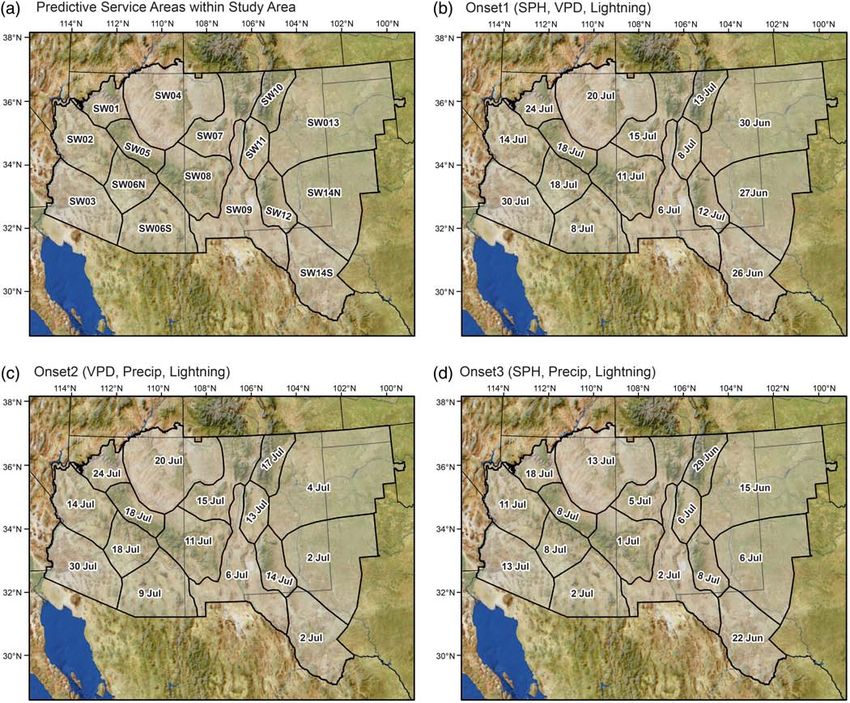
Impact of the North American monsoon on wildfire activity in the southwest United States
1540                                                                                                                                     NAUSLAR ET AL.

FIGURE 1    (a) Map of study area and the Southwest Area outlined and shaded. (b) Study area showing the Southwest Area Predictive Service Areas (PSAs).
SW01 is also known as PSA 1 [Colour figure can be viewed at wileyonlinelibrary.com]

1984; Douglas et al., 1993; Higgins et al., 1999; Hawkins                     the return to a cold season circulation with an equatorwards
et al., 2002; Lo and Clark, 2002). The variability of NAM in                  migration of the polar jet stream. This transition is noted by
the southwestern United States is large, sometimes larger                     a return of the westerlies from a diurnally driven, warm-
than the mean warm season rainfall, and is modulated by                       season circulation of easterly and southerly flow over the
intra-seasonal transient features including tropical easterly                 NAM region (Higgins et al., 1997; Barlow et al., 1998; Vera
waves, tropical storms/cyclones, and transient upper-                         et al., 2006; Cerezo-Mota et al., 2011; Means, 2012).
tropospheric troughs (Higgins et al., 1998; Adams and                             There are several definitions for the NAM onset, but it is
Stensrud, 2007; Abatzoglou and Brown, 2009; Hendon                            generally characterized by an increase of atmospheric
et al., 2011; Favors and Abatzoglou, 2012; Means, 2012;                       humidity and precipitation associated with the establishment
Newman and Johnson, 2012; Mejia et al., 2015; Seastrand                       of the subtropical ridge over western Mexico and the South-
et al., 2015; Pascale and Bordoni, 2016).                                     west (Adams and Comrie, 1997; Higgins et al., 1997; Ellis
     Higgins et al. (1997) describe the NAM in three phases:                  et al., 2004; Grantz et al., 2007). However, a universally
development, mature, and decay. The development of the                        accepted NAM onset definition does not exist for the South-
NAM (May–June) is characterized by a transition of gener-                     west. NAM onset definitions include a dewpoint temperature
ally westerly flow associated with a boreal winter circulation                of 54  F at the Tucson airport (National Weather Service
shifting to a southerly and easterly flow, and moves north-                   Weather Forecast Office Tucson, 2015), a precipitation
wards as the subtropical ridge develops over Mexico and the                   threshold +0.5 mm/day for three consecutive days (Higgins
Southwest (Bryson and Lowry, 1955; Adams and Comrie,                          et al., 1997), or a Gulf of California sea surface temperature
1997; Grantz et al., 2007). The shift in winds is in response                 of 26  C (Mitchell et al., 2002).
to surface heating over the continent, especially over the ele-                   Limited research has examined the relationship between
vated terrain in the NAM region (Figure 1a). As the land–                     the NAM and wildfire occurrence in the western United
ocean temperature gradient increases, air flows towards the                   States (Mohrle, 2003; Brandt, 2006; Evett et al., 2008). In
continent increasing convergence and enhancing the                            the Southwest, wildfire occurrence increases steadily
mountain–valley circulation over the Sierra Madre Occiden-                    through April, but the rate accelerates in May and June
tal (Douglas et al., 1993; Vera et al., 2006; Gochis and Hig-                 before decreasing in late July through September (Brandt,
gins, 2007; Grantz et al., 2007). The pronounced diurnal                      2006). The peak Southwest wildfire season occurs in June
cycle of rainfall associated with the NAM initially develops                  and early July due to decreasing fuel moisture, increasing
in southern Mexico before extending north to the Sierra                       temperatures, and enhanced ignition potential coinciding
Madre Occidental and the Southwest (June–July) (Douglas                       with drier thunderstorms before the NAM onset (Watson
et al., 1993; Adams and Comrie, 1997; Higgins et al.,                         et al., 1994; Westerling et al., 2003). The NAM increases
1997). The heaviest precipitation occurs in July and August                   cloud-to-ground lightning, which increases “natural” wild-
during the mature stage then wanes in September (Carleton                     fire ignitions, but with the corresponding increase in atmo-
et al., 1990; Douglas et al., 1993; Higgins et al., 1997). The                spheric and fuel moisture, wildfires often remain small as
NAM decay phase is more gradual than onset and represents                     the NAM matures (Evett et al., 2008; Dowdy and Mills,
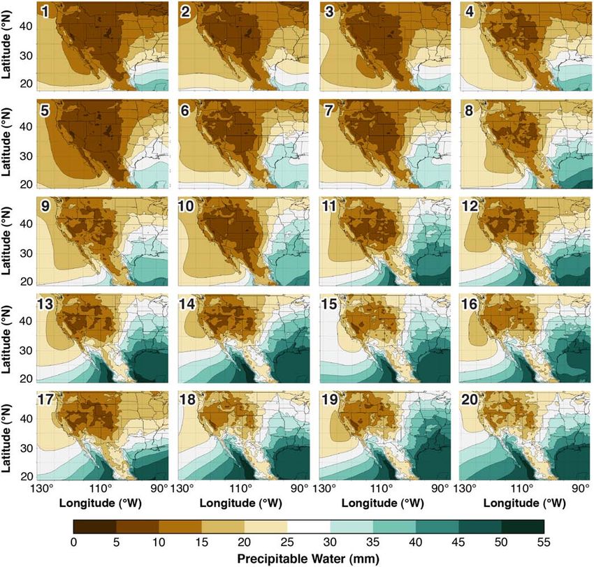
Impact of the North American monsoon on wildfire activity in the southwest United States
NAUSLAR ET AL.                                                                                                                         1541

2012). The increase of cloud-to-ground lightning is related       2 | DATA
to 57% of natural wildfires that occur after NAM onset
(Mohrle, 2003). Moreover, Mohrle (2003) notes 55% of              Data were collected for the SWA spanning April through
large wildfires (40 ha) and nearly 50% of area burned from        September from 1995 to 2013 unless otherwise specified.
large wildfires occur after onset demonstrating the delayed       Southwest Predictive Services defined the PSAs as having
effects of NAM precipitation on fuel moisture recovery.           similar historical wildfire occurrences, fuel types, fuel indices,
However, wildfire occurrence abruptly decreases approxi-          and climates (i.e., temperature and precipitation characteristics)
mately midway through the climatological peak of lightning        (Figure 1b). They also determined large fire thresholds based
and precipitation (late July to early August) in Arizona and      on historical fire records and suppression needs (Table 1).
New Mexico as fuel moisture rebounds (Hall, 2007).                    We used daily, 4-km surface gridded data of precipita-
    While a direct relationship exists between weather and        tion, minimum and maximum relative humidity (RH,
wildfires, this relationship can be complex and nonlinear.        RHmin, RHmax), specific humidity (q), minimum and maxi-
Synoptic composites are often used to examine the relation-       mum temperature (Tmin, Tmax), and wind speed from the
ships between the dominant atmospheric circulation systems        University of Idaho METDATA (Abatzoglou, 2013).
and ecological factors (Hewitson and Crane, 2002). Self-          Vapour pressure deficit (VPD) was defined as the difference
                                                                  between saturated vapour pressure and ambient vapour pres-
organizing maps (SOMs) are utilized to identify atmospheric
                                                                  sure. Saturated vapour pressure (es; in mb) was calculated
circulation patterns associated with different phenomena due
                                                                  using Teten’s (1930) formula as follows:
to their propensity for objectively characterizing the complex
                                                                                                            
distribution of synoptic states (Kohonen, 2001; Cavazos                                                     ð7:5T Þ
                                                                                                          ð237:3+ T Þ
et al., 2002; Hewitson and Crane, 2002; Reusch et al., 2005;                            es ¼ 6:11  10                  ,
Crimmins, 2006; Reusch et al., 2007; Reusch, 2011; Swales                                        
                                                                  where T is temperature in C. Vapour pressure deficit (VPD;
et al., 2016). For example, Cavazos et al. (2002) showed          in mb) was then calculated as
that the NAM in southeast Arizona was dominated by three
wet modes, while Crimmins (2006) identified different                                    VPD ¼ es  RH=100,
atmospheric patterns associated with extreme fire weather         where RH is relative humidity in percent. A single daily
conditions in the Southwest.                                      PSA value for each variable was calculated by averaging all
    Days with numerous wildfire ignitions and multiday            grid point values of each variable within a PSA.
wildfire events are of particular importance to fire meteorol-        Daily 700 and 500 hPa winds, geopotential heights, and
ogists and managers due to the strain these events place on       q and daily precipitable water (PW) were obtained from the
local, regional, and national suppression resources. Specifi-     National Center for Environmental Prediction (NCEP) North
cally, the Southwest Geographic Area Coordination Center,         American Regional Reanalysis (NARR; Mesinger et al.,
which oversees the coordination of firefighting resources in      2006) and downloaded from the Earth System Research
the Southwest Area (SWA) (Arizona, New Mexico, west               Laboratory Physical Sciences Division (https://www.esrl.
Texas, and Oklahoma Panhandle) (Figure 1b) would bear
the brunt of these impacts from these significant wildfire epi-   TABLE 1    Large wildfire threshold for each PSA in the SWA as
sodes or “busy” days as fire management describes them.           determined by southwest PS
Identifying atmospheric patterns pertinent to significant          PSA                                     Large wildfire threshold (acres)
wildfire episodes in the SWA could provide improved pre-           SW01                                    100
diction of significant wildfire episodes. This would facilitate    SW02                                    300
more efficient allocation of firefighting resources during         SW03                                    300
busy days.                                                         SW04                                    100
    In this analysis, we examine various definitions and           SW05                                    50
thresholds for determining the NAM onset and significant           SW06S                                   100
wildfire episodes (busy days) within the SWA and its indi-         SW06N                                   500
vidual Predictive Services Areas (PSAs) (Figure 1b). We            SW07                                    100
suggest that SOMs can help examine the intricate nonlinear         SW08                                    300
relationships between the NAM and critical fire weather pat-       SW09                                    300

terns leading to significant wildfire episodes. We implement       SW10                                    100

SOMs to identify synoptic patterns that correspond to the          SW11                                    100

NAM onset and significant wildfire episodes including those        SW12                                    100
                                                                   SW13                                    2000
atmospheric patterns that are prevalent before, during, and
                                                                   SW14                                    200
after these events. SOMs help infer the associated physical
                                                                   SW14N                                   2000
climate processes between the NAM and wildfire activity.
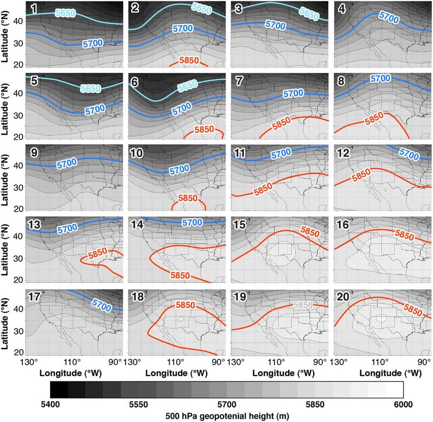
Impact of the North American monsoon on wildfire activity in the southwest United States
1542                                                                                                                            NAUSLAR ET AL.

noaa.gov/psd/data/gridded/data.narr.html). Despite some            realistic results based on operational fire weather forecaster
known limitations of NARR (Dominguez et al., 2008;                 experience. For each PSA, the 10th percentile, 90th percen-
Becker et al., 2009; Cerezo-Mota et al., 2011), numerous           tile, median, inter-quartile range, and ±1 median absolute
studies have shown NARR representative when examining              deviation onset dates were calculated.
synoptic circulation and moisture across the study region
(e.g., Dominguez et al., 2008; Dominguez and Kumar,
2008; Turrent and Cavazos, 2012; Doubler et al., 2015; Rad-        3.2 | Significant wildfire episodes
hakrishna et al., 2015). We used a subset of daily NARR
                                                                   The FPA wildfire occurrence data were organized by PSA
data that spanned from 85 W to 131 W longitude and 18 N
                                                                   and separated into categories based on size and type. If a day
to 49.5 N latitude.
    Wildfire data were obtained from the Fire Program Anal-        exceeded the 95th (99th) percentile for number of wildfires
ysis (FPA) quality controlled wildfire database (Short,            and large wildfires or at least two (three) large wildfires
2015), which has the size, location, discovery date, ignition      occurred for a PSA, it was considered a “busy day” and
cause (i.e., type) among other information for each wildfire.      exceeded the Busy95_PSA (Busy99_PSA) threshold. If a
Wildfires were categorized by type (all, lightning, human)         day exceeded the 95th (99th) percentile for number of large
and size (all, large) for each PSA, and large wildfire criteria    wildfires for the SWA, it was considered a “busy day” and
were established from large wildfire thresholds determined         exceeded the Busy95_SW (Busy99_SW) threshold. Periods
by Southwest Predictive Services (Table 1). The Program            of 2, 3, 7, and 10 days that exceeded the 95th and 99th per-
for Climate, Ecosystem, and Fire Applications at the Desert        centiles for large wildfires for the SWA over those respec-
Research Institute provided proprietary National Lightning         tive time periods were identified as “busy events.” These
Detection Network® CG lightning data.                              thresholds and periods represent a level of fire activity that
                                                                   can begin to stress local and regional wildfire suppression
                                                                   resources. The busy days and events were examined primar-
3 | METHODS                                                        ily to determine (a) when these episodes occurred most fre-
                                                                   quently and (b) to examine synoptic patterns during
3.1 | The North American monsoon onset                             significant wildfire episodes (i.e., busy days or events).
The predictors selected for determining the NAM onset were
the daily averaged PSA values of q, VPD, cloud-to-ground
lightning strikes (LS), and precipitation. These variables
were chosen because each represents atmospheric moisture
or thunderstorm coverage, which are hallmarks of the NAM
onset. To eliminate potential “pre-monsoonal” moisture
surges, time periods of 3–10 days and variable thresholds
that exceeded the 22 year, April through September PSA
mean or median values for q and precipitation were consid-
ered. Periods where VPD values were less than their 22-year
mean or median were also considered. A threshold of
100 LS was chosen due to the Storm Prediction Center using
it as its forecast lightning density threshold and after examin-
ing various thresholds between 25 and 200 LS. The primary
technique for identifying NAM onset used six consecutive
days of greater (less) than or equal to the 22-year median
PSA value of q (VPD) and six consecutive days of at least
100 lightning strikes occurring concurrently (onset 1). Other
combinations of variables were evaluated that substituted
precipitation for q (onset 2) or VPD (onset 3). The NAM
onset date for each PSA was determined by taking the first
instance that met the onset 1, onset 2, or onset 3 requirements
after May 31. We constrained the onset after May 31 to min-        FIGURE 2      Self-organizing map node distances for the 4 × 5 grid 4,000
imize the influences of spring storms and also pre-monsoon         iteration solution. The blue hexagons represent the nodes and the red lines
                                                                   connect neighbouring nodes. The colours in the regions containing the red
moisture surges. While noting the subjectivity of these
                                                                   lines indicate the distances between nodes with the darker colours
methods, they do represent the fundamental weather and cli-        representing larger distances and lighter colours representing smaller
mate shift the NAM exerts on the SWA and produces                  distances [Colour figure can be viewed at wileyonlinelibrary.com]
Impact of the North American monsoon on wildfire activity in the southwest United States
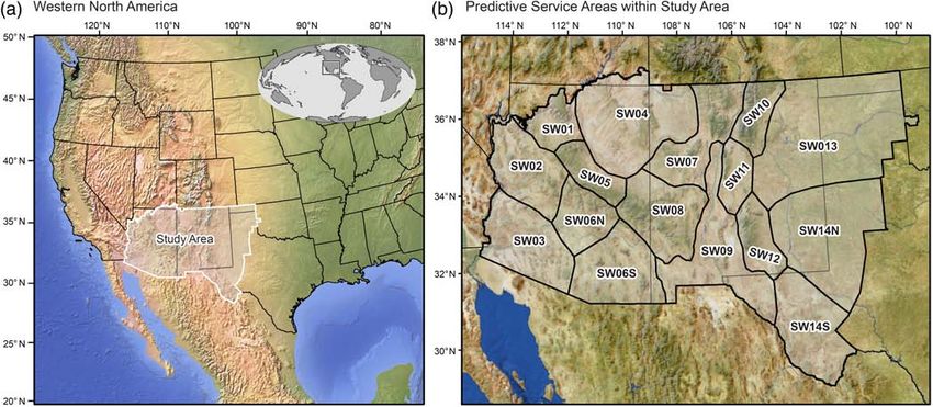
NAUSLAR ET AL.                                                                                                                                 1543

3.3 | Self-organizing maps                                                  and continues until the node locations and densities con-
As noted in the introduction, SOMs are a nonparametric                      verge on a solution and become stable (i.e., stop changing)
analysis technique based on neural networks that extract                    (Hewitson and Crane, 2002). The iterative SOMs process
generalized patterns from gridded data defined over a region                clusters nodes in regions where there is more information
(Kohonen, 2001). SOMs can process multivariate, multidi-                    while spanning the distribution of data and placing similar
mensional input on a user-defined grid (e.g., 4 × 3;                        (dissimilar) nodes closer to (farther from) each other
12 nodes) by creating a spatially organized set of generalized              (Hewitson and Crane, 2002). The SOMs divide a continuum
patterns of variability from the input data (Reusch et al.,                 of atmospheric patterns into a small number of categories,
2005; 2007; Reusch, 2011). SOMs capture the most notable                    which are spatially organized by similarity with similar pat-
atmospheric circulation patterns. Because the analysis is per-              terns closer to each other and dissimilar patterns further
formed over daily time increments, such patterns include                    away from each other on the user-defined grid (Hewitson
those modes related to synoptic scale variations (Cavazos                   and Crane, 2002; Reusch, 2011). By identifying atmospheric
et al., 2002; Reusch et al., 2007). This process is iterative               circulation patterns, SOMs allows a frequency analysis of

FIGURE 3    Twenty SOM reference nodes (MTs) in the 4 × 5 SOM grid arrangement for 500 hPa geopotential heights (m), contoured and colour shaded
every 30 m [Colour figure can be viewed at wileyonlinelibrary.com]
Impact of the North American monsoon on wildfire activity in the southwest United States
1544                                                                                                                                NAUSLAR ET AL.

each pattern, preferred transitions, and the ability to associate           SOMs and the implementation of SOMs for meteorologi-
patterns with events (Cavazos et al., 2002; Reusch et al.,                  cal and climatological applications.
2005; Reusch et al., 2007).                                                      SOMs were implemented using various packages from
    Although we did initially examine results using prin-                   the Neural Network Toolbox in MATLAB© (Mathworks,
cipal component analysis and k-means clustering, the                        2017). The input data consisted of standardized daily values
SOMs methodology was ultimately chosen because it has                       of NARR 500-hPa geopotential heights, 700-hPa geopoten-
been shown to be more robust, accurate, and able to pro-                    tial heights, and PW on a 175 × 120 grid (85 –131 W; 18 –
vide better discriminating power of variability patterns in                 49.5 N) for 183 days (April 1 to September 30) over
large, nonlinear data sets (Reusch et al., 2005; 2007).                     22 years (1992–2013). SOMs require standardized data
Furthermore, SOMs allows more discrimination among                          when using multiple variables with varying scales (Reusch
subtle variations of similar atmospheric patterns                           et al., 2007; Reusch, 2011). All input data were included
(Hewitson and Crane, 2002). Kohonen (2001), Hewitson                        together for training because the primary goal of SOMs is to
and Crane (2002), (Reusch et al., 2005; 2007), and                          use generalized patterns determined from the input data as
Reusch (2011) provide further detailed explanations of                      recommended by Reusch (2011). Asymmetrical grid

FIGURE 4     Twenty SOM reference nodes (MTs) in the 4 × 5 SOM grid arrangement for precipitable water (mm), contoured and colour shaded every 5 mm
[Colour figure can be viewed at wileyonlinelibrary.com]
Impact of the North American monsoon on wildfire activity in the southwest United States
NAUSLAR ET AL.                                                                                                                                   1545

configurations of nodes are recommended (Kohonen, 2001;                       resolved expected atmospheric patterns for the study area
Reusch et al., 2007) thus node grid arrays of 4 × 3 (rows by                  during the examined period (e.g., Hewitson and Crane,
columns), 5 × 3, and 4 × 5 were examined at 500, 1,000,                       2002). However, the 4 × 5 grid resolved two patterns corre-
2,000, and 4,000 iterations or until there was little variation               sponding to busy and NAM onset days that were not well
of node densities and locations (i.e., stable). Sammon maps                   represented by the 4 × 3 and 5 × 3 grids. The 20 node con-
of multidimensional data on the different SOMs grids (not                     figuration versus the 12 or 15 node configuration helped dis-
shown) and matching the input data to the final reference                     criminate relatively subtle variations in the atmospheric
nodes of these grids displayed how dissimilar the nodes were                  circulation patterns especially at the intersection of troughs
and the distances among those nodes (Figure 2) (Sammon,                       and ridges, which helped identify these two additional
1969; Reusch et al., 2007). Plots of neighbour node dis-                      important MTs.
tances and examining the dates associated with each node                          A stable solution was reached after 2,000 iterations on
were also helpful in examining the SOMs solutions                             the 4 × 5 SOMs grid, but the 4,000 iteration version was uti-
(Figure 2). Each node was assigned a number (1–20) via                        lized due to the slightly better coverage and shape from the
SOMs, which helped facilitate analysis of the solutions.                      Sammon map depiction (not shown). Figures 3 and 4 display
After a stable solution was reached, each day was classified                  the resulting 20 composite MTs from the SOMs analysis.
                                                                              Map type 1 (MT 1, e.g., Figure 3, MT 1) for 500-hPa geopo-
with a node as a best match, which was composited into a
                                                                              tential heights directly corresponds to MT 1 for both
map type (MT) for a particular meteorological variable
                                                                              700-hPa geopotential heights (not shown; similar to 500 hPa
(Reusch, 2011). After each day was classified, a frequency
                                                                              patterns) and PW (e.g.., Figure 4, MT 1) because all three
analysis was applied to all days, busy days/events, and onset
                                                                              variables were included in the same SOMs analysis. Anom-
days where applicable to determine if individual MTs or MT
                                                                              aly MTs were created, but as they were very similar in
transitions were more associated with certain types of
                                                                              appearance, they are not shown here.
events.
                                                                                  Each MT represents a node from the SOMs solution
                                                                              using the 4 × 5 grid with 4,000 iterations. Figure 2 dis-
4 | RE SUL TS                                                                 plays the distances (e.g., magnitude of dissimilarity) among
                                                                              adjacent nodes, and each one of those nodes corresponds
                                                                              directly to the MTs in Figures 3 and 4. For example, the
4.1 | Atmospheric map types and NAM “life cycle”
                                                                              node at the very top, left of Figure 2, directly corresponds
The Sammon maps and neighbour node distances and densi-                       to MT 1. The number assigned to each node increases left
ties for the three examined node grid configurations were all                 to right across the columns and top to bottom across the
generally acceptable. Each grid configuration satisfied                       rows. This layout helps compare the nodes/MTs mathemati-
recommended SOMs mathematical requirements and                                cally and meteorologically.

TABLE 2   Map type (MT) occurrence by month summed for the period of 1995–2013 and associated median lightning strike (LS) total decile

                  April              May              June             July              August             September               Median LS decile
 MT 1             134                1                0                0                 0                  0                       1
 MT 2             104                18               0                0                 0                  0                       1
 MT 3             98                 43               0                0                 0                  0                       1
 MT 4             54                 64               2                0                 0                  0                       3
 MT 5             103                36               0                0                 0                  0                       1
 MT 6             107                29               0                0                 0                  0                       1
 MT 7             35                 137              15               0                 0                  3                       2
 MT 8             1                  93               79               0                 0                  6                       4
 MT 9             16                 124              33               0                 0                  13                      4
 MT 10            8                  106              51               0                 0                  9                       2
 MT 11            0                  7                164              19                8                  30                      4
 MT 12            0                  4                76               17                27                 83                      5
 MT 13            0                  4                88               12                7                  126                     4
 MT 14            0                  0                29               55                70                 76                      5
 MT 15            0                  0                34               83                86                 36                      6
 MT 16            0                  0                34               146               97                 8                       8
 MT 17            0                  16               29               1                 0                  160                     3
 MT 18            0                  0                14               52                110                78                      6
 MT 19            0                  0                8                170               145                19                      7
1546                                                                                                                                      NAUSLAR ET AL.

    Ascending numbered MTs follow a general progression                       axis that extends from the south and east over Mexico and
of increasing geopotential heights and PW (Figures 3 and 4,                   the Gulf of Mexico (Table 2 and Figure 3, MTs 7–10).
MTs 1–20). Tighter geopotential height gradients, deeper                      Drier conditions remain over most of the SWA, but PW
troughs with lower heights, and drier conditions are illus-                   increases on the western and eastern coasts of Mexico
trated at lowered numbered MTs (Figures 3 and 4, MTs                          (Figure 4, MTs 7–10). Geopotential heights continue to
1–10) over the SWA and are most frequent in April and                         increase and the variation between troughs and ridges over
May (Table 2). Ascending numbered MTs generally occur                         the SWA maximizes during June (Table 2 and Figure 3,
in roughly chronological order through August. This trend                     MTs 8, 11–13). In June, the subtropical ridge axis is
parallels the amplification of subtropical ridge and increased                centred over western and northwestern Mexico and PW
moisture over northwestern Mexico and the SWA, which is                       increases in extent and magnitude across Mexico, the
indicative of the NAM (Figures 3 and 4 and Table 2)                           Plains, and the SWA (Figures 3 and 4, MTs 11–13;
(e.g., Douglas et al., 1993; Adams and Comrie, 1997; Stens-                   e.g., PSAs 13 , 14 N, 14 S). The increase in lower-
rud et al., 1997). As the NAM decays in September, lower                      tropospheric moisture from the Gulf of Mexico is due in
numbered MTs become more frequent indicating a decrease                       large part to the Low-Level Jet (Stensrud, 1996; Higgins
in geopotential heights and drier conditions (Figures 3 and 4,                et al., 1997; Stensrud et al., 1997). During July, the transi-
MTs 12–13).                                                                   tion to a ridge-dominated atmospheric pattern is complete
    April is characterized by deeper troughs and dry condi-                   with the establishment of the Four Corners High (i.e., MT
tions prevailing across the SWA (Table 2 and Figures 3                        20). This pattern continues through August with easterlies
and 4, MTs 1–2, 5–6). The most prevalent MTs in May                           shifting northwards bringing ample moisture across much
depict various longitudinal extents of the subtropical ridge                  of Mexico and into the SWA (Table 2 and Figures 3 and

FIGURE 5   PSA median onset date for the three different onset metrics from 1995 to 2013 [Colour figure can be viewed at wileyonlinelibrary.com]
NAUSLAR ET AL.                                                                                                                                                                                                                                                                                                                                                                                                                                           1547

                                                                                                                                                                                                                                                                                                                                                                                               4, MTs 15–16, 18–20). In September, the subtropical ridge

                                                                                                                                                                                                                         SW14N

                                                                                                                                                                                                                                                                    Aug 20

                                                                                                                                                                                                                                                                                                                              Aug 10

                                                                                                                                                                                                                                                                                                                                                                                      Aug 6
                                                                                                                                                                                                                                 Jul 27

                                                                                                                                                                                                                                                                             Jun 5

                                                                                                                                                                                                                                                                                                                                       Jun 2
                                                                                                                                                                                                                                                                                                                                                                                               becomes less amplified with MTs demonstrating weaker

                                                                                                                                                                                                                                                                                      Jul 2

                                                                                                                                                                                                                                                                                                                                                Jul 6
                                                                                                                                                                                                                                                        52
                                                                                                                                                                                                                                                              19

                                                                                                                                                                                                                                                                                                                  53
                                                                                                                                                                                                                                                                                                                        26

                                                                                                                                                                                                                                                                                                                                                                                20
                                                                                                                                                                                                                                                                                                                                                                          37
               Median, inter-quartile range (IQR; number of days), median absolute deviation (MAD; number of days), 10th percentile onset date, and 90th percentile onset day-of-year (DOY) by PSA for the three onset

                                                                                                                                                                                                                                                                                                                                                                                               ridges and troughs over the Southwest (Figure 3, MTs
                                                                                                                                                                                                                                                                                                                                                                                               12–13, 17).
                                                                                                                                                                                                                         SW14S

                                                                                                                                                                                                                                                                                                                              Aug 14
                                                                                                                                                                                                                                 Jun 26

                                                                                                                                                                                                                                                                             Jun 14

                                                                                                                                                                                                                                                                                                                                       Jun 14
                                                                                                                                                                                                                                                                                                                                                Jun 22
                                                                                                                                                                                                                                                                    Aug 4

                                                                                                                                                                                                                                                                                                                                                                                      Aug 1
                                                                                                                                                                                                                                                                                                                                                                                                   The four most frequent MTs (Figure 3, e.g., MTs

                                                                                                                                                                                                                                                                                      Jul 2
                                                                                                                                                                                                                                                        34
                                                                                                                                                                                                                                                              11

                                                                                                                                                                                                                                                                                                                  39
                                                                                                                                                                                                                                                                                                                        16

                                                                                                                                                                                                                                                                                                                                                                                15
                                                                                                                                                                                                                                                                                                                                                                          40
                                                                                                                                                                                                                                                                                                                                                                                               16, 18–20) show the SWA under the influence of the sub-
                                                                                                                                                                                                                                                                                                                                                                                               tropical ridge, which is expected during the NAM (Adams
                                                                                                                                                                                                                                 Jun 30

                                                                                                                                                                                                                                                                                                                                                Jun 15
                                                                                                                                                                                                                         SW13

                                                                                                                                                                                                                                                                                                                              Aug 9
                                                                                                                                                                                                                                                                    Jul 23

                                                                                                                                                                                                                                                                                                                                                                                      Jul 11
                                                                                                                                                                                                                                                                             Jun 4

                                                                                                                                                                                                                                                                                                                                       Jun 5
                                                                                                                                                                                                                                                                                                                                                                                               and Comrie, 1997; Higgins et al., 1997). PW increases in
                                                                                                                                                                                                                                                                                      Jul 4
                                                                                                                                                                                                                                                        21
                                                                                                                                                                                                                                                              11

                                                                                                                                                                                                                                                                                                                  34
                                                                                                                                                                                                                                                                                                                        19

                                                                                                                                                                                                                                                                                                                                                                          22
                                                                                                                                                                                                                                                                                                                                                                                8
                                                                                                                                                                                                                                                                                                                                                                                               magnitude and northwards extent during ridging confirming
                                                                                                                                                                                                                                                                                                                                                                                               prior research (Figures 3 and 4, e.g., MTs 15–16, 18–20)

                                                                                                                                                                                                                                                                                                                                                                                      Aug 10
                                                                                                                                                                                                                                                                                                                              Aug 12
                                                                                                                                                                                                                                                                             Jun 18

                                                                                                                                                                                                                                                                                                                                       Jun 14
                                                                                                                                                                                                                         SW12

                                                                                                                                                                                                                                                                    Aug 4
                                                                                                                                                                                                                                 Jul 12

                                                                                                                                                                                                                                                                                      Jul 14

                                                                                                                                                                                                                                                                                                                                                                                               (Carleton et al., 1990; Higgins et al., 1999; Cerezo-Mota

                                                                                                                                                                                                                                                                                                                                                Jul 8
                                                                                                                                                                                                                                                        26
                                                                                                                                                                                                                                                              14

                                                                                                                                                                                                                                                                                                                  36
                                                                                                                                                                                                                                                                                                                        18

                                                                                                                                                                                                                                                                                                                                                                                13
                                                                                                                                                                                                                                                                                                                                                                          32
                                                                                                                                                                                                                                                                                                                                                                                               et al., 2011). Lightning strikes also increase during these
                                                                                                                                                                                                                                                                                                                                                                                               ridging patterns. MTs 16, 20 have the highest median light-
                                                                                                                                                                                                                                                                             Jun 11

                                                                                                                                                                                                                                                                                                                                       Jun 14
                                                                                                                                                                                                                         SW11

                                                                                                                                                                                                                                                                    Aug 1

                                                                                                                                                                                                                                                                                                                              Aug 3
                                                                                                                                                                                                                                                                                      Jul 13

                                                                                                                                                                                                                                                                                                                                                                                      Jul 18
                                                                                                                                                                                                                                 Jul 8

                                                                                                                                                                                                                                                                                                                                                Jul 6
                                                                                                                                                                                                                                                                                                                                                                                               ning decile (Table 2) and MTs 16, 19–20 are most associated
                                                                                                                                                                                                                                                        25
                                                                                                                                                                                                                                                              13

                                                                                                                                                                                                                                                                                                                  20
                                                                                                                                                                                                                                                                                                                        10

                                                                                                                                                                                                                                                                                                                                                                          18
                                                                                                                                                                                                                                                                                                                                                                                9
                                                                                                                                                                                                                                                                                                                                                                                               with days exceeding the 70th percentile of LS across
                                                                                                                                                                                                                                                                                                                                                                                               the SWA.
                                                                                                                                                                                                                                                                             Jun 16

                                                                                                                                                                                                                                                                                                                                       Jun 25
                                                                                                                                                                                                                                                                                                                                                Jun 29
                                                                                                                                                                                                                         SW10

                                                                                                                                                                                                                                                                                                                              Aug 3
                                                                                                                                                                                                                                 Jul 13

                                                                                                                                                                                                                                                                    Jul 28

                                                                                                                                                                                                                                                                                      Jul 17

                                                                                                                                                                                                                                                                                                                                                                                      Jul 19
                                                                                                                                                                                                                                                        29
                                                                                                                                                                                                                                                              13

                                                                                                                                                                                                                                                                                                                  28
                                                                                                                                                                                                                                                                                                                        14

                                                                                                                                                                                                                                                                                                                                                                          21
                                                                                                                                                                                                                                                                                                                                                                                6

                                                                                                                                                                                                                                                                                                                                                                                               4.2 | Quantifying NAM onset by Predictive
                                                                                                                                                                                                                                                                             Jun 20

                                                                                                                                                                                                                                                                                                                                       Jun 12
                                                                                                                                                                                                                         SW09

                                                                                                                                                                                                                                                                                                                                                                                               Services Area
                                                                                                                                                                                                                                                                    Jul 30

                                                                                                                                                                                                                                                                                                                              Jul 30

                                                                                                                                                                                                                                                                                                                                                                                      Jul 24
                                                                                                                                                                                                                                 Jul 6

                                                                                                                                                                                                                                                                                      Jul 6

                                                                                                                                                                                                                                                                                                                                                Jul 2
                                                                                                                                                                                                                                                        17

                                                                                                                                                                                                                                                                                                                  17

                                                                                                                                                                                                                                                                                                                                                                          11
                                                                                                                                                                                                                                                              7

                                                                                                                                                                                                                                                                                                                        7

                                                                                                                                                                                                                                                                                                                                                                                7

                                                                                                                                                                                                                                                                                                                                                                                               Figure 5 and Table 3 provide the median onset date, inter-
                                                                                                                                                                                                                                                                                                                                                                                               quartile range, median absolute deviation, 10th percentile
                                                                                                                                                                                                                                                                             Jun 28

                                                                                                                                                                                                                                                                                                                                       Jun 28
                                                                                                                                                                                                                         SW08
                                                                                                                                                                                                                                 Jul 11

                                                                                                                                                                                                                                                                    Jul 24

                                                                                                                                                                                                                                                                                      Jul 11

                                                                                                                                                                                                                                                                                                                              Jul 25

                                                                                                                                                                                                                                                                                                                                                                                      Jul 15
                                                                                                                                                                                                                                                                                                                                                Jul 1
   metrics using specific humidity (q), vapour pressure deficit (VPD), precipitation (precip), and lightning strikes (LS) from 1995 to 2013

                                                                                                                                                                                                                                                                                                                                                                                               onset date, and 90th percentile onset date by PSA for the
                                                                                                                                                                                                                                                        15

                                                                                                                                                                                                                                                                                                                  16

                                                                                                                                                                                                                                                                                                                                                                          14
                                                                                                                                                                                                                                                              8

                                                                                                                                                                                                                                                                                                                        8

                                                                                                                                                                                                                                                                                                                                                                                8

                                                                                                                                                                                                                                                                                                                                                                                               three onset metrics implemented. Onset1 (q, VPD, and light-
                                                                                                                                                                                                                                                                                                                                                                                               ning) and onset 2 (VPD, precipitation, and lightning) gener-
                                                                                                                                                                                                                         SW07

                                                                                                                                                                                                                                                                    Aug 3

                                                                                                                                                                                                                                                                                                                              Aug 9
                                                                                                                                                                                                                                 Jul 15

                                                                                                                                                                                                                                                                                      Jul 15

                                                                                                                                                                                                                                                                                                                                                                                      Jul 14
                                                                                                                                                                                                                                                                             Jul 1

                                                                                                                                                                                                                                                                                                                                       Jul 1
                                                                                                                                                                                                                                                                                                                                                Jul 5

                                                                                                                                                                                                                                                                                                                                                                                               ally produce the same results with some variation across
                                                                                                                                                                                                                                                        21
                                                                                                                                                                                                                                                              11

                                                                                                                                                                                                                                                                                                                  25
                                                                                                                                                                                                                                                                                                                        12

                                                                                                                                                                                                                                                                                                                                                                          16
                                                                                                                                                                                                                                                                                                                                                                                8

                                                                                                                                                                                                                                                                                                                                                                                               eastern New Mexico and west Texas (Figure 5). Onset 3 (q,
                                                                                                                                                                                                                         SW06N

                                                                                                                                                                                                                                                                                                                                                                                               precipitation, and lightning) uniformly shows earlier median
                                                                                                                                                                                                                                                                             Jun 30

                                                                                                                                                                                                                                                                                                                                       Jun 30
                                                                                                                                                                                                                                                                    Aug 3

                                                                                                                                                                                                                                                                                                                              Aug 3
                                                                                                                                                                                                                                 Jul 18

                                                                                                                                                                                                                                                                                      Jul 18

                                                                                                                                                                                                                                                                                                                                                                                      Jul 25
                                                                                                                                                                                                                                                                                                                                                Jul 8

                                                                                                                                                                                                                                                                                                                                                                                               onset dates for every PSA except PSA SW14N (Figure 5),
                                                                                                                                                                                                                                                        19
                                                                                                                                                                                                                                                              11

                                                                                                                                                                                                                                                                                                                  17

                                                                                                                                                                                                                                                                                                                                                                          15
                                                                                                                                                                                                                                                                                                                        5

                                                                                                                                                                                                                                                                                                                                                                                8

                                                                                                                                                                                                                                                                                                                                                                                               and onset 3 is less temporally variable than onset 1 and onset
                                                                                                                                                                                                                                                                                                                                                                                               2 (Table 3). Most onset dates for all the metrics occur in
                                                                                                                                                                                                                         SW06S

                                                                                                                                                                                                                                                                             Jun 29

                                                                                                                                                                                                                                                                                                                                       Jun 29
                                                                                                                                                                                                                                                                    Jul 20

                                                                                                                                                                                                                                                                                                                              Jul 20

                                                                                                                                                                                                                                                                                                                                                                                      Jul 15
                                                                                                                                                                                                                                 Jul 8

                                                                                                                                                                                                                                                                                      Jul 9

                                                                                                                                                                                                                                                                                                                                                Jul 2

                                                                                                                                                                                                                                                                                                                                                                                               early to mid-July with a few instances of late June onset
                                                                                                                                                                                                                                                        10

                                                                                                                                                                                                                                                                                                                  10

                                                                                                                                                                                                                                                                                                                                                                          10
                                                                                                                                                                                                                                                              6

                                                                                                                                                                                                                                                                                                                        6

                                                                                                                                                                                                                                                                                                                                                                                7

                                                                                                                                                                                                                                                                                                                                                                                               dates in some of the eastern New Mexico and west Texas
                                                                                                                                                                                                                                                                                                                                                                                               PSAs (Figure 5). Depending on the PSA and metrics, the
                                                                                                                                                                                                                         SW05

                                                                                                                                                                                                                                                                    Aug 7

                                                                                                                                                                                                                                                                                                                              Aug 7
                                                                                                                                                                                                                                 Jul 18

                                                                                                                                                                                                                                                                                      Jul 18

                                                                                                                                                                                                                                                                                                                                                                                      Jul 17
                                                                                                                                                                                                                                                                             Jul 3

                                                                                                                                                                                                                                                                                                                                       Jul 3
                                                                                                                                                                                                                                                                                                                                                Jul 8

                                                                                                                                                                                                                                                                                                                                                                                               inter-quartile range can range from 10 to 53 days although
                                                                                                                                                                                                                                                        19
                                                                                                                                                                                                                                                              10

                                                                                                                                                                                                                                                                                                                  19
                                                                                                                                                                                                                                                                                                                        10

                                                                                                                                                                                                                                                                                                                                                                          15
                                                                                                                                                                                                                                                                                                                                                                                7

                                                                                                                                                                                                                                                                                                                                                                                               most inter-quartile ranges total less than 35 days (Table 3).
                                                                                                                                                                                                                                                                    Aug 12

                                                                                                                                                                                                                                                                                                                              Aug 12

                                                                                                                                                                                                                                                                                                                                                                                               The median absolute deviations for onset are generally
                                                                                                                                                                                                                         SW04
                                                                                                                                                                                                                                 Jul 20

                                                                                                                                                                                                                                                                                      Jul 20

                                                                                                                                                                                                                                                                                                                                                Jul 13

                                                                                                                                                                                                                                                                                                                                                                                      Jul 31
                                                                                                                                                                                                                                                                             Jul 4

                                                                                                                                                                                                                                                                                                                                       Jul 4

                                                                                                                                                                                                                                                                                                                                                                                               between 1 and 2 weeks with a few exceptions totalling
                                                                                                                                                                                                                                                        19
                                                                                                                                                                                                                                                              10

                                                                                                                                                                                                                                                                                                                  19
                                                                                                                                                                                                                                                                                                                        10

                                                                                                                                                                                                                                                                                                                                                                          18
                                                                                                                                                                                                                                                                                                                                                                                9

                                                                                                                                                                                                                                                                                                                                                                                               around 3 weeks. The 10th and 90th percentile onset dates
                                                                                                                                                                                                                                                                                                                                                                                               are generally separated by three to 6 weeks (Table 3), which
                                                                                                                                                                                                                                                                    Aug 30

                                                                                                                                                                                                                                                                                                                              Aug 30

                                                                                                                                                                                                                                                                                                                                                                                      Aug 16
                                                                                                                                                                                                                         SW03
                                                                                                                                                                                                                                 Jul 30

                                                                                                                                                                                                                                                                                      Jul 30

                                                                                                                                                                                                                                                                                                                                                Jul 13
                                                                                                                                                                                                                                                                             Jul 4

                                                                                                                                                                                                                                                                                                                                       Jul 4

                                                                                                                                                                                                                                                                                                                                                                                               indicates that while NAM onset varies inter-annually, it typi-
                                                                                                                                                                                                                                                        32
                                                                                                                                                                                                                                                              14

                                                                                                                                                                                                                                                                                                                  32
                                                                                                                                                                                                                                                                                                                        14

                                                                                                                                                                                                                                                                                                                                                                          20
                                                                                                                                                                                                                                                                                                                                                                                9

                                                                                                                                                                                                                                                                                                                                                                                               cally begins between late June and early August. Adjacent
                                                                                                                                                                                                                                                                                                                                                                                               PSAs tend to have onset dates within a week of each other
                                                                                                                                                                                                                                                                    Aug 11

                                                                                                                                                                                                                                                                                                                              Aug 11
                                                                                                                                                                                                                         SW02
                                                                                                                                                                                                                                 Jul 14

                                                                                                                                                                                                                                                                                      Jul 14

                                                                                                                                                                                                                                                                                                                                                Jul 11

                                                                                                                                                                                                                                                                                                                                                                                      Jul 31
                                                                                                                                                                                                                                                                             Jul 3

                                                                                                                                                                                                                                                                                                                                       Jul 3

                                                                                                                                                                                                                                                                                                                                                                                               and occasionally on the same day.
                                                                                                                                                                                                                                                        25
                                                                                                                                                                                                                                                              10

                                                                                                                                                                                                                                                                                                                  25
                                                                                                                                                                                                                                                                                                                        10

                                                                                                                                                                                                                                                                                                                                                                          16
                                                                                                                                                                                                                                                                                                                                                                                9

                                                                                                                                                                                                                                                                                                                                                                                                   Ridging, including a northwards displacement of the
                                                                                                                                                                                                                                                                                                                                                                                               subtropical ridge, southerly and easterly flow (inferred from
                                                                                                                                                                                                                                                                    Aug 21

                                                                                                                                                                                                                                                                                                                              Aug 21
                                                                                                                                                                                                                         SW01

                                                                                                                                                                                                                                                                                                                                                                                      Aug 7
                                                                                                                                                                                                                                 Jul 24

                                                                                                                                                                                                                                                                                      Jul 24

                                                                                                                                                                                                                                                                                                                                                Jul 18
                                                                                                                                                                                                                                                                             Jul 4

                                                                                                                                                                                                                                                                                                                                       Jul 4

                                                                                                                                                                                                                                                                                                                                                                                               assuming geostrophic flow at 500 hPa), increased moisture,
                                                                                                                                                                                                                                                        35
                                                                                                                                                                                                                                                              17

                                                                                                                                                                                                                                                                                                                  35
                                                                                                                                                                                                                                                                                                                        17

                                                                                                                                                                                                                                                                                                                                                                          20
                                                                                                                                                                                                                                                                                                                                                                                12

                                                                                                                                                                                                                                                                                                                                                                                               and LS are associated with onset days (Figures 3 and 4, MTs
                                                                                                                                                                                                                                                                                                                                                                                               15–16, 18–20 and Table 4). MTs 15–16, 18–20 total 28.7%
                                                                                                                                                                                                                                                                                      Onset 2 (VPD, Precip, LS)

                                                                                                                                                                                                                                                                                                                                                Onset 3 (q, Precip, LS)

                                                                                                                                                                                                                                                                                                                                                                                               of all days examined, but occur on 75.0% of onset days
                                                                                                                                                                                                                                 Onset 1 (q, VPD, LS)

                                                                                                                                                                                                                                                                                                                                                                                               (Table 4). MTs 1–7 are never associated with onset for a
                                                                                                                                                                                                                                                                                                                                                                                               PSA. These MTs generally depict lower heights and a trough
                                                                                                                                                                                                                                                                                                                                                                                               at 500 hPa with less LS and drier conditions over the SWA.
           TABLE 3

                                                                                                                                                                                                                                                              MAD

                                                                                                                                                                                                                                                                                                                        MAD

                                                                                                                                                                                                                                                                                                                                                                                MAD

                                                                                                                                                                                                                                                                                                                                                                                               In these cases, moisture advection is limited from the eastern
                                                                                                                                                                                                                                                                    90th
                                                                                                                                                                                                                                                                             10th

                                                                                                                                                                                                                                                                                                                              90th
                                                                                                                                                                                                                                                                                                                                       10th

                                                                                                                                                                                                                                                                                                                                                                                      90th
                                                                                                                                                                                                                                                        IQR

                                                                                                                                                                                                                                                                                                                  IQR

                                                                                                                                                                                                                                                                                                                                                                          IQR

                                                                                                                                                                                                                                                                                                                                                                                               Pacific due to cooler waters and numerous mountain ranges
1548                                                                                                                                        NAUSLAR ET AL.

TABLE 4     Showing the percentage of occurrence for each map type (MT) for all days, Busy95_SW, Busy99_SW, and onset 1 days and the median lightning
strikes (LS) decile (Dec) for each MT
                     Count               All days (%)           Busy95_SW (%)                 Busy99_SW (%)              Onset1           Median LS decile
 MT 1                   135                   3.4                      0.5                          0.0                   0.0                    1
 MT 2                   122                   3.0                      2.3                          3.5                   0.0                    1
 MT 3                   141                   3.5                      2.7                          1.8                   0.0                    1
 MT 4                   120                   3.0                      6.4                          8.8                   0.0                    3
 MT 5                   139                   3.5                      2.3                          1.8                   0.0                    1
 MT 6                   136                   3.4                      2.7                          3.5                   0.0                    1
 MT 7                   190                   4.7                      4.1                          3.5                   0.0                    2
 MT 8                   179                   4.4                      5.5                          5.3                   1.8                    4
 MT 9                   186                   4.6                      3.2                          3.5                   0.7                    4
 MT 10                  174                   4.3                      2.7                          1.8                   0.0                    2
 MT 11                  228                   5.7                     11.0                          14.0                  2.8                    4
 MT 12                  207                   5.1                      8.2                          10.5                  3.9                    5
 MT 13                  237                   5.9                      2.7                          5.3                   8.5                    4
 MT 14                  230                   5.7                      2.7                          5.3                   6.0                    5
 MT 15                  239                   5.9                      5.0                          1.8                   9.9                    6
 MT 16                  285                   7.1                     12.8                          7.0                   19.0                   8
 MT 17                  206                   5.1                      2.3                          0.0                   1.4                    3
 MT 18                  254                   6.3                      3.2                          0.0                   12.3                   6
 MT 19                  342                   8.5                      9.6                          10.5                  18.7                   7

TABLE 5     Mean number of wildfires per year for the SWA by type and               from Mohrle (2003), who showed 57% of natural wildfires,
size for 1992–2013                                                                  but only 37% of total area burned from natural wildfires
 Total wildfires per year                                              4,064        occurred after onset (early to mid-July). Human-related wild-
 Total large wildfires per year                                            108      fires drop after onset also confirming findings from
 Lightning caused wildfires per year                                   1,972        Mohrle (2003).
 Lightning caused large wildfires per year                                 62           More than half of the days that exceeded the
 Human caused wildfires per year                                       2,092        Busy95_PSA or Busy99_PSA threshold occurred before
                                                                                    July 1, and more than 82% of days that exceeded these
                                                                                    thresholds occurred before the respective PSA’s annual
between the Pacific and the SWA (Table 4 and Figures 3                              NAM onset 1 date (Table 7). When examining the entire
and 4, MTs 1–7). These MTs also predominantly occur in                              Southwest, most of the busy days occur before July 1 and
April and May and rarely in June through August (Table 4).                          almost all of them occur before August (Table 7). PSAs
                                                                                    SW06S, SW08, and SW12 frequently had large fires when
                                                                                    the Busy95_SW and Busy99_SW thresholds were exceeded
4.3 | Wildfire occurrence patterns and associated map
                                                                                    (Table 8). On average, four PSAs had at least one large fire
types
                                                                                    when exceeding the Busy99_SW threshold indicating wide-
Annually, 51.5% of wildfires are human caused, but 57.2%                            spread wildfire activity across the SWA during the busiest
of all large wildfires are lightning caused (Table 5). Wild-                        events.
fires increase in frequency into July before declining, con-                            MTs 4, 11–12, 16, 19–20 are most associated with days
firming prior results from Brandt (2006). Seasonally, 3.5%                          exceeding either the Busy95_SW or Busy99_SW threshold
of wildfires ignited in April through June become large,                            (Table 4). MTs 4, 11–12 are more associated with days
while only 1.9% of wildfires become large in July through                           exceeding either busy threshold than onset 1 days, while the
September (Table 6). This finding is consistent with results                        converse is true for MTs 16, 19–20 (Table 4). Crimmins

TABLE 6     Total SWA wildfires by type and month for 1992–2013

            Wildfires       Large wildfires   Lightning-caused wildfires     Lightning-caused large wildfires   Human wildfires   Human-caused large wildfires
 April      8,318           300               744                            67                                 7,574             233
 May        14,789          417               3,348                          151                                11,441            266
 June       21,443          822               8,774                          476                                12,669            346
 July       25,687          496               17,367                         375                                8,320             121
 August     13,899          267               10,545                         229                                3,354             38
NAUSLAR ET AL.                                                                                                                                           1549

TABLE 7     Displaying the number (count) of occurrences for each type of event from 1992 to 2013. Also shows the percentage of events that transpired
before onset (if applicable) and before July 1. Shows number of occurrences for each type of event by month
                     Count         % before onset        % before 1 July        April        May         June        July        August         September
 Busy95_PSA          298           85.23                 62.4                   28           40          118         76          33             3
 Busy99_PSA          292           82.53                 55.1                   25           31          105         98          30             3
 Busy95_SW           219                                 66.2                   23           31          91          51          22             1
 Busy99_SW           57                                  77.2                   6            10          28          11          2              0
 Event_ 2_95         108                                 70.4                   13           19          44          24          8              0
 Event_3_95          83                                  72.3                   8            17          35          17          6              0
 Event_7_95          49                                  73.5                   6            7           23          11          2              0
 Event_10_95         36                                  77.8                   3            8           17          7           1              0
 Event_2_99          27                                  81.5                   2            5           15          5           0              0
 Event_3_99          17                                  88.2                   1            4           10          2           0              0
 Event_7_99          11                                  81.8                   0            2           7           2           0              0
 Event_10_99         10                                  80.0                   0            2           6           2           0              0

(2006) noted three strong southwesterly flow patterns that                      and temperature profiles (Figures 3,4 and 6, MTs 4, 8,
are associated with extreme fire weather conditions in the                      11–12 and Table 4) (Hall, 2007; Wallmann et al., 2010;
Southwest, and those patterns are captured by our SOMs.                         Nauslar et al., 2013). Transient upper-tropospheric short-
Specifically, MT 11 is similar to node 10 from Crimmins                         wave troughs and easterly waves also act to increase buoy-
(2006) and is associated with 11.0 and 14.0% of                                 ancy and augment coverage of thunderstorms by lowering
Busy95_SW and Busy99_SW days, respectively (Table 4).                           heights and temperatures aloft.
Several MTs 1, 17–18 are rarely associated (
1550                                                                                                                                                                                                                                                                                                                                NAUSLAR ET AL.

before July 1 and 83.9% of all busy days occur before onset

                                                                                                                                                                                                                                                                                    SW14N

                                                                                                                                                                                                                                                                                                        22.8%

                                                                                                                                                                                                                                                                                                                            14.2%
                                                                             Displays the number of times a PSA had at least one large wildfire when the Busy99_PSA or Busy95_PSA threshold was exceeded. Also shows the percentage representing the proportion for each PSA when

                                                                                                                                                                                                                                                                                            13

                                                                                                                                                                                                                                                                                                                31
(Table 7). Wildfires, especially large wildfires, that begin
well before onset strain wildfire suppression resources
because they are likely to continue growing until the NAM

                                                                                                                                                                                                                                                                                    SW14S

                                                                                                                                                                                                                                                                                                        22.8%

                                                                                                                                                                                                                                                                                                                            17.4%
becomes established.

                                                                                                                                                                                                                                                                                            13

                                                                                                                                                                                                                                                                                                                38
    While associating MTs with busy days and events is
important, the atmospheric patterns that precede and follow
those days are equally important. Each MT represents a cli-

                                                                                                                                                                                                                                                                                    SW13

                                                                                                                                                                                                                                                                                                        19.3%

                                                                                                                                                                                                                                                                                                                            14.2%
                                                                                                                                                                                                                                                                                            11

                                                                                                                                                                                                                                                                                                                31
matology of similar atmospheric patterns that typically occur
from April through September across the SWA. By analys-
ing MTs assigned to specific days around busy days and

                                                                                                                                                                                                                                                                                    SW12

                                                                                                                                                                                                                                                                                                        49.1%

                                                                                                                                                                                                                                                                                                                            27.9%
                                                                                                                                                                                                                                                                                            28

                                                                                                                                                                                                                                                                                                                61
events, observations and inferences about the progression of
atmospheric patterns (e.g., MTs) can be gleaned. Four gen-

                                                                                                                                                                                                                                                                                    SW11
eral atmospheric pattern progressions emerge when examin-

                                                                                                                                                                                                                                                                                                        15.8%

                                                                                                                                                                                                                                                                                                                            8.2%
                                                                                                                                                                                                                                                                                                                18
                                                                                                                                                                                                                                                                                            9
ing MTs around busy days and events for the SWA:
(a) zonal or southwest flow transition to ridging;

                                                                                                                                                                                                                                                                                    SW10

                                                                                                                                                                                                                                                                                                        14.0%

                                                                                                                                                                                                                                                                                                                            12.3%
(b) variation between suppressed and amplified ridging over

                                                                                                                                                                                                                                                                                                                27
                                                                                                                                                                                                                                                                                            8
the SWA; (c) zonal or southwest flow transitioning to ridg-
ing followed by a return to zonal or southwest flow; and

                                                                                                                                                                                                                                                                                    SW09

                                                                                                                                                                                                                                                                                                        21.1%

                                                                                                                                                                                                                                                                                                                            11.4%
(d) ridging over the SWA with the ridge axis exhibiting

                                                                                                                                                                                                                                                                                            12

                                                                                                                                                                                                                                                                                                                25
east–west movement (Figure 7).
    The MT progressions around busy days and events usu-

                                                                                                                                                                                                                                                                                    SW08

                                                                                                                                                                                                                                                                                                        40.4%

                                                                                                                                                                                                                                                                                                                            32.0%
ally occur on timescales of days to weeks. This underscores

                                                                                                                                                                                                                                                                                            23

                                                                                                                                                                                                                                                                                                                70
the importance of progressive wave patterns characterized
by alternating upper-tropospheric troughs and ridges. MTs

                                                                                                                                                                                                                                                                                    SW07

                                                                                                                                                                                                                                                                                                        10.5%

                                                                                                                                                                                                                                                                                                                            10.0%
with upper-tropospheric troughing and zonal or southwest-

                                                                                                                                                                                                                                                                                                                22
                                                                                                                                                                                                                                                                                            6
erly flow over the SWA have lower PW values and tighter
height gradients across the SWA. These conditions translate
                                                                                                                                                                                                                                                                                    SW06N

to dry and windy surface conditions that help cure fuels and
                                                                                                                                                                                                                                                                                                        26.3%

                                                                                                                                                                                                                                                                                                                            21.5%
                                                                                                                                                                                                                                                                                            15

                                                                                                                                                                                                                                                                                                                47
promote a receptive fuel bed for wildfire ignition and spread.
                                                                 having at least one large wildfire when the Busy99_SW or Busy95_SW threshold was exceeded

The MTs characterized by upper-tropospheric ridging and
higher 500-hPa geopotential heights are associated with
                                                                                                                                                                                                                                                                                    SW06S

                                                                                                                                                                                                                                                                                                        68.4%

                                                                                                                                                                                                                                                                                                                            54.8%
                                                                                                                                                                                                                                                                                                                120
                                                                                                                                                                                                                                                                                            39

higher LS and PW values across the SWA. Higher 500-hPa
geopotential heights are also indicative of warmer surface
temperatures. This variation between periods of hot, dry,
                                                                                                                                                                                                                                                                                    SW05

                                                                                                                                                                                                                                                                                                        24.6%

                                                                                                                                                                                                                                                                                                                            19.2%

and windy surface conditions and increased moisture and
                                                                                                                                                                                                                                                                                            14

                                                                                                                                                                                                                                                                                                                42

lightning appears to drive much of the fire weather and
occurrence across the SWA. Specifically, MT progressions
                                                                                                                                                                                                                                                                                    SW04

                                                                                                                                                                                                                                                                                                        10.5%

                                                                                                                                                                                                                                                                                                                            7.3%
                                                                                                                                                                                                                                                                                                                16

that represent a transition from upper-tropospheric ridging to
                                                                                                                                                                                                                                                                                            6

troughing are reminiscent of the breakdown of the upper-
tropospheric ridge, a known critical fire weather pattern
                                                                                                                                                                                                                                                                                    SW03

                                                                                                                                                                                                                                                                                                        7.0%

                                                                                                                                                                                                                                                                                                                            6.4%
                                                                                                                                                                                                                                                                                                                14

(Werth et al., 2011). The breakdown involves decreasing
                                                                                                                                                                                                                                                                                            4

geopotential heights with an eastwards or equatorwards shift
of the ridge axis that can lead to the following pattern
                                                                                                                                                                                                                                                                                    SW02

                                                                                                                                                                                                                                                                                                        35.1%

                                                                                                                                                                                                                                                                                                                            21.0%
                                                                                                                                                                                                                                                                                            20

                                                                                                                                                                                                                                                                                                                46

change: (a) hot and dry surface conditions; (b) increasing
atmospheric instability and moisture leading to thunder-
storms; and (c) dry and windy surface conditions. That pro-
                                                                                                                                                                                                                                                                                    SW01

                                                                                                                                                                                                                                                                                                        12.3%

                                                                                                                                                                                                                                                                                                                            11.0%
                                                                                                                                                                                                                                                                                                                24

gression is conducive for large wildfire occurrence as
                                                                                                                                                                                                                                                                                            7

lightning occurs with receptive fuels, which is followed by
dry and windy conditions that promote fire spread. The peri-
                                                                                                                                                                                                                                                                                            Busy99_SW

                                                                                                                                                                                                                                                                                                                Busy95_SW

odicity of these patterns varies, and future work could entail
                                                                         TABLE 8

examining the duration and frequency of these patterns more
closely.
NAUSLAR ET AL.                                                                                                                                        1551

FIGURE 6     700 hPa geopotential heights contoured every 20 m (black, solid lines) and specific humidity colour shaded every 1 g/kg for MTs 4, 8, 11–12
[Colour figure can be viewed at wileyonlinelibrary.com]

     Holdovers are wildfires that are ignited but remain small                  SWA and a northwards shift of easterlies over northern
(i.e., single tree) until favourable atmospheric conditions                     Mexico leading to increased lightning and PW across the
develop and subsequently promote fire growth. A wildfire’s                      SWA (Figures 3 and 4, MTs 15–16, 18–20) (Table 4). These
discovery date and its ignition date may not match, and hold-                   MTs are very similar to the SOM nodes that Cavazos et al.
overs are difficult to quantify and predict (Anderson, 2002).                   (2002) found to be most associated with wet NAM modes
Holdovers and large wildfire growth after the discovery date                    for southeast Arizona (or “bursts,” as in Carleton (1986) and
introduce errors into our analysis. However, utilizing the                      Watson et al. (1994)). MT 17 is curiously unrelated to NAM
busy day and event thresholds mitigate some of these issues                     onset, but 500-hPa heights are lower than other MTs associ-
because these consider relatively rare events (
1552                                                                                                                                       NAUSLAR ET AL.

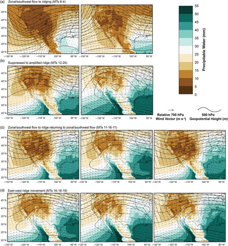
FIGURE 7     Most frequent MT progressions associated with increased wildfire activity (contours have same values as Figure 3) [Colour figure can be viewed
at wileyonlinelibrary.com]

 • Zonal or southwest flow transitioning into ridging fol-                      method for determining the NAM onset by PSA as directly
   lowed by a return to zonal or southwest flow.                                related to wildfire was also established corresponding to
 • Variation between suppressed and amplified ridging over                      observed, and to some extent predictable, atmospheric pat-
   the SWA with the ridge axis exhibiting east–west                             terns that promote increased moisture and lightning. We pro-
   movement.                                                                    vided novel results documenting MTs directly associated
                                                                                with significant wildfire episodes and NAM onset in
    If these patterns develop before the NAM onset, and thus                    the SWA.
coincide with peak fuel and atmospheric dryness, then the                           The results of this work are intended to provide decision
likelihood of significant wildfire episodes increases. A                        support information and improve understanding of
NAUSLAR ET AL.                                                                                                                                                     1553

atmospheric processes associated with NAM and their                                  Carleton, A.M., Carpenter, D.A. and Weser, P.J. (1990) Mechanisms of interann-
                                                                                         ual variability of the southwest United States summer rainfall maximum.
impact on wildfire activity. Improved understanding of this
                                                                                         Journal of Climate, 3, 999–1015.
association may benefit operational fire meteorologists and                          Cavazos, T., Comrie, A.C. and Liverman, D.M. (2002) Intraseasonal variability
managers by providing identifiable atmospheric patterns                                  associated with wet monsoons in southeast Arizona. Journal of Climate, 15,
associated with increased wildfire activity that are particu-                            2477–2490.
                                                                                     Cerezo-Mota, R., Allen, M. and Jones, R. (2011) Mechanisms controlling precip-
larly impactful on suppression resources and can lead to
                                                                                         itation in the northern portion of the North American monsoon. Journal of
overall improvements in planning and logistical strategies                               Climate, 24, 2771–2783.
(Ray et al., 2007).                                                                  Crimmins, M.A. (2006) Synoptic climatology of extreme fire-weather conditions
                                                                                         across the southwest United States. International Journal of Climatology,
                                                                                         26, 1001–1016.
                                                                                     Dominguez, F. and Kumar, P. (2008) Precipitation recycling variability and eco-
ACKNOWLEDGEMENTS
                                                                                         climatological stability—a study using NARR data. Part I: central
We would like to thank the USDA Forest Service for provid-                               U.S. plains ecoregion. Journal of Climate, 21, 5165–5186.
ing the funding (10-CS-11130206-047), and Vaisala for                                Dominguez, F., Kumar, P. and Vivoni, E.R. (2008) Precipitation recycling vari-
                                                                                         ability and ecoclimatological stability—a study using NARR data. Part II:
allowing the use of lightning data for wildfire applications.
                                                                                         North American monsoon region. Journal of Climate, 21, 5187–5203.
We would also like to thank Chuck Maxwell, John Salten-                              Doubler, D.L., Winkler, J.A., Bian, X., Walters, C.K. and Zhong, S. (2015) An
berger, and Terry Marsha for their input and advice for the                              NARR-derived climatology of southerly and northerly low-level jets over
paper. Finally, we would like to thank David Reusch and                                  North America and coastal environments. Journal of Applied Meteorology
                                                                                         and Climatology, 54, 1596–1619.
Michael Crimmins for their expertise and help on SOMs,                               Douglas, M.W., Maddox, R.A., Howard, K. and Reyes, S. (1993) The Mexican
John Abatzolgou for helping obtain and organize the MET-                                 monsoon. Journal of Climate, 6, 1665–1677.
DATA, and Andrew Joros for helping obtain and organize                               Dowdy, A.J. and Mills, G.A. (2012) Atmospheric and fuel moisture characteris-
the NARR data set. We would also like to thank the two                                   tics associated with lightning-attributed fires. Journal of Applied Meteorol-
                                                                                         ogy and Climatology, 51, 2025–2037.
anonymous reviewers for their thorough and constructive                              Ellis, A.W., Saffell, E.M. and Hawkins, T.W. (2004) A method for defining
comments, which greatly improved the manuscipt.                                          monsoon onset and demise in the southwestern USA. International Journal
                                                                                         of Climatology, 24, 247–265.
                                                                                     Evett, R.R., Mohrle, C.R., Hall, B.L., Brown, T.J. and Stephens, S.L. (2008) The
ORCID
                                                                                         effect of monsoonal atmospheric moisture on lightning wildfire ignitions in
Nicholas J. Nauslar      https://orcid.org/0000-0003-1600-6311                           southwestern North America. Agricultural and Forest Meteorology, 148,
Benjamin J. Hatchett      https://orcid.org/0000-0003-1066-3601                          1478–1487.
                                                                                     Favors, J.E. and Abatzoglou, J.T. (2012) Regional surges of monsoonal moisture
John F. Mejia      https://orcid.org/0000-0001-6727-5541
                                                                                         into the southwestern United States. Monthly Weather Review, 141,
                                                                                         182–191.
                                                                                     Gebremichael, M., Vivoni, E.R., Watts, C.J. and Rodríguez, J.C. (2007) Subme-
REFERENC ES
                                                                                         soscale spatiotemporal variability of North American monsoon rainfall over
Abatzoglou, J.T. (2013) Development of gridded surface meteorological data for           complex terrain. Journal of Climate, 20, 1751–1773.
    ecological applications and modelling. International Journal of Climatology,     Gochis, D.J. and Higgins, R.W. (2007) The path to improving predictions of the
    33, 121–131.                                                                         North American monsoon. US CLIVAR Variations, 5.
Abatzoglou, J.T. and Brown, T.J. (2009) Influence of the Madden–Julian Oscilla-      Grantz, K., Rajagopalan, B., Clark, M. and Zagona, E. (2007) Seasonal shifts in
    tion on summertime cloud-to-ground lightning activity over the continental           the North American monsoon. Journal of Climate, 20, 1923–1935.
    United States. Monthly Weather Review, 137, 3596–3601.                           Hales, J.E. (1977) On the relationship of convective cooling to nocturnal thun-
Adams, D.K. and Comrie, A.C. (1997) The North American monsoon. Bulletin                 derstorms at Phoenix. Monthly Weather Review, 105, 1609–1613.
    of the American Meteorological Society, 78, 2197–2213.                           Hall, B.L. (2007) Precipitation associated with lightning-ignited wildfires in Ari-
Adams, J.L. and Stensrud, D.J. (2007) Impact of tropical easterly waves on the           zona and New Mexico. International Journal of Wildland Fire, 16, 242–254.
    North American monsoon. Journal of Climate, 20, 1219–1238.                       Hawkins, T.W., Ellis, A.W., Skindlov, J.A. and Reigle, D. (2002) Intra-annual
Anderson, K. (2002) A model to predict lightning-caused fire occurrences. Iner-          analysis of the North American snow cover–monsoon teleconnection: sea-
    national Journal of Wildland Fire, 11, 163–172.
                                                                                         sonal forecasting utility. Journal of Climate, 15, 1743–1753.
Barlow, M., Nigam, S. and Berbery, E.H. (1998) Evolution of the North Ameri-
                                                                                     Hendon, H.H., Sperber, K.R., Waliser, D.E. and Wheeler, M.C. (2011) Modeling
    can monsoon system. Journal of Climate, 11, 2238–2257.
                                                                                         monsoon intraseasonal variability: from theory to operational forecasting.
Becker, E.J., Berbery, E.H. and Higgins, R.W. (2009) Understanding the charac-
                                                                                         Bulletin of the American Meteorological Society, 92, ES32–ES35.
    teristics of daily precipitation over the United States using the North Ameri-
                                                                                     Hewitson, B.C. and Crane, R.G. (2002) Self-organizing maps: applications to
    can regional reanalysis. Journal of Climate, 22, 6268–6286.
                                                                                         synoptic climatology. Climate Research, 22, 13–26.
Brandt, R.R. (2006) The North American monsoon system in southern Arizona.
                                                                                     Higgins, R.W., Yao, Y. and Wang, X.L. (1997) Influence of the North American
    Dissertation, Department of Geography and Regional Development, Univer-
                                                                                         monsoon system on the U.S. summer precipitation regime. Journal of Cli-
    sity of Arizona, 130 pp.
Brown, T.J. (2002) The North American “Firesoon.” Report on research opportu-            mate, 10, 2600–2622.
    nities for climate and society interactions in the North American monsoon        Higgins, R.W., Mo, K.C. and Yao, Y. (1998) Interannual variability of the
    region. In: Tucson, A.Z. , Ray, A.J. and Webb, R.S. (Eds.) Workshop on               U.S. summer precipitation regime with emphasis on the southwestern mon-
    Applications and Human Dimensions of Monsoon Research, June 18–20,                   soon. Journal of Climate, 11, 2582–2606.
    2001. Tucson, AZ: NOAA OAR, 64 pp.                                               Higgins, R.W., Chen, Y. and Douglas, A.V. (1999) Interannual variability of the
Bryson, R.A. and Lowry, W.P. (1955) Synoptic climatology of the Arizona sum-             North American warm season precipitation regime. Journal of Climate, 12,
    mer precipitation singularity. Bulletin of the American Meteorological Soci-         653–680.
    ety, 36, 329–339.                                                                Kohonen, T. (2001) Self-Organizing Maps. Berlin Heidelberg: Springer, 503 pp.
Carleton, A.M. (1986) Synoptic-dynamic character of “bursts” and “breaks” in         Kolden, C.A., Lutz, J.A., Key, C.H., Kane, J.T. and van Wagtendonk, J.W.
    the southwest U.S. summer precipitation singularity. Journal of Climatology,         (2012) Mapped versus actual burned area within wildfire perimeters: charac-
    6, 605–623.                                                                          terizing the unburned. Forest Ecology and Management, 286, 38–47.
1554                                                                                                                                                  NAUSLAR ET AL.

Lo, F. and Clark, M.P. (2002) Relationships between spring snow mass and sum-        Reusch, D.B., Alle, R.B. and Hewitson, B.C. (2007) North Atlantic climate vari-
    mer precipitation in the southwestern United States associated with the North        ability from a self-organizing map perspective. Journal of Geophysical
    American monsoon system. Journal of Climate, 15, 1378–1385.                          Research, 112, D02104.
Mathworks. (2017) Self-organizing maps. Available at: https://www.mathworks.         Sammon, J.W. (1969) A nonlinear mapping for data structure analysis. IEEE
    com/help/nnet/self-organizing-maps.html [Accessed 15th September 2017].              Transactions on Computers, 18, 401–409.
Means, J.D. (2012) GPS precipitable water as a diagnostic of the North American      Seastrand, S., Serra, Y., Castro, C. and Ritchie, E. (2015) The dominant
    monsoon in California and Nevada. Journal of Climate, 26, 1432–1444.                 synoptic-scale modes of North American monsoon precipitation. Interna-
Mejia, J.F., Douglas, M.W. and Lamb, P.J. (2015) Observational investigation of          tional Journal of Climatology, 35, 2019–2032.
    relationships between moisture surges and mesoscale to large-scale convec-       Short, K.C. (2015) Spatial Wildfire Occurrence Data for the United States,
    tion during the North American monsoon. International Journal of Climatol-           1992–2013 [FPA_FOD_20150323], 3rd edition. Fort Collins, CO: Forest
    ogy, 36, 2555–2569.                                                                  Service Research Data Archive.
Mesinger, F., DiMego, G., Kalnay, E., Mitchell, K., Shafran, P.C., Ebisuzaki, W.,    Stensrud, S.J. (1996) Importance of low-level jets to climate: a review. Journal
    Jović, D., Woollen, J., Rogers, E., Berbery, E.H., Ek, M.B., Fan, Y.,                of Climate, 9, 1698–1711. https://doi.org/10.1175/15200442(1996)
    Grumbine, R., Higgins, W., Li, H., Lin, Y., Manikin, G., Parrish, D. and             009
You can also read