IMPLEMENTATION PLAN 2022 2027 - Guam REPI Habitat Conservation Initiative - National Fish and ...
←
→
Page content transcription
If your browser does not render page correctly, please read the page content below
Guam REPI Habitat Conservation Initiative
IMPLEMENTATION PLAN
          2022 - 2027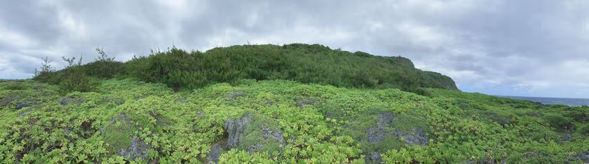
Acknowledgements
NFWF and its local liaison contractor, Galaide Group, gratefully acknowledge the time, knowledge, and
support provided by individuals and organizations that contributed significantly to this implementation
plan through their input, review, discussion, and expertise. While we cannot individually name every
contributor, we acknowledge the contributions of (in no particular order):

Jennifer Oelke Farley, Environmental Planning and Conservation, Office of the Deputy Assistant Secretary
of the Navy (Environment and Mission Readiness); Albert Thomas T. Borja, Environmental Director,
NAVFAC Marianas (NAVFACMAR) Public Works Department at Marine Corps Base Camp Blaz; Adrienne
Loerzel, Forest Enhancement Program Manager, MCB Camp Blaz, NAVFACMAR; James C. Watterson,
Natural/Marine Resources, NAVFAC HQ; Rick Salas, MCB Camp Blaz, NAVFACMAR; Dana T. Lujan, EV2,
Planning & Conservation Product Line Coordinator, NAVFACMAR; Jennifer Horeg, Conservation Resource
Program Manager, NAVFACMAR; Mario Martinez, Biologist, NAVFACMAR; Chelsa Muña‐Brecht,
Director, Guam Department of Agriculture (DOAG); Christine Camacho Fejeran, Forestry Division Chief,
DOAG, Forestry and Soil Resources Division; Ruddy Estoy Jr., Forester II, DOAG, Forestry and Soil
Resources Division; Jay Gutierrez, Chief, DOAG, Division of Aquatic and Wildlife Resources; Jeffery
Quitugua, Program Coordinator III, DOAG, Division of Aquatic and Wildlife Resources; Joseph M. Borja,
Director, Guam Department of Land Management (DLM); Jacqueline Flores, Island Team Manager, U.S.
Fish and Wildlife Service (USFWS); Toni Mizerek, Fish and Wildlife Biologist, USFWS; Michael Aguon,
Chairperson, Southern Guam Soil & Water Conservation District; John F. Reyes, Jr. Chairman, CHamoru
Land Trust Commission; and Jay Doronila, Acting District Conservationist, USDA Natural Resources
Conservation Service.

Cover photo credit: Top ‐ Taguan Landscape; Bottom left ‐ Limestone forest habitat Taguan; Bottom
right ‐ Fadang tree in Taguan (Tomas Quinata and Victor Torres)

                                                      Guam REPI Habitat Conservation Initiative | 2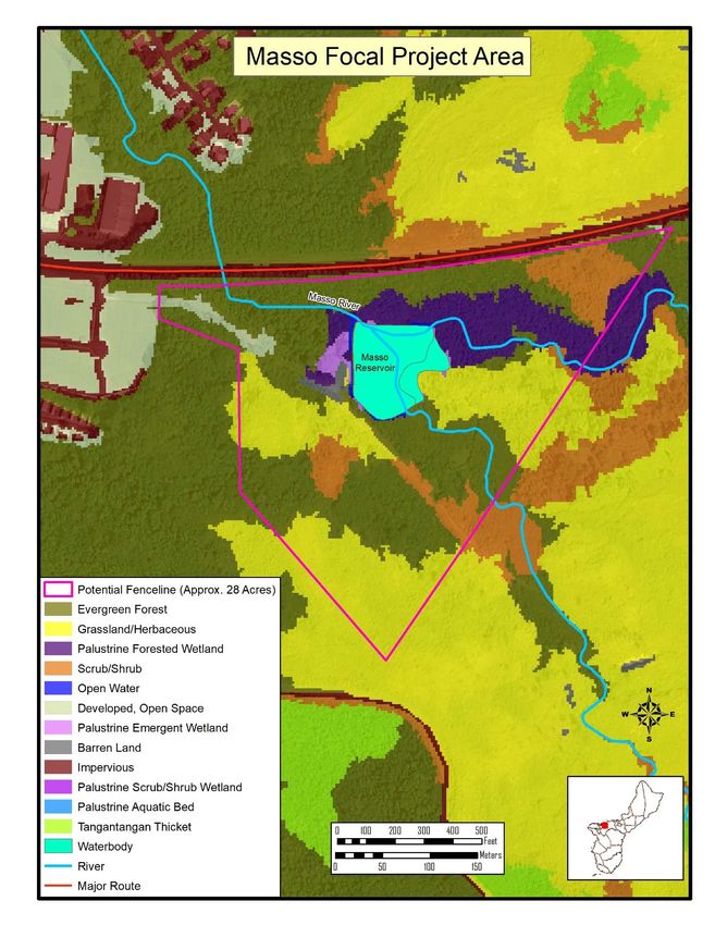
Summary
The purpose of the Guam REPI Habitat Conservation Initiative (Program) is to protect, restore, and
enhance targeted native limestone forest, ravine forest, and savanna habitats in Guam to support
conservation and recovery of federally listed and at‐risk species. Guam’s native habitats face numerous
threats from invasive plants, animals, introduced pests and disease, and habitat loss from development,
human‐caused wildfires, and extreme weather events. The Program recognizes that baseline habitat
conditions in targeted areas must be improved before species‐specific issues can successfully be
addressed.

Through a cooperative partnership under the Department of Defense (DoD) Readiness and
Environmental Protection Integration (REPI) Program, Joint Region Marianas, and the National Fish and
Wildlife Foundation (NFWF), in collaboration with Guam Department of Agriculture (DOAG), the U.S.
Fish and Wildlife Service (USFWS), and other partners, this five year implementation plan provides a
roadmap of the strategies and resources required to improve baseline conditions of targeted native
forest and habitat health. The initial conservation outcomes of the implementation plan will serve as a
proof of concept and model for future deployment of large‐scale habitat restoration actions throughout
Guam. The long‐term conservation benefits achieved through this cooperative program will support the
objectives of the Guam Forest Action Plan, Guam State Wildlife Action Plan, and the Joint Region
Marianas Integrated Natural Resources Management Plan. In the future, potential secondary phases of
the Program may build upon the habitat improvements made in the initial five years to improve the
conservation status of plant and animal species federally listed under the Endangered Species Act (ESA).

The strategies discussed in this plan do not solely represent NFWF’s view of the actions necessary to
achieve the identified conservation goals, but instead reflect the view of numerous federal, state,
academic, and organizational experts who were consulted during plan development. The Program seeks
to build trust, working relationships, and capacity with partners on Guam to ensure sustainable and
durable conservation benefits beyond the life of the implementation plan. The goals and objectives of
this plan are intended to complement ongoing conservation work performed by federal agencies, local
government, and non‐governmental organizations by synergizing efforts across the larger conservation
community and investing in areas where gaps may exist.

Conservation Need
Guam, a U.S. territory, is the southernmost island in the Mariana Archipelago and the largest island in
Micronesia, with a landmass of roughly 200 square miles and a population of 153,836 (US Census, 2020).
Guam’s tropical climate hosts rich and diverse terrestrial and aquatic species. The forests comprise over
600 species of vascular plants, with more than 100 species of trees (Guam Forest Action Plan, 2020‐
2030). The unique biodiversity found within Guam’s forests support traditional practices such as
agroforestry, preparation of traditional medicines, and the harvesting of timber for seafaring and wood
carving practices. In addition to these significant cultural and intrinsic values, Guam’s forests provide
critical ecosystem services and habitats for native, endemic, and endangered species. The economic
prosperity and preservation of the CHamoru culture are dependent on the successful recovery and
sustainable use of the island’s natural resources (Guam Forest Action Plan, 2020‐2030).

As a tropical island, Guam is surrounded by a highly valued coral reef system that contributes to one of
the most species‐rich marine ecosystems in the United States (Guam Forest Action Plan, 2020‐2030).
Over 5,100 marine species have been identified in Guam’s coastal waters, including 1,000 nearshore fish
species and 300 species of reef‐building corals (Guam Forest Action Plan, 2020‐30). Coral reef resources

                                                      Guam REPI Habitat Conservation Initiative | 3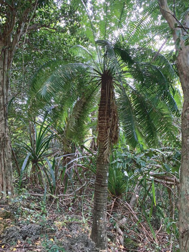
support numerous cultural and traditional uses, tourism, recreation, fisheries, and shoreline and
infrastructure protection. Traditionally, coral reef fishery resources formed a substantial part of the local
CHamoru community’s diet, which included finfish, invertebrates, and sea turtles (Coral Reef Resilience
Strategy, 2018). Guam’s marine resources, however, are facing environmental and anthropogenic
threats including land‐based sources of pollution, sedimentation, soil erosion, overfishing, recreational
use and misuse, marine debris, and impacts from climate change such as coral bleaching and ocean
acidification (Coral Reef Resilience Strategy, 2018).

Over the past 50 years, Guam has experienced tremendous growth through development, resulting in
considerable island‐wide environmental degradation. Urban and rural development, in addition to
historical and current military activities, are impacting Guam’s natural resources. Availability of suitable
habitat poses significant challenges for the recovery of Guam’s native species. Extensively altered native
forests have been converted to a mix of non‐native vegetation, while others have transitioned into
grasslands, savannas, and barren lands (Guam Forest Action Plan, 2020‐2030). Native flora and fauna
are negatively affected by the introduction of non‐native invasive plants and animals, such as the brown
tree snake (Boiga irregularis) that has driven nine of Guam’s 11 native forest birds to extinction or
extirpation, while causing significant population declines of several native lizards, bats and other bird
species (USDA National Invasive Species Information Center, 2021). Non‐native insects and pathogens
brought to Guam by humans, human‐caused grassland and forest fires, and unmanaged recreational use
of natural resources also pose significant threats. Anthropogenic threats are further exacerbated by
climate change and extreme weather events such as drought and typhoons.

This implementation plan targets three habitat types for protection and restoration that are critical to
Guam’s native wildlife and its people: 1) limestone forest, 2) ravine forest, and 3) savanna.

Limestone Forest
Limestone forests in Guam is primarily found in the northern half of the island built upon shallow
limestone soils that are nutrient‐poor, high in calcium carbonate, and highly permeable. These physical
and chemical properties influence the types of plants that can establish in this unique ecosystem and
are vital for Guam’s native forest birds, two fruit bat species, lizards, snails, and insects, including some
of those listed as endangered or threatened under the federal or Guam Endangered Species Act. Guam’s
native limestone forests are composed principally of old growth native trees and plants, with a
moderately dense canopy 10‐30 meters in height. There are limited openings within the canopy, and
understory vegetation varies from open to dense. Limestone plant communities are further broken
down into five classes: Artocarpus‐Ficus forest, Mammea forest, Cordia forest, Merrilliodendron‐Ficus
forest, and Pandanus forest (Donnegan et al. 2002). Species of limestone forest trees include: nunu
(Ficus prolixa), ifit (Intsia bijuga), dukduk (Artocarpus mariannensis), and yoga (Elaeocarpus joga). Forty‐
one percent of Guam has tree cover of which 22% is classified as native limestone forest (Guam Forest
Action Plan, 2021). These forests are a priority for public water security through the groundwater
recharge they promote. Over thousands of years, rainwater, carbon dioxide and limestone soils mix
creating freshwater aquifers.

Unfortunately, the extent and health of limestone forests are declining. In recent years, approximately
1,000 forested acres have been cleared to support military buildup, including about 80 acres of high‐
quality native limestone forest (USFS State and Private Forestry Fact Sheet, Guam 2022). The structure
of remaining forests is changing due to the presence of invasive Philippine deer (Rusa mariannus) and
feral pigs (Sus scrofa) that browse on seeds and seedlings thereby impeding the natural regeneration of
native forest plants (Wiles et al. 1999). This poor condition is further exacerbated by the loss of habitat

                                                        Guam REPI Habitat Conservation Initiative | 4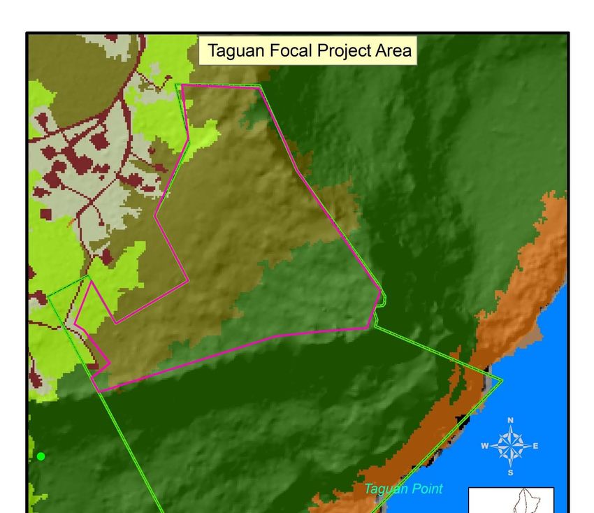
due to development, typhoons, a decline in pollinators and seed dispersers, introduction of aggressive
invasive plant species, and plant diseases exacerbate this condition (Guam Wildlife Action Plan, 2019).
Restoration of remaining forests through ungulate management, invasive plant removal, increased
native vegetation cover, and improved forest composition is critical to ensure sufficient habitat remains
available to support the conservation and recovery of protected species (Guam Wildlife Action Plan,
2019).

Ravine Forest
Ravine forests occur on steep slopes in river valleys and other topographic depressions. They are
typically found in southern Guam supported by rich volcanic soils. Ravine forests are home to numerous
native species including nunu, chosga (Phyllanthus marianensis), pago (Hibiscus tiliaceus), kafu
(Pandanus tectorius), ahgao (Premna serratifolia), chiute (Cerbera sp.), ufa (Heritiera littoralis), puting
(Barringtonia asiatica), and nonak (Hernandia labyrinthica). Ravine forests have been reduced in quality
and quantity by damage from invasive ungulates, introduced plant species such as palma brava
(Heterospathe elata), and wildfires (Guam Wildlife Action Plan, 2019).

Impacts from ungulates have resulted in severe erosion leaving arid and barren land where little natural
revegetation occurs. In response, the Department of Agriculture’s Forestry and Soil Resources Division
(FSRD) began efforts in 1978 to stabilize the landscape and improve soil quality in southern Guam by
planting non‐native acacia trees (Acacia sp.) in these badlands. In 2005, FSRD began planting native
species to transition the acacia forest to a native ravine forest. The efforts made thus far have been
anecdotally successful at stabilizing the soil, and although work to transition to native plants is still in a
trial phase and continues at a slow pace due to other competing priorities. The goal of this restoration
effort is to restore the native plant community.

Savanna Habitat
On the island, savanna is a grassland habitat on volcanic soil that is primarily found in southern Guam.
The volcanic‐dominated geology of southern Guam has relatively low permeability, and therefore the
hydrologic regime is dominated by surface water processes (Guam Forest Action Plan, 2021).
Watersheds in the south that contain savanna habitat are priority regions for public surface water
security. Currently, savanna habitat covers 20% of land area (WERI, 2021) in the southern region and is
home to many native and/or endemic plants, including Phyllanthus saffordii, hedyotis megalantha, and
is a key foraging habitat for the Mariana swiftlet (Aerodramus vanikorensis bartschi).

Frequent fires have reduced the number of native shrubs and sedges, with most areas now dominated
by swordgrass (Miscanthus sp.) and invasive bluegrass (Dicanthium sp.). On average, 4.8% of Guam’s
total land area was burned by arson or unintentionally each year between 2015 and 2020, including the
island’s savannas (USFS State and Private Forestry Fact Sheet, Guam 2022). As a result, trees were killed
and invasive grasses expanded their footprint by encroaching on surrounding forested areas (Stone,
1970). Exposed earth from fires and altered vegetation types result in increased erosion that degrades
surface water quality, threatens domestic water supply, and damages fragile coral reef ecosystems
downstream (Guam Forest Action Plan, 2021). Savanna habitat deterioration is further exacerbated by
off‐road vehicles that erode bare soil especially during the rainy season.

Current Conservation Context
The DOAG Division of Forestry and Soil Resources (DFSR) provides a critical role in improving forest

                                                         Guam REPI Habitat Conservation Initiative | 5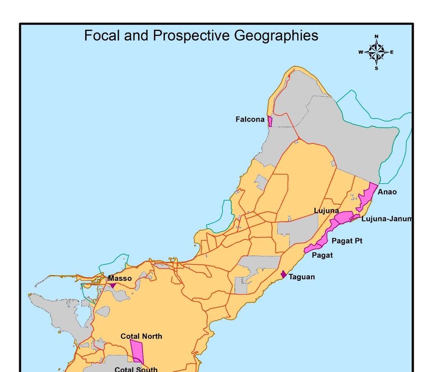
health on Guam through forest stewardship, fire prevention and control programs, and watershed‐scale
restoration efforts to address declining water quality issues impacting nearshore coral reefs. Given
limited availability of resources, the DFSR has predominantly focused on erosion control and fire
protection of savanna habitats utilizing local government appropriations and federal grants from the
U.S. Forest Service (USFS). For the past 40 years, the primary strategy foresters have utilized is the
outplanting of non‐native acacia trees to mitigate erosion caused by the 400 wildfires that occur on
average annually. Although acacia plantings have successfully stabilized soils, the process to convert
large old acacia stands to native ravine forest or a savanna complex remains untested at large scales.

Given the scale of protection and restoration required for savanna habitats, coupled with limited
funding, little to no forest enhancement work is currently conducted in the limestone and ravine forest
habitats on Government of Guam lands. On lands under federal jurisdiction, the Department of the Navy
supports forest enhancement efforts including invasive plant management, ungulate eradication in
fenced enclosures, and experimental brown tree snake control. The USFWS and National Park Service
also manages limestone forest habitat for listed species on National Wildlife Refuge and Park Service
lands, and promotes native outplanting, invasive species control, and propagation of host plants for
listed butterflies.

Funding made available through this Program will be leveraged to address gaps in current conservation
strategies such as ungulate management, non‐native plant control, native plant establishment, wildfire
prevention, baseline data collection, and public education and engagement about targeted watersheds,
all of which will protect limestone forest, ravine forest, and savanna habitats.

Geographic Focus
Program partners, including NFWF, Galaide Group, Department of the Navy (DON), USFWS, and the
Guam Department of Agriculture, collaborated to identify focal geographies to target conservation
investments through the Guam REPI Habitat Conservation Initiative. In addition, members of the local
conservation community were asked to provide input for various sites which were then scored and
ranked based on‐site selection criteria. The site selection criteria included the following considerations:
    1) legal protections in place or a high likelihood of long‐term protection,
    2) current presence of at least one federally listed species and potential benefit to the greatest
       number of listed species,
    3) early habitat outcomes possible within one to five years,
    4) connectivity to other managed conservation areas,
    5) reasonable physical access for project implementer without posing undue risk to safety or
       requiring specialized transport,
    6) existing or planned conservation work supported by partners,
    7) long‐term commitment by partners to support the Program’s investments, and
    8) other considerations such as importance of site for cultural resources, level of public support
       and community education opportunities.

The geographic focus of this implementation plan encompasses important limestone forest, ravine
forest, and savanna habitats in undeveloped areas on Government of Guam lands. The limestone forest
of Taguan (Figure 1) and the ravine forest and savanna habitat of Masso (Figure 2) were selected as
initial focal geographies that meet site selection criteria. The sites identified have diverse ecosystems,

                                                        Guam REPI Habitat Conservation Initiative | 6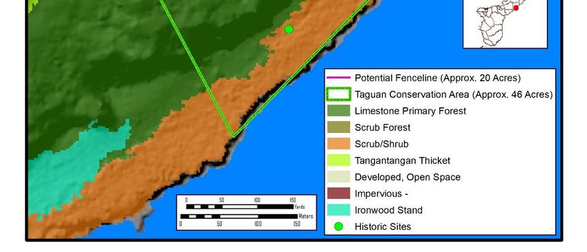
unique geographic features that support specialized native flora and fauna, and are likely to result in
measurable outcomes through initial conservation actions within the five‐year Program term. As focal
geographies, these sites are deemed to have a higher likelihood of long‐term protection than other sites
considered, and broader opportunities for collaboration and cost‐sharing among conservation
practitioners in Guam.
Table 1 describes the two focal geographies, the anticipated conservation activities, and the potential
habitat benefits for listed species that are either currently found within the site or have potential to
benefit from habitat improvements. Surveys, assessments, and partner recommendations will inform
the selection of focal project areas within these focal geographies. This implementation plan also
includes prospective geographies (Figure 3) that are important and desirable areas for larger‐scale
limestone forest conservation (Table 2), but do not yet satisfy the site selection criteria for site
protection. Projects may occur in these prospective geographies to assist with securing site protections
and acquiring baseline site conditions to facilitate establishing habitat‐specific objectives required to be
considered a focal geography.
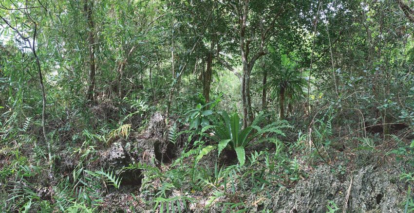
Taguan
Taguan is a 46‐acre parcel along the northeastern coastline of Guam and includes an important portion
of the remaining intact limestone forest that extends north toward Andersen Air Force Base (Figure 1).
Taguan is a lone parcel bordered on three sides by privately owned property that has been or is in the
process of being developed. Invasive species, ungulate damage, and the loss of seed dispersers pose the
greatest threats to habitat recovery in Taguan. The site faces other, less impactful threats from public
use, but due to its topography public visitation is thought to be low. Taguan hosts numerous native plant
and animal species, is capable of supporting additional listed species (Table 1), and was selected as the
only limestone forest owned and protected by the Government of Guam with relatively reasonable
accessibility. Additionally, in 2016 the property was designated by Guam Public Law 33‐210 as a
Biodiversity Conservation Easement for the purpose of transplanting and cultivating medicinal plants,
further solidifying the sites protection status.
Masso
Masso is a 29‐acre site in central Guam located adjacent to a Naval Reservation and the Navy’s fuel
farm. The site contains ravine forest and savanna habitat, and a portion of the Masso River, including a
constructed reservoir that supports endangered Mariana common moorhens (Gallinula chloropus
guami) (Table 1). Fire, invasive species, excess sediment accumulating in the reservoir, and reservoir
overflow events resulting in sedimentation to downstream coral habitat pose the greatest
environmental threats. Since the site is relatively small, installation of exclusionary ungulate fencing
could successfully mitigate ungulate damage and improve forest and habitat health.
The Masso River flowing through this site is a known contributor of nutrient and sediment transport,
directly emptying into the Piti Bay Marine Preserve, impacting a shallow lagoon complex resembling a
barrier reef that is the most diverse of the 10 territory and federal Marine Protected Areas in Guam
(NOAA 2009). As one of the most active Guam conservation locations, Masso is currently undergoing
regular forest management to mitigate threats and risks to its natural resources in support of the Piti‐
Asan Watershed Management Plan (2012). The site’s ease of access and variety of species attracted to
the reservoir make Masso a popular destination for school field trips and other educational outreach
events. Conversion of large stands of invasive trees, removal of other invasive plants, and outplanting a
wide variety of native plants would improve habitat quality, diversity, and water quality at this site.
Guam REPI Habitat Conservation Initiative | 7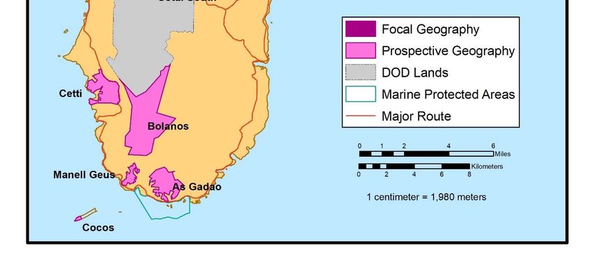
Table 1: Focal Geographies by Habitat and Potential Species to Benefit

    Focal        Anticipated       Listed Species          Potential Species to Benefit
    Geography    Conservation      (Currently Found        (Not Currently Found on Site)1
                 Action            on Site)
    Taguan       Limestone         Mariana eight‐          Guam Micronesian
                 forest            spot butterfly          kingfisher (Todiramphus
                 restoration       (Hypolimnas             cinnamominus cinnamominus)
                                   octucula                ko’ko’/Guam Rail (Gallirallus owstoni)
                                   mariannensis);          fanihi/Mariana fruit bat (Pteropus mariannus)
                                   Fadang (Cycas           Mariana swiftlet (Aerodramus vanikorensis
                                   micronesica)            bartschi)
                                                           Tabernaemontana rotensis
                                                           Serianthes nelsonii
                                                           Tuberolabium guamense
                                                           Bulbophyllum guamense
                                                           Dendrobium guamense
                                                           Maesa walkeri
                                                           Heritiera longipetiolata
                                                           Partula radiolata
                                                           Partula gibba
                                                           Samoana fragilis

    Masso        Ravine forest     Mariana common          Guam Micronesian
                 and savanna       moorhen                 kingfisher (Todiramphus
                 habitat           (Gallinula              cinnamominus cinnamominus)
                 restoration       chloropus guami)        ko’ko’/Guam rail (Gallirallus owstoni)
                                                           Fanihi/Mariana fruit bat (Pteropus mariannus)
                                                           Mariana swiftlet (Aerodramus vanikorensis
                                                           bartschi)
                                                           Fadang
                                                           Tuberolabium guamense
                                                           Bulbophyllum guamense
                                                           Dendrobium guamense
                                                           Heritiera longipetiolata
                                                           Phyllanthus saffordii
                                                           Hedyotis megalantha
                                                           Partula radiolata
                                                           Samoana fragilis

1
 “Potential Species to Benefit” is listed as an attribute of the focal geographies to provide a prospective outlook of
the Threatened and Endangered species that could benefit from habitat enhancement.

                                                             Guam REPI Habitat Conservation Initiative | 8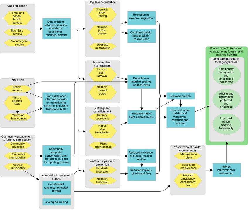
Table 2: Prospective Geographies and Planned Actions

 Prospective      Planned Actions
 Geographies
 Anao and         Support efforts to secure long‐term legal conservation status for limestone forest
 Pagat            sites, such as parcel surveys to identify property boundaries. DOAG and local
                  partners are pursuing long‐term legal conservation status for the sites. Once legal
                  protection is secured, the sites would be eligible as a focal geography, although
                  other site selection criteria may need to be considered such as access and partner
                  support.

                  Additional activities may include site preparation to inform habitat‐specific
                  objectives for the sites in anticipation of securing site protection, such as baseline
                  forest health.
 Pilot project:   Support a pilot project to assess the feasibility and methodology for transitioning
 site(s) to be    non‐native acacia forest to native vegetation at a landscape scale. Pilot project
 determined       scope, goals, and location(s) will be developed through engagement and
                  collaboration with Program partners.

                                                       Guam REPI Habitat Conservation Initiative | 9
Figure 1: Taguan Focal Project Area Guam REPI Habitat Conservation Initiative | 10
Figure 2: Masso Focal Project Area

Guam REPI Habitat Conservation Initiative | 11
Figure 3: Focal and Prospective Geographies

Guam REPI Habitat Conservation Initiative | 12
Program Goals and Objectives
The vision of the Program’s implementation plan is to advance the conservation, restoration, and
enhancement of Guam’s forest and savanna habitats to establish precursory conditions towards
improving the baseline status of federally listed threatened and endangered species (T&E). This plan
identifies habitat‐specific objectives for limestone forest, ravine forest, and savanna habitat that can be
achieved over the next five years. The focal and prospective geographies of this plan and their
respective strategies will serve as a proof of concept providing a model for the future deployment of
larger‐scale restoration actions throughout Guam. The improvement of baseline ecological status of
plant and animal species federally listed under the ESA is beyond the current scope of the Program2.

The primary objectives of the Program are to improve native forest and habitat health while increasing
habitat fragment sizes in 20 acres of old growth limestone forest in Taguan (Figure 1), 28 acres of ravine
forest and savanna habitat in Masso (Figure 2). Activities anticipated to be performed within and
surrounding future ungulate‐proof fenced units include addressing habitat threats from non‐native
ungulates, invasive plants, and wildfire. Predator control of brown tree snake, cats, and rats, as well as
biosecurity threats such as little fire ant (Wasmannia auropunctata), coconut rhinoceros beetle (Oryctes
rhinoceros), cycad scale (Aulacaspis yasumatsui), and brown root rot (Phellinus noxius), are beyond the
scope of the current Program. The Program aims to improve overall habitat conditions before targeting
species‐specific issues. Baseline information of general forest and habitat health for the focal
geographies selected in this plan are limited or not available. The goals identified below are based on
input from local experts and should be treated as preliminary. As projects progress, it is expected that
baseline data will be gathered that may result in reassessment of goals and objectives.

The secondary goal of the Program is to address site selection criteria required for prospective sites to
become focal geographies within this plan. The Program will support efforts to secure long‐term legal
conservation status for Anao and Pagat (Figure 3) which may include parcel surveys to identify property
boundaries. The Program will seek to fund a pilot study to assess the feasibility and develop a process to
transition non‐native acacia forests to native forest habitat at a landscape scale.

1) Objective: Establish forest and habitat health baseline conditions to inform future management
   actions, support acquisition of environmental compliance permits necessary to implement the
   Program’s strategies, and assist with securing site protection.
   a) Conduct on‐site surveys to determine the current baseline status of forest and habitat health
       within:
       i) 28 acres in Masso
       ii) 20 acres in Taguan
       iii) A minimum of 10 acres in Anao
       iv) A minimum of 10 acres in Pagat
   b) Conduct parcel boundary surveys of Taguan, Anao, and Pagat
   c) Conduct archaeological studies as required by the State Historic Preservation Office within
       Masso, Taguan, Anao and Pagat

2) Objective: Prevent forest and habitat degradation by invasive ungulates.

2
 Future iterations of the implementation plan may include T&E species‐specific goal(s). Federally listed plant
species are not required to be outplanted in the first 5‐years of the Program.

                                                           Guam REPI Habitat Conservation Initiative | 13
a) Install approximately 0.98 miles (5,170 linear feet) of ungulate‐proof, access‐friendly fencing in
Masso and 0.9 miles (4,800 linear feet) in Taguan
b) Protect 28 acres from ungulates within fenced management units in Masso and 20 acres in
Taguan
c) Remove 100% of ungulates within Masso and Taguan fenced management units
d) Maintain 0% signs of ungulate presence within Masso and Taguan fenced management units
3) Objective: Reduce invasive plant presence.
a) Remove invasive plants from 28‐acre fenced management unit in Masso
b) Remove invasive plants from 20‐acre fenced management unit in Taguan
4) Objective: Improve native plant coverage and diversity.
a) Increase native plant cover by 30% within fenced management units in Masso and Taguan
b) Increase native plant diversity by 25% within fenced management units in Masso and Taguan
5) Objective: Reduce risks of fire to forests and habitats.
a) Establish and maintain approximately 0.53 miles (2,800 linear feet) of firebreaks in Masso
6) Objective: Conduct a proof of concept study to assess the feasibility and process to transition non‐
native acacia forest to native vegetation at a landscape scale.
a) Develop 1 workplan
7) Objective: Increase community and agency engagement relating to management of focal project
areas.
a) Conduct 20 public education events (4 per year) to inform the community about focal project
areas
b) Engage volunteer organization(s) to assist with 10 restoration events (2 per year) to solicit public
participation at the focal project areas
c) Facilitate the engagement of 8 government agencies participating in the Program
8) Objective: Maintain improvements to environmental baseline conditions of focal project areas to
preserve benefit to native species.
a) Establish 1 program emergency contingency fund to be held in reserve to address unforeseen
damage or destruction of Program investments from extreme weather events
Implementation Plan
The following strategies are expected to benefit limestone forest, ravine forest, and savanna habitats.
NFWF will fund projects contributing to the goals and objectives described in this document. Only native
plant species will be planted through restoration activities. The results chain in Figure 4 provides a
model for how the collective strategies are predicted to contribute to the identified conservation
objectives.
Strategy 1: Site Preparation
1.1 Forest and habitat health surveys – Determine current forest and habitat conditions and
trends, including resilience to disturbances, within focal project sites and prospective
geographies. Information from surveys will inform priority management actions and be used
Guam REPI Habitat Conservation Initiative | 14to measure Program progress and impact. There currently is insufficient information and
data available to serve as a reference for measuring programmatic performance, and to
support permit applications. Baseline forest and habitat health should be established before
project implementation occurs and after project completion to document changes in site
conditions. Utilization of remote imagery can be a cost‐effective means to document habitat
change. When practical and appropriate, baseline data collection should be done
opportunistically when project implementors are at project sites to improve cost
effectiveness. Types of surveys may include photographic documentation particularly from
fixed positions, measurements of native and invasive plant species, size, density, and canopy
cover; classification of vegetative types and structure; ungulate density and damage
assessments; and invasive animal3, pest3, and plant disease3 types, occurrence, and
distribution.
1.2 Boundary surveys – Conduct parcel boundary surveys to formally define and record the
limits of focal and prospective Program sites. Install boundary survey monuments (as
necessary) to clearly mark parcel boundaries. Land surveys will be particularly important for
fence installation activities and perimeter firebreak establishment since these activities have
the potential to encroach on neighboring parcels.
1.3 Archaeological studies – In consultation with the Guam State Historic Preservation Office,
obtain permits and clearances to implement restoration and protection strategies, such as
the installation of ungulate‐proof fencing and native outplantings.
Strategy 2: Ungulate depredation
2.1 Installation of ungulate‐proof fencing – Install site appropriate fencing designed primarily
to exclude invasive deer and feral pigs that are impacting forest health conditions. Fences
will be designed to allow human access and preserve public access while preventing
reintroduction of invasive ungulates. Buffer zones along the fence perimeter will need to be
established to aid in proper monitoring and maintenance4 of the fence.
2.2 Maintain public access – Continue to provide public access for appropriate recreational,
educational, cultural, and management use within fenced management units. Fencing will
be designed to maintain public access via trap gates or other ingress and egress devices that
ensure entry points cannot be left open to ungulate intrusion.
2.3 Invasive ungulate depredation – When ungulate fencing is installed, subsequent removal of
100% of ungulates from within the fenced areas is required and must be accomplished
within a short time frame. If fencing cannot be installed or is undesirable based on site‐
specific conditions, alternative methods for population management may be deployed such
that there are minimal impacts to forest restoration activities. The development of
monitoring and maintenance plans to achieve depredation goals, track progress, and ensure
long‐term sustainability will be necessary. Specific ungulate management activities may
3
Program objectives do not encompass addressing invasive animals (other than ungulates), pests and plant
disease.
4
Funding support to maintain ungulate‐proof fences built with Program funds is beyond the scope of this five‐year
program. DOAG is committed to the long‐term maintenance of installed fences.
Guam REPI Habitat Conservation Initiative | 15include: 1) promote and encourage safe public hunting of invasive deer and wild pigs, 2)
controlled removal through traps for areas that are not suitable for public hunting activities
or when hunters are unable to remove animals within a designated timeframe, and 3)
contracting with a public or private sector wildlife control entity.
Strategy 3: Invasive plant management
3.1 Invasive plant removal – Removal of non‐native plants that interfere with, or out‐compete,
native plants. In areas with a high population density of non‐native trees, the strategy will
require systematic conversion to native trees to avoid total deforestation. Strategies include
mechanical and chemical removal of invasive trees, vines, and other non‐native plants.
3.2 Maintain treated acres – Develop monitoring plans, monitor, and perform preventative
maintenance activities to discourage reestablishment of non‐native plants post‐treatment.
Project implementors will use the most current and available best practices to avoid
accidental introduction(s) of new biosecurity threats and will monitor treated acres for
current and emerging biosecurity threats such as little fire ant, coconut rhinoceros beetle,
cycad scale, and brown root rot. If identified within focal project areas, Program
implementors will promptly notify appropriate management agencies. Project implementors
will be tasked with identifying and incorporating biosecurity threats into monitoring and
maintenance plans that are developed to ensure long‐term sustainability.
Strategy 4: Native plant establishment
4.1 Support native plant nursery operations – Support propagation of native tree species in
controlled environments until they are large enough to survive transportation and
outplanting in focal project areas. Activities may include seed collection, propagation,
associated materials and supplies (pots, soil, fertilizer, irrigation systems), and maintenance
of nursery facilities that are necessary to support propagation of plants that will be
outplanted at focal project areas.
4.2 Native outplanting methods – Utilize site appropriate strategies for planting native plants at
focal project areas that take into consideration environmental conditions, optimum timing,
site preparation, and planting techniques.
4.2.1 Direct outplanting – Prepare areas in potentially five‐acre increments where
nursery grown native trees will be outplanted 10 feet apart throughout focal
project areas. Tree spacing will aim to achieve canopy cover to naturally
suppress invasive grasses and weeds that may require active vegetation
management until the native canopy is established. Canopy cover is important
to help retain soil moisture to facilitate the composting of fallen leaves and
other biological material that will in turn produce nutrient rich soil suitable for
natural native plant regeneration.
4.2.2 Raised bed tree planting – Minimize the impact to potential historic and
archaeological resources by avoiding ground disruption from digging to outplant
trees. Strategies include planting native seeds and seedlings in raised beds or
mounds laid atop the existing ground surface.
Guam REPI Habitat Conservation Initiative | 164.2.3 Seed dispersal – Strategies include selective broadcasting of native seeds on the
forest floor by manual distribution.
4.2.4 Stump overplanting – Strategies includes boring a hole through the stump of a
removed invasive tree and outplanting native species in the bore hole with
backfilled soil.
4.2.5 Epiphyte planting – Strategies include planting native plants on the surface of
native tree species outside the reach of ungulates.
4.3 Post‐planting establishment period and maintenance – Improve outplant survival and
growth by reducing threats from competing plants and pests, invasive ungulates, poor soil
quality, and limited water resources. Monitor native plant cover and diversity to track
progress towards habitat health outcomes. Strategies may include weed control,
maintenance of ungulate‐proof fencelines and prompt removal of ungulates after intrusion,
application of fertilizers and mulch to supplement soil conditions, installation of shelters and
shading, and supplemental watering.
Strategy 5: Wildfire mitigation and prevention
5.1 Establish and maintain firebreaks – In coordination with DOAG, establish new firebreaks
and maintain existing firebreaks along designated perimeters of the focal geographies.
Designated firebreak perimeters will consider topography, accessibility, common points of
fire origin, wind, composition of tree and plant species within the conservation area, and
other critical factors necessary to isolate fire and limit damage in the event of a fire within
or near Program sites.
Strategy 6: Proof of concept study (acacia to native transition)
6.1 Removal of non‐native trees – Determine a safe, effective, and efficient process for
removing non‐native acacia trees in former badland areas without substantially increasing
soil erosion. Strategies may include returning organic matter to the soil to improve
conditions in badland areas while reducing soil erosion events.
6.2 Conduct native species trials – Establish methods for seed collection, propagation and
outplanting of native pioneer plant species that thrive in nutrient‐depleted soils resulting
from decades of wildfires and ungulate browsing. Trials may focus on varying site
preparation strategies such as fertilization, mulching, and maintenance. Outplantings will be
evaluated for survivorship and growth in site specific conditions in the field. Native species
that consistently perform well and meet management objectives may be considered for
larger landscape‐level native reforestation. Trial species may include species such as aghao,
lada (Morinda citrifolia), and screwpine (Pandanus spp.).
6.3 Workplan development – Outline the goals, objectives, preferable site conditions, steps
necessary, and sequencing of events to transition acacia dominant forests to native
vegetation at a landscape scale. Workplan should include resource and cost estimates, best
management practices, and implementation timelines.
Guam REPI Habitat Conservation Initiative | 17Strategy 7: Community engagement and agency participation
7.1 Community education – Prepare public education materials describing the Program, its
purpose, importance, projects, and ways in which the community can participate.
Communicate the detrimental impacts of wildfire, invasive plants, animals, pests, and
disease on native ecosystem health. Educational topics may include fire prevention and
safety, value of ungulate‐proof fencing and removal, and best practices for biosecurity
controls such as stopping the spread of invasive little fire ants and coconut rhinoceros
beetle into focal project areas. Outreach approaches may include school presentations,
training seminars, signage and informational plaques, public safety announcements, social
media, and advertisements.
7.2 Community participation – Engage the community in site protection and restoration to
establish a sense of ownership in conserving essential habitats within focal geographies,
where successes can be celebrated with others. Encourage stakeholders to guard and
protect focal project sites by reporting misuse, and by building community support of
conservation strategies and sharing information of their importance. Prior to
implementation of projects that could affect recreational or cultural activities, a Public
Service Announcement through multiple media outlets and a 45‐day review period shall be
afforded to the public for consideration. Participating approaches may include community
tree planting and invasive plant removal events, school field trips, and public hunting
engagements.
7.3 Agency participation – Support relationship and partnership building among federal,
territorial, and local government agencies, and between government agencies, non‐profit
organizations, indigenous‐based organizations, educational institutions, businesses,
landowners, and community members. Facilitate meetings with agency partners to establish
clear and open lines of communication. Establish a collaborative advisory team to review
and evaluate proposals submitted through the Program’s Request for Proposals (RFP)
process. As more information becomes available throughout the life of the Program, work
with agency partners to identify, revise, and prioritize strategies and projects for
implementation. Leverage public and private funds to support both the Program’s strategies
and complementary conservation and recovery efforts being implemented by partners for a
coordinated response to addressing threats to Guam’s natural resources. Seek strong local
partnerships that leverage additional funds to preserve habitat improvements and maintain
Program investments in perpetuity.
Strategy 8: Preservation of habitat improvements
8.1 Program emergency contingency fund – The Program will work with partners to establish a
Program Emergency Contingency Fund (PECF) that shall serve as a reserve fund and financial
security for the Program funded conservation investments and improvements to habitat
baseline conditions. Contingencies that may arise after implementation of Program
strategies will be addressed using funds deposited into the PECF. Contingencies that may be
addressed through funding from the PECF may include damage to ungulate‐proof fencing
caused natural disasters, destruction to native outplantings from wildfires, and other
Guam REPI Habitat Conservation Initiative | 18unforeseen funding needs that arise. The use of these funds shall be subject to approval by
DON and NFWF. The PECF shall be tracked separately from all other financial accounts
associated with the Program.
Long‐Term Sustainability
The implementation strategies described in this plan will require adequate long‐term maintenance and
management of the Program’s investments to ensure benefits are achieved and sustained over time.
DOAG is committed to the long‐term maintenance of all investments associated with this Program.
Existing efforts by DOAG include ungulate control, fire prevention and active fire suppression, invasive
plant removal, replacement of diseased and damaged trees, reforestation, and proactive prevention of
new introduced invasives. While all activities are dependent on unsecured funding, DOAG will continue
its ongoing workplans for Masso, incorporate the maintenance of new ungulate‐proof fencing, and
expand management into Taguan. As funding and staff allow, all work completed through this Program
will be maintained in perpetuity.
For the Program and its partners to better understand the extent of resources needed to support long‐
term maintenance, project implementors will be asked to describe the required maintenance activities
as part of their proposal. In addition, project implementors may be asked to provide estimated
maintenance costs, a list of long‐term partners, parties responsible for implementation and oversight,
and plans to secure resources for long‐term maintenance. Implementation strategies may further be
informed by grantee analysis and can be used to refine workplans, approaches, and budgets to ensure
cost effectiveness and programmatic success.
Permits
The following permits and approvals may be required to complete the strategies outlined in this
implementation plan.
Estimated
Permit Type Approval
Statute Time Submitted by Awarded to
Authority
Required
National
Guam State
Historic
Historic
Historic Preservation
Preservation 6 Months Grantee Grantee
Preservation Act, Section
Office
106 Historical
(GSHPO)
& Cultural
Coastal Zone
Bureau of
Management
Statistics and
Federal Act Section
Plan ‐ Guam 2 Weeks Grantee Grantee
Consistency 307(c)(1) and
Coastal
15 CFR Part
Management
930
Guam REPI Habitat Conservation Initiative | 19Estimated
Approval
Permit Type Statute Time Submitted by Awarded to
Authority
Required
National U.S.
Environmental Environmental
83 Stat. 852 2 Months DON DON
Policy Act Protection
(NEPA) Agency (EPA)
10 Guam
Guam Code
Environmental Annotated
Protection GEPA (GCA) 1 Month Grantee Grantee
Agency Chapters 45‐
(GEPA) 54B, 76, 76A,
90
21 GCA
Guam Chapter 63
Seashore Guam
Protection GSPC Territorial 2 Weeks Grantee Grantee
Commission Seashore
(GSPC) Protection
Act of 1974
Guam
Tree cutting/ Department
Depredation of Agriculture 5 GCA
1 Week Grantee Grantee
(DOAG) Chapter 60
U.S. Fish and
Wildlife Section 7,
Section 7 Service Rare, 2 to 4.5
DON DON
Consultation Threatened & Months
Endangered
Guam REPI Habitat Conservation Initiative | 20Grantees will be required to secure any and all applicable permits required for each proposed action prior
to the execution of the proposed action and prior to incurring any associated costs.
Monitoring & Evaluating Performance
Performance of the Program will be assessed at both project and program scales. At the project scale,
individual grants will be required to track relevant metrics from Table 3 for demonstrating progress on
project activities and objectives and to report out on them in their interim and final programmatic
reports. At the program scale, broader habitat objectives will be monitored through targeted grants,
existing external data sources, and/or aggregated data from relevant grant projects, as appropriate. In
some cases, course corrections, in coordination with partners, may be warranted as new information
becomes available and as funding support fluctuates.
Table 3. Program Metrics
Baseline Goal Data
Objective Focal Habitat Metrics
(2021) (2026) source(s)
# of acres with baseline
forest and habitat health 0 40 acres Grantees
conditions established
Limestone forest # of archeological surveys
0 3 Grantees
completed
# of boundary surveys
Site preparation 0 3 Grantees
completed
# of acres with baseline
Ravine forest forest and habitat health 0 28 acres Grantees
and savanna conditions established
habitat # of archeological surveys
0 1 Grantees
completed
# of miles of ungulate‐proof
0 0.9 miles Grantees
fencing installed
# of acres protected
(by installing ungulate‐proof 0 20 acres Grantees
Limestone forest fencing)
% of ungulates removed 0 100% Grantees
Reduce signs of ungulate
TBD5 0 Grantees
presence to 0
Ungulate
# of miles of ungulate‐proof
depredation 0 0.98 miles Grantees
fencing installed
# of acres protected
Ravine forest (by installing ungulate‐proof 0 28 acres Grantees
and savanna fencing)
habitat % of ungulates removed 0 100% Grantees
Reduce signs of ungulate
TBD5 0 Grantees
presence to 0
5
The current percentage of signs of ungulate presence at these locations are not yet know, and will be informed
by assessment of baseline site conditions.
Guam REPI Habitat Conservation Initiative | 21Table 3. Program Metrics (Continued)
Baseline Goal Data
Objective Focal Habitat Metrics
(2021) (2026) source(s)
# of acres of restored
0 20 acres Grantees
(invasive plants removed)
Limestone forest
% of restored acres
0 50% Grantees
Invasive plant maintained annually
management # of acres of restored
Ravine forest 0 28 acres Grantees
(invasive plants removed)
and savanna
% of restored acres
habitat 0 50% Grantees
maintained annually
# of acres restored
0 20 acres Grantees
(native plants planted)
Increase native plant cover by
Limestone forest 0 30% Grantees
30%
Increase native plant diversity
Native plant 0 25% Grantees
by 25%
cover and
diversity # of acres restored
0 28 acres Grantees
(native plants planted)
Ravine forest
Increase native plant cover by
and savanna 0 30% Grantees
30%
habitat
Increase native plant diversity
0 25% Grantees
by 25%
# of miles of firebreaks
Wildfire Ravine forest 0 0.53 miles Grantees
established
mitigation and and savanna
# of miles of firebreaks
prevention habitat 0 0.53 miles Grantees
maintained
Acacia to native # of studies completed 0 1 study Grantees
Proof of
vegetation
concept study # of workplans created 0 1 workplan Grantees
transition
# of public education events 0 10 events Grantees
Limestone forest
# of volunteer events 0 5 events Grantees
Community Ravine forest # of public education events 0 10 events Grantees
engagement and savanna
and agency habitat # of volunteer events 0 5 events Grantees
participation
All focal # of governmental entities NFWF/
0 8 entities
geographies participating Grantees
Preservation of
All focal # of Program Emergency
habitat 0 1 fund NFWF
geographies Contingency Fund
improvements
Guam REPI Habitat Conservation Initiative | 22Risk Assessment
Risk is an uncertain event or condition which, if it occurs, could negatively affect a plan’s objectives.
Seven risk categories were assessed to determine the extent to which they could impede progress
towards the strategies and goals over the next five years. The following table identifies primary risks to
success and describes strategies that will be implemented to minimize or avoid those risks, where
applicable.
RISK
RATING RISK DESCRIPTION MITIGATING STRATEGIES
CATEGORY
Early coordination with relevant federal
Impacts to project schedules from and state agencies to ensure permitting
delayed compliance processes. Public law applications are complete and ready for
protects Taguan from future review including required data and site
Regulatory
High development, but landowner could information. Build sufficient time into
Risks
exercise right to farm medicinal plants project schedules. Communicate with
that may conflict with conservation CHamoru Land Trust Commission to
strategies. better understand future plans in
Taguan.
No current conservation work being done
at Taguan by DOAG. Limited local funding Once investments are made, DOAG
to maintain sites after project pledges to commit to maintaining
Financial Risks Moderate completion. Fires could divert resources. investments long term. Seek alternate
High demand for building materials could funding sources. Establish long‐term
impact fence costs and delay maintenance fund.
construction.
Provide supplemental irrigation for
Climate change impacts and long‐term
native outplantings for establishment
threats:
period, when necessary. Support
‐ extended dry season affects
wildfire prevention and response.
survivorship of outplantings and overall
Environmental Support wildfire and biosecurity
Moderate ecosystem health
Risks education and outreach. Establish
‐ increased wildfire risk
contingency fund to protect habitat
‐ damage from extreme storm events
improvements made through Program
‐ accidental and deliberate introduction
investments from extreme weather
of new invasive plants and pests
events.
Limited or non‐existing baseline
Establish environmental baseline
information (e.g., T&E species, volume of
Scientific Risks Low conditions through surveys. Support
invasive plants) could impact objectives,
opportunistic data collection.
strategies, and project locations.
Competing land use conflicts. Public
opposition to fence installations, Support community outreach,
Social Risks Moderate
ungulate depredation, and access to engagement, and education.
sites.
Guam REPI Habitat Conservation Initiative | 23RISK
RATING RISK DESCRIPTION MITIGATING STRATEGIES
CATEGORY
Focal geographies of this plan are
unlikely to face pressure to change public
law to allow development, but land
surrounding sites could be developed, Development outside of focal sites will
Economic Risks Low
degrading habitat corridors. Ancestral not impact program implementation.
property right claims have been granted
on portions of Taguan. Masso is under
the jurisdiction of DOAG.
Support capacity building and training.
Utilize subcontractors to increase
capacity. Continue to work closely and
Project implementors may not have engage regularly with agency partners.
enough labor resources to support Transparency on the influence and roles
multiple concurrent projects. Limited Program partners have relating to key
Institutional
Moderate qualified contractors and archaeological topics of consideration including
Risks
firms on‐island. Conflicting perspectives program strategy/prioritization (DON),
among Program partners on best project planning/scope development
practices and priority actions. (NFWF), optimization of and metrics for
quantitative benefit to listed species
(USFWS), and land use/long‐term
maintenance (DOAG).
Guam REPI Habitat Conservation Initiative | 24Figure 4. Results chain depicting the relationship of various strategies (yellow hexagons) within the implementation plan to each other, to the
intermediate results (blue boxes) and ultimately to the Program goal to conserve, restore, and enhance Guam’s limestone forest, ravine forest, and
savanna habitat (green ovals).
Guam REPI Habitat Conservation Initiative | 25Budget
The following budget shows the estimated costs to implement the implementation plan activities. This
budget reflects NFWF’s overall anticipated engagement for the implementation plan period of
performance and it is not an annual or even cumulative commitment by NFWF to invest. This budget
assumes that current activities funded by others will, at a minimum, continue. The budget categories
and amounts identified are estimates and subject to change.
Budget Category Year 1 Year 2 Year 3 Year 4 Year 5 Total
Strategy 1: Site preparation
1.1 Forest and habitat health surveys $10,000 $80,000 $0 $0 $0 $90,000
1.2 Boundary surveys $300,000 $0 $0 $0 $0 $300,000
1.3 Archaeological studies $200,000 $0 $200,000 $0 $0 $400,000
Strategy 2: Ungulate depredation
2.1‐2.2 Installation of ungulate‐proof fencing and
$0 $0 $1,116,700 $0 $0 $1,116,700
maintain public access
2.3 Invasive ungulate depredation $0 $0 $0 $264,000 $25,000 $289,000
Strategy 3: Invasive plant management
3.1‐3.2 Invasive plant removal and maintenance $215,000 $375,000 $280,000 $350,000 $420,000 $1,640,000
Strategy 4: Native plant establishment
4.1‐4.3 Outplant natives and associated
$0 $0 $0 $310,000 $310,000 $620,000
support/maintenance
Strategy 5: Wildfire mitigation and prevention
5.1 Establish and maintain firebreaks $ 65,000 $40,000 $ 40,000 $ 40,000 $40,000 $225,000
Strategy 6: Proof of concept study
6.1‐6.3 Proof of concept at scale $ 200,000 $0 $0 $0 $0 $200,000
Strategy 7: Community engagement and agency participation
7.1‐7.3 Community education and agency
$ 20,000 $20,000 $ 20,000 $ 20,000 $20,000 $100,000
participation
Strategy 8: Preservation of habitat improvements
8.1 Program emergency contingency fund $ 45,014 $45,014 $ 45,014 $ 45,014 $45,014 $225,070
Total Budget $1,055,014 $560,014 $1,701,714 $1,029,014 $860,014 $5,205,770
Guam REPI Habitat Conservation Initiative | 26You can also read