INNOVATION IN DISASTER RISK REDUCTION APPLYNG GLOBAL INVESTIGATIONS ON LA MOLINA EFFECTS
←
→
Page content transcription
If your browser does not render page correctly, please read the page content below
INNOVATION IN DISASTER RISK REDUCTION APPLYNG GLOBAL
 INVESTIGATIONS ON LA MOLINA EFFECTS
 Julio Kuroiwa(1)

 SUMMARY
Disaster Risk Reduction (DRR) globally has mainly been based on reducing the vulnerability of buildings and
infrastructures, designing and constructing them more robustly, using, for example, seismic codes of Japan and
California, USA, from the 1980s, which have substantially reduced structural damages. However, disaster reduction has
lately evolved to disaster risk reduction. By adding risk, it is explicitly including the other risk parameter: hazard.

In La Molina, during the Lima 1940, 1966 and 1974 earthquakes, the seismic intensities there were IX MMI while in
most of Lima’s built up areas, the intensities were V-VI MMI. The borders of La Molina and Lima areas are separated
by only a few hundred meters, but there were large differences in intensity. Those events are named microzonation
effects.

Inspired in La Molina microzonation effects, from 1966 to 2017, the author carried out field damage survey
investigations of 25 important disasters occurred in the Americas, Japan and China, and a few more in Peru of
geological and hydrometeorogical origin disasters, including climate change. The two most clear microzonation effects
–of the globally investigated disasters– occurred: (1) during the 1985 Michoacan Mexico earthquake, Mw 8.1 USGS,
when the peak acceleration was 12cm/s2, at Lazaro Cardenas Port, on stiff soil, close to the seismic epicenter, while in
Mexico City (MXC), 350 km from the epicenter, the peak acceleration was 120 cm/s 2 on muddy soil at the location of
the old Texcoco Lake. The soil amplification was 10 times, in spite of the great distance of MXC from the seismic
epicenter. (2) The other case occurred in Tambo de Mora, some 15 km north of Pisco, during the 2007 Ica Region Peru
earthquake, Mw 8.0 USGS. In the multihazard map (MHM) developed in 2001-2002, under the frame of the
Sustainable City Programme INDECI/UNDP 1998-2015, the city’s lower sector was classified as being of very
high/high hazard, and a small area resulted from cutting a rigid hill, where a church and deposit were built with 4.2 m
and 2.6 m very vulnerable adobe walls respectively, but they did not suffer any damage as was classified six years
before with low hazard. In spite of the fact that Tambo de Mora was located on top of the interacting Nazca and South
American plates that had coseismic displacements. At the lower part of Tambo de Mora the seismic intensity was IX
MMI and generalized soil liquefaction occurred. The destruction of buildings and infrastructures there was total,
whereas no damage was observed in those two adobe constructions. The intensity there was V MMI, i.e. four degrees of
difference in the seismic intensity.

These two examples show how important it is to consider hazard in DRR, using peak acceleration or seismic intensity,
the two indicators most used in engineering practice. In cases of hydrometereological and climate change disasters, the
site topography is usually more important than the other site characteristics, as happened in New Orleans, during the
1995 Katrina hurricane, since 80% of the city was below the water level of the river and lake surrounding the city
during the event. The other case was Sullana, Peru, where La Quebrada, the lower strip of an open “V”-shaped valley,
was destroyed when the Pan-American highway with a 4.0 m high platform, which dammed a large volume of water
during El Niño 1982-83, collapsed, destroying a width of three to four blocks of the bottom of La Quebrada, along its
full length up to where it flows into the River Chira.

This is an effort to let decision makers and practicing professionals involved in investment know that it is possible to
substantially reduce human and material losses by expanding and densifying cities, locating hospitals, schools, key
components of water services and business investment sites of new buildings and infrastructures in areas of very low
and low hazards; and by investing in identifying the best location and making detailed investigation of all aspects that
permit hazard reduction, and applying updated technologies to reduce the vulnerability of constructions. But above all,
it is necessary to invest in good scientific technical education, so that DRR can become usual professional practice.

The answer to the other two action plan priorities of Sendai Frame 2015-2030 has been provided by updating to 2018,
the author’s 2005 book Disaster Reduction now entitled Disaster Risk Reduction in the 21 st Century. There, government
officials and broad spectra of practice professionals, may find guidance on how to strengthen governance and how to
rebuild better – and where.

Keywords: Disaster reduction, disaster risk reduction, microzonation effects, geologic and meteorological disasters,
action plan priorities, knowledge on disasters, rational investment.

(1)Professor emeritus National University of Engineering. Lima, Peru. Director general manager Disaster Risk Reduction Peru
International SAC. E-mail: jkuroiwa@drperu-international.com. UNISDR Making Cities Resilient: My City is Getting Ready. Member
of Advisory Panel 2010-2015.
 1
1. OVERVIEW AS AN INTRODUCTION
 The global tendency to reduce losses in buildings and infrastructures during disasters was to build them more
 robustly, focusing on reducing their vulnerability. For example, buildings designed in California, USA, and in
 Japan applying seismic codes from the 1980s have substantially reduced the structural damage. However, non-
 structural damage and buildings’ contents (NSDBC) has accounted for a high percentage of earthquake material
 losses during the last two decades, as occurred during the earthquakes of 1994 Northridge, CA, USA; Kobe 1995
 and Tohoku 2011, Japan; as well as in the Maule, Chile, 2010 event. For example, in Kobe 1995, structural damage
 in hospitals was only 8% of the total losses, and 92% was losses in NSDBC. This is understandable, bearing in
 mind the high cost of the delicate electronic medical equipment and its vulnerability to impact on hard floors. The
 Santiago de Chile International Airport was out of service for about a month due to large NSDBC damages. In both
 cases the seismic intensity was very high, due to local unfavorable soil characteristics.

 According to the Sendai Frame for Disaster Risk Reduction (DRR) 2015-2030, the first priority is to understand
 DRR, and the third to invest in DRR for resilience. To reduce NSDCB damage, it is necessary to know that in those
 cases losses were caused by excessive lateral flexibility of the buildings, which may be reduced by adding rigid
 shear walls symmetric in plan, with no rigidity change in elevation, thus reducing lateral drift uniformly. For
 example, to less than 0.007 for reinforced concrete buildings as regulated by the Peruvian Seismic Code since its
 1997 version to the present (2016). Excessive lateral flexibility also caused severe damage in reinforced concrete
 buildings during the 2016 Ecuador earthquake, when hospitals, including one under construction, were totally lost
 in the macroseismic area. It may be clearly noted in the pictures of the damaged reinforced concrete buildings
 caused by the 2017 Iran/Irak earthquake, that the filling brick walls inside the RC columns and beams were
 destroyed because there was no control of the lateral drift.

 So it is necessary to invest in efficient architectural and structural engineering education, in such a way that
 reducing NSDBC and eliminating other known structural defects will become routine professional practice. In this
 respect, international cooperation is effective. JICA, in March 2018, donated a shaking table mounted on a truck to
 CISMID/UNI Lima-Peru, through Peru’s Civil Defense, to demonstrate how strong earthquakes are felt inside a
 room. For sure, contents, furniture, and frames hanging on the walls will fall down when the equivalent intensity
 reaches VII to VIII MMI. The problem will not be solved only professionally, but also directly by home owners:
 observing this demonstration, they can learn that it is mainly their problem. The cost of small pieces of steel for
 fixing a building’s contents is not an economic problem, but it is necessary for the owner to be aware of the risk,
 and how to reduce it, so that he can then to take steps to ensure the personal protection of his family and to reduce
 material losses.

 Lately – globally -- disaster reduction has evolved to disaster risk reduction. By adding risk, the term explicitly
 includes its other component: hazard. The field damage investigations of 25 important disasters ocurred in the
 Americas, Japan and China, as well as some more with microzonation effects in Peru, were investigated by the
 author from 1966 to 2017, focusing on the strong influence of the site characteristics of soil and topography in
 hazards of geological and hydrometeorological origin, including climate change.

 The field damage investigations included earthquakes that occurred in California USA in 1971, 1989 and 1944, in
 Chile 1985 and 2010, Caracas Venezuela in 1967, Mexico 1985, and Peru 1966, 1970, 1974, 1979, 2001 and 2007;
 other events included were in Japan 1995 and 2010 and China in 2008, Hurricane Katrina 2005 and Andrew 1992,
 in the USA and Mitch 1990 in Central America, the volcanic eruption of Monte del Ruiz Colombia 1985, and the
 El Niño 1992-83, 1997-98 and 2017 in Peru and Ecuador.

 In the early years, my being in the field from 10 days to about two weeks at a time was possible thanks to the
 generosity of different individuals and institutions. For example, late Caltech professor emeritus George W.
 Housner, using funds of USNSF, made it possible for me to be in Caracas and the Venezuelan Caribbean coast for
 more than two weeks, reviewing the architectural and structural building projects, inspecting damage, and
 interchanging ideas with local practicing engineers and university professors. In Caracas the damage was
 concentrated at Palos Grandes mainly due to local superficial geology. For Loma Prieta, CA 1989, I was a member
 of the JICA/CISMID UNI team: the damage survey was made focusing on the La Marina district, some 100 km
 north of the seismic origin, where constructions were developed on soil filled using the remains of buildings
 destroyed by the 1906 Great San Francisco Earthquake and fire.

 In both events the influence of local soil characteristics on the severity of damage to buildings and infrastructure
 was very strong. In the case of San Francisco, the water pipes in La Marina district were all blocked because of
 large settlement and extensive soil liquefaction , including the pipes used for fire control. Fortunately the city has a
 second fire control system, consisting in water-pumping fire boats in San Francisco Bay, which rapidly controlled a
 number of fire ignition points. It is a lesson of Nature not to be forgotten, as Frank Press, twice president of the US
 Academic of Science, remarked during his keynote lectures at the opening ceremony of the 11th World Conference
 on Earthquake Engineering held in San Francisco in 1996.

 2
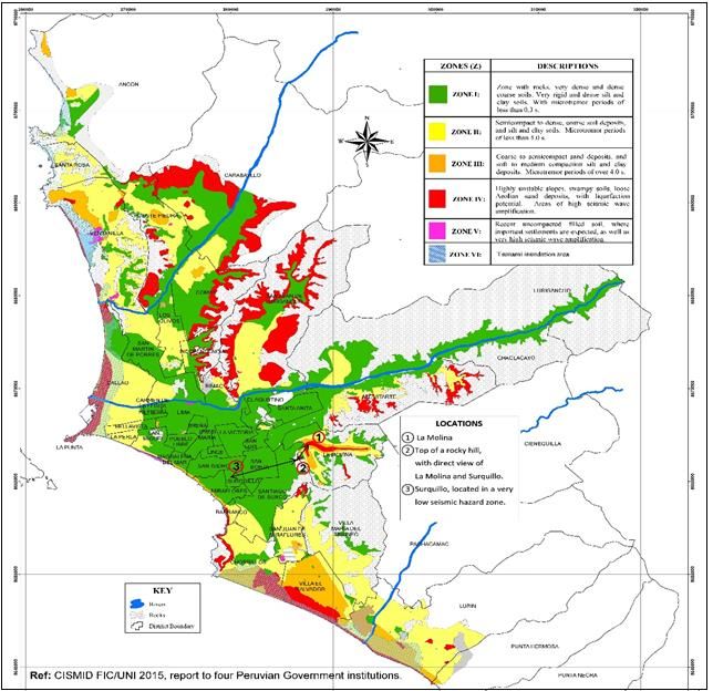
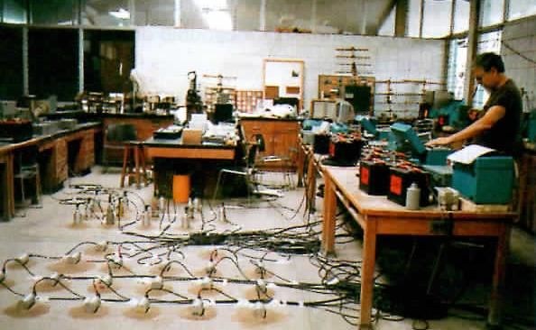
2. BACKGROUND AND PREPARATION FOR INVESTIGATING GLOBAL MICROZONATION
 EFFECTS
 Peru reached the state of the art in the development of multihazard maps (MHM), first in 1970, when the Japanese
 Scientific Mission (JSM) developed the MHM of the city of Chimbote, severely affected by the Ancash, Peru 1970
 earthquake, 7.8 Richter magnitude. The earthquake killed 67 000 persons, being the most deadly disaster in the
 Americas during the 20th century. The country objective is that it will be not repeated in the 21st century. Of these
 victims, 27 000 were buried by the avalanche of rocks, ice and mud, produced by the seismic vibrations generated
 on the north peak of Mt. Huascaran, 6 768 m. The city of Yungay and the town of Ranrahirca, were erased from the
 map forever, as well as towns located on the border, downstream of the River Santa. In 2008, the author inspected
 the damage caused by the Sichuan, China earthquake Mw 7.9, of May 12, 2008. Beichuan was a city with 180 000
 inhabitants, which was almost destroyed by the earthquake´s strong vibrations, intensity XI MMI. The total death
 toll in the Sichuan Province was 80 000 people, and 350 000 were injured. During the rainy season of September
 2008, landslides in two tributaries of the river that crosses Beichuan collapsed; the city was severely flooded, and it
 was left completely destroyed. During interviews with the local authorities and residents, they suggested that the
 city of Beichuan should remain as a full-scale museum, as an example of where not to live. Yungay and
 Ranrahirca; and Sichuan are two extreme examples that clearly show where cities should not be located.

 The state of the art in developing MHM was also reached in 1980, when the author’s consulting company was
 requested by Taylor Woodrow, one of the largest U.K. general construction corporations, to perform the site
 investigation of the location of a small experimental nuclear reactor in Huarangal, 30 km north west of Lima. The
 regulations for site studies were those published by the U.N. International Atomic Energy Agency of Vienna
 Austria.

 The main conclusions are that geological hazards –earthquakes, tsunamis, and volcanic eruptions– and
 hydrometeorological events including climate change hazards are highly dependent on natural site conditions; and
 that by applying multihazard maps to expand and densify cities and to locate buildings and infrastructures in low-
 hazard areas, we can drastically reduce disaster losses. However, hazards are still not given their due importance
 when decisions are made on where to locate important investments; this is even true in some cases in advanced
 countries.

3. SITE INVESTIGATION OF LA MOLINA EFFECTS
 The 1940 Lima earthquake effects were known by reviewing published reports, and the 1966 and 1974 Lima
 earthquakes were investigated in some detail with the assistance of graduate students of the National University of
 Engineering, who developed their civil engineering professional and Masters theses. The author’s engineering
 consulting company was involved in reviewing some retrofitting projects and reports.

 3.1. Investigation of microzonation effects of low magnitude earthquakes in the La Molina area and the
 Rimac Valley
 Brian Tucker, president of Geohazard International Menlo Park, CA, in 1983 asked the author about a location in
 Arequipa, where, during previous investigations of the Arequipa 1979 earthquake, it had been noted that damage to
 buildings located in cultivated valleys was clearly more severe than to those located on dry, compact soil along the
 valley border. It was common practice during the Inca times to build on the valley borders to preserve green areas
 and reduce the risk of disasters.

 Arequipa is located some 1 000 km south of Lima. Tucker was advised to investigate, instead, the site characteristics in
 La Molina and Lima, due to logistic facilities in the country’s capital city, the existing data available for making
 comparisons, and the common interest of the site effects. In February and March 1984, Brian recorded over a dozen
 events of about 4.0 Richter magnitude, from which he selected the records of seven events for further analysis.

 La Molina is a small narrow ravine tributary of the dejection cone of the Rimac River that crosses Lima east to
 west. See F-01. Rimac is a torrential river originating in the western Andes range at over 5 000 m.a.s.l., and Lima is
 located on the edge of the Pacific ocean, on average 100 m.a.s.l. and distant only some 120 km from the Andes
 water division line; so the soil is coarse with round stones and large sand particles, well compacted, with soil S
 waves velocity over 400 m/s, classified as very dense soil or soft rock by the International Code Council, widely
 used in the Americas. However, in La Molina its residual soil, product of the weathering of surrounding rocky hills,
 resulted in uncompacted soil. The seismic waves are also trapped in the narrow ravine by the stiff mountain rocks,
 increasing the seismic intensity.

 During February and March 1994, 15 small magnitude earthquakes of about 4 Richter were recorded, from which
 the seven with the highest magnitude were selected for analysis. Their epicentral distances were 48 to 84 km from
 La Molina. Ten seismometers were deployed, each one having three components: NS, EW and vertical, with the
 pendulum period of 1s, digital register, pass band between 0 and 30 Hz, and amplifier. Eight such seismometers
 were installed at La Molina, seven on soil in two alignments along the length and width of the small valley, and one
 on a rock outcrop. The remaining two were installed in Surquillo, representing Lima’s very low seismic hazard soil,
 and another on top of a rocky hill; this had no communication interference with the other stations, and was
 designated the master station that triggered the seismometer system with a radio link.

 3
F-01. SEISMIC HAZARD OF LIMA METROPOLITAN AREA, PERU, AND LOCATION OF
 SEISMOMETERS IN THE LA MOLINA EXPERIMENT

 Zone with rocks, very dense and dense
 ZONE I
 coarse soils. Very rigid and dense silt and
 clay soils. With microtremor periods of less
 than 0,3 s.
 Semicompact to dense, coarse soil deposits, and
 ZONE II silt and clay soils. Microtremor periods of less
 than 4.0 s.
 Coarse to semicompact sand deposits, and soft
 ZONE III to medium compaction silt and clay deposits.
 Microtremor periods of over 4.0 s.

 Highly unstable slopes, swampy soils, loose
 ZONE VI Aeolian sand deposits, with liquefaction potential.
 Areas of high seismic wave amplification.
 Recent uncompacted filled soil, where important
 ZONE V settlements are expected, as well as very high
 seismic wave amplification.

 ZONE VI Tsunami inundation area.

 Author´s Notes. The descriptions of the zones were not literally translated into English. He suggests that for
 defining seismic hazard zones, as an alternative, this be done according to Table 1613.5.2., page 341, of the
 International Building Code (IBC) version 2009 or newer. The IBC is used in the USA and most of the Latin
 American countries. At present the cost and time for measuring S-wave velocity have been substantially
 reduced. The application of ̅ in engineering practice for RRD will be direct.

The data of the analysis of La Molina experiment were sent by Tucker to the author. The analysis was the work of
Dr. Rafael Benites as part of his graduate work at the Massachusetts Institute of Technology. His advisor was Prof.
K. Aki.

The spectral ratios for the E-W and N-S components of La Molina with regard to La Molina rock and Lima Rock
for the E-W component event E are shown in F-02c and in F-02d they are shown for the N-S component of event
C. The relative difference of these ratios shows an amplification up to 8 for the E-W component of event E from
2.5-6.5 Hz and in the N-S component of event C from 2.5-6.7 or For 3HZ or T = 0.33 s the amplification is
maximum, which is close to the period of the first natural mode vibration of buildings on the UNALM campus,
which have repeatedly been damaged.

 4
F-02. LA MOLINA EXPERIMENT BY BRIAN TUCKER, 1994

a) b)

 a). Seismometers being calibrated at the Geotechnical b). Ratio of acceleration on rock and acceleration on
 Laboratory of UNALM. Those in the foreground record soft soils. (Ref. ldriss. 1991). La Molina 1984 were
 horizontal components. Those in the background record added by B. Tucker, R. Benites and the author.
 vertical movements.

 c) d)

 c) and d) spectral ratio and frequencies between La Molina Rock and Lima Rock . For frequencies of engineering
 interest 1 to 10 cps or T=0,1 to 1,0 s, the ratio varies from 3 to nearly 10, that is, from 300 to 1,000% of
 amplification. This is for small earthquakes. The amplification ratio is reduced for more intense earthquakes. See
 F-02b. Notice when the acceleration on rock approaches 0.40 g, because of the highly non–linear behavior of the
 ground, acceleration on soft soil grows very slowly, and at that level there is almost no amplification. This
 information may be useful to avoid the designing of unnecessarily robust and costly buildings.

 4. TSUNAMI THREATS IN THE AMERICAS AND JAPAN
 Lately the field surveys of the author have been reduced to a few days. After reviewing existing field reports and
 structural and nonstructural measures on RRD, interviews are conducted with key persons on previously selected
 matters of interest. For example, for the damage inspection of the Maule, Chile 2010 earthquake, only the
 Concepción water treatment plant was visited, and the influence of the site’s natural conditions on the damage
 degree, extending to the port of Dichato, some 35 km north of the city of Concepcion. Dichato is on the border of a
 “U” shaped bay, open directly to the seismic epicenter of the 2010 earthquake and it suffered severe damage. All
 wooden houses were totally destroyed, except for 1.5 m x 1.5 m brick bathrooms that remained undamaged, as seen
 in 2010 photographs. In January 2017, in the abandoned areas, those small constructions were still there. The
 5
objective of inspecting the Dichato tsunami effect was to compare what happened in Sanriku, Japan, during the
 2011 tsunami, and the previous ones of 1896 and 1933, where there are a series of V, U and W-shaped bays and the
 tsunami waves were exceptionally high. Sanriku is one of the world’s regions most sensitive to tsunami effects;
 including distant tsunamis, such as, for example, the unknown 1 700 tsunami. Recently applying paleotsunami
 techniques, it was confirmed by C14 dating that in 1700 + 10 years, a large tsunami that was generated in the Juan
 de Fuka subduction zone in the USA north western region was the origin of the tsunami that affected the Sanriku
 region in 1700.

 During the great Valdivia, Chile Mw 9.5 earthquake, a large tsunami generated by the event spread all over the
 Pacific Ocean, causing more than 100 mortal victims in the Hawaian islands, Sanriku, and other places. Crescent
 City in northern CA was affected by tsunamis originating in Alaska in 1946 and in Japan in 2011. During the
 Indian Ocean tsunami of 2004, it was one of the places on the west coast of the Americas where the tsunami waves
 were the highest, together with those recorded in Arica, Chile. On the other hand, the Port of Paracas was not
 inundated by the tsunami during the Pisco Peru 2007 earthquake and tsunami. Are there places naturally protected
 from tsunamis? Has anybody been investigating the matter? If so, please contact the author: jkuroiwa@drperu-
 international.com

 When the author, together with Dr. Li-Fan Liu Prof. Emeritus of Engineering at Cornell University, USA, was
 invited to Japan to receive the Tsunami Hamaguchi Goryo International Recognition in Tokyo on November 1st,
 2017, when preparing his lecture, he investigated the Callao Port tsunami hazard, and found that 65% of the
 country’s import and export activity uses the port of Callao, and the tsunami risk is very high. Most of Peru’s Navy
 units are placed in Callao. The author is suggesting that the Peruvian Navy verify whether Paracas really is a
 “tsunami-free port”. DHN Scientific technical unit of the Peruvian Navy has the tools and personnel trained in
 Japan to do their job. The new highway from Callao to Paracas has just been completed in two double lane
 freeways of 210 km. So the access to Pisco from Lima/Callao has been facilitated.

 In addition to reducing the earthquake and tsunami risks of the Port of Callao, it is necessary to improve the port
 underway project, according to updated scientific-technical knowledge and consultants with experience. On
 November 2, 2017, the author visited PARI –the Port and Airport Research Institute– of the Government of Japan
 located in Kawasaki, Japan, which may provide technical assistance to upgrade the tsunami resistance of the Port of
 Callao.

5. NEW THREATS FOR LARGE JAPANESE CITIES AND REDUCING LOSSES OF BUSINESS
 INVESTMENTS
 The Tohoku earthquake and tsunami was inspected, five years after the event, focusing on damage to the water and
 sewage system of the lower area of Sendai city, and a new problem emerged. It was odd to know that water pipes
 were broken in large numbers in the upper area of Sendai city, which is a hilly area where stiff soil predominates. A
 large number of water pipes were broken in the transition strip of cut and filled soils, and in the filled area near the
 transition border. Engineers from the Municipality of Sendai told the author that large Japanese cities such as
 Tokyo, Osaka and Nagoya have the same problem, previously not foreseen. In Latin America in the Armenia,
 Colombia 1999, and Tacna, Peru 2001 earthquakes, in the filled areas, when cut and fill were made for urban
 habilitation, the destruction of buildings and infrastructure was total there. They were man-created risk scenarios,
 which may be reduced if filled areas are used for parks and recreation areas in the city urban planning, and in the
 remaining areas flexible and light material constructions such as wooden houses are built.

 In the sewage treatment plant of Sendai located near the sea shore, structural damage to the four-story reinforced
 concrete building was observed, caused by the impact of 10 m tsunami waves, as well as the loss of its
 electromechanical components, caused by tsunami inundation. Now watertight doors protect the electromechanical
 equipment. The inspection was guided by the plant engineers and by members of the Sendai City Department of
 Engineering. At the Municipality of Sendai, Business Continuity Planning (BCP) and its management (BCM) for
 water and sewage systems were also discussed.
 .
 BCP and BCM consume valuable management time; in the case of the 2011 Tohoku earthquake, Mw 9.0, and
 tsunami, they proved to be very useful to RRD. Even in advanced countries, however, BCP and BCM are not
 efficiently applied in some cases, especially in small and medium businesses.

 Ban Ki-moon issued a stark warning from the UN Headquarters in New York in 2013 to the world’s business
 community that “Economic losses linked to disasters are out of control and will continue to escalate unless disaster
 risk management becomes a core part of business investment strategies,” and he continued: “We have carried out a
 thorough review of disaster losses at national level and it is clear that direct losses from floods, earthquakes and
 drought have been underestimated by at least 50%. So far this century, direct losses from disasters are in the range
 of US$ 2.5 trillion.”

 6
Losses can be reduced if we select low-hazard areas or lots to develop industrial plants, malls, storage areas,
 hospitals, and school buildings; and by developing the plot plan of the facilities, locating the more costly equipment
 and finished products in the relatively low-hazard area of the selected lot, and raw material storage and recreation
 areas in relatively higher hazard sectors. For example, if a river is the origin of the hazard, within the lot, the strip
 closest to the river should be used for the least costly investment of the area if the area is flooded for example by a
 1,000-year return period event. With such measures, it is possible to reduce material losses from 20 to 80% of the
 possible total losses, and consume a relatively short management time. The project manager, with the advice of a
 geologist, a civil engineer, and an urban planner, will be able to solve the problem efficiently.

6. PERU STATE POLITICS AND LEGAL FRAMEWORK FOR DRR
 After insisting for many years that disaster reduction needed to be one of Peru’s State Policies, (see p. 416 of the
 book Disaster Reduction, Kuroiwa J. (2005)) on December 17, 2010 in Peru’s Government Palace in Lima, a
 plenary session of the National Agreement unanimously approved that Disaster Risk Reduction would become
 Peru’s State Policy Nº 32. On November 1st, 2012, Peru’s National Government 2011-2016 by Supreme Decree Nº
 111, of the Peruvian Prime Minister’s Office, approved that State Policy Nº 32 was to be of compulsory
 compliance by all officials of the central government and regional and local government authorities. Both these
 high level decisions (of 2010 and 2012) are facilitating DRR activities and investments.

 In September 2017, the Mexico Chiappas and Puebla earthquakes alarmed Peruvian people who saw on television
 how 8 to 12-story buildings collapsed, killing and trapping people. In front of Lima there is a seismic gap clearly
 seen on the Seismic Map of Peru produced by the Peruvian Geophysical Institute (IGP), where researchers advise
 authorities and people on the imminence of a great magnitude earthquake that threatens Lima’s 10.3 million
 inhabitants, and if a tsunami is generated, a large number of people may lose their lives. The author was invited to a
 widely viewed political TV programme, on September 15, 2017. There the author proposed to the Peruvian
 Government 2016-2021: “To train Peruvians with less socioeconomic capacity and knowledge on DRR, to be able
 to confront different disaster scenarios with knowledge and readiness, by training them efficiently.” The proposal
 was made because during the 2007 Peru earthquake and tsunami, people from La Punta, Callao, a high tsunami risk
 district, the evacuation was chaotic despite the fact that the people living there are well educated people, who were
 trained during two three-year periods by a dedicated mayor, using the traditional method applied in Peru for some
 decades. But during the 2007 incident, it was proved that those people were not at the level of high school students
 in Japan, as “the Kamaishi Miracle” showed, nor at the level of the Chilean population. In Chile during the 2010
 earthquake and tsunami, even though the tsunami alarm was cancelled due to a technical misunderstanding,
 Chileans living in the tsunami inundation areas near the epicenter evacuated the hazardous area because of the clear
 interpretation of natural signs, such as the short difference of time of the arrival of P and S waves, and long
 duration of the earthquake (more than three minutes).

 A few days after the TV programme message, the author was contacted by the then Peruvian Minister of Defense,
 Dr. Carlos Nieto, who did very well during the occurrence of the Coastal El Niño 2017, putting out clear, short
 messages from the National Emergency Operation Center (COEN). After a working meeting of 75 minutes a few
 days after the TV proposal, the author was appointed ad-honorem advisor to the Minister of Defense focused on the
 El Niño 2017 reconstructions and on educating Peru’s poorer sectors in DRR knowledge. During a later meeting,
 Dr. Nieto commented that the author’s books Reducción de Desastres (2002) in Spanish and Disaster Reduction
 (2005) in English, need to be read by all officials of the Peruvian Army, Air Force, Navy and National Police.
 Accordingly, starting in mid-October 2017 these books are being up dated to 2018, to include the important global
 and local advancement. This time, the author is having the valuable collaboration of Dr. Jose Salas professor of
 Hydrology and Hydraulics from the Colorado State University at Fort Collins CO, recognized by the American
 Association of Civil Engineers; and of Prof. Manual Garcia of The National University of Colombia, Bogota, an
 expert on landslides, as proved in the field at the Paz del Rio area, when the author was the chief technical advisor
 to the Government of Colombia, UN Disaster Mitigation Programme in Colombia. The Team for updating includes
 some of the author’s former students, who are at present the best in the country in their specialties.

 But in the adaptation of Peru’s Sustainable Programme, Peru’s Civil Defense UNDP -which produced the
 multihazard maps of 175 Peruvian and four Ecuadorian Cities from 1998 to 2015- to become Peru’s Resilient
 Cities Programme (PRCP) 2017-2030 two more attributes are being added.

 Attributes being added:
 • Full incorporation of community members to PRCP 2017-2030, so that they will be trained to be responsible
 for their own safety, especially to locate their new homes in low-hazard areas. The active participation of
 sociologists and social communicators is needed, and in remote towns and rural areas primary school teachers
 and members of the National Police are essential.

 7
• Incorporation of the civil community, focusing on business men who need to protect their assets and future
 investments.

 So the new book is going to reach a wider audience and need not be so technical as the author’s past books,
 addressed to engineers, architects and other technical practicing professionals. To begin with, the first two chapters
 are completely new and a “mobile focus group” is reviewing them to receive their recommendations.

7. CONCLUSIONS AND ACKNOWLEDGMENTS
 Just as the “Miracle of Kamaishi” was not a miracle but the result of the Japanese system of good education to
 protect people’s lives from disasters, so innovations on RRD are products of the systematic planning and execution
 of long-term objectives. In the case of the Miracle of Kamaishi, a key measure was added by Dr. Katada, Prof. of
 Civil Engineering of Gunma University, who advised the educational system of the port of Kamaishi, severely
 affected by the 1896 and 1933 tsunamis, that the tsunami inundation maps of the Municipality of Kamaishi were
 useful for the past, but the tsunamis that threatened Kamaishi in the future might go beyond the limit in which the
 population of the port was trained. Katada’s innovation was that instead of telling the school teachers that a 1,000-
 year return period tsunami was threatening Kamaishi, as indeed happened, which could have caused confusion and
 discussions, he found a simple way to transmit his conclusions to the population of Kamaishi, merely telling them
 that the old inundation limit needed to be extended.

 Innovation in DRR is a product of good knowledge of the threat, as stated in the first priority action of the Sendai
 Frame for RRD 2015-2030; but to know what requires to be added to existing strategy and techniques of innovative
 approach, it is necessary to be updated.

 In the case of the author this was made possible thanks to the generosity of several individuals and institutions.
 Only a few will be mentioned here. The late emeritus Caltech professor George W. Housner, the father of
 Earthquake Engineering in the USA, mentor of the author for more than 40 years. Prof. Makoto Watabe of Tokyo
 Metropolitan University, thanks to whose continuous support, together with that of Dr. Ichiro Tanahashi and Prof.
 Roberto Morales, former rector of UNI, it was made possible to set up the Japan–Peru Center for Earthquake
 Research and Disaster Mitigation Center CISMID at the National University of Engineering Lima – Peru, with the
 invaluable support of JICA. From 1986 to date, former students of the author had institutional framework to
 develop most of the 180 professional engineering and M.Sc theses on DRR, some of them of a high enough quality
 to be international contributions. The UN agencies UNDP, UNDRO then UNDHA/Geneva, at present OCHA, the
 World Bank, the Organization of American States OAS, JICA, USNSF, USAID, UK DFID, Canadian CIDA, just
 to mention a few, made it possible to do field damage surveys for 10 days to two weeks during the early days, and
 for a few days with specific objectives, contacting key institutions and persons during the past few years.

 But private companies have also contributed to the author’s training. When the author’s consulting company was in
 charge of the supervision of the 60,000 m2 of Callao’s Port Container Terminal, it was found that the high pressure
 fire control system pipes were asbestos cement pipe fixed on reinforced concrete cylinders 1.8 m in diameter and
 2.0 m depth.

 The water pipes were located on reclaimed mud from the ocean bottom. The author proposed to the Callao Port
 Authority, the owner of the project, the designer and the constructor, to change the design of the high pressure
 water system. This proposal was accepted, and the asbestos cement pipes were replaced by ductile steel pipes; in
 addition, the fixed joints were changed for mobile pipe unions permitting longitude movement and rotation.
 During the Ica Region 2007 earthquake, the system did not suffer any damage. In early 2016 the author was visted
 by Frans Alfering, a Dutch expert on modern water pipes. He was surprised that in Peru in 1982, the mobile joints
 were used to take permanent soil deformation caused by soil liquefaction, and that this was solved with same
 technical approach as the Kubota pipes’ flexible joints, which did not suffer damage during the Tohoku, Japan
 2011 earthquake in the area where widespread liquefaction occurred. Frans Alferink recommended MEXICHEM –
 a multinational corporation that manufactures water pipes, for example PVC-O longitudinally and radially
 expanded pipes with new joints. As a social responsibility, MEXICHEM SA granted a recognition to the author,
 which was invested in producing a new Guide, Practical Manual for Disaster Reduction for Protecting water and
 sewage systems from earthquakes, tsunamis, flooding, and landslides, a 200-page book published in May 2017,
 which is being useful, since the goal of the Peru’s present government is to provide water services to all Peruvians.

 8
SELECTED REFERENCES

BRUNO A., MAS E., KOSHIMURA S., FUJII Y., YAURI S., JIMENEZ C., AND H., YANAGISAWA (2013).-
 “Tsunami Inundation Mapping in Lima, for Two Tsunami Source Scenarios”. Journal of Disaster Research (2) 274-
 284. March 2013.
CHAVEZ M., GHIL M. AND J. URRUTIA-FUCUGAUCHI. (2016). “Extreme Events. Observations, Modeling, and
 Economics”. Geophysical Monograph Series. GM 214. Co-publication of American Geophysical Union and John
 Wiley and Sons. 423 p.
DELGADO A., and C. GARCÍA. (1982). “Evacuation Plan for cities affected by tsunamis, La Punta-Pucusana area”.
 Professional Thesis. School of Civil Engineering, National University of Engineering. Lima Peru.
EERI SPECIAL EARTHQUAKE REPORT (2011). Learning from Earthquake. The Japan Tohoku Tsunami of March
 11, 2011. Nov. 2011.
GOVERNMENT OF JAPAN, GFDRR, THE WORLD BANK (2012). LEARNING FROM MEGADISASTER 2011.
 The Great East Japan Earthquake. Presented in the International Seminar of the Board of Governors of the World
 Bank held in Tokyo Japan, in October 2012.
JIMÉNEZ C., MOGGIANO N., MAS E., ADRIANO B., KOSHIMURA S., FUJII Y. and YANAGISAWA H. (2013).
 Seismic Source of 1746 Callao Earthquake from Tsunami Numerical Modeling. Journal of Disaster Research, Vol.
 8 No. 2.
KUROIWA, J. and A. DELGADO (2017). Resiliente Cities Agenda for the 21st Century. 16th World Conference on
 Earthquake, 16WCEE 2017. Santiago Chile, January 9th to 13th 2017. Available in Disaster Risk Reduction Peru
 International web page.
KUROIWA, Julio (2014). Peru sustainable (resilient) cities programme 1998-2012. Its application 2014 - 2021. 4th
 International Conference on Building Resilience, 8-11 September 2014, Salford Quays, United Kingdom.
 Available online at www.sciencedirect.com. Science Direct.
KUROIWA J. (2008). New Approach to Reducing The Risk of Natural Disasters. 14 th. World Seismic Engineering
 Conference 12 - 17 October 2008, Beijing, CHINA.
KUROIWA, Julio (2006). The Peru's Sustainable Cities Program 1998-2005 and its Application to Large Built-up
 Areas. 100th Anniversary Earthquake Conference. Commemorating the 1906 San Francisco Earthquake. San
 Francisco CA, USA.
KUROIWA J. (2005). Water Crisis, Lifelines and Urban Fires. IRCC Global Policy Summit on Sustainability Marriot
 Resort Surfers Paradise. 15 Sept. 2005. Queensland, AUSTRALIA.
KUROIWA J. (2002). Sustainable Cities, a Regional Seismic Scenario, and the 2001.06.23 Arequipa Peru Earthquake.
 Invited autor by NOAA and OAS. Special Issue of Natural Hazard Review. Reston, Virginia, USA.

MAS, Erick (2009). Reinforced concrete tsunami-resistant structures based on experiences of tsunamis in the Indian
 Ocean (2004) and Camaná (2001). Master Sc thesis, FIC / UNI.
MATTHEW FRANCIS J., Principal Advisor: YEH H. Oregon State University. FEMA & EERI (2006). Tsunami
 Inundation of Roadways, Bridges and Foundations. Observations and Technical Guidance from the Great Sumatra
 Andaman Tsunami. EERI/FEMA NEHRP 2006, Professional Fellowship Report.
MINISTERIO DE DEFENSA. MARINA DE GUERRA DEL PERÚ. Directorate of Hydrography and Navigation. Post
 Tsunami Report, August 2007.
O´ROURKI, M. J. and LIU, X. (1999). Response of Buried Pipelines Subject to Earthquake Effects. MCEER Serie
 Monographic Nº 3. Bufalo. NY, USA. 249 p.
OPS/OMS (1998). Mitigation of Natural Disasters in Drinking Water Systems and Sanitary Sewerage. Guidelines for
 Vulnerability Analysis. Disaster Mitigation Series. Washington DC, USA.
SIMONS M., MINSON S., SLADEN A., ORTEGA F., JIANG J., OWEN S., MENG L., AMPUERO .J.P, WEI S.,
 CHU R., HELMBERGER D., KANAMORI H., HETLAND E., MOORE A. and WEBB F. (2011). The 2011
 Magnitude 9.0 Tohoku-Oki Earthquake: Mosaicking the Megathrust from Seconds to Centuries. Science Vol. 332,
 17 June 2011.
THE MIRACLE OF KAMAISHI: How 3,000 students survived 3/11. Public Relations Office Government of Japan.
 http://mnj.gov-online.go.jp/kamaishi.html
UNISDR. Hyogo Framework for Action 2005-2015.
UNISDR. Sendai Framework for Disaster Risk Reduction 2015-2030.
YAMAZAKI F. and ZAVALA C. (2012). SATREPS Project on Enhancement of Earthquake and Tsunami Disaster
 Mitigation Technology in Peru. Journal of Disaster Research, Vol. 8, No. 2. 224-234.

 9
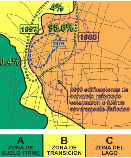
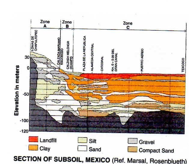
ANNEX I

 ILLUSTRATION OF SELECTED CASES OF CLEAR MICROZONATION
 EFFECTS
From the many cases of field damage surveys made by the author, a few cases have been selected where the
microzonation effects were very clear, to illustrate how important site hazards are in RRD.

Microzonation Effects of the 1985 Michoacan, Mexico, Earthquake
The 1985 Michoacan, Mexico earthquake, Mw 8.1 USGS, accelerograms were recorded at different distances from the
seismic epicenter, which was located in the subduction zone of Pacific ocean in front of and very close to the Lazaro
Cardenas Port.

F-03b shows the location map of the earthquake epicenter, practically on top of Lazaro Cardenas Port, Mexico City
(MXC) some 350 km from the seismic epicenter; and Puebla, where an accelerogram was recorded that was less severe
than the nine accelerograms recorded at MXC.

F-03a shows the accelerogram recorded at Lazaro Cardenas Port, station CDR. On the left are indicated the
acceleration scale, 50 and 100 cm/s2; and horizontally, the time in seconds.

At MXC, nine records are presented: five on firm soil (TEA to VIV stations), where the peak acceleration in all cases is
less than 45cm/s2. But in the Lake Zone four stations (SCT – TLA) clearly show that the acceleration amplitude is
larger than that of the other records.

Comparing the peak acceleration in the CDR station at Lazaro Cardenas where the peak acceleration was 12 cm/s2, with
the record in the SCT station, the peak acceleration was some 120 cm/s 2, that is, in spite of the large distance, the peak
acceleration increased 10 times.

In addition, it may be noted that the larger waves are sinusoidal near to two seconds, so it is possible to understand why
almost all the 3000 buildings that collapsed or were beyond the possibility of retrofitting were buildings 7-10 story tall.
The natural first mode period of building in MXC is much larger than in Santiago de Chile or Lima Peru, with stiff and
dry soil where in general T=0.1 n, or the period of building is estimated multiplying 0.1 x n (story number): for example
for a 10-story building 0.1 x 10 = 1s, but in MXC it is about twice as much, because long piles are used in MXC. In 7-8
story buildings with period shorter than 2.0s, the first harmonic waves deteriorated their lateral rigidity and T was
enlarged approaching 2.0s, and the next sinusoidal waves liquidated the buildings, due to resonance.

In 1982, three years before the Michoacan event, Dr. Singh investigator emeritus of communicated to the author that in
Mexico there were two seismic gaps: in Michoacan and Guerrero. The seismic gap in Michoacan was activated in 1985
and in 2012-13, there were two earthquakes in the Guerrero/Oaxaca area, and one in 2017 in Chiapas. The seismic
epicenter moved from NW to SW. The accelerograms recorded in 1985 were provided to the author by Dr. Roberto
Meli professor of UNAM, director of CENAPRED at the time.

Microzonation Effects in Mexico City during the Mexico 1957, 1979 and 1985 Earthquakes
F-04a shows the most severely affected area in MXC, during the 1957, 1979 and 1985 Mexico earthquakes. They are
concentrated at the west end of the Lake Zone, where very soft or water-saturated clay predominates. Is it the result of
“U” shaped bay effect as happened in Sanriku during the 1896, 1933 and 2011 tsunamis and at the Port of Dichato,
Chile during the 2010 tsunami, where at the tip of “U” shaped bays the tsunami waves have been very high?.

The damage distribution of the 1957 MXC earthquake is highlighted in green. Notice that of the total losses, 96.5%
was concentrated in the Lake Zone, 4% in the Transition Zone, and 0.4% in the stiff soil area. The statistical data are
clear enough to demonstrate that clear microzonation effects have occurred in Mexico City during the last three
earthquakes that affected MXC.

The worst effects of the MXC 1979 earthquake were concentrated at the west end of Lake Zone. Finally, the Lake Zone
was the area where 3 000 reinforced concrete and some steel buildings 7-10 story high collapsed. Notice that the worst
effects of some areas of the 1957 earthquake are outside the Lake Zone. This may be attributed to inaccurate data
collection of the 1957 earthquake. Notice in F-04b that landfill and soft clay soil predominate in the Lake Zone to a
depth of 40-50 m.

 10
F-03. MICROZONATION EFFECTS OF THE 1985 MICHOACAN, MEXICO, EARTHQUAKE

a) b)

 b) Location of the earthquake epicenter, overlapping
 there, Lazaro Cardenas Port, Mexico City and
 Puebla. Both figures are courtesy of Prof. Singh,
 emeritus researcher of the National Autonomous
 University of Mexico (UNAM).

a) Accelerograms recorded at Lazaro Cardenas Port, near to the seismic epicenter, Station CDR in the above Fig. and
nine recorded in Mexico City, 350 km from the epicenter, five stations TEA to VIV on firm soil, and four on soft
soil, SCT to TLA at the location of the old Texcoco lake, and the last one was recorded at Puebla.

 F-04. MICROZONATION EFFECTS IN MEXICO CITY DURING THE MEXICO 1957, 1979 AND 1985
 EARTHQUAKES
 a) b)

a). Clear microzonation effects of the Mexico 1957, b). Soil profile of the Lake, Transition, and Firm Soil Zones
1979 and 1985 earthquakes: the most severely at Mexico City.
affected areas are concentrated at the west end of the
Lake Zone. Notice the damage of the 1957 event (In
green to highlight the data): 95.6% of the damagewas
concentrated at the Lake Zone, 4% in the Transition
Zone, and only 0.4% was on the firm soil where most
of Mexico City’s residents live. Please also observe
that the 3 000 reinforced concrete and steel buildings
that collapsed in 1985 are in the Lake Zone.

 11
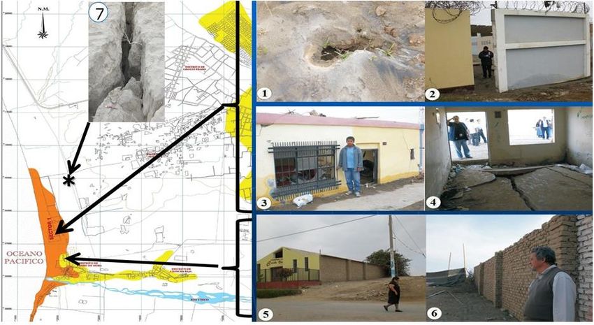
F-05. MICROZONATION EFFECTS IN TAMBO DE MORA, ICA, PERU, DURING THE PISCO 2007
 EARTHQUAKE

a)

a). Multihazard map of Tambo de Mora developed in 2001-2002 under the framework of the Sustainable City
Programme INDECI-UNDP 1998-2015. The dark orange area was qualified as high/very high hazard, and the yellow
area as low/medium hazard. 1 to 7. Effects of the 2007 earthquake in Tambo de Mora. 1) Classic “volcano” of soil
liquefaction. 2) Lateral spreading of the gray wall. 3) The brick house settled 0.70 to 0.80 m. 4) The loaded brick
walls settled, and the concrete floor was broken. 5) Adobe 4.2 m high walls of a church, and 6) Adobe 2.6 m high
wall. 5 and 6 with no damage. 7) Extensive soil liquefaction occurred north of Tambo de Mora.

 F-06. ADVANCEMENTS IN SEISMIC CODES IN PERU

a) b)

c) a) Damage due to short column structural defect. 1974
 Lima Peru earthquake.
 b) Left: building damaged by the 2007 Ica Peru
 earthquake. Right: building designed with the
 Peruvian 1997 Seismic Code. No damage.
 c) School buildings designed with the 1997 Seismic Code
 did not suffer any damage during the 2001 Arequipa or
 the 2007 Ica earthquakes in Peru

 12
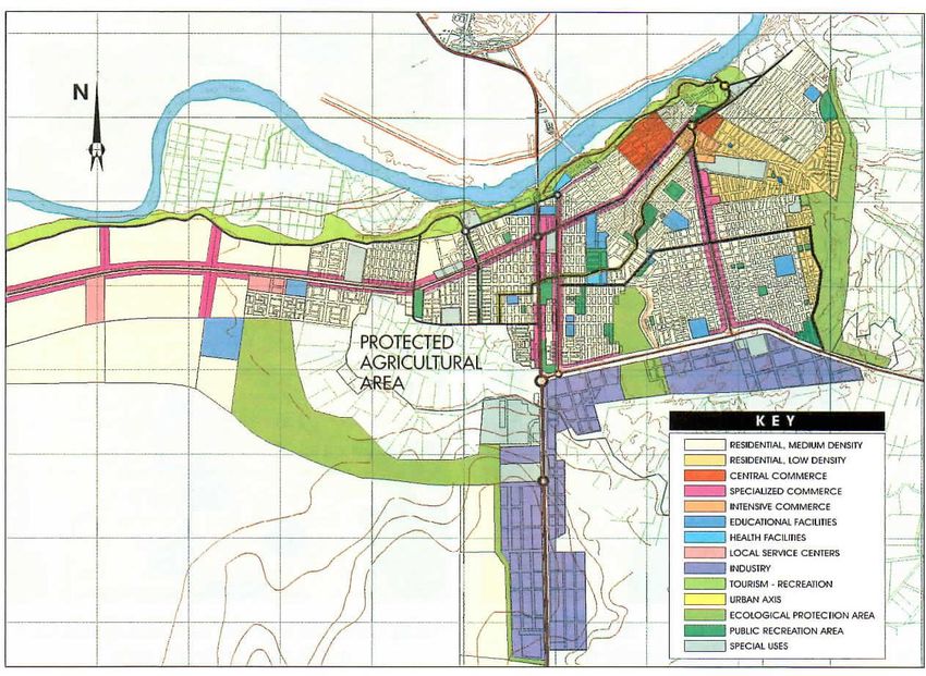
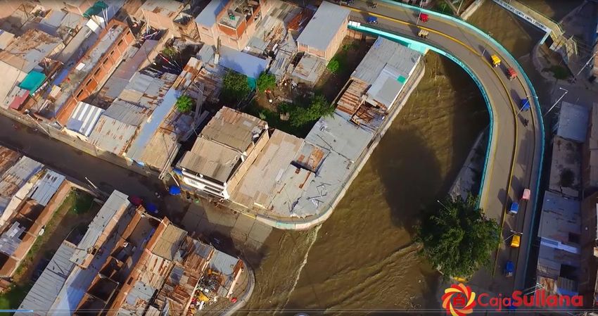
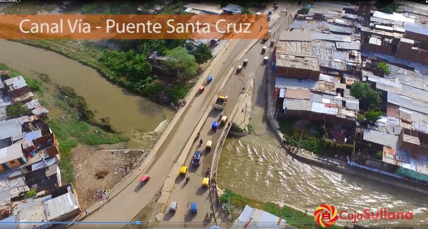
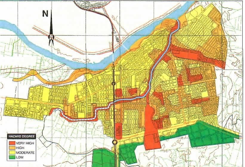
Microzonation Effect in Tambo de Mora, Ica, Peru, during the Pisco 2007 Earthquake
The microzonation effects in Tambo de Mora during the 2007 Ica Region earthquake, Mw 8.0 USGS, were investigated
noting the difference in seismic intensity in Tambo de Mora, under the framework of Peru’s Sustainable Programme
INDECI/UNDP 1998-2015, six years before the 2007 event. The microzonation map of Tambo de Mora was developed
as shown in F-05a. The dark orange area was qualified as high/high sector hazard and the yellow area low/medium
hazard. The effects of the Ica Region 2007 earthquake are shown in F-05(1) to (7), where the explanations are included
below the pictures.

Advancements in Seismic Codes in Peru
Not only in Japan and in California USA, have the seismic codes subtantially reduced structural damage, but also in
some developing countries, such as Peru. F-06a shows one of the most common structural defetcs: short columns. This
defect was common also in Japan and in the USA before the 1980s, in the Philippines during the 1990 earthquake, and
in the 1999 Chi-chi Taiwan earthquake. In the last two places and in the Nasca Peru 1996 earthquake, about 50% of the
damage in reinforced concrete school buildings was due to the structural defect of short columns.

The author was appointed chairman of the Peruvian Seismic Code 1997 Committee. He advised the Code’s working
group to increase the rigidity of buildings parallel to the main faҫade as seen in F-04a and to eliminate the short column
defect. Two professors from the Catholic University of Peru (PUCP) and the National University of Engineering (UNI),
with the assistance of a number of students who performed lengthy investigations, recommended two changes in the
1997 Peru Seismic Code: to reduce the lateral drift to 0.007; and to use symmetric faҫades including the front and back
sides, using rigid shear walls, separate 2 cm from the filling walls, and increasing the importance of building “U”
coefficient from 1.3 to 1.5. These two changes included in the 1997 seismic Code NTE 0.30/97 produce buildings such
as that present on in the right side of F-06b. F-06c shows the new school building model in Peru, which was not
damaged during the Arequipa 2001 or the Ica 2007 earthquakes.

Multihazard Map and Land-Use Plan for Sullana, Peru
F-07a shows the MHM of Sullana city located in NW Peru. During the El Niño 1982-83, the Panamerican Highway 4.0
m platform dammed a large volume of water. In March 1983 the “dam collapsed” as it was designed to take the loads
of trucks and busses. Disasters of climate origin are usually dominated by the topography of the area. When the
“dambreak” occurred, the large volume of water r through the bottom of the Quebrada, which in a cross-section is a
very open “V” shape. The damage of El Niño caused in la Quebrada is shown in F-07b and in F-07b, the canal
expressway working during El Niño 1997-98. F-07d shows the land-use plan for Sullana City developed in 2000. Due
to enlargement of the drainage area, because of an increase in urban area, the canal capacity is not enough for the larger
water volume. Engineers from the Sullana Subregion proposed to deepen the canal expressway, but this would be
complicated and costly. In 2017, a former student of the author, who developed his CE theses at UNI on local effects of
El Niño 1982-83, put forward a rational and much cheaper proposal, simple to build, sending the excess water directly
into the river as shown in the broken red line of F-07a.

Sullana Canal Expressway during the 2017 Coastal el Niño
In March 2017 during the Coastal El Niño 2017, the canal expressway was fully working and was operating at its
maximum capacity. The city of Sullana had no problem, as shown in F-08b and F-08c, whereas in Piura, the capital city
of the Grau Region, the water level in its downtown area including the main square -Plaza de Armas- was some 0.80 m
high, causing not only structural and non-structural damage, but also the total loss of contents of documents located in
basements of some government buildings.

 13
F-07. MULTIHAZARD MAP AND LAND-USE PLAN FOR SULLANA, PERU
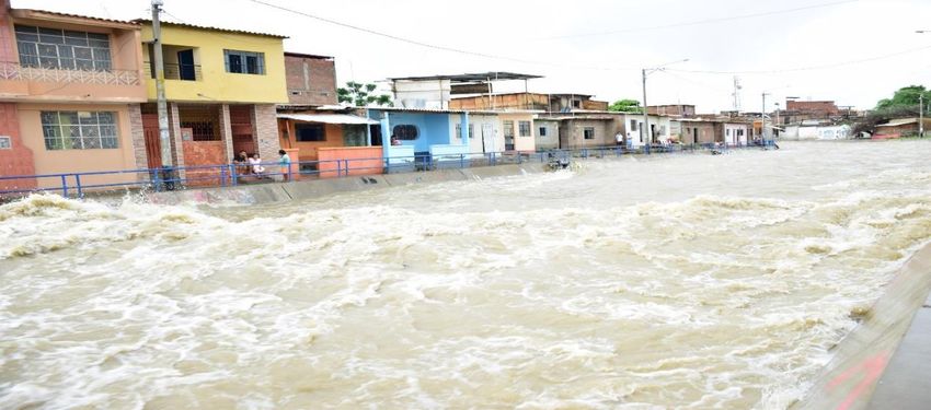
b). Damage in La Quebrada in 1983.
a). Hazard Map for Sullana, Peru. The continuous red blue strip is the canal
constructed in 1984-85, following a route traced by nature during the El
Niño in March in 1983, when a 100-300 m strip was destroyed by dammed
water overflowing because the platform of the Pan American Highway had c). The canal along la Quebrada in
broken. ("Dam break").
the 1997 – 1998 El Niño.
d). Land-use plan for Sullana, Peru, 2000. Note that a lot of agricultural land next to the city has been protected
with a green belt. The area to be developed is the desert zone to the left. During the Coastal El Niño 2017, the canal
did not have enough capacity. Local practicing civil engineers in Sullana proposed to drain the excess water with a
steel pipe (red broken line in F-05a), directly to river; this was the most rational solution, and cheaper than
deepening the canal, which would be complicated and very costly. Ref. from p. 45 of the book Disaster Reduction
Kuroiwa J. 2005 updated to 2018.
14F-08. SULLANA CANAL EXPRESSWAY DURING THE 2017 COASTAL EL NIÑO a). The Sullana Canal functioning fully in March 2017. Some doors had to be protected with sandbags and wood planks. b). Canal–via at Santa Cruz bridge. To the right, notice the vehicular entrance to the canal. c). Outside the Sullana canal-via, during the March 2017 downpour rains, vehicular transit was fluid. But in the city of Piura, the capital city of the Grau Region, its Plaza de Armas was under 0.70 m of water. b) and c) Courtesy of Caja Sullana. 15
You can also read