International Federation of ...
←
→
Page content transcription
If your browser does not render page correctly, please read the page content below
a p er
                           e d P 1
                    v i e w 202
               r R e eek
          P e e ng W
     i s a orki
This FIG e-Wlogistical
                  Applying free geotechnologies and offline maps for data collect and
                              support to Caeté S/A Sugarcane Mill, in the municipality of São
                                            Miguel dos Campos - AL

            Arthur COSTA FALCÃO TAVARES, João Pedro DOS SANTOS VERÇOSA,
        Wellington TAVARES, Ramón SALGUEIRO CRUZ and Flávio Henrique SILVA DOS
                                    SANTOS, Brazil

        Key words: geoprocessing, GIS, precision agriculture

        SUMMARY

        Applying free geotechnologies to support decision-making is becoming increasingly common,
        especially with the use of mobile devices. The objective of this work was to develop a tool
        through free geotechnologies and to create offline maps that serve as an aid to decision-making
        in the sugarcane fields. Its main focus was to verify the increase in decision-making power
        compared to the traditional methods used. The study area for application of the developed tool
        was Mill Caeté S/A, located in the municipality of São Miguel dos Campos/AL. The
        methodology was based on the acquisition of data obtained through the smartphones GPS and
        Google Earth software, to be compared to georeferenced data from rural property limits
        provided through the electronic tool (SIGEF) developed by the National Institute of
        Colonization and Agrarian Reform (INCRA). The positional accuracy value was calculated
        using the set of control and field obtained points to calculate the Standard Error (EP) values,
        and thus estimate the positioning errors (planimetry and/or altimetry) relating to the data. The
        results in Table 3 showed that data obtained by these different technologies presented different
        EP values: 5,34 m (SW MAPS); 4,71 m (MOBILE T.) and 7,50 m (GOOGLE EARTH).
        However, when verifying the adequacy of these data it was found that they fall as Class A on a
        scale of 1/50,000 and as Class B on a scale of 1/25,000. The results showed that the use of the
        tool provided a better performance for official field activities in relation to the traditional
        methods used and that the techniques do not present high precision. The implementation proved
        to be an efficient alternative to the proposed goal, making it possible to increase the decision-
        making power. However, other functionalities need to be better explored, measured and
        improved, what means these technologies need great evolutions to perform tasks that require
        high precision for sugarcane field, distance, perimeter and area measurements. Further studies
        will be necessary to quantify this information, especially when taking into account the diversity
        of smartphones available in the market today.

     Applying Free Geotechnologies and Offline Maps for Data Collect and Logistical Support to Caeté S/A Sugarcane Mill,
     in the Municipality of São Miguel Dos Campos – Al (11066)
     Arthur Costa Falcão Tavares, João Pedro Dos Santos Verçosa, Wellington Tavares dos Santos, Ramón Salgueiro Cruz,
     Flávio Henrique Dos Santos Silva (Alexandre Guimarães Duarte and Henrique Ravi Rocha De Carvalho Almeida
     (Brazil)
     FIG e-Working Week 2021
     Smart Surveyors for Land and Water Management - Challenges in a New Reality
     Virtually in the Netherlands, 21–25 June 2021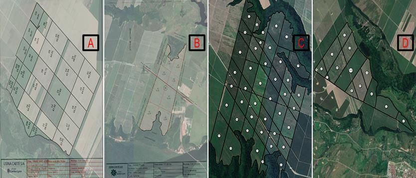
A aplicação do geoprocessamento e geotecnologias livres no suporte a tomada decisão torna-
   se cada vez mais comum, principalmente com a utilização de dispositivos móveis. O objetivo
   deste trabalho foi desenvolver uma ferramenta através da aplicabilidade de geotecnologias
   livres e da construção de mapas offline para que sirva como recurso auxiliar a tomada de decisão
   no campo canavieiro. Teve como foco principal verificar a ampliação do poder de decisão em
   comparação aos métodos tradicionais utilizados. A área de estudo para aplicação da ferramenta
   desenvolvida foi a Usina Caeté S/A, localizada no município de São Miguel dos Campos - AL.
   A metodologia foi baseada na aquisição de dados em campo através do GPS de diferentes
   modelos de smartphones e através do software Google Earth, que depois comparados com
   dados georreferenciados de limites de imóveis rurais fornecidos por ferramenta eletrônica
   (SIGEF) desenvolvida pelo Instituto Nacional de Colonização e Reforma Agrária (INCRA). A
   acurácia posicional foi calculada a partir de um conjunto de pontos de controle para obter os
   valores de Erro Padrão (EP) e com isso estimar o erro de posicionamento (planimétrico e/ou
   altimétrico) associado aos dados. Os resultados mostraram que os dados obtidos por estas
   geotecnologias livres apresentaram os seguintes valores para EP: 5,34m (SW MAPS); 4,71m
   (MOBILE T.) e 7,50m (GOOGLE EARTH). Porém, quando verificada a adequação desses
   dados (Tabela 1) foi constatado que se enquadram como Classe A para escala de 1/50.000 e
   como Classe B para escala de 1/25.000. Os resultados mostraram que o uso da ferramenta
   proporcionou um melhor desempenho das atividades em relação aos métodos tradicionais
   utilizados e que as técnicas não apresentam alta precisão. A implementação se mostrou uma
   alternativa eficiente para o fim proposto, possibilitando ampliar o poder de decisão. Porém,
   outras funcionalidades precisam ser exploradas, mensuradas e melhoradas, ou seja, essas
   geotecnologias precisam evoluir para que sejam utilizadas em tarefas do setor sucroalcooleiro
   que exijam alta precisão de medidas de localização, distância e área. Assim, serão necessários
   mais estudos para uma melhor quantificação dessas informações, principalmente quando se
   leva em conta a diversidade de modelos de smartphones disponíveis no mercado atualmente.

Applying Free Geotechnologies and Offline Maps for Data Collect and Logistical Support to Caeté S/A Sugarcane Mill,
in the Municipality of São Miguel Dos Campos – Al (11066)
Arthur Costa Falcão Tavares, João Pedro Dos Santos Verçosa, Wellington Tavares dos Santos, Ramón Salgueiro Cruz,
Flávio Henrique Dos Santos Silva (Alexandre Guimarães Duarte and Henrique Ravi Rocha De Carvalho Almeida
(Brazil)
FIG e-Working Week 2021
Smart Surveyors for Land and Water Management - Challenges in a New Reality
Virtually in the Netherlands, 21–25 June 2021

Applying free geotechnologies and offline maps for data collect and
     logistical support to Caeté S/A Sugarcane Mill, in the municipality of São
                              Miguel dos Campos - AL

       Arthur COSTA FALCÃO TAVARES, João Pedro DOS SANTOS VERÇOSA,
   Wellington TAVARES, Ramón SALGUEIRO CRUZ and Flávio Henrique SILVA DOS
                               SANTOS, Brazil

       1. INTRODUCTION

   It is common for the human being to be inserted in situations in which it is necessary to make
   a decision. Most of the time such decisions are trivial, therefore they require little reflection and
   time. However, when the resulting consequences are crucial and there is not enough information
   or analytical capability to offer a set of alternatives capable of leading to a certainty about what
   should be done, then there is a decision problem.
   Deciding on situations of uncertainties that involve high risks requires reflection on possible
   alternatives of action and on their potential consequences (CONTINI; et al., 1984). Also,
   technological advances, mainly with the availability of computers, brought the possibility of
   analyzing numerous alternatives, promoting a broadening of the horizon of possibilities of
   analysis and conferring decision-making power more efficiently, especially when combined
   with geoprocessing (ABDEL‐RAHMAN and AHMED, 2008; BOLFE, 2019; MOLIN and
   VEIGA, 2016; TAUFIK et al., 2020; ZANARDO et al., 2016).
   The current dynamic in the agricultural system carries with it the need for decision-making
   efficiently through reflection on several variables, thus requiring technological resources that
   can assist in planning, management, and decision-making from the analysis of as much
   available information as possible. In addition, when information is organized and properly
   analyzed they lead to an optimal set of alternatives for decision-making (MASSRUHÁ, 2018).
   In this sense, the emergence of equipment that allows great mobility, such as smartphones,
   together with interoperability, has allowed the achievement of a powerful resource for access
   and sharing of information when working together with geotechnologies, conferring greater
   power of analysis and decision in the field (AYAZ et al., 2019; MITTAL and TRIPATHI, 2009;
   PIVOTO et al., 2018; QIANG et al., 2011; ROSALEN et al., 2019; SAIZ-RUBIO and
   ROVIRA-MÁS, 2020; SANCHES et al., 2019). However, one of the major challenges faced in
   the use of these technologies is still the issue of internet connectivity of cell phones. The
   availability of internet access for the functioning of these tools and instruments of innovation
   is essential.
   Is the possible lack of internet connectivity a factor preventing the application of these tools
   and instruments of innovation?
   Therefore, there is the challenge of finding ways to use these technologies in order to
   circumvent this problem.

Applying Free Geotechnologies and Offline Maps for Data Collect and Logistical Support to Caeté S/A Sugarcane Mill,
in the Municipality of São Miguel Dos Campos – Al (11066)
Arthur Costa Falcão Tavares, João Pedro Dos Santos Verçosa, Wellington Tavares dos Santos, Ramón Salgueiro Cruz,
Flávio Henrique Dos Santos Silva (Alexandre Guimarães Duarte and Henrique Ravi Rocha De Carvalho Almeida
(Brazil)
FIG e-Working Week 2021
Smart Surveyors for Land and Water Management - Challenges in a New Reality
Virtually in the Netherlands, 21–25 June 2021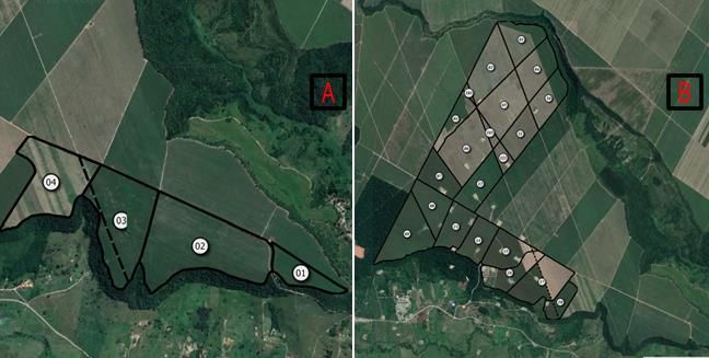
Thus, this work evaluated the applicability of free geotechnologies and offline maps through
the development of a tool that serves as a resource for data collection and support to sugarcane
logistics of Mill Caeté S/A, located in the municipality of São Miguel dos Campos/AL.
2. METHODOLOGY AND MATERIALS
2.1 Study area
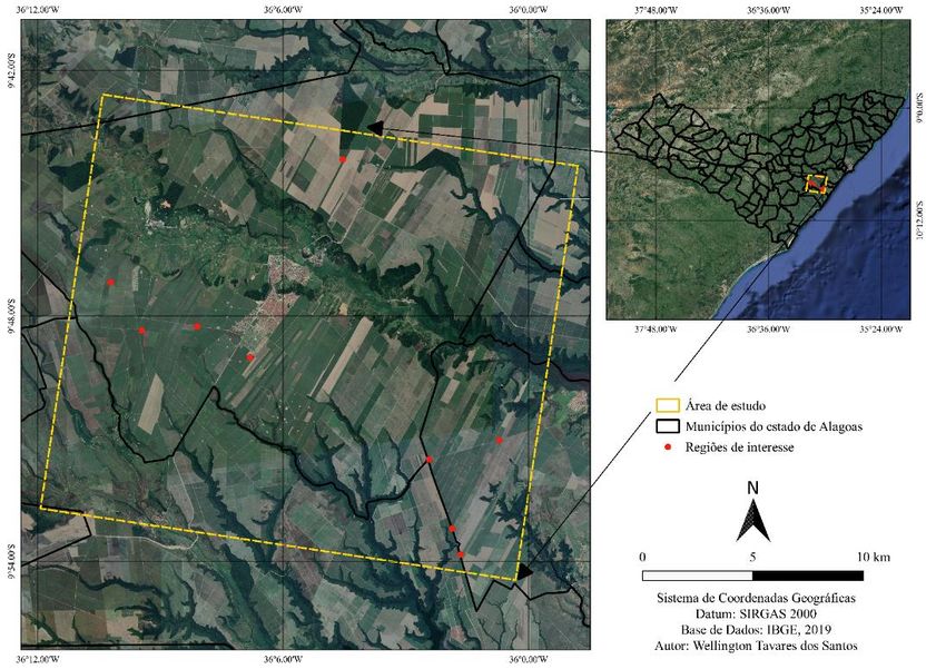
The study area map is presented below (Figure 1).
Figure 1 – Map of the Study area
Study area
Municipalities of Alagoas State
Regions of interest
Geographical Coordinate System
Datum: SIRGAS 2000
Data Base: IBGE, 2019
Source: Authors (2020)
Mill Caeté S/A, located in the municipality of São Miguel dos Campos, Alagoas State, was the
first industrial unit acquired by the Carlos Lyra Group in 1965. Investing in the most advanced
production techniques, in its activities of production of sugar, ethanol and other derivatives of
sugarcane, the Carlos Lyra Group made the Matrix a model plant. The sugarcane plantation of
Usina Caeté S/A has among its advanced production technologies mechanized harvesting, with
transshipment stations, linear irrigation systems, fertigation with vinasse /truck, since 1993, in
addition to a soil management system, with careful use of fertilizers (GRUPO CARLOS LYRA,
2020).
São Miguel dos Campos is situated between coordinates 09º 40' 24.6' and 09º 52' 58.8' latitude
S and 35º 59' 14.6' and 36º 14' 58.08' longitude O, in the southeast region of the State of Alagoas,
inserted in the mesoregion of Eastern Alagoas and in the microregion constituted by the
Applying Free Geotechnologies and Offline Maps for Data Collect and Logistical Support to Caeté S/A Sugarcane Mill,
in the Municipality of São Miguel Dos Campos – Al (11066)
Arthur Costa Falcão Tavares, João Pedro Dos Santos Verçosa, Wellington Tavares dos Santos, Ramón Salgueiro Cruz,
Flávio Henrique Dos Santos Silva (Alexandre Guimarães Duarte and Henrique Ravi Rocha De Carvalho Almeida
(Brazil)
FIG e-Working Week 2021
Smart Surveyors for Land and Water Management - Challenges in a New Reality
Virtually in the Netherlands, 21–25 June 2021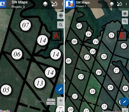
municipalities of Anadia, Campo Alegre, Junqueiro, Teotônio Vilela, Coruripe, Jequiá da Praia,
   Roteiro and Boca da Mata, whose name is microregion of São Miguel dos Campos. Its area is
   335,683 km² and its estimated population is 61,251 people (IBGE, 2019).
   Access to the municipality is possible through paved highways: BR-101, AL-105, AL-215, AL-
   220, AL-415, AL-420 and AL-450, with a route of around 74.3 km to the state capital taking
   as access to BR-101 (ONTL, 2018).

       2.2 Material Resources

   For the development of this tool, the following materials were used:
   •Mobile Topographer FREE application;
   •QGIS for Desktop data processing software, versions 2.18.28 and 3.10.8 long -lasting;
   •QuickMapService plugins, QTiles, qgis2web;
   •SW Maps application;
   •Google Earth for satellite image visualization;
   •Acer Intel® Core ™ i3 CPU M380 @2.53 GHz computer, 06 GB memory and 1 TB
   storage;
   •Galaxy J2 Prime smartphone with Android 6.0.1, 1.5 GB memory and 16 GB storage;
   •Xiaomi Redmi Note 7 smartphone with Android 10, 04 GB memory and 64 GB storage;
   •Maps of Mill Caeté S/A in PDF file.

       2.3 Methodological Procedures

   The methodological flowchart is presented on Figure 2.
                             Figure 2 – Methodological flowchart
                                                                                Vectorization,
                                                                                  Topological
                  Areas delimitation             Georreferencing
                                                                                Correction and
                                                                              Attributes Insertion

                 Creating files usable
                                                                             Creating an interactive
                   on smartphone                Importing files into
                                                                              query and geospatial
                   without internet               SW Maps app
                                                                                    platform
                     connection

                   Implementation
                                                      Results                     Conclusions
                      analysis

                                            Source: Authors (2020)
Applying Free Geotechnologies and Offline Maps for Data Collect and Logistical Support to Caeté S/A Sugarcane Mill,
in the Municipality of São Miguel Dos Campos – Al (11066)
Arthur Costa Falcão Tavares, João Pedro Dos Santos Verçosa, Wellington Tavares dos Santos, Ramón Salgueiro Cruz,
Flávio Henrique Dos Santos Silva (Alexandre Guimarães Duarte and Henrique Ravi Rocha De Carvalho Almeida
(Brazil)
FIG e-Working Week 2021
Smart Surveyors for Land and Water Management - Challenges in a New Reality
Virtually in the Netherlands, 21–25 June 2021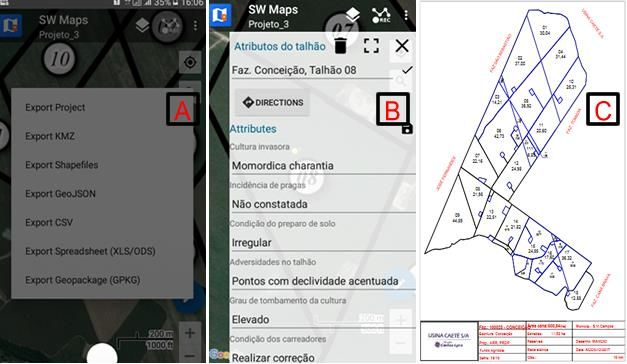
Area delimitation: Through a field visit, in each of the areas of interest some points were
   collected through the Application Mobile Topographer FREE. Subsequently, lists were
   generated with the coordinates of these points in the TXT file format and exported from the
   smartphone to the computer. These lists were used as support in the georeferencing process.
   Georeferencing: Through the lists generated in the delimitation process of the areas, the
   georeferencing of the maps made available in the version was performed. This procedure was
   performed in the long-running QGIS version 3.10.8 software. Once in possession of the lists,
   the maps in PDF file format were imported into the QGIS software. For georeferencing within
   this software, the 'Georeferrer' tool was used in the 'Raster' tab. The results generated the
   georeferenced files, which were exported in the TIF file format. It is important to note that this
   procedure differs from the georeferencing of rural properties, with a high positional accuracy
   required.
   Vectorization, topological correction and attributes insertion: Georeferenced vector maps were
   developed in the shapefile format from georeferenced files and supported by the
   QuickMapServices plugin. The topological correction was made through the tool 'check the
   validity', in the item 'Geometries', in the 'Vector' tab of the QGIS software. Subsequently, the
   attribute 'farm number, field number and area referring to each field that composes it' was added
   to each farm's shapefile.
   Creating files usable on smartphone without internet connection: Once the areas have been
   properly vectorized, georeferenced and with all desirable attributes inserted, the 'QTILES'
   plugin available in the 'Complements' tab generated the files for offline use on smartphone.
   Importing files into SW Maps app: After developing interest areas files for offline use, they
   were imported to the smartphone and later to the SW Maps app.
   Creating an interactive query and geospatial platform: It was used qgis2web, a QGIS tool, to
   visualize the shapefiles generated in the previous procedures as add-on available on the 'WEB'
   tab. An interactive web map was produced so that both the smartphone and the computer were
   able to access the data produced.
   Implementation analysis: The tool analysis was based on field monitoring for a period of time
   considering the sugarcane harvest 2019/2020 to evaluate its performance obtained by
   comparing to the traditional methods used until then. The accuracy of the smartphone's
   geographic location device was also verified, in relation to the georeferenced information of
   rural, public and private property limits, provided by the electronic platform of the Land
   Management System (SIGEF) developed by the National Institute of Colonization and Agrarian
   Reform (INCRA) to subsidize the land governance of the national territory.

       3. RESULTS AND DISCUSSION

   As result of the data geoprocessing carried out in the QGIS software, all the shapefile maps, for
   each of the selected farms, were selected being ready for offline use by the SW Maps app, in
   the smartphone (Figure 3).
   These same shapefiles were also used to develop an interactive system of geospatial
   consultation aimed at computer use, thus creating a common visual reference for all sugar cane
Applying Free Geotechnologies and Offline Maps for Data Collect and Logistical Support to Caeté S/A Sugarcane Mill,
in the Municipality of São Miguel Dos Campos – Al (11066)
Arthur Costa Falcão Tavares, João Pedro Dos Santos Verçosa, Wellington Tavares dos Santos, Ramón Salgueiro Cruz,
Flávio Henrique Dos Santos Silva (Alexandre Guimarães Duarte and Henrique Ravi Rocha De Carvalho Almeida
(Brazil)
FIG e-Working Week 2021
Smart Surveyors for Land and Water Management - Challenges in a New Reality
Virtually in the Netherlands, 21–25 June 2021
farms on different platforms (smartphone/computer) and without the need to connect to the
Internet.
To check the tool performance and usability on different platforms, two smartphones of
different models and with different versions of the Android operating system were used in the
tests. The different cell phone models showed a slight change in the size of the visual
components, in the labels of the areas and in the degree of smoothing of the geometries,
however, the tool functionality was maintained.
The changes described above may be related to Android operating system version or the screen
size configuration inherent to each of the devices used (Figure 4).
Figure 3 – Maps loaded in the SW Maps app: (A), Tomada Farm (B), Conceição Farm (B)
and Riachão Farm (D)
A B C D
Source: Authors (2020)
Figure 4 – Utinga Farm map visualized on Galaxy J2 Prime (A) and Redmi Note 7 (B)
A B
Source: Authors (2020)
In addition, divergences were found between the values of the areas and distances measured by
the device's GPS in relation to the actual values reported on the farm maps in PDF file format
that were made available by the Mill Caeté S/A.
Applying Free Geotechnologies and Offline Maps for Data Collect and Logistical Support to Caeté S/A Sugarcane Mill,
in the Municipality of São Miguel Dos Campos – Al (11066)
Arthur Costa Falcão Tavares, João Pedro Dos Santos Verçosa, Wellington Tavares dos Santos, Ramón Salgueiro Cruz,
Flávio Henrique Dos Santos Silva (Alexandre Guimarães Duarte and Henrique Ravi Rocha De Carvalho Almeida
(Brazil)
FIG e-Working Week 2021
Smart Surveyors for Land and Water Management - Challenges in a New Reality
Virtually in the Netherlands, 21–25 June 2021It was already expected because it is necessary to be cautious about the use of applications on
mobile devices that offer the possibility of working with GPS, since the values related to the
calculation of the area and distance do not have very high accuracy in Alagoas state (SILVA
and FELIPE, 2018). However, the use of this system for the prior recognition of the area is
acceptable, as long as it is kept in mind that the results obtained in this way will not come very
close to the real value.
Regard to navigation aspect and considering that the dimensions of the plots in each farm are
sufficiently large, the tool satisfactorily fulfilled the purpose, since the degree of precision and
the accuracy offered by it leads to an acceptable error (SILVA and FELIPE, 2018). However,
one must take into account the limitations of the accuracy of the GPS system (05-15 m) for civil
use (EMBRAPA TERRITORIAL, 2020; MARTINS; et al., 2017).
Systematizing this information increased the power of making decision and provided to reduce
the time wasted by errors of location when compared to the map model traditional format used
by the company in PDF file format, by associating a new perspective on the wide view of the
field with a better understanding with respect to the position in space (Figure 5).
Figure 5 – SW Maps export file formats (A), Collected attributes (B) and Map of Conceição
farm in PDF file format (C)
A B C
Source: Authors (2020)
In turn, the interactive platform for geospatial query offers the possibility of improving
interaction between the user during field work and the user in the office. The possibility of an
intercommunication via for the same visual data source, the mobile device and the interactive
platform, allows minimizing errors resulting from the misunderstanding caused by verbal
communication. This understanding expansion about spatializing information maximized
several tasks. Data images from interactive platform are shown in Figures 6, 7 and 8.
Applying Free Geotechnologies and Offline Maps for Data Collect and Logistical Support to Caeté S/A Sugarcane Mill,
in the Municipality of São Miguel Dos Campos – Al (11066)
Arthur Costa Falcão Tavares, João Pedro Dos Santos Verçosa, Wellington Tavares dos Santos, Ramón Salgueiro Cruz,
Flávio Henrique Dos Santos Silva (Alexandre Guimarães Duarte and Henrique Ravi Rocha De Carvalho Almeida
(Brazil)
FIG e-Working Week 2021
Smart Surveyors for Land and Water Management - Challenges in a New Reality
Virtually in the Netherlands, 21–25 June 2021Figure 6 – List of georeferenced areas
Source: Authors (2020)
Figure 7 – Farms São José (A), Plateia (B), Utinga (C) and Tomada (D)
A B C D
Source: Authors (2020)
Figure 8 – Farms Cana Brava (A) and Conceição (B)
A B
Source: Authors (2020)
Applying Free Geotechnologies and Offline Maps for Data Collect and Logistical Support to Caeté S/A Sugarcane Mill,
in the Municipality of São Miguel Dos Campos – Al (11066)
Arthur Costa Falcão Tavares, João Pedro Dos Santos Verçosa, Wellington Tavares dos Santos, Ramón Salgueiro Cruz,
Flávio Henrique Dos Santos Silva (Alexandre Guimarães Duarte and Henrique Ravi Rocha De Carvalho Almeida
(Brazil)
FIG e-Working Week 2021
Smart Surveyors for Land and Water Management - Challenges in a New Reality
Virtually in the Netherlands, 21–25 June 2021The positional accuracy value was calculated using the set of control (reference) and field
observed points to obtain the Standard Error (EP) values, and thus estimate the positioning
errors (planimetry and/or altimetry) relating to the data (SAMPAIO and BRANDALIZE, 2018).
More specifically, the values of the Root Mean Square Error (RMSE) were used in this work,
as it is more used by international standards to estimate positional accuracy (Figure 9).
Figure 9 – RMSEr calculation
Tested points (t) Reference Points (r) RMSEx RMSEy
2
Coord. Xt Coord. Yt Coord. Xr Coord. Yr (Xt - Xr) (Yt - Yr) 2
Point 1 Xt1 Yt1 Xr1 Yr1 (Xt1 - Xr1) 2 (Yt1 - Yr1)2
Point... ... ... ... ... ... ...
Point n Xtn Ytn Xrn Yrn (Xtn - Xrn) 2 (Ytn - Yrn)2
RMSEx √(∑/n) √(∑/n) RMSEy
RMSEr = √((RMSEx)2+((RMSEy)2)
Source: Sampaio and Brandalize (2018)
Depending on the observed accuracy patterns, the methodology used to calculate the RMSE
allows that cartographic products be inserted in different classes of EP values (Table 1).
Table 1 – Classes for cartographic products insertion
Source: Google (2020)
In order to check the adequacy of obtained data by the smartphones GPS and Google Earth, the
standard error was calculated according to the procedure shown in Figure 9. The precision
parameter considered was the database of certified rural properties made available by the Land
Management System (SIGEF).
The points collected for the comparison of the coordinates (UTM, Datum SIRGAS2000) and
the results of the analysis are presented in Tables 1, 2 and 3.
The results in Table 3 showed that data obtained by these different technologies presented
different EP values: 5,34 m (SW MAPS); 4,71 m (MOBILE T.) and 7,50 m (GOOGLE
EARTH). However, when verifying the adequacy of these data (Table 1) it was found that they
fall as Class A for a scale of 1/50,000 and as Class B for a scale of 1/25,000.
Applying Free Geotechnologies and Offline Maps for Data Collect and Logistical Support to Caeté S/A Sugarcane Mill,
in the Municipality of São Miguel Dos Campos – Al (11066)
Arthur Costa Falcão Tavares, João Pedro Dos Santos Verçosa, Wellington Tavares dos Santos, Ramón Salgueiro Cruz,
Flávio Henrique Dos Santos Silva (Alexandre Guimarães Duarte and Henrique Ravi Rocha De Carvalho Almeida
(Brazil)
FIG e-Working Week 2021
Smart Surveyors for Land and Water Management - Challenges in a New Reality
Virtually in the Netherlands, 21–25 June 2021These results differ both from those obtained by Pereira (2015), who observed usability with
security of images provided by Google Earth for a scale of 1/30,000 or lower, and accuracy
information of 4.9 m for GPS-enabled smartphones in no cloud conditions (GPS.GOV, 2020).
Table 2 – Coordinates of points collected for testing
SW MAPS MOBILE T. GOOGLE EARTH
POINT X Y X Y X Y
1 810449,04 8916918,75 810448,01 8916918,81 810451,05 8916916,56
2 811819,24 8914740,00 811818,33 8914739,94 811824,61 8914743,55
3 814302,03 8914898,62 814301,61 8914898,30 814299,57 8914902,80
4 816652,93 8913478,13 816652,32 8913477,84 816653,09 8913478,92
5 824625,14 8908819,31 824624,55 8908818,86 824615,86 8908812,20
6 825622,61 8905679,49 825622,08 8905679,15 825611,59 8905681,01
7 825997,66 8904504,56 825997,30 8904503,87 825993,11 8904505,89
8 827767,89 8909654,04 827767,51 8909653,99 827762,66 8909662,61
9 820882,20 8922373,46 820881,57 8922373,00 820882,58 8922376,14
Source: Authors (2020)
Table 3 – Coordinates of points collected as a precision parameter
SIGEF
POINT X Y
1 810444,05 8916916,56
2 811814,42 8914737,25
3 814297,41 8914896,14
4 816648,24 8913475,39
5 824619,97 8908817,86
6 825617,29 8905679,15
7 825992,54 8904504,09
8 827762,93 8909653,01
9 820876,92 8922372,03
Source: Authors (2020)
Table 4 – EP values (m) checked from the collected points
SW MAPS MOBILE T. GOOGLE EARTH
EP (m) 5,34 4,71 7,50
Source: Authors (2020)
4. CONCLUSION
This work showed that application of free geotechnologies for constructing a solution to
sugarcane sector made available functional tools to attend offline activities like data collection,
manipulation, storage, export and sharing.
The SW Maps app possibility to collect data and share georeferenced files using the device's
GPS in different formats allowed obtaining important data during field works for future
attributes insertion as plots of each farm. Combining this functionality with the generated vector
Applying Free Geotechnologies and Offline Maps for Data Collect and Logistical Support to Caeté S/A Sugarcane Mill,
in the Municipality of São Miguel Dos Campos – Al (11066)
Arthur Costa Falcão Tavares, João Pedro Dos Santos Verçosa, Wellington Tavares dos Santos, Ramón Salgueiro Cruz,
Flávio Henrique Dos Santos Silva (Alexandre Guimarães Duarte and Henrique Ravi Rocha De Carvalho Almeida
(Brazil)
FIG e-Working Week 2021
Smart Surveyors for Land and Water Management - Challenges in a New Reality
Virtually in the Netherlands, 21–25 June 2021maps made it possible to acquire data for future analyzes, promoting generated products share
and optimization of various tasks related to the production system.
Thus, it is an excellent alternative to optimize certain day-to-day work tasks that do not require
a high degree of accuracy, for faster and more assertive decision-making.
However, other functionalities need to be better explored, measured and improved, which
means these technologies need great evolution to perform tasks that require high precision for
sugarcane field, distance, perimeter and area measurements.
Further, studies will be necessary to quantify this information, especially when taking into
account the diversity of smartphones available in the market today.
5. REFERENCES
ABDEL‐RAHMAN, E. M.; AHMED, F. B. The application of remote sensing techniques to
sugarcane (Saccharum spp. hybrid) production: a review of the literature. International Journal
Of Remote Sensing, [S.L.], v. 29, n. 13, p. 3753-3767, 14 jun. 2008. Informa UK Limited.
http://dx.doi.org/10.1080/01431160701874603.
AYAZ, Muhammad; AMMAD-UDDIN, Mohammad; SHARIF, Zubair; MANSOUR, Ali;
AGGOUNE, El-Hadi M.. Internet-of-Things (IoT)-Based Smart Agriculture: toward making
the fields talk. Ieee Access, [S.L.], v. 7, p. 129551-129583, 2019. Institute of Electrical and
Electronics Engineers (IEEE). http://dx.doi.org/10.1109/access.2019.2932609.
BOLFE, Édson Luis. Application of Geotechnologies in the Development of Sustainable
Agriculture in Brazil. International Journal Of Advanced Engineering Research And Science,
[S.L.], v. 6, n. 12, p. 458-463, 2019. AI Publications. http://dx.doi.org/10.22161/ijaers.612.53.
EMBRAPA TERRITORIAL. Satélites de Monitoramento. Embrapa. 2018. Disponível em: <
https://www.embrapa.br/satelites-de-monitoramento/missoes/gps >. Acesso em: 01 out. 2020.
GPS.GOV. Precisão GPS. Space-Based Positioning Navigation & Timing. 2020. Disponível
em: . Acesso em: 21 out. 2020.
GRUPO CARLOS LYRA. Usina Caeté S/A, 2020. Disponível em:
. Acesso em: 18 ago. 2020.
IBGE. Organização do território, 2019. Disponível em:
. Acesso em: 20 ago. 2020.
MARTINS, R. N. et al. Análise da precisão de diferentes receptores GNSS para coleta de dados.
In: ENCONTRO LATINO AMERICANO DE INICIAÇÃO CIENTÍFICA, 21.; ENCONTRO
LATINO AMERICANO DE PÓS-GRADUAÇÃO, 17.; ENCONTRO DE INICIAÇÃO À
DOCÊNCIA, 7., 2017, Caçapava. Anais [...]. Caçapava, 26-27 out. 2017. Disponível em:
. Acesso
em: 20 nov. 2020.
MITTAL, Surabhi; TRIPATHI, Gaurav. Role of Mobile Phone Technology in Improving Small
Farm Productivity,Agricultural Economics Research Review, Agricultural Economics
Research Association (India), vol. 22(Conferenc), 2009.
MOLIN, José Paulo; VEIGA, João Paulo Soto. Spatial variability of sugarcane row gaps:
measurement and mapping. Ciência e Agrotecnologia, [S.L.], v. 40, n. 3, p. 347-355, jun. 2016.
FapUNIFESP (SciELO). http://dx.doi.org/10.1590/1413-70542016403046915.
Applying Free Geotechnologies and Offline Maps for Data Collect and Logistical Support to Caeté S/A Sugarcane Mill,
in the Municipality of São Miguel Dos Campos – Al (11066)
Arthur Costa Falcão Tavares, João Pedro Dos Santos Verçosa, Wellington Tavares dos Santos, Ramón Salgueiro Cruz,
Flávio Henrique Dos Santos Silva (Alexandre Guimarães Duarte and Henrique Ravi Rocha De Carvalho Almeida
(Brazil)
FIG e-Working Week 2021
Smart Surveyors for Land and Water Management - Challenges in a New Reality
Virtually in the Netherlands, 21–25 June 2021PEREIRA, L. D. S. Utilização de ferramentas e serviços google para o desenvolvimento de projetos de engenharia, arquitetura e urbanismo, 2015. Disponível em: . Acesso em: 21 out. 2020. PIVOTO, Dieisson; WAQUIL, Paulo Dabdab; TALAMINI, Edson; FINOCCHIO, Caroline Pauletto Spanhol; CORTE, Vitor Francisco dalla; MORES, Giana de Vargas. Scientific development of smart farming technologies and their application in Brazil. Information Processing In Agriculture, [S.L.], v. 5, n. 1, p. 21-32, mar. 2018. Elsevier BV. http://dx.doi.org/10.1016/j.inpa.2017.12.002. Qiang, C. Z., Kuek, S. C., Dymond, A., & Esselaar, S., (2011). “Mobile Applications for Agricultural and Rural Development”, ICT Sector Unit, World Bank http://siteresources.worldbank.org/INFORMATIONANDCOMMUNICATIONANDTECHN OLOGIES/Resources/MobileApplications_for_ARD.pdf (Accessed: 04/01/2021) ROSALEN, David; SILVA, Gustavo; COVRE, Renan; MORAIS, Lilia. SIAGRO 2019 SIMPÓSIO NACIONAL DE INSTRUMENTAÇÃO AGROPECUÁRIA, 2019, São Carlos. USO DE SMARTPHONES, APLICATIVOS E CORREÇÃO VIA INTERNET EM TEMPO REAL. São Carlos: Embrapa, 2019. 5 p. SAIZ-RUBIO, Verónica; ROVIRA-MÁS, Francisco. From Smart Farming towards Agriculture 5.0: a review on crop data management. Agronomy, [S.L.], v. 10, n. 2, p. 1-21, 3 fev. 2020. MDPI AG. http://dx.doi.org/10.3390/agronomy10020207. SAMPAIO, T. V. M.; BRANDALIZE, M. C. B. Cartografia geral, digital e temática. Curitiba, PR: Universidade Federal do Paraná, Programa de Pós-Graduação em Ciências Geodésicas, v. 1, 2018. SANCHES, Guilherme Martineli; PAULA, Maria Thereza Nonato de; MAGALHÃES, Paulo Sérgio Graziano; DUFT, Daniel Garbellini; VITTI, André César; KOLLN, Oriel Tiago; BORGES, Bernardo Melo Montes Nogueira; FRANCO, Henrique Coutinho Junqueira. Precision production environments for sugarcane fields. Scientia Agricola, [S.L.], v. 76, n. 1, p. 10-17, fev. 2019. FapUNIFESP (SciELO). http://dx.doi.org/10.1590/1678-992x-2017-0128 SILVA, C. G. C.; FELIPE, A. L. D. S. Comparação de aplicativos GNSS em cálculos de distância. Revista Científica Eletrônica de Agronomia da FAEF, SP, v. 34, n. 1, p. 27-28, dez. 2018. TAUFIK, Muhammad; AMILUDDIN, Afif; BIORESITA, Filsa. Generated Topographic Data from UAV, For Simple Irrigation Planning (Case Study, Sugar Cane in Jember). International Research Journal Of Advanced Engineering And Science, [s. l], v. 5, n. 1, p. 245-248, 2020. ZANARDO, Fábio H.; RODRIGUES, Ricardo A. F.; SILVA, Helio R.; MARQUES, Artur P.; FARIA, Glaucia A. Geotechnology application for data acquisition for agricultural and environmental management of the municipality of Vitória Brazil-SP. Engenharia Agrícola, [S.L.], v. 36, n. 4, p. 684-695, ago. 2016. FapUNIFESP (SciELO). http://dx.doi.org/10.1590/1809-4430-eng.agric.v36n4p684-695/2016. Applying Free Geotechnologies and Offline Maps for Data Collect and Logistical Support to Caeté S/A Sugarcane Mill, in the Municipality of São Miguel Dos Campos – Al (11066) Arthur Costa Falcão Tavares, João Pedro Dos Santos Verçosa, Wellington Tavares dos Santos, Ramón Salgueiro Cruz, Flávio Henrique Dos Santos Silva (Alexandre Guimarães Duarte and Henrique Ravi Rocha De Carvalho Almeida (Brazil) FIG e-Working Week 2021 Smart Surveyors for Land and Water Management - Challenges in a New Reality Virtually in the Netherlands, 21–25 June 2021
BIOGRAPHICAL NOTES

   Currently, I am Associate Professor II of the Campus of Engineering and Agrarian Sciences
   (CECA/UFAL). Has a PhD in Geosciences and Environment with experience in the areas of
   GIS, Geoprocessing and Integrated Territorial Planning. It has worked mainly on the following
   topics: automated classification of land use and occupation, application of Neural Network in
   high and medium resolution aerial images, digitization and recovery of collections of
   Aerophotogrammetric Surveys, Agroforestry imaging and SAFs with UAV (drone), application
   of free software (QGIS, Google Earth Pro...) for visualization, mapping and geoprocessing of
   territorial data. Also coordinate the CNPq Research Group CADEH (Collective for the
   Improvement of Spatial and Human Data), and LANESA (Laboratory of Spatial and
   Environmental Analysis) at CECA/UFAL.

   CONTACTS

   Arthur Costa Falcão Tavares
   Campus de Engenharias e Ciências Agrárias (CECA/UFAL)
   BR-104, Km 85, s/n
   Rio Largo/AL
   BRAZIL
   +55 82 99901-1991
   acftavar@gmail.com
   https://ceca.ufal.br/pt-br

Applying Free Geotechnologies and Offline Maps for Data Collect and Logistical Support to Caeté S/A Sugarcane Mill,
in the Municipality of São Miguel Dos Campos – Al (11066)
Arthur Costa Falcão Tavares, João Pedro Dos Santos Verçosa, Wellington Tavares dos Santos, Ramón Salgueiro Cruz,
Flávio Henrique Dos Santos Silva (Alexandre Guimarães Duarte and Henrique Ravi Rocha De Carvalho Almeida
(Brazil)
FIG e-Working Week 2021
Smart Surveyors for Land and Water Management - Challenges in a New Reality
Virtually in the Netherlands, 21–25 June 2021
You can also read