L'utilizzo dell'interferometria SAR nel monitoraggio delle frane
←
→
Page content transcription
If your browser does not render page correctly, please read the page content below
L’utilizzo dell’interferometria SAR nel
            monitoraggio delle frane
                                 Settimio Ferlisi, Dario Peduto

              Dipartimento di Ingegneria Civile – Università di Salerno

                          CONVEGNO ECOMONDO – AGI
                      Monitoraggio geotecnico delle opere
              per la difesa del territorio e la tutela dell’ambiente
                                         3 novembre 2020

L’utilizzo dell’interferometria SAR nel monitoraggio delle frane – Prof. Settimio Ferlisi – 3 novembre 2020     1
                                                                                                              1/32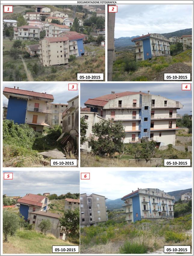
Differential Synthetic Aperture Radar Interferometry (DInSAR)
Differential Synthetic Aperture Radar Interferometry (DInSAR) is a spaceborne remote sensing
technique based on the processing of two (o more) SAR sensor images that allows measuring
displacements affecting targets (buildings, roads, bridges, bare rocks) on the ground with a sub-
millimeter precision on velocity over large areas.
                   Acquisition                                      Stack of images                         Time series

                                                                                                        Velocity map

                                                                                      Available SAR sensors               Tempo

                 Image processing algorithms

 • Permanent Scatterers (PS) (Ferretti et al., 2000)

  • Small Baseline Subset (SBAS) (Berardino et al., 2002)

  • Coherent Point Target Analysis (CPTA) (Mora et al., 2003)

  • Interf. Point Target Analysis (IPTA) (Wegmuller et al., 2005)

  • Enhanced Spatial Differences (ESD) (Fornaro et al., 2007)

  • Multi-Dimensional Imaging tecnique (Fornaro al., 2009)
                                                                                                            (Peduto et al., 2015)
       L’utilizzo dell’interferometria SAR nel monitoraggio delle frane – Prof. Settimio Ferlisi – 3 novembre 2020             2
                                                                                                                             2/32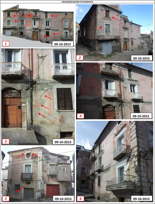
Main applications in the field of Geotechnics/Engineering Geology

          Subsidence                                                      Slow-moving landslides

                                               Seismic faults
L’utilizzo dell’interferometria SAR nel monitoraggio delle frane – Prof. Settimio Ferlisi – 3 novembre 2020     3
                                                                                                              3/32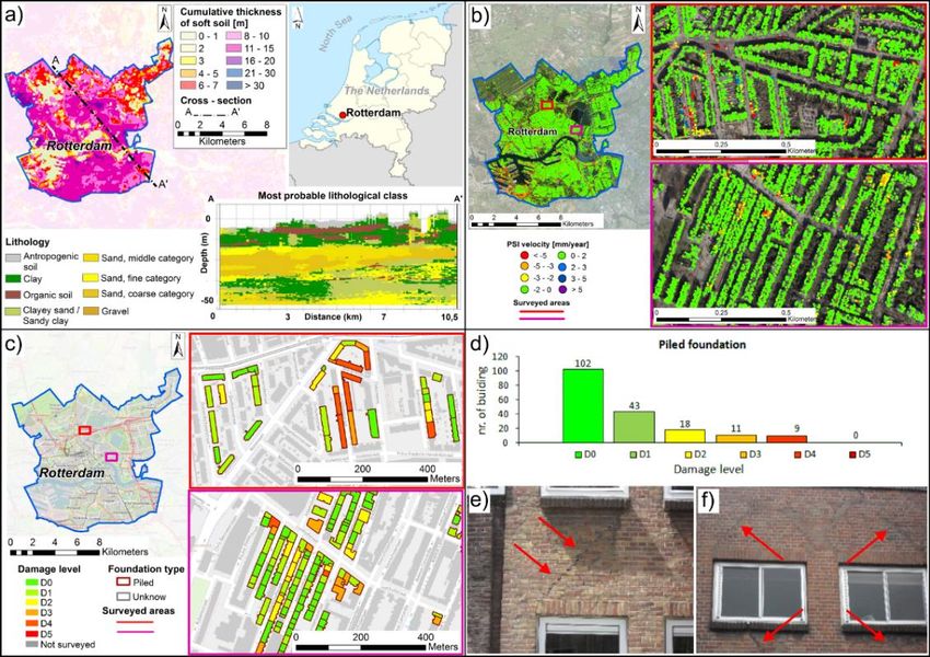
Subsidence: case studies in the Netherlands

a) Cumulative thickness of soft soils; b) distribution of piled
foundation buildings in The Netherlands
                                                                                         DInSAR data accuracy test

                                                   Rotterdam case study

         Damage level vs. differential settlements

Peduto D., Korff M., Nicodemo G., Marchese A., Ferlisi S. (2019).
Empirical fragility curves for settlement-affected buildings: analysis of
different intensity parameters for seven hundred masonry buildings in
The Netherlands. Soils and Foundations, 59: 380–397,
https://doi.org/10.1016/j.sandf.2018.12.009
                                                                                                                          59/73

            L’utilizzo dell’interferometria SAR nel monitoraggio delle frane – Prof. Settimio Ferlisi – 3 novembre 2020      4
                                                                                                                           4/32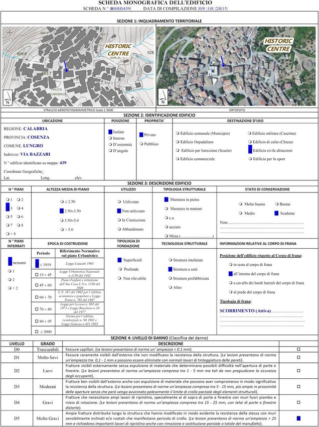
Control of linear infrastructures: bridges

Bridges in Amsterdam city

                                                                                                                     Amsterdam city: subsoil model

                                   Example of damage fact-sheet                                Map of PS over Amsterdam city and accuracy test
Dario Peduto, Francesco Elia, Rosario Montuori (2018) Probabilistic analysis of settlement-induced damage to bridges in the city of Amsterdam (The
Netherlands), TRANSPORTATION GEOTECHNICS, 14: 169–182, https://doi.org/10.1016/j.trgeo.2018.01.002
                                                                                                                                                     64/73

         L’utilizzo dell’interferometria SAR nel monitoraggio delle frane – Prof. Settimio Ferlisi – 3 novembre 2020                                    5
                                                                                                                                                      5/32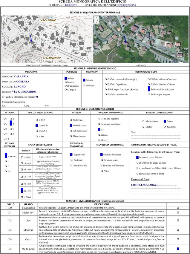
DInSAR application to slow-moving landslides

                         Limits of applications to
                            slope monitoring

L’utilizzo dell’interferometria SAR nel monitoraggio delle frane – Prof. Settimio Ferlisi – 3 novembre 2020     6
                                                                                                              6/32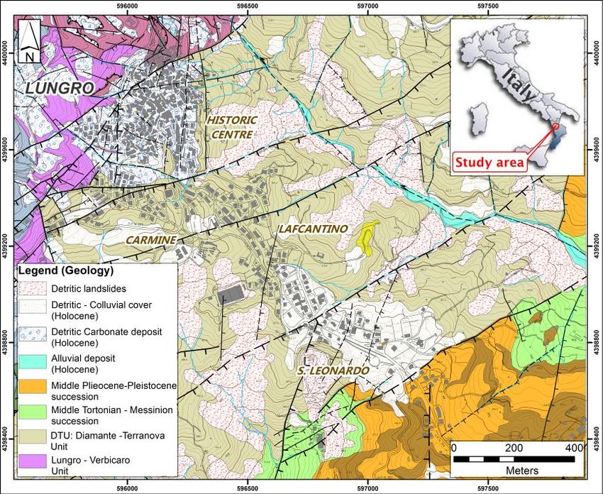
Limits
▪ Vegetated areas, scarsely urbanised
areas (Zebker et al, 1992)
▪ Slope angle effect
▪ Revisiting time (35 day, e.g. for
ESA past satellites) allows
measuring displacements up to
1.4 cm between two acquisitions
▪ Difficult to interpret 3D phenomena via 1D-
LOS information
ra
ng
e
▪ Slope distorsion effects: foreshorthening los
Fore slope range shorthening
displacement
Cascini L., Fornaro G., Peduto D. (2010). Advanced low- and full-resolution DInSAR map
generation for slow-moving landslide analysis at different scales. Engineering Geology, 112 los
(1-4), 29-42, doi:10.1016/j.enggeo.2010.01.003.
L’utilizzo dell’interferometria SAR nel monitoraggio delle frane – Prof. Settimio Ferlisi – 3 novembre 2020 7
7/32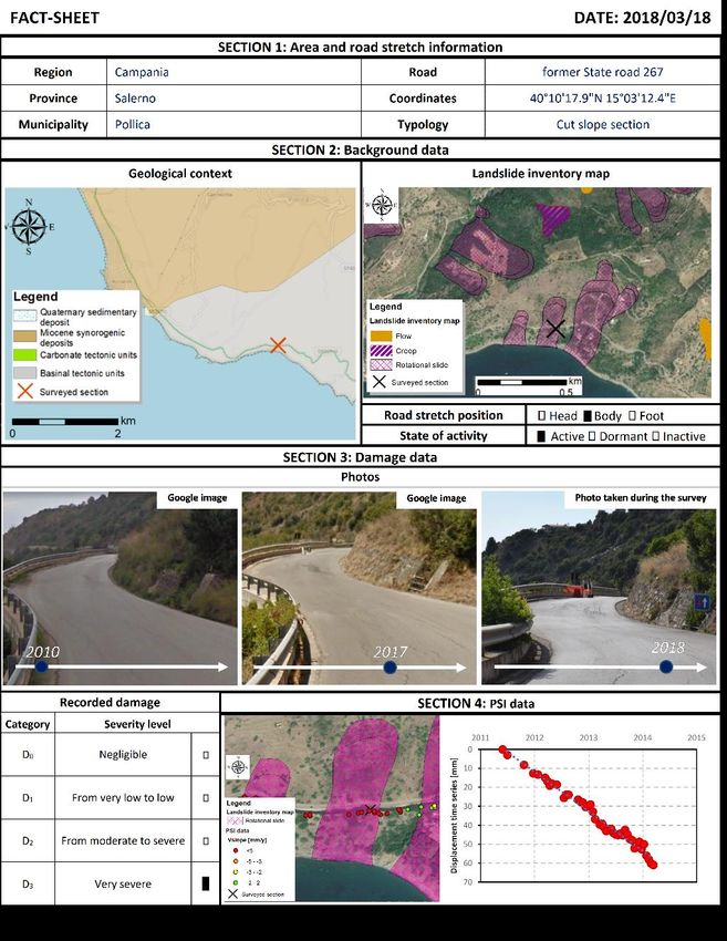
Advanced DInSAR velocity maps for slow-moving landslide applications
Specifically tailored products developed by UNISA:

   Advanced DInSAR landslide
   velocity maps

Trend analysis of
displacement time series

Cascini L., Fornaro G., Peduto D. (2010). Advanced low- and full-resolution DInSAR map generation for slow-moving landslide analysis at
different scales. Engineering Geology, 112 (1-4), 29-42, doi:10.1016/j.enggeo.2010.01.003.
L. Cascini, D. Peduto, Pisciotta G., L. Arena., Ferlisi S. and Fornaro G. (2013) The contribution of DInSAR and facility damage data for the
updating of slow-moving landslide inventory maps at medium scale. Nat. Hazards Earth Syst. Sci., 13, 1527-1549, doi:10.5194/nhess-13-1527-
2013.

          L’utilizzo dell’interferometria SAR nel monitoraggio delle frane – Prof. Settimio Ferlisi – 3 novembre 2020                            8
                                                                                                                                               8/32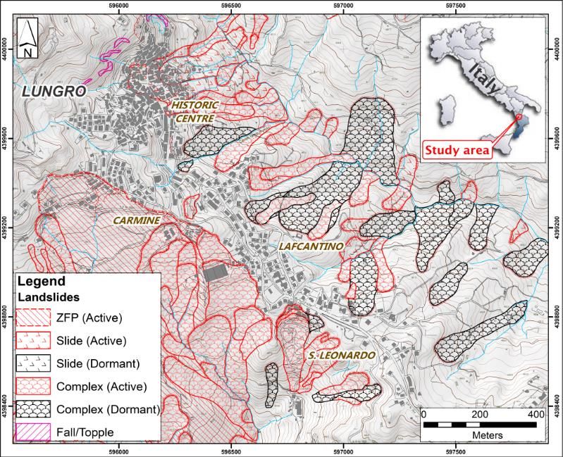
Slow-moving landslides
Slow-moving landslides are widespread in different geological contexts all over the world and,
although they usually have a low probability of generating “catastrophic” events (i.e. a significant loss
of human life), often cause significant damage to structures and infrastructures with them interacting.
                          Characterization                                              Consequences related to slow-moving landslides

                                                                                      (Australia), november 2001
                                                                                      http://www.ccma.vic.gov.au   Castelpagano
                                                                                                                   (Italy), 2012

  Types of slow-moving landslide according to Varnes (1978)

                                                                                      Ireland
                                                                                      http://www.qub.ac.uk         Reino
                              Involved material according to Leroueil et al. (1996)                                (Italy), 2012

                                                                                                                   Reino
                                                                                                                   (Italy), 2012
Velocity of landslides
(Cruden e Varnes, 1996)       Activity stage according to Leroueil et al. (1996)      Montaguto,2006 (DPCN)
                                                                                                                                   3

           L’utilizzo dell’interferometria SAR nel monitoraggio delle frane – Prof. Settimio Ferlisi – 3 novembre 2020                   9
                                                                                                                                       9/32
DInSAR data for slow-moving landslide risk analysis
Landslide risk management framework                                     Scale of analysis: 1:5,000
                                                                        Element(s) at Risk
                                                                                             Vulnerability
                                                                 R=HxExV
                                                              (RISK)

                                                                   Hazard            Crack

                                                                                      dh

                                                                                                  dv

                                                             Landslide characterization
                                                              - State of activity;
                                                              - Landslide mapping.

                                                             Consequence analysis:
                                                              - Identification of elements at risk;
                                                              - Cause-effect relationships.

                                                          Fell et al.(2008)
 L’utilizzo dell’interferometria SAR nel monitoraggio delle frane – Prof. Settimio Ferlisi – 3 novembre 2020     10
                                                                                                               10/32
THE LUNGRO CASE STUDY
L’utilizzo dell’interferometria SAR nel monitoraggio delle frane – Prof. Settimio Ferlisi – 3 novembre 2020 11
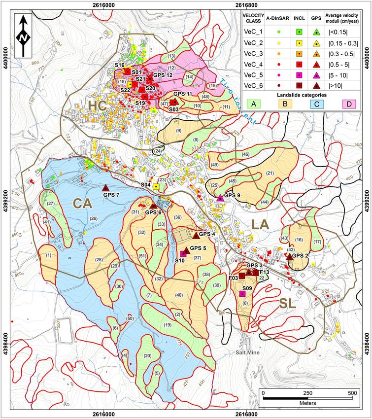
11/32Analysis at municipal scale: the case study of Lungro (CS)
Geological map
The geological setting consists of the Lungro-Verbicaro Unit
(LVU), made up of metapelites and metacarbonates. The LVU,
lying next to the dwelled area of Lungro, moves towards the
Diamante-Terranova with a clear extensional tectonic contact
(Lower Jurassic-Cretaceous), made up of phyllites, blocks of
different natures in a prevalently clayey matrix (Antronico et al.,
2014).
The site of Lungro is characterized by very steep slopes.
Prevailing landslide types are: rotational/translational slides,
complex slide/flow and landslide zone (Greco et al., 2007)
where clustering of phenomena is too tight to distinguish different
bodies. (Data source: CNR-IRPI)
Landslide inventory The monitoring network
Nr.9 GPS
benchmarks
Nr.12 vertical
inclinometers
L’utilizzo dell’interferometria SAR nel monitoraggio delle frane – Prof. Settimio Ferlisi – 3 novembre 2020 12
12/32The case study of Lungro (CS): DInSAR dataset
1992 - 2000 2003 - 2010
SAR
acquisition
R1
R2
ΔR
ERS (PST) data on descending orbit (period 1992 – 2000) ENVISAT (SBAS) data on ascending orbit (period 2003 - 2010)
2012 - 2014
REVISITING RESOLUTION
TIME
COSMO (2012 – 2014) X - BAND
ENVISAT (2003 – 2010) C - BAND
CosmoSkyMed data on ascending orbit (period 2012 – 2014) ERS (1992 – 2000) C - BAND
L’utilizzo dell’interferometria SAR nel monitoraggio delle frane – Prof. Settimio Ferlisi – 3 novembre 2020 13
13/32DInSAR data validation in Lungro
Comparison between displacements derived from DInSAR and S19 inclinometer
measurements from 2006 to 2010 in Lungro (Calabria region, Italy).
Inclinometers DInSAR data
Peduto D., Borrelli L., Antronico L., Gullà G., Fornaro G. (2016). An integrated approach for landslide characterization in a historic
centre. Landslides and Engineered Slopes. Experience, Theory and Practice, Proc. of the 12th International Symposium on
Landslides, Napoli, Italy, 12-19 June 2016, © 2016 , vol.3, pp. 1575-1581.
L’utilizzo dell’interferometria SAR nel monitoraggio delle frane – Prof. Settimio Ferlisi – 3 novembre 2020 14
14/32The Lungro case study
Slow-moving landslide
characterization
at the municipal scale
L’utilizzo dell’interferometria SAR nel monitoraggio delle frane – Prof. Settimio Ferlisi – 3 novembre 2020 15
15/32Landslide characterization at municipal scale: ‘aPosIn’ procedure
GeoG U Geot U Sat methods landslide
Map of typified inventory
landslides
Gullà G., Peduto D., Borrelli L., Antronico L., Fornaro G. (2017). Geometric and kinematic characterization of landslides affecting urban
areas: the Lungro case study (Calabria, Southern Italy). Landslides, 14 (1):171–188, DOI 10.1007/s10346-015-0676-0.
L’utilizzo dell’interferometria SAR nel monitoraggio delle frane – Prof. Settimio Ferlisi – 3 novembre 2020 16
16/32The Lungro case study
Analysis of building
vulnerability to
slow-moving landslides
L’utilizzo dell’interferometria SAR nel monitoraggio delle frane – Prof. Settimio Ferlisi – 3 novembre 2020 17
17/32The case study of Lungro (CS): vulnerability analysis
Input data: ‘detailed’ landslide Landslide inventory map with conventional and innovative
monitoring network (Inclinometers; GPS; DInSAR data)
inventory map
Nicodemo, G., Peduto, D., Ferlisi, S., Gullà, G., Borrelli, L.,
Fornaro, G., Reale, D. (2017). Analysis of building vulnerability
to slow-moving landslides via A-DInSAR and damage survey
data. Proceedings of the 4th World Landslide Forum – Ljubljana,
Slovenia, May 29 – June 02, 2017, pp. 889-907,
doi:10.1007/978-3-319-53498-5_102.
L’utilizzo dell’interferometria SAR nel monitoraggio delle frane – Prof. Settimio Ferlisi – 3 novembre 2020 18
18/32Phase I at detailed scale: Exposed elements
Identification of the exposed buildings
Topographic map Typified landslide inventory map Map of exposed buildings
Classification of damage levels via ad hoc predisposed fact-sheets
The fact-sheets consist of different sections that
allow systematical recording of the archive
information regarding:
1) Location area
2) building information (i.e. ownership, structural
typology, foundation type, n° floors, etc.)
3) damage severity level;
4) field survey photos;
(Ferlisi et al., 2015; Nicodemo et al., 2017) 5) DInSAR-derived intensity parameters.
L’utilizzo dell’interferometria SAR nel monitoraggio delle frane – Prof. Settimio Ferlisi – 3 novembre 2020 19
19/32Phase I at detailed scale: examples of fact-sheets filled in during in situ damage survey
R.C. building
L’utilizzo dell’interferometria SAR nel monitoraggio delle frane – Prof. Settimio Ferlisi – 3 novembre 2020 20
20/32Phase I at detailed scale: examples of fact-sheets filled in during in situ damage survey
Masonry building
L’utilizzo dell’interferometria SAR nel monitoraggio delle frane – Prof. Settimio Ferlisi – 3 novembre 2020 21
21/32Phase I and II at detailed scale: damage classification and interpretation
Damage classification (adopted by Burland et al., 1977)
Map of damage distribution on typified landslides
Statistics of the damage survey of 2015
L’utilizzo dell’interferometria SAR nel monitoraggio delle frane – Prof. Settimio Ferlisi – 3 novembre 2020 22
22/32An example of the potential of DInSAR data in monitoring building damage evolution in time
Building located on the
boundaries of an active roto-
translational slide
Peduto et al.(2017)
Increase of damage severity with the time
DInSAR time-series
L’utilizzo dell’interferometria SAR nel monitoraggio delle frane – Prof. Settimio Ferlisi – 3 novembre 2020 23
23/32Phase III at detailed scale: cause-effect relationships
Differential settlements () vs. damage level (buildings located in slow-moving landslide area)
Differential settlements were computed for each building
as the maximum difference of the cumulative settlements
recorded by the coherent pixels within its perimeter.
The cumulative settlements were derived by multiplying
the average velocity along the vertical direction (i.e.
derived from the Line of Sight sensor-target direction) for
the period of observation of each available dataset.
Reinforced concrete buildings (12 single buildings) Masonry buildings (37 single buildings)
Peduto D., Ferlisi, S., Nicodemo G., Reale D., Gullà G. (2017). Empirical fragility and vulnerability curves for buildings exposed to slow-moving
landslides at medium and large scales. Landslides, 14(6): 1993-2007, doi:10.1007/s10346-017-0826-7
L’utilizzo dell’interferometria SAR nel monitoraggio delle frane – Prof. Settimio Ferlisi – 3 novembre 2020 24
24/32Phase III at detailed scale: empirical fragility and vulnerability curves
Analysis of damage frequency:
by adopting a cumulative log-normal distribution function
(Saedi at al., 2009, 2012; Negulescu et al., 2010; Mavrouli
et al., 2014; etc), empirical fragility and vulnerability curves
were derived for masonry buildings with reference to
damage level ranging from D1=slight to D5=very severe:
= standard normal cumulative distribution function;
= maximum differential settlements;
= median value of at which the building reaches each damage level ;
β = standard deviation of the natural logarithm of for each damage level
Empirical fragility curves for masonry buildings Empirical vulnerability curve for masonry buildings
Expected damage
Regression model
Peduto D., Ferlisi, S., Nicodemo G., Reale D., Gullà G. (2017). Empirical fragility and vulnerability curves for buildings exposed to slow-
moving landslides at medium and large scales. Landslides, 14(6): 1993-2007, doi:10.1007/s10346-017-0826-7
L’utilizzo dell’interferometria SAR nel monitoraggio delle frane – Prof. Settimio Ferlisi – 3 novembre 2020 25
25/32Expected Building Monetary Loss in time
Flowchart of the methodology Monetary Estimation EXPECTED MONETARY LOSS
Ordinary condition 5 years Critical condition
10 years
(homogeneous areas) Value of exposed elements Ordinary condition Critical condition
Peduto D., Nicodemo G., Caraffa M., Gullà G. (2018). Quantitative analysis of consequences to
masonry buildings interacting with slow-moving landslide mechanisms: a case study. Landslides,
15(10): 2017-2030, DOI 10.1007/s10346-018-1014-0.
L’utilizzo dell’interferometria SAR nel monitoraggio delle frane – Prof. Settimio Ferlisi – 3 novembre 2020 26
26/32The contribution of DInSAR and
damage survey data to the analysis of
risk to road networks
25/38
L’utilizzo dell’interferometria SAR nel monitoraggio delle frane – Prof. Settimio Ferlisi – 3 novembre 2020 27
27/32Risk analysis for road networks: a case study in Campania region
Flowchart of the proposed methodology for QRA
Examples showing the
criteria adopted to define
the length of buffer/s
Road damage severity levels classified as a D0 (negligible), b D1 (from
very low to low), c D2 (from moderate to severe), and d D3 (very severe)
The study area and available dataset
Ferlisi S., Marchese A., Peduto D. (2020) Quantitative analysis of the risk to road networks exposed to slow-moving landslides: a case study in the
Campania region (southern Italy). Landslides, DOI 10.1007/s10346-020-01482-8 35/38
L’utilizzo dell’interferometria SAR nel monitoraggio delle frane – Prof. Settimio Ferlisi – 3 novembre 2020 28
28/32Risk analysis for road networks: a case study in Campania region
Ferlisi S., Marchese A., Peduto D. (2020) Quantitative analysis of the risk to road networks exposed to slow-moving landslides: a case study in the
Campania region (southern Italy). Landslides, DOI 10.1007/s10346-020-01482-8
36/38
L’utilizzo dell’interferometria SAR nel monitoraggio delle frane – Prof. Settimio Ferlisi – 3 novembre 2020 29
29/32Risk analysis for road networks: a case study in Campania region
The probabilities of occurrence
of slow-moving landslides of a
given intensity level
Fragility and vulnerability curves
Expected average damage (μD) vs. relative repair cost (RRC)
Ferlisi S., Marchese A., Peduto D. (2020) Quantitative analysis of the risk to road
networks exposed to slow-moving landslides: a case study in the Campania region
(southern Italy). Landslides, DOI 10.1007/s10346-020-01482-8
30/38
L’utilizzo dell’interferometria SAR nel monitoraggio delle frane – Prof. Settimio Ferlisi – 3 novembre 2020 30
30/32Remarks
✓ DInSAR data currently offers a huge dataset of displacement data that
can be integrated with conventional methods for monitoring building
displacement/settlements at different scales of analysis.
✓ The proposed procedure for landslide characterization and the analysis of
building vulnerability to slow-moving landslides allowed typifying landslides
and the retrieval of preliminary relationships between the damage severity
and the selected DInSAR-derived intensity parameters (i.e. differential
settlements) for different structural typologies (i.e. reinforced concrete and
masonry buildings).
✓ The achieved results highlight a general increasing trend of damage severity
with intensity, independently from both the scale of analysis and the structural
typology.
✓ The advantage of using such a widespread information as DInSAR data also
brought to the generation of empirical fragility and vulnerability curves
that, once further validated, may open new perspectives for helping
authorities in charge of land use planning to select most suitable zones
to be urbanized also addressing restoration and adaptation policies.
✓ The further improvements may take into account other relevant factors,
among others: foundation typology; position of the structure within
landslide body; etc. This will also call for enriching the dataset.
L’utilizzo dell’interferometria SAR nel monitoraggio delle frane – Prof. Settimio Ferlisi – 3 novembre 2020 31
31/32Thank you for the attention
Settimio FERLISI, PhD
Associate Professor in Geotechnical Engineering
Department of Civil Engineering – DICIV
University of Salerno (ITALY)
Via Giovanni Paolo II, 132 - 84084
www.unisa.it – sferlisi@unisa.it
38/38
L’utilizzo dell’interferometria SAR nel monitoraggio delle frane – Prof. Settimio Ferlisi – 3 novembre 2020 32
32/32You can also read