Land Use Issues and Options Discussion Paper
                April, 2021
←
→
Page content transcription
If your browser does not render page correctly, please read the page content below
Land Use Issues and Options Discussion Paper
April, 2021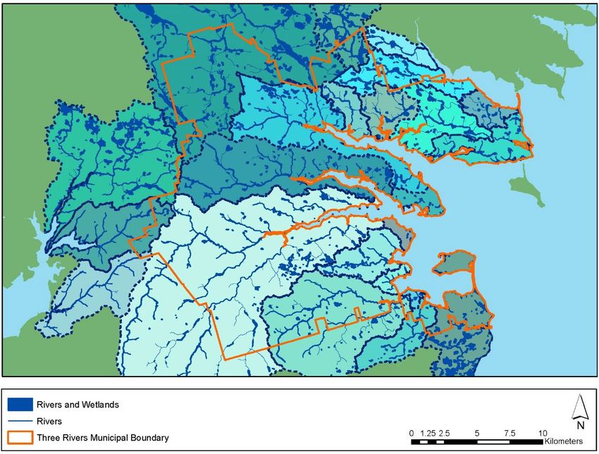
Identified Issues and Policy and Regulatory
Solutions
This Discussion Paper is intended to address identified challenges within the land use planning
system in Three Rivers. Each section generally contains a description of the challenge, and a
discussion of possible policy and regulatory solutions that can be implemented through the
Official Plan or Development By-law.

1.1. Processes and Procedures
Several stakeholders, including Planning Board members, Town Staff, and members of the
development industry, identified inconsistencies in planning processes and procedures among
the former municipalities. For example, permit requirements and timelines remain poorly
defined or misunderstood, indicating a need for clarification on the following issues:
   /   Which applications are, or may be, delegated to the Town Development Officer(s);
   /   Inconsistencies or lack of terminology for types of development;
   /   Clarification on which policies are compulsory, and which are aspirational;
   /   Requirement to clarify policies and regulations to distinguish between “Development
       Permits” and “Building Permits”;
   /   Timelines for applications and clarification on expected outcomes;
   /   Requirements for a complete application and when an application may be placed on
       hold or closed;
   /   Validity of permits, including expiry dates and which stage of development process
       triggers a violation;
   /   Clarification on responsibility for by-law enforcement;
   /   Schedule of fines (either in Development By-law, or as a separate by-law); and
   /   Clarification of the authority of the Development Officer.
The majority of the identified issues will be addressed through the Development By-law, which
establishes overall processes and procedures for development activities in the Town. In
particular, details of the permit process will be established in the by-law regulations. Some
elements may be addressed in a more general way in the Official Plan, such as requirements
for a complete application.

1.2. Community Structure and Form
As a result of the amalgamation of the former municipalities and rural areas, the Town of Three
Rivers features a diverse complexion of character areas, including serviced urban areas,
agricultural lands, rural villages, shorelines and waterfronts, industrial areas, and natural
environmental features. A principal goal of the Official Plan is to create a growth management
plan and land use policy designations that recognize existing community character and
development patterns, while enabling opportunities for appropriate growth and development in
the future.

                                                                                              2
1.2.1. Settlement Areas
One policy option available to the Town is to create defined settlement area boundaries around
Montague and Georgetown. The purpose of defining a settlement area would be to
differentiate the urban character areas from the rural areas, intended to avoid the inefficiencies
and land use conflicts deriving from urban or suburban-type development in the rural area. As
development demand is typically higher in close proximity to urban areas, a settlement area
boundary enables a policy response to limit the “sprawling,” or dispersed, tendency of
development outside established areas.
As the only two areas in Three Rivers with central water and sanitary services, a settlement
area boundary also serves to define in policy properties which are eligible to receive public
services, in contrast to those not granted this status. In addition to creating certainty among
the public and landowners as to where servicing will be provided, this policy approach will
provide a policy basis for Town Council to adjudicate the appropriateness of requests for
expansion of the services. While Council retains the right to amend its Official Plan policies, the
standard approach is for applications for servicing expansions outside of settlement areas to
be refused.
Underlying the settlement area approach is responsible management of municipal assets and
finances. Where public services are deliberately limited within a settlement area boundary, the
danger of inefficient or uneconomical expansion of public services is reduced. While funding
for central servicing infrastructure is often received from other orders of government, a land
use plan that envisions efficient servicing provision reduces strains on local, provincial, and
national tax base, as well as limiting user fees. Notably, while infrastructure installation costs
may be covered by development charges or funding arrangements, operational costs continue
in perpetuity and are generally taken from the local economy through user fees or property
taxes.
Settlement areas also represent a focus for more intensive forms of development. In contrast
with the low-density and dispersed forms of development in the rural area, settlement areas
are defined by more compact development forms, including smaller land parcels, more
intensive building types, and a wider range of land uses. As a result of this compact
development form, the settlement areas enable proximities and synergies between land uses,
creating a focal point for economic and social activities. The close proximity also allows
residents and visitors to engage in active modes of transportation to access employment,
education, and local services.
The settlement area approach may also be used for the developed area of Cardigan, which
features a comparatively compact form of rural development. In contrast with Montague and
Georgetown, central water and sanitary services are not offered in Cardigan, but nonetheless
represents a central hub of a range of land uses. A policy approach for Cardigan could include
the creation of a Rural Settlement Area to reflect the unique needs of the community, intending
to recognize servicing conditions while permitting an appropriate range of land uses.
If established, settlement areas would be fixed for the life of the Plan, but may be amended by
Council through an Official Plan review process, legislated to be completed every five years.
Modifications to the settlement area boundary are also possible through an Official Plan

                                                                                                 3
Amendment process at any time, but are not recommended, in order to maintain the integrity
of the designation.
In the Three Rivers context, Montague, Georgetown, and Cardigan previously experienced a
type of quasi-settlement area created through municipal boundaries. As municipal jurisdiction
ended at the Town boundary, there was generally a natural limit to servicing expansion, and
the responsibilities of utility corporations were right-sized accordingly. In the rare instances
where public services were extended beyond municipal boundaries, cumbersome financial and
administrative arrangements were required across municipalities. Seen in this light, the
establishment of settlement areas will not be a radical departure from previous conditions, and
will better coordinate the provision of public services in the amalgamated Town.
1.2.2. Alternative to Settlement Areas
If Council chooses not to implement settlement area policies, the Official Plan could instead
contain a section with more robust policies addressing provision of public services. In this
approach, policies could establish criteria for evaluation of proposals to expand central
services, such as demonstrating need, confirming system capacity, and establishing a source
of funding. These policies would apply both to applications by private landowners, as well as
proposals by the Town of Three Rivers.
In this alternative approach, Council may choose to accompany the servicing expansion
evaluation criteria with more site-specific land use policies that enable the mix and densities of
land uses commonly associated with a settlement area.
1.3. Community Character
Community members in all parts of Three Rivers expressed a strong desire to maintain the
character of their home communities, typically corresponding to one of the former component
municipalities. In particular, rural dwellers fear inappropriate development or excess regulations
in their areas as a result of the amalgamation.
Through engagement activities, residents expressed a commonly-held fear that new planning
rules will apply uniformly across the entire Town, without regard for existing community
context. For example, rural residents identified concerns that urban-centric policies and
provisions designed for Montague and Georgetown would apply concurrently to rural areas,
including permitted land uses and development standards.
A principle of good community planning is to recognize the character of areas and adopt
policies to maintain the desirable attributes of unique areas. While change is inevitable and
new development will always bring new features to a street, neighbourhood, or community,
one of the primary purposes of planning is to capture and protect important elements in land
use policies.
Foresight in planning is also critical in the planning process, to account for anticipated future
changes and direct development activities to best-suited areas.
Considering the existing diversity of character areas among the former communities of the
amalgamated Town, Official Plan policies should reflect both the existing and planned
4characters of the various areas of Three Rivers. This dual approach seeks to balance a
recognition of existing conditions with desirable future conditions for each character area.
1.4. Previously-Unincorporated Areas
Rural areas of the Town that were previously not included in former municipalities have
historically been subject to provincial planning regulations for development activities. These
regulations will continue to apply in these areas until the new Official Plan and Development
By-laws are in full force and effect.
In engagement activities throughout the project, several community members expressed
concerns that a new planning regime within the amalgamated municipality would result in new
regulations on development. In general, these residents registered their desire that current
provincial regulations be maintained in these rural areas.
While the devolution of jurisdiction for planning matters in these areas from the province to the
Town of Three Rivers is non-negotiable, the extent and nature of new policies and regulations
will be subject to Council direction.
Current regulations in these areas generally affect lot creation (subdivision), road access,
private servicing requirements, setbacks, parking requirements, and minimal restrictions on
land use. The new policies and regulations will address all of these aspects of development
across the Town, and direction must also be provided to all rural areas.
In contrast to planned communities, the provincial regulations serve to provide only limited
control on development. The regulations are not rooted in any land use planning policies, and
therefore do not contribute to wider planning goals, such as protection of agricultural uses,
preservation of rural character, compatibility among land uses, and other considerations.
Similarly, the regulations are distinct from zoning provisions, which enables better and context-
specific regulation of land uses and more nuanced setback requirements.
Additionally, planning permissions on lands subject to the Province-Wide Regulations do not
require a public consultation process. For example, new developments proposed under a
municipal planning regime typically feature a public engagement component, whereas such
engagement is not required for new developments in unincorporated areas. Furthermore, the
regulations are approved and amended by Provincial Cabinet, with no opportunity for public
input.
Council may choose to use the existing provincial regulations as a basis for provisions applied
to the rural area in the new Development By-law. The benefits of this approach include
familiarity by some residents and ease of drafting these sections of the planning documents.
However, there are several disadvantages to adhering too faithfully to the existing provincial
regulations in the Three Rivers by-law, including:
/ Inconsistency within the rural area of Three Rivers: The character of the
unincorporated areas is generally similar to the rural areas located in the former
municipalities. Applying a different set of policies and regulations to these areas may be
considered unfair to some rural property owners, particularly considering all properties
now fall within the same municipality and are otherwise subject to identical by-laws and
5tax structure. Additionally, over the longer-term, inconsistencies in planning regulations
may seem anachronistic, once former municipal boundaries lose relevance in the
amalgamated municipality.
/ Achievement of planning goals: In contrast with the provincial government, planning
in the Town of Three Rivers will be a policy-led regime in the future, which will be
established to ensure the realization of good planning and community development
goals. Applying a hierarchy of policies and regulations across the rural area may
undermine the ability to meet these planning goals. For example, if Council elects to
adopt policies to enhance protection of agricultural lands, enforcement through the
Development By-law may require restrictions on land use and lot creation beyond those
currently enforced by the province. Additionally, achievement of these goals may be
particularly challenging at the interfaces between the formerly incorporated and
unincorporated areas, where the form of development in close proximity to each other
may be different, potentially generated land use conflicts.
/ Difficulty of administration: The Town of Three Rivers will be responsible for the
administration and monitoring of the new planning documents, including consulting
with developers and landowners, processing applications, and approving or refusing
application requests. Applying a different set of regulations in parts of the rural area
may cause confusion among applicants, Staff, the Planning Board, and Council, and
may require additional time and effort to clarify understanding. Additionally, the
planning documents themselves would require separate policies and provisions for
different rural areas, adding complexity to the documents and maps.
/ Changes by provincial government: If Council chooses to assign the current
provincial standards to the previously unincorporated areas verbatim, the regulations
will eventually become outdated if the Province of Prince Edward Island amends the
regulations in the future. In the event that provincial Subdivision and Development
Regulations change, the Town will be faced with the choice to either amend its planning
documents to remain consistent with provincial regulations, requiring a public process,
or to remain inconsistent with provincial regulations.
1.5. Servicing
The expansion of public water and sanitary services is a key element in facilitating safe and
efficient development in the Town. While the former Towns of Montague and Georgetown were
the only municipalities in Three Rivers to offer public water and sanitary services prior to
amalgamation, the removal of municipal boundaries enables the Town to explore opportunities
for expansion of these services to other areas.
Rather than establish new public utilities and servicing infrastructure elsewhere in the Town, it
is most cost-effective to expand existing services into currently unserviced areas to enable
future urban development. The expansion approach also results in efficiencies for other
utilities, administration, and related infrastructure as a result of new development being
contiguous with existing urban areas. For example, establishing new services would generally
result in a capacity for a higher density of development, which typically requires a higher-order
6road network and electricity infrastructure. In contrast, much of this infrastructure is already
present, or can be easily extended adjacent to already-serviced areas.
The Town of Three Rivers is currently engaging a consulting engineer to prepare a Servicing
Master Plan for the Town, which will survey existing conditions of central services and make
recommendations for future expansions. If the Master Plan is completed during the duration of
the Official Plan project, policies can incorporate its findings.
1.5.1. Increasing Efficiency
A potential market-based policy solution is for utilities to begin charging, or enhance, frontage
fees, as enabled by the Municipal Act. Section 184 of the Act allows for both rates and
frontage charges to be levied on serviced land by a municipal Council on behalf of a utility
corporation, to a maximum of 152 metres (500 feet). Applying a frontage charge would
incentivize more compact forms of development on lands serviced with public water and
sanitary services.
While the Water and Sewerage Act requires that rates and charges be determined in
accordance with the generally accepted public utility practices after taking into consideration
local conditions and circumstances, the Town of Three Rivers may wish to investigate the
application of frontage charges as a means to create efficient development patterns within
settlement areas.
1.6. Heritage
The Municipal Act establishes that municipalities have jurisdiction over the protection of
heritage property. Although the provincial and federal governments designate and manage
most of the heritage sites on Prince Edward Island, there remains an opportunity for the Town
of Three Rivers to introduce further Official Plan policies and regulations for the protection of
these resources.
Additionally, the Heritage Places Protection Act enables the Minister to devolve authority on
heritage protection to municipalities, upon agreement. The Town of Three Rivers may wish to
exercise more authority on local heritage matters, including designating heritage resources. If
the Town wishes to avail itself of this option, the Implementation section of the Official Plan can
include direction for Council to prepare a Heritage Plan and begin discussions with the Minister
regarding these powers.
1.7. Protection of Agricultural Lands
The Province of Prince Edward Island has enacted legislation and regulations that address
concerns about the loss of agricultural land on the Island, including the Lands Protection Act,
Minimum Distance Guidelines, and some development regulations. Despite these measures,
and in the absence of a province-wide policy basis for land use activities across the province,
agricultural land enjoys a comparatively low level of protection at the provincial level.
Members of the Three Rivers community have identified protection of agricultural land as a
value for the rural areas, for various economic and cultural reasons. Strong protection of
agricultural land through policy can be found in several provinces across Canada, notably
7British Columbia (through the Agricultural Land Reserve) and Ontario (through the Provincial
Policy Statement and Greenbelt Plans), as well as Québec (CPTAQ) and Newfoundland and
Labrador. In those provinces, municipalities are responsible for achieving a minimum standard
of protection of agricultural lands where the restrictions apply, but may also provide enhanced
levels of protection.
In many places, protection of agricultural land is viewed as comprising part of a broader food
systems approach, which provides economic, environmental, health, and cultural benefits to
the broader community. The positive feedback effects of agricultural protection translates into
support for the agricultural industry in general, as well as protection of water resources, and
viability for local food production.
Through the creation of the new Official Plan and Development By-law, the Town of Three
Rivers has an opportunity to enhance the level of protection of agricultural lands, if it chooses
to do so. Any degree of protection would be tailored to the Three Rivers context, and would be
implemented through a variety of planning tools.
There are several principal aspects to agricultural protection:
/ Designation of agricultural lands;
/ Restriction of land uses on agricultural lands;
/ Restriction of land uses adjacent to agricultural lands;
/ Limitations on land division within agricultural lands; and
/ Where land division is permitted, limitations on lot size and / or lot frontages.
These aspects are discussed in detail below.
1.7.1. Designation
If Council elects to enhance protection of agricultural lands, it first must determine which lands
qualify as “agricultural.” Areas with existing agricultural operations can be a good indicator of
which lands could qualify for this designation, particularly if livestock operations are present.
However, this metric does not account for good-quality land that may be suitable for
agriculture, but which does not presently feature operations.
The Canada Land Inventory (CLI) classification system is a good indicator of soil quality, and
may be used to refine a potential map of agricultural lands. Lands are categorized on a scale of
1 to 7, with Category 1 lands having the highest potential for agricultural uses, and Category 7
lands having the lowest potential. In general, rural lands within the Town of Three Rivers
contains lands predominantly classified between Category 2 and Category 4.
Any designation for agricultural protection must also consider areas designated for expansion
of urban and non-agricultural rural uses. Areas identified for these purposes should be
excluded from the protected areas to ensure the planning framework enables the envisioned
land uses.
1.7.2. Restriction of Land Uses on Agricultural Lands
Within a designated agricultural protection area, the Official Plan and Development By-law
would restrict the permitted land uses to agriculture and agricultural-related land uses.
8Complementary land uses would be permitted, as well as natural environmental features.
Residential land uses would generally be restricted to one single-detached dwelling per lot.
The rationale for restricting land uses in the agricultural protection area is two-fold. First,
limiting land uses avoids conflicts between agricultural activities and non-compatible uses,
which may compromise the integrity of the agricultural land. Second, restricting land uses
reduces land speculation on agricultural lands, preventing variable increases in land value that
are unrelated to the value of agricultural practice.
1.7.3. Restriction of Land Uses Adjacent to Agricultural Lands
Land use conflicts with agricultural uses may occur on parcels that are not designated for
agricultural protection. For example, odour impacts from livestock operations may extend
across designation boundaries onto residential or other sensitive land uses.
The provincial Guidelines for Manure Management can be used to formulate a policy to
consider proximity of new residential land uses to livestock operations, and visa-versa. These
policies may be applied as strict requirements, or as guidelines for review by the Town,
depending on Council direction.
1.7.4. Limitations on Land Division Within Agricultural Lands
A prominent consideration in preserving agricultural land is the potential for fragmentation of
the lot fabric. With rare exceptions, agricultural practices require large areas of land to ensure
effective operations, and the creation of smaller lots through subdivision simultaneously
removes land from viable agricultural production, introduces potential conflicts from the new
land use, and creates a new lot that is almost certain to not be used for agricultural purposes in
the short or long term.
Given the market for estate lots on Prince Edward Island, there will continue to be pressure to
subdivide properties in the agricultural area. Measures to achieve the protection of agricultural
lands would include restrictions on the number of parcels that can be created through
subdivision, both to preserve agricultural parcels and to direct housing to more appropriate
locations.
The number of parcels permitted in the agricultural protection area would be subject to Council
direction. The policy direction should aim to strike an appropriate balance between protection
of agricultural areas and maintaining the ability for landowners to sever individual lots for family
members or to finance retirements. In a strong protection scenario, lot creation would be
limited or prohibited altogether. Alternatively, a policy approach that afforded weaker
protections would permit a higher number of lots and further fragmentation of agricultural lands
within Three Rivers.
As an example, the Towns of Cornwall and Stratford permit the creation of two new land
parcels from existing lots. In these municipalities, the term “existing lot” has been criticized as
being too broad, as it would conceivably include recently-created parcels at the time of
application. To remedy this challenge, the Official Plan may establish a “starting point” date,
whereby lots in existence on that date would be afforded the ability to request the creation of
9new lots, to the maximum limit. A logical date may be the date of Council adoption of the
Official Plan, or some other date of Council’s choosing.
Limitations on land division would generally be established in the Official Plan policies and
provide guidance for consideration of subdivision applications.
1.7.5. Limitations on Lot Size and / or Lot Frontages
To the extent that land division is deemed by Council to be appropriate, it is recommended
that permitted lot sizes be restricted in the policy and regulatory framework. Requirements
should incorporate a balance between the minimum lot size requirements to enable effective
private servicing, while ensuring that agriculture can remain as viable as possible.
The policy and regulatory approach may include different standards for residential lots, and
may also include large minimum lot sizes (e.g. 10 hectares or more) for retained lands to
ensure agricultural viability.
1.7.6. Alternative to Agricultural Land Protection
Despite the options for agricultural land protection outlined above, Council may elect to
maintain the status quo and incorporate fewer protections for agricultural lands, or no
protections at all. In that scenario, policies could continue to permit agricultural uses among
other rural uses, and could direct the Town to review applications for new housing with regard
for surrounding agricultural uses.
Alternatively, the new Official Plan may identify Rural lands in addition to designated
Agricultural lands. While the Rural designation would permit agricultural uses, the policies for
land uses and lot creation would be more permissive, allowing for greater flexibility. This
designation would most appropriately be generally applied to lands with a lower potential for
agriculture, or in rural areas that do not feature agriculture as a prominent land use.
1.8. Approved Legacy Lots
The Vacant Land Analysis reveals that the Town of Three Rivers has an abundance of legacy
lots within its boundaries. These lots are generally outside the urban areas, and were typically
approved by the Province of Prince Edward Island.
Some of these lots are now undevelopable due to rising sea levels, and many owners have
reportedly stopped paying taxes on the lots. Additionally, many of the lots are undersized, with
lot areas below the required 25,000 square feet currently required by Provincial regulations.
The Town of Three Rivers may elect to incorporate policies in the Official Plan, including the
following:
/ Policies that recognize and permit development on existing undersized lots,
conditionally upon demonstrating that the lots can be safely and effectively serviced
with private water and sewage systems;
/ Policies that prohibit development on waterfront lots that are currently, or projected to
be, rendered undevelopable due to rising sea levels; and
/ Policies that encourage consolidation of undersized lots with adjacent compliant lots.
10Where appropriate, these new policies may be informed by policies in other Official Plans in
municipalities such as Stratford, Cornwall, and Miltonvale Park. These Plans contain policy
direction for these legacy lots, including controls for engineered on-site septic systems and lot
coverage restrictions.
1.9. Private Roads
The proliferation, quality, and status of private roads was raised by several stakeholders in
interviews throughout the engagement process. In general, many subdivisions on rural lands
are established on the basis of private roads, responsibility of which is assigned to
Homeowners Associations or Condominium Corporations representing the benefitting lots.
1.9.1. Comparison with Public Roads
The preference for public roads to service properties is generally a well-founded planning
principle in communities across Canada and internationally. The provision of public road rights-
of-way for the common benefit dates back centuries, with an early recognition of the
efficiencies gained by allocating linear corridors of land for public uses.
By definition, public roads are open to all, allowing for free movement for all citizens and
creating a more sociable public realm. Public roads are also designed to acceptable standards
that ensure safety for all users and vehicle types, as well as ensuring a functional, efficient, and
coordinated approach to transportation infrastructure. Similarly, in many cases, public road
rights-of-way provide an opportunity to co-locate other forms of linear infrastructure, including
pipes, sewers, electrical lines, natural gas lines, and telecommunications cables.
In particular, public roads enable direct access for critical services, including emergency
services, deliveries, waste collection, maintenance services, and similar activities requiring
direct access. The general requirement for land parcels to be located on public roads and the
need to properly maintain these roads are reflective of the importance of these critical services.
In Prince Edward Island, the majority of roads are owned by the Province, particularly outside
of the largest municipalities.
1.9.2. Permissions for Private Roads
While public roads remain the preferred ownership structure for road rights-of-way, many
municipalities across Canada permit the establishment of private roads in limited
circumstances. In general, private roads are typically created to service developments such as
small-scale residential subdivisions, retail developments, institutional campuses, and similar
development forms.
In most communities, private roads are typically present in the following forms of residential
developments:
/ Subdivisions containing seasonal dwellings;
/ Subdivisions containing freehold lots in which a Homeowners Agreement governs
maintenance for the private road and other infrastructure; and
/ Plans of Condominium.
11Where permitted, private roads in many jurisdictions remain subject to minimum design and
governance standards, including minimum corridor width, engineering standards, and the
requirement for maintenance agreements. These standards are generally established through
land use policies, zoning requirements, or municipal engineering standards.
1.9.3. Challenges of Private Roads
In Three Rivers, and in Prince Edward Island generally, there is a lack of regulation governing
the approvals, design, and maintenance of private roads. For example, the Planning Act
Regulations for Subdivision and Development prohibit development on private roads, but
establish broad exceptions that undermine the efficacy of the regulation in many cases.
Several stakeholders identified concerns related to the current policy and regulatory regime for
private roads. Specifically, the stakeholders identified the following concerns:
/ There are no design standards, such as minimum width or surfacing, to ensure safety
and access for emergency and service vehicles;
/ There are no requirements for stormwater management, resulting in potential pooling or
flood hazards;
/ A lack of review process for a planning authority to ensure adequacy of the private road
designs;
/ Inevitable pressures to convert private roads to public status, resulting in increased
responsibility for municipal governments;
/ Conflicts regarding private road maintenance among landowners, who may have
different expectations, preferences, tolerances, means, or tenure arrangements; and
/ Exceptions enabling private roads incentivizes development of new housing in rural
areas, rather than supporting established settlement areas with new subdivisions.
1.9.4. Policy and Regulatory Solutions
With the new Official Plan and Development By-law, Three Rivers has an opportunity to
remedy the challenges and drawbacks that accompany private roads. There are three policy
and regulatory responses available to Council:
1) Status Quo
The Status Quo option represents no change to the current permissions for private
roads. In this scenario, private roads would be prohibited in the Official Plan and
Development By-law, but would reflect the set of exceptions established in the Planning
Act Regulations. If the Status Quo option is selected, the challenges outlined above are
anticipated to continue.
The Status Quo option would require a basic policy and regulatory approach, with
provisions outlining the exceptional cases in which private roads are permitted. While
there is minimal financial cost for Town Staff resources, there may be some costs
related to enforcement by Staff, and pressures for the Town to assume or maintain
private roads would remain.
122) Prohibit Private Roads
The Prohibit option represents a marked change to current permissions. In this
scenario, private roads would be prohibited with no exceptions, representing a more
restrictive approach than the Planning Act Regulations. If private roads are prohibited in
all cases, the challenges identified above would be resolved or rendered moot in all
future development.
The Prohibit option is the easiest to administer, as no private roads would be permitted
in any scenario. Minimal policies and regulations would be required to enforce this
approach. Consequently, there are no financial costs to the Town associated with this
option.
3) Permit and Regulate Private Roads
The Permit and Regulate option generally permits private roads in exceptional cases,
but regulates their design and construction. Council may determine the cases in which
private roads would be permitted, but may be generally modelled on the Planning Act
Regulations. In this scenario, the challenges identified above would generally be
mitigated in future development.
The Permit and Regulate option would result in a more balanced policy and regulatory
approach, but requires the Town to establish standards for design and construction of
private roads. These new standards would likely reside outside of the Official Plan and
Development By-law, but would be referenced in these documents to legitimize the
standards.
Concurrently, the Town would be tasked with reviewing detailed engineering plans for
private roads, as well as inspection and enforcement. There may be an opportunity for
the Department of Transportation and Infrastructure to assist the Town with the review
of designs, subject to a formal agreement. Responsibility for inspection and
enforcement may remain with the Town, depending on resources at the Department.
The Town can investigate this approach, if desired.
1.9.5. Future Development Scenarios
Regardless of the policy and regulatory approach selected, the Official Plan and Development
By-law must account for several development scenarios concerning private roads. The policies
and regulations will address the following development scenarios:
/ Establishment of new private roads (as discussed above);
/ Establishment of new lots on existing private roads;
/ Permissions for new development on lots fronting on existing private roads;
/ Status of private roads in vacant land condominiums;
/ Establishment of new private roads over adjacent private lands;
/ Requirements for maintenance agreements in all cases.
131.10. Housing
Along with other communities on Prince Edward Island, the Town of Three Rivers is currently
experiencing a perceived housing shortage, with several community members and
stakeholders identifying housing issues as one of the principal challenges facing the
community. Concerns focused specifically on affordability and availability of housing,
particularly single-detached dwellings on larger lots.
While the Island has the distinction of having one of the lowest vacancy rates in Canada, the
province joins virtually all other major housing market in the country in its rising housing costs.
Faced with a challenging housing market, the policies and regulations in the Town of Three
Rivers Official Plan and Development By-law must be crafted to enable additional housing
development to relieve market pressures.
1.10.1. Affordability
Increased housing costs can have a myriad of causes, including lack of supply, increase in
demand, growing purchasing power among dwellers, low interest rates, investment in housing
from outside the community, delays in approvals, removal of units from the housing market,
additional building or permitting standards, rising costs of materials, and other factors.
Assessment of the causes of the increasing cost of housing in Three Rivers is beyond the
scope of this project. However, the findings of the vacant land analysis reveals an abundance
of vacant lots available for small-scale housing development, such as single-detached
dwellings. The increase in costs despite the availability of land suggests that challenges to
affordability stem from financial factors, as well as the cost and availability of construction
materials and labour.
While the role of the planning system in alleviating such pressures is limited, the Official Plan
and Development By-law can incorporate several directions and measures to mitigate the
affordability challenges:
/ Ensure development permissions for a range of dwelling types and densities, including
multi-unit dwellings, in appropriate areas;
/ Endeavour to optimize development review processes to avoid unnecessary delays to
approvals;
/ Enable new and innovative forms of housing that may improve affordability, including
secondary units and modular housing; and
/ Incentivize development of affordable housing units through measures such as fast-
tracking approvals.
1.10.2. Estate Lots
With a generally high rate of home ownership in Eastern Prince Edward Island, country estate
lots represent the most desired form of housing in the community. The Province reports a
proliferation of estate lot development in Three Rivers, particularly on private roads.
While the demand for these estate lots must be acknowledged, there are growing concerns in
response to the increasing number of approvals of these lots, including:
14/ Loss of agricultural lands;
/ Fragmentation of rural lot fabric;
/ Permissions for further subdivisions, despite an abundance of existing vacant estate
lots;
/ Proliferation of private roads; and
/ Increased reliance on private services, despite opportunities to capitalize on central
municipal water and sanitary services.
In response to these concerns, the Town of Three Rivers may choose to place restrictions on
estate lot development through Official Plan policies. For example:
/ Limit land division in Agriculture or Rural designations;
/ Prohibit the creation of new private roads;
/ Recognizing and permitting development on existing estate lots, including undersized
lots, where appropriate; and
/ Policies that encourage infill development in serviced areas.
1.10.3. Multi-Unit Residential Dwellings
A healthy housing market contains a variety of housing types and tenures to ensure
appropriate and adequate accommodations for the range of demographics in the community.
An effective range of housing types seeks to balance single-unit dwellings with forms of multi-
unit dwellings, including:
/ Semi-detached dwellings and duplexes;
/ Townhouses;
/ Triplex and four-unit dwellings; and
/ Apartment dwellings.
Through consultation activities, community members reported a desire for better availability of
multi-unit housing, the lack of which was also identified in housing literature. Multi-unit housing
offers several benefits, including improving affordability, right-sizing dwellings for smaller and
downsizing households, increasing density in walkable areas, and reducing impacts on land
and energy.
As the population ages in Three Rivers, many residents will begin to consider smaller units,
whether by choice or by necessity. In many cases, seniors are challenged with the
maintenance requirements of larger homes and lots, yet wish to remain in their home
communities. The market for smaller units is anticipated to increase over the lifetime of the
forthcoming Official Plan.
Multi-unit dwellings must be located in appropriate locations that are suitable to the context.
While semi-detached dwellings can be well-suited to the rural area, denser forms of housing
are more appropriately directed to areas with central water and sanitary services. The densest
forms of housing are generally most appropriately located on higher-order roads that can
accommodate increased traffic demand.
Permissions for multi-unit dwellings are best achieved through the zoning component of the
Development By-law, including establishing permissions for these housing types in zones and
applying them to appropriate areas. The Official Plan would also contain policies outlining
15appropriate locations for multi-unit housing, which would also be consulted when evaluating an
application for a zoning change to permit a multi-unit housing development.
1.10.4. Secondary Units
Across North America, municipalities and other jurisdictions are revising their policy and zoning
frameworks to enable the development of secondary units. Colloquially known as “granny
flats” or “in-law suites,” these units generally refer to a second, smaller housing unit on the
same lot as a larger principal unit.
In general, there are two forms of secondary units. The first form is located inside the principal
building, whether in the original building envelope or by means of a building addition. These
units feature an independent entrance from the outside, and may be located on any floor of the
building.
The second form is a detached secondary unit, which is located elsewhere on the property, but
typically nearby the principal dwelling. These units may be located above a garage or other
structure, or in a purpose-built building.
Secondary units have several benefits, including:
/ Provides affordable housing options for residents;
/ Represents a form of development with a reduced impact on neighbouring properties;
/ Enables an increase in housing units without the requirement for lot creation;
/ Allows seniors or other residents to downsize, while retaining equity in their land;
/ Offers a source of supplementary income for landowners; and
/ Generally represents a more sustainable form of housing, due to the limited size of the
units.
If Three Rivers chooses to permit secondary units in the new planning framework, new policies
and regulations could establish parameters for these developments, including:
/ Limiting the number of secondary units to a maximum of one or two;
/ Establishing restrictions on the size of the units;
/ Establishing setback requirements from lot lines and / or home industries;
/ Prohibiting the creation of a new lot to accommodate the secondary unit; and
/ Outlining regulations for access and parking requirements.
1.10.5. Seniors Housing
With an aging population in Three Rivers, demand for housing catering to seniors is anticipated
to increase over the planning horizon. As residents age into their 60s, 70s, and 80s, many will
seek out alternative housing arrangements, whether by choice or necessity.
In most cases, this movement across the housing spectrum will involve a transition from larger
units to smaller units, or from independent living to supportive housing. Consequently, there is
an opportunity for the new planning documents to account for a range of housing types,
including:
/ Retirement homes;
16/ Supportive living;
/ Nursing homes or assisted living facilities;
/ Smaller units more generally, such as secondary units and multi-unit dwellings; and
/ Independent living arrangements with built form catering to seniors (e.g. bungalows).
Planning for the more institutional-type uses are generally regulated through the Development
By-law, with separate zoning standards for these housing forms. In general, these standards
reflect the higher density of dwellings, the parking impacts of visitors and medical services,
and accessibility considerations.
1.10.6. New Housing Types
Stakeholders identified the potential for development of new housing forms that can increase
affordability. New innovation in building forms, construction methods, materials, and other
factors can improve housing affordability and expand options for residents.
A recent development proposal in Charlottetown by PEI Home & RV Centre features
prefabricated homes, which will be offered at a generally more affordable price point to
consumers. While the development consists of mobile homes according to the zoning
definition, they are proposed to be located on individual lots with standard-width roads. A
Zoning By-law Amendment application is required to permit the development.
Innovative developments of this kind can be anticipated and enabled by the planning
documents, if desired. The Official Plan can feature policies contemplating new housing forms
such as modular housing, adapted mobile homes, and mini-homes, subject to a Zoning By-law
Amendment. Alternatively, the Zoning By-law can include definitions and permissions for these
dwelling types, potentially integrated with other dwelling types across neighbourhoods.
1.10.7. Vacant Homes
Several community members identified an increasing trend of houses being used only part of
the year, while remaining vacant much of the time. There is a perception that this trend of
under-utilized housing is contributing to the housing shortage.
The ability of the land use planning system to address vacant dwellings is limited, as land use
policies and regulations only address physical development and infrastructure, rather than
regulating occupancy. Additionally, a municipal government is not permitted to compel a
resident to use a property in a particular way, but rather has the authority only to encourage or
prohibit land uses.
Generally, the principal policy mechanism used to address the problem of underutilized
dwellings has been to apply a vacant home tax, as has been used in the British Columbia
Lower Mainland and the City of Toronto. However, in all cases permission to levy such a tax
must be granted by the Province, and neither the Prince Edward Island Municipal Government
Act nor the Real Property Tax Act permit the province to grant such permissions.
Additionally, the application of vacant home taxes elsewhere have been beset by challenges,
including devising appropriate regulations, defining exceptions, administering and enforcing
the tax (including requiring all homeowners in the municipality to register each year), how to
allocate the revenue from the tax, and questions about the efficacy of the tax.
17Given the above, the Official Plan and Development By-law will not include measures to
address residential vacancies.
1.11. Short-Term Rentals
New online platforms connecting travellers with temporary lodgings in existing dwellings have
created new opportunities and challenges for municipalities around the world. While these new
platforms facilitate tourism in communities and offer additional income to homeowners, they
also present challenges to the existing accommodations industry, create potential land use
conflicts, and often remove housing from the rental market. New regulations proposed in
Charlottetown, as well as many of Canada’s larger cities, aim to mitigate these challenges, but
have also been met with opposition.
Currently, short-term rental listings are required to be registered with Tourism PEI. However,
reports from Charlottetown indicate that fewer than half of short-term rentals fulfill the
registration requirements.
The scope of the planning project does not include an inventory or assessment of the
prevalence of short-term rentals in Three Rivers. Stakeholders report that some short-term
rentals are currently offered in Three Rivers, but that the challenges generally associated with
these uses have not emerged as dominant issues.
As it prepares to adopt an Official Plan with a 15-year horizon, the Town of Three Rivers may
wish to be proactive in addressing short-term rentals. While the land use planning system does
not address licensing or levying taxes or fees, there may be an opportunity for the Official Plan
and Development By-law to define and establish permissions for short-term rentals, if desired.
Some preliminary questions to begin debate about this topic may include:
/ What is an appropriate duration of stay to qualify as a short-term rental?
To avoid conflicts with standard rental lease agreements and clarify the nature of
“short-term,” the definition should include a maximum duration of stay. The defined
duration should be consistent with any other applicable municipal or provincial
definitions. An example of a duration in a definition is a maximum of 28 nights,
representing one night fewer than one standard month.
/ Should short-term rentals be required to be owner-occupied?
Proposed owner-occupancy requirements typically generate substantial debate in
communities proposing to regulate short-term rentals. Where owner-occupancy is not
required, there is enhanced potential for dwelling units to be removed from the rental
market. Conversely, many short-term rental proprietors note that the majority of
offerings on online platforms are not owner-occupied, reflecting a preference by
travellers for unoccupied dwellings for their stays.
If short-term rentals are required to be owner-occupied, they may be considered
comparable to traditional bed-and-breakfasts. If short-term rentals are not required to
be owner-occupied, they would be rendered commercial operations, and may be
18considered comparable to a traditional hotel operation. These distinct approaches may
have implications for determining zoning permissions based on precedent of other uses
and anticipated impacts.
/ In what dwelling forms should short-term rentals be permitted?
Where short-term rentals are permitted, there is generally little debate about permitting
short-term rentals in single-detached dwellings. Council will also need to determine
whether permitting short-term rentals in medium-density housing forms, such as semi-
detached dwellings, duplex dwellings, or townhouses would be permitted.
Permissions for short-term rentals in apartment dwellings present a more nuanced
challenge, as impacts of these rentals are typically greater in higher-density residential
contexts. Conversely, there is often significant demand for smaller units in the short-
term rental market, particularly with business and solo travellers.
1.12. Climate Change
The Official Plan and Development By-law represent an opportunity to address climate change
impacts in Three Rivers. Climate change efforts at the international to household levels
generally include both “mitigation” (reducing net greenhouse gas emissions to avoid
catastrophic climate change) and “adaptation” (preparing to live with the climate change
impacts that are already locked in by historic emissions).
The impact of global climate-change related trends on PEI specifically are more difficult to
forecast, but possible impacts include:
⁄ Relatively moderate temperatures on PEI encourage tourism and seasonal residents;
⁄ More interest in immigration to PEI due to climate-change related increase in global
migration;
⁄ Increased global economic instability creates local economic challenges; and
⁄ Broader economic shift from carbon-intensive technologies to green technologies
brings green tech opportunities to PEI (e.g. increasingly cost-effective solar power and
battery technology creates more opportunities for local power generation and storage)
The land use planning system can address climate change impacts in various ways, as
outlined in the following sections. These measures will help to ensure that Three Rivers
continues to be a safe, healthy and prosperous community in a changing future.
Protecting and Enhancing Health and Function of Social and Ecological Systems
⁄ Encourage protection and maintenance of community gathering spaces (e.g. small
halls, municipal parks), which support social connectivity and resilience.
⁄ Increase the ability of aquatic life to adapt to climate change impacts by reducing non-
climatic stressors (e.g., widen the watercourse and wetland buffer zone, reduce runoff,
restore coastal habitats)*
⁄ Reduce stream water temperatures by reducing solar heating (e.g., increasing canopy
cover in riparian zones) and improving water flow (e.g., limiting irrigation during times of
19high temperatures and low stream flows). Target areas where flow retention times are
longer and large heat loads can accumulate in the absence of shade*
⁄ Reduce contaminated runoff reaching water bodies by managing stormwater on site*
⁄ Increase connectivity among natural areas*
⁄ Increase natural areas to sustain enough suitable habitats for diverse and healthy
populations, particularly where natural connectivity is lacking, biodiversity is under
threat, and future species may thrive*
⁄ Promote needed adaptation where existing incentive is lacking by using regulatory
frameworks (e.g., widen the watercourse and wetland buffer zone)*
⁄ Quantify value of natural services provided by ecosystems*
⁄ Encourage silvicultural practices in agricultural areas (e.g. planting riparian buffers,
windrows, buffers from cliffs and other high-erosion areas)
⁄ Institute natural/no-mow buffers in proximity to cliffs, high erosion areas and
watercourses for recreational and institutional properties.
⁄ Encourage tree planting to expand and create forest areas (Expected to lead to 10,000
tonnes CO2eq reductions in 2030 in the PEI Climate Change Action Plan).
Increasing Diversity and Building Redundancy
⁄ Develop land use policies that support renewable energy generation, local energy
storage, and decentralized grids to increase local resilience
⁄ Support efforts in the energy sector to decentralize, diversify and develop redundancy *
⁄ Manage risks and adapt to increased variability in the sector via diversification (e.g.,
diversify livelihoods, decentralize and spread out locations of facilities)*
⁄ Utilize complementary green infrastructure when upgrading or designing stormwater
management systems (e.g. rain gardens)*
Avoiding Risk and Managing Retreat
⁄ Identify and relocate critical energy infrastructure*
⁄ Plan new developments with climate change in mind (make buildings “solar ready,” site
new developments in low-vulnerability locations*
⁄ Relocate, retrofit, and/or protect existing properties and infrastructure and design new
properties and infrastructure to reduce flooding and erosion vulnerabilities*
⁄ Relocate, retrofit, and/or protect properties and infrastructure vulnerable to climate
change impacts (e.g., move infrastructure located in areas vulnerable to erosion, flood
proof homes located in flood risk zones*
⁄ Incorporate future climate considerations into land use and building regulations (e.g.,
increase horizontal and vertical setbacks, require additional information during the
Development Permit process)*
⁄ Develop new forms of buildings and infrastructure that can be relocated out of
vulnerable areas as conditions change. For example, Parks Canada has designed
mobile visitor infrastructure, such as bunkies, that can be relocated as the shoreline
changes
⁄ Prompt the development of natural and human-made climate‐resilient water
infrastructure by incorporating future climate considerations and using land use
planning policies and regulations (e.g., limit ditch filling)*
20Other
⁄ Set a future climate scenario to establish Design Standards*
⁄ Facilitating more efficient development and a mix of uses, to allow people to travel
shorter distances and use walking, cycling or carpooling to get where they need to go
⁄ Develop land use policies that support the uptake of Electric Vehicles and
electrification. An example would be requiring EV-ready charging infrastructure in large
new parking lots
* Actions recommended in UPEI Climate Adaptation Recommendations Report
1.13. Forests
Forests are critical to the health and prosperity of Three Rivers. In addition to the significant
value of the timber found in the forests, forests sequester carbon, moderate local
microclimates, prevent erosion and provide habitat for many species.
Good stewardship of Three Rivers forests and woodlots, which includes responsible
harvesting, management and planting/restoration of woodland areas, is required to ensure that
forests remain healthy and continue to support the well-being of the Three Rivers community.
One possible policy approach to ensure sustainability, suggested by several residents and
stakeholders, is to establish a protected buffer around rivers that exceeds the 15-metre buffer
zone requirement under the Watercourse and Wetland Protection Regulations under the
Environmental Protection Act. While a 60-metre buffer has been suggested, which has been
applied in other municipalities on Prince Edward Island, other buffer sizes are also possible.
Protection of forests in these areas would have several benefits:
/ Protection of ecological functions and diversity;
/ Erosion control;
/ Opportunities for ongoing forestry activities, with consideration for sustainable
management practices;
/ Carbon sequestration;
/ Community amenity; and
/ Education.
While development would generally be prohibited within these buffers, the scope of permitted
uses may be refined to include pathways, compatible public infrastructure, and limited
sustainable forestry activities.
1.14. Urban Trees
In urban areas, trees fulfill multiple functions, including providing shade, improving visual
aesthetic, contributing to urban ecosystems, improving mental health, improving air quality,
preventing erosion, and reducing the heat island effect.
In many cases, there are limited controls on tree removal by landowners in urban areas, where
trees are often viewed as an impediment to development, rather than an integral part of a
healthy community. In extreme cases, multiple trees may be removed from a site, with no
mechanism for replacement of these natural assets.
21You can also read