Large Landholdings in Brabant: Unravelling Urbanization Processes in the City-Territory
←
→
Page content transcription
If your browser does not render page correctly, please read the page content below

Urban Planning (ISSN: 2183–7635)
                                                                                    2020, Volume 5, Issue 2, Pages 116–131
                                                                                              DOI: 10.17645/up.v5i2.2805

Article
Large Landholdings in Brabant: Unravelling Urbanization Processes in the
City-Territory
Guillaume Vanneste

Faculty of Architecture, Architectural Engineering and Urban Planning (LOCI), UCLouvain, 1348 Louvain-la-Neuve, Belgium;
E-Mail: guillaume.vanneste@uclouvain.be

Submitted: 15 January 2020 | Accepted: 11 May 2020 | Published: 30 June 2020

Abstract
Through the observation of land property (le foncier) and, specifically, large landholdings, this research aims to take a fresh
look at urbanization and urban planning in the Belgian Walloon Brabant Province. In contrast with most Belgian urban
studies that tackle the issue of sprawling urbanization through small-scale parcels, fragmentation processes and individual
initiatives, this investigation complements recent research on estate urbanization by examining large-scale properties and
how they played a role in the city-territory’s urbanization during the second half of the 20th century. Large landholdings
in Walloon Brabant are remnants of 18th century territorial dominions inherited from nobility and clergy, progressively
dismantled, reorganized or maintained as result of the urbanization dynamics integral to the reproduction of modern
and contemporary society. The village of Rixensart is the subject of a series of these transformations. By mapping the
de Merode family’s large landholdings in the south of the commune and analyzing the allotments permit, we retrace ur-
ban transformations and the reordering of social and ecological relations through changing land structure. The palimpsest
notion is used as a tool to unravel the set of actors involved in urbanization dynamics and to highlight the socio-spatial
transformations and construction of recent urbanization. The profound transformations taking place in Walloon Brabant
today present an opportunity to reflect on its future, and questions regarding landed estates suggest potential for tackling
the city-territory’s greater systemic challenges.

Keywords
Brabant; de Merode; dispersion; foncier; land; land ownership; landholdings; metropolization; property

Issue
This article is part of the issue “Territories in Time: Mapping Palimpsest Horizons” edited by Chiara Cavalieri (UCLouvain,
Belgium) and Elena Cogato (EPFL, Switzerland).

© 2020 by the author; licensee Cogitatio (Lisbon, Portugal). This article is licensed under a Creative Commons Attribu-
tion 4.0 International License (CC BY).

1. Introduction                                                    itself the product of fragmentation, individual initia-
                                                                   tives (De Meulder, Schreurs, Cock, & Notteboom, 2009;
Since the 1980s, the specific urban realm coined as                Dehaene, 2013; Grosjean, 2010; Uyttenhove, 2011), and
the diffuse city (Indovina, 1990) has been the subject             specific infrastructure and networks (De Block, 2011;
of many urban studies. Our research is rooted in the               De Block & Polasky, 2011; Peleman, 2013; Ryckewaert,
Belgian urbanism research field, in which a series of              2011). Although our topic is part of this epistemological
concepts have been developed such as the Radiant                   movement, it corresponds to a collective interest that
Suburb (Smets, 1986), urbanization without urbanism                has emerged more recently and that lies at the interface
(Grosjean, 2010), and the horizontal metropolis (Secchi            between urban history through the analysis of changes in
& Viganò, 2012). The last was addressed by many re-                land structures (Corboz, 1983, 1993) and the analysis of
searchers focusing on contemporary urbanization and ur-            a social geography (Babar, 2015; Zitouni, 2010). More re-
banism in a descriptive manner; they investigated the              cent research shows a converging interest in other forms
production of the built environment as being a result              related to the urbanization of large estates and noble
of multiple processes of urbanization (Dehaene, 2018),             and aristocratic domains. This work on land transforma-

Urban Planning, 2020, Volume 5, Issue 2, Pages 116–131                                                                     116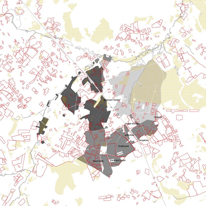
tions processes linked to the large estate was initiated for   of those situations and explores the type of urbaniza-
Brussels or Antwerp (Babar, 2015; May, 2018; Wambecq,          tion produced after some large noble land holdings in
2019; Zitouni, 2010). The specific contribution of our re-     Rixensart were dismantled. While leaving the unbuilt do-
search concerns the urbanization processes of estate ur-       mains for further development, we will focus on built es-
banization in the territory of Walloon Brabant.                tates and their progressive urbanization.
    In continuity with this corpus, we investigate Walloon          From this overview, we formulate hypotheses and
Brabant territory as historically comprised of large do-       preliminary questions. Does the size of these landhold-
mains and landholdings that belonged to the nobility and       ings generate a different form of urbanization? If urban-
aristocracy, the clerical order, and the Church or indus-      ization has not been underpinned by an emancipatory
trial and bourgeois landlords. Large landholdings or es-       political will to grant ownership access to middle-class
tate operations are examined to determine which con-           households but is rather the result of reproduction pro-
stitutive role they played in metropolization processes in     cesses driven by a social group or economic force, can we
the production of the spatial and material conditions of       identify the intermediate actors and their role? If urban-
urbanization. Building on cases of these estates’ trans-       ization occurred by dividing an area via one consistent
formation, we aim to explore the production of urban-          operation, as opposed to a parcel by parcel fragmenta-
ization in Walloon Brabant for a specific spatial configu-     tion, what were the necessary elements of negotiation
ration. Among the cases, we encounter a variety of situ-       between actors of urbanization (landlords, buyers, mu-
ations: allotment, businesses, industrial areas, and pre-      nicipalities, provinces) and did they define the material
served green elements such as forest, golf courses, etc.       conditions of such urbanization? Then, within the spe-
(see Figure 1 and Table 1). This article highlights one        cific spatial condition of dispersion mentioned above, to

Figure 1. Selection of former noble large land holdings in Walloon Brabant, square of 20 × 20 km. Drawing by the au-
thor based on Popp [ca. 1854], Meuwissen (1994), the lotissements dataset (SPW-DG04, 2020) and the orthophotoplan
(SPW-DG04, 2018).

Urban Planning, 2020, Volume 5, Issue 2, Pages 116–131                                                               117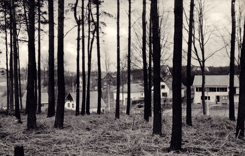
Table 1. Selection of former noble large land holdings in Walloon Brabant and their urbanization.
Large estate localization            Urbanization                                      Continuous or fragmented
Wavre Nord/Bawette domain            Urbanized: economic activities and tertiary       Continuous: golf
                                     area, golf course                                 Fragmented: activities
Rixensart/de Merode ownership        Urbanized: residential allotments                 Continuous: wood
                                     Not urbanized: Bois de Rixensart                  Fragmented: residential allotments
Louvain-La-Neuve/D’Hoogvorst         Urbanized: new town                               Fragmented: mixed functions
ownership
Waterloo/Battlefield Waterloo        Not urbanized: Battlefield of Waterloo            Continuous: tenant farming
Villers/Abbey                        Urbanized: abbey                                  Continuous: agricultural lands
                                     Not urbanized: agricultural fields
La Hulpe/Domaine Solvay              Urbanized: La Hulpe Park and pharmaceutical       Continuous: park
                                     industries                                        Fragmented: industries

what extent do these large landownership urbanizations             a construction resulting from the actions of its inhabi-
articulate themselves either to a metropolitan figure or           tants and their power relations. Large estates were most
to the one of a city territory?                                    often owned by dominant groups such as the nobility,
                                                                   ancien régime clergy, followed by bourgeoisie and cap-
2. Land Ownership and Its Influence on Urbanization                italist forces. Their construction or dismantling are the
                                                                   signs of social changes through economic mechanisms
Land ownership and its parcel division is taken as the van-        and negotiations between various actors in a society.
tage point to describe the urbanization of this part of            Within the urban development of the metropolis, these
the Brabant. Why ownership? The history of urbanism                signs also highlight conservation, speculation or migra-
and urbanization in Belgium is strongly linked to private          tion between the so-called center and periphery.
ownership policies and the development of specific imag-                We investigate estate urbanization on a regional scale
inaries around the ideal figure of the owner. Already dur-         within the frame of a city-territory (Piccinato, Quilici, &
ing the Industrial Revolution, the 1889 owner-worker’s             Tafuri, 1962). The village of Rixensart is the context of a
law proposed an incentive system for workers to become             large series of these land ownership transformations. As
owners in rural areas (Grosjean, 2010; Mougenot, 1999;             for a dense city such as Brussels, the landholdings’ recon-
Smets, 1977). After World War II, new policies for home            figurations occur through incremental processes (Babar,
ownership were supported by De Taeye Law of 1948, il-              2015) and lead to negotiated planning (Zitouni, 2010).
lustrated in Smets (1986), which describes the consump-            The description of the social geography helps to qualify
tive context of the Golden Sixties (les trentes glorieuses).       the material condition resulting from this urbanization
Meanwhile, land or home ownership and the liberal con-             process. In Rixensart, the de Merode family’s landhold-
struction of society based on non-selective private and            ings will serve to describe a palimpsest of urbanization
individual initiatives supported by selective national in-         through relations between actors and land processes.
frastructure policies are the core of the Belgian narrative
of urbanization (Dehaene, 2013).                                   3. Building the Unbuilt Patrimonial Estates: The Case
     The study of property is particularly rich owing to           of Rixensart
the latter’s complex and polysemous aspects (Bernard,
2017; Vanuxem, 2018). Property, as a bundle of rights,             Rixensart, a former village and now a municipality in
combines several understandings linked to the plural               Walloon Brabant, is located on the southern outskirts
realm of its definition: as land (relation to soil, its use        of the Brussels metropolitan region, in a continually
and value), as a social item (relation to owners, social           urbanizing area serviced by the trains of the Brussels
groups and their regulation by law), as a morphologi-              Regional Express Network. The Walloon Brabant is of-
cal element (plot, matrix and forms, their permanence              ten described as a peripheral region of Brussels, home
and transformation), and as a territorial system (terri-           to a wealthy population who wanted to escape the
torial domination of social groups, possession and ac-             metropolis. Originally constructed upon the rural and
cumulation). This polysemous meaning led us to read                light industrial structures belonging to a fiefdom of
ownership and its transformation in an urban manner.               several noble, aristocratic, and bourgeois landowner
Alongside the history of properties, one can read the his-         families (Hanin, 2004; Meuwissen, 1994), the Walloon
tory of ownership, unveiling societal relations and the            Brabant is currently experiencing intensifying processes
balance of power between social groups. The territory              of metropolization and their direct and collateral effects:
is then investigated as a societal product (Corboz, 1983),         rising real estate values, construction of new mobility

Urban Planning, 2020, Volume 5, Issue 2, Pages 116–131                                                                    118
infrastructure and congestion of existing ones, pressure        family, who owned much of the village and governed it
on and disappearance of farmland, and spatial inequity          via a mainly Catholic dynasty of Bourgmestre-Régisseurs
(Halleux, 2013; Hanin, 2012).                                   (mayor/estate-stewards). Instituting a concordance of
                                                                private land ownership and public governance in the mu-
3.1. Area South of Brussels                                     nicipality, they strictly controlled land use and therefore
                                                                society. Thus, Rixensart’s case reveals strong links be-
The Walloon municipalities to the south of the Brussels         tween nobility, industrialization, municipalism, and land
Region have long been a typical example (Grosjean, 2010;        ownership structure modifications.
Hanin, 2012; Puissant, 1997; Seebohm Rowntree, 1910;                 As a consequence of inheritance, de Merode lands
Vandervelde, 1900). Indeed, processes of urbanization           were divided among several family members. After Félix
in Rixensart were described when Emile Vandervelde              de Merode’s death in 1943, each of nine heirs inherited
(1900) selected it as a study case of the growing influ-        part of the whole. It was the first time the family’s land
ence of Brussels on the Brabant Region (see Figure 2).          was clearly divided and, while some holdings had already
While covering thoroughly land ownership in Belgium             been sold in the early 20th century, they now began
and Brabant with sharp datasets, Vandervelde showed             selling more of it, especially in the 1960s. All in all, de
two parallel trends driven by capitalistic forces: the frag-    Merode property, a combined 537 hectares that repre-
mentation of property and the reinforcement of large            sented two-thirds of the municipality in 1834, were re-
landholdings. Indeed, the development of railway infras-        duced to 128 hectares by the 2000s (Meuwissen, 2016).
tructure caused speculation on the land for the growing         In Section 5, we will investigate relations between sellers
metropolis of Brussels. Furthermore, southeast Brussels         and buyers and the property’s rearrangement.
is historically linked to the territories of owners who in-
habited villages and properties near the Sonian Forest          3.3. Production of Urbanization
and its former lumber yards, comprised mainly of nobles
and clerical groups (Génicot, 1973; Hasquin, 1976).             De Merode’s land division occurs after the De Taeye
                                                                Law of 1948, one of the most important post-war re-
3.2. Land Ownership and Governance                              building and housing policies. At individual and private
                                                                level, it provided incentives and subsidies to encourage
In the 18th century, Rixensart was the fief of a branch of      private construction among the low-income population.
de Merode’s family (the Felix de Merode branch), a his-         Mortgage loans were made mostly through loan compa-
toric family of Belgian nobility. After the ancien régime       nies such as Caisse Générale d’Épargne et de Retraite
during the 19th and 20th centuries, the municipality re-        and the Société Nationale des Habitations à Bon Marché.
mained under the strong influence of the de Merode              The law is regarded as a Catholic government effort to

Figure 2. De Merode’s properties in Rixensart municipality (gray areas). Source: Vandervelde (1900).

Urban Planning, 2020, Volume 5, Issue 2, Pages 116–131                                                                 119
keep village populations close to churches (Smets, 1985; fulfilled almost by default the role of more systemic plans
Theunis, 2007). or urban policies that were not yet elaborated. Most de-
The period coincides with the socio-economic con- cisions were municipal, supervised by provincial or re-
text of the Golden Sixties and the implementation of gional authorities, since permit authorizations were de-
the modern planning policy in the law of 29 May 1962, livered, except in specific cases, under the municipality’s
which is the founding basis of institutionalized urban responsibility after considering the advice of a regional
planning as we mostly still know it, dedicating areas to delegated agent known as le fonctionnaire délégué (pre-
specific land use under a strong functionalist assump- figuring the balance of power between municipality and
tion (Grulois, 2011). This resulted in a crucial moment in region in Belgian urban planning). Administrative permit
Rixensart’s urbanization: the building of most of its cur- documents help us to deepen the analysis and set up
rent urban structure and material condition. Indeed, a a grid, although allotment plans control some limited
large amount of the buildable parcels were then subdi- parameters: plot dimensions, setback distances, align-
vided through allotment permit, a procedure defined in ments, façade cladding and roof coverings, trees, and
the 1962 law, creating large residential areas available plantations, and in some cases density. Regarding the
for upper and middle-class populations. Various allot- quantitative output the permits dealt with, we find few
ments south of the municipality are paradigmatic of this limitations or constraints driven by more collective, eco-
process, congruent with de Merode landholdings close logical or political rationalities.
to the train station and not far from the highway, in close
relation with the growing Brussel metropolis. Whether 4. Mapping the Estates: A Descriptive Analysis
Rixensart is a combination and specific result of both con-
jectural laws remains to be verified, since De Taeye’s op- Among the domains that were sold, we limited our ex-
erational scale acts at an individual level. We rather insist amination to seven allotments on former noble landhold-
here on larger allotment operations and more liberal so- ings in Rixensart, chosen for their large size and period of
called uncontrolled estate operations. Nevertheless, we development: Léopold and Blanc Champ Avenues, Clos
will see that municipal and regional administrations pro- de la Mare au Loup, Albertine and Churchill Avenues,
ceeded quite consciously to produce urbanization. the Froidmont Farm neighborhood (Winterberg Avenue),
Hauts-Taillis Avenue, and Fond Marie Monseu (Figure 4).
3.4. Urbanistic Regulations Popp’s [ca. 1854] map and cadastral matrix, the first cov-
ering systematically the Belgian territory (in 1861 for
One hypothesis is that urbanistic policies were very per- Rixensart; see Vrielinck, 2018), were used to identify
missive during the first years of their implementation de Merode properties. Today, allotment permits are col-
(Laconte, 2012). Furthermore, some of the sales and lected in a GIS layer by the Service Public de Wallonie.
trading operations occurred before urban planning and Original plans, allotment permits, and legal prescriptions
planning tools emerged and became institutionalized in are accessible for each perimeter. More than a cen-
Belgium—land use plans that were announced in the tury separates the two maps, but the unaltered struc-
1962 law were only operational in the 1980s. In the ture of ownership until the first half of the 20th cen-
meantime, allotment and building permits (see Figure 3) tury (Meuwissen, 2016) allows us to proceed with this
Figure 3. Example of a Rixensart allotment plan, Albertine, 1962. Source: Service Public de Wallonie, Lotissements
(SPW-DG04, 2020).
Urban Planning, 2020, Volume 5, Issue 2, Pages 116–131 120Figure 4. Cadastral map of Rixensart in 1854 with overlapping of allotments permit in 2019, de Merode properties. Dark
gray areas represent the property of de Montalembert; gray areas, the property of Albertine de Merode; light grays, the
property of Frédéric de Merode; red perimeters represent subdivision permits; yellow dots, the forest areas. Drawing by
the author based on Popp [ca. 1854] and the lotissements dataset (SPW-DG04, 2020).
comparison. Table 2 lists the characteristics of the seven at the typo-morphological map of this area (Figure 5),
allotments. Allotment reference, date of authorization, more neighborhoods seem to be made up of separate vil-
owner, estate company (if any), parcel size, location, and las, even though they are not included within allotment
main prescriptions are indicated. Altogether, they repre- perimeters. An allotment permit is only needed when
sent 67.2 hectares. This superimposition of land struc- the owner wants to divide the land to subsequently sell
ture and the evolution of the cadaster following the it or build on it. Simple building permits are then not
subdivision permit allow a first level of reading of the included in the allotments’ dataset. Nevertheless, they
palimpsest (Corboz, 1993). could still be the result of a sale of de Merode’s land, par-
Almost exclusively residential, the allotments are cel per parcel, resulting from earlier subdivision.
comprised of villas and detached houses; most are single- Building these large landed properties in the 1960s
story and with occupied attic. Furthermore, if we look greatly impacted the construction of an urban realm in
Urban Planning, 2020, Volume 5, Issue 2, Pages 116–131 121Table 2. Selection of allotments in Rixensart.
Name Location Owner(s) Date # Ha. Estate cie. Geom./Arch. Delivering Authority Prescriptions
Léopold Avenue Léopold SA Matexi, 27–3–59 30 3.2 Matexi Ernest Crickx Delegated official Villas, bungalows, cottages.
Van Coppenolle (J. Wurth) Petrol pump or shop allowed
Avenue du on an angle
Blanc Champ
15 m or 20 m wide plots
(depending on situation)
Setback = 6 m, 3 m lateral
Limitation of felling trees
Fond Marie Avenue SA Matexi 16–7–62 55 5.3 Matexi Ernest Crickx Delegated official Villas, cottages, bungalows.
Monseu Marie-Christine, (L. Vanneste)
rue Froidmont H_cornice = 6 m, pitched roof
Setback = 6 m of which 2/3
are planted and 5 m lateral
20 m wide plot
Road 6 m + 2 × 2 m sidewalk
Building materials limited
Albertine Avenue Albertine, Marquise de 16–04–62 77 9 Beteor SA Achille Dupuis Delegated official Detached villas or bungalows.
Avenue Winston Clermont- Georges de Halloy (J. Wurth)
Churchill Tonnerre André Gallée H_cornice = 5 m
Rue de Limal Setback = 6 m minimum of
which 2/3 planted minimum
plot 20 × 15 m
Shop allowed on the angles
1.3 m mandatory sidewalk in
30 × 30 cm tiles
Urban Planning, 2020, Volume 5, Issue 2, Pages 116–131 122Table 2. (Cont.) Selection of allotments in Rixensart.
Name Location Owner(s) Date # Ha. Estate cie. Geom./Arch. Delivering Authority Prescriptions
Froidmont Avenue de Chevalier J. 24–5–68 273 30 / Achille Dupuis Permit refused by the Villa or bungalow, single family
Winterberg Demeure, Georges de Halloy municipality to preserve house, max 200 m2
et indivision André Gallée agricultural land, based
(Ferme de Baron Dubost on the opinion of the 1 lot (266) reserved for a shop.
Froidmont) delegated official
Christian Delacroix 252/FL/27. Setback = 6 m of which 2/3
Christian Demeure are planted
Edouard Demeure Legal recourse and
permit issuance by the H_Cornice = 5.5 m (manuscript
permanent deputation crossed out and replaced by 3.5 m)
of the province which
defines the area without mandatory sidewalk 30 × 30 cm tile
agricultural quality
(supported by agronomist Utilities networks at the expense
report) and of little of the purchasers, + maintenance
economic importance. It is of the roads during the works
nevertheless asked to
preserve the rural character
Plateau Avenue des D. de Lannoy, 19–6–64 74 6.4 / Henri Souka permit delivered by Single family house with
des Aubébines, M. de Lannoy, the municipality De Taeye Law requirement
Bruyères Paola, Fond P. Gillet (c/o (min 60 m2 )
Marie Monseu Cte Delannoy) + opinion of
delegated official Setback = 6m of which 1/2 are
(L. Vanneste) planted and 5m lateral
Limitation of felling of trees
Urban Planning, 2020, Volume 5, Issue 2, Pages 116–131 123Table 2. (Cont.) Selection of allotments in Rixensart.
Name Location Owner(s) Date # Ha. Estate cie. Geom./Arch. Delivering Authority Prescriptions
Mare au Clos de la Mare Demeure André 16–5–89 38 9.7 Foncière de Georges de Halloy permit delivered by Single family house
Loup au Loup, Foncière de développement SA. Leleux, C. the municipality,
Avenue Boulogne, développement SA. asking to change Pitched roof
Rue du Monastère some road
configurations Setback = 6 m, 3 m lateral
Building materials limited
Area covered by a schema
directeur PPA, indicating density
and contiguity requirements and
road/path network
Haut taillis Avenue de Dumont de 7–7–69 19 3.6 B.C.I. sprl BCI (?) permit delivered by Single family house (max 250 m2 )
Villefranche, Chassart the municipality
Avenue des Setback = 6 m of which 1/2 are
Hauts Taillis + opinion of planted and 5 m lateral
delegated official
(R. Beckers) Limitation of felling of trees
Building materials limited
Urban Planning, 2020, Volume 5, Issue 2, Pages 116–131 124Figure 5. Map of Rixensart 1960 (left) and 2010 (right). Built elements (black), forest (yellow dots), water (grey), and allot-
ments perimeter (red), municipal perimeter (dotted line). Elaborated by the author based on SPW-DG04 (2020).
Rixensart. The resulting urbanized patterns are mostly the selling of and building on each parcel may have been
residential, erasing almost any other type of use or func- a longer process, as shown by the variety of house styles,
tion (permits authorized some shops that were never some of which are very recent.
built), offering quite a different environment than the one In contrast, we should consider the preservation of
usually described for the nebulous Belgian city, resem- some parcels that were neither sold nor built on and may
bling rather a typical periurban urbanization (Figure 6). have been a form, intentionally or not, of ecological pro-
Nevertheless, under the apparent holistic process of tective measures. Mostly grouped around the de Merode
transformation of land inherent to the allotment process, Castle, some of the unbuilt plots are recognized as valu-
some territorial structures persist as traces in the pat- able natural areas such as Bois de Rixensart or Bois de
terns of the new development, remaining untouched as Merode. Behind the land use and land ownership struc-
remnants (of a farm or monastery), fragments or a ge- ture, several patrimonial, inheritance or economic deci-
ometrical feature in the landscape (path, rural pattern, sions led to the current spatial configuration and the pre-
tree alignment). If division was part of the allotment act, served areas today continue to be pressured.
Urban Planning, 2020, Volume 5, Issue 2, Pages 116–131 125Figure 6. Urbanization in the Winterberg Avenue in Rixensart. Photographs by the author.
5. Building the Material Condition of The City-Territory In the case of Rixensart, this sequence of modifica-
Urban Landscape tion implying multiple actors occurred in the 1960s and
1970s and created the material and spatial conditions
5.1. A Palimpsest of Actors of urbanization. In the following step, we highlight the
link between these actors and the material conditions of
To observe the urbanization produced on these large urbanization. Doing so, we relate the characteristics of
landholdings, we use the concept of the palimpsest men- the urbanization to the actors who took part in its con-
tioned above. In between the lines of the parcels, spaces struction voluntarily or not. Investigating these groups
of negotiation are recognizable and should be analyzed through a socio-spatial palimpsest clarifies what part of
as part of rethinking our territorialities (Corboz, 1983, the urbanization belongs to the specific and successive
1993). The concept of a palimpsest would not be of transformation of large landholdings.
particular interest if it did not highlight the transforma- Let us browse these different groups. Letters and
tion of urban society through changing land structures legal prescriptions attached to the subdivision permit
(Vanneste, 2018). Through the multiple reading levels of listed previously make it possible to draw a portrait of
the property concept (owner/ownership/property) and the negotiation or opposition within the transfer of prop-
the land structure, we emphasize the relationships be- erty and to what extent the delivering authority allows,
tween land situation, uses, and value, which allow us to refrains from or negotiates elements of the urbanization
look at the production of space as intertwined with the project. Which actors favored maintaining agricultural
agency of social and professional groups. Underneath land? Which private or public actors pushed for more
this space of negotiation, we describe the urbanization development and why? Who defined the dimension of
produced in the specific socio-economic and urban con- the plot, streets, the proportion of built and open space?
text of Walloon Brabant. Ultimately, by whom and how were the material condi-
Emphasizing the overlapping of actors involved is an tions of urbanization defined?
additional approach to the idea of a palimpsest, enabling
a territorialized vision of an urban society. In these pro- 5.2. Noble Estates
cesses of transfer of property, we scrutinize the actors’
constellation behind elements of negotiation to envision Nobility owned land that remained mostly unbuilt.
the material conditions that supported the production Estates were wooded and agricultural land. The succes-
of the urban landscape. Actors involved are witnesses of sive division through inheritance processes reduced the
territorial changes in the ownership structure abruptly size of de Merode land holdings but resulting plot size re-
shifting from one long established situation with large di- mained of large dimension. When sales started in the sec-
mensions’ family estates with patrimonial value to one ond half of the 20th century, the land structure inherited
at the scale of middle-class owners marking the emer- from the 19th century and their owners conditioned the
gence of large-scale land commodification. In the mid- dimension of the operation, enabling estate companies
dle is the real estate company, trading on the economic to buy, divide and sell quickly and consistently important
value of this ownership transfer. In this sense, this urban- pieces of land.
ization represents a discretized capital accumulation typi- Recalling de Merode’s strong influence on local gov-
cal of post-war growth and the possibility for the housing ernance and land ownership (through the estate stew-
market to absorb this surplus. This last palimpsest layer ard and mayor), this fragmentation of nobility owner-
largely overwrites the former ones but is also largely con- ship could denote a loss or shift of influence domain.
ditioned by them. Nevertheless, some parcels still belonged to the fam-
Urban Planning, 2020, Volume 5, Issue 2, Pages 116–131 126ily during the 1960s and most owner names still re- and setback distances, but also the grammar of roads
flected those of noble family members, who were prob- and house size and volume. Within the urbanization
ably the heirs and inheritors belonging to different de processes of these domains, decision-makers were in-
Merode branches. In 2019 a more distant branch of the deed crucial actors in the precise definition of an urban
original de Merode family reinvested in the Rixensart grammar. Municipality, Walloon Region, and Walloon
Castle and its domain for patrimonial and touristic rea- Brabant Province authorities and representatives had
sons by buying the castle of Rixensart (de Vogelaere, great decision-making responsibilities concerning parcel
2019). Therefore, large areas remain unbuilt, such as the urbanization, or at least the type of product and urban
Rixensart woods. fabric. When allotments were distributed, one of the
representatives was Léopold Gilson, mayor from 1952
5.3. Sales Operations, Administration, and Urban to 1970 and the last estate steward of the de Merode
Grammar family, meaning the person in charge of managing the
family’s assets and estates.
Sales operations involved a set of professional and pri-
vate actors. Geometers, architects, resellers, and estate 5.4. Territorial Base and Natural Features
companies were to draw and conceive allotment plans
for the municipal and provincial administration to ana- Unbuilt properties were mostly wooded or agricultural
lyze and authorize. Real estate companies were often areas. One can see in analyzing the permit document
present as operating actors in the process of dividing, sell- that the neighborhood’s character was discussed in an
ing, and building on the land. In two cases, the company attempt to maintain a rural look and existing vege-
itself was already the owner of the parcel in the permit tation. Among the allotment dossiers, the agricultural
document, implying that the parcel was sold in an earlier value of the Winterberg Avenue allotments around the
transaction, maybe not directly by the de Merode family. Froidmont Farm was a defense against the act of building
What were the benefits of or the need for creating (Figure 7). In 1962, the permit was refused by the munic-
such companies? Couldn’t the noble’s family have sold ipality on the advice of the regional functionary, on the
themselves the land? Estate companies probably eased ground of defending valuable agricultural land and the
the management of repetitive and massive operations landscape’s rural character. To oppose the decision, the
and outsourced a technical service. Incidentally, mem- owner went to a higher court, at the provincial level. The
bers of the nobility were still involved in the real es- province delivered the permit against the municipal de-
tate companies, as reflected in allotment permit forms. cision, lessening the value of the agricultural land based
Furthermore, they could help in inheritance procedures on an agronomist’s report, but, ironically, still asked the
or just personify an economical tool to multiply subdivi- owner to maintain a rural character in the project’s devel-
sion operation, given we found companies involved on opment. The case anticipates the problem of agricultural
different allotment sites. land consumption by urbanization, which today is a fun-
It was, however, not an innocuous operation. damental element of the European debate over ‘no net
Resellers’ financial interest and modern land use policy land take,’ aiming to reduce oversized residential areas
defined not only the plot’s dimensions and repeatability of zoning plans.
Figure 7. Neighborhoods of the Froidmont Farm in Rixensart. First houses under construction on Avenir Avenue, picture
of H. Pilmeyer around 1954. Source: de Séjournet (2020a).
Urban Planning, 2020, Volume 5, Issue 2, Pages 116–131 127Another key element in the prescriptions accompany- periurban landscapes. Some nuance is required to under-
ing the building permit is the conservation of trees or lim- stand the operation’s time span. While the transfer of
iting of tree felling. Indeed, in all the other cases, some properties and allotments of land ownership took place
previous natural or landscaped features, such as trees over a few decades, house construction reveals that the
and onsite vegetation, are the subject of preservation re- progressive development of the plots spans from the di-
quests as well, in whole or in part. Most of the sold land vision of the land until today; some houses were still un-
was wooded, part of former de Merode domains and der construction in the 2000s. This prolonged period of
remnants of the Sonian Forest. All legal prescriptions in- construction gives the urbanization a heteroclite appear-
cluded preservation of wooded areas. If the documents ance: each house represents the aesthetics or building
provide no reason for it, one can assume the reasons are standards of its time.
the trees’ ecological value but also their symbolic value Another recurrent regulatory requirement of the sub-
as being linked to the area’s noble roots, conferring on division permits is plot dimensions, including setback dis-
certain parts of the neighborhood aspects of inhabited tances. Surprisingly, setback distance is very consistent,
forest (Figure 8). six meters from the street, five to three meters from
The defense of agrarian and natural characteristics, neighbors. Inner roads of the allotment are the devel-
even in a sterile or picturesque manner, emphasizes a oper’s responsibility, then retroceded to the municipal-
certain idea of living in an open landscape and foreshad- ity. Quite often, the plot’s buyer and future owner are
ows more ecological topics. The opposition between the responsible for the sidewalk, therefore taking part in re-
institutional actors such as the province, the commune, sponsibility for road infrastructure. Some basic compen-
and the regional functionary should be explored to un- sation mechanisms force the developer to dedicate a
derstand each party’s interests and if specific themes small part of the area to green spaces or playgrounds.
were defended or opposed regularly. While setback distance allowed in latter phases for house
additions or a backyard for each inhabitant, it is also
5.5. Middle Class and Suburban Imaginaries a space of ambiguity, without real contiguity between
neighbors kept at a distance and behind a green curtain
Middle class families inhabited these new allotments, of plants. The ambivalent permit requirement of urban-
buying or building mainly single-family houses from the istic responsibility for the sidewalk constitutes equally a
developer, being the end of line in the selling process we collective effort in the construction of the infrastructure
are describing. This generation embodied a way of life as well as an absence of collectiveness, each inhabitant
based on individual social and economic achievement taking care of his or her own front space.
embodied in the image of suburban villas. Through their Ultimately, this in-between space creates an open
purchase, they anchored Golden Sixties capital values in and low-density fabric associated with garden cities,
Figure 8. Wooded land built on through an allotment process. Avenue Joséphine-Charlotte, picture from the J.-L. Lebrun
collection. Source: de Séjournet, E. (2020b).
Urban Planning, 2020, Volume 5, Issue 2, Pages 116–131 128which were preeminent in a primary phase of modern de- absence of preservation or strong defense of natural or
velopment in Belgium; even though it ceased after a few ecological land is also a lack of a collective dimension.
experiments, the movement left an important imprint The case of Rixensart reflects strong links between
on housing imaginaries in Belgium (Smets, 1977, 1986). nobility, industry, municipalism, and land ownership
All in all, the urban fabric is characterized by a ‘setback structures. The original approach to reading these rela-
urbanization,’ either physically by distancing the build- tionships through a geography of actors offers a new
ing, or conceptually by placing elements of infrastructure perspective on recent forms of Walloon Brabant urban-
such as sidewalks or green areas under the responsibility ization in a Belgian city-territory context. Indeed, the
of the individual rather than the collectivity. case reveals a period of strong municipal governance dur-
ing which planning tools were very recent, permissive,
6. Conclusion and only in some cases opposed by higher authorities.
We find the involvement of private entrepreneurship, as
Mapping the transformation of large domains and described in dispersed city conditions, but here on the
landed properties in Rixensart reveals dynamics of urban- broader scale of the allotments, with the involvement
ization produced in a coherent socio-economic period of of developers and estate companies. Thus, not only the
growth, on a territorial scale, in strong relation with the planning tools and administrative machine but also the
metropolization of Brussels. Timewise, the study case un- private sales of powerful territorial actors form a web of
folded during a specific moment of post-war urbaniza- relationships. In this sense, large domains are the recep-
tion. Through the case of Rixensart we arrived at sev- tacles of post-war socio-economic dynamics and national
eral findings addressing four main issues: metropoliza- growth, which find an easy outlet in quickly accumulated
tion on preexisting conditions, forms of urbanization land capital and lead to an urban morphological pattern
(large dimensions with little collective arrangements), of greater urbanization.
the relationships between actors (entrepreneurship and Furthermore, under the socio-spatial palimpsest of
administration machine), and the regional condition of the Rixensart case, we uncovered a territorial condition
land ownership. of Walloon Brabant urbanization that proved to be re-
First, we argued that de Merode land subdivision lated to large land ownership. This landed structure and
processes—and, by generalization, large domains inher- availability of buildable land is strongly linked to the for-
ited from former feudal noble structures—had gener- mer power structure of ancien régime noble families—
ated another type of urbanization when entering the and later of the industrial bourgeoisie. Several Walloon
buildable land market: not incremental, fragmented Brabant municipalities present a configuration similar to
and mixed as predominantly observed in the industrial Rixensart’s, where the permanence of land ownership
phases of urbanization that usually defines Belgium’s dis- and a genealogy of political management of the mu-
persed urbanization, but rather large, functionalist, and nicipality coincide (Goblet d’Alviella and Boël in Court-
homogeneous, which is typical of periurban metropoli- Saint-Etienne, Vanderlinden d’Hoogvoorst in Ottignies,
tan dynamics. The production of urbanization occurs on Solvay in la Hulpe, Cornet in Braine, etc.). As shown in
a larger scale than it did previously, although it still re- the introduction, not all of these lands resulted in peri-
lies on dispersed features of the rural and pre-industrial urban urbanization, but most were transformed during
territorial structure. In our case, the spatial configuration the 20th century whether they became golf courses, busi-
of the land ownership structure, embodied in the munic- ness parks, or residential areas.
ipality’s noble estates—relics of a fiefdom—and family Revealing the actors and their interrelation with
relationships with municipal decision-makers allowed ur- the urbanization of former estates brings a descriptive
banization to occur. knowledge about the production of this specific space.
Second, the large amount of available land made pos- Noble families, by owning large landholdings and sell-
sible the settlement of a middle-class generation and ing them in large tracts, intervene in the size of the
the construction of its suburban imaginary. It resulted in estate operation; discussion between estate companies
the production of a quite consistent urban fabric, drawn and administrations about land use, landscape, and plot
up by ‘setback urbanization’ where individual freedom is size defines the layout of the space; the middle-class
embodied by each individual’s plot but where, paradox- population inhabiting these urbanizations generate ar-
ical to the plot’s unifying morphology, no collective spa- chitectural styles and picturesque gardens. After the fine
tial dimension is fundamentally incorporated. It is strik- descriptive period of the 80s that described the hor-
ing to note the few but nevertheless existing nods to izontal and nebulous city, palimpsestic description to-
landscape or ecology in the urbanization process. Except day should testify to the complexity of city territory and
from the case mentioned above, where the emergence spur thought regarding the future processes between
of a conflict between buildable land value and natural metropolization and dispersion.
or geographical land value, opposing economic and eco-
logical value, is evident, the valorization of landscape or Conflict of Interests
natural features only occurs at the level of the parcel, in
each discretize and individual form. In another way, the The author declares no conflict of interests.
Urban Planning, 2020, Volume 5, Issue 2, Pages 116–131 129References horizontal metropolis between urbanism and urban-
ization (pp. 269–281). Cham: Springer.
Babar, L. (2015). Grande propriété foncière et développe- Génicot, L. (Ed.). (1973). Histoire de la Wallonie [History
ment urbain. Le cas bruxellois (XIXe–XXe siècle) of Wallonia]. Toulouse: Privat.
[Large land ownership and urban development. The Grosjean, B. (2010). Urbanisation sans urbanisme, une
Brussels case (19th–20th century)] (Unpublished histoire de la ville diffuse [Urbanization without ur-
Doctoral dissertation). Université Libre de Bruxelles, banism, a history of the diffuse city]. Liège: Mardaga.
Brussels, Belgium. Grulois, G. (2011). La construction épistémologique
Bernard, N. (2017). L’article 17: Le droit de propriété [Ar- de l’urbanisme en Belgique [The epistemological
ticle 17: The right of property]. In S. Van Drooghen- construction of town planning in Belgium]. Bel-
broeck & F. Picod (Eds.), Charte des droits fonda- geo, 2011(1/2), 5–16. https://doi.org/10.4000/
mentaux de l’Union européenne. Commentaire arti- belgeo.6329
cle par article [Charter of fundamental rights of the Halleux, J.-M. (2013). Le gaspillage wallon [The Walloon
European Union. Commentary article per article ] (pp. waste]. Les Cahiers Nouveaux, 85, 13–15.
369–391). Brussels: Bruylant. Hanin, Y. (2004). Mutations spatiales et recompositions
Corboz, A. (1983). Le territoire comme palimpseste [The territoriales. Les processus territoriaux dans le cas
land as palimpsest]. Diogène, 121, 14–35. de Court-Saint-Etienne [Spatial changes and territo-
Corboz, A. (Ed.). (1993). Atlas du territoire genevois. Per- rial recomposition. Territorial processes in the case of
manences et modifications cadastrales au XIXè et XXè Court-Saint-Etienne] (Unpublished Doctoral disserta-
siècles [Atlas of the Geneva territory. Permanences tion). UCLouvain, Louvain-la-Neuve, Belgium.
and cadastral modifications in the 19th and 20th cen- Hanin, Y. (2012). Habiter en Wallonie: Évolutions, ten-
turies]. Geneva: Département des travaux publics du dances et prévisions à l’horizon 2040 [Living in Wallo-
canton de Genève, Service des monuments et des nia: Developments, trends and forecasts up to 2040].
sites. Les Cahiers Nouveaux, 84, 82–84.
De Block, G. (2011). Infrastructuur als inzet voor de or- Hasquin, H. (1976). Histoire, économie, sociétés. Tome 2:
ganisatie van het territorium. Technologie, ruimte en De 1830 à nos jours [History, economy, societies. Vol-
maatschappij in België sinds het begin van de 19de ume 2: From 1830 to the present day]. In H. Hasquin
eeuw [Engineering the territory. Technology, space (Ed.), La Wallonie. Le pays et les hommes [Wallonia,
and society in 19th and 20th century Belgium] (Un- the land and the men] (Vol. 2, 1–529). Waterloo: La
published Doctoral dissertation). KU Leuven, Leuven, Renaissance du Livre.
Belgium. Indovina, F. (1990). La città diffusa [The diffuse city].
De Block, G., & Polasky, J. (2011). Light railways and Venice: Daest, Dipartimento di Analisi Economica e
the rural–urban continuum: Technology, space and Sociale del Territorio.
society in late nineteenth-century Belgium. Journal Laconte, P. (2012). La loi du 29 mars 1962 sur l’urbanisme
of Historical Geography, 37(3), 312–328. https://doi. et ses effets: Quelques réflexions [The law of 29
org/10.1016/j.jhg.2011.01.003 March 1962 on town planning and its effects: Some
De Meulder, B., Schreurs, J., Cock, A., & Notteboom, B. thoughts]. Les Cahiers Nouveaux, 82, 34–39.
(2009). Sleutelen aan het Belgische stadslandschap May, L. (2018). Suburban place-making: ‘Place distinc-
[Patching up the Belgian urban landscape]. Oase: Ti- tiveness’ as manifestation of political-economic coali-
jdschrift voor Architectuur, 52, 78–113. tions: Antwerp, ca. 1860–ca. 1940. Paper presented
de Vogelaere, J.-P. (2019). Le château de Rixensart reste at the “On reproduction: Re-imagining the political
dans les mains de la famille de Merode [The castle ecology of urbanism” Conference, Gent.
of Rixensart remains in the hands of the de Merode Meuwissen, E. (1994). Les grandes fortunes du Brabant.
family.; Press Release]. Retrieved from https://plus. Seigneurs de la terre, Capitaines d’industrie [The
lesoir.be/212215/article/2019-03-14/le-chateau- great fortunes of Brabant. Lords of the Earth, cap-
de-rixensart-reste-dans-les-mains-de-la-famille-de- tains of industry]. Ottignies: Quorum.
merode Meuwissen, E. (2016). Les Merode ou le syndrome de la
de Séjournet, E. (2020a). Froidmont, panoramique peau de chagrin à Rixensart [The Merode or the fad-
[Froidmont panoramic]. Retrorixensart. Retrieved ing to nothing syndrome at Rixensart]. Chroniques du
from retrorixensart.com cercle historique de Rixensart, 38.
de Séjournet, E. (2020b). Avenue Jospéhine-Charlotte Mougenot, C. (1999). La société nationale de la petite
[Joséphine-Charlotte avenue]. Retrorixensart. Re- propriété terrienne. Une institution entre ville et
trieved from retrorixensart.com campagne, entre tradition et modernization [The na-
Dehaene, M. (2013). Tuinieren in het Stedelijk Veld [Gar- tional society of small land ownership. An institution
dening in the urban field]. Gent: A&S Books. between town and country, between tradition and
Dehaene, M. (2018). Horizontal metropolis: Issues and modernization.]. Les Cahiers Nouveaux, 1999(25/26),
challenges of a new urban ecology statements. In P. 145–148.
Viganò, C. Cavalieri, & M. Barcelloni Corte (Eds.), The Peleman, D. (2013). “Les hommes de la route”: Engineer-
Urban Planning, 2020, Volume 5, Issue 2, Pages 116–131 130ing the urban society of the modern road in Belgium, SPW-DG04. (2018). Orthophotos 2018. Geo Por-
1889–1962. Ghent: Department of Architecture and tail. Retrieved from https://geoportail.wallonie.
Urban Planning. be/catalogue/71cb59f2-fb18-41bc-9dbf-
Piccinato, G., Quilici, V., & Tafuri, M. (1962). La città terri- 00ab93f69850.html
torio: Verso una nuova dimensione [The city territory: SPW-DG04. (2020). Lotissements (LOT). Geo Por-
Towards a new dimension]. Casabella, 270, 16–25. tail. Retrieved from http://geoportail.wallonie.
Popp, P.-C. [ca. 1854]. Atlas cadastral parcellaire de be/catalogue/4572f901-7d5e-4fe6-931e-
Belgique [Cadastral parcel atlas of Belgium; Map]. ac19c8fc04fe.html
Province de Brabant: Arrondissement de Bruxelles. Theunis, K. (2007). De zoektocht naar een Belgisch woon-
Canton de Bruxelles. KBR, Brussels, Belgium. Re- project, 1965–1975. Toenaderingen tussen ontwer-
trieved from https://opac.kbr.be/library/maps-and- pers en overheid in de praktijk van het private wonen
plans.aspx? [The search for a Belgian housing project, 1965–1975.
Puissant, J. (1997). L’industrialisation du Brabant wallon Approaches between designers and government in
et son impact sur l’urbanisation [The industrialisation the practice of private housing] (Unpublished Doc-
of Walloon Brabant and its impact on urbanisation]. toral dissertation). KU Leuven, Leuven, Belgium.
Les Dossiers Espace-Vie, 6, 35–42. Uyttenhove, P. (2011). Stadland België, hoofdstukken uit
Ryckewaert, M. (2011). Building the economic backbone de geschiedenis van de stedenbouw in België [Stad-
of the welfare state in Belgium. Infrastructure, plan- land Belgium, chapters in the history of urbanism in
ning and architecture 1945–1973. Rotterdam: 010 Belgium]. Gent: A&S Books.
Publishers. Vandervelde, E. (1900). La propriété foncière en Belgique
Secchi, B., & Viganò, P. (2012). La métropole horizon- [Land ownership in Belgium]. Paris: Schleicher Frères
tale. [The horizontal metropolis] In P. Dejemeppe & éditeurs.
B. Périlleux (Eds.), Bruxelles 2040, trois visions pour Vanneste, G. (2018). Territory between product and
une métropole [Brussels 2040, three visions for a project: Rethinking the limits. In P. Viganò, C. Cav-
metropolis] (pp. 29–45). Brussels: Éditions Région alieri, & M. Barcelloni Corte (Eds.), The horizon-
Bruxelles-Capitale. tal metropolis between urbanism and urbanization
Seebohm Rowntree, B. (1910). Land and labour. London: (p. 422). Cham: Springer.
Macmillan. Vanuxem, S. (2018). La propriété de la Terre [The owner-
Smets, M. (1977). L’avènement de la cité-jardin en ship of the land]. Marseille: Wildproject.
Belgique, histoire de l’habitat social en Belgique Vrielinck, S. (2018). Grootse Plannen. De Kadastrale At-
1830–1930 [The advent of the garden City in Belgium, las Van België Van P. C. Popp: Genese En Datering
history of social housing in Belgium 1830-1930]. Brus- (1840–1880) [Great plans. The cadastral atlas of Bel-
sels: Mardaga. gium by P. C. Popp: Genesis and dating (1840–1880)].
Smets, M. (1986). La Belgique ou la banlieue radieuse Amsterdam: Amsterdam University Press.
[Belgium, or the radiant suburbs]. In Paysages Wambecq, W. (2019). Forest urbanism in the dispersed
d’architectures [Landscapes of architectures] (pp. Flemish territory (Unpublished Doctoral dissertation).
33–35). Brussels: F. d. l’architecture. KU Leuven, Leuven, Belgium.
Smets, M. (Ed.). (1985). Resurgam. La reconstruction en Zitouni, B. (2010). Agglomérer! Une anatomie de
Belgique après 1914 [Resurgam. Reconstruction in l’extension bruxelloise (1828–1915) [Agglomerate!
Belgium after 1914]. Brussels: Crédit Communal de An anatomy of the Brussels extension (1828–1915)].
Belgique. Brussels: Brussels University Press.
About the Author
Guillaume Vanneste graduated as an Engineer Architect from the EPL UCLouvain in 2009, and a
Research and Teaching Assistant and PhD from LOCI–Faculty of Architecture, Architectural Engineer-
ing and Urban Planning at UCLouvain. His actual research explores the production of contemporary
city-territory landscape and land structure in the Belgian dispersed urbanization. Unfolding the case
of Brabant from the issue of land ownership and land structure helps deepening the understanding of
contemporary situation in urbanism.
Urban Planning, 2020, Volume 5, Issue 2, Pages 116–131 131You can also read