Leveraging lidar for offshore wind energy - Vaisala
←
→
Page content transcription
If your browser does not render page correctly, please read the page content below
Leveraging lidar for offshore wind energy
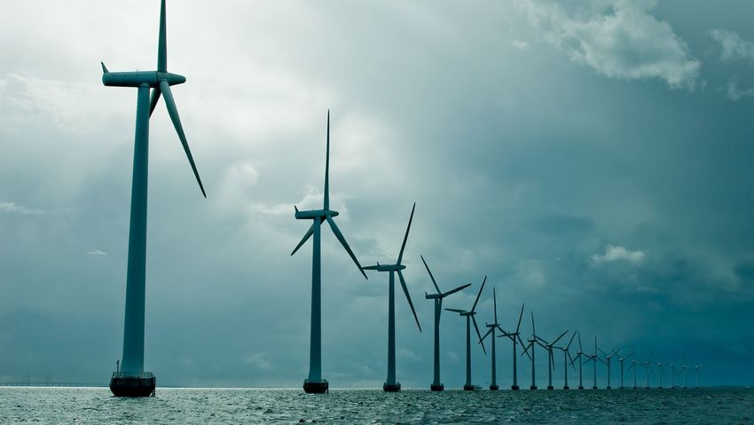
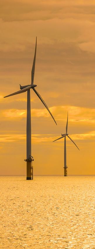
Around the world, offshore wind energy is              Offshore wind farms promise excellent wind availability
                                                       and energy capture, do not disrupt communities, and are
gaining speed. Growing interest and the project        immune to many common performance degradations that
                                                       come with complex terrain and onshore wind farm crowding.
pipeline in Europe, China, and other parts of the
                                                       They also bring a new set of challenges for wind
world are expected to contribute around 20% of         measurement that require new practices and technology,
                                                       including:
new installations by 2025 — impressive growth
compared to 2020 estimates. As the world’s largest     • Accurately assessing wind characteristics for very large
                                                         turbines and areas
regional offshore wind market, Europe is expected      • Obtaining precise wind data on the water, at long ranges
                                                         from the shoreline
to maintain steady growth. China is expected to        • Operating in harsh, salted environments far from
                                                         maintenance resources
continue dominating the Asian market challenged        These challenges are compounded by the fact that met
by such countries as Taiwan, Japan, and South Korea.   masts are often either impossible or prohibitively expensive
                                                       to deploy and maintain offshore. Even if a met mast is
The United States is entering the offshore wind        feasible, it cannot easily measure up to the full height of
                                                       today’s turbines.
market with developers planning to implement about
                                                       All of these factors have made new, reliable ways of
nine gigawatts (GW) of offshore wind by 2026.          assessing the wind even more critical for offshore projects.
                                                       Fortunately, remote sensing solutions are already proven,
                                                       trusted, and ready.

                                                                                                      © Vaisala 2021
Contents
     Offshore applications: Solution matrix                          4

     Offshore use cases and examples                                 5

        WRA: DNV GL                                                  5

             Floating lidar system validation with Akrocean          5

        WRA: Engie                                                   6

        Construction and commissioning: Siemens Gamesa               7

        Wind operations: SSE Renewables                              7

        Research and development: Centrale Nantes                    8

     Download the webinar                                            9

     The technologies                                              10

                                                              © Vaisala 2021
Offshore applications: Solution matrix
Lidar systems are comprehensive, compatible, and simple to deploy and repurpose throughout the life cycle of an offshore project. Because they are so easily
integrated, they can grow with you as your needs change.

                  Wind resource assessment /                       Construction /            Post-construction /                                          Post-construction /
 Lidar type
                       pre-construction                           commissioning                  operations                                                    research
                  Green   Platform    Nearshore     Farm        Craning        PPT -         Permanent      PPT during   Blocking     Wake losses   Wind farm wake       Turbine control   Wind farm     Short-term
                  field   available   situation     extension   Ship           Contractual   wind           operations   Effect       studies       effect               Cost reduction,   control       forecasting
                                      or platform   Impact of   operations     Power Curve   monitoring                  Understand   Understand    Impact of existing   AEP increase      Global        Monitor
                                      close to      existing    optimization                 Off-grid                    wind farm    production    wind farm on                           increase      upcoming wind
                                      island or     farms                                    compensation                layout       intra-farm    neighbors and                          of farm       minutes in
                                      lighthouse                                                                         impacting    losses        extension                              production    advance
                                                                                                                         wind ahead

Offshore –
buoy mounted
+vessels/ships/
floating drones
                   •
Offshore –
used fixed                   • •                                    •                            •
Nacelle-
mounted                                                                            •                            •                                                              •
Long-range
scanning                                 • •                                                                                 •            •                •                                    •             •

                                                                                                                                                                                                        © Vaisala 2021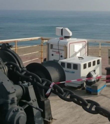
Offshore use cases and examples
Lidar is meeting many previously unmet needs for         As the world’s leading classification society, DNV                               Among their findings:
offshore developers and operators, and can also          GL is a recognized advisor for the maritime and
provide critical data for studying and implementing      other industries. The organization provides highly                               • Lidar was shown to provide better data and
wind farm extensions. Here are some of examples of       acclaimed testing, certification, and advisory services                            modelling with reduced uncertainty and risk
the most common and beneficial use cases for which       to the energy value chain.                                                       • Costs on average 80% less than met masts to
lidar is especially well-suited.                                                                                                            develop and deploy
                                                         DNV GL presented a detailed analysis in                                          • Achieves the best practice performance criteria
DNV GL: Analysis of lidar for WRA                        2020 to compare today’s most commonly used wind                                    set out by the Carbon Trust OWA Roadmap
                                                         measurement technologies: met masts, fixed lidar,
Wind resource assessment (WRA) is the make-or-           floating lidar systems (FLS), scanning lidar, and other                          AKROCEAN: FLS validation
break point for any wind farm project. Lidar supports    methods such as met buoys.
the challenges of WRA to prove wind availability and                                                                                      DNV GL completed an independent validation
characteristics, essential to ensure project viability   The organization focused their analysis on floating                              assessment of the WINDSEA floating lidar offshore
and return on investment. Lidars can facilitate          lidar technology by reviewing:                                                   wind measurement device on behalf of AKROCEAN,
offshore WRA in several ways including floating                                                                                           an organization providing services for offshore
lidar systems, offshore vertical profiling lidar, and    • The Carbon Trust Offshore Wind Accelerator                                     monitoring and site assessment*.
scanning lidar.                                            Floating Lidar Roadmap
                                                         • Sources of uncertainty and variability                                         From April to October of 2018, DNV GL completed
                                                           in determining bankable energy                                                 the validation process off the coast of France. During
                                                           production assessments                                                         this time, the FLS was subject to a wide range of
                                                         • Wind measurement uncertainty using an FLS                                      weather conditions and achieved an overall post-
                                                           uncertainty calculation framework (IEA RP18:                                   processed data availability above 95% at the 51m,
                                                           Floating Lidar Systems, 2017)                                                  91m, and 111m configured heights. The device also
                                                         • Current industry guidance from OWA, IEA, and IEC                               recorded wind speed and direction data with an
                                                                                                                                          accuracy in line with CT OWA Roadmap best practice
                                                                                                                                          acceptance criteria.

                                                         *DNV GL, “Validation of the WINDSEA_02 Floating LiDAR at the Fécamp offshore platform”, Ref. L2C149488-FRPR-R-01, Rev. C, 05 April 2019

                                                                                                                                                                                                   © Vaisala 2021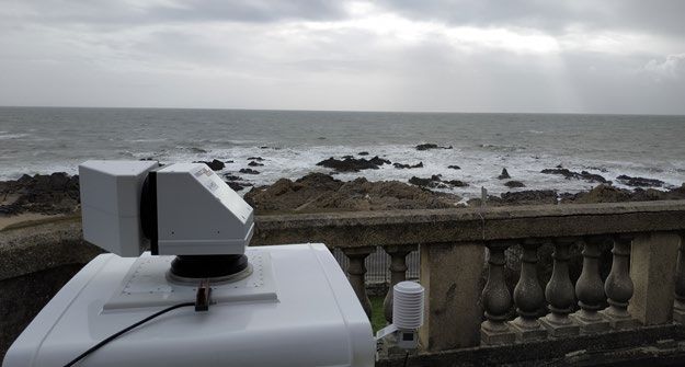
The results at these heights showed the verification    Engie: Validate wind modeling with                    The accuracy of wind models in offshore conditions
uncertainty levels of the unit ranged from 1.5% to      scanning lidar                                        are generally higher due to lack of appropriate
3.1% for wind speed bins from 4m/s to 16m/s. These                                                            parameterization schemes for resolving the land-
are important indicators for wind farm developers to:                                                         sea interaction effects. To assess the accuracy of
                                                                                                              the offshore models, Engie conducted a six-week
• Obtain an accurate estimation of the wind                                                                   campaign at one of their offshore wind farms off the
  resource at a potential offshore wind farm site                                                             coast of southern France.
• Reduce project uncertainty
• Achieve better financial conditions for                                                                     The campaign included two comparisons: scanning
  project realization                                                                                         lidar vs. mesoscale modeling and scanning lidar
                                                                                                              vs. vertical profiler. The experiment setup included
It also contributes to reduce the levelized cost of                                                           a scanning lidar on the coast to measure accurate
energy — important for helping to move the offshore                                                           wind speed and direction at multiple distances
wind industry forward.                                                                                        and heights above mean sea level, and a vertical
                                                                                                              profiler on the coast to correlate the measurements
                                                                                                              from offshore to onshore conditions, to assess the
                                                                                                              land-sea interaction effects. Profiles of wind speed
                                                                                                              measurements at 5km and 9km from the scanning
  First project of Akrocean in                                                                                lidar were assimilated to the offshore wind model to
  France after validation by                                                                                  reduce the bias and improve the overall assessment
  DNV GL:                                                                                                     of the Annual Energy Production (AEP) of the future
                                                                                                              wind farm.
  250 + 250MW floating project
  12NM from the coast                                                                                         Scanning lidar vs. mesoscale modeling findings:
  80 ~100m of depth
                                                        Engie is a manufacturer and integrator of renewable   • Discrepancies among sectors were significant:
                                                        energy solutions for wind, solar, and marine            relative error observed for southeast winds is
  Wind and Metocean studies and
                                                        applications. Based in France, the organization is      three times as much as northwest winds.
  public consultation launched by                       dedicated to advancing and digitalizing renewable     • Wind direction measured by the scanning lidar are
  French Energy Ministry in 2020                        energy and zero-carbon transition worldwide.            in line with mesoscale data at 5km 100m height.
  =>Tender 2021 (first 250 MW)                                                                                • The comparison between the scanning lidar and
                                                                                                                mesoscale data showed that it was possible to
                                                                                                                apply a correction factor to the mesoscale data
                                                                                                                using the scanning lidar as a reference.

                                                                                                                                                   © Vaisala 2021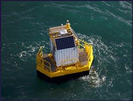
Scanning lidar vs. vertical profiler findings:            Lidar has many benefits over met masts, giving   SSE Renewables: Nacelle-mounted lidar
                                                          Siemens Gamesa several advantages as a top-      for operational PPT
• Both lidars were deployed on the deck of a cargo        tier manufacturer:
  boat standing by the sea. The scanning lidar was                                                         Lidar can replace a met mast on permanent
  initially configured in a DBS configuration for three   Overall benefits                                 wind farms to monitor performance and losses
  days to verify and compare the wind vertical                                                             when a turbine is stopped or the farm is off
  profile from 40m to 200m high.                          • Quick deployment with shorter campaigns        the grid. Nacelle-mounted lidar is ideal for
• The scanning lidar was first compared to a V1+          • Lower measurement campaign and                 crucial operational PPT campaigns where it can
  vertical profiler lidar system. The correlation           equipment costs                                quickly, easily, and affordably troubleshoot and
  between both systems was almost perfect (R² =           • Location flexibility                           identify underperformance.
  98,9%; slope = 1,0027).
                                                          Nacelle-mounted lidar
Siemens Gamesa: Construction
and commissioning                                         • Wider measurement sector without loss
                                                            of correlation provides faster power
Lidars are commonly used for different wind farm            curve calculations
development and operation applications such               • Reduces uncertainty by aligning with the
as craning and mounting operations, contractual             wind direction
power curve verification, and IEC-compliant PPT.          • Yaw error detection
One lidar unit can be used to conduct PPT for
multiple turbines.

As one of the world's biggest
wind turbine manufacturers,
Siemens Gamesa Renewable                                                                                   SSE Renewables is a leading developer and operator
Energy provides offshore and                                                                               of renewable energy across the UK and Ireland, with
onshore wind services and is                                                                               a portfolio that includes the largest offshore wind
well-known as a renewable                                                                                  development pipeline in the region. The organization
energy industry leader. For                                                                                works hard to keep the turbines running in
several years, the company has                                                                             top condition.
been using nacelle-mounted
lidar in place of met masts to                                                                             When they wanted to carry out some blade erosion
conduct PPT.                                                                                               repairs at one of the sites, SSE decided to run a
                                                                                                           PPT campaign to help determine the impact of the

                                                                                                                                                  © Vaisala 2021
blade repairs on turbine performance. The challenge     Central Nantes: Scanning lidar for R&D                    scanning lidar on the floating platform of a wind
was deciding which technology to use. SSE selected                                                                turbine, where it will analyze the wind resource
nacelle-mounted lidar to conduct their PPT campaign     With its real-time data, wind lidar is frequently being   and the wind turbine wake.
because of its ability to collect data over multiple    used to decrease uncertainties compared to statistical
heights and distances in front of the turbine,          models. Promising research and development                LHEEA deployed a long-range scanning lidar
straightforward installation and configuration, and     purposes now include wake loss and blockage effect        based on its high performance, reliability, and
far lower implementation costs.                         studies, short-term forecasting, and wind farm control.   remote access. The 360° spatial capabilities
                                                                                                                  of the lidar make it a leading instrument for
Nacelle-mounted lidar allows SSE to measure                                                                       wind analysis. Its versatility offers operational
multiple parameters, measure different ranges at                                                                  possibilities across research themes in the LHEEA
the same time, relocate the device to other locations                                                             laboratory, such as developing Marine Renewable
as needed, and conduct their own research projects.                                                               Energies and increasing knowledge of the
SSE plans to continue using the nacelle-mounted                                                                   atmospheric environment.
lidars on other wind farms and are already adding
one to another site. The combination of lidars will                                                               Scanning lidar is supporting several research
ensure efficient and reliable PPT and research                                                                    initiatives in the LHEEA laboratory, where its
projects long into the future.                                                                                    availability is quickly advancing the laboratory as
                                                                                                                  a major national player. It is an important lever in
                                                                                                                  establishing collaborative research programs and has
 “SSE recognizes the importance of                      Centrale Nantes is a French engineering school. Their     already led to the submission and launch of several
  understanding the performance of a wind               innovative Research Laboratory in Hydrodynamics,          national and international research collaborations.
  farm throughout its lifetime; PPTs are a              Energetics and Atmospheric Environment (LHEEA)
  key component of this and lidars are the              has 1km² of designated maritime zone dedicated
                                                        to measuring metocean conditions and hosting
  enabling technology.”                                 marine renewable energy prototypes, among which
                                                        is Floatgen — the first floating offshore wind turbine
  Andrew Davidson                                       (FOWT) in France.
  Wind Analyst at SSE
                                                        LHEEA sought lidar equipment to support two
                                                        important projects focused on optimizing
                                                        floating wind turbine operation and FOWT wake
                                                        unsteadiness. Their greatest challenge: put a

                                                                                                                                                       © Vaisala 2021
The technologies
WindCube®: Made for offshore
Leosphere, a Vaisala company's, WindCube lidar solutions are the most comprehensive set of offshore-ready measurement technologies in the world. There is a
WindCube solution to support nearly every part of an offshore project, from WRA, pre-construction, and contractual power curve testing to permanent wind monitoring,
research and development, and turbine testing and control.

 WindCube Offshore                                                     WindCube Scan                                                      WindCube Insights —
                                                                                                                                          Analytics
 Rugged and "marinized"                                                Industry-leading scanning
 offshore version                                                      lidar for 3D wind analysis at                                      Revolutionary software for
 • The reference lidar for all                                         long range                                                         WindCube Nacelle
    phases of wind energy          WindCube Nacelle                    • Reliably and affordably         WindCube Insights —              • Provides powerful, IEC-
    development and operations     Nacelle-mounted lidar for PPT           provides 3D wind mapping      Fleet                              compliant PPT and data
 • Can be placed on a fixed                                                and wake studies,                                                analysis and reporting
                                   and optimization                                                      Modern, cloud-based fleet
    platform or integrated into                                            indispensable to modern                                        • Enables developers,
                                   • Widely accepted for contractual                                     management software for
    a FLS                                                                  wind farms                                                       operators, and manufacturers
                                      and operational PPT, proven                                        WindCube lidar
 • Consistent, reliable and                                            • Fully configurable for                                             to easily conduct PPT and get
                                      to dramatically reduce                                             • Provides accurate and
    accurate data — wherever          operational costs while              several uses including 360°                                      more value from lidar and
                                                                                                           transparent system               turbine technologies
    you need it                       increasing efficiency                monitoring, atmospheric
                                                                                                           performance data               • Allows even smaller or
                                   • Up to 10x faster and                  cross-sectioning, and
                                                                                                           and reporting                    emerging wind energy
                                      provides 10x more data than          wind profiling
                                                                                                         • Allows users to monitor,         companies to conduct
                                      competing technologies           • Ideal for offshore
                                                                                                           assess, and manage their         affordable PPT at various
                                   • Unrivaled range from 50m to           measurement campaigns
                                      700m for a complete wind
                                                                                                           WindCube vertical profiling      points in the offshore
                                                                           conducted from the shore
                                      profile covering the rotor                                           lidar fleets                     life cycle
                                      sweep of even the largest                                          • Appropriate for all campaign
                                      offshore turbines                                                    types and fleet sizes

                                                                                                                                                           © Vaisala 2021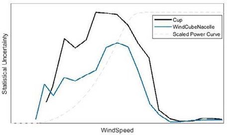
Why Leosphere, a Vaisala company?
We are modern innovators, scientists, and discoverers who enable our customers to harness the power of wind energy in new
ways. We are driven by passion, relentless curiosity, and the desire to create a better world, as evidenced in our commitment
to four guiding principles:

              Trustworthy, superior metrology
              Our solutions are backed by the best science and metrology, and validated by the most
              demanding testing and certifications in the industry. Our contributions make wind energy smarter.

              Unrivaled thought leadership
              Our years of experience, impressive global client roster, and plethora of industry breakthroughs
              demonstrate the we are the iconic gold standard in wind energy.

              Innovative lidars from a one-stop shop
              Customers know we have the right suite of solutions for their needs in wind energy — taking
              them ever higher by adding value at each step of the project lifecycle.

              Easy, reliable global solution
              We make our clients’ lives easier. Our easy to use, turnkey WindCube product suite enables
              customers to harness the power of wind energy efficiently and affordably.

As a result, Leosphere, a Vaisala company, is the iconic and trusted gold standard in wind lidar. Our turnkey WindCube product suite
offers innovative, reliable, and highly accurate solutions for thousands of customers across the globe. All of this has enabled us to
be catalysts for change and ambassadors for wind energy, always advancing the field and those we serve.

View the webinar "Leading with lidar; Solutions and strategies for offshore wind projects" to learn more.

windcubelidar.com

                                                                                                     Ref. DID64575EN-B ©Vaisala 2021
                                                                                                     This material is subject to copyright protection, with all copyrights retained by Vaisala and its individual
                                                                                                     partners. All rights reserved. Any logos and/or product names are trademarks of Vaisala or its
                                                                                                     individual partners. The reproduction, transfer, distribution or storage of information contained in this
                                                                                                     ebook in any form without the prior written consent of Vaisala is strictly prohibited. All specifications
                                                                                                     — technical included — are subject to change without notice.
You can also read