LINKS AVENUE SCHOOL TRAVEL SAFETY - A Safe System Review Colin Brodie | Hamish Mackie - Item 11.6 Links Avenue ...
←
→
Page content transcription
If your browser does not render page correctly, please read the page content below
LINKS AVENUE SCHOOL
    TRAVEL SAFETY
       A Safe System Review

    Colin Brodie | Hamish Mackie

            20 APRIL 2021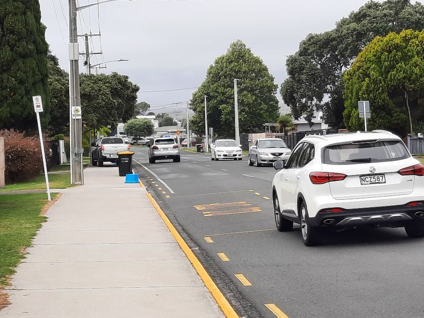
SUMMARY
This report provides an independent safe system review of safety concerns around the use of
the Links Avenue shared use path (SUP), particularly by school students. The review was based
on an afternoon and evening peak traffic site visit by Colin Brodie on 18 March, morning and
afternoon site visits by both authors on Monday 29 March (including incidental conversations
with members of the public on site), review of relevant documentation and meetings with
Tauranga City Council (TCC) staff to obtain further context.
Links Avenue is a busy pedestrian, cycling and bus route, particularly for school students from
three schools. However, traffic also rat-runs down Links Avenue to avoid congestion on
Maunganui Road in the AM peak, and to a lesser extent the PM peak.
Meanwhile, government’s strategic direction seeks to further support alternatives to private car
trips. A Vision Zero approach supported by central government and Tauranga City Council takes
the position that all deaths and serious injuries are unacceptable, and we need to be
accommodating of human error.
The core issue is that students walking and cycling on the shared use path along Links Avenue
between Golf Road and the Mt Maunganui Intermediate entrance often overflow onto the road
as they negotiate each other, street utilities and rubbish bins. At the same time there is very
little buffer space (around 0.9m) between the shared use path edge and the traffic lane edge
line. There have been reports of cyclists having near misses with buses and on our site visits we
witnessed behaviour that could be very risky if a bus or other vehicle happened to be passing.
Active travel is clearly very strong for the three schools served by Links Avenue and it should be
a safe and attractive option for students. The TCC school travel team has worked hard with the
local school communities to ensure this culture continues.
However, given the many interactions between traffic and pedestrians/cyclists, reports of
previous near misses and behaviour witnessed from our site visits, we believe there is a tangible
risk to pedestrians and cyclists using the SUP along the length of Links Avenue.
Given overall government direction, the alignment with the Vision Zero approach by Tauranga
City Council and hence the need to prioritise active and public transport trips, safe walking,
cycling, and bus travel should be prioritised at this location. There are various options that could
be implemented or tested, including removing the bus lane with or without re-routing buses.
However, one option that appears to have particular merit is the idea of testing a cul-de-sac
arrangement on Links Avenue for general traffic, allowing the bus lane to be removed, and for
buses, pedestrians, and cyclists only to access the north-western part of Links Avenue during
morning peak times. An interim measure could be a variable 20 or 30 km/h speed limit during
school times which may help to avoid or mitigate the most severe pedestrian or cycle crashes.

MACKIE RESEARCH & COLIN BRODIE CONSULTING | LINKS AVENUE SCHOOL TRAVEL SAFETY
                                                                                                     i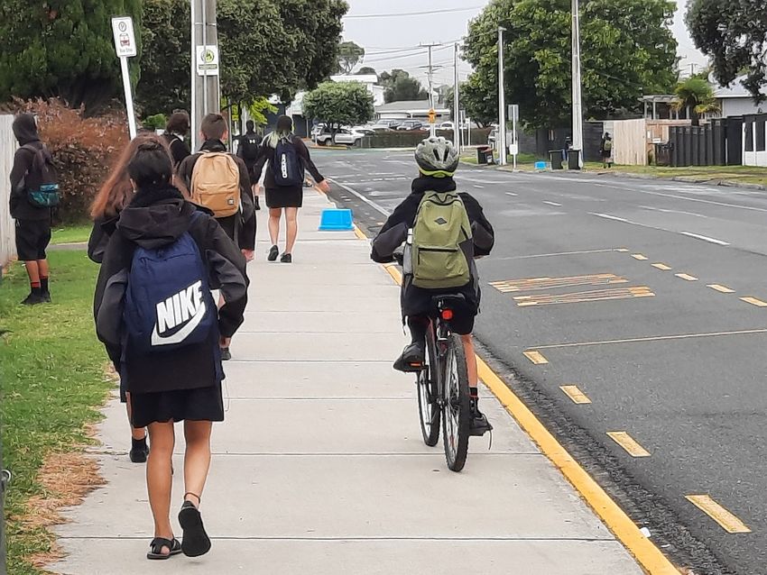
CONTENTS
SUMMARY ................................................................................................................................. i
1.    Background ....................................................................................................................... 1
       1.1.    About this report ........................................................................................................................................ 1
       1.2.    Safety concerns at Links Avenue, Mt Maunganui .................................................................................... 1
       1.3.    Links Avenue and the schools.................................................................................................................... 1
       1.4.    Network context ........................................................................................................................................ 2
       1.5.    Strategic context and the Safe System ..................................................................................................... 2
       1.6.    Road users .................................................................................................................................................. 3
       1.7.    Operating speed ......................................................................................................................................... 3
       1.8.    Crash history ............................................................................................................................................... 4

2.    The Safe System ................................................................................................................ 5
3.    Safe System review ............................................................................................................ 7
       3.1.    Road and pathway design .......................................................................................................................... 7
       3.2.    Network, traffic, and vehicles .................................................................................................................... 8
       3.3.    Pedestrians and cyclists ........................................................................................................................... 10
       3.4.    The overall nature, magnitude and likelihood of risks to road users using the Links Avenue shared
               use path .................................................................................................................................................... 12

4.    Analysis and considerations for future action ................................................................... 15
       4.1. Analysis ..................................................................................................................................................... 15
       4.2. Considerations for future action ............................................................................................................. 16

MACKIE RESEARCH & COLIN BRODIE CONSULTING | LINKS AVENUE SCHOOL TRAVEL SAFETY
                                                                                                                                                                             ii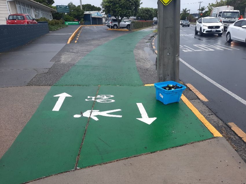
1. Background
1.1. About this report
This report provides an independent safe system review of safety concerns around the use of
the Links Avenue shared use path (SUP) by school students. The authors bring considerable
expertise in Vision Zero and the Safe System approach to road safety, school transport, and
human factors in transport systems and these areas of focus are the basis for the approach
taken and corresponding conclusions.
The review is based on afternoon and evening peak traffic site visit by Colin Brodie on 18 March
plus morning and afternoon site visits by both authors on Monday 29 March (including
incidental conversations with members of the public on site), review of relevant documentation
and meetings with Tauranga City Council staff to obtain further context.

1.2. Safety concerns at Links Avenue, Mt Maunganui
There is concern about the safety of school students using a shared path on Links Avenue (near
Mt Maunganui Intermediate). In 2019, a bus lane was added in the direction towards Golf Road,
which means a 10.5m wide road is accommodating three traffic lanes. This has led to minimal
separation between traffic and school students using the SUP. Recently, a student collided with
another cyclist, fell, and narrowly avoided a very serious incident with a passing bus and other
near misses of a similar nature have been reported.
Tauranga City Council has been investigating the issue and a range of possible solutions have
been suggested. However, given the recent incident and concern raised by the local community
and City Council, there is a need to further assess the safety risk to students and other road
users at this location. Based on this assessment, suggestions for action are also needed.

1.3. Links Avenue and the schools
Links Avenue is shown below in Figure 1. Mt Maunganui Intermediate has entrances on Links
Avenue, but importantly three school catchments (primary to secondary) use Links Avenue.
Links Avenue is an important walking, cycling, and public transport route for all three of these
schools, and students use this route at various times and sometimes in opposing directions.
Large groups of students travelling together and clustering around bus stops are common.

MACKIE RESEARCH & COLIN BRODIE CONSULTING | LINKS AVENUE SCHOOL TRAVEL SAFETY
                                                                                                   1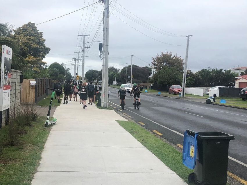
Omanu Primary School

                     Mt Maunganui College

                                  Mt Maunganui Intermediate

Figure 1. Links Avenue Location (Source: Google: Map data ©2021)

There is good accessibility to these schools and active mode share is very high with a high
proportion of students walking, skateboard, scootering and biking to all three schools. In a
previous study (Mackie 2009), cycling mode share was estimated at 20%, which is very high by
New Zealand standards. Over the years Tauranga City Council has worked hard to maintain
good relationships with schools and promote active travel. With the earlier two-lane
configuration with less traffic many students cycled on the road. Both this earlier work and our
current observations confirm that Links Avenue is an important component of the school
pedestrian and cycle network.

1.4. Network context
Links Avenue is also being used as a rat-run for traffic avoiding Maunganui Road en-route to the
city, particularly in the morning peak. A range of routes converge on Hewletts Road and when
Maunganui Road becomes congested traffic spills over onto Golf and Links Roads (from the
Bayfair direction). Links Road is classified as a primary collector road (using the One Network
Road Classification), but it is currently functioning as a proxy mixed use arterial road.
There is clearly a conflict between the traffic demands of Tauranga more widely and the safety
and well-being of school students and other active road users using Links Avenue.

1.5. Strategic context and the Safe System
A range of national and local strategy and policy documents should influence the approach
given to Links Avenue:

MACKIE RESEARCH & COLIN BRODIE CONSULTING | LINKS AVENUE SCHOOL TRAVEL SAFETY
                                                                                                   2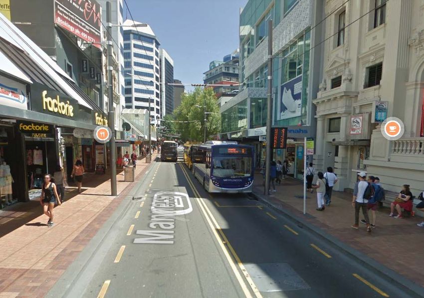
Government Policy Statement on Land Transport 2021/22-2030/31
There are four strategic priorities under the current Transport GPS: Safety, Better transport
options, Climate change, and Improving Freight Connections. Active and public transport are
key modes across these priorities. Accessing education through safe walking and cycling and
public transport is also an important theme in the GPS.
Road to Zero New Zealand’s Road Safety Strategy 2020-2030
Road to Zero takes the position that no death or serious injury on our roads is acceptable. There
is also a broader definition of well-being with both health and safety coming together. Related
to this the promotion of active modes and the requirement for those modes to be safe. The
vision and principles have been supported by 80-85% of New Zealanders 1.
Tauranga Street Design Guide, 2021
This guide outlines principles that underpin the development of streets and is strongly aligned
to the aspirations of the Tauranga Urban Strategy. A core emphasis is encouraging active travel
through street design and that everyone using our streets has the right to be and feel safe.
Tauranga City Council and Waka Kotahi NZ Transport Agency support a Vision Zero approach,
recognising that no death or serious injury on our roads is acceptable.

1.6. Road users
There are a range of road users routinely using Links Avenue:
Pedestrians and cyclists: Most commonly getting to and from school, but also adults travelling
to meet students, teachers accessing the schools and the general public walking, cycling and
getting to and from buses.
Bus users: In the morning peak we counted approximately 10 buses travelling towards Golf
Road on Links Avenue - a mix of city and school buses, with most bus passengers being school
students. In the afternoon school travel time, a greater number of buses predominantly
travelled south-eastward, with large numbers of students using both school and city buses. We
also noticed one inter-city bus in the morning peak, possibly avoiding congestion on Maunganui
Road. TCC data for August 2020 shows that there were 5,168 people boarding the bus on Links
Avenue.
General traffic: Vehicle traffic flows have grown from around 2000 vehicle per day (vpd) to over
5000 vpd over recent years, reportedly as a result of the congestion from the Bayfair to Baypark
(B2B) road works along the adjacent SH 2 and also general traffic growth in the Mt Maunganui
and Papamoa areas. In the morning peak, traffic queuing began at 7:30am and continued to
approximately 9am. Links Avenue is clearly a rat-run for travelling towards the city from the
Bayfair/Papamoa direction.

1.7. Operating speed
The overall operating speed for traffic on Links Avenue is 30-39 km/h (Waka Kotahi,
MegaMaps), however this is likely to be skewed by the morning congestion and other slow
vehicles entering and leaving driveways and intersections. A better speed metric for safety
purposes is 85% speed. Observing traffic speed on Links Avenue in the afternoon school time,

1
    www.transport.govt.nz/zero.

MACKIE RESEARCH & COLIN BRODIE CONSULTING | LINKS AVENUE SCHOOL TRAVEL SAFETY
                                                                                                  3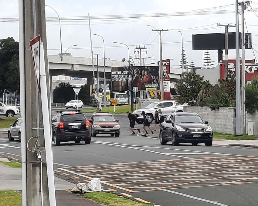
with much less congestion than the AM peak, 85% speed past the western end of the shared
path (near Golf Road) was estimated to range between 40-50 km/h. Measured speed tube data
was unavailable at the time of writing.

1.8. Crash history
Between 2011 and 2021 there have been seven reported pedestrian or cycle crashes on Links
Avenue, of which four occurred during school times. Although there is no crash history for the
risk described in this report, there has clearly been an incident involving a student falling from
their bike with their bike struck by a bus, as described by various accounts. Under-reporting in
the Crash Analysis System database is also well acknowledged, particularly for vulnerable road
user groups and so it is also useful to understand near misses and eye-witness accounts as
described, to understand the overall risk.

MACKIE RESEARCH & COLIN BRODIE CONSULTING | LINKS AVENUE SCHOOL TRAVEL SAFETY
                                                                                                     4
2. The Safe System
The Safe System underpins New Zealand’s Road to Zero Strategy, as it did with the previous
Safer Journeys Strategy, and a focus on roads, vehicles and road user choices continue to be key
focus areas along with system management and work-related road safety. Key principles that
must be considered in assessing road safety problems include:
    •   no loss of life is acceptable in the transport system
    •   deaths and serious injuries on our roads are preventable
    •   we all make mistakes, but these mistakes should not cost us our lives
    •   we design for human vulnerability
    •   our road safety actions support health, well-being and liveable places.
The four pillars of the Safe System, as shown by the earlier Safer Journeys’ interpretation, is
shown below in Figure 2, and these pillars are still important within Road to Zero.

Figure 2. The Safe System

Figure 3 below depicts how the traditional approach to road design deals with risk – users
needing to operate perfectly all the time to avoid serious injury or death, and not necessarily
being aware of level of risk that roads generate.

MACKIE RESEARCH & COLIN BRODIE CONSULTING | LINKS AVENUE SCHOOL TRAVEL SAFETY
                                                                                                  5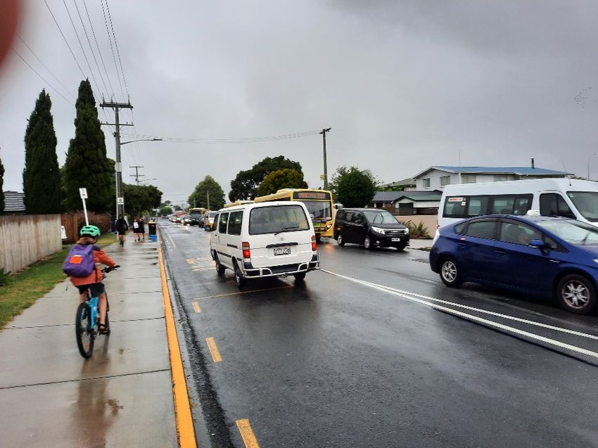
Figure 3. Pedestrian risk within the current transport system. Source: Vision Zero in Sweden, Lars Ekman.

However, human well-being should not be negotiable and should be a basic condition of any
road or transport context. As much as possible we must design roads and other system
elements so that they are user-friendly and accommodating of mistakes. And all of this should
be in the context of promoting active and public travel with the goal of developing liveable
communities.

MACKIE RESEARCH & COLIN BRODIE CONSULTING | LINKS AVENUE SCHOOL TRAVEL SAFETY
                                                                                                            6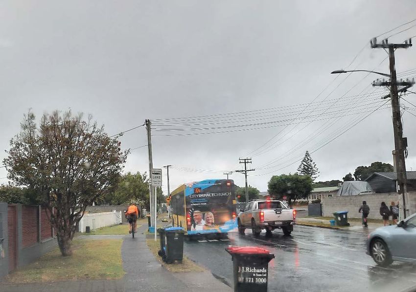
3. Safe System review
This Safe System review of Links Avenue has a specific focus on the safety of school students
walking and cycling, but also considers the safety and amenity for all road users. The review
considers the following areas:
    •    road and pathway design
    •    traffic and vehicles
    •    pedestrians, cyclists, and other micro mobility devices such as scooters
    •    the overall nature, magnitude, and likelihood of risks to school students
    •    considerations for future action.

3.1. Road and pathway design
The core issue of focus is the proximity of students using the shared use path (SUP) to passing
traffic on Links Avenue. The concern around this has developed since the introduction of a bus-
lane in 2019 where three traffic lanes are now squeezed into the existing corridor. The road
configuration is shown below in Figure 4, with associated dimensions. Although these widths
vary slightly along the corridor, and the usable space on the shared path is affected by rubbish
bins, power infrastructure and occasional parked vehicles, the configuration is relatively
consistent along its extent.

                                    3.2m           3.0m            3.4m

Figure 4. Links Avenue layout.

    •    Shared use path on the eastern side: 2.4m
    •    Distance between yellow line on SUP and white edge line on road: 0.9m
    •    Traffic lanes as shown (between lines)
    •    Kerb to kerb road width approx. 10.5m.

MACKIE RESEARCH & COLIN BRODIE CONSULTING | LINKS AVENUE SCHOOL TRAVEL SAFETY
                                                                                                   7
The configuration shown above extends between Golf Road and the Mt Maunganui School
entrance where road marking was added following a Safety Audit in 2019, to delineate priority
for pedestrians and cyclists on the SUP, and also to make the edge of the SUP more defined
using a painted yellow kerb (Figure 5) below.
Figure 5. Improved delineation at Mt Maunganui School entrance.
Further to the south-east on Links Avenue there is a greater buffer between the pathway and
the traffic lanes. The SUP pathway stops at Ascot Road about 55-60% of the way along Links
Avenue, as pedestrians and cyclists are encouraged to use link pathways on Ascot Road and
Berwick Place to reach Concord Avenue. However, our observations were that most students
did not use these links and instead chose to continue along the more direct Links Avenue
footpath.
3.2. Network, traffic, and vehicles
Links Avenue is classed as a primary collector using the One Network Road Classification (Waka
Kotahi). However, it appears to be unofficially operating as a mixed-use arterial road, taking
overflow from Maunganui Road.
The bus lane was added into a re-configured Links Avenue to provide a more reliable journey
time for north-western bound buses using this route during the AM peak, in order to avoid
congestion on Maunganui Road. City bound traffic uses Links Avenue as a rat-run and
subsequently significant traffic queuing begins from about 7:30am, with the queue extending at
least as far back as Spur Avenue.
With the traffic congestion and approximately 8-10 school and city buses per hour using the bus
lane, there is often no space for cyclists in the Golf Road direction as shown by the adult cyclist
on the footpath below in Figure 6.
MACKIE RESEARCH & COLIN BRODIE CONSULTING | LINKS AVENUE SCHOOL TRAVEL SAFETY
8Figure 6. Adult cyclist using footpath.
In the AM peak several risky and potentially dangerous traffic and pedestrian behaviours were
observed, including vehicles backing out of properties through queued traffic and limited
visibility, u-turns and school students exiting queued vehicles and crossing the road to access
school.
In the afternoon, peak flow towards Concord Road is the predominant direction and, while
there isn’t the same congestion, traffic speeds are faster, a large number of school and city
buses use Links Avenue, and inappropriate parking for picking up students was observed, as
shown below in Figure 7.
Figure 7. Inappropriate parking on the Links Avenue shared use path.
MACKIE RESEARCH & COLIN BRODIE CONSULTING | LINKS AVENUE SCHOOL TRAVEL SAFETY
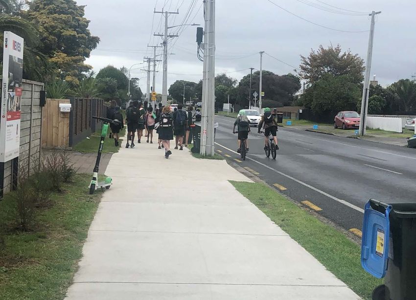
93.3. Pedestrians and cyclists
Pedestrians and cyclists along Links Avenue are dominated by school students and, importantly,
students from three schools. During our morning and afternoon site visits the SUP became
congested or blocked at times with large numbers of students walking, skateboarding,
scootering and cycling (Figures 8-10). At times cyclists appeared to be using the road as their
intended route, and at other times they would temporarily dart out into the road to avoid SUP
blockages.
Figure 8. Student cyclist approaching blocked footpath AM
Figure 9. Student cyclist approaching blocked footpath PM
MACKIE RESEARCH & COLIN BRODIE CONSULTING | LINKS AVENUE SCHOOL TRAVEL SAFETY
10Figure 10. Students cycling on road to avoid congested SUP.
Although Links Avenue is the location of primary interest, it is also worth noting some of the
pedestrian and cyclist behaviour at other nearby locations such as various crossing locations on
Golf Road, a particularly risky crossing at the intersection with Maunganui Road (Figure 11) and
the zebra crossing with an often over-flowing fenced refuge or informal crossing around it.
Figure 11. College students attempting to cross Golf Road.
MACKIE RESEARCH & COLIN BRODIE CONSULTING | LINKS AVENUE SCHOOL TRAVEL SAFETY
113.4. The overall nature, magnitude and likelihood of
risks to road users using the Links Avenue shared
use path
When the road, vehicle and user considerations are brought together, the risk of an injury
collision between a pedestrian/cyclist and a vehicle emerges from:
• little buffer space between the SUP and the adjacent traffic lane and inadequate SUP
width
• school students who travel in social groups with others negotiating them, and who
seem sometimes oblivious to nearby traffic and clustering around bus stops
• vehicles that often include buses. The risk of serious injury or death is greater for a bus,
truck or other heavy vehicle because of its frontal shape and mass, and potential to be
dragged underneath the wheels.
More broadly, the following table summarises our assessment of risks to road users including
school pedestrians and cyclists on the Links Avenue SUP. Following this is an explanation of the
ratings.
Road user Nature Likelihood Consequence
Stepping or spilling out onto Links
Pedestrians/scooters Avenue from SUP Medium Serious injury*
Crossing Links Avenue or Golf Road
Swerving out onto Links Avenue
from SUP
Cyclist Given insufficient space/cut off on Medium Serious injury*
Links Avenue
Crossing Golf Road
Sharing of traffic lane with larger
Motor scooters/bikes vehicles. Turning at driveways and Low-medium Serious injury
intersections
Turning into or out of properties on
Links Avenue
Motor vehicle occupant Medium-high Non/minor injury
Making U-turn on Links Avenue
Intersection with Golf Road
*The consequence could be a fatality if struck by a bus or truck.
Explanation for pedestrian assessment:
During our site visits we did not see any near misses on Links Avenue or Golf Road. However,
there is a large amount of mixing of pedestrians and busy traffic at risky locations. Furthermore,
there is evidence of periodic crashes involving pedestrians which often include school students.
Given the relatively low traffic speed and given the crash history, any pedestrian crash is likely
to result in minor to serious injury crash severity. However, if a pedestrian was struck or pulled
under a bus or truck then there is a chance of a fatality.
MACKIE RESEARCH & COLIN BRODIE CONSULTING | LINKS AVENUE SCHOOL TRAVEL SAFETY
12An interesting comparison exists with Manners Street in Wellington (Figure 12). Although this
has a much greater density of bus and pedestrian traffic throughout the day, a similar
pedestrian risk exists where pedestrians are operating on a footpath in very close proximity to
buses. Over the past ten years there have been 13 serious injury, 14 minor injury and two non-
injury pedestrian crashes on Manners Street, and sudden stepping out into the traffic into the
path of buses has been a common crash type.
This example shows that the close proximity of unpredictable vulnerable road users and buses is
likely to have safety implications, and the severity of any collision is likely to be severe given the
frontal shape and mass of buses.
Figure 12. Manners St, Wellington
Explanation for cyclist assessment:
During our site visits we witnessed cyclist movements that would pose considerable risk if a
passing car or bus happened to coincide with them darting out onto Links Avenue (probably to
avoid other students). Furthermore, there is insufficient cyclist space on the road on Links
Avenue which increases their proximity to motor vehicles, yet we noticed numerous school
children and commuters choosing to cycle on the road and in the bus lane. Along with the
recently reported cyclist incident and feedback from parents on the street, we witnessed
numerous occasions where cyclist movements could result in a near miss or crash and hence
our rating of crash likelihood is slightly higher at medium. Given the relatively low traffic speed,
any cyclist crash is likely to result in minor to serious injury crash severity. However, if a cyclist
was struck or pulled under a bus or truck then there is a chance of a fatality.
Explanation for motor-scooters/bikes risk
Motorcycles are a reasonably common form of transport for high school students, and we
noted a number of these. These are typically low powered and sometimes travel at lower
speeds than cars and buses. Along Links Avenue, these motorcyclists have no shoulder space to
utilise if necessary and are required to share the traffic lane or the bus lane in the morning
commute. Whilst the risks of crashes would be reasonably low, it can be an uncomfortable
experience with no space to pull over and let larger and faster vehicles pass.
MACKIE RESEARCH & COLIN BRODIE CONSULTING | LINKS AVENUE SCHOOL TRAVEL SAFETY
13Explanation for motor vehicle occupant assessment:
We witnessed numerous opportunities for motor vehicle to motor vehicle collisions as a result
of risky driving behaviour, and there are a greater number of motor vehicle crashes in the area
than pedestrian or cycle crashes, presumably due to their greater numbers over a 24-hour
period. However, given the relatively low traffic operating speeds in the area, notwithstanding
extreme driving behaviour such as excessive speed, then injury risk should be relatively low.
MACKIE RESEARCH & COLIN BRODIE CONSULTING | LINKS AVENUE SCHOOL TRAVEL SAFETY
144. Analysis and considerations for
future action
A range of recommendations have already been presented for addressing pedestrian and cyclist
safety concerns on Links Avenue related to the SUP (Links Avenue Options Investigations,
6 October 2020). Here we present our analysis of the situation and some considerations for
future action based on our observations and analysis.
4.1. Analysis
• The heart of the issue appears to be an inadequacy of the infrastructure to
accommodate and segregate all the transport demands, resulting in conflict between
major traffic network issues and the objectives for active and safe school travel. Traffic
has overflowed from Maunganui Road into Links Avenue and Golf Road, for those
travelling to the city in the AM peak. This has led to congestion on Links Avenue and the
need for bus lanes. It seems that priority needs to be given either to traffic congestion
or to the safety of active and bus school travel. This should be a strategy led decision,
and the strategy documents outlined earlier suggest that safe active school travel
should take priority on Links Avenue.
• It may be that this congestion is alleviated once the Baypark to Bayfair link is completed
and the bus lanes are not needed any longer. However, there is also a very real chance
that congestion does not improve as capacity limitations on Hewletts Road mean that
there will still be congestion on its approaches, and hence incentives for rat-running
traffic on Links Avenue. Furthermore, the improved road infrastructure is likely to
attract more traffic (induced demand 2) and maintain the levels of congestion in the
area, especially given the growth in development in the Eastern Bay area.
• The fundamental issue for Links Avenue appears to be the addition of the bus lane,
which has pushed the south eastern bound general traffic lane closer to the SUP which
has no berm or other separation. The SUP path width itself is inadequate to
accommodate the groups and contraflow of users in peak periods. Also, the north-
western bound bus lane is hard up against the kerb, resulting in cyclists having to share
this lane. Although the bus lane only legally operates between 7.15-10am, its use as a
general traffic lane, bus lane or parking is not clear, and we noted various uses.
• It is also interesting to note an earlier analysis of Mt Maunganui School travel 3 in 2009
when Links Avenue was operating more as a collector road, the concern was more
about traffic speed and personal safety related to certain households. These issues have
largely been addressed through gentrification and congestion, but concern about the
proximity of buses to cyclists (mentioned more for Valley Road and as an overall risk in
the 2009 report) is now focused on Links Avenue.
• The 2009 report mentioned above also shows that Mt Maunganui Intermediate has a
very strong culture of walking, cycling, and busing to school, and to some extent this is a
reflection of an effective and proactive school travel team at TCC over years, working
2
https://www.vtpi.org/gentraf.pdf
3
https://www.nzta.govt.nz/resources/research/reports/380/
MACKIE RESEARCH & COLIN BRODIE CONSULTING | LINKS AVENUE SCHOOL TRAVEL SAFETY
15closely with school communities. Our site visits confirmed this strong active travel
culture for the schools in the area and the predominance of teenage girls cycling to
school is a very healthy sign as in many other cities this group is often non-existent. As
national leaders in school active travel, this should be supported and made as safe as
possible.
• When looking across the system for intervention solutions, when it comes to road user
behaviour the characteristics and typical behaviour of school students needs to be
taken into consideration. School aged pedestrians and cyclists may not act as
consistently as we might wish and part of this is a result of their developing brains. This
is supported by the following quote:
“You have to take the human and our behaviour into account when you design the
road transport system” - Claes Tingvall - Originator Vision Zero Sweden
Hence, a simple mistake by school students should not cost them serious injury or
death because the margins for error in the path/road design are minimal.
4.2. Considerations for future action
It is our view that the current road design on Links Avenue is associated with an unacceptable
margin for error for pedestrians and cyclists, and a moderate and tangible risk to vulnerable
road users, cyclists in particular.
Barrier between shared use path and vehicles?
A seemingly obvious solution is to erect pedestrian fencing along the extent of the SUP from
Golf Road to the Mt Maunganui school gate, as this would separate pedestrians and cyclists
from traffic. However, a number of disadvantages need to be considered:
• In the UK, although in a different context, pedestrian fencing removal has been
associated with a reduction in crashes 4
• Potentially, pedestrian fencing provides a false sense of safety from a drivers’
perspective, and hence and their speed and awareness do not reflect the potential risk
of a pedestrian or cyclist suddenly emerging from an opening in the fencing (such as a
driveway)
• Cyclists, as shown earlier in the report, may be more sudden in their darting out at
driveways, especially if they are stuck behind groups of walking students for some time
• Cyclists using the road may become trapped between a vehicle and the fencing,
particularly if there is insufficient cyclist space
• The fencing may partially obscure pedestrians and cyclists who may suddenly appear on
the road way
• Already the SUP is narrower than the 3m which it should ideally be, and the fencing will
remove further space from the path
• Potentially greater difficulty in residents entering and exiting driveways.
4
https://content.tfl.gov.uk/pedestrian-railings-removal-report.pdf
MACKIE RESEARCH & COLIN BRODIE CONSULTING | LINKS AVENUE SCHOOL TRAVEL SAFETY
16Reverting to two-lane traffic
We feel that safety risk would be addressed if the road reverted to two-lane traffic, allowing a
greater shoulder and buffer between SUP users and traffic. This would better reflect the design
and function of Links Avenue, given that it is such an important active travel corridor for three
schools. This would disadvantage either general traffic or bus traffic however, but as mentioned
earlier, on a strategic basis safe active school travel should be prioritised.
Restrict Access to general traffic during the AM peak
We’ve also learned that bus travel is very important for school students in the area and so
retaining amenity for bus travel is preferred. In an earlier TCC report - Links Avenue Options
Investigations, a cul-de-sac option for Links Avenue was explored, and accompanying traffic
modelling has been provided. We believe a temporary trial of bus only access for north-western
bound traffic on Links Avenue during the AM peak, as part of reverting Links Avenue to two
lanes, has merit. This may shift some congestion to Maunganui Road, Ocean Beach Road, and
Golf Road as suggested by traffic modelling but, as mentioned, earlier decisions should be
strategically based as well as tested to see what happens.
A ‘tactical’ approach could be used to do this relatively cheaply to test the arrangement and so
the cost should not be high. The existing Waka Kotahi led Innovating Streets programme
provides considerable guidance for how this kind of approach might be used.
Variable speed limit
An interim measure, if the above more robust solution proved too difficult to implement, could
be the introduction of a variable speed limit of 20 or 30 km/h during AM and PM school times. A
Safe System speed involving vulnerable road users is generally accepted as 30 km/h. However,
this targets elimination of most deaths but not serious injuries and this does not reflect the
added severity associated with pedestrian/bus collisions. Speeds were already down to around
30 km/h in the AM peak near the raised zebra crossing and at other locations on Links Avenue.
However, for southeast bound traffic generally, and for the PM school time, a 20 or 30 km/h
speed limit may help with safety.
We also know from other variable speed limit applications that the signs play an important role
in increasing driver alertness, which may be useful within the context of unpredictable
pedestrians and cyclists.
MACKIE RESEARCH & COLIN BRODIE CONSULTING | LINKS AVENUE SCHOOL TRAVEL SAFETY
17You can also read