Long Term Plan 2012-2022 - Tasman District Council 17 Settlements Water will be a key element to the future prosperity of the Tasman District
←
→
Page content transcription
If your browser does not render page correctly, please read the page content below
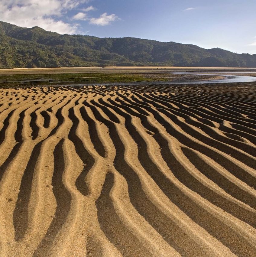
Tasman District Council
17 Settlements

Long Term Plan 2012–2022
including the Annual Plan 2012/2013

Water will be a key element to the future prosperity of the Tasman District
Tasman District Settlement Areas
PURPOSE OF THE 17 SETTLEMENTS DOCUMENT
The Council has decided to prepare this 17 settlements document as supplementary information to
the Long Term Plan 2012-2022, to make it easier for people to find out what is happening in their
local area. The 17 settlements, by ward, are:

Golden Bay Ward:                                     Motueka Ward:
   • Takaka                                            • Motueka
   • Pohara/Ligar Bay/Tata Beach/Tarakohe              • Kaiteriteri
   • Collingwood                                       • Marahau
                                                       • Riwaka
Richmond Ward:
   • Richmond                                        Lakes-Murchison Ward:
                                                        • Murchison
Moutere-Waimea Ward:                                    • St Arnaud
  • Brightwater                                         • Tapawera
  • Coastal Tasman
  • Wakefield
  • Mapua/Ruby Bay
  • Tasman
  • Upper Moutere

This 17 Settlements document begins with an overview of the District-wide financial and rating
information. It then briefly summarises the growth projection work undertaken by the Council. The
document also outlines the projects and services planned District-wide, by ward and by settlement
over the 10 years 2012-2022.

LONG TERM PLAN 2012-2022
The Long Term Plan comprises:
   • Volume 1, which outlines the vision for the District, the outcomes sought by the community,
      the services and activities Council is planning to undertake, and the likely costs of providing
      those services and activities over the next 10 years.
   • Volume 2, which contains the various policies Council is required to include in its Long Term
      Plan (Funding Impact Statement (which outlines the targeted rates in detail), Schedule of
      Charges, Investment Policy, Liability Management Policy, Revenue and Finance Policy, Rates
      Remission Policies, Significance Policy, Statement on Fostering Maori Participation in Council
      Decision-Making, Development Contributions Policy, and a summary of any differences
      between the Long Term Plan and Council’s Water and Sanitary Services Assessment and
      Waste Management and Minimisation Plan, and the Rating Maps).

The Long Term Plan documents are available from Council’s website (www.tasman.govt.nz) or from
Council offices or libraries on CD or hard copy. We encourage people to use the CD or website
versions of the document to reduce printing costs and because it is better for the environment. In
addition, we also have activity management plans for most Council activities. Copies of these are
available on CD or on the website.

AUDIT OPINION
The Council has received a clear audit opinion on its Long Term Plan. The audit opinion is contained
in Volume 1. The audit opinion does not cover the 17 settlements document or the Council’s activity
management plans, as these documents are supplementary information to the Long Term Plan.
                                                                                                   1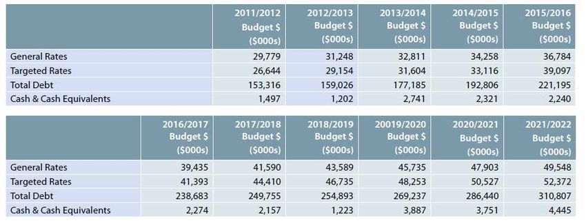
DISTRICT-WIDE FINANCIAL AND RATING INFORMATION

Council’s 10 year financial performance summary

We have considered the various issues facing the District over the coming 10 years and what Council
could do about them. Our priorities when preparing the Long Term Plan have focused on making
sure we can, at an affordable cost to ratepayers:
    • Maintain the existing core infrastructure in our communities.
    • Provide and maintain the infrastructure necessary for our growing communities, businesses
       and industries.
    • Meet our legislative requirements to deliver services.

We have prioritised the activities and projects. Not all the large number of the projects and activities
asked for in our consultation with the community during the preparation of the Long Term Plan could
be included in the budgets, due to concerns about affordability (refer to Appendices 4 and 5 of
Volume 1 of the Long Term Plan for details of the key projects and services asked for that are not
included in the Plan). Submissions on the Draft Long Term Plan requested that Council add in an
additional approximately $30 million of projects and services into the budgets over the 10 years of
the Plan.

The financial information in this Plan reflects the activities and projects the Council has identified as
priorities, and plans to deliver over the coming 10 years.

Consultation on Draft Long Term Plan

The Draft Long Term Plan was publicly notified calling for submissions on 29 February 2012, with
submissions closing on 3 April 2012. The final Long Term Plan was adopted by Council on 27 June
2012.

We produced a Summary of the Draft Long Term Plan, as a special edition of Council’s Newsline.
The Summary was sent to every household and ratepayer in the District.

We ran a series of consultation discussion sessions around the District on the Draft Long Term Plan
during March. The public consultation included informal discussion sessions during the daytime with
Councillors and staff available to answer questions, usually followed by a more formal presentation
and question sessions in the evenings.

A total of 901 submissions were received on the Draft Long Term Plan with 180 submitters wishing to
be heard. Council wishes to thank everyone who submitted on the Draft Plan.

    Key topics raised in submissions                      Approx. number of submissions received
    Lee Valley Dam                                        128
    Saxton Field facilities including the cycling track   123
    Kaiteriteri Road                                      99
    Tasman’s Great Taste Trail cycleway                   96
    Motorsport facility                                   63
    Aerodromes                                            58
    Water Supply                                          42
    Tourism Rate                                          37
    Refuse / Recycling /Solid waste                       36
    Road cycleways                                        25
    Rates Affordability / Targeted Rates                  24

In addition to the specific matters raised above there were approximately 80 submissions that
covered several of the matters listed above, along with other subjects.
                                                                                                       2
Key Changes

Some of the key changes made between the Draft Plan and this final Plan as a result of submissions
include:
   •   Agreeing to retain the Lee Valley Dam project in the Long Term Plan, but noting that Council
       will work with the Waimea Water Augmentation Committee, and consult with other interested
       parties, to refine the funding model and costs of the project.
   •   Providing a further $4.55 million funding towards the completion of Tasman’s Great Taste Trail
       loop over the years from 2012 – 2019. To offset this project Council has deleted a number of
       projects previously planned for Saxton Field. Council has also signalled that the stages of the
       project are dependent on contributions from the Government and the community.
   •   Putting $3 million of the special dividend from Port Nelson into Council’s disaster fund and
       using the remaining $1 million to reduce general rate funded debt.
   •   Introducing a new Tourism Activity Targeted Rate as proposed in the Draft Plan, which is to be
       charged as a flat rate across all the District’s rateable properties. Council has also agreed to
       undertake a review of its ongoing involvement in and funding of tourism activities by 30/06/13.
   •   Including $60,000 funding for a joint study in 2013/2014 of the three roundabouts near
       Champion Road with the New Zealand Transport Agency and Nelson City Council.
   •   The $1.7 million upgrade of the Graham Valley Road has been deleted from years 2019-2021
       of the final Long Term Plan to help reduce overall levels of debt.
   •   Council’s share of funding for roading and other transportation projects has been retained at
       much the same levels as provided for in the Draft Plan, even though the New Zealand
       Transport Agency has reduced the Government funding for local roads in Tasman District and
       not provided an inflation adjustment for roading work for the first three years of the Plan.
   •   Some further funding has been provided in the Long Term Plan for erosion control work at
       Jackett Island. $671,450 has now been included in 2012/2013 to develop a preferred option
       and obtain a resource consent. $2.8 million has been provided in 2013-2015 to implement the
       preferred solution.
   •   Changing the solid waste budget to amend the costs of the Emissions Trading Scheme from
       $20 per NZU to $15 per NZU and to delay some of the capital works projects planned at the
       resource recovery centres and landfill.
   •   Amending the areas and properties where the refuse and recycling rate is payable.
   •   Delaying and deleting some of the projects proposed in years 2012-2018 of the Draft Long
       Term Plan at Saxton Field to align Council’s work programme with the changes proposed by
       Nelson City Council but at the same time still providing for major new developments to meet
       community needs. Projects removed were funding for the shifting of the radio mast, purchase
       of additional land; and projects reduced included the planned expenditure on two ponds.
   •   Increasing the water rate in 2012/2013 due to the dispute with the Industrial Water Users not
       being resolved at this stage.
   •   Amending some fees and charges.
   •   Deleting the proposed new wharf costing $1.3 million in 2013/2014 and marina costing $1.04
       million in 2012/2013 at Port Tarakohe and replacing them with a new weigh bridge and wharf
       crane costing a total of $290,640 in 2012/2013.
   •   Reducing the funding for the Lower Motueka Flood Control project to $5 million within the 10
       years with the intention of reviewing the scope and timing of the project.

                                                                                                       3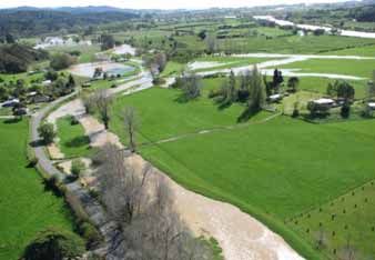
•    Increasing the low flow restricted water supply rate discount from 10 to 20 percent, so that
         customers on these water supplies will pay 80 percent of the cost of water per unit charged to
         urban supply customers. They do not pay the daily charge paid by urban supply customers.

Council’s overall financial summary

Please refer to the full Long Term Plan for Council’s prospective income statement, prospective balance sheet, prospective cash flow statement,
prospective statement changes in equity, prospective cash flow reconciliation, projected revenue by activity and summary funding impact statement.

Rating information:

Council has worked hard to prioritise the services and projects for the District’s future, to provide
them when they will be needed, and at an affordable cost. The annual general rates increases
averaging 3.93 percent over the 10 years covered by the Plan, including an allowance for inflation,
which is running at around 3.8 percent and also allowing for 1.3 percent population growth. The
proposed general rates increase for 2012/2013 is 3.63 percent (including inflation).

                                                                                                                                                4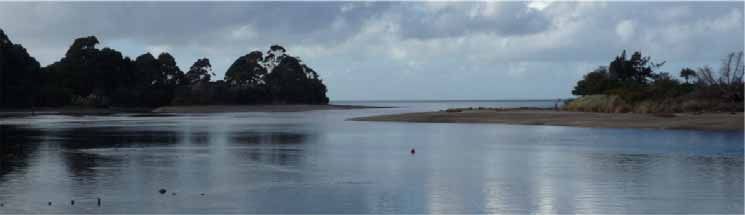
We have not increased the uniform annual general charge, which remains at $288.78 (including
GST) per rating unit.
Targeted rates are scheduled to increase considerably over the 10 years of this Plan. Council
considers that where direct beneficiaries of Council services are identified, a targeted rate provides
more transparency and reduces cross subsidisation of those not directly benefiting from the service.
Targeted rates as a percentage of total rates are expected to rise from 48.3 percent in 2012/2013 to
51.4 percent by 2021/2022. For a more detailed analysis of how targeted rates will affect you for the
2012/2013 year please refer to the Financial Strategy contained in Volume 1 and to Council’s
Funding Impact Statement in Volume 2 of the full Long Term Plan.
New targeted rates proposed over the 10 years are:
Targeted rates discontinued over the 10 years are:
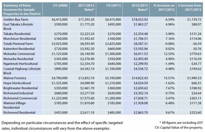
Examples of Total Rate Changes for Properties
To further clarify the rates rises between the 2011/2012 year and those for the 2012/2013 year, a
selection of properties from throughout the District have been summarised to provide a guide. It is
important to note that these properties are a sample of the total properties and do not cover all
situations for the 21,577 rateable properties in the District.
The following table is GST inclusive. It covers the total rates increases, incorporating the increases
in the General Rate of 3.63 percent and Targeted Rates, and the effects of the 2011 triennial
valuation changes.
The triennial revaluations mean that if a property’s valuation has increased more than the average
property valuation change in the District (e.g. the Richmond property in the sample properties in the
table on the next page) then the rates increase for that property will be higher than the average
increase across the District. However, if a property valuation change is less than the average (e.g.
the Hope Horticulture property in the table on the next page) then the rates increase will be less than
the average increase. Refer to pages 22-23 of the Draft Long Term Plan for tables showing the rates
increases proposed in the Draft Plan comparing the proposed rates figures before and after valuation
changes.
The 2012/2013 rates in the table on the next page are based on the 2011 property valuations.
5
If you want to know what will be happening to your rates, please give us a call or go to our website
(www.tasman.govt.nz) to find out.

Our debt profile over the 10 years

Council is planning to spend $404.8 million (including inflation) on capital projects over the next 10
years. These projects will provide infrastructure that will last for many years. We plan to loan fund
much of the expenditure over a 20 year repayment term, with the exception of community facilities
and Motueka Flood Control loans which are repaid over 40 years, and also where it is assessed the
asset life is shorter than 20 years the loan is shortened to match this. Using loans means that people
who get the benefit of using the service or facility over its lifetime, pay for it, rather than all the cost
falling on current ratepayers. Council incurring debt is very similar to raising a loan to purchase a
house.

Council is expecting that interest rates are likely to increase over the next 10 years and an allowance
has been made for this in the budgets contained in this Plan. Council is very mindful of the effects of
interest rates on its debt and through our Liability Management Policy uses interest rate hedging
instruments to smooth out the highs and lows of interest rate movements. In preparing this Plan we
obtained independent advice on treasury matters to strengthen our financial management and
reporting. Our loans were about $139 million as at June 2011 and are expected to rise to about
$310.8 million by 2021/2022. While our loans are increasing, they remain within our Liability
Management Policy and debt limits.

We consider it is prudent to debt fund major infrastructure projects as this approach enables future
users of the infrastructure to contribute to its cost.

                                                                                                          6
The projected increase is required to upgrade existing assets to meet new regulatory requirements,
for example upgrading all the water supplies in urban areas and upgrading the Motueka and Takaka
Wastewater Treatment plants, and make improvement to some existing assets.
The following graph shows the net increase in debt by main activity, that is, new loans raised minus
debt repayments for new and existing loans. The graph shows that nearly all the projected increase
over the next 10 years is for engineering assets.
7KEY ISSUES
The priorities Council has identified tie into the key issues in the Long Term Plan and the projects we
will undertake. The Key Issues section is one of the most important in the document. The key issues
we’ve identified are listed below, however, we encourage you to read the information on them in
pages 32-53 of Volume 1 of the Long Term Plan, which states what the issues are and what the
Council is planning to do about them. These pages also contain any major changes to the services
that Council currently delivers.
The key issues are:
1. Rainfall event December 2011.
2. Financial Strategy.
• Debt.
• Rates and inflation.
3. Transportation, Roading and Footpaths issues.
• Reducing levels of Government funding.
• Kaiteriteri Road.
• Tasman’s Great Taste Trail.
4. Water supply.
• Motueka water supply.
• Coastal Tasman pipeline.
• New Richmond water treatment plant.
• New drinking water standards.
• Low flow restricted water supply rates.
• Pohara water supply proposed to join Urban Water Club.
• Water supply agreements with Nelson City Council and Industrial Water Users.
5. Wastewater.
• Infrastructure upgrades causing pan charges to increase.
• Infrastructure not included in the 10 years.
• Nelson Regional Sewerage Business Unit budgets.
6. Stormwater.
• Catchment management planning and hydraulic modelling requirements.
• Infrastructure upgrades leading to rates increases.
7. Emissions Trading Scheme
8. Flood Protection.
• Lower Motueka Valley Flood Control Project
9. Community Services.
• Shared facilities.
• District facilities.
10. Aerodromes.
11. Port Tarakohe.
812. Sustainable development.
• Managing our land and land use.
• Projected growth and demand for land and services.
• Economic growth.
• Climate change.
13. Iwi and Māori matters.
14. Amalgamation Proposal.
15. Tourism funding and targeted rate.
16. Community Board targeted rate.
17. Lee Valley Dam.
9PROJECTED GROWTH OF SETTLEMENT AREAS
Tasman District has been facing moderate levels of population growth over recent years. This
population growth, along with other factors, has stimulated economic growth in the District. Council is
of the view that population growth will continue to occur in most parts of the District. Council
considers that population growth and sustainable economic growth are desirable, and we are
planning infrastructure and community facilities to meet the expected demand for growth.
The number of people in the District and where they choose to live, and the growth in the economic
activity, directly affect the demand for land available for development, infrastructure and the other
services Council provides. Population and employment growth figures are, therefore, critical
indicators of demand. They underpin our land use planning, infrastructure developments, where and
when new services or facilities are required, and how much things will cost.
Council considers that the growth modelling work it undertook during the preparation of the Long
Term Plan has been very robust. It was important to determine how many people we are likely to get
in the District over the next 20 plus years and where they are likely to want to live. The growth
modelling exercise estimated the demand for land and services created from the projected increase
in population and in demand for holiday homes, business and industrial uses. We then looked at how
to supply that demand over at least the next 20 years.
The growth modelling work identified what the likely demand for property would be in each of the 17
principal settlements within the District. The next step was to look at where the additional people and
business activities could be accommodated on land suitable for the required development. This work
took into account a range of factors including:
• The productive value of land.
• Potential hazards (like flooding and inundation from the sea due to climate change and other
factors).
• Potential impacts on amenity, water margins, and natural and historic resources.
• The ability to provide infrastructure services (like stormwater, water, wastewater and roads).
• The need for community facilities (like reserves and community halls).
• Accessibility to town centres and employment opportunities.
Council looked at what infrastructure (water supply, stormwater, wastewater, roading, community
facilities, reserves, etc.) would be required to meet the needs of the current and future population,
and for business, in the District’s settlements. This work fed into the Activity Management Plans that
the Council has prepared for its key activities and services (copies of the Activity Management Plans
are available on the Council’s website www.tasman.govt.nz or from the Council on a CD).
The cost of providing the infrastructure, community facilities and services has then fed directly into
the budget forecasts contained in the Long Term Plan.
Council acknowledges that growth projections are sensitive to a number of factors, many of which are
outside our control. In preparing the Long Term Plan and the accompanying Activity Management
Plans, Council was mindful of the potential impact of higher or lower rates of growth. The current
economic climate leads to increased uncertainty around the levels of growth we could expect.
Should the population not reach the anticipated levels, proposed projects, activities and levels of
service will be reviewed during the preparation of Annual Plans over the next two years and again
when the Long Term Plan is reviewed in 2015.
As a consequence of lower than anticipated growth, some projects may be delayed or debt-funded at
higher levels until the population growth is achieved. On the other hand, should population
projections be exceeded, the Council may need to bring forward some projects.
10PROPOSED NEW ACTIVITIES AND SERVICES BY DISTRICT, WARD AND SETTLEMENT
During the preparation of the Long Term Plan, Council has been through a tough decision making
process on what services and projects it should be providing over the coming 10 years. We have
avoided spending on things that will not benefit the long term future of our District. We have focused
on maintaining and providing the infrastructure necessary for our growing communities.
Unfortunately we cannot do everything. In the following pages we outline, by District and settlement,
the main new projects and services Council will undertake during the coming 10 years and an
indicative list of major projects for the following 10 years (2022/2023 – 2031/2032).
In addition to the new projects and services, Council has budgeted funding to continue delivering
most of the existing activities and services it provides, and for ongoing maintenance and renewal of
existing assets. This includes Council’s policy and regulatory functions which do not involve large
capital projects.
District-Wide Activities and Services
We plan to provide the following new facilities and services on a District-wide basis during the first 10
years:
Environmental Management
Reviews and changes to the Tasman Resource Management Plan including:
• Reviewing and combining the Tasman Regional Policy Statement with the Tasman Resource
Management Plan.
• Completion of Richmond urban development changes.
• Mapua-Ruby Bay change.
• Motueka West and Central change.
• Takaka urban review.
• Brightwater & Wakefield reviews.
• Small settlement reviews in Golden Bay and Tasman Bay.
• Rural policy reviews, including subdivision and rural land-use, and landscape protection.
• Land disturbance review.
• Water allocation reviews.
• Preparation of a riparian land management strategy.
• Natural hazards strategic policy review.
Transportation, Roads and Footpaths
• Tasman’s Great Taste Trail – completion of trail loop by 2018/2019.
• Minor safety improvements to roads throughout the 10 years.
• Emergency reinstatement of roads throughout the 10 years.
• Bridge renewals – locations to be determined using prioritisation process and NZ Transport
Agency funding criteria.
• New footpaths in the District, but no new footpaths are planned in the first three years.
• Renewal of road signs, street lighting and marker posts District-wide throughout the 10 years.
• District-wide kerb and channel, and pram crossings throughout the 10 years.
Some of the projects noted above will occur subject to a receipt of a satisfactory New Zealand
Transport Agency subsidy.
11Water Supply
• Lee Valley Dam – investigation and Council’s contribution to the construction costs relating to
ensuring an adequate water supply for Richmond, Wakefield and Brightwater, and maintaining
environmental flows in the river (2015/2016) – subject to a review of the proposed funding
model.
• Ongoing upgrades and renewals to pumps, pipelines, values, telemetry, water meters and
restrictors throughout the District throughout the 10 years.
Wastewater and Sewage Disposal
• Pump station upgrades and renewals throughout the District throughout the 10 years.
Solid Waste
• Resource recovery centre upgrades throughout 10 years.
• Eves Valley Landfill improvements throughout the 10 years, including gas capture equipment
to reduce liabilities for producing greenhouse gas emissions under the Emissions Trading
Scheme. (subject to the outcome of discussions with Nelson City Council on waste
management across Nelson and Tasman).
• Maintaining closed landfills, throughout the 10 years.
Community Facilities and Parks
• To complete a Community Halls Strategy.
• To implement the Building Maintenance Plan.
• Provide new or improved toilets on recreation reserves (2013/2014, 2014/2015, 2015/2016,
2016/2017, 2018/2019, 2019/2020, 2020/2021).
• Continue to work with the community on revegetation projects throughout the 10 years.
• Contribution to Saxton Field developments including land purchases, walkways and roads,
cycle track, cycle/soccer pavilion and hockey turf, throughout the 10 years.
• Contribution to the Brook Sanctuary fence (2013-2015).
• Radio Frequency Identification Technology at libraries (2014/2015).
• Library book renewals and additional borrowing items throughout the 10 years.
• Provision of new parks and reserves walkways throughout the District over the 10 years.
12Golden Bay Ward
This Ward includes the following settlements:
• Takaka.
• Pohara / Ligar Bay / Tata Beach / Tarakohe.
• Collingwood.
Major projects at the Ward level include:
• To complete the investigation and construction of a community facility (location still to be
determined within Golden Bay) (2013-2015).
• New or improved toilets in Golden Bay (locations still to be determined) (2015/2016,
2018/2019, 2020/2021).
• Funding for new playgrounds (locations still to be determined) (2012/2013, 2016/2017,
2019/2020).
• Contribution to upgrading a Golden Bay School pool (2018/2019).
• Security cameras (2014/2015, 2017/2018, 2020/2021).
• Artworks in Golden Bay (locations still to be determined) (2013/2014, 2017/2018).
Takaka Settlement Area (refer to the attached Takaka Growth Model and Infrastructure maps)
Population Projection
Population
adjusted
Settlement Series
Population. to SNZ 2011 2016 2021 2026 2031
Area Applied
2006
Estimate
Takaka 1133 1163 Medium 1173 1173 1153 1113 1062
The projected decrease in population of 111 people represents a decrease of 9.5 percent between
2011-2031 for Takaka. However, including people not living in a main settlement in Golden Bay, the
population in Golden Bay is expected to increase.
Takaka is the largest urban settlement in Golden Bay. Over the years it has attracted both local and
overseas holiday makers as well as permanent residents seeking an alternative lifestyle. Today, the
area plays a major role in the District's dairying industry.
The opportunity to expand the existing urban area is limited as it is low lying and subject to the risk of
flooding from the Takaka River.
Growth Planning
The Council has developed a framework for settlement planning in the Takaka - Eastern Golden Bay
area since 2005, in consultation with the community. This has resulted in Change 8 to the Tasman
Resource Management Plan (TRMP). The planning policies identify preferred locations for future
residential development and seek to avoid further residential development on productive or flood
prone land and to discourage dispersed and ribbon development along roads and the coastline.
These policies apply to Takaka and seek to prevent further residential expansion of the existing town.
The TRMP identifies the following alternative residential development areas: (i) intensification of the
existing residential area in Rangihaeata; (ii) the development of a new residential area at south
Takaka centred on Park Avenue; (iii) possible low density residential development on the eastern
13flank of the Rototai Hill – Hambrook Road landform; and (iv) possible low impact, low density
development at Motupipi Hill. Refer to the attached Takaka Growth Model map.
In 2010/2011 Council initiated a Takaka River Flood Hazard modelling project which aimed to provide
further information and understanding on the nature of the flood hazard posed by the lower Takaka
River. This project has progressed to initial public discussion of the model outputs and potential
responses to the risk identified in early 2012. Just prior to adoption of the LTP the Council decided to
not progress further work on regulatory planning responses to Takaka’s flood risk. This includes
work on opening a new development area at Park Avenue. Through the Landscape Project in Golden
Bay there may also be implications for future development in other locations listed in the paragraph
above.
Future business demand is expected to be satisfied from land already zoned for business purposes
in Takaka, within the constraints identified by the flood modelling work.
Major Projects Planned for Takaka between 2012/2013 to 2021/2022
Engineering (refer to the attached Takaka infrastructure map):
• Takaka wastewater treatment plant upgrade (2012-2015).
• Takaka wastewater pipeline renewals (2016/2017 and 2021/2022).
• Stormwater:
o Waitapu Road new stormwater pipes (2017/2018).
o Meihana Street stormwater pipe upgrade (2019-2021).
o Commercial Street stormwater pipe upgrade (2012-2016).
• Improvements to Takaka solid waste resource recovery centre (2013-2022).
• Takaka Flood Control project investigation/consultation (2019-2022) – with construction (if
applicable) towards the end of the 10 years and into the subsequent 10 years.
Community services:
• Takaka Memorial Reserve landscaping throughout the 10 years.
• Takaka Aerodrome runway resurfacing and remarking (2020/2021).
• Golden Bay multi-use facility (2012-2015).
• Golden Bay Recreation Reserve upgrade (2013 -2017, 2018/2019).
• Golden Bay Tennis Courts upgrade (2013/2014).
Indicative Major Projects for Takaka between 2022/2023 to 2031/2032
Engineering:
• Development of a new cycle facility along Abel Tasman Drive from Takaka to Pohara..
• Park Avenue and Sunbelt Crescent wastewater pump station renewals.
• Takaka wastewater pipeline renewals.
• Further improvements to Takaka solid waste resource recovery centre.
• Takaka River Flood Hazard project (construction – if applicable).
Community Services:
• Business as usual. There are no major changes proposed in years 11-20 at this stage.
• Funding for parks and reserves walkways continuing through the next 10 years.
• Ongoing management, maintenance, planting and development of existing reserves and
facilities.
• Purchase and development of new reserves and facilities to meet the needs of the District’s
growing population.
14Pohara / Ligar Bay / Tata Beach / Tarakohe Settlement Area (refer to the attached Pohara/Ligar
Bay/Tata Beach Growth Model and Pohara Infrastructure maps)
Population Projection
Population
adjusted
Settlement Series
Population. to SNZ 2011 2016 2021 2026 2031
Area Applied
2006
Estimate
Pohara/Tata/
Ligar/Tarakohe 738 758 Medium 785 807 823 835 841
The projected increase in population of 56 people represents an annual average growth rate of
7.13% between 2011-2031 for Pohara / Ligar Bay / Tata Beach / Tarakohe.
Growth Planning
This settlement area has developed substantially over the past 20 years as a holiday and retirement
area. There is one small reticulated water supply in Pohara Valley. Through Change 8, the TRMP
identifies at Pohara, the intended development of a new residential area south or inland of Abel
Tasman Drive on land currently zoned Rural 2. A 2011 review of potential growth identified that the
expected residential demand to 2031, could be largely satisfied from land already zoned for
residential or rural residential purposes in parts of Pohara, Ligar Bay and Tata Beach. However, a
recent extreme rainfall event (December 2011) which caused significant damage, particularly in
Pohara Valley and Ligar Bay has sparked concern over the suitability of some areas for development.
This aspect is under investigation and consideration and will inform structure planning work
programmed within the ten years. Refer to the attached Pohara/Tarakohe/Tata/Ligar Bay Growth
Model map.
Future business demand is expected to be satisfied from the Port Tarakohe industrial area.
Major Projects Planned for the Pohara / Ligar Bay / Tata Beach / Tarakohe area between
2012/2013 to 2021/2022
Engineering (refer to the attached Pohara infrastructure map):
• Port Tarakohe developments including new weigh bridge and wharf crane (2012-2014)
• Upgrade of Pohara water treatment plant to meet the Government’s new drinking water
standards (2012-2015).
• Upgrade of Pohara Valley wastewater reticulation (2016-2018) and Pohara/Tata
Beach/Tarakohe/Four Winds pump stations and rising mains (2012-2014 and 2016-2018).
• Ligar Bay – Abel Tasman Drive stormwater culvert (2013-2017).
Community Services:
• Funding for parks and reserves walkways continuing through the 10 years.
• Continue to support coastcare projects running at Tata Beach, Ligar Bay and Pohara.
Indicative Major Projects for Pohara / Ligar Bay / Tata Beach / Tarakohe area between
2022/2023 to 2031/2032
Engineering:
• Development of a new cycle facility along Abel Tasman Drive from Takaka to Pohara.
• Development of a new cycle facility from Ligar Bay to Tata Beach.
• Ligar Bay/Tata Beach wastewater pump station and rising main upgrades.
15• Upgrade stormwater culverts and upsize channels in Pohara.
Community Services:
• Ongoing management, maintenance, planting and development of existing reserves and
facilities.
• Ongoing coastcare work, including planting and dune restoration.
• Funding for parks and reserves walkways continuing through the next 10 years.
Collingwood Settlement Area (refer to the attached Collingwood Growth Model and
Infrastructure maps)
Population Projection
Population
adjusted
Settlement Series
Population. to SNZ 2011 2016 2021 2026 2031
Area Applied
2006
Estimate
Collingwood 229 235 Medium 244 251 256 260 262
The projected increase in population of 18 people represents a growth rate of 7.4% between 2011-
2031 for Collingwood.
Collingwood is located adjacent to the Ruataniwha Inlet where the Aorere River flows into the sea.
The coastal scarps which separate the upper and lower parts of Collingwood are unstable and have
not been zoned urban. They also add to the character of the town in their natural state. The end of
the Collingwood sandspit is a mobile feature that is unsuitable for permanent structures.
Protection of Collingwood's heritage values and the enhanced urban design of Tasman Street are
encouraged. Recreational fishing facilities in and adjoining the Aorere Estuary are encouraged to
integrate with appropriate onshore facilities and the natural character of the inlet.
Growth Planning
Future residential and rural residential development is encouraged to locate to the south of the
existing residential area to avoid spread along the coastline or into areas that are highly visible or
have high natural values. Refer to the attached Collingwood Growth Model map.
Future business demand is expected to be satisfied from land already zoned for business purposes.
Major Projects Planned for Collingwood between 2012/2013 to 2021/2022
Engineering (refer to the attached Collingwood infrastructure map):
• Seal extension Freeman Access to Paddle Crab Café (2018/2019).
• Collingwood water treatment plant upgrade to meet new Government drinking water standards
(2015-2017).
• Collingwood wastewater treatment plant renewal of flow meter, pumps, etc (2015/2016),
improvement of wetlands (2014-2016) and Motels pump station renewal of pumps
(2015/2016).
• Improvements at Collingwood solid waste resource recovery centre (2012/2013-2014/2015,
2015/2016-2021/2022).
16Community Services:
• Continue to support the Coastcare projects running at Collingwood and Pakawau during the
10 year period.
Indicative Major Projects for Collingwood between 2022/2023 to 2031/2032
Engineering:
• Collingwood streetscaping.
• Gibbs Road stormwater diversion.
Community Services:
• Funding for parks and reserves walkways continuing through the next 10 years.
• Ongoing management, maintenance, planting and development of existing reserves and
facilities.
• Ongoing coastcare work, including planting and dune restoration.
17Richmond Ward
The Richmond Ward includes the Richmond settlement area (refer to the attached Richmond Growth
Model and Infrastructure maps).
Richmond Settlement Area
Population Projection
Population
adjusted
Settlement Series
Population. to SNZ 2011 2016 2021 2026 2031
Area Applied
2006
Estimate
Richmond 12953 13297 Medium 14036 14714 15322 15930 16458
The projected increase in population of 2,422 people represents a growth rate of 17.25% between
2011-2031 for Richmond. Richmond is the largest urban settlement in Tasman District. Over the last
15 years it has experienced moderate growth with people attracted by the surrounding natural
beauty, climate and proximity to the neighbouring city of Nelson.
Growth Planning
Council has been undertaking urban Growth Planning for Richmond over the past ten years,
commencing with Richmond CBD studies (2002) and the Richmond Development Study (RDS),
circulated for community feedback in 2003. An extension to the RDS was the Hill Street East Study.
The RDS recognised that providing for growth would influence the urban form of Richmond (i.e.
would it grow up, grow out or stay put). Planning principles were formulated and consultation with the
community was sought on these and different urban and growth options, namely: Central area
intensification; South Richmond; Richmond East / South Nelson; and Lower Queen Street (Richmond
West). This consultation feedback was acknowledged and is reflected in the RDS planning approach
and the Council decisions for the urban development of Richmond. As a result of the RDS, the
strategic approach to Richmond’s future development, Council is planning to provide for:
• Defined southwards expansion of Richmond, between State Highway 6 north of Hope and Hill
Street to create a high amenity residential environment, (Richmond South Development Area).
• Residential and business intensification of central Richmond.
• Defined residential intensification in suitable locations in Richmond East, including land south
of Champion Road and east of Hill Street, and support for defined northward residential
expansion towards Stoke in Nelson City, north of Champion Road (Richmond East / Nelson
South Development Area).
• Defined westward expansion of Richmond to create a high amenity urban environment for
business and residential development (Richmond West Development Area).
As development proceeds, a network of public greenways will be developed that accommodate the
natural stormwater system and walking and cycling routes. The greenways connect the various parts
of Richmond and link Richmond with the hills and the sea. Also, the natural hill backdrop above
Richmond town is to be retained.
Future residential demand is expected to be satisfied through a combination of infill within existing
residential areas and from new residential land within the Richmond South, East and West
Development Areas. This will provide a choice of location and housing type for residents. Refer to
the attached Richmond Growth Model map.
18Future business demand is expected to be satisfied from a combination of redevelopment and infill
within the existing Richmond CBD, and land zoned for mixed business and light industrial land within
the Richmond West Development Area.
Major Projects Planned for Richmond between 2012/2013 to 2021/2022
Environmental Management:
• Completion of the plan changes for Richmond West and East, Richmond residential
intensification, and for the further development of the Central Business District.
Engineering (refer to the attached Richmond infrastructure map):
• Intersection improvements - Lower Queen Street/Lansdowne Road (2012-2016), Queen
Street/Salisbury Road (2014-2016), Salisbury/Champion Roads intersection (2020-2022).
• Queen Street upgrade (design 2012-2015 & construction 2015-2017).
• Richmond water supply projects:
o Upgrade Richmond water treatment plant to meet the Government’s drinking water
standards (2012-2015).
o Reticulation renewals - Talbot Street (2013/2014) & McGlashen Avenue (2016/2017),
Cambridge Street/Wensley Road (2015/2016), William & Gilbert Streets (2014/2015).
o Queen Street water main replacement (2014-2017) and Lower Queen Street upsizing &
replacing water main (2015-2017).
o Fauchelle Avenue, Darcy Street, Florence Avenue main replacement (2015/2016).
o New ground water source, well field & main to treatment plant.
o Richmond East reservoir & pipeline upgrade (2012/2013).
o Seismic strengthening of reservoirs (2012/2013).
• Richmond wastewater pump stations and pipeline upgrades throughout the 10 years.
• Richmond telemetery renewals and improvements to services (throughout 10 years).
• Richmond stormwater upgrades:
o Borck Creek land purchase and development (2014-2022).
o Poutama Drain (2012-2016).
o Reservoir Creek Dam new spillway (2012/2013).
o Installation of stormwater pipe from Gladstone Road to Olympus Drive to Middlebank
Drive (2014-2019).
o New stormwater system from Kingsley Place to Hill Street and along Angelis Avenue
(2020-2022).
o Richmond - Park Drive - improve capacity through Ridings Grove and upgrade Hill
Street culverts (2018-2022), Queen Street stormwater upgrade and Queen
Street/Salisbury Road intersection stormwater improvements (2012-2018), Salisbury
Road stormwater upgrade (2020-2022), upgrade to stormwater system at
White/Ranzau/Paton Roads intersection (2012-2017), and stormwater renewals at
McGlashen, Doran, Waverley, Salisbury Streets (2014-2016, 2018-2020).
o Richmond sump and soak hole upgrades (2014-2017)
o Richmond – quality improvements (every second year throughout 10 years)
o Improvements at Richmond solid waste resource recovery centre (2012-2022).
Community Services:
• Maintenance and improvements to Richmond reserves are planned through the 10 years.
• Ongoing development of walkways and cycleways on reserves throughout the 10 years.
• Toilets at Ben Cooper Park (2014/2015) and toilets for other reserves (2016/2017, 2018/2019,
2020/2021).
• Training lights at Jubilee Park (2013/2014) and for other reserves (every second year from
2015/2016).
19• Playground at Easby Park/Hope Recreation Reserve (2013/2014) and for other reserves
(every second year from 2015/2016).
• Ongoing developments at Waimea River Park throughout the 10 years.
• Richmond cemetery roading improvements (2017/2018 and 2021/2022).
• Funding for Reservoir Creek native bush planning (2012/2013 and 2016/2017).
• Security cameras (2012/2013, 2015/2016, 2018/2019, 2021/2022).
Indicative Major Projects for Richmond between 2022/2023 to 2031/2032
Engineering:
• Development of a new carpark in Richmond town centre.
• Development of a new cycle facilities from ASB Aquatic Centre to Bird Street, connecting
Salisbury Road to Reservoir Creek via Waimea College,
• Intersection improvement and roundabout reconstruction at Hill Street/Champion Road
intersection.
• Wensley Road improvements from Oxford Street to Bateup Road.
• Full reconstruction of Lower Queen Street from Gladstone Road to Lansdowne Road to
improve arterial route and allow for Richmond West development, and seal extension Lower
Queen Street.
• Paton Road widening and vertical alignment improvements to allow for expected increased
traffic flows.
• Richmond gateways project.
• Water supply projects:
o Gladstone Road water main upgrade (Queen Street to Three Brothers Corner).
o New groundwater source.
o Oxford Street water main replacement.
o Water pipeline renewals.
o Richmond East/Heights rising main, reservoir and pump station.
• Wastewater pipeline Burkes Bank to Hope.
• Richmond wastewater pump stations and pipeline upgrades.
• Stormwater:
o Beach Road stormwater box culvert and open channel.
o Oxford Street stormwater upgrade.
o Richmond South – Reed Andrews, Bateup, Eastern Hills and Hart drains widening.
o Upgrade at Three Brothers Corner.
• Improvements to Richmond solid waste resource recovery centre (2012-2017 and 2019/2020)
• Improvements at Eves Valley Landfill throughout the 10 years.
Community Services
• Funding for parks and reserves walkways continuing through the next 10 years.
• Ongoing management, maintenance, planting and development of existing reserves.
• Purchase of land for and development of a new cemetery.
20Moutere-Waimea Ward
The Moutere-Waimea Ward includes the following settlement areas:
• Brightwater.
• Coastal Tasman.
• Wakefield.
• Mapua/Ruby Bay.
• Tasman.
• Upper Moutere.
Brightwater Settlement Area (refer to the attached Brightwater Growth Model and
Infrastructure maps)
Population Projection
Population
adjusted
Settlement Series
Population. to SNZ 2011 2016 2021 2026 2031
Area Applied
2006
Estimate
Brightwater 1898 1948 Medium 2092 2215 2348 2471 2604
The projected increase in population of 512 people represents a growth rate of 24.47% between
2011-2031 for Brightwater.
Brightwater is surrounded by land of high productive value. The pattern of urban development is both
shaped and constrained on all sides by flood risk on the low lying land from the Pitfure Stream, Wai-iti
and Wairoa Rivers. This particularly affects the existing residential area in the vicinity of Lord
Rutherford Road South and the existing rural and light industrial area to the east of the town centre
and will constrain future urban development. There is a need for better separation of industrial areas
from other urban areas to avoid compromising the overall amenity of the town.
Growth Planning
Future residential demand is expected to be satisfied largely from land already zoned residential,
except for the flood prone areas. A possible additional residential development area is located to the
west of the existing residential settlement, although flooding may also be a constraint in this locality.
Refer to the attached Brightwater Growth Model map.
Future business demand is expected to be satisfied from land already zoned for business purposes,
except for the flood prone areas. A possible new business development area located to the south of
the existing rural industrial land.
Major Projects Planned for Brightwater between 2012/2013 to 2021/2022
Environmental Management:
• Undertaking the Brightwater strategic review and any associated Tasman Resource
Management Plan change which may provide for residential and business land after an
assessment of effects.
Engineering (refer to the attached Brightwater infrastructure map).
• Intersection improvement at Moutere Highway/Waimea West (2013-2016).
21• Undergrounding of power lines in Ellis Street (2018/2019).
• Upgrade Brightwater water treatment plant to meet the Government’s drinking water standards
(2016-2019).
• Brightwater - Factory Road water main replacement (2017/2018).
• Brightwater - SH6/Ranzau Road/3 Brothers Corner main replacement (2020-2022).
• Brightwater (Burkes Bank) wastewater pump station and rising main replacement (2016-2019)
and pipeline renewals (2016/2017).
• Mt Heslington drain diversion for stormwater (2018-2022).
• Improvements at Eves Valley landfill throughout the 10 years.
Community Services:
• To undertake a needs assessment for the development and upgrade of indoor facilities in
Wakefield or Brightwater followed by possible construction of a new facility in 2019/2020.
• Ongoing developments at Waimea River Park throughout the 10 years.
Indicative Major Projects for Brightwater between 2022/2023 to 2031/2032
Engineering:
• Brightwater town centre streetscaping.
• Brightwater water pipeline renewals.
• Development of a supplementary water bore.
• Replace wastewater trunk main from Brightwater to Wakefield.
Community Services:
• Funding for parks and reserves walkways continuing through the next 10 years.
• Ongoing management, maintenance, planting and development of existing reserves and
facilities.
• Purchase and development of new reserves and facilities to meet the needs of the District’s
growing population.
Coastal Tasman Settlement Area (refer to the attached Coastal Tasman Growth Model and
Infrastructure maps)
Population Projection
Population
adjusted
Settlement Series
Population. to SNZ 2011 2016 2021 2026 2031
Area Applied
2006
Estimate
Coastal
Tasman 2158 2215 Medium 2332 2429 2517 2595 2659
The projected increase in population of 337 people represents a growth rate of 14.45% for the
Coastal Tasman Area between 2011-2031.
The Coastal Tasman Area lies between the Moutere River estuary and the northern edge of the
Waimea Plain. The area is valued for its natural and coastal features and views. Apart from some
inland areas, much of the area has high productive land values. Where productive values are high,
the land is quite fragmented, whereas the less productive land is generally in larger lots, much of
which is, or has recently been planted in pine plantation.
22Settlement patterns within the Coastal Tasman Area are varied. The urban settlements of
Mapua/Ruby Bay and Tasman are within the Coastal Tasman Area, but have their own settlement
plans. The rest of the area is a mix of rural-residential and rural.
The proximity of the Coastal Tasman Area to Nelson, Richmond and Motueka, and the State highway
network has resulted in pressure for further residential and rural residential development.
Growth Planning
The Tasman Resource Management Plan (TRMP) contains a long term policy and planning
framework for the Coastal Tasman Area to guide development. These provisions are intended to
provide for a significant number of new dwellings in the area where they are able to be
accommodated with limited adverse effects on the environment. More specifically, the Rural 3 Zone
provides an opportunity for low impact subdivision and innovative development while retaining the
overall valued characteristics of the area. In the TRMP, the Coastal Tasman Area Subdivision and
Development Design Guide provides criteria for the evaluation of specific proposals. It is expected
that there will be little change in those areas in the Coastal Tasman Area that retain Rural 1, Rural 2
and Rural-Residential zonings.
Constraints to development include the lack of network services for water supply, wastewater and
stormwater. This is of concern given the valued natural characteristics of the area. There is a
possibility that the Kina Peninsula area may be serviced by the Coastal Tasman Area water supply
pipeline.
Future demand for sites for rural-residential lifestyles is expected to be satisfied from land already
zoned Rural 3. Additional development may occur along the area adjacent to the inland Moutere
Highway.
Major Projects Planned for the Coastal Tasman area between 2012/2013 to 2021/2022
Engineering (refer to the attached Coastal Tasman infrastructure map):
• Moutere Highway widening of out of context curves between Kelling Road and George Harvey
Road (2018-2021).
• Coastal Tasman Pipeline for delivery of water to the Coastal Tasman and Mapua areas (2018-
2023) – This project is subject to review of its need, scope and timing.
Community Services:
• Funding has been allocated for ongoing Coastcare programmes during the 10 year period.
Indicative Major Projects for the Coastal Tasman area between 2022/2023 to 2031/2032
Engineering:
• Development of a new cycle facility from State Highway 60 to School Road (Lower Moutere).
• Completion of Coastal Tasman Pipeline for delivery of water to the Coastal Tasman and
Mapua areas (2018-2023). This project is subject to review of its need, scope and timing.
Community Services
• Funding for parks and reserves walkways continuing through the next 10 years.
• Ongoing management, maintenance, planting and development of existing reserves and
facilities.
• Ongoing coastcare work, including planting and dune restoration.
23Wakefield (refer to the attached Wakefield Growth Model and Infrastructure maps)
Population Projection
Population
adjusted
Settlement Series
Population. to SNZ 2011 2016 2021 2026 2031
Area Applied
2006
Estimate
Wakefield 1844 1893 Medium 2026 2131 2236 2360 2475
The projected increase in population of 449 people represents a growth rate of 22.16% between
2011-2031 for Wakefield.
Wakefield, a well established rural service centre, has experienced moderate growth in recent years.
There is a significant flood risk to low-lying land adjacent to nearby rivers, that is the rural land on the
periphery of Wakefield, to the west and east of the town and to the existing zoned heavy industrial
areas to the north and west of the town. High value productive land is located immediately to the
west and north of the town. There is a large area of hill land to the southeast of Wakefield that has
potential for further rural-residential development. These factors will influence the pattern of future
urban development.
Growth Planning
A current issue is poor access limiting residential development between Lord Auckland Road and the
bowling club.
Future residential demand is expected to be satisfied largely from land already zoned residential and
rural residential for lower density lifestyle development. In addition, a possible new residential
development area is located east of the existing residential area. Refer to the attached Wakefield
Growth Model map.
Future commercial demand is expected to be satisfied from the existing commercial zoned land.
Future demand for industrial land is expected to be satisfied from the eastern portion of the Brookside
sawmill site which was remediated in 2004 and which is currently zoned Light Industrial.
Major Projects Planned for Wakefield between 2012/2013 to 2021/2022
Environmental Management:
• Undertaking the Wakefield strategic review and associated Tasman Resource Management
Plan change to provide for residential and business land after assessment of effects.
Engineering (refer to the attached Wakefield infrastructure map):
• New water source and treatment plant for Wakefield (2015-2017).
• Wakefield and Eighty Eight Valley restructuring the water supply areas (2013/2014 and
2021/2022).
• Wakefield wastewater pipeline renewals (2013/2014).
• Stormwater improvements to Eden Stream (2018-2021).
• Upsizing stormwater pipes Whitby Road to Arrow Street (2016-2018) and replace stormwater
pipes from State Highway 6 to Pitfure Road (2012-2016).
Community Services:
• To undertake a needs assessment for the development and upgrade of indoor facilities in
Wakefield or Brightwater followed by possible construction of a new facility in 2019/2020.
24Indicative Major Projects for Wakefield between 2022/2023 to 2031/2032
Engineering:
• Upgrade Eighty Eight Valley water treatment plant to meet the Government’s drinking water
standards – subject to an affordable solution being identified.
• Eighty Eight Valley water pipeline renewals.
• Wakefield fire hydrant renewals.
• Further Wakefield water pipeline renewals.
• Replace wastewater trunk main from Wakefield to Brightwater.
Community Services:
• Funding for parks and reserves walkways continuing through the next 10 years.
• Ongoing management, maintenance, planting and development of existing reserves and
facilities.
• Purchase and development of new reserves and facilities to meet the needs of the District’s
growing population.
Mapua/Ruby Bay Settlement Area (refer to the attached Mapua/Ruby Bay Growth Model and
Infrastructure maps)
Population Projection
Population
adjusted
Settlement Series
Population. to SNZ 2011 2016 2021 2026 2031
Area Applied
2006
Estimate
Mapua/
Ruby Bay 1944 1996 Medium 2117 2229 2341 2443 2535
The projected increase in population of 418 people represents a growth rate of 19.74% between
2011-2031 for Mapua/Ruby Bay.
Reticulated wastewater and water first became available in Mapua/Ruby Bay about fifteen years ago.
Thereafter, the settlement grew rapidly providing for a variety of lifestyles, including rural-residential,
tourist, recreation, and residential retirement developments. The special village character, heritage
and natural features of this coastal area are highly valued. In the last several years, services have
reached capacity and service limitations have constrained further residential development. Key
issues which will affect future development include: (i) recognition of a major coastal erosion and
inundation hazard risk on the low lying coastal plain from McKee Domain to the Mapua Channel; (ii)
providing non motorised access though the area, particularly linked walking access along the coast;
(iii) the redevelopment of Port Mapua and the remediated waterfront site for mixed urban purposes;
(iv) the redevelopment of the commercial area; and (v) the integrated management of stormwater and
upgrading of existing water and wastewater services. A plan change which responds to these issues
is in its final stages of completion. A primary objective of the plan change is to enable development
while retaining the valued village culture of Mapua.
Growth Planning
Future residential development is expected to occur away from the low lying and at risk land near the
coast. Residential demand is expected to be satisfied through infill on land already zoned residential
and rural-residential and some additional new residential development areas located to the north of
25You can also read