Magnitude-6.4 Indios, Puerto Rico Earthquake (January 7, 2020) and Associated Earthquake Sequence
←
→
Page content transcription
If your browser does not render page correctly, please read the page content below
Magnitude-6.4 Indios, Puerto Rico Earthquake (January 7, 2020) and
Associated Earthquake Sequence
January 13, 2020 Update [14:30 EST]

This summary includes updated information on the ongoing earthquake sequence along the
southern coast of Puerto Rico.

Executive Summary
   • This earthquake sequence is consistent with expectations of seismicity in the region.
       Puerto Rico is tectonically active, and infrequent naturally occurring large earthquakes
       are expected.
   • It is possible that a larger earthquake will occur as part of this sequence. As of 3:40AM
       EST on January 13th, the U.S. Geological Survey (USGS) forecasts based on previously
       observed seismicity coupled with details of the ongoing sequence estimate a 4% chance
       of a magnitude greater than 6.4 earthquake occurring in the next week (ending 01/20).
       Potential aftershock scenarios for the next 30 days are available here.
   • USGS seismologists are continually analyzing the behavior of this ongoing sequence and
       the statistical approaches we are using for aftershock forecasts. The 01-13-2020
       forecast reflects an updated approach informed by our observations as we continue to
       seek to deliver the best available science.
   • Earthquake locations and faulting mechanisms indicate that multiple faults have been
       active during this sequence.
   • Much of the building stock in the region is vulnerable to earthquake shaking. As such,
       economic losses resulting from the M 6.4 earthquake on Jan. 7th were modeled to
       exceed $100M. These were in agreement with more detailed FEMA HAZUS modeling
       estimates (losses > $800M). Subsequent aftershocks, like the Jan. 11th M 5.9 event, will
       likely increase these losses.
   • Earthquake preparedness is important for all citizens living in earthquake-prone regions.
   • The USGS partners with the Puerto Rico Seismic Network, operated by the University of
       Puerto Rico Mayaguez, to carefully monitor ongoing seismicity in real time. These
       groups have deployed an additional 5 stand-alone and 6 real-time seismic systems along
       the coast between Ponce and Bahia de Guanica. Observations from aftershock
       monitoring equipment will improve our ability to characterize and forecast earthquakes
       and better constrain seismic hazard.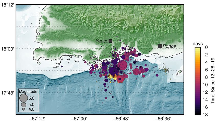
Figure 1: The figure above shows the distribution of relocated seismicity southwest of Puerto Rico in
December 2019 and January 2020. Earthquake symbols are sized by magnitude and colored according to
                        the time of the earthquake relative to December 28, 2019.

Seismicity Overview
Over the past several weeks, hundreds of small earthquakes have occurred offshore of
southwest Puerto Rico, beginning in earnest with a M 4.7 earthquake late on December 28.
Since the M 4.7 event, 66 earthquakes of magnitude 4 or larger have occurred (55 since current
mainshock), nine of which were M 5+ (6 since mainshock). At the magnitude 3 level, at which
earthquakes may be felt, our records are currently incomplete, though to date we have
recorded over 200 such events as part of this sequence (160 since the current mainshock). The
proximity of these events to Puerto Rico, and their shallow depth, mean that dozens of these
events have likely been felt on land.
Figure 2: Timeline of recent earthquake sequence in Puerto Rico during December 2019 and early January
                      2020. Each symbol represents an earthquake sized by magnitude.

Tectonics Overview
Tectonics in Puerto Rico (Figure 3, below) are dominated by the convergence between the
North America and Caribbean plates, with the island being squeezed between the two. The
convergence between these two plates occurs at a rate of about 20 mm/yr (about half the rate
that fingernails grow) in a east-northeast to west-southwest direction. To the north of Puerto
Rico, North America subducts beneath the Caribbean plate along the Puerto Rico trench. To the
south of the island, and south of this sequence, Caribbean plate lithosphere subducts beneath
Puerto Rico at the Muertos Trough. Several recent studies have documented upper plate
extension surrounding Puerto Rico – both to the east, in the Anagada passage, and to the west
in the Mona passage, such that Puerto Rico appears to be moving slowly westward with respect
to the Caribbean, and southern Puerto Rico moves slowly to the southwest with respect to the
north of the island.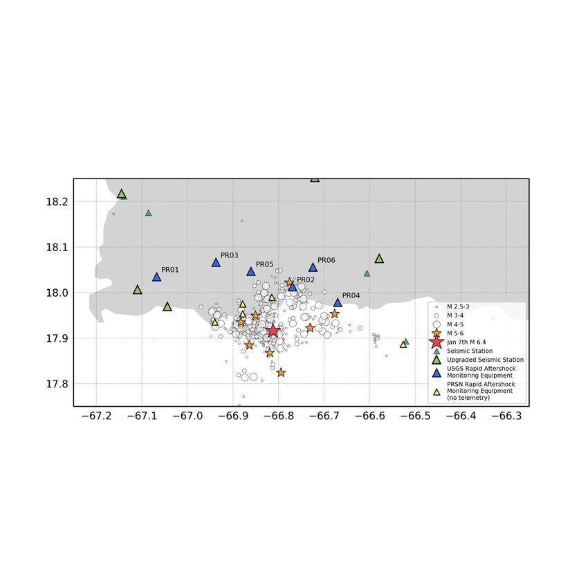
Figure 3: 20th and 21st century seismicity and plate boundaries in the northeastern Caribbean. Historic
earthquakes (circles) are colored by depth and sized by magnitude. The red star marks the location of the
January 7, 2020, M 6.4 earthquake.
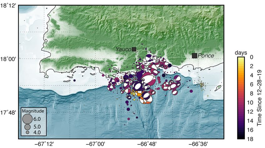
Earthquakes in this sequence are occurring in the offshore deformation zone bound by the
Punta Montalva Fault on land and the Guayanilla Canyon offshore. Earthquake locations and
focal mechanism solutions (Figure 4 below), which provide information about the type of
faulting involved in an earthquake, indicate that multiple fault structures have been activated in
this sequence – both strike-slip, and normal faults. This is an intraplate setting - that is, within
the crust of the Caribbean plate, rather than on the nearby plate boundary.
Large intraplate earthquakes in this region are not unexpected, though they occur infrequently,
particularly given the slow convergence between the major tectonic plates and the even slower
documented upper plate extension surrounding Puerto Rico.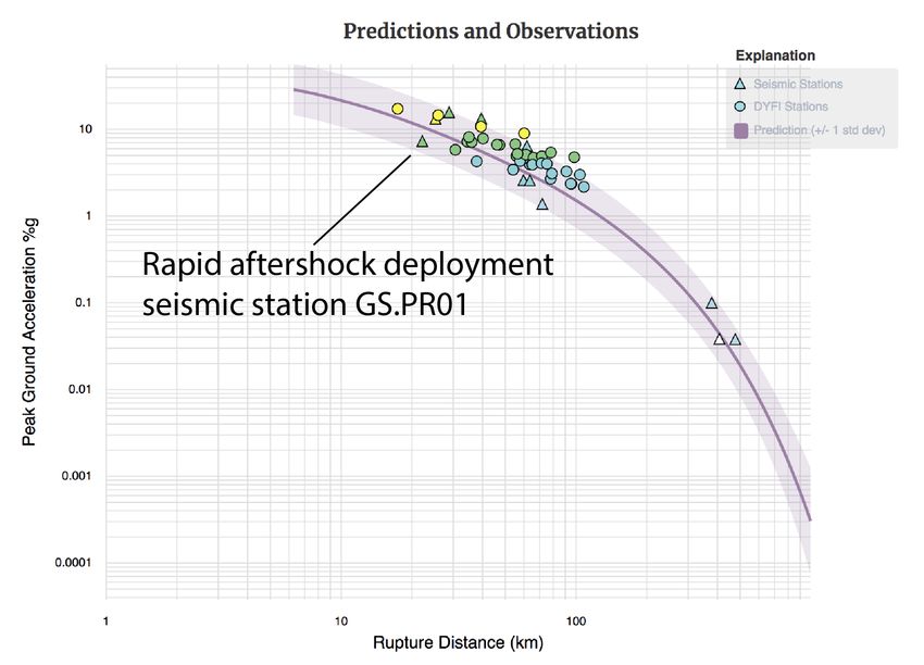
Figure 4: The figure above shows the distribution of relocated sequence seismicity overlain with focal
mechanism solutions (beachballs), indicating the type of faulting in each event. Earthquake symbols are
sized by magnitude and colored according to the time of the earthquake relative to December 28, 2019.

Earthquake Relocations
Single event earthquake locations are improved upon through a multiple event relocation
technique called hypocentroidal decomposition. Multiple event relocation techniques improve
the accuracy of both absolute and relative locations over standard methods. Uncertainty
estimates for these events are estimated to be about 2-3 km laterally and in depth.
Observations from rapidly deployed seismic stations can be tied into sequence relocations,
further improving the accuracy of relocations. Earthquake depths range from ~10-20 km below
mean sea-level.

Aftershock Forecast
Earthquake forecasts are created using a statistical analysis based on past earthquakes and are
presented in terms of probabilities of earthquakes of a given size occurring. The earthquake
forecast continues to be updated based on observations of the rate and size of earthquakes in
in this sequence. Details of the current aftershock forecast can be found here. It is important to
note that it is not possible to predict earthquakes, and earthquake forecasts are presented as
probabilities. Therefore, it is important to always remain prepared for more shaking.

Rapid Instrumentation Deployment
In response to the M6.4 Indios, Puerto Rico earthquake, the USGS and PRSN rapidly deployed
seismic instrumentation to record near-source aftershock ground motions from the evolving
sequence. As of January 13, PRSN has installed 5 stand-alone stations and the USGS has
installed 6 real-time stations (Figure 5 below). Seismic data from the USGS deployment will
stream in real-time to the USGS ANSS and PRSN for improved monitoring of the evolving
earthquake sequence and the threat and hazard posed to the people and property in Puerto
Rico from earthquakes and tsunami.
Figure 5: The map above shoes seismicity (circles and stars) and seismic monitoring stations (triangles).
                       Planned seismic stations are shown with transparency.

The portable seismic station deployment will supplement the permanent earthquake
monitoring operations of the USGS Advanced National Seismic System (ANSS) and Puerto Rico
Seismic Network (PRSN). In response to damage related to Hurricane Maria, the USGS and PRSN
have upgraded and hardened 11 seismic stations across Puerto Rico. Within the coming months
an additional 14 will also be upgraded. The data from these upgraded systems is shared in real-
time between PRSN, USGS NEIC and the NOAA tsunami warning system.

Near-Source Ground Motions
Near-source (
Figure 6: Instrumental and Did You Feel It? ground motion observations of the January 11, 2020 M 5.9
earthquake. Rapidly deployed aftershock station (GS.PR01) is the closest station to the earthquake at a
hypocentral distance of 22km.
Built Stock Vulnerability and Impact
Unlike the continental United States, the building stock in Puerto Rico is composed of a high
percentage (> 90%) of vulnerable construction such as reinforced concrete frames and
unreinforced masonry buildings. Earthquake-resistant wood frame construction, which is most
common in the continental US, represent only 5% of the total building stock. Given the extent
of vulnerable construction of this region, the USGS PAGER system estimated an orange alert
(direct shaking related losses exceeding 100 million USD, and a potential for some casualties)
from this earthquake.
Ongoing USGS Response and Next Steps
• In coordination with PRSN, the USGS have deployed six aftershock monitoring stations
near the source zone of these earthquakes. Observations from these stations improve
location estimates of these events. Ground-motion observations from these stations can
be incorporated into ground-motion prediction equations, which are fundamental toimproving regional seismic hazard assessment and subsequently building code. Strong
ground motions from these rapidly deployed stations have already captured a M 5.9
aftershock.
• USGS personnel are in the field to assess ground failure in the form of coseismic
liquefaction and landslides.
• USGS personnel are also on site with FEMA at the Joint Field Office to provide scientific
and communications support during earthquake response efforts.
Useful Links to USGS Impact Products and Information
USGS Top Story on the Indios, Puerto Rico Earthquake Earthquake Sequence
https://www.usgs.gov/news/magnitude-64-earthquake-puerto-rico
M 6.4 Event
https://earthquake.usgs.gov/earthquakes/eventpage/us70006vll/executive
Impact Assessment (PAGER)
https://earthquake.usgs.gov/earthquakes/eventpage/us70006vll/pager
Aftershock Forecast
https://earthquake.usgs.gov/earthquakes/eventpage/us70006vll/oaf/commentary
Ground Failure Modeling
https://earthquake.usgs.gov/earthquakes/eventpage/us70006vll/ground-
failure/summary
Caribbean Tectonic Information and Summary
https://earthquake.usgs.gov/earthquakes/eventpage/us70006vll/region-infoYou can also read