Making cities Economies of production and urbanization in Mediterranean Europe, 1000-500 bc - Cambridge Repository
←
→
Page content transcription
If your browser does not render page correctly, please read the page content below
McDONALD INSTITUTE CONVERSATIONS

Making cities
Economies of production and
urbanization in Mediterranean
Europe, 1000–500 bc

Edited by Margarita Gleba,
Beatriz Marín-Aguilera
& Bela Dimova
Making cities
McDONALD INSTITUTE CONVERSATIONS

Making cities
Economies of production and
urbanization in Mediterranean
Europe, 1000–500 bc

Edited by Margarita Gleba,
Beatriz Marín-Aguilera & Bela Dimova

with contributions from
David Alensio, Laura Álvarez, Giovanna Bagnasco Gianni, William Balco,
Lesley Beaumont, Jeffrey Becker, Zisis Bonias, Simona Carosi, Letizia
Ceccarelli, Manuel Fernández-Götz, Eric Gailledrat, Giovanna Gambacurta,
David Garcia i Rubert, Karina Grömer, Javier Jiménez Ávila, Rafel Journet,
Michael Kolb, Antonis Kotsonas, Emanuele Madrigali, Matilde Marzullo,
Francesco Meo, Paolo Michelini, Albert Nijboer, Robin Osborne, Phil
Perkins, Jacques Perreault, Claudia Piazzi, Karl Reber, Carlo Regoli,
Corinna Riva, Andrea Roppa, Marisa Ruiz-Gálvez, Joan Sanmartí Grego,
Christopher Smith, Simon Stoddart, Despoina Tsiafaki, Anthony Tuck,
Ioulia Tzonou, Massimo Vidale & Jaime Vives-Ferrándiz Sanchez
Published by:
McDonald Institute for Archaeological Research
University of Cambridge
Downing Street
Cambridge, UK
CB2 3ER
(0)(1223) 339327
eaj31@cam.ac.uk
www.mcdonald.cam.ac.uk
McDonald Institute for Archaeological Research, 2021
© 2021 McDonald Institute for Archaeological Research.
Making cities is made available under a Creative Commons
Attribution-NonCommercial-NoDerivatives 4.0 (International)
Licence: https://creativecommons.org/licenses/by-nc-nd/4.0/
ISBN: 978-1-913344-06-1
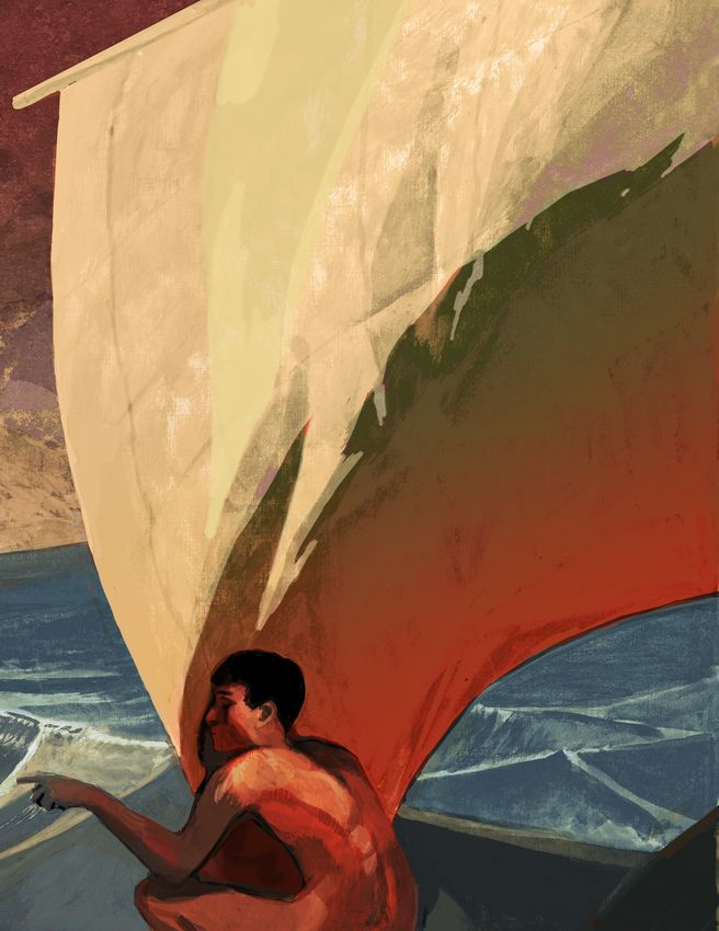
On the cover: Urbanization of Mediterranean Europe powered by sails, by Kelvin Wilson.
Cover design by Dora Kemp and Ben Plumridge.
Typesetting and layout by Ben Plumridge.
Edited for the Institute by Cyprian Broodbank (Acting Series Editor).Contents
Contributorsix
Figuresxiii
Tablesxvii
Chapter 1 Making cities: economies of production and urbanization in Mediterranean Europe,
1000–500 bc1
Bela Dimova, Margarita Gleba & Beatriz Marín-Aguilera
Definitions of urbanism 2
Urbanism and textiles 2
Contributions to this volume 3
Cover illustration 4
Part I Eastern Mediterranean
Chapter 2 Argilos: the booming economy of a silent city 9
Jacques Perreault & Zisis Bonias
Chapter 3 Regional economies and productions in the Thermaic Gulf area 21
Despoina Tsiafaki
Thermaic Gulf economies and production 22
Ancient Therme and its harbour 26
Conclusion 34
Chapter 4 Production activities and consumption of textiles in Early Iron Age Eretria 39
Karl Reber
Eretria in the Early Iron Age 39
Eretria’s economic situation 41
The production and consumption of textiles 41
Conclusion 45
Chapter 5 Productive economy and society at Zagora 47
Lesley A. Beaumont
Chapter 6 Making Cretan cities: urbanization, demography and economies of production in the
Early Iron Age and the Archaic period 57
Antonis Kotsonas
Urbanization 58
Demography 66
Economies of production 69
Conclusion 71
Chapter 7 Production, urbanization, and the rise of Athens in the Archaic period 77
Robin Osborne
Chapter 8 Making Corinth, 800–500 bc: production and consumption in Archaic Corinth 89
Ioulia Tzonou
Eighth century, to the end of the Geometric period and the transition into the Early
Protocorinthian, 720 bc95
Seventh century, the Protocorinthian and Transitional period into Early Corinthian, 720–620 bc97
Sixth century, the Corinthian period, 620–500 bc98
Conclusion 100
vPart II Central Mediterranean
Chapter 9 Making cities in Veneto between the tenth and the sixth century bc107
Giovanna Gambacurta
Urbanization criteria 107
Landscape and population 109
Settlements 110
Necropoleis 111
Borders and shrines 112
Inscriptions 114
Myths 115
Conclusion 116
Chapter 10 Attached versus independent craft production in the formation of the early city-state
of Padova (northeastern Italy, first millennium bc)123
Massimo Vidale & Paolo Michelini
Materials and methods 124
General patterns of industrial location 126
Methodological issues 128
The craft industries through time 130
New craft locations: size and size variations through time 131
Duration of urban craft workshops 132
Ceramic, copper and iron processing sites: size versus duration of activities 133
Discussion 134
A historical reconstruction 138
Onset of proto-currency and the issue of remuneration 141
Conclusion 142
Chapter 11 Resource and ritual: manufacturing and production at Poggio Civitate 147
Anthony Tuck
Chapter 12 Perugia: the frontier city 161
Letizia Ceccarelli & Simon Stoddart
Geology and culture 161
History of research 163
The emerging city from the rural landscape 165
The topographical development of the city 166
The city and its hinterland 168
The rural settlements associated with the city 169
Conclusion 172
Chapter 13 Tarquinia: themes of urbanization on the Civita and the Monterozzi Plateaus 177
Giovanna Bagnasco Gianni, Matilde Marzullo & Claudia Piazzi
Approaching themes of urbanization at Tarquinia 177
On the positioning of the protostoric site of Calvario and its road links 178
The Calvario village on the Monterozzi Plateau and its economic activities during the eighth
century bc 180
The process of urbanization based on the evidence for the fortifications 185
The limits of Tarquinia before its fortification, a theoretical approach 188
Chapter 14 Prolegomena to the material culture of Vulci during the Orientalizing period in the
light of new discoveries 195
Simona Carosi & Carlo Regoli
New data from Poggio Mengarelli Necropolis 195
Conclusion 202
viMaking cities: economies of production and urbanization in Mediterranean Europe, 1000–500 bc
Chapter 15 Defining space, making the city: urbanism in Archaic Rome 205
Jeffrey A. Becker
Making civic space – the Forum Romanum and its environs 206
Monumentality 210
Peri-urban evidence 211
Discussion 214
Chapter 16 Commodities, the instability of the gift, and the codification of cultural encounters
in Archaic southern Etruria 219
Corinna Riva
Agricultural surplus and a new funerary ideology 220
Oversize vessels and fixing the gift 221
Codification in the encounter 222
Conclusion 226
Chapter 17 The Etruscan pithos revolution 231
Phil Perkins
The pithos as artefact 232
Making pithoi 236
Using pithoi 240
Socio-economic agency of pithoi 243
Pithoi, economic development, and inequality 245
Pithoi, economic growth and cities 248
Conclusion 250
Chapter 18 Birth and transformation of a Messapian settlement from the Iron Age to the Classical
period: Muro Leccese 259
Francesco Meo
The Iron Age village 259
The Archaic and Classical settlement 266
The Hellenistic period and the end of the town 276
Chapter 19 Indigenous urbanism in Iron Age western Sicily 281
Michael J. Kolb & William M. Balco
Settlement layout 282
Demographic changes 286
Production, consumption and exchange 288
Ritual and cultic activity 290
Conclusion 291
Part III Western Mediterranean
Chapter 20 Colonial production and urbanization in Iron Age to early Punic Sardinia
(eighth–fifth century bc)299
Andrea Roppa & Emanuele Madrigali
Colonial production and amphora distribution in Iron Age Sardinia 299
Case studies: Nora and S’Urachi 301
Discussion 305
Colonial economies and urbanization 309
Chapter 21 Entanglements and the elusive transfer of technological know-how, 1000–700 bc:
elite prerogatives and migratory swallows in the western Mediterranean 313
Albert J. Nijboer
Movement of peoples and goods 314
Iron 316
The alphabet 319
Early monumental architecture 321
Discussion and epilogue 323
viiChapter 1
Chapter 22 Making cities, producing textiles: the Late Hallstatt Fürstensitze329
Manuel Fernández-Götz & Karina Grömer
Monumentality, production and consumption: the settlement evidence 330
Textile use and display in funerary contexts 336
Conclusion 340
Chapter 23 From household to cities: habitats and societies in southern France during the Early Iron Age 345
Éric Gailledrat
A question of time 346
A contrasted image 347
From one Mediterranean to another 348
The evanescent settlement 349
The emergence of the fortified group settlement 351
The oppida of the sixth–fifth centuries bc 354
The house in the context of the group settlement 358
Craftspeople, crafts and workshops 361
Conclusion 363
Chapter 24 Urbanization and early state formation: elite control over manufacture in Iberia
(seventh to third century bc) 367
Joan Sanmartí, David Asensio & Rafel Jornet
The historical process 367
Craft in its social context 369
Conclusion 380
Chapter 25 Productive power during the Early Iron Age (c. 650–575 bc) at the Sant Jaume Complex
(Alcanar, Catalonia, Spain) 385
Laura Álvarez, Mariona Arnó, Jorge A. Botero, Laia Font, David Garcia i Rubert,
Marta Mateu, Margarita Rodés, Maria Tortras, Carme Saorin & Ana Serrano
The Sant Jaume Complex 385
Production in the Sant Jaume Complex chiefdom 388
Conclusion 392
Chapter 26 Not all that glitters is gold: urbanism and craftspeople in non-class or non-state run societies 395
Marisa Ruiz-Gálvez
Craftspeople and workshops in Iberia 395
Workshops in Iberia 398
The Iberians as a House Society 400
Conclusion 404
Chapter 27 Urbanization and social change in southeast Iberia during the Early Iron Age 409
Jaime Vives-Ferrándiz Sánchez
Iberian urbanization: connectivity and dispersed territories 409
Local economies into broader networks 411
Agricultural intensification 412
Urbanization, institutions and political authority 415
Conclusion 420
Chapter 28 ‘Building palaces in Spain’: rural economy and cities in post-Orientalizing Extremadura 425
Javier Jiménez Ávila
Cancho Roano as a phenomenon 429
The ‘post-Orientalizing’ world 432
Post-Orientalizing economies 432
Countryside and cities 438
Final remarks 440
Part IV Conclusion
Chapter 29 Craft and the urban community: industriousness and socio-economic development 447
Christopher Smith
viiiContributors
David Alensio Letizia Ceccarelli
Departament de Prehistòria, Història Antiga Department of Chemistry, Materials and Chemical
i Arqueologia, Universitat de Barcelona, C/ Engineering ‘G.Natta’, Politecnico di Milano, Piazza
Montalegre 6-8, 08001 Barcelona, Spain Leonardo da Vinci 32, 20133 Milano, Italy
Email: davidasensio@ub.edu Email: letizia.ceccarelli@polimi.it
Laura Álvarez Estapé Bela Dimova
Independent scholar British School at Athens, Souidias 52, Athens 10676,
Email: laura.alvarezestape@gmail.com Greece
Email: bela.dimova@bsa.ac.uk
Giovanna Bagnasco Gianni
Dipartimento di Beni Culturali e Ambientali, Manuel Fernández-Götz
Università degli Studi di Milano, via Festa del School of History, Classics and Archaeology,
Perdono 7, 20122 Milano, Italy University of Edinburgh, William Robertson Wing,
Email: giovanna.bagnasco@unimi.it Old Medical School, Teviot Place, Edinburgh,
EH8 9AG, UK
William Balco Email: M.Fernandez-Gotz@ed.ac.uk
Department of History, Anthropology, and
Philosophy, University of North Georgia, Barnes Eric Gailledrat
Hall 327, Dahlonega, GA 30597, USA CNRS, Archéologie des Sociétés Méditerranéennes,
Email: william.balco@ung.edu UMR 5140, Université Paul Valéry-Montpellier 3,
F-34199, Montpellier cedex 5, France
Lesley Beaumont Email: eric.gailledrat@cnrs.fr
Department of Archaeology, Faculty of Arts & Social
Sciences, The University of Sydney, A18, Sydney, Giovanna Gambacurta
NSW 2006, Australia Dipartimento di Studi Umanistici, Università Ca’
Email: lesley.beaumont@sydney.edu.au Foscari Venezia, Palazzo Malcanton Marcorà,
Dorsoduro 3484/D, 30123 Venezia, Italy
Jeffrey Becker Email: giovanna.gambacurta@unive.it
Department of Middle Eastern and Ancient
Mediterranean Studies, Binghamton University – David Garcia I Rubert
State University of New York, 4400 Vestal Parkway Departament de Prehistòria, Història Antiga i
East, PO Box 6000, Binghamton, NY 13902-6000, Arqueologia, Universitat de Barcelona, Carrer
USA Montalegre 6, 08001 Barcelona, Spain
Email: beckerj@binghamton.edu Email: dgarciar@ub.edu
Zisis Bonias Margarita Gleba
Ephorate of Antiquities of Kavala-Thasos, Erythrou Dipartimento dei Beni Culturali, Università degli
Stavrou 17, Kavala 65110, Greece Studi di Padova, Piazza Capitaniato 7, Palazzo
Email: zbonias@yahoo.gr Liviano, 35139 Padova, Italy
Email: margarita.gleba@unipd.it
Simona Carosi
Soprintendenza Archeologia Belle Arti e Paesaggio Karina Grömer
per l’area metropolitana di Roma, la provincia di Natural History Museum Vienna, Department of
Viterbo e l’Etruria meridionale, Palazzo Patrizi Prehistory, Burgring 7, 1010 Vienna, Austria
Clementi, via Cavalletti n.2, 00186 Roma, Italy Email: karina.groemer@nhm-wien.ac.at
Email: simona.carosi@beniculturali.it
ixJavier Jiménez Ávila Albert Nijboer
Consejería de Cultura, Turismo y Deporte – Junta Groningen Institute of Archaeology, Poststraat 6,
de Extremadura, Edificio Tercer Milenio, Módulo 4, 9712 ER Groningen, The Netherlands
Avda. de Valhondo s/n, 06800 Mérida, Spain Email: a.j.nijboer@rug.nl
Email: jjimavila@hotmail.com
Robin Osborne
Rafel Journet University of Cambridge, Faculty of Classics,
Departament de Prehistòria, Història Antiga Sidgwick Avenue, Cambridge CB3 9DA, UK
i Arqueologia, Universitat de Barcelona, C/ Email: ro225@cam.ac.uk
Montalegre 6-8, 08001 Barcelona, Spain
Email: rafeljornet@ub.edu Phil Perkins
Classical Studies, School of Arts & Humanities,
Michael Kolb The Open University, Perry C Second Floor, 25,
Department of Sociology and Anthropology, Walton Hall, Milton Keynes MK7 6AA, UK
Metropolitan State University of Denver, Campus Email: Phil.Perkins@open.ac.uk
Box 19, P.O. Box 173362, Denver, CO 80217-3362,
USA Jacques Perreault
Email: mkolb5@msudenver.edu Université de Montréal C.P. 6128, Succursale
Centre-Ville Montréal, QC, H3C 3J7, Canada
Antonis Kotsonas Email: jacques.y.perreault@umontreal.ca
Institute for the Study of the Ancient World, New
York University, 15 East 84th St., New York, NY Claudia Piazzi
10028, USA Coordinating Research Centre ‘Tarquinia Project’,
Email: ak7509@nyu.edu Dipartimento di Beni Culturali e Ambientali,
Università degli Studi di Milano, via Festa del
Emanuele Madrigali Perdono 7, 20122 Milano, Italy
Independent scholar Email: claudia.piazzi2@gmail.com
Email: e.madrigali@gmail.com
Karl Reber
Beatriz Marín-Aguilera Université de Lausanne, Anthropole 4011, 1015
McDonald Institute for Archaeological Research, Lausanne, Switzerland
University of Cambridge, Downing Street, Email: karl.reber@unil.ch
Cambridge CB2 3DZ, UK
Email: bm499@cam.ac.uk Carlo Regoli
Fondazione Vulci, Parco Naturalistico Archeologico
Matilde Marzullo di Vulci, 01014 Montalto di Castro (Viterbo), Italy
Coordinating Research Centre ‘Tarquinia Project’, Email: caregoli@gmail.com
Dipartimento di Beni Culturali e Ambientali,
Università degli Studi di Milano, via Festa del Corinna Riva
Perdono 7, 20122 Milano, Italy Institute of Archaeology, University College
Email: matilde.marzullo@unimi.it London, 31–34 Gordon Square, London
WC1H 0PY, UK
Francesco Meo Email: c.riva@ucl.ac.uk
Dipartimento di Beni Culturali, Università del
Salento, Via D. Birago, 64, 73100 Lecce, Italy Andrea Roppa
Email: francesco.meo@unisalento.it Independent scholar
Email: roppaandrea@gmail.com
Paolo Michelini
P.ET.R.A., Società Cooperativa ARL, Via Matera, 7 Marisa Ruiz-Gálvez
a/b, 35143 Padova, Italy Departamento de Prehistoria, Historia Antigua y
Email: paolo.mik@libero.it Arqueología, Universidad Complutense de Madrid,
Edificio B C/ Profesor Aranguren, s/n Ciudad
Universitaria, 28040 Madrid, Spain
Email: marisar.gp@ghis.ucm.es
xJoan Sanmartí Grego Anthony Tuck
Departament de Prehistòria, Història Antiga i Department of Classics, University of Massachusetts
Arqueologia, Universitat de Barcelona, Carrer Amherst, 524 Herter Hall, 161 Presidents Drive
Montalegre 6, 08001 Barcelona, Spain Amherst, MA 01003, USA
Email: sanmarti@ub.edu Email: atuck@classics.umass.edu
Christopher Smith Ioulia Tzonou
School of Classics, University of St Andrews, Fife Corinth Excavations, American School of Classical
KY16 9AL, UK Studies at Athens, Ancient Corinth 20007, Greece
Email: cjs6@st-and.ac.uk Email: itzonou.corinth@ascsa.edu.gr
Simon Stoddart Massimo Vidale
Department of Archaeology, University of Dipartimento dei Beni Culturali, Università degli
Cambridge, Downing Street, Cambridge Studi di Padova, Piazza Capitaniato 7, Palazzo
CB2 3DZ, UK Liviano, 35139 Padova, Italy
Email: ss16@cam.ac.uk Email: massimo.vidale@unipd.it
Despoina Tsiafaki Jaime Vives-Ferrándiz Sanchez
Culture & Creative Industries Department, ‘Athena’: Museu de Prehistòria de València
Research & Innovation Center in Information, Email: jaime.vivesferrandiz@dival.es
Communication & Knowledge Technologies.
Building of ‘Athena’ R.C., University Campus of
Kimmeria, P.O. Box 159, Xanthi 67100, Greece
Email: tsiafaki@ipet.gr
xiFigures
1.1 Map indicating the volume coverage. 4
2.1 Argilos, aerial view.
10
2.2 Argilos, general plan. 10
2.3 Small furnace in building E. 11
2.4 View of building L.
12
2.5 Plan of Koutloudis area with buildings H, L, P, and Q. 13
2.6 Building L, press-bed in room 4. 13
2.7 Building Q, room 1. 14
2.8 Building L, room 11, crushed amphorae. 16
2.9 Dividing wall between L7–L8 with remains of clay over the lower courses of stone. 17
2.10 Building L, facades of L2–L3. 18
3.1 Thermaic Gulf region. 22
3.2 Iron sword, grave offering, Nea Philadelphia cemetery, late sixth century bc. 24
3.3 Miniature iron wagon, grave offering, Sindos cemetery, late sixth century bc. 25
3.4 Methone. Pottery kilns in Building A at Sector B. 26
3.5 Ancient settlement at Karabournaki, aerial view. 27
3.6 Ancient settlement at Karabournaki, storeroom with pithoi. 28
3.7 ‘Eggshell’ type vases made at the pottery workshop at Karabournaki. 29
3.8 Karabournaki settlement metal workshop. 30
3.9 Weaving tools from the Karabournaki settlement. 31
3.10 Loom weight with stamp depicting a satyr, Karabournaki settlement. 32
3.11 Karabournaki: distribution of textile production tools within the excavated area.
33
4.1 Map of Geometric Eretria. 40
4.2 Plan of the Sanctuary of Apollo in the eighth century bc. 40
4.3 Spindle whorl with dedication, from the Sanctuary of Apollo. 42
4.4 Cruche à haut col C41 (tankard) from the Aire sacrificielle. 42
4.5 Cruche à haut col C37 (tankard) from the Aire sacrificielle. 43
4.6 Fragment of linen from Grave 10 in the Heroon Necropolis. 44
4.7 Close-ups of wool weft-faced textiles from the Heroon Necropolis. 45
5.1 View of Zagora promontory from the northeast. 48
5.2 Plan of Zagora. 49
5.3 Aerial view of Trench 11, partially excavated.
52
6.1 Map of Crete showing sites mentioned in the text. 58
6.2 Plan of Karphi. 59
6.3 Plan of the Knossos valley. 62
6.4 Plan of Prinias. 64
6.5 Plan of Azoria. 65
6.6 Knossos North Cemetery: maximum and minimum number of cremation urns over time. 68
6.7 Knossos North Cemetery: number of cremation urns per year. 68
6.8 Fortetsa Cemetery: number of burials over time. 68
6.9 Fortetsa Cemetery: number of burials per year. 68
6.10 Reconstruction of the pottery workshop at Mandra di Gipari, near Prinias. 70
7.1 Attica, 1050–900 bc. 80
7.2 Attica, 900–800 bc. 80
7.3 Attica, 800–700 bc. 81
7.4 Attica, 700–600 bc. 81
7.5 Attica, 600–500 bc. 85
8.1 Map of the northeast Peloponnese showing sites mentioned in the text. 90
8.2 Corinth: Geometric Period multiphase plan (900–720 bc). 91
8.3 Corinth: Protocorinthian to Transitional Period multiphase plan (720–620 bc). 91
8.4 Corinth: Corinthian Period multiphase plan (620–500 bc). 92
8.5 Corinth: fifth century bc multiphase plan. 93
xiii8.6 Corinth: multiphase plan up to 400 bc. 93
8.7 Corinth: Forum, all periods. 94
8.8 South Stoa, Tavern of Aphrodite Foundry. 99
8.9 Late Corinthian kraters from the sixth-century bc floor. 101
8.10 The Arachne aryballos, Late Early Corinthian or Middle Corinthian (600 bc). 102
9.1 Maps of Veneto. 108
9.2 Maps of cities with different orientations: a) Oderzo; b) Padova. 110
9.3 Este, clay andirons with ram’s heads. 112
9.4 Padova, funerary stone monuments: a) Camin; b) Albignasego. 112
9.5 Padova, via Tadi, boundary stone with Venetic inscription on two sides. 114
9.6 Padova, via C. Battisti, boundary stone with Venetic inscription on four sides. 114
9.7 Padova, via Tiepolo–via San Massimo 1991, Grave 159, bronze figured belt-hook. 115
9.8 Este, Casa di Ricovero, Grave 23/1993 or Nerka’s grave. 116
9.9 Isola Vicentina, stele with Venetic inscription. 117
10.1 Location of Padova and the study area in northeastern Italy. 124
10.2 Padova, general cumulative map of the craft locations, c. 825–50 bc. 125
10.3 Padova, location of the craft areas and workshops in the early urban core. 127
10.4 Padova, the extra-urban location of craft industries in Roman times. 129
10.5 New manufacturing areas per different craft. 131
10.6 Maximum total area occupied by craft production sites. 132
10.7 New craft areas activated in each period. 132
10.8 Frequency distribution of dimensional class of craft areas per period.
132
10.9 Padova, Questura, site 2, northeast sector. 133
10.10 Workshop size and duration of activity. 134
10.11 Padova, Questura, site 2. Ceramic tuyère. 136
10.12 Padova, Questura, site 2. Cluster of fine feasting pottery. 137
10.13 Padova, Questura, site 2. Antler combs from the metallurgical workshop. 137
10.14 Sherds of Attic pottery from workshop areas in Padova. 138
10.15 Padova, Piazza Castello, site 3: vertical kiln and modular perforated grid. 139
10.16 Part of an elite grave’s furnishings from Padova, end of the eighth century bc. 140
10.17 Vessels from the cemetery of Piovego, Padova, fifth century bc. 141
11.1 Map of central Italy. 148
11.2 Early Phase Orientalizing Complex Building 4 (c. 725–675 bc) reconstruction. 148
11.3 Orientalizing Complex (c. 675–600 bc) reconstruction. 149
11.4 Archaic Phase Structure (c. 600–530 bc) reconstruction. 149
11.5 Orientalizing Complex roofing elements. 150
11.6 Partially worked and complete bone, antler and ivory. 150
11.7 Unfired cover tiles with human footprints. 151
11.8 Distribution of variable sized spindle whorls. 152
11.9 Carbonized seeds from Orientalizing Complex Building 2/Workshop. 153
11.10 Fragment of statuette from Orientalizing Complex Building 2/Workshop. 153
11.11 Frieze plaque depicting banqueting scene, Archaic Phase Structure. 155
11.12 Elements of a banquet service from the Orientalizing Complex. 155
11.13 Compote with incised khi. 156
11.14 Map of Poggio Civitate and surrounding traces of settlements or other human activity.
157
12.1 Location of Perugia. 162
12.2 The immediate environs of Perugia with key sites. 162
12.3 The geological context of Perugia. 163
12.4 Plan of the city of Perugia. 166
12.5 Hierarchical relationship of Perugia to its territory. 169
12.6 Civitella d’Arna survey area. 171
12.7 Montelabate survey area. 172
13.1 Positioning of the structures of the Calvario. 179
13.2 Tarquinia and its territory around the middle of the eighth century bc. 180
xiv13.3 Plan of the Villanovan village on the Monterozzi Plateau. 181
13.4 Plans of some of the Villanovan huts. 183
13.5 Finds from the huts. 184
13.6 Walls, gateways and roads of ancient Tarquinia. 185
13.7 Tarquinia, Bocchoris Tomb, lid. 189
14.1 Location of the excavation area at Vulci. 196
14.2 Aerial photograph of the excavation (2016–2018). 197
14.3 General plan of the excavation (2016–2018). 197
14.4 Textile fragment from the ‘Tomb of the Golden Scarab’. 198
14.5 Detail of the grave goods from Tomb 35 during excavation. 199
14.6 Tomb 29 during excavation. 200
14.7 Tomb 29: detail of the traces of cloth on the lid of the sheet bronze stamnos. 201
14.8 Tomb 72: a textile with colour pattern of small red and white checks. 202
15.1 Plan of Rome’s territory in the Archaic period. 206
15.2 Area of the Volcanal and the Comitium in the seventh and sixth centuries bc. 207
15.3 Reconstructed plan of Rome within the so-called ‘Servian Wall’. 208
15.4 Sketch plan of the area of the Forum Boarium and Velabrum in the seventh century bc. 210
15.5 Phase 1 of the so-called ‘Auditorium site’ villa. 212
15.6 Phase 2 of the so-called ‘Auditorium site’ villa. 212
15.7 The Republican ‘Villa delle Grotte’ at Grottarossa. 213
16.1 White-on-red pithos with lid, Cerveteri. 223
16.2 Figurative decoration of the Gobbi krater. 224
16.3 Black-figure amphora, Vulci, side A. 226
16.4 Black-figure amphora, Vulci, side B. 226
17.1 Pithos types 1–6. 233
17.2 Distribution map of Etruscan pithoi within the study area in Etruria. 240
17.3 Comparison between the altitude of pithos find spots and the range of altitude. 241
17.4 Map of sample area. 242
17.5 Distribution of architectural terracottas, pithoi, amphorae, and tiles. 249
18.1 Muro Leccese and the other Iron Age settlements in the Salento peninsula. 260
18.2 Muro Leccese, find spots of Early Iron Age and Archaic ceramics and structures. 261
18.3 Muro Leccese, Cunella district, traces of two huts. 262
18.4 Muro Leccese, DTM with location of the Iron Age ceramics and structures. 263
18.5 Vases and decorative motifs characteristic of matt-painted ware from Muro Leccese. 264
18.6 Vases imported from Greece and Greek apoikiai. 265
18.7 The Messapian era road network in the Salento peninsula. 267
18.8 Muro Leccese, Palombara district. 268
18.9 Muro Leccese, Palombara district. Vases. 270
18.10 Muro Leccese, Cunella district. Plan of the residential building. 272
18.11 Diorama of the place of worship in the archaeological area of Cunella. 273
18.12 Muro Leccese, Masseria Cunella district. Tombs 1 and 2. 274
18.13 Muro Leccese, fourth century bc walls. 275
19.1 Map of Sicily, showing the Bronze Age sites mentioned in the text. 282
19.2 The defensive wall at Bronze Age site of Mursia, Pantelleria. 283
19.3 The Late Bronze Age excavations at Mokarta. 283
19.4 Monte Bonifato, showing its steep approaches. 284
19.5 Map of western Sicily showing the Iron Age sites mentioned in the text. 284
19.6 The urban layout of Eryx. 285
19.7 The urban layout of Segesta. 286
19.8 The orthogonal grid and Iron Age/Classical/Hellenistic finds of Salemi. 287
19.9 The archaeological sites of Salemi territory. 287
19.10 The temple of Segesta, facing west. 291
20.1 Map of Sardinia showing sites mentioned in the text. 300
20.2 Plan of Nora and the Punic quarter under the forum. 301
xv20.3 Main amphora types discussed. 302
20.4 Dating profiles of amphora types. 303
20.5 Plan of nuraghe S’Urachi and cross-section of the ditch in area E. 304
20.6 Dating profile of the amphora types from the case study at nuraghe S’Urachi. 305
20.7 Dating profiles of Phoenician amphora types. 306
21.1 Early iron and the distribution of Huelva-Achziv type fibulae on the Iberian Peninsula. 317
21.2 Three copper alloy bowls dated to the decades around 800 bc. 319
21.3 The Phoenician, Euboean, Etruscan and Latin alphabetic letters. 320
21.4 Early monumental architecture in Italy and Spain. 322
21.5 Provenance of ceramics from the ninth century bc, pre-Carthage Utica (Tunis). 324
22.1 Fürstensitze north of the Alps and selected sites in Mediterranean Europe. 330
22.2 The Heuneburg agglomeration during the mudbrick wall phase. 331
22.3 Indicative lifespans of selected Fürstensitze sites. 331
22.4 Aerial view of the gatehouse of the Heuneburg lower town during the excavation. 332
22.5 Large ditch at the south foot of wall 3 at Mont Lassois.
333
22.6 Reconstructed monumental building in the Heuneburg Open-Air Museum. 334
22.7 Fired clay loom weight and spindle whorls from the Heuneburg. 335
22.8 Comparison between grave textiles and other textiles. 337
22.9 Tablet-woven band, reproduced after a textile from Hochdorf. 338
22.10 Functions of textiles in graves. 339
23.1 Map of the south of France showing the main settlements of the Early Iron Age. 346
23.2 Mailhac (Aude). 350
23.3 Examples of apsidal floorplans of wattle-and-daub (a) or cob houses (b–d). 352
23.4 Examples of rectangular floorplans of houses with one or more rooms. 353
23.5 Pech Maho (Sigean, Aude). 355
23.6 Examples of functional combinations of apsidal and rectangular floorplans. 356
23.7 Early examples of urban planning combining blocks of houses with a system of streets. 357
23.8 a–c) Examples of rectangular floorplans; d–e) houses of La Liquière. 359
23.9 Montlaurès (Narbonne, Aude). 360
24.1 Map of northern Iberia showing the sites mentioned in the text. 368
24.2 Pottery workshop of Hortes de Cal Pons. 371
24.3 Bases of Iberian amphorae. 372
24.4 Les Guàrdies (El Vendrell). 373
24.5 Castellet de Banyoles. 375
24.6 Mas Castellar de Pontós. 376
24.7 Coll del Moro de Gandesa. 378
24.8 Sant Antoni de Calaceit. 379
24.9 Els Estinclells.
380
25.1 General location of the area under study. 386
25.2 View of Sant Jaume. 387
25.3 Plan of Sant Jaume. 387
25.4 Aerial view of La Moleta del Remei. 389
25.5 Aerial view of La Ferradura. 389
26.1 Tumulus ‘A’ at Setefilla. 396
26.2 Sample of matrices and tools from the so-called goldsmith’s graves at Cabezo Lucero. 397
26.3 Iberian tombs with grave goods connected with weighing metal. 398
26.4 Spatial distribution of tools in rooms of Iberian oppida. 400
26.5 Iberian funerary pillars crowned by heraldic beasts. 402
26.6 Enthroned Iberian ladies: a) Cerro de los Santos; b) Baza. 403
26.7 Reconstructions: a) La Bastida de les Alcusses; b) El Castellet de Banyoles. 403
26.8 Bronze horseman from La Bastida de Les Alcusses and reconstruction as a sceptre. 404
27.1 Map of the study area showing the main sites mentioned in the text. 410
27.2 Metallurgical workshop at La Fonteta. 412
27.3 Plan of Alt de Benimaquia and local amphorae. 413
xvi27.4 Plan of El Oral. 414
27.5 The territory of El Puig d’Alcoi and the secondary rural settlements. 416
27.6 Different furnaces for iron metalwork from La Cervera. 416
27.7 Plans of walled settlements: a) Covalta; b) Puig d’Alcoi; c) La Bastida de les Alcusses. 417
27.8 Aerial view of the storerooms at La Bastida de les Alcusses. 418
27.9 Plan of Block 5 at La Bastida de les Alcusses. 419
27.10 Weapons ritually ‘killed’ in the West Gate, La Bastida de les Alcusses. 419
28.1 Cancho Roano: a) general plan; b–c) reconstructions of the external rooms. 426
28.2 Map of sites considered as post-Orientalizing palatial complexes. 427
28.3 La Mata. 428
28.4 Post-Orientalizing settlements: a,d) El Chaparral; b) La Carbonera; c) Los Caños. 431
28.5 Millstones and amphorae from post-Orientalizing sites in Middle Guadiana. 433
28.6 Storage building at the Orientalizing site of El Palomar, Oliva de Mérida. 434
28.7 Greek pottery from Cancho Roano, late fifth century bc. 436
28.8 Antique (sixth-century bc) goods in post-Orientalizing contexts. 437
28.9 The Orientalizing site of Medellín. 439
28.10 Ancient toponymy in southwestern Iberia. 440
Tables
7.1 Sites in Attica, late eleventh to seventh century bc. 78
8.1 Dates: abbreviations and chronology. 90
9.1 List of criteria for defining cities.
108
9.2 Inventory of houses and buildings with their shape, dimensions and chronology. 111
10.1 Variations through time of principal type of craft occupation. 128
10.2 Variations through time of the maximum area of all craft occupations. 129
10.3 Padova, average duration in years of the main craft occupations for each period. 129
10.4 Padova, the development of craft industries as monitored in 29 craft workshops. 130
10.5 Positive correlation between size and duration of activity of craft workshops. 134
10.6 The composition of funerary vessels in the earliest graves from Padova. 140
14.1 Types of tombs excavated at Poggio Mengarelli, Vulci (2016–2018). 196
17.1 Type 1. 234
17.2 Type 2. 234
17.3 Type 3. 235
17.4 Type 3A. 235
17.5 Type 3B. 235
17.6 Type 3C. 236
17.7 Type 4. 236
17.8 Type 5. 237
17.9 Type 6. 237
17.10 Chaîne opératoire of Etruscan pithos manufacture. 238
21.1 Number of iron artefacts per phase at Torre Galli (c. 950–850 bc). 318
xviiChapter 13
Tarquinia: themes of urbanization
on the Civita and the Monterozzi Plateaus
Giovanna Bagnasco Gianni, Matilde Marzullo & Claudia Piazzi
Approaching themes of urbanization at Tarquinia of the animal and plant realms (Bonghi Jovino 2010c;
(GBG) Bagnasco Gianni 2014c). The centrality of the cavity
in ritual is confirmed by the deposition of a child
We approach the theme of urbanization at the time with unusual features in a quadrangular area close
when three major research projects of the University of to it. Palaeoanthropological analyses revealed that the
Milan are in progress at Tarquinia within the broader child was about eight years old, encephalopathic and
‘Tarquinia Project’, and after circumspection of a num- epileptic; he was not sacrificed and clearly remained
ber of relevant results (Bagnasco Gianni 2012; Bagnasco the object of prolonged subsequent veneration. An
Gianni et al. 2017; 2018a). They concern the excavation Etruscan inscription dating three centuries later (end
of the ‘monumental complex’ and of the sanctuary of of the sixth century bc), found by the cavity, demon-
the Ara della Regina (Tarchna 1997; 1999; 2001; 2012) strates that the memory of his ritual deposition by the
on the Civita Plateau, the topographic exploration cavity was maintained over the centuries. Terela is the
of the area of the ancient city (Marzullo 2018), and Etruscan word corresponding to Latin prodigium and
phases of its necropoleis (Marzullo 2016; 2017). In this Greek teras (Bagnasco Gianni et al. 2019), which are
framework, we focus on the relationship between the both terms indicating an exceptional phenomenon,
Villanovan settlement of the Calvario ‘village’ on the immediately recalling the story of Tages. According
Monterozzi Plateau and the settlement on the Civita to a number of literary sources, Tages was a wise boy
Plateau, along with the spread of the city’s necropoleis. born already old, who all of a sudden sprang from
This is a reliable starting point for shedding light on the earth and, singing, taught Tarchon the basic principles
Tarquinian community’s choices in space organization of the Etrusca disciplina, the religion of the Etruscans.
at the city’s very beginnings, before the fortifications Tarchon, the legendary hero founder of Tarquinia,
were built in masonry and the chamber tombs of the was thought to be responsible for both the foundation
necropolis started to be painted during the Oriental- of the city and for the Etruscan religion, through the
izing period. legend of his miraculous meeting with Tages (Bagnasco
This stage of the history of Tarquinia corresponds Gianni et al. 2019).
to the very ‘making of the city’ and the ‘monumental The history of this sacred area is crucial for under-
complex’ represents its real core since the beginning standing the social and institutional changes that took
of the Villanovan period (from the late tenth to the place within the Tarquinian community over time. The
eighth century bc). People gathered around a natural building of a temple-altar constructed at the beginning
cavity, a sinkhole produced by the calcareous rocks of the seventh century bc marked an important turn-
of the Civita Plateau, and intensively frequented the ing point in the layout of the natural cavity and in its
area probably at its wider extent (Bagnasco Gianni related cultic practices. Its technical features are inspired
2018). The quality of the offerings around the cav- by eastern Mediterranean masonry, murs a piliers or
ity indicates an unnamed divinity of nature, who pilaster walls, used to build the ‘monumental complex’.
started as a natural force and was endowed over time It represents the built version of the cultic area of the
with new characteristics, partly through contact with Villanovan period. The constellation of bronze objects
other populations of the Mediterranean. She became (lituus, axe, shield), discovered in front of the temple-
increasingly recognizable as a divinity of the life cycle altar, points to the political and religious role of the
177Chapter 13
individual, a king-priest. He dedicated the renovated This is also a particular feature of the ‘making’ of the
‘monumental complex’ to the great goddess, whose Etruscan cities in general. They have their own story
veneration began in that very spot as the natural force and are tightly connected to their geological and geo-
of the cavity. She is a ‘polysemic deity’, who surfaces graphic conditions. The study of their limits, space
through different levels of her anthropomorphization. organization choices, relationship with the territory
Her gifts show that she was influenced by multifaceted and the sea, has to consider symbolic and religious
contact with Mediterranean goddesses such as Uni – beliefs connected to the perception of the very nature
Ilizia – Ishtar, as documented in the sanctuary at Pyrgi, of their environment.
where she is supported by the presence of Herakles. It
is likely in this form that she received the dedication On the positioning of the protostoric site of
of the temple-altar by the king-priest (Bonghi Jovino Calvario and its road links (MM)
2010c). Shortly after, the goddess is referred to as Uni
in the inscription mi uni, dated at the end of the seventh The recent creation of the GIS of the Archaeologi-
century bc. She continues safeguarding this crucial site cal Map of the Civita di Tarquinia allows for a more
where various elements address the principles of the defined contextualization of the discoveries made
Etrusca Disciplina: the recent discovery of the inscrip- in the territory around the town. Among these, is
tion xiiati, on an impasto jar (of sixth–fifth century bc), the so-called ‘protohistoric village’ of Calvario. The
meaning ‘related to Xia’, ‘Xia mother’, or ‘Xia and a topographical positioning of the evidence is based on
goddess “Mother”’, indicates her chthonic side, which published material and what has been conserved in
had already appeared at Cerveteri and Pyrgi (Bagnasco the archives of the excavations conducted by the Lerici
Gianni 2014c). Foundation and directed by Robert E. Linington (see
One of her multifaceted aspects is probably con- below), as well as the collection of cartographic and
nected to the effective and symbolic meaning of textile archival data assembled for the Archaeological Map of
production, since the ‘monumental complex’ yielded the Civita and the corpus of painted tombs (Marzullo
spindle whorls and loom weights ranging quite widely 2018, 1–47). This material provided the topographical
in their weight indicating a range of thread and cloth cornerstones to contextualize the burial mounds and
quality. Among them, there is an interesting Archaic the buried formations with respect to the ‘protohistoric
loom weight inscribed with the word θanu, a nomi- village’ structures identified by Robert E. Linington
nal form of the verb (i.e. a past participle) stemming (1982a,b). It should be noted that the Foundation’s
from the root θan-, which could evoke actions such material, before being used had to be balanced by the
as ‘to separate, to cut, to distinguish’. This inscription magnetic north and the distortions connected to the
highlights that the loom weight was considered as an geomorphology of the ground (Bagnasco Gianni et al.
element of activity, textile production, which involved 2017). Recently, in order to solve these problems and
a number of actions that were complementary to one reconstruct the original extent, shape and stratigraphy
another and only apparently conflicting (unifying, of the necropolis over the village, a new project has
linking but also separating, discerning, distinguishing, been launched in cooperation with the Soprintendenza
etc.). If this explanation is correct, we could extend the Archeologia, Belle Arti e Paesaggio for the Metropolitan
semantic sphere of θan- to a bulk of typically female Area of Rome, the Province of Viterbo and Southern
actions such as those linked to carefully cutting/ Etruria. The work is in progress, but already allows us
separating. These activities were part of the complex to reconstruct the location of the protohistoric village
and articulated role of the female component of the on the basis of the data set drawn by Linington at the
Etruscan society – actions that might most probably be end of his excavations (Fig. 13.1). The structures and
expected to be carried out also by women evocatively the trenches excavated between 1975 and 1978 were
called with names like θaneχvilus/Tanaquil (Bagnasco positioned on today’s satellite orthophoto, where the
Gianni et al. 2018b). Literary sources describe the weav- entrances to the later painted tombs open to the public
ing of ceremonial garments as one of the prerogatives are clearly visible. The map shows that the settlement
of Tanaquil, Tarquinius Priscus’s wife, along with extended to the central-southern part of the hill, fol-
prophecy and queenship (Meyers 2016). lowing its topographical contours and avoiding the
The case of Tarquinia is thus extraordinary, summit which was perhaps too exposed. Traces of huts
because we are in the position to understand the extended to the modern road and the eastern and the
point of view of the city itself, which was the only especially western boundaries of the site, where they
one of the Etruscan cities to perceive its chronologi- were extremely dense. This led Linington to suggest
cal dimension and to claim the glory of its own past that the centre of the ‘village’ was there. To the north,
until the Roman Imperial times (Sordi 2003, 717–19). the traces of huts as well as the tombs terminated
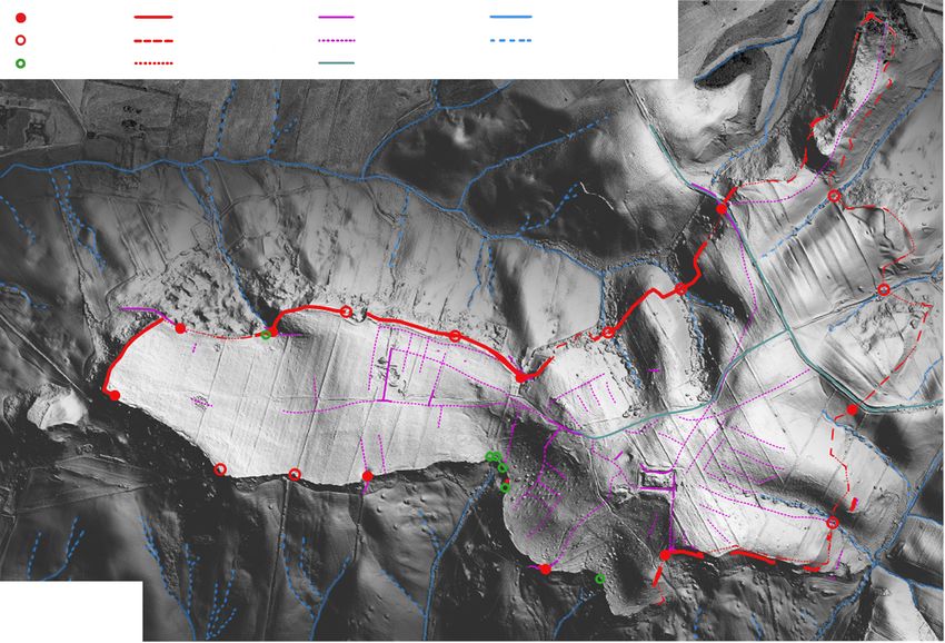
178Tarquinia: themes of urbanization on the Civita and the Monterozzi Plateaus
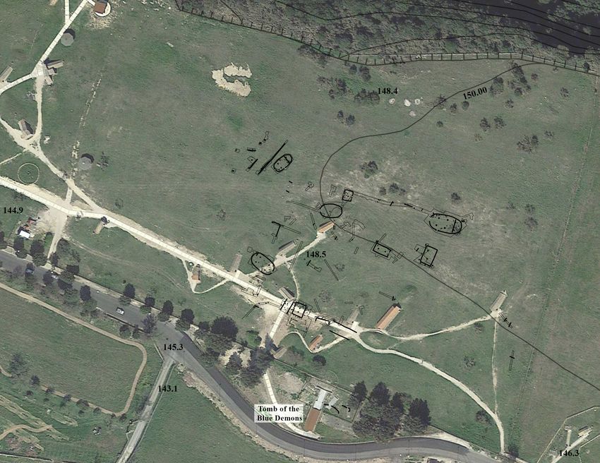
Figure 13.1. Positioning of the structures of the Calvario on the Google Earth orthophoto 2018 in combination with
Carta Tecnica Regione Lazio 2002: Top – structures found by R.E. Linington between 1975 and 1978; bottom –
structures found by Soprintendenza between 1985 and 1997 near the Tomb of the Blue Demons (M. Marzullo).
long before reaching the edge of the plateau, leaving belonged to the Calvario settlement (Fig. 13.1 bottom;
a large part of the territory seemingly empty. This was Cataldi et al. 2005, 431). This proves Linington’s initial
explained by the geomorphological conditions in this hunch, demonstrating the extension of the ‘village’ to
area, which are characterized by some depressions and the south, and allowing us to extend the occupied area
rocks, not suitable for buildings (Lerici 1959, 8–13; Lin- by a further quarter of a hectare. Overall, the settlement
ington 1982b, 118–19; Cavagnaro Vanoni 1997, 119–20). now measures about 29,000 sq. m, but this is certainly
These discoveries demonstrated the continuation of the likely to increase with further investigations.
built-up areas towards the west, south and east, with We can conclude that Calvario is located in a
a certain surface area of 200 × 100 m, even though the strategic area for the defence and control of the ter-
impression remains of a greater extension. Although ritory of the Civita Plateau (Mandolesi 1999, 198–9;
there has been no more opportunity to clarify the limits Bonghi Jovino 2014): not only does it look out over the
of the settlement through excavations, today, it is pos- entire coastal plain, but it is also in an intentionally
sible to add some further information. The excavation crucial position in the contemporary road network, as
along the old Provincial Road by the Soprintendenza shown in Figure 13.2 and explained below. The roads
between 1985–1997, after the discovery of the Tomb leading from the sea and from the surrounding minor
of the Blue Demons, brought to light some postholes settlements1 united at the gorge called Primi Archi,
and channels related to protohistoric huts, which likely thereby passing under Calvario settlement, and from
179Chapter 13
Settlement
Necropolis
Diffuse inhabited area
Hills
Supposed roads
i
Albucc
INHABITED AREA
er OF THE CIVITA
Riv
rta
S.
Ma
Sa
vin
o
CALVARIO
PRIMI
ARCHI
N
0 1 km
To the sea
Figure 13.2. Tarquinia and its territory around the middle of the eighth century bc (M. Marzullo).
there they headed to the Civita. It is not surprising, Monterozzi-Calvario area of Tarquinia, where a large
therefore, to find some vessels for transporting salt (see village of huts inhabited in the Villanovan period
below), the exploitation of which had been crucial for (ninth–eighth century bc) and later abandoned was
Tarquinia since its beginnings (Mandolesi 1999, 200–3; excavated. Above it was later built the great Etruscan
Bonghi Jovino 2002). necropolis with the celebrated painted tombs, as can
be seen from the work of the GIS topographic position-
The Calvario village on the Monterozzi Plateau ing, which allowed us to reconstruct the location of the
and its economic activities during the eighth structures in their spatial context (Fig. 13.1; see above).
century bc (CP) The re-examination of both the village plan and
the material found there, previously only partially
The study of domestic architecture and dwellings, their published, has allowed us to re-evaluate some aspects
internal organization and positioning in the settlement of the structure of the village, adding new information
has in recent decades received attention in numerous to its historical reconstruction (Piazzi 2016), especially
areas of archaeo-historical reconstruction, thanks to the with regard to its relationship with Civita and other
influence of disciplines like sociology, ethnology and settlements in the area. Firstly, the individual structures
environmental psychology. Domestic architecture can have been analysed and contextualized within a more
supply us with much data regarding material culture complete picture of Villanovan architecture, which
and, in particular, provide links to socio-cultural and over the years has been enriched by new data. We then
economic aspects of the societies that produced it.2 investigated the activities that took place within the
Here, we highlight some of these aspects by village, and in which structures, so as to obtain data on
focusing on the evidence that has emerged from the the use of space by the inhabitants, a factor, as pointed
180Tarquinia: themes of urbanization on the Civita and the Monterozzi Plateaus
out in the beginning, closely depending on the social, be associated with other structures or boundaries and
cultural and economic choices of the community. partitions of spaces created using fences (Fig. 13.3).
The hut village of Calvario was discovered in Linington initially subdivided the huts into four
the mid-1970s, thanks to the excavations made by the different types, based on their shape, to which he
Lerici Foundation and directed by R.E. Linington. The attributed different functions (Linington 1982): he
research was intended to clarify satrtigraphy relating to interpreted the square or rectangular structures as
the construction of the burial mounds over the tombs dwellings; oval structures as stables or warehouses;
in the necropolis (Linington et al. 1978, 4). The first while the narrower rectangular structures could have
excavation, in 1975, reaching bedrock in some places, been domestic but not dwelling places. The attribution
revealed some negative traces, post-holes and channels, of different functions to the structures was based on
relating to a series of structures defined as huts, and architectural considerations, later shown to be incor-
immediately identified as the remains of a protohistoric rect,3 and based on the quantity of material found
Villanovan village. After this, the excavation, which in each hut, especially in the case of the rectangular
continued in campaigns of a few months until 1978, structures. His interpretations were based on the idea
aimed at exploring this protohistoric village, traces that the structures referred to a single phase of habi-
of which were followed by enlarging the excavation tation, so the difference in shape had to be explained
trenches to reveal the complete plan of the structures. in terms of function rather than chronology. There
At the end of the investigation, the data allowed for the were, in fact, no clear signs of superposition between
reconstruction of various oval and rectangular huts, the different traces that were revealed, nor did the
nine of which were completely preserved (Huts 3, 3a, analysis of the material culture indicate a prolonged
7, 13, 14, 33, 42, 48, 55), another two could be partially life of the settlement.
reconstructed (38+39, 40+27), while at least twenty other From a sociohistorical point of view, the discovery
traces, including channels and post holes, can probably supported the theory that proposed, for the process of
45
46
50
49 44
51
55
54
41 19
47 13
53
48
5
23 20 34
4
21 22
39 24 17 14
35
33 36
38
2 1 11
0 20 m
7
37 29
8 N
26 32
12
3a
3b 3 40 27 30
31
Figure 13.3. Plan of the Villanovan village on the Monterozzi Plateau (C. Piazzi, after Linington 1982).
181Chapter 13
Etruscan urban formation, a model based on the exist- or aisle; there are also a series of other post holes placed
ence of distinctly separate and independent groups of in the central space, particularly near the northwest
villages, positioned in contiguous and strategic areas, corner, possibly evincing the presence of internal
which at a certain point of their history became united, furniture (shelves, beds, etc.). Structure 55, smaller in
giving rise to the nucleus of the future city. The case size than Structure 13, showed a similar separation, as
of Calvario was particularly emblematic, because the did Structure 7, although the latter was more disturbed
village stood on the hill facing the Civita Plateau, by subsequent interventions. The rectangular huts, on
where in the protohistoric period the first Tarquin- the other hand, seem less complex and do not have
ian settlement was developing contemporaneously: any internal subdivisions, apart from the presence
the village was located too close to be completely of the central posts supporting the roof (Fig. 13.4).
unrelated, but it was unquestionably ‘different’. The However, this apparent characteristic is not sufficient
abandonment of Calvario as a habitation area by the to assert that differences in the architectural features
end of the Villanovan phase could, moreover, be read of the structures can completely rule out that the same
as a consequence of a social and economic strengthen- domestic activities performed in the oval huts were also
ing of the Civita settlement. performed in the rectangular ones.5 Data and evidence
The progress of studies and the evidence that has in the Calvario village are too scarce to exclude other
emerged in other Etruscan cities demonstrate that this hypotheses. As mentioned before, one solution could
historical reading can no longer be considered correct. be to not consider each hut as an individual dwell-
The current theory is that different villages, even if they ing but as part of a compound, a group of structures
were effectively separate, must be read as a voluntary in which similar, different, and also complementary
and organic occupation of all the available space by activities might involve different areas and buildings.6
the first inhabitants through a collective choice and, The study of the excavation diaries has made it
thus, could already correspond to what we can define possible to recover also the information regarding the
as a ‘proto-urban structure’.4 For Tarquinia, this meant position of some of the material culture inside the struc-
not only the full occupation of the Civita Plateau, but tures that, with due caution, can help us understand
also the strategic Calvario settlement on the opposite the activities carried out near or inside them.7 In the
Monterozzi hill, which allowed for a more direct case of the oval Structure 13, two fragments of large
control of the coast (Fig. 13.2; Mandolesi 1999; Bonghi reddish-brown clay storage jars with cable decoration
Jovino 2001; 2005a). were found in the separate, apsidal area of the hut,
As expected, the revision of the documentation together with a spindle whorl and numerous other
allowed to clarify certain aspects of Tarquinia’s pro- non-diagnostic pottery fragments. Fragments of finer
tohistory. It should be noted that, already some time and better made tableware, such as a decorated cup
ago, some of Linington’s proposed interpretations were and bowl, come from the wider area. The positions of
revised. For example, the rigid functional separation of a glass paste bead, a cowrie shell and a bronze ring are
the structures that he had identified summarized above more difficult to identify although they were found in
were abandoned, since this was not supported by any an area near the long northern side of the structure (Fig.
other known examples. In particular, the comparison 13.5.1). The distribution of these materials, considering
with other sites has shown that it is still not possible to their ephemeral situation, is reflected in the analysis of
establish a direct relationship between the structures’ a very similar structure from the site of Sorgenti della
form and function, as there are cases of different types Nova (Dolfini 2002), where the quantity of remains
of plans coexisting and performing the same function, was decidedly more numerous. Noteworthy is the
or rather, they are complementary to one another, as similarity between the distribution of different types
seen in particular in the Protovillanovan village of of collected material: the storage jars, large containers
Sorgenti della Nova (Negroni Catacchio 1995), or also and tools for the fire were found mostly in the area
in Veii (Acconcia & Bartoloni 2014). Against Linington’s separated by a channel and thus ‘hidden’ from the
hypothesis, there is no evidence for example that the view; weaving and spinning tools were just outside
oval huts were not dwellings. The oval Structure 13, this boundary; whilst the finest or decorated dining
in fact, had some typical characteristics and a complex table vessels are present along the wall of the central
structuring of space: there are clear signs of a subdivi- area, in connection with traces that could be related
sion of the internal space by a channel that cuts the to shelves or benches. The analysis of the materials
apsidal end crosswise, and must have supported a from the oval Structure 7 at Calvario shows a rather
partition wall; inside, the structure shows further similar set of materials, with a cable-decorated storage
articulation of space due to the presence of pairs of jar, fragments of engraved wall decorations, a bowl
posts used to support the roof, creating a sort of nave with bulge decoration, and a decorated spindle whorl
182Tarquinia: themes of urbanization on the Civita and the Monterozzi Plateaus
N
7
13
14
33
55
0 10 m
Figure 13.4. Plans of some of the Villanovan huts: traces that have been found are in black, reconstructed traces are in
white (C. Piazzi, after Linington 1982).
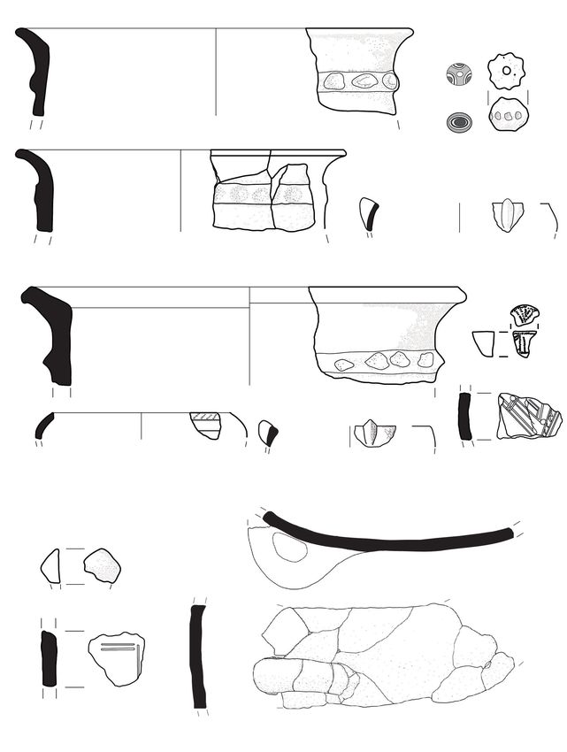
(Fig. 13.5.2). It was not possible to reconstruct the exact of the presence of the materials related to the same
original location of these pieces. activities connected to the domestic sphere. They
An interesting case is that of the rectangular seem to be located in the same spaces as elsewhere:
Structure 14. The repositioning of some wall fragments the central areas of the structures may have been used
from a large container has allowed us to reinterpret for convivial activities, demonstrated by the finest
the excavation plan of the structure, identifying as pottery, whilst material related to cooking and stor-
a possible pit for the conservation of food what had age, as well as tools used for textile production, were
been previously interpreted as a post hole for a roof relegated to the innermost spaces. Reasoning in terms
support, which however was strangely out of position of shared versus hidden from view or private spaces,
with respect to the room’s central axis. The only other this reading is quite suggestive, especially consider-
two significant fragments in the structure belong to a ing the possible social implications of the interactions
decorated vessel wall and a spindle whorl (Fig. 13.5.3). between different household members (e.g. at Sorgenti
It is not known whether the materials recovered, as della Nova; Negroni Catacchio & Domanico 2001).
a whole, are the direct reflection of the daily human Actions and their timing in dwellings could be linked
activity in the structures, interrupted by unidentifiable to what could be defined ‘public’ and ‘private’ types
causes, or if they are the result of a probable ‘selection’ of activities, which would have affected their visibility
and therefore of a residual legacy of less usable mate- and meaning to both the members of the household
rial left within the structures after their abandonment, and the outsiders. However, too little is known about
in positions that may not reflect those of their actual the proto-Etruscan socio-cultural organization, mak-
use. Furthermore, for Calvario we should also keep in ing it difficult to infer these aspects, especially since
mind the disturbance caused by the subsequent build- we are also conditioned by our modern ideas on what
ing of the necropolis. However, given the similarities ‘privacy’ is (Nevett 2011, 6, 24).
to structures found elsewhere, it may be significant to As far as the economic activities, which can
highlight the repetition, within the larger structures, only be partially recognized, the fragments of the
183You can also read