Technical Report Impacts on Marine and Freshwater Environments from Plantation Forestry - Envirolink
←
→
Page content transcription
If your browser does not render page correctly, please read the page content below
Technical Report
Impacts on Marine and Freshwater
Environments from Plantation Forestry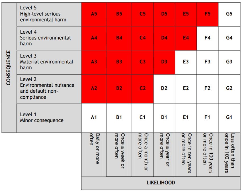
Prepared For
Prepared for: Marlborough District Council & Tasman District Council

Contract: 2118-MLDC158 (Envirolink large-advice grant)

Prepared By
Landpro Ltd
13 Pinot Noir Drive
PO Box 302
Cromwell
Tel +64 3 445 9905

Acknowledgements:
Envirolink project members, and the Marlborough District Council and Tasman District Council for their
valuable inputs and support for the project.

                                                                                                     ii
QUALITY INFORMATION
Reference: L:\20480 - University of Canterbury - Operational-level Landslide Risk
Management\Docs\Drafts\20210314_NES PF Forestry Report_Technical Report_FINAL.docx
Date: 16 March 2021
Prepared by: Christina Bright
Reviewed by: Mike Freeman
Client Review: Mark Bloomberg
Version Number: FINAL
Recommended Citation: Bright C. E. 2021. Impacts on Marine and Freshwater Environments from Plantation
Forestry. Prepared for Marlborough District Council and Tasman District Council. Envirolink Report 2118-
MLDC158.
Disclaimer:
We have prepared this report for our client based on their instructions. They may use it, as agreed between us. Landpro has no
duty, and does not make or give any express or implied representation or guarantee, whatsoever to any person other than our
client. If you are not our client then, unless this report has been provided to you as a local authority or central government agency
as part of a public process:
• you have no right to use or to rely on this report or any part of it, and
• you may not reproduce any of it.
We have done our best to ensure the information is fit for purpose at the date of preparation and meets the specific needs of our
client. Sometimes things change or new information comes to light. This can affect our recommendations and findings.
© Landpro Ltd 2021
iiiTABLE OF CONTENTS
TABLE OF CONTENTS .................................................................................................................................................................. IV
LIST OF FIGURES ........................................................................................................................................................................... IV
LIST OF TABLES ............................................................................................................................................................................. IV
EXECUTIVE SUMMARY ................................................................................................................................................................. 5
1. SCOPE AND STRUCTURE OF THIS REPORT ................................................................................................................ 7
2. STATUTORY FRAMEWORKS ............................................................................................................................................ 8
2.1 New Zealand Coastal Policy Statement (2010) ................................................................................................ 8
2.2 National Policy Statement for Freshwater Management (2020) ............................................................ 10
2.3 National Environmental Standard for Plantation Forestry (2017) .......................................................... 11
2.3.1 NESPF Implementation Challenges ................................................................................................................................................... 12
2.4 Proposed Marlborough Environment Plan ..................................................................................................... 14
2.5 Tasman Resource Management Plan (TRMP) ............................................................................................... 16
2.6 Implementation of Regulation by Councils ..................................................................................................... 17
2.7 Summary of Regulatory Frameworks .............................................................................................................. 18
3. ENVIRONMENTAL EFFECTS ON MARINE AND FRESHWATER .......................................................................... 18
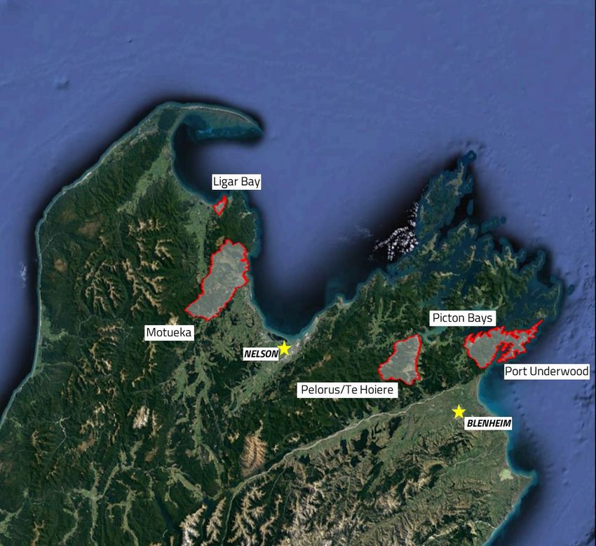
3.1 Case Studies ............................................................................................................................................................. 22
3.1.1 Picton Bays ........................................................................................................................................................................................................ 23
3.1.2 Te Whanganui/Port Underwood ......................................................................................................................................................... 25
3.1.3 Pelorus/Te Hoiere .......................................................................................................................................................................................... 27
3.1.4 Otuwhero Inlet ................................................................................................................................................................................................. 29
3.1.5 Motueka River – Shaggery Road ........................................................................................................................................................ 31
3.1.6 Golden Bay – Ligar Bay ............................................................................................................................................................................. 33
3.1.7 Summary ............................................................................................................................................................................................................. 35
4. A PROPOSED RISK ASSESSMENT TOOL ................................................................................................................... 37
5. CONCLUSION ...................................................................................................................................................................... 43
6. REFERENCES ..................................................................................................................................................................... 45
LIST OF FIGURES
Figure 1: Location of case study areas across Marlborough and Tasman Districts. .............................................. 22
Figure 2: Risk-matrix for environmental consequences (Source: EPA,2007) ........................................................... 39
LIST OF TABLES
Table 1: Summary of environmental effects of sediment and debris flows on freshwater and marine
environments. (Sources: Ryan (1991); Gillespie (2007); Bilotta and Brazier (2008); Geertsema et al. (2009);
Davies Colley et al. (2015); Visser and Harvey (2020); Urlich (2015, 2020). ............................................................ 21
Table 2: Comparison of adverse environmental effects based on consequence rating (Sources: noted in
heading for each column of the Table). ................................................................................................................................ 41
ivEXECUTIVE SUMMARY
Sedimentation in marine and freshwater environments from forested hillslopes in the Marlborough and
Tasman districts is a problem, with the potential to cause significant adverse environmental effects. In
particular, large infrequent events such as landslides and debris flows have great potential to cause long-
term significant adverse environmental effects. Both councils have invested substantially in the
understanding of the potential risks from sediment on marine and freshwater environments, by
understanding the predisposing factors that led to sediment discharges, landslides, and debris flows.
However, methods to rank the effects of these events by their likelihood is limited. There have been many
well-documented occurrences of large-scale movements of mud, rock, and woody debris originating from
commercial forestry catchments across Tasman and Marlborough and associated adverse effects.
There is a broad acceptance that forestry operators need to manage the risk of landslides and debris flows,
along with avoiding the effects of sedimentation, as now required under the National Environmental
Standard for Plantation Forestry (NESPF). However, the guidance on whether forestry activities will result in
such effects and require resource consent under the NESPF is very limited. Managing these risks with
confidence is limited by a critical lack of essential data and information to inform where and what mitigations
can be employed (sources, extent, frequency) and risk management of the effects (environmental, social, and
economic). This report focuses on the environmental component of these risks.
A high-level review of scientific literature was undertaken to identify the causes and consequences of
adverse effects from forestry in the Marlborough and Tasman districts. This review does not attempt to
repeat some of the more substantial reviews completed, rather it uses these to highlight the occurrence and
effects of forestry activities on marine and freshwater. These effects include the smothering of freshwater
estuarine and marine habitats by fine sediment, other direct and indirect effects on freshwater and marine
life, discolouration of the water column, deposition of woody debris, and destruction of property. This review
highlights the predisposing factors of the Marlborough and Tasman environment that result in inevitable
potential adverse effects from forestry activities, primarily harvesting. In part, this is due to the periodic
occurrence of high-intensity rainfall events, and the nature of the underlying lithology and soils.
This report discusses the current regulatory framework that applies for forestry activities in Marlborough and
Tasman areas and exemplifies through implementation of the NPSPF the ambiguity of permitted standards
by critiquing regulations within the NESPF related to sediment. This report attempts to provide insights on
additional regulatory tools for the MDC and TDC to assess as possible tools in implementing the NESPF, that
we think in collaboration with scientists, resource management practitioners, stakeholders, and foresters
can give decision-makers and foresters more certainty that effects from forestry are appropriately avoided
or mitigated in highly valued environments.
It is clear from a review of the relevant regional plans, the rules in these plans that are more stringent and
5prevail over the NESPF are relevant to the highly valued coastal and freshwater environments of
Marlborough and Tasman. It is therefore recommended that the MDC and TDC proceed jointly with
developing their own consistent tools for making assessments of activities considered to meet permitted
standards and if consent is required, to ensure that the identified possible effects will meet standards with
their Regional Plans and the Objectives and Policies of the NESPF.
61. SCOPE AND STRUCTURE OF THIS REPORT
This report contributes to an Envirolink large grant advice project, “Operational-level landslide hazard
identification and risk management to better manage the risk of erosion from harvested plantations on
slopes”. The scope of this report is therefore to:
1) Summarise the standards and or guidelines related to the relevant statutory documents, including
the National Environmental Standard for Plantation Forestry (2017), New Zealand Coastal Policy
Statement (2010) and National Policy Statement Freshwater (2020), as well as the relevant regional
planning documents.
2) Provide an overview of the available existing knowledge on what the impacts are for marine and
freshwater environments from sediment and organic debris (slash) originating from plantation
forestry sites in Tasman and Marlborough Districts.
3) Provide an overview of relevant risk assessment tools to support the development of methods for
assessing whether the characterised impacts from plantation forestry will meet standards, and or
can be practicably mitigated for freshwater and marine environments that will support regional
councils and decision-makers.
Section 2 outlines the relevant statutory documents as they relate to plantation forestry, with a brief
overview of the National Policy Statement for Freshwater (NPSFM) and the New Zealand Coastal Policy
Statement (NZCPS). A description of the relevant regulations from the National Environmental Standard for
Plantation Forestry (NESPF) is provided and discussed with respect to rules relevant to sediment and water
clarity. An overview of the regional plans for the Marlborough District Council (MDC) and Tasman District
Council (TDC) is provided for those rules with standards related to sediment and water clarity, and forest
activities.
Section 3 provides a brief overview of the potential impacts of plantation forestry on freshwater and marine
environments, with a focus on impacts originating from sediment transport, and organic debris (forestry
slash). The intent of this report is not to repeat previous publications that have already reviewed at length
and reported on the effects of forestry-related activities that can increase the frequency and impacts of soil
erosion (see: Urlich, 2015). Rather, case study areas are used to exemplify the process for assessing the
effects of plantation forestry which includes identifying the values within the case study areas and likely
effects based on historic events.
Section 4 of this report reviews the usefulness of a potential risk-based assessment approach to plantation
forestry and the possible impacts. This includes a brief review on utilising a risk matrix system that is tailored
for environmental consequences, and in future will seek input from council planning staff into the
classification of consequences (i.e., catastrophic to insignificant). The purpose of this part of the project is to
develop an efficient and effective method for assessing the severity of the characterised impacts
7(consequences) and whether the impacts will meet standards and or can be practicably mitigated for
freshwater and marine environments to support regional councils and decision-makers.
2. STATUTORY FRAMEWORKS
At a planning and regulatory level, the highest level of policy direction occurs with the Resource Management
Act (RMA), the New Zealand Coastal Policy Statement (2020) (NZCPS), and the National Policy Statement for
Freshwater Management (2020) (NPSFM). These high-level documents set the framework for the more
direct regulation that is contained in the National Environment Standard for Plantation Forestry (NESPF) and
relevant provisions of regional and district plans.
Until the NESPF came into force in May 2018, the rules governing forestry activities were provided solely in
district and regional council plans. These more local rules were designed to take into account local
environmental conditions and community priorities. Therefore, the new national regulations were designed
to provide a nationally consistent set of regulations. Rules in district or regional plans can be more stringent
than the NESPF rules. The NESPF regulates eight core forestry activities. The NESPF is underpinned by an
erosion susceptibility classification (ESC) framework (Bloomberg, 2011; Basher et al., 2015). The ESC classes
frequently determine if a forestry activity is a permitted activity (no resource consent required if conditions
complied with) or whether a resource consent is required. The NESPF also categorises forestry activities into
one of the following RMA resource consent categories: controlled, restricted discretionary, or discretionary.
The regulations apply to any forest larger than one hectare that has been planted specifically for commercial
purposes and harvest. In the following section the NESPF is described and a critique of regulations related to
sediment is provided.
Forestry in the Marlborough district is also currently regulated under the Marlborough Sounds Resource
Management Plan (MSRMP), the Wairau/Awatere Resource Management Plan (WARMP) and the Proposed
Marlborough Environment Plan (pMEP). Forestry in the Tasman district is managed under the Tasman
Resource Management Plan (TRMP).
2.1 New Zealand Coastal Policy Statement (2010)
The NZCPS applies to forestry activities in coastal environments with a suite of provisions that are relevant
to the development of regional and district plans as well as resource consent applications. Under the NZCPS,
three objectives are particularly relevant to forestry.
Objective 1
“To safeguard the integrity, form, functioning and resilience of the coastal environment and sustain its ecosystems,
including marine and intertidal areas, estuaries, dunes and land, by:
• maintaining or enhancing natural biological and physical processes in the coastal environment and
8recognising their dynamic, complex and interdependent nature;
• protecting representative or significant natural ecosystems and sites of biological importance and
maintaining the diversity of New Zealand’s indigenous coastal flora and fauna; and
• maintaining coastal water quality, and enhancing it where it has deteriorated from what would otherwise
be its natural condition, with significant adverse effects on ecology and habitat, because of discharges
associated with human activity.”
Objective 2
“To preserve the natural character of the coastal environment and protect natural features and landscape values
through:
• recognising the characteristics and qualities that contribute to natural character, natural features and
landscape values and their location and distribution;
• identifying those areas where various forms of subdivision, use, and development would be inappropriate
and protecting them from such activities; and
• encouraging restoration of the coastal environment.”
Objective 6
“To enable people and communities to provide for their social, economic, and cultural wellbeing and their health and
safety, through subdivision, use, and development, recognising that:
• the protection of the values of the coastal environment does not preclude use and development in
appropriate places and forms, and within appropriate limits;
• some uses and developments which depend upon the use of natural and physical resources in the coastal
environment are important to the social, economic and cultural wellbeing of people and communities;
• functionally some uses and developments can only be located on the coast or in the coastal marine area;
• the coastal environment contains renewable energy resources of significant value;
• the protection of habitats of living marine resources contributes to the social, economic and cultural
wellbeing of people and communities;
• the potential to protect, use, and develop natural and physical resources in the coastal marine area should
not be compromised by activities on land;
• the proportion of the coastal marine area under any formal protection is small and therefore management
under the Act is an important means by which the natural resources of the coastal marine area can be
protected; and
• historic heritage in the coastal environment is extensive but not fully known, and vulnerable to loss or
damage from inappropriate subdivision, use, and development.”
The NZCPS is relevant to forestry as it contains direction on activities within the coastal environment. There
are specific policies which require significant effects on biodiversity to be avoided, remedied, or mitigated
(Policy 11), and ecological implications related to the management of harmful aquatic organisms (Policy 12)
9avoided. Policy 13 sets out the preservation of the natural character of the coastal environment, and Policy
15 sets out the protection of these natural features and natural landscapes.
Sedimentation is specifically addressed under Policy 22, which requires assessment and monitoring of
sedimentation levels and impacts. It also requires controls on the effects of land-based activity (subdivision
and development, forestry, and others) that can increase the discharge of fine sediments and sediment
deposition in coastal habitats.
Policy 22: Sedimentation
1. “Assess and monitor sedimentation levels and impacts on the coastal environment.
2. Require that subdivision, use, or development will not result in a significant increase in sedimentation in
the coastal marine area, or other coastal water.
3. Control the impacts of vegetation removal on sedimentation including the impacts of harvesting plantation
forestry.
4. Reduce sediment loadings in runoff and in stormwater systems through controls on land use activities.”
Policy 23 sets out matters to have particular regard to when managing the discharge of contaminants.
2.2 National Policy Statement for Freshwater Management (2020)
The NPSFM 2020 sets out national-level objectives and policies that regional councils must ‘give effect to’ in
their planning documents, including by setting targets and limits for maintaining or enhancing water quality
and the ecological health of water bodies over time. The NPSFM sets a requirement to manage freshwater
in a way that ‘gives effect’ to Te Mana o te Wai through a new hierarchy of obligations that prioritises the
health and wellbeing of water bodies, then the essential needs of people (e.g., drinking water), followed by
other uses.
The NSPFM explains the concept of Te Mana o te Wai as “Te Mana o te Wai is a concept that refers to the
fundamental importance of water and recognises that protecting the health of freshwater protects the health and
well-being of the wider environment. It protects the mauri of the wai. Te Mana o te Wai is about restoring and
preserving the balance between the water, the wider environment, and the community.”
The NPSFM 2020 establishes a framework to improve degraded freshwater bodies and maintain or improve
all others that are implemented through regional and district plans that must give effect to the NPSFM and
the resource consent process where decision-makers must have regard to the NPSFM provisions. These
provisions include a complex suite of water quality “standards” defined in the National Objective Framework
(NOF). These include specific water quality “attributes” (measurable characteristics of water) that incorporate
national bottom lines (minimum standards). Of the relevant attributes aimed at providing for ecosystem
health, suspended fine sediment is included as an attribute requiring a limit on resource use, and deposited
10fine sediment is included as an attribute requiring action plans in regional plans.
Historically sediment management has been controlled through BMPs and limited suites of regional rules.
Now the NPSFM applies to forestry activities for managing the effects of sediment on freshwater. Regional
councils are required to achieve these targets within their regions primarily by amendment to regional plans,
the resource consent process, and non-regulatory methods. This will have important implications for the
forestry sector as sediment is the main contaminant of concern resulting from plantation forestry activities.
Two new attributes require management under the NPSFM NOF. These are suspended fine sediment and
deposited fine sediment. Each attribute is accompanied by a national bottom line for its concentration in
different water bodies, depending on the class of the specific waterbody. The classes for specific waterbodies
reflect the New Zealand River Environment Classification (REC) that spatially defines reaches of a water body
based on climate, source of flow, geology, landcover, position in the river network, and valley landform. Based
on the combination of the first three variables (climate, source of flow and geology) a numerical limit on
suspended fine sediment and deposited fine sediment is given in the units of visual clarity (m) and percentage
(%) of fine sediment cover, respectively.
In the cabinet paper on the Action for Healthy Waterways package, approximately 31% of New Zealand’s
monitored sites are reported to not meet the new bottom lines for sediment and will require improvements
(Cabinet Paper, 2020). Therefore, the inclusion of sediment in the NPSFM 2020 will likely result in increased
regulation of the forestry sector to manage sediment-related effects from plantation forestry activities.
2.3 National Environmental Standard for Plantation Forestry (2017)
The NESPF came into force on 1 May 2018. The NESPF generally prevails over RMA plan rules for managing
the environmental effects of plantation forestry, except where councils have more stringent plan rules (for
specific reasons such as managing sensitive receiving environments). Under the NESPF plantation forestry
activities do not require a resource consent where permitted activity conditions are complied with. Situations
where resource consent applications are required include where a forestry activity is in a high-risk area, as
described by the risk management tools incorporated in the NESPF (e.g., the Erosion Susceptibility
Classification tool, the Wilding Tree Risk Calculator, and the Fish Spawning Indicator). The Ministry for the
Environment has stated that the purpose of the NESPF is “to maintain or improve the environmental
outcomes associated with plantation forestry activities nationally and to increase the certainty and efficiency
of managing plantation forestry activities”. The NESPF regulations cover the following eight core plantation
forestry activities that have potential environmental effects.
• Afforestation.
• Pruning and thinning to waste.
• Earthworks.
• River crossings.
11• Forest quarrying.
• Harvesting.
• Mechanical land preparation.
• Replanting.
It is not yet clear whether the NESPF will be amended to reflect the sediment management provisions of the
NPSFM 2020, and the new numerical attributes related to suspended fine sediment and deposited sediment.
We think it is most likely that the two statutory instruments will be largely left to function in a complementary
manner with regional councils having specific regional responsibilities to assess the need for more stringent
rules to ensure the achievement of specific freshwater quality attributes in specific catchments.
The NESPF includes numerous regulations designed to manage sediment discharges from various plantation
forestry activities. As of January 2021, we understand that the relevant regional councils have modified
regional plans to be consistent with the NESPF provisions. Under the NESPF, Regulations 26, 56, 65, 74(6)
and 90 are permitted activity conditions relating to the effects of sediment discharges in receiving waters.
Under these regulations, sediment originating from forestry activities must be managed to ensure that, after
reasonable mixing, the activity does not give rise to any of the following effects in receiving waters:
• Any conspicuous change in colour or visual clarity.
• The rendering freshwater unsuitable for consumption by farm animals.
• Any significant adverse effect on aquatic life.
2.3.1 NESPF Implementation Challenges
Regulations 26, 56, 65, 74(6) and 90 in the NESPF are specified as standards for permitted activities, but as
the threshold is subject to “reasonable mixing” and “conspicuous change in colour or visual clarity” this needs
to be determined on a site-by-site basis. This is recognised in NESPF guidance released by the Ministry for
Primary Industries (MPI), although specific guidance for making site-by-site assessments is not provided.
The terms “reasonable mixing” and “conspicuous change” have been used in environmental law in New
Zealand since the Water and Soil Conservation Act 1967 (SWCA) (Simpson Grierson, 2010), that typically dealt
with point source discharges and not the non-point sources that are a key focus of current water quality
issues in New Zealand. There is some case law to assist interpretation of reasonable mixing and conspicuous
change. In Southland Regional Council v New Zealand Deer Farms the court considered that the "size of the
waterway, velocity of water, tributaries and the like" were factors to consider, and found that the numerical
reasonable mixing zone in the Plan could not be applied because of the need for a case-by-case approach
rather than a blanket zone for all activities and waterways. In Paokahu Trust v Gisborne District Council the court
stated that “reasonable mixing was held to be a question of fact”.
These above interpretations are relevant. However, those cases related to significant point source discharges
and we consider that it will be challenging to apply these principles to small waterways and catchments with
12multiple areas of largely diffuse discharges of sediment to freshwater bodies and/or coastal water. It is likely
that in these situations there will be interpretation disagreements about what constitutes reasonable mixing
and how conspicuous changes should be determined. When considering the implementation of the sediment
related regulations, the above criticism of the NESPF sediment regulations suggests that tools for
implementing the NESPF are needed. Considering the current lack of tools, Councils are likely to continue to
develop and use their own guidelines to help interpret NESPF permitted thresholds relating to the effects of
sediment discharges in receiving waters. Therefore, there may be a lack of national consistency if the
implementation of these permitted threshold matters differs between regional councils.
A comprehensive assessment of risk factors and implementation of all the relevant measures would provide
council certainty that all measures are in place for an activity to remain permitted under the regulations to
ensure ongoing compliance. There is guidance for councils on the assessment of management plans and the
content of these in terms of adequately complying with the permitted activity requirements. If the necessary
management practices are in place, the effects of sediment discharge on any receiving water would be
appropriately avoided or mitigated. A council may have evidence that the NESPF permitted activity
regulations do not or would not ensure achievement of NPSFM bottom lines or regional plan water quality
attributes. A regional council could then implement new regional plan rules that relate more specifically to
the best practice management that would achieve specific environmental outcomes/water quality attributes.
The NESPF enables the local authority to have more stringent rules in place to protect marine and freshwater
in the areas like the Marlborough Sounds and Tasman Region. If a council is concerned that the uncertainties
associated with “reasonable mixing” and “conspicuous change” are contributing to a deterioration in water
quality, then there would be grounds for the development of either specific guidance on the measures
necessary to ensure the avoidance of conspicuous change after reasonable mixing. If such guidance is not
effective, then a council can develop more stringent rules in a regional plan. This would normally take the
form of a set of regional plan rules that specify the physical measures to be taken and associated activity
class definitions (i.e., permitted activity, controlled activity, restricted discretionary activity, etc.) to ensure
that adverse effects would be avoided or adequately mitigated. This may result in more applications for
resource consents to allow a specific case by case assessment to determine what is needed to ensure
downstream water quality outcomes/water quality attributes are achieved.
The waterway characteristic details that the NPSFM sediment national bottom line utilises may be an
opportunity for those making assessments on resource consent requirements, compliance, and appropriate
avoidance or mitigation of possible environmental effects to fine-tune requirements to a specific subject site.
The NPSFM numerical attributes for suspended fine sediment and deposited sediment in freshwater
environments account for some level of natural variation between different river types by utilising the New
Zealand River Environment Classification (REC). The REC categorises a segment of a river within the overall
river network, based on its upstream catchment area, climate, topography, and geographic characteristics
(Snelder et al., 2010). Using this may give greater clarity on environmental outcomes.
13The below examination of the MDC and TDC regional plans exemplifies the situation for forestry under the
NESPF which prevails over many existing rules in the relevant regional plans.
2.4 Proposed Marlborough Environment Plan
The Marlborough District Council (MDC) is the planning/regulatory authority that exercises the functions of
both a regional and district council under the Resource Management Act (RMA) (1991) in the Marlborough
District.
The MDC’s resource management framework consists of the Marlborough Sounds Resource Management
Plan (2011) and the Wairau/Awatere Resource Management Plan (2011). In 2016, the MDC notified a new,
comprehensive Plan the proposed Marlborough Environment Plan (pMEP) to replace the multiple regulatory
documents, and the decisions version of the pMEP was released in early 2020, with aspects of the pMEP
subject to appeal.
In May 2018, MDC decided to retain the rules in the Marlborough Sounds Resource Management Plan
(MSRMP), the Wairau/Awatere Resource Management Plan (WARMP) and the Proposed Marlborough
Environment Plan (MEP), which are more stringent than the regulations in the NESPF. The retention of the
rules was set to be an interim position to maintain the status quo until the rules relating to plantation forestry
in the pMEP were determined.
The plantation forestry-related provisions of pMEP were developed to replace (where applicable) the
provisions of the MSRMP and WARMP. Whilst still operative, the more stringent rules in these plans would
apply and prevail over the NESPF. These rules related to forestry in the pMEP are therefore stricter than the
operative plans.
There are rules in the pMEP that were amended or removed, and advice notes were added to align the pMEP
with the NESPF. Several permitted activity standards that relate to forest harvesting are more stringent and
prevail over the NESPF, while those that are not more stringent were removed from the pMEP. Standards
related to the discharge of sediment to freshwater were removed (compared to the rules in the MSRMP and
WARMP), as these are covered under the NESPF. However, where these standards related to Significant
Wetlands or the coastal marine area, these were retained and considered more stringent under Regulation 6
of the NESPF, which allows plan rules to be more stringent than the NESPF regulations if a rule in a plan gives
effect to:
National instruments
1) A rule in a plan may be more stringent than these regulations if the rule gives effect to—
a) an objective developed to give effect to the National Policy Statement for Freshwater Management:
b) any of policies 11, 13, 15, and 22 of the New Zealand Coastal Policy Statement 2010.
14Matters of national importance
2) A rule in a plan may be more stringent than these regulations if the rule recognises and provides for the
protection of—
a) outstanding natural features and landscapes from inappropriate use and development; or
b) significant natural areas.
Unique and sensitive environments
3) A rule in a plan may be more stringent than these regulations if the rule manages any—
a) activities in any green, yellow, or orange zone containing separation point granite soils areas that are
identified in a regional policy statement, regional plan, or district plan:
b) activities in any geothermal area or any karst geology that are identified in a regional policy
statement, regional plan, or district plan:
c) activities conducted within 1 km upstream of the abstraction point of a drinking water supply for
more than 25 people where the water take is from a water body:
d) forestry quarrying activities conducted over a shallow water table (less than 30 m below ground
level) that is above an aquifer used for a human drinking water supply.
4) The areas and geology referred to in subclause (3)(b)—
a) may be identified in a policy statement or plan by any form of description; and
b) include only areas and geology where the location is identified in the policy statement or plan by a
map, a schedule, or a description of the area or geology.
Several of the land disturbance standards in the pMEP set out water quality standards that must be met for
an activity to be considered permitted. Some are more stringent than the provisions in the NESPF while
others duplicate regulations in the NESPF. To ensure alignment and no duplication (e.g., where there are no
provisions under the NESPF in which stormwater discharge standards in the pMEP could be more stringent
than the NESPF) the rules related to discharge of stormwater were altered so that regulations in the NESPF
prevail when the discharge of stormwater to water is managed by the NESPF.
Other activities that relate to the discharge of sediment or other debris were amended so that rules in the
pMEP that related to the removal of vegetation clearance, cultivation, excavation, were also allowed for the
NESPF where those activities could be related to plantation forestry.
Where the pMEP is more stringent the general permitted standard applies:
[Vegetation clearance/cultivation/excavation/non-indigenous vegetation clearance] must not cause any
conspicuous change in the colour or visual clarity of a flowing river after reasonable mixing, or the water in a
Significant Wetland, lake or the coastal marine area, measured as follows:
a) hue must not be changed by more than 10 points on the Munsell scale;
b) the natural clarity must not be conspicuously changed due to sediment or sediment-laden discharge
originating from the vegetation clearance site;
c) the change in reflectance must beThe wording of the relevant rules means that the above standard would only apply to forestry activities that
could affect significant wetlands and the coastal marine area and not a ‘flowing river’, and in matters
concerning freshwater, the NESPF regulations related to sediment prevails (Regulations 26, 56, 65, 74(6) and
90 are permitted activity conditions relating to the effects of sediment discharges in receiving waters). The
pMEP still included terms ‘reasonable mixing’ and ‘conspicuous change’, but numerical standards are given
which arguably provide greater clarity to those activities that fall under these pMEP rules.
2.5 Tasman Resource Management Plan (TRMP)
The Tasman District Council (TDC) has equivalent powers and functions to the MDC under the (RMA) in the
Tasman district.
At the time of the NESPF becoming operative the TDC made changes to the Tasman Resource
Management Plan (TRMP) and referenced where the rules were more stringent than the NESPF or where the
NESPF prevails over rules in the TRMP. Advice notes to this effect were inserted into the TRMP.
There are rules in the TRMP that are more stringent than the NESPF, and under Regulation 6(1) (a) or (b) of
the NESPF these more stringent rules prevail over the NESPF. These relate primarily to setbacks from the
coastal area, removal of indigenous vegetation, removal of vegetation, soil disturbance, and earthworks, cut
and fill volumes for culverts/fords/bridges in Land Disturbance Area 2, discharges to sinkholes, discharge of
sediment to a coastal waterbody, discharges of stormwater or drainage water to coastal water, or where a
rule relates especially to a location, for example, Separation Point Granite Soils or the Whanganui Inlet.
Rule 36.2.2.3 in the TRMP relates especially to the ‘Discharge of Sediment or Debris from Land Disturbance
Activities’. The NESPF prevails over Rule 36.2.2.3 (except Rule 36.2.2.3(a)(iii)) in relation to Plantation Forestry
as defined in the NESPF such that Regulations in the NESPF applies to any discharge where sediment or
debris may enter water.
Where the TRMP is more stringent under Regulation 6 of the NESPF, Rule 36.2.2.3 outlines the general
permitted standard for the discharge into water of sediment or debris, or water that may contain sediment
or debris, from any land disturbance activity. Under this Rule land disturbance activities are a permitted
activity that may be undertaken without a resource consent, if the activity complies with the following
conditions:
a) “The discharge is in such a manner that it does not cause any:
i. diverting or damming of any river or stream; or
ii. erosion of the bed of any river or stream; or
iii. discernible change to any habitat by deposition of sediment onto the bed of any water body or
coastal water body.
Advice Note: Clause (a)(iii) where it relates to the effects of a discharge containing sediment onto the bed of a ‘coastal
16water body’ prevails over the NES-PF because it is more stringent under Regulation 6(1)(b) NES-PF.
b) No soil or debris is placed directly into a water body or the coastal marine area.
c) The discharge must not cause the visual clarity of the receiving water to change by more than 40 per cent
as measured by a black disc at any point more than:
i. 50 metres downstream where the wetted width of the river is less than 5 metres; or
ii. 100 metres downstream where the wetted width of the river is between 5 metres and 20 metres;
or
iii. 200 metres downstream where the wetted width of the river is more than 20 metres; or
iv. 100 metres from the point of discharge in the coastal marine area; measured from the furthest
downstream point of the discharge.”
Like MDC’s pMEP, where rules prevail over the NESPF these are primarily due to a TRMP Rule giving effect
to the NZCPS and these being more stringent in relation to the coastal environment, or where a discharge is
to a sinkhole as the TRMP have more stringent rules, the permitted activity criteria above would apply. As
with the pMEP, the TRMP has numerical standards related to effects outside of the identified mixing zones
(matters (i) to (iv) of the above rule wording). This gives greater clarity on permitted thresholds for
determining compliance of activities and whether resource consent is required.
However, the types of provisions in the TRMP rule do assume that the TDC is checking the quality of water
at multiple locations during rainfall events and an appropriate monitoring programme would need to be in
place to record compliance.
2.6 Implementation of Regulation by Councils
Both councils, industry and central government agencies provide advice and encouragement on good
practices that reduce adverse effects. However, the focus of the NESPF and the council’s rules on permitted
activities as a key implementation mechanism to manage adverse effects of plantation forestry means that
there is a significant level of reliance on industry ‘self-policing’ the implementation of permitted activity
requirements. Important aspects of this include the industry commitment to meeting permitted activity
requirements, public visibility of practices, the ease of assessing the effects of non-compliance and the level
of councils’ investment in compliance monitoring and enforcement (CME) of permitted activity requirements.
Both councils have formal enforcement policies and the TDC has specific RMA charges for various forestry
inspections (provided for in the NESPF). However, independent reporting on CME of the regional sector
(Doole, 2020) has concluded: “…if significant non-compliance events are occurring from permitted activity
standards, then it may – in the long term- be desirable for that council to reconsider its non-regulatory approach to
that activity…” Two relevant key findings from that report were: “There is limited codification of permitted activity
monitoring across most of the sector. Cost recovery mechanisms appear influential in determining priorities.”
172.7 Summary of Regulatory Frameworks
The MDC and TDC have regional plans with rules related to activities that can discharge sediment and debris
to land and water. These rules have some numerical receiving water quality standards related to the
permitted threshold for determining compliance and the wording of the permitted standards provides some
additional certainty over the narrative standards in the NESPF. The pMEP and TRMP rule wording give
arguably greater clarity on permitted standards for plantation forestry activities in the coastal marine area,
regionally significant wetlands, or at specific locations identified in the TRMP or pMEP. In these
circumstances, the TRMP and pMEP are more stringent and therefore prevail under Regulation 6 of the
NESPF. In both regions, foresters working near the coast will likely require consent under the relevant
regional plan for discharges to the coastal environment, regionally significant wetland, or a specific location.
However, they also will require consent under the NESPF for discharges of sediment to freshwater and the
marine environment where conspicuous changes in the colour or clarity of water occur beyond the zone of
reasonable mixing. In both scenarios, monitoring and assessment of the state of the environment would be
required. This will result in forestry operators needing to comply with two sets of permitted standards for
discharges of sediment and organic debris.
3. ENVIRONMENTAL EFFECTS ON MARINE AND
FRESHWATER
Catchment management relies on the understanding that land and water are connected through several
dynamic processes. Forestry activities are widely acknowledged internationally to affect stream water
quantity and quality (e.g., Chang, 2006; Buttle, 2011) by altering the hydrological and biogeochemical
processes that occur within catchments. In New Zealand, forestry also is a recognised land use activity that
can result in changes to hydrological and biogeochemical processes (Neary et al., 1978; O’Loughlin et al., 1984;
Fahey, 1994; Fahey & Jackson, 1997; Adams & Fowler, 2006). In New Zealand in particular, given the high
value placed on natural resources, land disturbance effects from forestry activities have been studied (Fahey
& Jackson, 1997; Quinn et al., 1997; Glade, 2003; Clapcott et al., 2011). Johnston et al., (1981) raised concerns
of increased soil erosion resulting in deposition of fine-grained sediments and tree detritus in the
Marlborough Sounds. Increased erosion was signalled to potentially decrease the existing high-water quality
in the sounds and threaten marine life and farming, fishing, and the aesthetic qualities of the Sounds (Fransen
et al., 1998). Consequently, land disturbance is closely monitored, primarily via suspended sediment and
turbidity or water clarity measures, that are used as proxies for assessing impacts on freshwater and marine
environments, but also the impact on downstream users and continued stability of the land.
Mature trees are effective on steep land for limiting erosion in New Zealand (e.g., Ekanayake et al., 1997;
Marden, 2018). In terms of forestry, mature plantation forest tree roots reduce erosion on hillslopes by
increasing soil strength and slope stability. However, during and after clearance of plantation forests, root
18systems are damaged, and soil is significantly disturbed. Land vulnerability and how significant the loss of
soil is due to erosion depends on the characteristics of the environment and determines the ‘window of
vulnerability’ for large scale events occurring (Marden & Rowan, 2015). The conditions that predispose an
environment to erosion include ‘mechanical facets’, including soil type, surface land cover, and slope, and
those that are hydrological including water balance and soil permeability, and climate (Amishev et al., 2014).
Duration and frequency of intense rainfall events are key factors that trigger mass-movement and gully
erosion in steepland plantation forests (Satchell, 2018). The saturated conditions these large heavy rainfall
events cause increases the risk of slope failure (Bloomberg, 2011).
Forest clearance activities expose large areas of bare ground to the erosional effects of rain, surface runoff,
and wind, causing a high level of disturbance and increases in stream suspended sediment yield (Woodward
& Foster, 1997; Chang, 2006; Croke & Hairsine, 2006; Basher et al., 2011). This can result in compaction,
rapid runoff, and increased risk of landslides and other erosion processes (Croke & Hairsine, 2006).
Specifically, at and after the forest harvesting stage, sediment in stormwater run-off from roads and skid
sites entering waterways is a quick point-source of sediment in the disturbed landscape. Vehicles and
machinery crossing waterways without a properly formed culvert, ford or bridge can also create a lot of
sediment in waterways and damage the stream bed. More generally, landslips from post-harvested land can
generate large quantities of sediment and debris as a result of severe rainfall events and deliver this into
streams, even in forested settings (Marden & Rowan, 2015; O'Loughlin, 2005).
If harvest residues are left either in the waterway and/or floodplain or left on slopes susceptible to mass
movement, landslide-generated sediment when mixed with this woody debris can form a debris flow and if
confined to a channel, debris flows can be highly destructive (Scion, 2017; Visser, 2018). Shallow landslides
can transform into debris flows and deliver large quantities of sediment, boulders, and woody debris further
down the catchment (O'Loughlin, 2005). Debris flows erode ephemeral gullies and riparian margins because
of the large volume of sediment and debris carried (Phillips et al., 2017) and occur where slopes are steep and
susceptible to mass failure (Scion, 2017). Debris flows that entrain cut-over harvest residues are infrequent
but are high-risk events. Negative consequences downstream include debris dams, accumulation of material
along coastlines or in lakes channel erosion and scour, deposition of sediment and aggradation.
Sheet and rill erosion resulting from earthworks, harvesting and land preparation can result in loss of soil and
generation of sediment (Bloomberg, 2011). Surface erosion, although a relatively minor contributor of
sediment into water channels compared with gullying and landslides (Marden & Rowan, 2015; Marden et al.,
2007), can transport large loads of sediment down-slope and is a significant contributor of sediment to
streams and the coastal environment (Marden & Rowan, 1997; Marden et al., 2002; Marden et al. 2007). This
accelerated erosion is recognised in streams as increased suspended sediment yield and is used to
understand catchment-wide effects as a tracer for land disturbance (Croke & Hairsine, 2006).
In the Marlborough Sounds, sediment generation and risk of sedimentation are enhanced by forestry
activities occurring on a weathered lithology, with steep topography, in exposed areas subject to high-
19intensity rainfall (Laffan et al., 1985). In the Tasman Region steep highly erodible Separation Point Granite
geology predisposes forested landscapes to the risk of instability, including the influence of infrequent high
return period storms (Basher & Hicks, 2002; Clapp, 2009; Basher et al., 2011). Therefore, in these regions,
landslips, and sheet and rill erosion are common sediment mobilising mechanisms resulting in increased
sediment delivery to coastal and freshwater resources (Urlich, 2015). Furthermore, floods and debris flows
carry great potential for damage to infrastructure and environmental values. Past episodes of mass
movements from high-intensity rainfall events have shown the potential for damage is significant (e.g.,
Abbott, 2006; Dymond et al., 2006; Phillips et al., 2012). In the face of recent and increased media coverage
of these types of events (for example Ligar Bay 2011, Marlborough Sounds 2014, Tolaga Bay 2018, and the
Otuwhero River 2018) there appear to be public expectations that the forestry industry and regulatory
authorities will better manage forestry activities occurring in these landscapes.
Sediment generation and debris flows are the consequence of mass movement and/or surface erosion and
are connected to the fluvial system via hydrological flow paths. Hydrological flow paths direct eroded material
to receiving water bodies, where it is either held in temporary storage in the channel, mobilised and
transported downstream, or deposited at the river mouth into a final receiving body (lakes, estuaries, or the
coastal margin). Excess sediment in freshwater and marine environments reduces the growth of plants,
damages fish gills, and can smother riverbed and seabed ecosystems. The effects on receiving environments
of these forestry-related mass movement and sedimentation processes are well documented in New
Zealand, most recent reviews or studies include examples from North Canterbury (Baillie & Rolando, 2015),
Manawatu (Abbott, 2006, Basher 2013), Motueka (Basher et al., 2011), and the Marlborough Sounds, (Urlich,
2015; Urlich & Handley, 2020). The effects of debris flows are also well documented but appear more readily
in media reports than from literature sources, because of the often-damaging consequences of debris flows
on property and the built environment, and the natural environment.
This assessment has not included an analysis of the effectiveness of the NESPF, as that goes beyond the
scope of this report. Once the NESPF has been in effect for long enough to show conclusive effects, it would
be valuable to make this assessment of the NESPF’s effectiveness. Table 1 below summarises key
environmental effects from deposited sediment, fine sediment, and debris flows on the natural environment.
20Table 1: Summary of environmental effects of sediment and debris flows on freshwater and marine environments. (Sources: Ryan (1991); Gillespie (2007); Bilotta
and Brazier (2008); Geertsema et al. (2009); Davies Colley et al. (2015); Visser and Harvey (2020); Urlich (2015, 2020).
Deposited Fine Sediment Suspended Sediment Debris Flows
Smother benthic habitats and thereby change Increase turbidity and reduce light transmission in Debris flows deposit material at the coast typically
ecological composition by killing and displacing the water column and thereby affect in fans. Boulders and logs deposited in washouts
macrofauna. Seagrass reduced in extent and fine photosynthesis; change biogeochemical gradients and flooding. Forestry waste and slash washing up
sediment coating on the leaves. Effects of changing and cause negative effects to benthic microalgae; on beaches and log debris clogging river outflows
Marine sediment fluxes are frequently observed at the clog fish gills and the feeding parts of sediment- to coast. Sediment-laden plumes can extend over
Environment coast, as excessive loading of riverine sediment can dwelling filter-feeders, and cause chronic effects on large areas of coastline. Very fine-grained
Coastal/Estuary/ cause smothering of estuaries and the seafloor and macrofauna physiological condition and behaviour. sediments can be carried tens of kilometres, or
Lagoons can cause beach erosion or aggradation. Fine Excess fine sediment in the nearshore zones is a much further, offshore and transported along the
sediments on the relatively flat seabed surface can natural hazard and can silt up harbours and estuaries coast by wave action and tidal currents. Foreshore
be readily resuspended by tidal and wave-generated affecting shipping and navigation. and seafloor smothering with logs and forestry
currents to the extent that they interfere with the slash, mud and silt.
growth/survival of suspension-feeding shellfish.
Deposited sediment affects the substrate Deposits sediment into a stream or pollutes a Exacerbate flood hazard and potentially cause
composition of a waterway and therefore changes drinking water source with sediment and fine organic severe impacts for downstream infrastructure and
the coverage of fines and bed stability. Deposited debris. Clogging riverbed sediments and reducing communities. Debris flows have a very high
sediment provides a readily available in-stream habitat function. Reduce light transmission in the sediment concentration by weight and are more
source of sediment that can have flow-on effects water column and thereby affect light penetration, powerful and destructive than water alone and
Freshwater
downstream. Fine deposited sediment has a suspended sediment concentration, the visual may carry woody material and boulders. Damage
Rivers/Lakes/
complex relationship with periphyton and clarity, and sediment budget of a waterway. In lakes to river channels by filling and/or eroding the
Wetlands
macrophytes. Affects fish habitat and food supply. light transmission, oxygen demand, conveyance of stream channel for great distances. Capable of
Increased drift and decreased abundance of benthic sorbed contaminants is affected by sediment relocating and depositing large amounts of
invertebrates. In lakes, deposit sediment causes concentration, visual clarity and photosynthesis, material from the slopes to the valley bottoms.
benthic smothering, sediment resuspensions and depth limit for benthic plants, foraging efficiency, Dam streams and rivers impacting both water
alteration to sediment oxygen demand. food quality. quality and fish habitat.
21You can also read