Appendix A Notice of Preparation - Anaheim.net
←
→
Page content transcription
If your browser does not render page correctly, please read the page content below
BEACH BOULEVARD SPECIFIC PLAN DRAFT EIR
                                                         CITY OF ANAHEIM

                                                           Appendices

Appendix A    Notice of Preparation

August 2018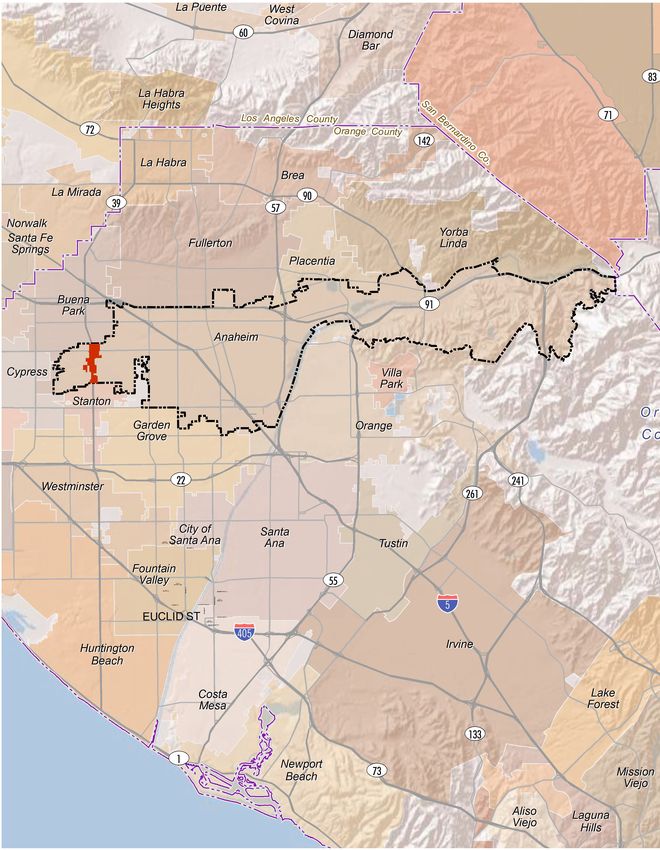
BEACH BOULEVARD SPECIFIC PLAN DRAFT EIR
CITY OF ANAHEIM

Appendices

This page intentionally left blank.

                                          PlaceWorks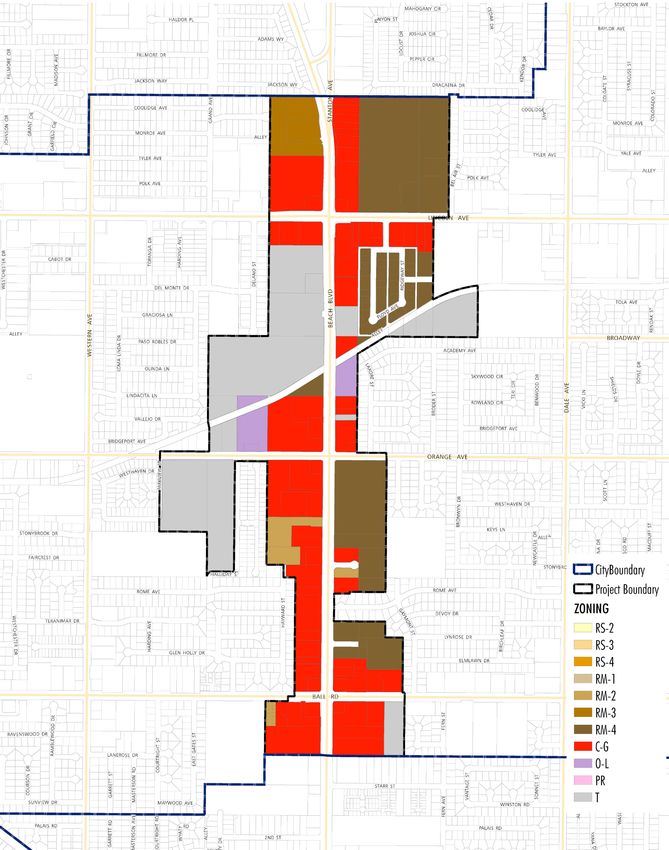
City of Anaheim
Planning and Building Department

                            Notice of Preparation

DATE:            April 13, 2017
TO:              Responsible Agencies, Property Owners, Residents and Interested
                 Parties
FROM:            City of Anaheim
SUBJECT:         Notice of Preparation of Draft Environmental Impact Report No.
                 350 for the Beach Boulevard Specific Plan

The City of Anaheim has received grant funding from the California Strategic Growth
Council to prepare the Beach Boulevard Specific Plan to guide future development
and public improvements along the approximately 1.5 miles of Beach Boulevard that
run through the City of Anaheim. In order to analyze the environmental effects
associated with the adoption of the plan, the City of Anaheim, as the Lead Agency,
will prepare Draft Environmental Impact Report No. 350 (DEIR No. 350). A detailed
project description, location information and initial study of the probable
environmental effects anticipated as a result of the adoption of the specific plan are
available on-line at www.anaheim.net/improvetheboulevard, at the City of Anaheim
Planning and Building Department (see address below), the Haskett Branch Library
(650 W Broadway, Anaheim, CA 92804) and Anaheim Central Library (500 W.
Broadway, Anaheim, CA 92805).

The purpose of this notice is to request input regarding the scope and content of the
environmental information that should be included in DEIR No. 350. This notice has
been sent to all responsible agencies, interested parties and property owners within a
300-foot radius of the project area. Due to the time limits mandated by State law,
please send your response at the earliest possible date, but no later than Friday,
May 12, 2017, at 5:00 p.m. Please send your response to Gustavo Gonzalez at the
City of Anaheim at the address below. If you are an agency responding to this
request, please provide the name for a contact person in your agency.

Scoping Meeting: The City of Anaheim will hold a scoping meeting at 6:30 p.m. on
Thursday, April 27, 2017 at the West Anaheim Youth Center, 320 S. Beach
Boulevard, Anaheim, California.

Project Title:             Beach Boulevard Specific Plan EIR No. 350

Project Applicant:         City of Anaheim

Send Responses to:         Gustavo N. Gonzalez, AICP, Senior Planner
                           City of Anaheim
                           Planning and Building Department
                           200 S. Anaheim Boulevard, MS 162
                           Anaheim, CA 92803

Questions:                 If you have any questions, please contact Mr. Gonzalez at
                           (714) 765-4671 or ggonzalez@anaheim.net.
                                   A-1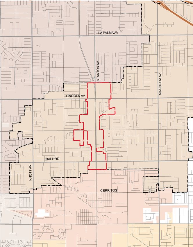
A-2
April 2017 | Initial Study

BEACH BOULEVARD SPECIFIC PLAN
                                         City of Anaheim

                                                     Prepared for:
                                                 City of Anaheim
                Contact: Gustavo N. Gonzalez, AICP, Senior Planner
                                    200 South Anaheim Boulevard
                                       Anaheim, California 92805
                                                     714.765.4671
                                         ggonzalez@anaheim.net
                          www.anaheim.net/improvetheboulevard

                                                     Prepared by:
                                                      PlaceWorks
                               Contact: William Halligan, Principal
                                   3 MacArthur Place, Suite 1100
                                     Santa Ana, California 92707
                                                    714.966.9220
                                           info@placeworks.com
                                            www.placeworks.com

          A-3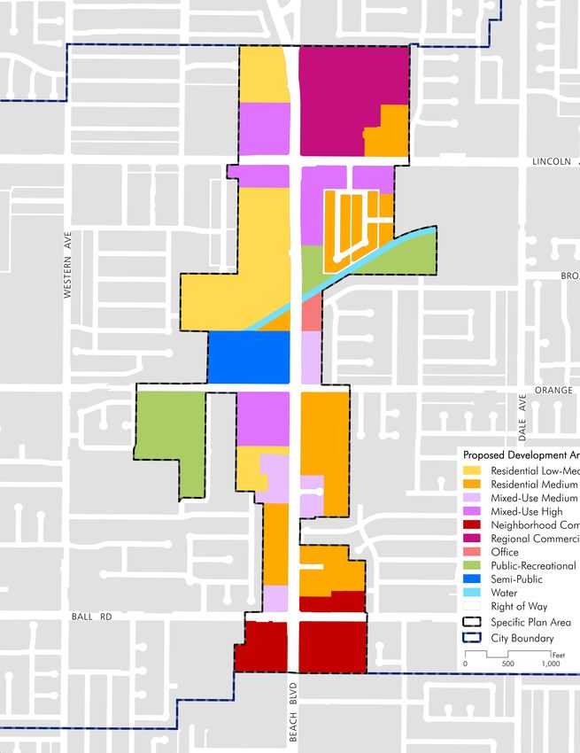
A-4
BEACH BOULEVARD SPECIFIC PLAN INITIAL STUDY
                                                                                                                       CITY OF ANAHEIM

                                                                                                                                       Table of Contents

Section                                                                                                                                                         Page

1.        INTRODUCTION ............................................................................................................. 1
          1.1  PROJECT LOCATION...................................................................................................................... 1
          1.2  ENVIRONMENTAL SETTING ..................................................................................................... 2
          1.3  PROJECT DESCRIPTION ............................................................................................................. 13
          1.4  PROJECT APPROVAL AND PERMITS ..................................................................................... 23
2.        ENVIRONMENTAL CHECKLIST .................................................................................. 25
          2.1  BACKGROUND................................................................................................................................ 25
          2.2  ENVIRONMENTAL FACTORS POTENTIALLY AFFECTED .......................................... 27
          2.3  DETERMINATION (TO BE COMPLETED BY THE LEAD AGENCY)........................ 27
          2.4  EVALUATION OF ENVIRONMENTAL IMPACTS............................................................... 28
3.        ENVIRONMENTAL ANALYSIS ..................................................................................... 39
          3.1  AESTHETICS .................................................................................................................................... 39
          3.2  AGRICULTURE AND FORESTRY RESOURCES .................................................................. 40
          3.3  AIR QUALITY ................................................................................................................................... 41
          3.4  BIOLOGICAL RESOURCES......................................................................................................... 43
          3.5  CULTURAL RESOURCES ............................................................................................................. 45
          3.6  GEOLOGY AND SOILS ................................................................................................................ 46
          3.7  GREENHOUSE GAS EMISSIONS ............................................................................................. 48
          3.8  HAZARDS AND HAZARDOUS MATERIALS ....................................................................... 49
          3.9  HYDROLOGY AND WATER QUALITY .................................................................................. 51
          3.10 LAND USE AND PLANNING..................................................................................................... 56
          3.11 MINERAL RESOURCES ................................................................................................................ 57
          3.12 NOISE.................................................................................................................................................. 58
          3.13 PALEONTOLOGICAL RESOURCES ........................................................................................ 59
          3.14 POPULATION AND HOUSING ................................................................................................. 59
          3.15 PUBLIC SERVICES .......................................................................................................................... 60
          3.16 RECREATION .................................................................................................................................. 62
          3.17 TRANSPORTATION/TRAFFIC .................................................................................................. 62
          3.18 TRIBAL CULTURAL RESOURCES............................................................................................. 64
          3.19 UTILITIES AND SERVICE SYSTEMS....................................................................................... 64
          3.20 MANDATORY FINDINGS OF SIGNIFICANCE ................................................................... 68
4.        REFERENCES .............................................................................................................. 69
5.        LIST OF PREPARERS .................................................................................................. 71
          CITY OF ANAHEIM ...................................................................................................................................... 71
          PLACEWORKS ................................................................................................................................................ 71

April 2017                                                                                                                                                       Page i
                                                                                A-5
BEACH BOULEVARD SPECIFIC PLAN INITIAL STUDY
CITY OF ANAHEIM
Table of Contents
List of Figures
Figure Page
Figure 1 Regional Location ................................................................................................................................. 3
Figure 2 Local Vicinity ......................................................................................................................................... 5
Figure 3 Aerial Photograph ................................................................................................................................. 7
Figure 4 Existing General Plan Land Use Designations ................................................................................ 9
Figure 5 Existing Zoning Designations .......................................................................................................... 11
Figure 6 Proposed Development Areas ......................................................................................................... 19
Figure 7 Proposed General Plan Land Use Designations ............................................................................ 21
List of Tables
Table Page
Table 1 Existing Uses in the Project Area ..................................................................................................... 14
Table 2 Beach Boulevard Specific Plan Buildout Statistical Summary ..................................................... 15
Table 3 Beach Boulevard Specific Plan Existing and Proposed Use Comparison ................................. 15
Table 4 Beach Boulevard Specific Plan Proposed Development Areas .................................................. 16
Page ii PlaceWorks
A-6BEACH BOULEVARD SPECIFIC PLAN INITIAL STUDY
CITY OF ANAHEIM
Abbreviations and Acronyms
AAQS ambient air quality standards
AB Assembly Bill
ACM asbestos-containing materials
ACOE Army Corps of Engineers
ADT average daily traffic
amsl above mean sea level
AQMP air quality management plan
AST aboveground storage tank
BAU business as usual
bgs below ground surface
BMP best management practices
CAA Clean Air Act
CAFE corporate average fuel economy
CalARP California Accidental Release Prevention Program
CalEMA California Emergency Management Agency
Cal/EPA California Environmental Protection Agency
CAL FIRE California Department of Forestry and Fire Protection
CALGreen California Green Building Standards Code
Cal/OSHA California Occupational Safety and Health Administration
CalRecycle California Department of Resources, Recycling, and Recovery
CAPCOA California Air Pollutant Control Officer’s Association
Caltrans California Department of Transportation
CARB California Air Resources Board
CBC California Building Code
CCAA California Clean Air Act
CCR California Code of Regulations
CDE California Department of Education
CDFW California Department of Fish and Wildlife
CEQA California Environmental Quality Act
CERCLA Comprehensive Environmental Response, Compensation and Liability Act
cfs cubic feet per second
CH4 methane
CHHSLs California Human Health Screening Levels
April 2017 Page iii
A-7BEACH BOULEVARD SPECIFIC PLAN INITIAL STUDY
CITY OF ANAHEIM
Abbreviations and Acronyms
CGS California Geologic Survey
CMP congestion management program
CNDDB California Natural Diversity Database
CNEL community noise equivalent level
CO carbon monoxide
CO2 carbon dioxide
CO2e carbon dioxide equivalent
Corps US Army Corps of Engineers
CPT Cone Penetrometer Test
CUP condition use permit
CUPA Certified Unified Program Agency
CWA Clean Water Act
dB decibel
dBA A-weighted decibel
DPM diesel particulate matter
DTSC Department of Toxic Substances Control
EIR environmental impact report
EMI Emissions Inventory Data
EPA United States Environmental Protection Agency
EPCRA Emergency Planning and Community Right-to-Know Act
FEMA Federal Emergency Management Agency
FHWA Federal Highway Administration
FTA Federal Transit Administration
GCP General Construction Permit
GHG greenhouse gases
GWP global warming potential
HAZNET Hazardous Waste Information System
HCM Highway Capacity Manual
HMS Hazardous Materials Section
HRA health risk assessment
HREC historical RECs
HQTA high quality transit area
HVAC heating, ventilating, and air conditioning system
Page iv PlaceWorks
A-8BEACH BOULEVARD SPECIFIC PLAN INITIAL STUDY
CITY OF ANAHEIM
Abbreviations and Acronyms
IPCC Intergovernmental Panel on Climate Change
Ldn day-night noise level
Leq equivalent continuous noise level
LBP lead-based paint
LCFS low-carbon fuel standard
LID low impact development
LOS level of service
LST localized significance thresholds
MW moment magnitude
MBTA Migratory Bird Treaty Act
MCL maximum contaminant level
MEP maximum extent practicable
mgd million gallons per day
MMT million metric tons
MPO metropolitan planning organization
MRZs Mineral Resource Zones
MT metric ton
MWD Metropolitan Water District of Southern California
N2O nitrous oxide
NAHC Native American Heritage Commission
NCCP/HCP Natural Community Conservation Plan/Habitat Conservation Plan
NOX nitrogen oxides
NPDES National Pollution Discharge Elimination System
O3 ozone
OCHCA Orange County Health Care Agency
OCWD Orange County Water District
OEHHA Office of Environmental Health Hazards Assessment
OES California Office of Emergency Services
PCBs polychlorinated biphenyls
PM particulate matter
POTW publicly owned treatment works
ppm parts per million
PPV peak particle velocity
April 2017 Page v
A-9BEACH BOULEVARD SPECIFIC PLAN INITIAL STUDY
CITY OF ANAHEIM
Abbreviations and Acronyms
PRDs Permit Registration Documents
RCRA Resource Conservation and Recovery Act
REC recognized environmental condition
RELS reference exposure levels
RMP risk management plan
RMS root mean square
RPS renewable portfolio standard
RSLs regional screening levels
RTP/SCS Regional Transportation Plan/Sustainable Communities Strategy
RWQCB Regional Water Quality Control Board
SARWQCB Santa Ana Regional Water Quality Control Board
SB Senate Bill
SCAG Southern California Association of Governments
SCAQMD South Coast Air Quality Management District
SCS Sustainable Communities Strategy
SF6 sulfur hexafluoride
SIP state implementation plan
SLM sound level meter
SMARA Surface Mining and Reclamation Act
SoCAB South Coast Air Basin
SOX sulfur oxides
SQG Small Quantity Generator
SQMP stormwater quality management plan
SR State Route
SRA source receptor area [or state responsibility area]
SUSMP standard urban stormwater mitigation plan
SWP State Water Project
SWPPP Storm Water Pollution Prevention Plan
TAC toxic air contaminants
TIA traffic impact analysis
TNM transportation noise model
tpd tons per day
TPH petroleum hydrocarbon
Page vi PlaceWorks
A-10BEACH BOULEVARD SPECIFIC PLAN INITIAL STUDY
CITY OF ANAHEIM
Abbreviations and Acronyms
TRI toxic release inventory
TTCP traditional tribal cultural places
USFWS United States Fish and Wildlife Service
USGS United States Geological Survey
UST underground storage tank
UWMP urban water management plan
V/C volume-to-capacity ratio
VdB velocity decibels
VHFHSZ very high fire hazard severity zone
VMT vehicle miles traveled
VOC volatile organic compound
WQMP water quality management plan
WSA water supply assessment
April 2017 Page vii
A-11BEACH BOULEVARD SPECIFIC PLAN INITIAL STUDY
CITY OF ANAHEIM
Abbreviations and Acronyms
This page intentionally left blank.
Page viii PlaceWorks
A-121. Introduction
The City of Anaheim (City), as the project applicant (Applicant), proposes to establish the Beach Boulevard
Specific Plan (BBSP) to guide future development of approximately 283 acres along a one and a half mile
stretch of Beach Boulevard-State Route 39 (SR-39) between the cities of Buena Park and Stanton, in the City
of Anaheim, Orange County.
This Initial Study presents information on the project and an evaluation of the probable environmental
effects anticipated by the project. Together with the Notice of Preparation (NOP) and the Environmental
Checklist Form, the Initial Study has been distributed to all responsible agencies as required by the California
Environmental Quality Act (CEQA). A notice has also been sent to all property owners within a 300-foot
radius of the BBSP area and other interested parties indicating that these documents are available for a 30-day
public review at Anaheim City Hall, Planning and Building Department, located at 200 S. Anaheim
Boulevard, Anaheim or on the project’s website (www.anaheim.net/improvetheboulevard), at the Haskett
Branch Library (2650 W Broadway, Anaheim, CA 92804), and at the Anaheim Central Library (500 W
Broadway, Anaheim, CA 92805).
1.1 PROJECT LOCATION
The Beach Boulevard Specific Plan Area (Project Area) encompasses approximately 283 acres along an
approximately 1.5-mile portion of Beach Boulevard-State Route 39 (SR-39) in the City of Anaheim, Orange
County. Beach Boulevard is an eight-lane divided highway that connects the cities of Huntington Beach,
Westminster, Garden Grove, Stanton, Anaheim, Buena Park, Fullerton, La Mirada, and La Habra.
Regional access to the Project Area is provided by State Route 91 (SR-91) and Interstate 5 (I-5) to the north
through the City of Buena Park. To the south, it connects to state Route 22 (SR-22) and Interstate 405 (I-405)
through the cities of Stanton and Westminster, the route terminates at State Route 1 (Pacific Coast Highway)
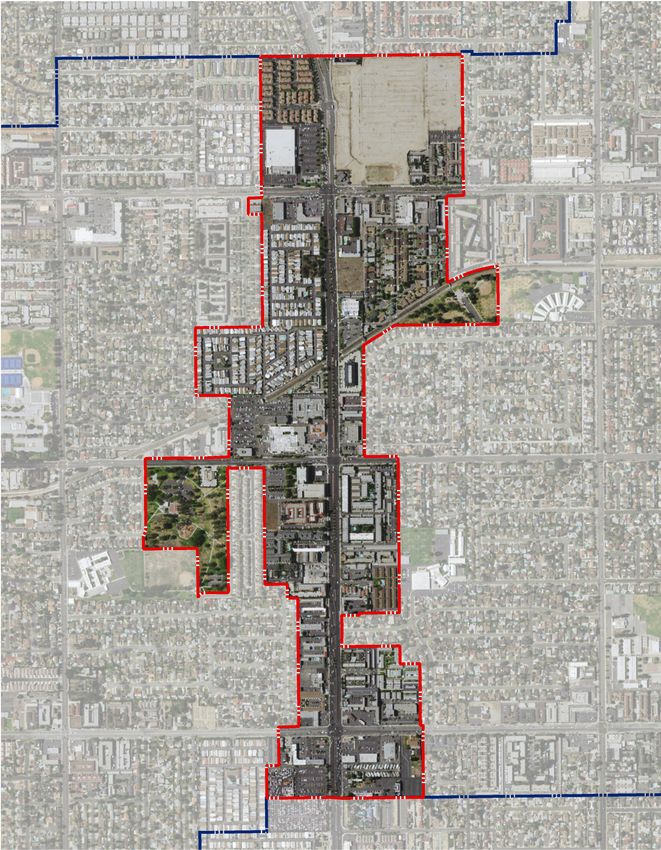
in Huntington Beach. Figure 1, Regional Location, depicts the regional location of the Project Area and
surrounding cities.
The segment of Beach Boulevard within the Project Area borders the City of Buena Park to the north and
the City of Stanton to the south. Major cross streets along the corridor within the City limits include Ball
Road, Orange Avenue, and Lincoln Avenue. An aerial photograph of the Project Area is shown on Figure 3,
Aerial Photograph.
April 2017 Page 1
A-13BEACH BOULEVARD SPECIFIC PLAN INITIAL STUDY
CITY OF ANAHEIM
1. Introduction
1.2 ENVIRONMENTAL SETTING
1.2.1 Existing Land Use
Originally serving as the only north-south route with direct access to the coastal cities of Orange County,
Beach Boulevard was once known as the “Road to Summer.” Significant development occurred along the
corridor in the City of Anaheim during the 1960’s and 1970’s to serve tourists visiting area beaches and
amusement parks. Over time, Interstate 5 (I-5), State Route (SR) 55, SR 73, and SR 133 provided alternative
access to Orange County’s beach communities. Today, Beach Boulevard no longer functions as the primary
tourist-oriented connection to the coastal cities in Orange County.
The existing uses within the Project Area include hospitality, commercial, residential, office, recreational, and
institutional facilities. Points of interest within the area include Twila Reid Park, Schweitzer Park, West
Anaheim Medical Center, and the West Anaheim Youth Center. Figure 2, Local Vicinity, shows local streets
around the Project Area. There are approximately 35 acres of vacant land. Existing land use details are
provided in Table 1.
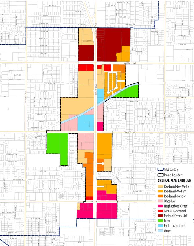
No specific plan has been adopted for the Project Area. Currently, development activities in the Project Area
are governed by the City’s adopted General Plan and Zoning Code. The existing General Plan designations
for the Project Area are shown on Figure 4, while the existing zoning designations are shown on Figure 5.
1.2.2 Surrounding Land Uses
Figure 2, Local Vicinity and Figure 3, Aerial Photograph, show the surrounding land uses to the Project Area.
The Project Area is surrounded by residential uses, the Knott’s Soak City and Knott’s Berry Farm theme
parks, and commercial uses along Beach Boulevard to the north; residential uses, the Twila Reid Elementary
School, Twila Reid Day Care Center, Danbrook Elementary School, Orange County Christian School,
Centralia Elementary School, and Western High School to the west; residential uses, Schweitzer Elementary
School, Baden Powell Head Start Preschool, Baden Powell Elementary School and Dale Junior High to the
east; and, residential uses, the Adventure City theme park, and commercial uses along Beach Boulevard to the
south. I-5 is approximately 1.6 miles to the northwest of the Project Area.
1.2.3 Existing Zoning and General Plan
The Project Area is zoned RS-2 (Single- Family Residential; 7,200 square feet minimum), RS-3 (Single-Family
Residential; 5,000 square feet minimum), RS-4 (Single-Family Residential), RM-1 (Multi-Family Residential;
one-acre minimum), RM-2 (Multi-Family Residential; 3,000 square feet minimum), RM-3 (Multi-Family
Residential; 2,400 square feet minimum), RM-4 (Multi-Family Residential; 1,200 square feet minimum), C-G
(General Commercial), O-L (Low Intensity Office), PR (Public Recreation), and T (Transitional) by the
General Plan Land Use Map. Figures 4, Existing General Plan Land Use Designations, and 5, Existing Zoning
Designations, show the respective land use designations for the Project Area.
Page 2 PlaceWorks
A-14B E A C H B O U L E VA R D S P E C I F I C P L A N I N I T I A L S T U D Y
CITY OF ANAHEIM
Figure 1 - Regional Location
Chino
Hills
Chino
Pacific Ocean
Specific Plan Boundary Anaheim City Boundary 0 3
Scale (Miles)
Base Map Source: ESRI, USGS, NOAA, 2017
PlaceWorks
A-15BEACH BOULEVARD SPECIFIC PLAN INITIAL STUDY
CITY OF ANAHEIM
1. Introduction
This page intentionally left blank.
Page 4 PlaceWorks
A-16B E A C H B O U L E VA R D S P E C I F I C P L A N I N I T I A L S T U D Y
CITY OF ANAHEIM
Figure 2 - Local Vicinity
5
City of Buena Park
City of Anaheim
AV
BEACH BLVD
City of Stanton
City of
Cypress City of Garden Grove
Note: Unincorporated county areas are shown in white.
0 0.5
Specific Plan Boundary City Boundary
Scale (Miles)
Base Map Source: ESRI, USGS, NOAA, 2017
PlaceWorks
A-17BEACH BOULEVARD SPECIFIC PLAN INITIAL STUDY
CITY OF ANAHEIM
1. Introduction
This page intentionally left blank.
Page 6 PlaceWorks
A-18B E A C H B O U L E VA R D S P E C I F I C P L A N I N I T I A L S T U D Y
CITY OF ANAHEIM
Figure 3 - Aerial Photograph
City of Buena Park
Lincoln Ave
Broadway
City of Anaheim City of Anaheim
Orange Ave
Beach Blvd
Stonybrook Dr
Western Ave
Dale Ave
Ball Rd
City of Stanton
0 1,000
Scale (Feet)
Base Map Source: ESRI, USGS, NOAA, 2017
PlaceWorks
A-19BEACH BOULEVARD SPECIFIC PLAN INITIAL STUDY
CITY OF ANAHEIM
1. Introduction
This page intentionally left blank.
Page 8 PlaceWorks
A-20B E A C H B O U L E VA R D S P E C I F I C P L A N I N I T I A L S T U D Y
CITY OF ANAHEIM
Figure 4 - Existing General Plan Land Use Designations
City of Buena Park
City of Anaheim
City of Anaheim
City Boundary
Project Boundary
General Plan Land Use
Residential-Low Medium
Residential-Medium
Residential-Corridor
Office-Low
Neighborhood Center
General Commercial
Regional Commercial
Parks
Public-Institutional
Water
City of Stanton
0 1,200
Scale (Feet)
Base Map Source: ESRI, USGS, NOAA, 2017
PlaceWorks
A-21BEACH BOULEVARD SPECIFIC PLAN INITIAL STUDY
CITY OF ANAHEIM
1. Introduction
This page intentionally left blank.
Page 10 PlaceWorks
A-22B E A C H B O U L E VA R D S P E C I F I C P L A N I N I T I A L S T U D Y
CITY OF ANAHEIM
Figure 5 - Existing Zoning Designations
City of Buena Park
City of Anaheim
City of Anaheim
City Boundary
Project Boundary
Zoning
RS-2
RS-3
RS-4
RM-1
RM-2
RM-3
RM-4
C-G
O-L
PR
T
City of Stanton
0 1,200
Scale (Feet)
Base Map Source: ESRI, USGS, NOAA, 2017
PlaceWorks
A-23BEACH BOULEVARD SPECIFIC PLAN INITIAL STUDY
CITY OF ANAHEIM
1. Introduction
This page intentionally left blank.
Page 12 PlaceWorks
A-24BEACH BOULEVARD SPECIFIC PLAN INITIAL STUDY
CITY OF ANAHEIM
1. Introduction
1.3 PROJECT DESCRIPTION
1.3.1 Description of the Project
Specific Plan
The Proposed Project consists of the adoption and implementation of a specific plan for the Project Area.
The Beach Boulevard Specific Plan (BBSP) would guide future development within 283 acres along the Beach
Boulevard corridor in the City of Anaheim. The proposed Specific Plan would establish a community-driven
vision supported by new development standards, permitted and prohibited uses, design guidelines, sustainable
practices, economic development incentives, and capital improvements that improve the quality of life for all
future users of the corridor.
Beach Boulevard Specific Plan
The City of Anaheim received funding for the BBSP through the California Strategic Growth Council’s
Sustainable Communities Planning Grant and Incentives Program. The implementation of the proposed
Specific Plan would strengthen the West Anaheim community and meet the Strategic Growth Council’s goals
to help local governments address the challenges of land use planning and transforming communities for
long-term prosperity. The Strategic Growth Council defines a sustainable community as one that promotes
equity, health, and safety, and strengthens the economy while protecting the environment.
The key components of the BBSP are:
Community-based Vision;
Goals and Objectives;
Development Areas;
Zoning and Development Standards;
Mobility and Streetscape Plan;
Infrastructure Plan;
Plan Administration;
Incentives and Implementation Program.
The BBSP is anticipated to promote revitalization of the Project Area by making market-driven land use
changes to encourage infill development of currently vacant or underutilized properties. An analysis of the
BBSP buildout potential is provided in Table 2 and net new development is provided in Table 3.
The BBSP would allow for the development of vacant parcels and the adaptive reuse or redevelopment of
existing uses. At buildout, implementation of the BBSP is expected to result in a maximum of 4,973 dwelling
units and 2,272,743 non-residential square feet as shown in Table 2. A comparison of existing and proposed
dwelling units and non-residential square footage is provided in Table 3.
April 2017 Page 13
A-25BEACH BOULEVARD SPECIFIC PLAN INITIAL STUDY
CITY OF ANAHEIM
1. Introduction
Table 1 Existing Uses in the Project Area
Total Floor Area
Land Use Acreage Units/Acre Units Population Ratio Non-Res. SF Employment5
Auto Dealership
1.1 -- -- 0.06 2,800 3
(Used)
Athletic Club (Batting) 0.9 -- -- -- -- 24,850 10
Auto Salvage Yard 4.6 -- -- -- -- -- 3
Car Wash 1.9 -- -- -- 0.07 5,783 6
Gas Station 1.6 -- -- -- 0.09 6,422 10
Retail 31.6 -- -- -- 0.26 351,249 162
Apartment 33.9 23.0 779 2,532 -- -- --
Condominium/
13.1 14.7 193 627 -- -- --
Townhome
Duplex 0.3 6.7 2 7 -- -- --
Four Plex 8.7 18.4 160 520 -- -- --
Mobile Home1 32.4 10.4 336 1,092 -- 1,268 0
Motel2 14.5 0.52 327,773 60
Single-Family
0.7 10.6 7 23 -- -- --
Residential
City Facility (Youth
2.9 -- -- -- 0.08 29,134 35
Center)
Community Center 1.3 -- -- -- 0.21 12,175 22
Flood Control Channel 6.9 -- -- -- -- -- --
Religious Use 3.5 -- -- -- 0.08 11,890 2
Hospital 12.8 -- -- -- 0.43 242,119 900
Nursing Home3 1.8 -- -- 138 1.02 79,958 46
Retirement Facility3 1.2 -- -- 200 -- 61,500 20
Medical Office 7.6 -- -- -- 0.34 113,602 348
Park4 22.8 -- -- -- 0.01 11,601 --
Right of Way 41.6 -- -- -- -- -- --
Vacant 35.2 -- -- -- -- -- --
TOTAL 282.8 -- 1,477 5,139 -- 1,282,124 1,627
Source: PlaceWorks, 2017.
1 There is a non-residential use (a psychic shop) in the mobile home park.
2 There are a total of 879 motel rooms within the Project Area.
3 There are 138 beds in the nursing home and 200 beds in the retirement facility.
4 Twila Reid Park includes an 8,181 SF fire station.
5 Employment figures were collected from the US Census Longitudinal Employer-Household Dynamics dataset except for the City Facility (Youth Center) employment
that was collected via phone call with facility staff.
Page 14 PlaceWorks
A-26BEACH BOULEVARD SPECIFIC PLAN INITIAL STUDY
CITY OF ANAHEIM
1. Introduction
Table 2 Beach Boulevard Specific Plan Buildout Statistical Summary
Floor Area
Proposed Development Areas Acreage Units/Acre Units Population Ratio Non-Res. SF Employment
Residential Low-Medium 44.8 18 806 2,621 -- -- --
Residential Medium 49.4 36 1,778 5,781 -- -- --
Mixed-Use Medium 12.5 36 450 1,463 0.35 190,575 476
Mixed-Use High 32.3 60 1,938 6,300 0.35 492,446 1,231
Neighborhood Commercial 22.6 -- -- -- 0.35 344,560 861
Regional Commercial 1 31.7 -- -- -- 0.35 483,298 1,208
Office 2.2 -- -- -- 0.50 47,916 168
Public-Recreational 27.9 -- -- -- 0.10 121,532 304
Semi-Public 2 13.6 -- -- -- 1.00 592,416 1,481
Flood Control Channels 4.2 -- -- -- -- -- --
Right of Way 41.6 -- -- -- -- -- --
Total 3 282.8 -- 4,973 16,166 4 -- 2,272,743 5,730 5
Source: PlaceWorks, 2017.
1 Regional Commercial buildout includes 35,000 SF of hotel/motel (70 rooms).
2 The West Anaheim Medical Center provides 219 hospital beds.
3 Hotels were included in the buildout assumptions for Mixed-Use Medium, Mixed-Use High, and Regional Commercial uses. Hotels were estimated at approximately
500 gross SF per room (including walls, elevators, stairways, corridors, storage, mechanical areas, etc.). This estimate anticipates the potential removal of 409
rooms in nine existing motels located in the Residential Medium Development Area, as motels will no longer be permitted in this development area.
4 Population estimates are based on a citywide 3.44 persons per household factor published in the City of Anaheim 2014-2021 Housing Element.
5 Employment estimates are City of Anaheim General Plan Employment Generation Rates of 400 SF per employee for Commercial uses, 285 SF per employee for
Office uses, and 400 SF per employee for Mixed-Use uses.
Table 3 Beach Boulevard Specific Plan Existing and Proposed Use Comparison
Proposed Non-Res
Existing Units Proposed Units Net New Existing Non-Res SF SF Net New
1,477 4,973 3,496 1,282,124 2,272,743 990,619
1.3.2 Proposed Development Areas
1.3.2.1 SPECIFIC PLAN DEVELOPMENT AREAS
The BBSP would establish nine development areas, as described in Table 4, and shown on Figure 6, Proposed
Development Areas. A General Plan Amendment will be processed as part of the Proposed Project to amend
the General Plan Land Use Plan to designate properties for land uses consistent with the proposed
development areas. The proposed General Plan land use designations are shown on Figure 7, Proposed General
Plan Land Use Designations.
April 2017 Page 15
A-27BEACH BOULEVARD SPECIFIC PLAN INITIAL STUDY
CITY OF ANAHEIM
1. Introduction
Table 4 Beach Boulevard Specific Plan Proposed Development Areas
Development Areas Description
Residential Low-Medium Residential Low-Medium Development Areas are intended to provide attractive, healthy, and safe
environments for attached single-family and multiple family units as either condominiums or apartments. They
allow for a range of housing types, including attached single-family townhouses, duplex or triplex buildings,
courtyard housing, and mobile home parks. Residential development is permitted at a density of up to 18
dwelling units per acre. The underlying Anaheim Municipal Code base zone is the “RM-2” Multiple Family
Residential Zone. If the standards in this Specific Plan are silent on a particular topic, the RM-2 Zone shall
apply..
Residential Medium Residential Medium Development Areas are intended to provide for quality, well-designed multifamily living
environments, as either condominiums or apartments, near transit and other services. These development
areas allow for a variety of housing types, including townhomes, courtyard housing, and stacked flats.
Residential development is permitted at a density of up to 36 dwelling units per acre. The underlying Anaheim
Municipal Code base zone is the “RM-3” Multiple Family Residential Zone. If the standards in this Specific
Plan are silent on a particular topic, the RM-3 Zone shall apply.
Mixed-Use Medium Mixed-Use Medium Development Areas are intended to allow flexibility for parcels that could transition from
strip commercial uses to residential or a mix of residential, commercial, and office development. They allow
residential in either a stand-alone or mixed-use configuration at a density of up to 36 dwelling units per acre.
Residential development in these areas emphasizes quality and offers a variety of amenities. A mix of
commercial uses would continue to allow for a range of community-serving retail, office, and service
commercial uses. The non-residential component of mixed-use development is permitted at a maximum floor
area ratio of 0.35. The underlying Anaheim Municipal Code base zone is the “MU” Mixed Use Overlay Zone.
If the standards in this Specific Plan are silent on a particular topic, the MU Overlay Zone shall apply.
Mixed-Use High Mixed-Use High Development Areas are intended to allow a mix of uses—including residential, commercial,
services, hospitality, and professional office uses—in a high-quality environment. The focus for new
development in these areas is on creating a pedestrian-friendly environment, including increased connectivity
and community gathering spaces. Uses and activities should be designed together to create a dynamic urban
environment. The preferred pattern of development is vertically mixed buildings with continuous commercial
street frontage on the first and, perhaps, second floors, supported by residential and/or office uses above.
Development may also mix uses in a horizontal or multi-use pattern. Stand-alone uses within a multi-use
project should be integrated with an overall project design and connected to other adjoining uses by plazas,
promenades, and landscaped corridors. They should also include common architectural themes and signage.
Typical residential uses could include stacked flats, live-work units, townhouses, and lofts. Residential
development in these areas emphasizes quality and offer a variety of amenities. The residential component of
mixed-use development is permitted at a density of up to 60 dwelling units per acre. The non-residential
component of mixed-use development is permitted at a maximum floor area ratio of 0.35. Stand-alone
residential and non-residential projects are permitted on parcels smaller than 2.5 acres and at a maximum of
60 dwelling units per acre or a floor ratio of 0.35, respectively. The underlying Anaheim Municipal Code base
zone is the “MU” Mixed Use Overlay Zone. If the standards in this Specific Plan are silent on a particular
topic, the MU Overlay Zone shall apply.
Neighborhood Commercial Neighborhood Commercial Development Areas are intended to provide for the daily shopping, dining, and
service commercial needs of the surrounding neighborhoods. Allowed uses include retail and services such
as grocery stores, specialty shops, small retail stores, hair salons, dry cleaners, restaurants, and coffee
houses. Projects should be designed to encourage pedestrian use by providing good connectivity within and
to the site, with buildings clustered and close to the street. Additionally, projects should be compatible in scale
and design with adjacent residential areas. Development is permitted at a maximum floor area ratio of 0.35.
The underlying Anaheim Municipal Code base zone for is the “C-NC” Neighborhood Center Commercial
Zone. If the standards in this Specific Plan are silent on a particular topic, the C-NC Zone shall apply.
Regional Commercial The Regional Commercial Development Area is intended to serve a larger market area than Neighborhood
Commercial areas. Given the regional nature of the Beach Boulevard corridor and the tourism market to the
north in Buena Park, this development area allows for large-scale commercial uses, specialty stores and
restaurants, a theater, home goods stores, entertainment, commercial recreation, and hospitality uses that
serve a broad area. Projects should be designed to encourage pedestrian use by providing good connectivity
within and to the site, with buildings clustered and close to the street. Development is permitted at a
maximum floor area ratio of 0.35. The underlying Anaheim Municipal Code base zone is the “C-R” Regional
Page 16 PlaceWorks
A-28BEACH BOULEVARD SPECIFIC PLAN INITIAL STUDY
CITY OF ANAHEIM
1. Introduction
Table 4 Beach Boulevard Specific Plan Proposed Development Areas
Development Areas Description
Commercial. If the standards in this Specific Plan are silent on a particular topic, the C-R Zone shall apply.
Office The Office Development Area is intended to allow a variety of small-scale office uses, including legal
services, insurance services, real estate services, and medical or dental offices, and other support services.
Development is permitted at a maximum floor area ratio of 0.50. The underlying Anaheim Municipal Code
base zone is the “O-L” Office Low Zone. If the standards in this Specific Plan are silent on a particular topic,
the O-L Zone shall apply.
Public-Recreational Public Recreational Development Areas are intended to provide active and passive public park and open
space, areas including Twila Reid and Schweitzer Parks, as well as public facilities such as the West
Anaheim Youth Center. They also include ancillary public buildings and facilities, such as a fire station and
small recreation buildings. The underlying Anaheim Municipal Code base zone is the “PR” Public
Recreational Zone. If the standards in this Specific Plan are silent on a particular topic, the PR Zone shall
apply.
Semi-Public The Semi-Public Development Area is intended to accommodate hospitals, nursing homes, assisted living
facilities, and other medical-related uses in a clustered activity center to support West Anaheim and the
surrounding area. The underlying Anaheim Municipal Code base zone is the “SP” Semi-Public Zone. If the
standards in this Specific Plan are silent on a particular topic, the SP Zone shall apply.
Source: City of Anaheim; PlaceWorks (2017)
In addition to revitalizing the corridor with new development, use types, and adaptive reuse, the proposed
Specific Plan would also facilitate and encourage use of multiple modes of transportation by improving
pedestrian amenities, and access to Orange County Transit Authority Route 29 (La Habra to Huntington
Beach), Route 42 (Seal Beach to Orange), and Route 46 (Los Alamitos to Orange). The Southern California
Association of Governments (SCAG) has designated Beach Boulevard as a High Quality Transit Area
(HQTA). A HQTA is generally a walkable transit village or corridor that is within a half mile of a well-
serviced transit stop or a transit corridor with 15-minute or less service frequency during peak commute
hours. The 2016 SCAG Regional Transportation Plan/Strategic Communities Strategy projects that HQTA’s
should accommodate over 40 percent of the region’s future household growth and over 50 percent of the
future employment growth (SCAG 2016).
Relinquishment of Beach Boulevard
Within the City of Anaheim, Beach Boulevard (SR-39) is a California state highway that travels through
Orange and Los Angeles counties. In order to have greater control over all infrastructure which includes
roadway, landscaping, medians, pedestrian access ramps and driveway entrances, the City may seek
relinquishment of Beach Boulevard from the California Department of Transportation (Caltrans) to the City
of Anaheim. Relinquishment is the act and the process of legally transferring property rights, title, liability,
and maintenance responsibilities of a portion or entirety of a state highway to another entity. The removal of
a highway or associated facilities, either in whole or in part, from the State Highway System (SHS) requires
approval by the California Transportation Commission (CTC).
April 2017 Page 17
A-29BEACH BOULEVARD SPECIFIC PLAN INITIAL STUDY
CITY OF ANAHEIM
1. Introduction
Other Public Realm Improvements
The Specific Plan also proposes other improvements within the public realm including urban amenities and
improvements to public rights-of-way, including key intersections, streets, alleys and drives, parks, plazas, and
gateways. The Specific Plan identifies public street design elements, landscaping, intersection enhancements,
entry treatments, public open space, right-of-way detail, and other unique public realm features within the
proposed Development Areas. Other improvements include the undergrounding of utilities and removal of
utility poles.
Proposed City Approvals
Approval of the BBSP project includes certification of Environmental Impact Report No. 2017-00350,
including the adoption of Findings of Fact and a Statement of Overriding Considerations, Mitigation
Monitoring Program 342 and a Water Supply Assessment; approval of amendments to the General Plan and
Zoning Code (zoning text and zoning map); as well as, adoption of a new specific plan, the Beach Boulevard
Specific Plan. Together, the proposed approvals and their implementation constitute the “Project” for
purposes of the California Environmental Quality Act (CEQA). Below is a description of the proposed
approvals.
General Plan Amendment No. 2015-00500: Amend the General Plan Land Use, Circulation, Green,
Economic Development, and Community Design Elements to be consistent with the Beach Boulevard
Specific Plan.
Specific Plan No. 2017-00001: Adopt the Beach Boulevard Specific Plan (SP2017-01).
Zoning Code Amendment No. 2017-00137: Adopt Chapter 18.122 (Beach Boulevard Specific Plan
(SP2017-01) Zoning and Development Standards) and amend other portions of the Anaheim Municipal
Coe to be consistent with the addition of the new Chapter 18.122.
Reclassification No. 2017-00304: Adopt an ordinance to apply the zoning and development standards
of the proposed new Chapter 18.122 to those properties within the Beach Boulevard Specific Plan
project area that are currently classified under the “RM-2” Multiple-Family Residential Zone, “RM-3”
Multiple-Family Residential Zone, “RM-4” Multiple-Family Residential Zone, “C-G” General
Commercial Zone, “O-L” Low Intensity Office Zone and “T” Transition Zone.
Page 18 PlaceWorks
A-30B E A C H B O U L E VA R D S P E C I F I C P L A N I N I T I A L S T U D Y
CITY OF ANAHEIM
Figure 6 - Proposed Development Areas
City of Buena Park
City of Anaheim
City of Anaheim
Proposed Development Areas
Right-of-Way
Specific Plan Area
City Boundary
Residential Low-Medium
Residential Medium
Mixed-Use Medium
Mixed-Use High
Neighborhood Commercial
Regional Commercial
Office
Public-Recreational
Semi-Public
Water
City of Stanton
0 1,000
Scale (Feet)
Base Map Source: ESRI, USGS, NOAA, 2017
PlaceWorks
A-31BEACH BOULEVARD SPECIFIC PLAN INITIAL STUDY
CITY OF ANAHEIM
1. Introduction
This page intentionally left blank.
Page 20 PlaceWorks
A-32B E A C H B O U L E VA R D S P E C I F I C P L A N I N I T I A L S T U D Y
CITY OF ANAHEIM
Figure 7 - Proposed General Land Use Designations
City of Buena Park
LINCOLN AVE
WESTERN AVE
LINCOLN AVE
BROADWAY
City of Anaheim LINCOLN AVE
WESTERN AVE
BROADWAY
ORANGE AVE
WESTERN AVE
DALE AVE
BROADWAY
City of Anaheim
Proposed General Plan Land Uses
Residential Low-Medium Density
ORANGE AVE
DALE AVE
Residential Medium Density
Mixed - Use
Neighborhood Center
Regional Commercial ORANGE AVE
DALE AVE
Office - Low
Parks
Institutional
Proposed General Plan Land Uses
Proposed
WaterGeneral
Uses Plan Land Uses
Residential Low-Medium Density
Right of Way
Right-of-Way
BALL RD Residential Medium Density
Specific
Specific
MixedPlanPlan
- Use Area
Area
Proposed
City
City General
Boundary
Boundary
Neighborhood Plan Land Uses
Center
Residential
Residential Low-Medium
RegionalLow-Medium
Commercial
Feet Density
Density
0 Residential
Residential
Office
500
- LowMedium
Medium
1,000 Density
Density
Mixed
Mixed-Use
Parks - UseMedium
BEACH BLVD
Neighborhood
Neighborhood
InstitutionalCenterCenter
Regional
Regional Commercial
Water Commercial
Uses
Office
Office
Right- -Low
Low
of Way
BALL RD Parks
Parks
Specific Plan Area
Institutional
Institutional
City Boundary
WaterUses
Water Uses
Right of Way Feet
BALL RD 0 500 1,000
Specific Plan Area
PROPOSED GP LAND USE PLAN City Boundary
BEACH BLVD
Feet
City of Stanton 0 500 1,000
Date: 2/22/2017
Feet
0 150 300 600 900 1,200
BEACH BLVD
Source: PlaceWorks, 2017
0 1,000
Scale (Feet)
Base Map Source: ESRI, USGS, NOAA, 2017 PROPOSED GP LAND USE PLAN
PlaceWorks
A-33 Date: 2/22/2017
Feet
PROPOSED GP LAND USE PLAN
0 150 300 600 900 1,200
Source: PlaceWorks, 2017BEACH BOULEVARD SPECIFIC PLAN INITIAL STUDY
CITY OF ANAHEIM
1. Introduction
This page intentionally left blank.
Page 22 PlaceWorks
A-34BEACH BOULEVARD SPECIFIC PLAN INITIAL STUDY
CITY OF ANAHEIM
1. Introduction
1.3.3 Project Phasing
The Specific Plan project will be implemented in multiple phases over the next 20 years or more.
Development of the project area and time frames would be controlled by City decisions on parcels under
their ownership and improvements to public infrastructure, as well as landowner decisions on the
development of privately owned properties. Implementation of the specific plan will require collaborative
efforts among local businesses, institutions, residents, the City, developers, the California Department of
Transportation (Caltrans), Southern California Edison (SCE) and any other utility providers to the area.
The initial implementation phase will include Proposed Project adoption, the necessary amendments to City
documents, and the proposed relinquishment of Beach Boulevard in the City from the California
Department of Transportation to the City of Anaheim. Building development in the near-term is anticipated
to include development of a vacant parcel owned by the City at the corner of Beach Boulevard and Lincoln
Avenue (known as the Westgate Site). Additionally, a City owned parcel adjacent to the West Anaheim Youth
Center, and if acquired by the City, parcels to the north up to the corner of Lincoln Avenue and Beach
Boulevard, could be a possible location for near-term investment and development. The remainder of
development is expected to occur in market-driven phased over several decades.
The BBSP can be implemented using a variety of funding sources, including but not limited to, the City
General Fund. District-based and contractual assessment tools are options that would allow areas in this plan
to benefit from the funding they collect. Developer contributions, impact fees, and standard agreements can
all be used by the City to initiate public right-of-way improvements. Regional, state, and federal grants as well
as City funds such as the capital improvement program are also potential funding sources. In addition, the
City has recently established a Beach Boulevard Economic Development Initiative that will include
development fee deferrals or waivers for preferred uses, commercial and residential rehabilitation loans, and
other elements.
Flexibility in project implementation is important for responsiveness to changing economic conditions and
trends, which may require that the City reprioritize the specific plan’s implementation steps. For purposes of
evaluating environmental impacts, buildout of this proposed Specific Plan is anticipated to occur by 2035.
1.4 PROJECT APPROVAL AND PERMITS
The City of Anaheim is the lead agency under CEQA and has the principal approval authority over the BBSP.
A responsible agency is a public agency other than the lead agency that has responsibility for carrying out or
approving a project (CEQA Guidelines § 15381 and PRC § 21069). The following discretionary actions will
be required to implement the project:
April 2017 Page 23
A-35BEACH BOULEVARD SPECIFIC PLAN INITIAL STUDY
CITY OF ANAHEIM
1. Introduction
Lead Agency Action
Anaheim City Council Certify Environmental Impact Report No. 2017-00350 and adopt Findings, a
Statement of Overriding Considerations, and Mitigation Monitoring Program No.
342 and Water Supply Assessment
Adopt General Plan Amendment No.2015-00500.
Adopt the Beach Boulevard Specific Plan (SP2017-01)
Reclassify properties within the project area to the new Beach Boulevard
Specific Plan Zone (SP2017-01)
Adopt proposed Zoning Code Chapter 18.220 (Beach Boulevard Specific Plan
(SP2017-01)
Implementation of the Beach Boulevard Specific Plan (e.g., any additional
discretionary review of uses allowed by right by the BBSP, conditional use
permits and variances that are consistent with the BBSP, subdivision maps,
grading permits, street improvement plans, financial mechanisms including but
not limited to assessment districts, etc.) except as limited by Section 15162 of
the CEQA Guidelines.
Responsible Agencies Action
South Coast Air Quality Management District Issue necessary air quality permits to implement the project.
Regional Water Quality Control Board Issue National Pollutant Discharge Elimination System Permit to implement the
project.
Orange County Sanitation District (OCSD) Approve necessary sewer upgrades to OCSD facilities.
California Department of Transportation (Caltrans) Approve relinquishment of Beach Boulevard (SR-39).
Orange County Transportation Authority (OCTA) Measure M funding for roadway improvements; review of bus stops and turnouts;
Master Plan of Arterial Highways (MPAH) Amendment
Orange County Flood Control District (OC Flood) Provide necessary infrastructure improvements.
Orange County Water District Provide necessary infrastructure improvements.
Southern California Edison (SCE) and other
Approve undergrounding of utilities
applicable utility providers
Page 24 PlaceWorks
A-362. Environmental Checklist
2.1 BACKGROUND
1. Project Title: Beach Boulevard Specific Plan
2. Lead Agency Name and Address:
City of Anaheim
Anaheim Planning and Building Department
200 South Anaheim Boulevard, Suite 162
Anaheim, California 92805
3. Contact Person:
Gustavo N. Gonzalez, AICP, Senior Planner
Tel: 714.765.4671
Email: ggonzalez@anaheim.net
4. Project Location:
The Beach Boulevard Specific Plan Area (Project Area) encompasses approximately 283 acres along a
1.5-mile portion of Beach Boulevard-State Route 39 (SR-39) in the City of Anaheim, Orange County.
Beach Boulevard is an eight-lane divided highway that connects the cities of Huntington Beach,
Westminster, Garden Grove, Stanton, Anaheim, Buena Park, Fullerton, La Mirada, and La Habra. Points
of interest within the area include Twila Reid Park, Schweitzer Park, West Anaheim Medical Center, and
the West Anaheim Youth Center. Figure 2, Local Vicinity, shows local streets around the Project Area.
5. Project Sponsor’s Name and Address:
City of Anaheim
Anaheim Planning and Building Department
200 South Anaheim Boulevard, Suite 162
Anaheim, California 92805
6. General Plan Designation:
Residential-Low, Residential-Low Medium, Residential-Medium, Residential-Corridor, Office-Low,
Neighborhood Center, General Commercial, Regional Commercial, Parks, Public-Institutional, and
Water.
7. Zoning:
RS-2 (Single- Family Residential; 7,200 square feet minimum), RS-3 (Single-Family Residential; 5,000
square feet minimum), RS-4 (Single-Family Residential), RM-1 (Multi-Family Residential; one-acre
minimum ), RM-2 (Multi-Family Residential; 3,000 square feet minimum), RM-3 (Multi-Family
Residential; 2,400 square feet minimum), RM-4 (Multi-Family Residential; 1,200 square feet minimum),
C-G (General Commercial), O-L (Low Intensity Office), PR (Public Recreation), and T (Transitional).
April 2017 Page 25
A-37BEACH BOULEVARD SPECIFIC PLAN INITIAL STUDY
CITY OF ANAHEIM
2. Environmental Checklist
8. Description of Project:
The Beach Boulevard Specific Plan (BBSP) consists of the adoption and implementation of a specific
plan for the Project Area. The BBSP would guide future development within 283 acres along Beach
Boulevard in the City of Anaheim. The BBSP would establish a community-driven vision supported by
new development standards, design guidelines, sustainable practices, economic development incentives,
and capital improvements that provide mobility solutions for all future users of the corridor. The BBSP
would allow for the development of vacant parcels and the adaptive reuse or redevelopment of existing
uses. At buildout, implementation of the BBSP is expected to result in a maximum of 4,973 dwelling
units and 2,272,743 non-residential square feet.
9. Surrounding Land Uses and Setting:
The Project Area is surrounded by residential uses, the Knott’s Soak City and Knott’s Berry Farm theme
parks, and commercial uses along Beach Boulevard to the north, residential uses, the Twila Reid Day
Care Center, and Western High School to the west, residential uses, Balden Powell Head Start Preschool,
and Balden Powell Elementary School to the east, and residential uses, the Adventure City theme park,
and commercial uses along Beach Boulevard to the south. I-5 is approximately 1.6 miles to the northwest
of the Project Area.
10. Other Public Agencies Whose Approval Is Required:
South Coast Air Quality Management District
Regional Water Quality Control Board
Orange County Sanitation District (OCSD)
California Department of Transportation (Caltrans)
Orange County Transportation Authority (OCTA)
Orange County Flood Control District (OC Flood)
Orange County Water District
Southern California Edison (SCE)
Page 26 PlaceWorks
A-38BEACH BOULEVARD SPECIFIC PLAN INITIAL STUDY
CITY OF ANAHEIM
2. Environmental Checklist
2.2 ENVIRONMENTAL FACTORS POTENTIALLY AFFECTED
The environmental factors checked below would be potentially affected by this project, involving at least one
impact that is a “Potentially Significant Impact,” as indicated by the checklist on the following pages.
Aesthetics Agricultural and Forest Resources Air Quality
Biological Resources Cultural Resources Geology / Soils
Greenhouse Gas Emissions Hazards & Hazardous Materials Hydrology / Water Quality
Land Use / Planning Mineral Resources Noise
Paleontological Resources Population / Housing Public Services
Recreation Transportation / Traffic Tribal Cultural Resources
Utilities / Service Systems Mandatory Findings of Significance
2.3 DETERMINATION (TO BE COMPLETED BY THE LEAD AGENCY)
On the basis of this initial evaluation:
I find that the proposed project COULD NOT have a significant effect on the environment, and a
NEGATIVE DECLARATION will be prepared.
I find that although the proposed project could have a significant effect on the environment, there
will not be a significant effect in this case because revisions in the project have been made by or agreed to by
the project proponent. A MITIGATED NEGATIVE DECLARATION will be prepared.
I find that the proposed project MAY have a significant effect on the environment, and an
ENVIRONMENTAL IMPACT REPORT is required.
I find that the proposed project MAY have a “potentially significant impact” or “potentially
significant unless mitigated” impact on the environment, but at least one effect 1) has been adequately
analyzed in an earlier document pursuant to applicable legal standards, and 2) has been addressed by
mitigation measures based on the earlier analysis as described on attached sheets. An ENVIRONMENTAL
IMPACT REPORT is required, but it must analyze only the effects that remain to be addressed.
I find that although the proposed project could have a significant effect on the environment, because
all potentially significant effects (a) have been analyzed adequately in an earlier EIR or NEGATIVE
DECLARATION pursuant to applicable standards, and (b) have been avoided or mitigated pursuant to that
earlier EIR or NEGATIVE DECLARATION, including revisions or mitigation measures that are imposed
upon the proposed project, nothing further is required.
Signature Date
Gustavo N. Gonzalez, AICP, Senior Planner City of Anaheim
Printed Name For
April 2017 Page 27
A-39BEACH BOULEVARD SPECIFIC PLAN INITIAL STUDY
CITY OF ANAHEIM
2. Environmental Checklist
2.4 EVALUATION OF ENVIRONMENTAL IMPACTS
1) A brief explanation is required for all answers except “No Impact” answers that are adequately supported
by the information sources a lead agency cites in the parentheses following each question. A “No
Impact” answer is adequately supported if the referenced information sources show that the impact
simply does not apply to projects like the one involved (e.g., the project falls outside a fault rupture zone).
A “No Impact” answer should be explained where it is based on project-specific factors, as well as
general standards (e.g., the project would not expose sensitive receptors to pollutants, based on a project-
specific screening analysis).
2) All answers must take account of the whole action involved, including off-site as well as on-site,
cumulative as well as project-level, indirect as well as direct, and construction as well as operational
impacts.
3) Once the lead agency has determined that a particular physical impact may occur, then the checklist
answers must indicate whether the impact is potentially significant, less than significant with mitigation,
or less than significant. “Potentially Significant Impact” is appropriate if there is substantial evidence that
an effect may be significant. If there are one or more “Potentially Significant Impact” entries when the
determination is made, an EIR is required.
4) “Negative Declaration: Less Than Significant With Mitigation Incorporated” applies where the
incorporation of mitigation measures has reduced an effect from “Potentially Significant Impact” to a
“Less Than Significant Impact.” The lead agency must describe the mitigation measures, and briefly
explain how they reduce the effect to a less than significant level.
5) Earlier analyses may be used where, pursuant to the tiering, program EIR, or other CEQA process, an
effect has been adequately analyzed in an earlier EIR or negative declaration. Section 15063(c)(3)(D). In
this case, a brief discussion should identify the following:
a) Earlier Analyses Used. Identify and state where they are available for review.
b) Impacts Adequately Addressed. Identify which effects from the above checklist were within the
scope of and adequately analyzed in an earlier document pursuant to applicable legal standards, and
state whether such effects were addressed by mitigation measures based on the earlier analysis.
c) Mitigation Measures. For effects that are “Less than Significant with Mitigation Measures
Incorporated,” describe the mitigation measures which were incorporated or refined from the earlier
document and the extent to which they address site-specific conditions for the project.
6) Lead agencies are encouraged to incorporate into the checklist references to information sources for
potential impacts (e.g., general plans, zoning ordinances). Reference to a previously prepared or outside
document should, where appropriate, include a reference to the page or pages where the statement is
substantiated. A source list should be attached, and other sources used or individuals contacted should be
cited in the discussion.
7) Supporting Information Sources: A source list should be attached, and other sources used or individuals
contacted should be cited in the discussion.
Page 28 PlaceWorks
A-40You can also read