MANAGEMENT PLAN FOR POTENTIAL IMPACTS TO NBNCO INFRASTRUCTURE - TAHMOOR COAL - LONGWALL WEST 1 AND WEST 2 Comms Network Solutions - SIMEC
←
→
Page content transcription
If your browser does not render page correctly, please read the page content below
Comms Network Solutions

TAHMOOR COAL - LONGWALL WEST 1 AND WEST 2

MANAGEMENT PLAN FOR POTENTIAL IMPACTS TO
NBNCO INFRASTRUCTURE

Prepared for Tahmoor Coal Pty Ltd

Issued 1st November 2019

Comms Network Solutions Pty Ltd | Revision A
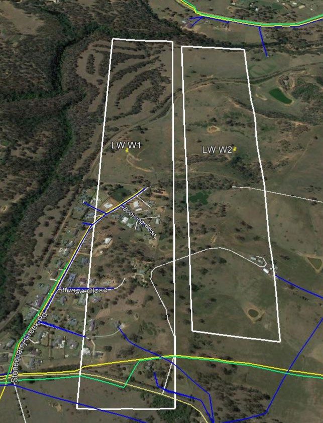
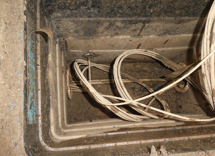
Table of Contents
1.      Introduction ............................................................................................................................................................. 5
                Background..................................................................................................................................................... 5
                Purpose and Objectives .................................................................................................................................. 5
                Scope .............................................................................................................................................................. 6
                Timeframe ...................................................................................................................................................... 8
                Limitations...................................................................................................................................................... 9
                Definitions ...................................................................................................................................................... 9
2.      Consultation .......................................................................................................................................................... 11
                Consultation with NBNCo ............................................................................................................................ 11
3.      Subsidence Predictions .......................................................................................................................................... 12
     3.1 Subsidence Predictions (Reference No 1)............................................................................................................ 12
     3.2 Geological Structures........................................................................................................................................... 13
4.      Risk Assessment .................................................................................................................................................... 14
     4.1 NSW Work Health and Safety Legislation .......................................................................................................... 14
     4.2 Risk Assessment Methodology............................................................................................................................ 15
     4.3 Risk Assessments for each Infrastructure Group ................................................................................................. 15
        4.3.1 NBNCo Local Copper Customer Distribution Cable ................................................................................... 15
        4.3.2 NBNCo Optical Fibre Cables (Telstra direct buried cable also present) ...................................................... 17
        i) NBNCo Cable in Conduit crossing LW W1 and to the south of LW W2 (Telstra Direct Buried IEN optical
        fibre cable) ............................................................................................................................................................ 17
        ii) NBNCo Cable in Conduit crossing the northern end of LW W1-W2 (Barkers Lodge Road) – (Telstra direct
        buried IEN cable also present) .............................................................................................................................. 17
        4.3.3 NBNCo Cable in Conduit along Stonequarry Creek Road (Telstra CAN cable also present in same conduit)
        ............................................................................................................................................................................... 17
        4.3.5 Manhole, Conduit and Pit Network .............................................................................................................. 19
     4.4 Identification of subsidence hazards .................................................................................................................... 19
5.      Control Procedure ................................................................................................................................................. 21
     5.1 Overview of Control Procedures ......................................................................................................................... 21
     5.2 Control for each Infrastructure Groups ................................................................................................................ 22
        5.2.1 NBNCo Local Copper Customer Distribution Cable ................................................................................... 23
        5.2.2 NBNCo & Telstra Optical Fibre Cables ....................................................................................................... 23
        i) NBNCo (2 OAK 00 00 TSS 010) optical fibre cables crossing the southern end of LW W1 and crossing to the
        south of LW W2 (Telstra (F PCTN 103) direct buried IEN co-located) ............................................................... 23
        ii) NBNCo Cable in Conduit crossing the northern end of LW W1-W2 (Barkers Lodge Road) – (Telstra direct
        buried IEN cable also present) .............................................................................................................................. 25

3 Tahmoor Mine Extraction Plan LW W1-W2: Telecommunications Management Plan for NBNCo Infrastructure
Comms Network Solutions Pty Ltd | Issue 1 | Nov 19
5.2.3 NBNCo Cable in Conduit along Stonequarry Creek Road (Telstra CAN cable also present in same conduit)
        ............................................................................................................................................................................... 25
        5.2.4 Manhole, Conduit and Pit Network .............................................................................................................. 25
     5.3 Surface Subsidence Survey.................................................................................................................................. 26
6.      Implementation...................................................................................................................................................... 29
                NBN Response Group – Roles and Responsibility....................................................................................... 29
                Audit and Review ......................................................................................................................................... 30
                Record Keeping ............................................................................................................................................ 31
7.      Associated Documents and References ................................................................................................................. 33
                Appendices ................................................................................................................................................... 33
                References .................................................................................................................................................... 33
8.      Contact List ........................................................................................................................................................... 34

4 Tahmoor Mine Extraction Plan LW W1-W2: Telecommunications Management Plan for NBNCo Infrastructure
Comms Network Solutions Pty Ltd | Issue 1 | Nov 19
1. Introduction

         Background
The Tahmoor Coal Mine (Tahmoor Mine) is an underground coal mine located approximately 80 kilometres (km)
south-west of Sydney between the towns of Tahmoor and Bargo, New South Wales (NSW). Tahmoor Mine produces
up to three million tonnes of Run of Mine (ROM) coal per annum from the Bulli Coal Seam. Tahmoor Mine
produces a primary hard coking coal product and a secondary higher ash coking coal product that are used
predominantly for coke manufacture for steel production. Product coal is transported via rail to Port Kembla and
Newcastle for Australian domestic customers and export customers.
The Tahmoor Mine has been operated by Tahmoor Coal Pty Ltd (Tahmoor Coal) since Tahmoor Mine commenced in
1979 using board and pillar mining methods and via longwall mining methods since 1987. Tahmoor Coal, trading as
Tahmoor Coking Coal Operations (TCCO), is a wholly owned subsidiary within the SIMEC Mining Division
(SIMEC) of the GFG Alliance (GFG).
Tahmoor Coal has previously mined 32 longwalls to the north and west of the Tahmoor Mine’s current pit top
location. Tahmoor Coal has recently completed mining Longwall 32 in accordance with Development Consents and
Subsidence Management Plan Approval.
Tahmoor Coal proposes to extend underground coal mining to the north-west of the Main Southern Railway (referred
to as the ‘Western Domain’) which will include Longwalls West 1 (LW W1) to West 4 (LW W4) at Picton and
Thirlmere. The first two longwalls to be mined are LW W1 and Longwall West 2 (LW W2) (collectively referred to
as LW W1-W2), which are the focus of this Extraction Plan. The location of these areas is shown in Plate 1.
As part of the planning for mining LW W1–W2, Tahmoor Coal has identified surface assets which may be affected by
the mining operation in the Picton west area. Some of these telecommunications assets belong to NBNCo and Telstra
and are part of NBNCo’s infrastructure in the area.
There are current changes underway to transfer ownership of Telstra’s external cable network progressively to
NBNCo and some of the existing communications infrastructure in this area, has been or is, progressively being
transferred to NBNCo, as they establish their new network throughout the area. Telstra will maintain ownership of
their existing main cable and conduit network while NBNCo will have ownership over their newly installed cable
network to the Node or Pillar and then to the customer’s premises. Additionally, NBNCo have installed their own
Inter Exchange Network (IEN) optical fibre cable network. Hence ownership of the telecommunications network
throughout this area, is a composite arrangement, essentially with NBNCo owning cables from the Node to the
customer as well as their IEN optical fibre cable network and with Telstra owning their existing conduit network plus
their main copper and optical fibre cables. This dual ownership provides challenges to implementing
telecommunications management plans, due in part to overlapping ownership details such as NBNCo cable within
Telstra’s conduit and pit network.
Tahmoor Coal has represented this longwall mining application for LW W1–W2 to both Telstra and NBNCo, and
each company have independently determined that they will present their own preferred management plan and
monitoring regime for their own networks to Tahmoor Coal for implementation. This management plan is to consider
the monitoring actions determined by NBNCo for their network, allowing for some minor overlap and feedback being
provided from the Telstra monitoring exercise since this has been established over the past 20 years.

         Purpose and Objectives
This NBNCo Management Plan (NBN MP) will consider the impact of the ground surface movements, contributed by
LW W1–W2 on the assets owned by NBNCo. Additionally, there is some comment in this management plan
regarding potential impacts on the adjacent Telstra network. The comments relate to planned monitoring of the Telstra
network by Comms Network Solutions Pty Ltd (CNS) which has been part of previous longwall monitoring where the
entire communications network was owned by Telstra. The commitment by CNS to NBNCo in regard to existing
monitoring regimes, as previously adopted and now applied to LW W1-W2, is to immediately provide any relevant

5 Tahmoor Mine Extraction Plan LW W1-W2: Telecommunications Management Plan for NBNCo Infrastructure
Comms Network Solutions Pty Ltd | Issue 1 | Nov 19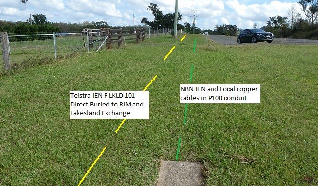
information gained by monitoring the performance of the Telstra network to NBNCo This provides the advantage to
NBNCo that CNS field staff engaged by Tahmoor Coal can immediately advise NBNCo of current ground surface
impacts, potentially affecting the co-located Telstra network which may have implications for the adjacent NBNCo
network.
It is recognised that NBNCo will be responsible for managing potential impacts on their network but this can be
augmented by CNS providing current mining status, potential anomalous ground movements and any changes noted
in the Telstra network which may prove to be of assistance to the monitoring regime established for NBNCo.
The objectives of this NBN MP in relation to NBNCo plant are to put in place procedures to be followed:
    •   To ensure the safe and serviceable operation of all surface infrastructure. Public and workplace safety is
        paramount. Ensure that the health and safety of people who may be present in the vicinity are not put at risk
        due to mine subsidence;
    •   To avoid disruption and inconvenience or, if unavoidable, kept to minimal levels;
    •   To audit and assess the relative risk, for each section of the NBNCo networks exposed to mine subsidence;
    •   To monitor the impact of mine subsidence and initiate action to mitigate potential damage to the network
        infrastructure by recording visible changes or changes in transmission characteristics which may affect plant
        performance;
    •   To provide a plan of action, should subsidence effects impact on the serviceability or performance of plant;
    •   To establish a clearly defined decision-making process to ensure timely implementation of risk control
        measures for high consequence but low likelihood mine subsidence induced hazards that involve potential for
        serious injury or illness to a person or persons that may require emergency evacuation, entry restriction or
        suspension of work activities; and
    •   To establish an NBN Response Group (NBN RG) to report, discuss and record impacts on NBNCo plant and
        transmission performance (refer to Section 6.0).

        Scope
Tahmoor Coal commissioned a report by Mine Subsidence Engineering Consultants Pty Ltd (MSEC) in support of the
Extraction Plan for LW W1-W2. The Report by MSEC 1019, Revision A, Reference No 1, is titled SIMEC Mining-
Tahmoor Coking Coal Operations - Longwalls W1 and W2- Subsidence Predictions and Impact Assessments for
Natural and Built Features due to the Extraction of Proposed Longwalls W1 and W2 in Support of the Extraction
Plan Application. This report identifies a Study Area for LW W1-W2 that considers mine subsidence impacts
bounded by the 20 mm subsidence contour line and 35o Angle of Draw for LW W1-W2. This Study Area has been
identified for LW W1–W2 in MSEC Drawing MSEC1019-18, which is attached as Appendix A, Sheet 1 and shows
the layout of the telecommunications infrastructure including Telstra and NBNCo optical fibre and copper cable
networks. (Note this drawing is being updated to more accurately reflect the installed NBNCo network.)
As mentioned, the Study Area under consideration is to the west of Picton and include the following NBNCo major
assets or shared assets:

    •   NBNCo Nodes in Stonequarry Creek Road providing interconnection from NBNCo optical fibre cable to
        copper distribution cable network in this area;
    •   NBNCo main optical fibre cable network between Picton and Tahmoor telephone exchanges along Thirlmere
        Way, (Telstra IEN cable also adjacent);
    •   NBNCo main optical fibre cable installed west from Picton along Barkers Lodge Road, (Telstra IEN cable
        also adjacent); and
    •   Telstra Pit and Pipe networks supporting some of the above cable networks throughout the mining area.
During the extraction of previous longwalls LW22 to LW32, the mining impacts from mine subsidence on the Telstra
owned network that have occurred have been managed satisfactorily from Telstra’s perspective. As mining continues
in LW W1-W2 the potential for impacts on the major network cable infrastructure will vary with regards to the
different types of telecommunications infrastructure exposed to mining. With this new mining area LW W1-W2, the

6 Tahmoor Mine Extraction Plan LW W1-W2: Telecommunications Management Plan for NBNCo Infrastructure
Comms Network Solutions Pty Ltd | Issue 1 | Nov 19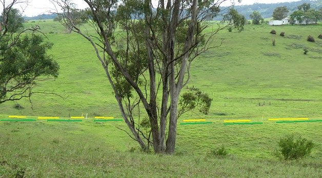
southern section of the Study Area will be associated with network in the Thirlmere Way and Stonequarry Creek
Road area and the northern section of the Study Area will be associated with Barkers Lodge Road.
The two areas present very similar telecommunications infrastructure for subsidence and ground movement
considerations. Main IEN optical fibre cables are present in the south and north. In the south however, there is also
NBNCo optical fibre cable to the Nodes and the local cable distribution is also present in the south to customers along
Stonequarry Creek Road. The Telstra manhole, pit and conduit installations support both the Telstra and NBNCo
cable networks and also cover both south and north sections of the Study Area. Therefore, the NBNCo cable networks
potentially impacted by LW W1-W2 are located in the north along Barkers Lodge Road and in the south along
Thirlmere Way and Stonequarry Creek Road.

This NBN MP is to be used to assess and protect the performance of the items in the NBNCo network identified to be
most at risk, due to mine subsidence impacts and to ensure that the health and safety of people who may be present on
public property or around NBNCo property, are not put at risk due to mine subsidence. The major items of NBNCo
plant are considered, relative to their location and risk assessed from subsidence impacts from LW W1-W2 (See
Section 4.2 -4.3).

7 Tahmoor Mine Extraction Plan LW W1-W2: Telecommunications Management Plan for NBNCo Infrastructure
Comms Network Solutions Pty Ltd | Issue 1 | Nov 19

Plate 1: Google Earth aerial view of two longwalls LW W1-W2 showing Thirlmere Way in the south and Barkers
Lodge Road in the north. The green lines indicate NBNCo optical fibre cables, south between Picton and Tahmoor
exchanges and along Stonequarry Creek Road and north along Barkers Lodge Road between from Picton and
west. The blue lines are the NBNCo local copper customer cables and the yellow lines are the Telstra IEN optical
fibre cables.

        Timeframe
Extraction from longwall LW32 was completed in October 2019 and LW W1 is anticipated to commence in
November 2019. The longwall will then take approximately 10 months to mine, working from the north to south
towards Thirlmere Way. It is anticipated that LW W2 will then commence extraction around 11 months later in
October 2020. Therefore, this NBN MP covering the longwall mining under NBNCo & Telstra plant will continue in

8 Tahmoor Mine Extraction Plan LW W1-W2: Telecommunications Management Plan for NBNCo Infrastructure
Comms Network Solutions Pty Ltd | Issue 1 | Nov 19
operation until completion of mining of LW W2, anticipated towards late 2021 and for sufficient period of time
thereafter to allow for completion of subsidence effects.

         Limitations
The mechanism of mine subsidence and its impact on the telecommunications networks have been considered over a
large number of longwall mining events in different geographic locations with different types of telecommunications
networks similar to those identified above. Previous longwalls have undermined direct buried major interstate optical
fibre cables through to undermining two pair copper cables servicing one customer. It is known that longwall mining
can impact on the transmission characteristics of optical fibre cables, older more brittle lead sheathed cables and aerial
cables. In this case, as the optical fibre cables are located across LW W1, maximum exposure of these cables is
associated with some accompanying risk to the Inter Exchange Network.
Also, as mentioned above there are both, local copper direct buried cables and cables in conduit which are potentially
vulnerable to sheath damage or high tensile loads respectively. Since monitoring has been performed on the network
during LW24 through to LW32 subsidence events, there is now some basis for assessing the performance of these
networks from past experience. Generally, as mentioned it has been found that the older lead sheathed main, junction,
and local copper cables and local aerial copper cable distribution networks are vulnerable to ground movement,
particularly the latter during exposure to ground tilting. However, within the subsidence zone for LW W1-W2 there
are no older lead sheathed copper cables or aerial customer distribution cables.
Once the mine subsidence is initiated there is no method of halting the subsidence event and hence, if the degree of
ground movement begins to damage communications plant, then the impact is irreversible and repair work is required.
This has been done in the past where, through continuous fibre monitoring, vulnerable plant has been identified to be
at risk during the event and action has been taken to minimise the risk of any continuing damage to the network. An
NBN MP will not necessarily prevent damage but will limit subsidence impact and put in place suggested actions to
be taken should evidence of significant ground movement indicate the potential for damage to occur.

         Definitions
CAN - Customer Access Network, the cable distribution network which provides communications services direct to
customers premises.
Main Cable – Main copper cable providing pairs of copper conductors between the exchange and the distribution
point or cross connect point generally a pillar location. This cable network is being superseded as NBNCo roll out
FTTN.
NBNCo FTTN - System of providing telecommunications services to the customer. NBNCo install above ground
Micro Node or VDSL (Very High Bit Rate Subscriber Line) Cabinets at the Pillar with optical fibre cable feeds to the
Node location. Copper services are then generally used customer’s side of the Node to provide data, phone and
internet services to customer’s premises. The Node will be fed by optical fibre cable from the exchange and the
distribution from the node to the customer will be by NBNCo Local copper cable network.
Local Cable – NBNCo customer local copper cable providing pairs of copper conductors between the Node
distribution point and the customer’s premises. This cable may be directly buried or installed in conduit or use aerial
distribution to the individual premises.
OTDR :- Optical Time Domain Reflectometer, used to determine loss characteristics for transmission systems on
optical fibre cables. Generally used for testing transmission quality of individual optical fibres with testing at 1625nm,
at higher frequency than transmission systems, to provide early warning of possible transmission loss on the system.
Pillar – Is the Telstra interconnection point between the local cable leading to the customer’s premises and the Main
cable from the exchange. It provides flexibility within the Customer Access Network to connect new and disconnect
cancelled services. The main telephone exchange distribution area is broken up into smaller distribution areas where
the individual pillar provides the connection between the exchange and the customer. Note that with the rollout of

9 Tahmoor Mine Extraction Plan LW W1-W2: Telecommunications Management Plan for NBNCo Infrastructure
Comms Network Solutions Pty Ltd | Issue 1 | Nov 19
NBNCo this section of the Telstra cable network will be divested from Telstra to NBNCo as NBNCo establish Nodes
as in Stonequarry Creek Road.
NBN Response Group: (NBN RG) Forum proposed to be convened as necessary (teleconference preferred) to
facilitate the implementation and discussions around the operation of this NBN MP. Participants to be from NBNCo,
Tahmoor Coal, MSEC, Comms Network Solutions and other Tahmoor Coal technical consultants as required. The
NBN RG will arrange discussions and meetings as required and where necessary involve Subsidence Advisory NSW
and the NSW Resources Regulator.
NBN Node – This is an external cabinet located generally in the road reserve as a stand-alone cross connect unit
which allows improved transmission systems in telephone, internet and data traffic to be provided to locations remote
from a telephone exchange. The transmission system into the Node is provided by optical fibre cable and the customer
feed from the Node is then generally by traditional local copper cable distribution to the customer’s premises.

10 Tahmoor Mine Extraction Plan LW W1-W2: Telecommunications Management Plan for NBNCo Infrastructure
Comms Network Solutions Pty Ltd | Issue 1 | Nov 19
2. Consultation

        Consultation with NBNCo
Colin Dove from CNS attended a meeting with NBNCo Network Deployment NSW / ACT at their Pennant Hills
Office in August 2019 to discuss the planned longwalls LW W1-W2 to be commenced by Tahmoor Coal and to
consider the implications on the NBNCo Network.
There has been follow up phone and email contact with NBNCo Technology Group where the Network Operations
and Service Delivery Sections of NBNCo are to introduce Remote OTDR monitoring on their two optical fibre cables:
a) The 144f SMOF cable, 2OAK 00 00 TSS 010 crossing LW W1 in the southern zone
b) The 144f SMOF cable, 2OAK-00-00-TSS-007 installed just within the northern Study Area for LW W1 & W2.
Tahmoor Coal will regularly consult with NBNCo in relation to mine subsidence effects from mining as required and
contact can also be supplemented through CNS who are in the field monitoring the Telstra network. This will include
regular consultation and reporting of subsidence movements and potential impact areas.
Tahmoor Coal and/or CNS will continue to consult regularly with NBNCo during the extraction of LW W1-W2 in
relation to progress of longwalls, presentation of survey data and potential mine subsidence impacts.

11 Tahmoor Mine Extraction Plan LW W1-W2: Telecommunications Management Plan for NBNCo Infrastructure
Comms Network Solutions Pty Ltd | Issue 1 | Nov 19
3. Subsidence Predictions
3.1 Subsidence Predictions (Reference No 1)
The Mine Subsidence Engineering Consultants Pty Ltd Report MSEC1019 Revision A, Reference 1, Section 6.11.4
Telecommunications Services makes the statement that:
“TCCO and Telstra have developed and acted in accordance with an agreed risk management
plan to manage potential impacts to telecommunications infrastructure during the mining of Longwalls 22 to
31. It is recommended that this management plan is reviewed and updated to incorporate LW W1-W2.”
The NBN MP will take into consideration the subsidence predictions for LW W1-W2, as well as drawing on the
experience gained from the management of the Telstra infrastructure from previous subsidence events due to LW29 to
LW32 at Tahmoor Mine.
It is recognised from past experience gained at Tahmoor Mine in monitoring the Telstra network that optical fibre
cable is more vulnerable to ground movement predominantly due to the nature of the cable in that it is only able to
sustain relatively low ground compressive and tensile strains before the external sheath transfers the strain to the
individual fibres within the cable. When this occurs, the individual fibres have limited capacity to tolerate tensile or
compressive strains before they cause interruption to or failure of transmission systems. The other concern with
optical fibre cables is that they have much larger capacity to carry telephone, data and internet services such that any
minor interruption to traffic, can cause serious impacts on the overall telecommunications network.
Generally the more extensive local copper cable network is more robust and able to tolerate reasonable levels of
mining induced ground strain. The interaction is complex since the network comprises of very small copper cable of
5 mm diameter up to larger and generally more fragile 12-20 mm diameter optical fibre cables, spread diversly in the
northern and southern sections of the Study Area. As a result the cable types will be considered within their general
groupings of cable type:
a NBNCo Local copper cable distribution in Stonequarry Creek Road;
b NBNCo optical fibre cables: (including consideration of Telstra optical fibre cables co-located)
i NBNCo and Telstra direct buried IEN optical fibre cables crossing the southern end of LW W1 and
crossing to the south of LW W2;
ii NBNCo and Telstra CAN optical fibre cable along Stonequarry Creek Road. Note, NBNCo cable
stops short of western goaf edge of LW W1 while the Telstra cable crosses into the western
extraction area of LW W1;
iii NBNCo and Telstra optical fibre cables in conduit to the north of LW W1-W2 along Barkers Lodge
Road just inside the Study Area; and
c Cable distribution network consisting of manholes, pits and conduit over the Extraction Plan Study Area
supporting both the Telstra and NBNCo cable networks.
The total subsidence predictions for these various cable types is as shown below in Table 1 extracted from Reference
No 1 as included in Appendix A Sheets 2, 3 and 4.
12 Tahmoor Mine Extraction Plan LW W1-W2: Telecommunications Management Plan for NBNCo Infrastructure
Comms Network Solutions Pty Ltd | Issue 1 | Nov 19Table 1 Maximum Predicted Cumulative Subsidence Parameters for LW W1-W2 on optical fibre and copper
telecommunications cables
Tilt Curvature Transverse Strain
Subsidence
Location of Network (Applying a factor of
mm mm/m (1/km) 10 to curvature)
NBNCo & Telstra Optical
Fibre Cable & direct buried 0.6mm/m tension
750 5.5 +0.06, -0.11
copper cable crossing LW 1.1mm/m compression
W1 and south of LW W2
NBNCo & Telstra Optical
Fibre and local copper cable 0.25mm/m tension
720 2.7 +0.025, -0.05
Stonequarry Creek Road LW 0.5mm/m compression
W1
NBNCo Optical Fibre in
conduit & Telstra direct 0.0mm/m tension
buried Optical Fibre and 20 0.0 0.0
local copper cable along 0.0mm/m compression
Barkers Lodge Rd
It is proposed that this NBN MP will initiate a broad agreement between CNS, NBNCo and Tahmoor Coal to assist in
effectively managing and addressing the monitoring issues, related to the degree of risk, assessed during mining, for
the various elements of the NBNCo network exposed to mine subsidence from LW W1-W2 extraction.
3.2 Geological Structures
There have been extensive drilling investigations to identify geological structures at coal seam level. Tahmoor Coal
commissioned an engineering geologist from Strata Control Technologies in 2018 (SCT) to undertake site inspections
and mapping of the Nepean Fault. This work has provided detailed information on the nature and location of Nepean
Fault, and second order geological structures associated with the fault. These structures are located to the east of LW
W1-W2, and it was stated by SCO (2018) that “…no significant geological structures have been identified within the
Western Domain from underground workings by TCCO”.
Tahmoor Coal has surveyed subsidence along many streets during the mining of previous Longwalls 24A to 32.
Some of these monitoring lines are located over solid, unmined coal, between the extracted longwalls and the Nepean
Fault. None of the survey lines cross first order faults, though two survey lines (Stilton Dam Line and Remembrance
Drive East Line) cross mapped second order conjugate faults. A study has been completed to ascertain whether
irregular subsidence have occurred along the survey lines. The information provides an indication of the likelihood of
irregular movements during the extraction of Longwall 32. The study found no increased subsidence, tilt or strains
were measured along the survey lines that were located over unmined, solid coal areas between the extracted
longwalls and the Nepean Fault.
Should any evidence of unpredicted movement or location of geological structures become apparent during mining
operations for LW W1-W2 this should be reported immediately to NBNCo. Also, during future mining development
works or should ‘Regional or Far Field Horizontal Ground Movements’ be recorded, this information should also be
immediately reported to the NBN RG for NBNCo to consider the impact on their network.
13 Tahmoor Mine Extraction Plan LW W1-W2: Telecommunications Management Plan for NBNCo Infrastructure
Comms Network Solutions Pty Ltd | Issue 1 | Nov 194. Risk Assessment
4.1 NSW Work Health and Safety Legislation
All persons conducting a business or undertaking (PCBUs), including mine operators and contractors, have a primary
duty of care to ensure the health and safety of workers they engage, or whose work activities they influence or direct.
The responsibilities are legislated in Work Health and Safety Act 2011 and the Work Health and Safety (Mines and
Petroleum Sites) Act 2013 and associated Regulations (collectively referred to as the ‘WHS laws’).
The Work Health and Safety (Mines and Petroleum Sites) Regulation 2014 commenced on 1 February 2015 and
contains specific regulations in relation to mine subsidence.
As outlined in the Guide by the NSW Department of Trade and Investment Mine Safety:
“a PCBU must manage risks to health and safety associated with mining operations at the mine by:
• Complying with any specific requirements under the WHS laws;
• Identifying reasonably foreseeable hazards that could give rise to health and safety risks;
• Ensuring that a competent person assesses the risk;
• Eliminating risks to health and safety so far as is reasonably practicable;
• Minimising risks so far as is reasonably practicable by applying the hierarchy of control measures, any risks
that it is are not reasonably practical to eliminate;
• Maintaining control measures; and
• Reviewing control measures.
The mine operator’s responsibilities include developing and implementing a safety management system that is used as
the primary means of ensuring, so far as is reasonably practicable:
• The health and safety of workers at the mine; and
• That the health and safety of other people is not put at risk from the mine or work carried out as part of
mining operations.”
Detailed guidelines have also been released by the NSW Department of Planning and Environment, Resources
Regulator, Mine Safety Operations (MSO, 2017).
The risk management process has been carried out in accordance with guidelines published by the NSW Department
of Planning and Environment, Resources Regulator, Mine Safety Operations (MSO, 2017). The following main steps
of subsidence risk management have been and will be undertaken, in accordance with the guidelines:
• Identification and understanding of subsidence hazards;
• Assessment of risks of subsidence;
• Development and selection of risk control measures;
• Implementation and maintenance of risk control measures, and
• Continual improvement and change management.
• Each of the above steps have been or will be conducted together with the following processes.
• Consultation, co-operation and co-ordination; and
• Monitoring and review.
This management plan documents the risk control measures that are planned to manage risks to health and safety
associated with the mining of LW W1-W2 in accordance with the WHS laws.
14 Tahmoor Mine Extraction Plan LW W1-W2: Telecommunications Management Plan for NBNCo Infrastructure
Comms Network Solutions Pty Ltd | Issue 1 | Nov 194.2 Risk Assessment Methodology
The following are the assessed relative risks associated with existing NBNCo plant within the Study Area as shown in
Appendix A Sheet 1. The items of plant have been assessed according to the probability of damage and the
consequences resulting from that damage, associated with that general category of plant. The Risk Factors (from low
to high) are shown in the attached Table 2. A summary of all risks are detailed in Table 3.
Table 2 Relative Risk Factor for NBNCo Plant
Risk Consequence
Assessment Matrix
Insignificant Minor Moderate Major Catastrophic
Almost Significant Significant High High High
Certain
Likely Moderate Significant Significant High High
Likelihood
Moderate Low Moderate Significant High High
Unlikely Low Low Moderate Significant High
Rare Low Low Moderate Significant Significant
4.3 Risk Assessments for each Infrastructure Group
4.3.1 NBNCo Local Copper Customer Distribution Cable
This cable provides connection to each customer’s premises along Thirlmere Way & Stonequarry Creek Road. The
section of cable in Stonequarry Creek Road and intersecting roads of Carramar Close, Attunga Close and Booyong
Close are all in conduit and potentially are exposed to limited subsidence impact since the conduit isolates the cable
from the ground movement. Hence the risk factor for these cables is assessed to be associated with an unlikely
likelihood, minor consequence, and overall low risk.
15 Tahmoor Mine Extraction Plan LW W1-W2: Telecommunications Management Plan for NBNCo Infrastructure
Comms Network Solutions Pty Ltd | Issue 1 | Nov 19Plate 2.1 View into typical Telstra plastic pit showing P100 conduit and NBNCo cables along Stonequarry Creek Road. However, the direct buried local cables near the southern end of LW W1 are much more exposed to ground movement than the cables in the conduit network. Hence accepting that these cables are not crossing but just entering into the goaf areas of LW W1 the risk factor is assessed to be associated with a moderate likelihood, minor consequence, and an overall moderate risk. Plate 2.1 View of Telstra No5 Pit in private property on north side of Thirlmere Way showing line of NBNCo cable towards the south east corner of LW W1. Cable is grease filled hard jacket 10/0.64 cable 16 Tahmoor Mine Extraction Plan LW W1-W2: Telecommunications Management Plan for NBNCo Infrastructure Comms Network Solutions Pty Ltd | Issue 1 | Nov 19
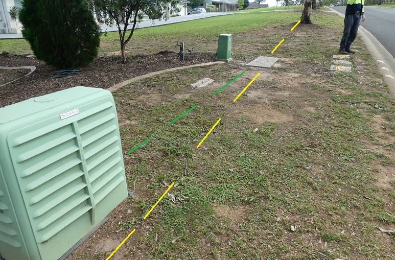
4.3.2 NBNCo Optical Fibre Cables (Telstra direct buried cable also present)
i) NBNCo Cable in Conduit crossing LW W1 and to the south of LW W2 (Telstra Direct Buried IEN optical fibre
cable)
The Telstra cable F PCTN 103 12f SMOF cable is a small diameter standard construction direct buried cable crossing
LW W1 alongside the NBNCo cable. The NBNCo cable is a 144f SMOF cable, 2 OAK 00 00 TSS 010 which is of
more robust construction that is installed in conduit alongside the Telstra cable hence being less vulnerable to ground
strain than the Telstra cable. Therefore, since the cables are installed within 3-5m of each other it is considered that
the Telstra cable being the more vulnerable of the two cables present across LW W1-W2, can be monitored to provide
early advice of potential impacts to NBNCo. The risk factor for the NBNCo cable installed in conduit is assessed as
an unlikely event with major consequence, and an overall significant risk.
ii) NBNCo Cable in Conduit crossing the northern end of LW W1-W2 (Barkers Lodge Road) – (Telstra direct
buried IEN cable also present)
The NBNCo cable is installed in Telstra conduit while the Telstra IEN cable is direct buried along the southern side of
Barkers Lodge Road, just with the LW W1-W2 Study Area. However, since there is no predicted ground strain in this
area, the only concern is far field movement and the remote possibility of potential damage to the cables. It is assumed
that since the NBNCo cable is installed in conduit it is at a much lower risk that the Telstra standard construction
direct buried cable adjacent to the conduit route. The risk factor for the NBNCo cable is assessed to be a rare
likelihood with a major consequence due to the importance of the cable and an overall significant risk. See Plate 3
below.

Plate 3 View of No 6 Pit in Barkers Lodge Road looking west towards Telstra’s RIM showing alignment of direct
buried Telstra optical fibre cable F LKLD 101 18f installed parallel with NBNCo IEN optical fibre and Telstra local
copper cables both installed in conduit.
4.3.3 NBNCo Cable in Conduit along Stonequarry Creek Road (Telstra CAN cable also present in same conduit)
These cables are installed along the western footpath alignment of Stonequarry Creek Road to the NBNCo Nodes and
to the Telstra RIM located at the northern end of Stonequarry Creek Road. The Telstra cable crosses into LW W1
diagonally from west to east. The NBNCo cable however, only extends north to the northern side of Attunga Close
and doesn’t actually enter the longwall goaf edge on the western side of LW W1. Both optical fibre cables are
installed for the full length in conduit and both cables carry the main fibre connections to the respective Nodes,
NBNCo near Attunga Close and Telstra at the northern end of Stonequarry Creek Road within LW W1.

17 Tahmoor Mine Extraction Plan LW W1-W2: Telecommunications Management Plan for NBNCo Infrastructure
Comms Network Solutions Pty Ltd | Issue 1 | Nov 19
Since the NBNCo cable is in conduit and stops approximately 100m west of LW W1 the risk factor is assessed as a
rare likelihood, with moderate consequence, and an overall moderate risk.
The Telstra cable however since it crosses for around 300m into the western goaf area of LW W1, leads to a relatively
higher risk factor than the NBNCo cable and CNS monitoring of this cable will provide feedback on the NBNCo
cable.

Plate 4 View of No5 Pit in Stonequarry Creek Road showing NBNCo(green) and Telstra optical fibre (blue) cables to
Nodes in Stonequarry Road and Telstra RIM at the northern end of the road.

4.3.4 NBNCo Nodes in Stonequarry Creek Road

Plate 5 View of NBNCo Node ‘2TAH02-07-FNO-001’ located at No 13 Stonequarry Creek Road showing NBNCo
(green) and Telstra (yellow) conduit from Telstra No6 Pit to Node and along western side of Stonequarry Creek
Road. Note NBNCo Nodes are not located over LW W1
The two NBNCo Nodes installed along Stonequarry Creek Road are not considered to be at risk due to longwall
mining. They are relatively small light weight above ground HDPE housings mounted on a No5 Pit with P100 conduit

18 Tahmoor Mine Extraction Plan LW W1-W2: Telecommunications Management Plan for NBNCo Infrastructure
Comms Network Solutions Pty Ltd | Issue 1 | Nov 19
feeding into the pit from the adjacent Telstra pit. Additionally, the Nodes are located up to 100m from the western
goaf edge of LW W1. Therefore, the risk factor is assessed to be Rare likelihood with Minor consequences, risk factor
for NBNCo Node is Low.
4.3.5 Manhole, Conduit and Pit Network
The conduit, manhole and pit network are a critical factor in the performance of the cable network during mine
subsidence. Although the possibility of differential movement between the components of this network, due to mine
subsidence is low, due to the large geographical extent of the network, its lack of homogeneity and its differing age, it
is considered to be an important factor in the performance of the entire cable network. The conduit, manholes and pits
provide the primary isolation of the cable network from ground movement and strain. In addition, because of the
variation in the components of this network it is also the most difficult item of plant to assess for potential risk of
damage.
The main concern in this network is the performance of the older larger asbestos and cellulose fibre pits, however
these are only present outside of the direct mining areas along Thirlmere Way and Barkers Lodge Road. The large pits
along Stonequarry Creek Road are all HDPE (polyethylene) construction making them far less vulnerable to ground
movement impacts than the heavier asbestos or concrete pits located in adjacent areas. All of the conduit network
utilises varying sized PVC conduit (20-100 mm dia.) which is considered to be at a low level of risk of damage from
ground movement or strain. The risk assessment for the manhole, conduit and pit network is considered to be
associated with an unlikely likelihood, minor consequence, and an overall low risk.

4.4 Identification of subsidence hazards
Clause 34 of the Work Health and Safety Regulation (2017) requires that the duty holder (in this case Tahmoor Coal),
in managing risks to health and safety, must identify reasonably foreseeable hazards that could give rise to risks to
health and safety.
This section of the management plan summarises hazards that have been identified in the mining operation which
could raise risks to health and safety of people in the vicinity of NBNCo and Telstra infrastructure.
Mine subsidence hazards have been identified, investigated and analysed in a systematic manner by examining each
aspect of the infrastructure, as described in Section 4.3.1 to 4.3.5 above of this management plan. Each of the
infrastructure groups discussed above could potentially experience mine subsidence movements that give rise to risks
to the health and safety of people.

The following mine subsidence hazards were identified that could give rise to risks to health and safety due to the
extraction of LW W1-W2:
    •    Temporary loss of telecommunication IEN or CAN services;
    •    Tensile or compressive ground strain acting on direct buried cables; and
    •    Disruption of telecommunication services into or out of Nodes.
The identification and risk assessment process took into account the location of infrastructure relative to LW W1-W2
and the associated timing and duration of the subsidence event, as described in this management plan.
Whilst mine subsidence predictions and extensive past experiences from previous mining at Tahmoor Coal were taken
into account, the identification and risk assessment process recognised that there are uncertainties in relation to
predicting subsidence movements, and uncertainties in how mine subsidence movements may adversely impact
NBNCo and also Telstra infrastructure. In this case, creeks and geological structures have been mapped that intersect
both the NBNCo and Telstra infrastructure where higher ground strains may occur.
Tahmoor Coal has considered the outcomes of the hazard identification and risk assessment process when developing
measures to manage potential impacts on the health and safety of people, and potential impacts on NBNCo and
Telstra infrastructure in general. These details are described in Section 5 of this management plan.

19 Tahmoor Mine Extraction Plan LW W1-W2: Telecommunications Management Plan for NBNCo Infrastructure
Comms Network Solutions Pty Ltd | Issue 1 | Nov 19
In addition to the risk assessment process outlined in this NBN MP, a Risk Assessment was completed by Tahmoor Coal for LW W1-W2 Infrastructure on 26 March 2019, which included the identification of potential risks to NBNCo infrastructure (refer to Appendix B and Appendix C). 20 Tahmoor Mine Extraction Plan LW W1-W2: Telecommunications Management Plan for NBNCo Infrastructure Comms Network Solutions Pty Ltd | Issue 1 | Nov 19
5. Control Procedure

5.1 Overview of Control Procedures
Tahmoor Coal has developed and selected risk control measures in consultation, co-ordination and co-operation with
the infrastructure owner in accordance with WHS legislation. In accordance with Clauses 35 and 36 in Part 3.1 of the
Work Health and Safety Regulation 2017 and the guidelines (MSO, 2017), a hierarchy of control measures has been
considered and selected where reasonably practicable, using the following process:
    •   Eliminate risks to health and safety so far as is reasonably practicable;
    •   If it is not reasonably practicable to eliminate risks to health and safety – minimise those risks so far as is
        reasonably practicable, by doing one or more of the following:
             o   Substituting (wholly or partly) the hazard giving rise to the risk with something that gives rise to a
                 lesser risk;
             o   Isolating the hazard from any person exposed to it;
             o   Implementing engineering controls;
    •   If a risk then remains, minimise the remaining risk, so far as is reasonably practicable, by implementing
        administrative controls; and
    •   If a risk then remains, the duty holder must minimise the remaining risk, so far as is reasonably practicable,
        by ensuring the provision and use of suitable personal protective equipment.
    •   A combination of the controls set out in this clause may be used to minimise risks, so far as is reasonably
        practicable, if a single control is not sufficient for the purpose.
There are primarily two different methods to control the risks of subsidence, namely:
    •   Method A – Selection of risk control measures to be implemented prior to the development of subsidence,
        (Items 1 and 2 above), and
    •   Method B – Selection of risk control measures to be implemented during the development of subsidence
        (Items 3 and 4 above).
Tahmoor Coal considered Method A and Method B risk control measures in relation to managing potential impacts on
NBNCo infrastructure due to the extraction of LW W1-W2.
The following considerations have been made by Tahmoor Coal with regards to impact to telecommunication
infrastructure:
    •   Elimination - In this instance, no reasonably practicable controls could be identified that would eliminate the
        identified risks;
    •   Substitution - In this instance, no reasonably practicable controls could be identified that will change the
        environment so the hazards could be substituted for hazards with a lesser risk;
    •   Isolation - In this instance, no reasonably practicable controls could be identified to isolate a hazard from any
        person exposed to it;
    •   Engineering Controls - In this instance, no reasonably practicable controls could be identified to put in place
        a structure or item that prevents or minimises risks; and
    •   Administrative Controls - Tahmoor Coal and NBNCo have developed and implemented Administrative
        Controls that will put in place procedures to minimise the potential of impacts on the health and safety of
        people associated with damage to NBNCo infrastructure.
Tahmoor Coal and NBNCo have developed a management strategy of detecting early the development of potential
adverse subsidence movements in the ground, so that contingency response measures can be implemented before
impacts on the safety and serviceability develop. See Table 3 of this NBN MP.

21 Tahmoor Mine Extraction Plan LW W1-W2: Telecommunications Management Plan for NBNCo Infrastructure
Comms Network Solutions Pty Ltd | Issue 1 | Nov 19
The risk control measures described in this NBN MP have been developed to ensure that the health and safety of people on NBNCo infrastructure are not put at risk due to mine subsidence. It is also an objective to avoid disruption to services, or if unavoidable, keep disruption and inconvenience to minimal levels. With respect to the extraction of LW W1-W2, no potential hazards have been identified that could reasonably give rise to the need for an emergency response. Of the potential hazards identified, only a complete loss of mobile and fixed line services could possibly give rise to the need for an emergency response. The likelihood is considered remote and would require substantial differential subsidence movements at multiple locations to develop before such an event occurs. Mine subsidence movements will develop gradually and there will be ample time to identify the development of potentially adverse differential subsidence movements early, consider whether any additional management measures are required and repair or adjust affected surface features, in close consultation with NBNCo. Tahmoor Coal and NBNCo will review and assess monitoring reports and consider whether any additional management measures are required on a weekly basis. If potentially adverse differential subsidence movements are detected, it is anticipated that a focussed inspection will be undertaken in the affected area, and a decision will likely be made to increase the frequency of surveys and/or inspections. Additional management measures may also be implemented. It is therefore expected that, as a potential adverse situation escalates, Tahmoor Coal will be present on site on a more frequent basis to survey or inspect the affected site, and that NBNCo will be consulted on a more frequent basis. Notwithstanding the above, if a hazard has been identified that involves potential serious injury or illness to a person or persons on public property or in the vicinity of NBNCo infrastructure, and cannot be controlled, the immediate response is to remove people from the hazard. If such a situation is observed or is forecast to occur by either Tahmoor Coal or by people on public property, Tahmoor Coal NBNCo will immediately meet and implement emergency procedures through the NBN RG. 5.2 Control for each Infrastructure Groups There is now information available on the general performance of Telstra telecommunications plant due to ground subsidence caused by longwall mining operations in the past. The current information available is from experience gained at Appin, Tahmoor / Thirlmere, Appin, Helensburgh, West Wallsend, Camberwell and Broke in NSW. The longwall mining operation at Thirlmere / Tahmoor provides a continuing opportunity to gather information on the performance of the network, needed to understand the interaction between ground movement and the Telstra or NBNCo networks, comprising both robust and also relatively sensitive elements of the network. This information is provided in this NBN MP for the benefit of NBNCo through the experience gained by CNS over 20 years of ‘in the field’ monitoring of Telstra’s extensive telecommunications network throughout the large geographic areas identified above The general control procedure considered in this NBN MP is to look at each item of plant described in Section 4.3.1 to 4.3.5 and determine the practical level of monitoring that can be performed according to the assessed risk factor applied. The monitoring described for the plant identified should be completed during the ground subsidence events occurring at the particular location as the longwall progresses. In addition, Table 3 is a summary of recommendations for monitoring procedures and basic actions to be taken during mining, should the potential for damage be indicated by surface impacts, cable testing or from survey data. Since there are similar types of cable involved and the proposed monitoring methods for each cable type are similar, they have been grouped together below and in Table 3 to simplify the discussion and proposed management of the network during ground subsidence. 22 Tahmoor Mine Extraction Plan LW W1-W2: Telecommunications Management Plan for NBNCo Infrastructure Comms Network Solutions Pty Ltd | Issue 1 | Nov 19
5.2.1 NBNCo Local Copper Customer Distribution Cable
(Risk Factor. Unlikely/ Minor, low risk in a conduit; Moderate / Minor, moderate risk directly buried)
The NBNCo local copper customer cables located in Thirlmere Way, Stonequarry Creek Road and intersecting roads
of Carramar Close, Attunga Close and Booyong Close are all in conduit and are exposed to limited subsidence
impacts since the conduit isolates the cable from the ground movement and it is only at the northern end of
Stonequarry Creek Road that the network enters LW W1.
The maximum predicted subsidence at the northern end of Stonequarry Creek Road is 700 mm with Tilt of +/– 2
mm/m and Ground Strain 0.5 mm/m compression to 0.2 mm/m tension. From previous experience with the
performance of cables, pits and conduit network during subsidence events the risk of damage is very low in this
situation. The control method is to inspect the relevant sections of the network concurrent with analysing survey data
which will indicate anomalous ground movement behaviour, to specifically target inspection areas at specific stages of
extraction of the longwalls.
The local NBNCo copper cable into the eastern edge of LW W2 was not able to be inspected at the time of
preparation of this NBN MP. It is suggested by Tahmoor Coal that the rural property over LW W2 that this cable
feeds is to an unoccupied property that may be developed in the future. This cable needs to be surveyed to identify the
type of cable and the location of the cable relative to the edge of extraction of LW W2 and if indeed the cable is in
use. Should this cable enter the eastern extraction edge of LW W2 then specific monitoring action may be required to
monitor impacts on this cable. This may involve survey of the cable line and or liaison with the property owner to
monitor any change in the operation of their service, As identified above the risk factor of this particular cable is
associated with a moderate likelihood, minor consequence, and an overall moderate risk and detail of the cable type
and specific location is required to be positively established prior to mining of LW W2 in October 2012.
5.2.2 NBNCo & Telstra Optical Fibre Cables
i) NBNCo (2 OAK 00 00 TSS 010) optical fibre cables crossing the southern end of LW W1 and crossing to the
south of LW W2 (Telstra (F PCTN 103) direct buried IEN co-located)
(Risk Factor, Moderate / Major - high risk).
The two cables NBNCo 144f SMOF cable, 2 OAK 00 00 TSS 010 is believed to be installed in conduit alongside the
direct buried Telstra cable F PCTN 103 12f SMOF both located approximately 80m to the south of LW W2 and
across the southern end of LW W1 approximately 160 m inside the longwall from the finishing end. The two cables
for the majority of this section of the route are installed within three to five metres of each other. The NBNCo cable at
144f is a more robust hard jacketed cable at more than twice the size of the standard construction Telstra optical fibre
cable. The route of both cables across the longwalls is to the north by an average of around 150 m from Thirlmere
Way through undulating rural land as shown in Plate 1 and Plate 6 below.

23 Tahmoor Mine Extraction Plan LW W1-W2: Telecommunications Management Plan for NBNCo Infrastructure
Comms Network Solutions Pty Ltd | Issue 1 | Nov 19
You can also read