MAPPING THE POTENTIAL DISTRIBUTION OF FROZEN GROUND IN TUCARROYA (MONTE PERDIDO MASSIF, THE PYRENEES) - Publicaciones Universidad de La Rioja
←
→
Page content transcription
If your browser does not render page correctly, please read the page content below

Cuadernos de Investigación Geográfica
                                                  2020     Nº 46 (2)      pp. 395-411       eISSN 1697-9540
Geographical Research Letters
DOI: http://doi.org/10.18172/cig.4414                                               © Universidad de La Rioja

  MAPPING THE POTENTIAL DISTRIBUTION OF FROZEN
 GROUND IN TUCARROYA (MONTE PERDIDO MASSIF, THE
                   PYRENEES)

                                  E. SERRANO1*, A. PISABARRO1, J.I. LÓPEZ-MORENO2,
                                    M. GÓMEZ-LENDE1, R. MARTÍN-MORENO3, I. RICO4

                                             1
                                               Dept. Geography, GIR PANGEA, University of Valladolid, Spain.
        2
         Dept. of Geoenvironmental Processes and Global Change, Instituto Pirenaico de Ecología, Consejo Superior
          de Investigaciones Científicas (IPE-CSIC), Campus de Aula Dei, P.O. Box 13.034, 50080 Zaragoza, Spain.
                                        3
                                         Dept. Didácticas Específicas, Universidad Autónoma de Madrid; Spain.
                  4
                    Dept. of Geography, Prehistory and Archaeology, University of the Basque Country, Spain.

         ABSTRACT. This paper shows the creation of a map of frozen ground
         potential for the Tucarroya valley in Ordesa National Park. To create this
         map, it was necessary to combine the identified landforms associated to the
         presence of frozen ground by fieldwork, ground temperature data continuously
         recorded during two years by automatic loggers, a Basal Temperature of
         Snow (BTS) survey, and predictor variables derived from a high resolution
         Digital Elevation Model (DEM). Four environments have been differentiated:
         unfrozen ground, seasonal frozen ground, possible permafrost and probable
         permafrost. The map confirms a very limited variety and extension of permafrost,
         above 2700 m a.s.l. on gentle and shadowed slopes. Seasonal frozen ground
         is the most common thermal regime, as it can be developed above 2500 m a.s.l.
         Snow-pack duration and thickness tightly control the duration of frozen
         ground and the freezing-thawing cycles. Frost activity and unfrozen ground is
         restricted from 2570 to 2750 m a.s.l.

         Cartografía de la distribución potencial del suelo helado en Tucarroya (Macizo
         de Monte Perdido, Pirineos)
         RESUMEN. Este trabajo describe la metodología utilizada para cartografiar los
         suelos potencialmente helados en el valle de Tucarroya, en el Parque Nacional de
         Ordesa. Para cartografiar las formas asociadas a la presencia de hielo se com-
         binó trabajo de campo, datos térmicos procedentes de sensores automáticos de
         temperatura del suelo y mediciones de la base del manto de nieve (BTS), así como
         variables predictivas obtenidas de un Modelo Digital de Elevaciones (MDE). La
         cartografía diferencia cuatro ambientes, suelo no congelado con actividad de la
         helada, suelos helados estacionales, permafrost posible y permafrost probable. El
         mapa revela una extensión del permafrost muy limitada, con escasez de formas
         asociadas. Solo se ha detectado por encima de los 2700 m de altitud en ambientes

Cuadernos de Investigación Geográfica 46 (2), 2020, pp. 395-411                                             395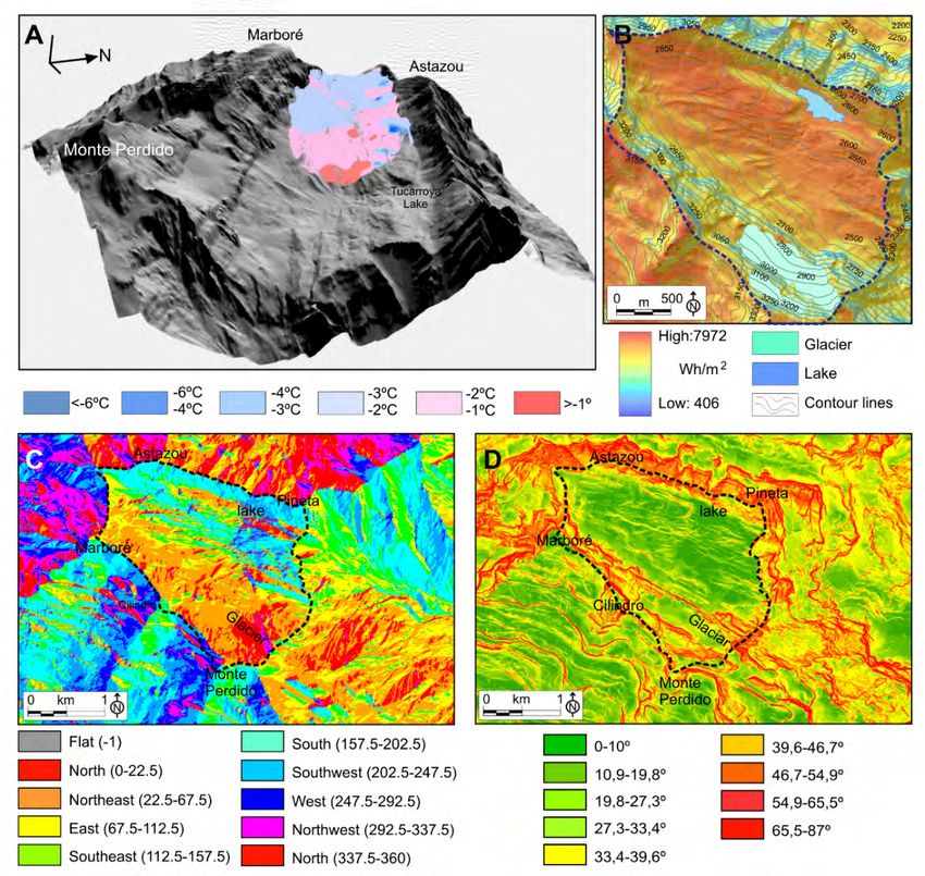
Serrano et al.

         topográficos favorables, pendientes suaves y protegidos de la radiación solar. Los
         suelos helados estacionales son los ambientes más comunes y se desarrollan por
         encima de los 2500 m s.n.m., mientras los suelos no congelados, pero con heladas
         solo están presentes entre los 2570 y los 2750 m de altitud en laderas que reciben
         elevada radiación solar.

         Key words: Frozen ground, permafrost, mapping, Pyrenees.
         Palabras clave: suelos helados, permafrost, cartografía, Pirineos.

                                                                         Recibido:8 November 2019
                                                                        Aceptado: 31 December 2019

*Corresponding author: Enrique Serrano, Dept. of Geography, GIR-PANGEA,
University of Valladolid, Spain. E-mail address: serranoe@fyl.uva.es

1. Introduction

     Knowledge of the frozen ground distribution and its typology leads to an improved
understanding of the geomorphology, hydrology and ecology of cold environments.
The presence of ice in the ground is closely linked to vegetation, soil formation or
degradation and changes in the biotopes. Permafrost is commonly mapped in high
mountain areas to observe the potential distribution of mountain permafrost (Gruber
and Haeberli, 2009; Haeberli et al., 2010). Different modelling techniques have been
applied to map permafrost in the world’s main mountains (Hegimbottom et al., 2002;
Boeckli et al., 2012). On small spatial scales the existence of active rock glaciers are
the main indicator of permafrost. However, on larger scales and in places where rock
glaciers do not exist other elements can be used, though with greater uncertainty
and inaccuracy in the delineation of existing frozen grounds. Therefore, different
indicators based on fieldwork, monitoring and remote sensing permit detailed maps
of frozen ground distribution to be made in relatively small areas (Zhang et al.,
2014).
     Maps of frozen ground are a useful tool not only to know the mountain cryosphere
and to understand geomorphic processes related to the active layer and landform
distribution. They also lead to an understanding of the thermal setting of habitats
and geosystems, as well as the ice and frost activity to take into consideration in
ecological studies in high mountain areas. Their relationships with species living
at high altitude, such as extremophiles, mammals, birds or plants, are determined
by seasonal or permanent frozen grounds. The snow distribution and snow-cover
persistence during summer is also influenced by frozen ground. Frozen ground maps
are evidently of interest to geoecological and ecological studies, and particularly in
natural protected areas (NPA) where knowledge, protection and conservation are
priority aims.
    Tucarroya Cirque belong to the Ordesa-Monte Perdido National Park, the
second National Park to be declared in Spain (1918), which was extended to include

396                                     Cuadernos de Investigación Geográfica 46 (2), 2020, pp. 395-411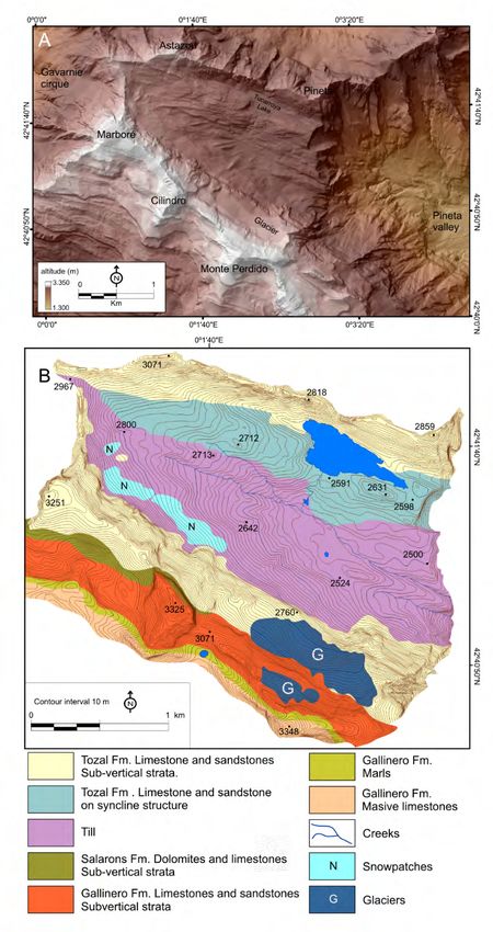
Mapping the potential distribution of frozen ground

the summits and Tucarroya cirque in 1982. The study area has also been included
in the wider Unesco Biosphere Reserve of Ordesa-Vignemale (M&B Program)
since 1977, and was declared World Heritage Site by Unesco in 1997 (Martínez de
Pisón et al., 2001). It is therefore a territory of natural heritage value, and managers,
policy-makers and authorities need to know about its habitats, ecosystems and
geosystems. The cryosphere is a key element at higher altitudes and a symbol of
landscape and nature conservation in the Pyrenees. The cryosphere of the National
Park includes four glaciers, including the Monte Perdido Glacier, the second largest
in the Pyrenees, and more than a dozen of ice caves, among them the famous Casteret
ice cave (Martínez de Pisón and Arenillas, 1988; García-Ruiz and Martí-Bono,
2001, López-Moreno et al., 2016, 2019; Rico et al., 2017; Serrano et al., 2018b).
Nevertheless, frozen grounds are the most widespread element of the cryosphere,
after the winter snow-cover.
      Periglacial environments and their dynamics have been studied in the Pyrenees
mainly in relation to the mapping of landform, and particularly focused on rock glaciers
(Serrano et al., 1999; 2001, 2009; 2018a; Oliva et al., 2016, 2018). Maps of permafrost
distribution were made in Posets Massif, differentiating among sporadic, discontinuous
and continuous permafrost (Serrano et al., 2001; Lugon et al., 2004). The spatial
distribution of mountain permafrost was obtained around the Aneto peak by means of the
Inverse Distance Weighting (IDW) interpolation model (Chueca and Julián, 2010), and
thermal and permafrost maps have been made in the Alba-Maladeta, Infiernos Massif
and La Paúl Cirque (González-Garcia, 2013; Serrano et al., 2019). The entire Pyrenees
was mapped on a scale 1:500,000 also using an IDW interpolation model (Serrano
et al., 2009). The map differentiated between possible and probable permafrost and
showed the potential occurrence of permafrost environments in all massifs higher than
3000 m a.s.l. In the Pyrenees attention has been paid to mountain permafrost and its
distribution, but not to the presence of seasonally frozen ground (SFG), nor its distribution
and relationships with freeze and thaw processes in the periglacial and paraglacial high
mountain environment.
      The aim of this work is to know the distribution of periglacial environments and to
map the Tucarroya area in detail such that frozen ground, SFG and permanently frozen
ground, can be represented. The map integrates information on periglacial landforms and
processes, ground thermal regimes, medium annual and winter ground temperatures and
topoclimatic variables such as altitude, slope, aspect, and potential radiation. This is the
first detailed scale map on frozen ground in the National Park and it is the first map to
include SFG.

2. Study site

     The Tucarroya valley is located in the central Pyrenees between the Monte-Perdido-
Marboré range (Monte Perdido Peak, 3295 m a.s.l.) to the south and the Astazou range
to the north, both over 3000 m a.s.l. (Fig. 1). It is a broad hanging valley located between
2450 to 3335 m a.s.l. (Fig. 1A).

Cuadernos de Investigación Geográfica 46 (2), 2020, pp. 395-411                                             397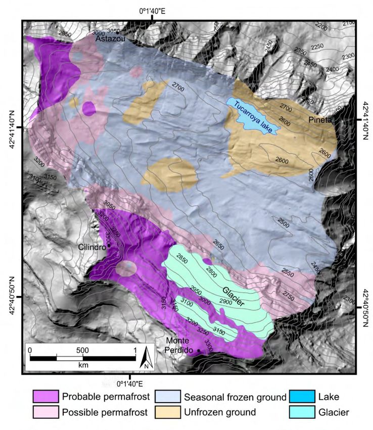
Serrano et al.

      Pleistocene glaciers have shaped the valley to form a wide glacial cirque with
overdeepening basin, glacial bars, and frontal and lateral moraines (Nicolás, 1981;
García-Ruiz and Martí-Bono, 2001; Martín-Moreno, 2006; López-Moreno et al., 2016).
The northern area, around the Tuvarroya Lake, was free of ice before 12.7 ka BP (Valero
et al., 2013; García-Ruiz et al., 2014; Leunda et al., 2017), but the central and southern
areas, included the north-facing slopes of Monte Perdido and Marboré, was occupied by
glaciers during the middle Holocene (García-Ruiz et al., 2014) and the Little Ice Age,
when several periods of advance or surges happened (Nicolás, 1981; Martínez de Pisón
and Arenillas, 1988; Serrano and Martín-Moreno, 2018; Oliva et al., 2018). Periglacial
studies have been carried on Monte perdido and Tucarroya, mainly focused on patterned
ground (Barrère, 1952; Boyé, 1952; Nicolás, 1981; García-Ruiz and Martí-Bono, 2001;
Martín-Moreno, 2006).

 Figure 1. Location of the Tucarroya. A. In the Iberian Peninsula. B. topographic map of the
                                         study area.

     The climate at the front of the Monte Perdido Glacier (2780 m a.s.l.) is
defined by an annual precipitation estimated to exceed 2000 mm yr-1 and an average
summer temperature of 7.3ºC (López-Moreno et al., 2019). The snowpack lasts
from October-November to late May-early July, and scattered snow-patches remain
throughout the year on its slopes. López-Moreno et al., (2019) have estimated the
0ºC isotherm at ~2950 m a.s.l. and reported a deep snowpack over the glacier and
surrounding areas.
     The structural relief is made up of a succession of overturned folds and thrust of
southern vergence, the Monte Perdido Thrust. The substrate is formed by alternating
limestones, marls, sandstones and dolomites (Fig. 2) of the Cretaceous age (Ríos et al.,
1989; García Ruiz and Martí Bono, 2001).

398                                     Cuadernos de Investigación Geográfica 46 (2), 2020, pp. 395-411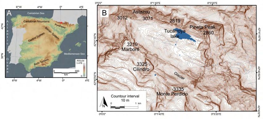
Mapping the potential distribution of frozen ground

               Figure 2. DEM (A) and Lithological sketch (B) of the Tucarroya área.

Cuadernos de Investigación Geográfica 46 (2), 2020, pp. 395-411                                             399
Serrano et al.
3. Methods
The geomorphological map of this paper shows periglacial landforms mapped
in the field by the aid of colour orthorectified images corresponding to sheet 146-4
of the Spanish topographic map (1:25,000) (fot-06-5944, 5945, 5946, 5947) (PNOA,
2015). Besides, this type of mapping can be combined with information of periglacial
thermal processes to define landsystems (Evans et al. 2017). The altitudinal thermal
classification of landforms (González-García, 2013; Serrano et al., 2019) permits us
to considerate as permafrost or SFG indicators four of the mapped landforms (Table
1).
Table 1. Periglacial processes and landforms analyzed in Tucarroya cirque.
Altitude
Processes Landforms Orientation Indicators
m
Debris talus and
3040-2555 N, S Freeze-thaw
Frost cracking cones
Crest and ridges 2700-3300 -- Freeze-thaw
Nival pavements 2950-2500 -- Freeze-thaw
Nivation
Nivokarst landforms 3100-2500 -- No frost
Debris flow 2700-2500 S No frost
Mass movement
Terracettes 2650-2490 N, S, E Freeze-thaw
Gelifluction and Debris lobes 3030-2520 N, NE, NW, SE SFG
frozen ground
creep Protalus lobes 2900-2850 N Permafrost
Frost mounds 2850-2760 Flat areas Permafrost
Cryoturbation
Patterned grounds 2790-2530 Flat areas SFG
Surface ground temperatures (GTS) and the ground thermal regime were
monitored by means of 18 continuous data-loggers (Ibuttons DS1922L and DS1921G)
placed at depths of between 2 and ~10 cm between 2014 and 2016. Dataloggers were
distributed from 2585 m a.s.l. to 3075 m a.s.l., and recorded data at four-hourly intervals
within a resolution of ± 0.5°C. The occurrence of permafrost or seasonally frozen
ground (SFG) was estimated using mean annual ground temperature (MAGT) and
mean winter ground temperature (MWGT). MAGT and MWGT allow to differentiate
areas with permafrost from other areas with SFG o without frozen ground but with
freeze and thaw alternance. They indicate SFG or permafrost when the MAGT isMapping the potential distribution of frozen ground
distribution on the ground by means of the ground thermal map of Tucarroya (Serrano
et al. 2020).
The most common permafrost maps are based on a spatial classification of permafrost
(continuous, discontinuous and sporadic) but also in the degree of certainty about its
existence (possible and probable, Table 2) and combine field observations and semi-
empirical models (Keller, 1992; Hoetzle et al., 1993; Keller et al., 1998; Heginbottom,
2002; Boeckli et al., 2012; Zhang et al., 2014; Bockheim, 2015). Alpine permafrost
distribution can be statistically differentiated as probable or possible permafrost (Hoetzle
et al., 1993; Keller et al., 1998; Heginbottom, 2002). Modelling techniques with GIS, using
predictors derived from a DEM and validated by GTS and BTS measurements permit the
presence or distribution of cryogenic processes and frozen ground to be established (Keller,
1992; Hoelzle, 1996; Gruber and Hoelzle, 2001; Heginbottom, 2002; Janke, 2005; Lambiel
and Pieracci, 2008; Serrano et al., 2009; González-García et al., 2014).
Table 2. Indicators of mountain frozen ground types and periglacial environments.
Morphogenetic MAAT MAGT MWGT
Permafrost Ground conditions
indicators ºC ºC ºC
Rock glaciers
Protalus lobes* North orientations
Probable Permanent iceSerrano et al.
Figure 3. Ground conditions in the Tucarroya. A, Ground temperature distribution from BTS
measurements. B, solar radiation map. C, aspects map. D, slopes map. Dotted line, limit of
studied area.
Finally, the potential distribution of frozen grounds map was drawn through the
layer overlapping.
4. Results and discussion
The periglacial mapped features reveal the scarcity of periglacial landforms,
both in quantity, variety and extension (Fig. 4). The dominant processes -frost
weathering, nivation, gelifluction and cryoturbation- do not necessarily confirm
the presence of SFG or permafrost. The periglacial landforms that indicate ice
activity or frozen ground in Tucarroya can be grouped into three genetic types,
shown in Table 3.
402 Cuadernos de Investigación Geográfica 46 (2), 2020, pp. 395-411Mapping the potential distribution of frozen ground
Figure 4. Location of periglacial landforms, BTS measurements, the automatic meteorological
station and datalogger in Tucarroya.
Data from temperature data-loggers revealed that snow-cover lasts at least six months
above 2580 m a.s.l., 7-8 months over 2700 m a.s.l., and 8.5 months over 2750 m a.s.l. Thus,
the snow-pack is essential to insulate the ground from the air. Snow could be the main element
in determining the ground thermal regime as well as a key driver of several geomorphological
features such as protalus processes and gelifluction (Serrano et al., 2019).
Cuadernos de Investigación Geográfica 46 (2), 2020, pp. 395-411 403Serrano et al.
Table 3. Genetic types of frozen ground activity detected in the Tucarroya Cirque.
MAGT Altitude
Ice activity Processes Landforms
ºC m a.s.l.
Frost weathering
Ground freeze- Debris cones
Frost cracking 2/-7 3040-2555
thaw cycles Debris talus
Rockfall
Stone-banked lobes 0/-4
SFG with ground Gelifluction 3030-
Terracettes 1.5/6
freeze-thaw cycles 2490
Cryoturbation Patterned ground 2/-2
Presence of frozen Cryoturbation Frost mounds 0/-4 2900-
bodies Creep Protalus lobe 0/-2 2700
Between the three types of ground thermal regime that define the study area (Serrano
et al., 2019; Table 4), the most extensive one is the climate-controlled thermal regime,
which occupies a broad part of the valley bottom and mainly on south-facing slopes. The
frozen ground-controlled regime is located in the upper parts of the slopes and summit
areas, always above 2650 m a.s.l. The ground thermal regime defines the periglacial
environments represented on the map, although several of them can co-exist at the same
altitudes.
Table 4. Ground thermal regimes
Altitude
Ground thermal regime type Thermal state Processes
m
MAGT >0ºC, Unfrozen ground Frost weathering
Climate High correlation with 3075 Freezing and
-controlled air temperature 2800 throughout the year thawing
Frost weathering
Snow-cover Ground insulation by 2785 Zero curtain effect Freezing and
controlled the snow-cover 2585 ~0ºC for 6 to 8 months thawing
3020 Frozen ground over 4-6 months.
Frozen 3000 MWGT: -4ºC/-5.9ºC
Low correlation with Permafrost
ground- Ground T 0ºC. Freeze-thaw cycles occurs
mainly during autumn, before the ground is insulated by the snow-cover. The
404 Cuadernos de Investigación Geográfica 46 (2), 2020, pp. 395-411Mapping the potential distribution of frozen ground
ground temperature depends on the snow-cover depth, working as an efficient
insulator, with a zero-curtain effect (temperature is ~0ºC) for 6 to 8 months. This
ground environment extends from 2570 to 2750 m a.s.l. Several sites where the
snow-pack is shallow due to wind blowing exhibited a high correlation between
ground and air temperatures.
– Seasonally frozen ground. It is the most extended ground environment.
Gelifluction and cryoturbation are the most common processes on
sedimentary formations and frost weathering over subtract and walls.
Processes shaping stone-banked lobes, terracettes and patterned ground are
very efficient because of the combination of frost weathering and frozen
ground. Correlation between ground and air temperatures is low. Ground
freezes and melts every year, remaining frozen between 4 and 6 months.
The MAGT has a thermal range from 2ºC to -4ºC with MWGT from -4ºC
to -5.9ºC. Ground temperatures below 0ºC last between 2 and 5 months.
This environment extends from 2400 to 3000 m a.s.l., although it is more
common above 2500 m a.s.l.
– Possible permafrost. It is located in a narrow band close to the north face
of the Monte Perdido-Marboré range. Gelifluction and cryoturbation are the
processes indicating frozen ground, shaping frost mounds and stone-banked
lobes. These landforms are distributed from 2700 to 2900 m a.s.l., always
on moraines and flat north-facing areas. The stone-banked lobes have a
wide altitudinal range and aspects N, S, NE and SE. The ground and air
temperature have a low correlation, with MAGTSerrano et al.
Figure 5. Ground environments of the Tucarroya.
Some periglacial landforms as patterned ground, are located on areas
with unfrozen ground and SFG, showing a disequilibrium with the present-day
morphoclimatic conditions. Landforms are inherited of ancient climate conditions
and processes are inactive. So, a marginal periglacial environment can be recognized
in the low areas of Tucarrroya, as it has been showed in the Alps (Delaloye, 2004).
The marginal conditions can be related to the environmental changes caused by the
elevation of the atmospheric isotherms derived from climate change. If the present-
406 Cuadernos de Investigación Geográfica 46 (2), 2020, pp. 395-411Mapping the potential distribution of frozen ground
day climate evolution is kept, changes in the permafrost and SFG environments can
be presumed, and marginal areas, where the atmospheric and ground thermal state are
in disequilibrium, will be wider.
5. Conclusions
The resulting map presents four different ground periglacial environments. The
identification of the main periglacial processes and landforms has been the starting
point; and the incorporation of GTS and BTS measurements, and the topoclimatic
factors -solar radiation, slope, orientation, and altitude- by mean of GIS techniques,
have allowed represent the ground periglacial environment. Frost weathering, nivation,
gelifluction and cryoturbation are particularly linked to the presence of frozen ground.
They were used to detect the occurrence of frozen ground. BTS and GTS measurements
and topoclimatic factors provided the spatially distributed data to be represented on a
map.
The map includes four ground environments, “unfrozen ground with frost activity”,
“Seasonally frozen ground”, “Possible permafrost”, and “Probable permafrost”. All
of them are representative of the different ground thermal regimes and geomorphic
processes, and they have a high interest for ecological and hydrological studies.
The fall in ground temperatures with altitude, together with aspect and snow-
cover thickness and duration, drive the location and distribution of periglacial
environments. The three environments with frozen ground are ordered in altitudinal
belts. Frozen ground is mainly located over 2800 m a.s.l., although SFG can be found
from 2500 m a.s.l. The most widespread environment is SFG, occupying wide areas
of the bottom of the valley and south-facing slopes, on an altitudinal rank around
820 m. Potential mountain permafrost environments are very small in size. Possible
permafrost is located over 2760 m a.s.l. and probable permafrost over 2880 m a.s.l.
in the surroundings of ice-patches, steep slopes, debris, moraines and cliffs, always in
north-facing areas.
Maps of periglacial environments can be a useful tool to predict future changes
associated with global changes in the high mountain, and to improve habitat management
in National Parks. The map of frozen ground in Tucarroya and Monte Perdido covers a
small area (570 Ha), but it exhibits a large variety of cryosphere environments, including
glaciers, ice caves, mountain permafrost, SFG and unfrozen ground. It illustrates the
great diversity and complexity of high-altitude areas subject to deglaciation and warming
processes. These should also be considered due to their unique thermal and hydrological
conditions, which are favourable to potential biological recolonization, the presence of
endemisms and extremophile species of ecological and scientific interest. The map can
be of use in studies on geomorphology, but also in those on biological, hydrological,
ecological and environmental change to earth science and biology researchers and also
NPA managers. The map reveals high geodiversity that brings value and exceptionality
to Tucarroya and Monte Perdido, located in a unique natural area, the Ordesa-Monte
Perdido National Park or the Sobrabe Geopark.
Cuadernos de Investigación Geográfica 46 (2), 2020, pp. 395-411 407Serrano et al.
Acknowledgements
This research was funded by I+D+I projects CGL2015-68144-R, Hidroibernieve-
CGL2017-82216-R (MINECO of Spanish government-FEDER) and Geoparque
Sobrarbe-Comarca del Sobrabe (R- ADM15/57).
References
Barrère, P. 1952. Évolution méchanique et nivation sur les versants calcaires de la haute montagne
pyrénéenne. Pirineos 24, 201-213.
Boyé, M. 1952. Gélivation et cryoturbation dans le massif du Mont Perdu (Pyrénées Centrales).
Pirineos 23, 5-29.
Bockheim, J.G. 2015. Global Distribution of Cryosols with Mountain Permafrost: An Overview.
Permafrost and Periglacial Processes 26 (19) 1-12. https://doi.org/10.1002/ppp.1830.
Boeckli, L., Brenning, A., Gruber, S., Noetzli, J. 2012. Permafrost distribution in the European Alps:
calculation and evaluation of an index map and summary statistics. The Cryosphere 6, 807-820.
Chueca, J., Julián, A. 2010. Caracterización térmica del suelo en el circo del Aneto (Pirineo central
aragonés): cartografía de variaciones estacionales. In: J.J. Blanco, M.A. de Pablo, M. Ramos
(Eds.). Ambientes periglaciares, permafrost y variabilidad climática. Universidad de Alcalá,
Alcalá de Henares, pp. 55-60.
Delaloye, R. 2004. Contribution à l’étude du pergélisol de montagne en zone marginale. GeoFocus
10, 240 pp.
Evans, D.J.A., Ria, K., Orton, C. 2017. Periglacial geomorphology of summit tors on Bodmin
moor, Cornwall, SW England. Journal of Maps 13, 342-349. https://doi.org/10.1080/17445
64720171308283.
Funk, M., Hoelzle, M. 1992. A model of potential direct solar radiation for investigating
occurrences of mountain permafrost. Permafrost and Periglacial Processes 3, 39-142. https://
doi.org/10.1002/ppp.3430030211.
Garcia-Ruiz, J.M., Marti-Bono, C. 2001. Mapa geomorfológico del Parque Nacional de Ordesa y
Monte Perdido. Organismo Autónomo de Parques Nacionales, Madrid, 106 pp.
García-Ruiz, J.M., Palacios, D., De Andrés, N., Valero, B.L., López-Moreno, J.I., Sanjuán,
Y. 2014. Holocene and Little Ice Age Glacial activity in the Marboré Cirque, Monte
Perdido Massif, Central Spanish Pyrenees. The Holocene 24 (11), 1439-1452. https://doi.
org/10.1177%2F0959683614544053.
González-García, M. 2013. La alta montaña periglaciar en el Pirineo Central Español: procesos,
formas y condiciones ambientales. Tesis doctoral, Universidad de Málaga, Málaga.
González-García, M, Serrano, E, González-Trueba, J.J. 2014. Elaboración de un mapa térmico de
suelos en la alta montaña de la Maladeta (Pirineo central). In: A. Gómez-Ortíz, F. Salvador,
M. Oliva, M. Salvá, (Eds.). Avances, métodos y técnicas en el estudio del periglaciarismo.
Universitat de Barcelona, Barcelona, pp. 277-286.
Gruber, S., Haeberli, W. 2009. Mountain permafrost. In: R. Margesin (Ed.) Permafrost Soils.
Springer-Verlag, Berlin, pp. 33-44. https://doi.org/10.1007/978-3-540-69371-0.
Gruber, S., Hoelzle, M. 2001. Statistical modelling of mountain permafrost distribution: local
calibration and incorporation of remotely sensed data. Permafrost and Periglacial Processes
12 (1), 69-77. https://doi.org/10.1002/ppp.374.
Haeberli, W., Noetzli, J., Arenson, L., Delaloye, R., Gätner-Roer, I., Gruber, S., Isaksen, K.,
Kneisel, K., Krautblatter, M., Phillips, M. 2010. Mountain permafrost: development and
challenges of a young research field. Journal of Glaciology 56 (200), 1043-1058. https://doi.
org/10.3189/002214311796406121.
408 Cuadernos de Investigación Geográfica 46 (2), 2020, pp. 395-411Mapping the potential distribution of frozen ground
Heginbottom, J.A. 2002. Permafrost mapping: a review. Progress in Physical Geography 26, 623-
642. https://doi.org/10.1191%2F0309133302pp355ra.
Hoelzle, M. 1996. Mapping and modelling of mountain permafrost distribution in the Alps.
Norwegian Journal of Geography 50, 11-15. https://doi.org/10.1080/00291959608552347.
Hoelzle, M., Haeberli, W., Keller, F. 1993. Aplication of BTS measurements for modelling
mountains permafrost distribution. The 6th International Conference on Permafrost, Beijing,
China, pp. 272-277.
Janke, J.R. 2005. Modeling past and future alpine permafrost distribution in the Colorado Front Range.
Earth Surface Processes and Landforms 30 (12), 1495-1508. https://doi.org/10.1002/esp.1205.
Keller, F. 1992. Automated mapping of mountain permafrost using the program PERMAKART
within the geographical information system ARC/INFO. Permafrost and Periglacial
Processes 3 (2), 133-138. https://doi.org/10.1002/ppp.3430030210.
Keller, F., Frauenfelder, R., Gardaz, J.M., Hoezle, M., Kneisel, C., Lugon, R., Phillips, M.,
Reynard, E., Wenker, L. 1998. Permafrost map of Switzerland. 7º International Permafrost
Conference. Université de Laval, Yellowknife, pp. 557-562.
Lambiel, C. 2006. Le pergélisol dans les terrains sédimentaires à forte déclivité : distribution,
régime thermique et instabilités. PhD Thesis, Université de Lausanne, 260 pp.
Lambiel, C., Pieracci, K. 2008. Permafrost distribution in Talus Slopes located within the Alpine
Periglacial Belt, Swiss Alps. Permafrost and Periglacial Processes 19, 293-304. https://doi.
org/10.1002/ppp.624.
Leunda, M., González-Sampériz P, Gil-Romera G., Aranbarri J., Moreno, A., Oliva-Urcia B.,
Sevilla, M., Valero, B. 2017. The Late-Glacial and Holocene Marboré Lake sequence (2,612
m a.s.l., Central Pyrenees, Spain): Testing high altitude sites sensitivity to millennial scale
vegetation and climate variability. Global and Planetary Change 157, 214-231. https://doi.
org/10.1016/j.gloplacha.2017.08.008.
López-Moreno, J.I., Revuelto, J. Rico, I., Chueca-Cía, J., Julián, A., Serreta, A., Serrano, E.,
Vicente-Serrano, S., Azorin-Molina, C., Alonso-González, E., García-Ruiz, J.M. 2016.
Thinning of the Monte Perdido Glacier in the Spanish Pyrenees since 1981. The Cryosphere
10 (2), 681-694. https://doi.org/10.5194/tc-10-681-2016.
López-Moreno J.I., Alonso-González, E., Montserrat, O., del Río L.M., Otero, J., Lapazaran,
J., Luzi, G., Dematteis, N., Serreta, A., Rico, I., Serrano, E., Bartolomé, M., Moreno, A.,
Buisan, S., Revuelto, J. 2019. Ground-based remote sensing techniques for diagnosis of the
current state and recent evolution of the Monte Perdido Glacier, Spanish Pyrenees. Journal of
Glaciology 65 (249), 85-100. https://doi.org/10.1016/j.gloplacha.2017.08.008.
Lugon, R., Delaloye, R., Serrano, E., Reynard, E., Lambiel, C., González Trueba, J.J. 2004.
Permafrost and Little Ice Age relationships, Posets massif, Central Pyrenees, Spain.
Permafrost and Periglacial Processes 15, 207-220. http://doi.org/10.1002/ppp.494.
Magnin, F., Josnin, J.Y., Ravanel, L., Pergaud, J., Pohl, B., Deline, P. 2017. Modelling rock wall
permafrost degradation in the Mont Blanc massif from the LIA to the end of the 21st century.
The Cryosphere 11, 1813-1834. https://doi.org/10.5194/tc-11-1813-2017.
Martínez de Pisón, E, Arenillas, M. 1988. Los glaciares actuales del Pirineo Español. In: La nieve
en el Pirineo español. MOPU, Madrid, pp. 29-98.
Martínez de Pisón, E., Arozena, M.E., Serrano, E. 2001. Las unidades de paisajes naturales de la
reserva de la biosfera Ordesa-Viñamala: estudio geográfico. Comité Español del Programa
MAB, Madrid.
Martín-Moreno, R. 2006. Estudio Comparativo de formas y procesos glaciares y periglaciares
desde la Pequeña Edad del Hielo: altas latitudes noruegas (Spitsbergen y Jotunheimen)
y altas altitudes españolas (Pirineos, Sistema Central y Teide). PhD Thesis, Universidad
Autónoma de Madrid, Madrid.
Cuadernos de Investigación Geográfica 46 (2), 2020, pp. 395-411 409Serrano et al.
Nicolás, P. 1981. Morfología del circo de Tucarroya (Macizo del Monte Perdido, Pirineo aragonés).
Cuadernos de Investigación Geográfica 7, 51-80. https://doi.org/10.18172/cig.884
Oliva, M., Serrano, E., Gomez-Ortiz, A.G., Gonzalez-Amuchastegui, M.J., Nieuwendam, A.,
Palacios, D., Perez-Alberti, A.P., Pellitero, R., Ruiz, J., Valcarcel, M., Vieira, G. Antoniades,
D.2016. The periglaciation of the Iberian Peninsula. Spatial and temporal variability.
Quaternary Science Reviews 137, 176-199. https://doi.org/10.1016/j.quascirev.2016.02.017.
Oliva, M., Ruiz-Fernández, J., Barriendos, M., Benito, G., Cuadrat, J.M., García-Ruiz, J.M., Giralt,
S., Gómez-Ortiz; A., Hernández, A., López-Costas, O., López-Moreno, J.I., López-Sáez,
J.A., Martínez-Cortizas, A., Moreno, A., Prohom, M., Saz, M.A., Serrano, E., Tejedor, E.,
Trigo, R., Valero, B., Vicente-Serrano, S. 2018. The Little Ice Age in the Iberian Mountains.
Earth-Science Reviews 177, 175-208.
Oliva, M, Žebre., M., Guglielmin, M., Hughes, P.D., Çiner, A., Vieira, G., Bodin, X., Andrés,
N., Colucci, R.R., García-Hernández, C., Mora, C., Nofre, J., Palacios, D., Pérez-Alberti,
A., Ribolini, A., Ruiz-Fernández, J., Sarıkaya, M.A., Serrano, E., Urdea, P., Valcárcel, M.,
Woodward, J.C., Yıldırım, C. 2018. Permafrost conditions in the Mediterranean Region
since the Last Glaciation. Earth-Science Reviews 185, 397-436. https://doi.org/10.1016/j.
earscirev.2018.06.018.
PNOA (2015). Ortofotos digitales de los vuelos PNOA, CC-BY 4.0 ign.es. Available in: http://
centrodedescargas.cnig.es/CentroDescargas/index.jsp.
Rico, I., Izaguirre, E., Serrano, E., López-Moreno, J.I. 2017. Current glacier area in the Pyrenees:
an updated assessment. Pirineos 72, e029. https://doi.org/103989/Pirineos 2017172004.
Ríos, L.M., Galera, J.M., Baretino, D. 1989. Mapa Geológico de España 1:50.000, Hoja nº 146
Bujaruelo. ITGE, Madrid.
Serrano, E., Agudo, C., Martínez De Pisón, E. 1999. Rock glaciers in the Pyrenees.
Permafrost and Periglacial Processes 10, 101-106. https://doi.org/10.1002/(SICI)1099-
1530(199901/03)10:1%3C101::AID-PPP308%3E3.0.CO;2-U.
Serrano, E., Agudo, C., Delaloye, R., González-Trueba, J.J. 2001. Permafrost distribution in the
Posets massif, Central Pyrenees. Norwegian Journal of Geography 55, 245-252. http://doi.
org/10.1080/00291950152746603.
Serrano, E., Morales, C., González-Trueba, J.J., Martín-Moreno, R. 2009. Cartografía del
permafrost de montaña en los Pirineos españoles. Finisterra 87, 45-54. https://doi.
org/10.18055/Finis1376.
Serrano, E., González Trueba, J.J., Sanjosé, J.J. 2011. Dinámica, evolución y estructura de los
glaciares rocosos de los Pirineos. Cuadernos de Investigación Geográfica 37 (2), 145-170.
https://doi.org/10.18172/cig.1260.
Serrano, E., Gómez-Lende, M., Belmonte, A., Sancho, C., Sánchez-Benítez, J, Bartolomé, M.,
Leunda, M., Moreno, A., Hivert, B. 2018. Ice caves in Spain. In: A. Persiou, S.E. Lauritzen
(Eds.), Ice Caves. Elsevier, Amsterdam, pp. 625-656.
Serrano, E., Martín-Moreno, R. 2018. Surge glaciers during the Little Ice Age in the Pyrenees.
A controversial dynamics. Cuadernos de Investigación Geográfica 44, 213-244. https://doi.
org/10.18172/cig.3399.
Serrano, E., Oliva, M., González-García, M., López-Moreno, J.I., González-Trueba, J.J., Martín-
Moreno, R., Gómez-Lende, M., Martín-Díaz, J., Nofre, J., Palma, P. 2018. Post-Little Ice
Age paraglacial processes and landforms in the high Iberian Mountains: a review. Land
Degradation and Development 29 (11), 4186-4208. https://doi.org/10.1002/ldr3171.
Serrano, E., Sanjosé, J.J., Gómez-Lende, M., López-Moreno, J.I., Pisabarro, A, Martínez-
Fernández, A. 2019. Periglacial environments and frozen ground in the Central Pyrenean
high mountain area: Ground thermal regime and distribution of landforms and processes.
Permafrost and Periglacial Processes 30 (4), 292-309. https://doi.org/10.1002/ppp.2032.
410 Cuadernos de Investigación Geográfica 46 (2), 2020, pp. 395-411Mapping the potential distribution of frozen ground
Serrano, E., López-Moreno, J.I., Gómez-Lende, M., Pisabarro, A., Martín-Moreno, R., Rico, I.,
Alonso-González, E. 2020. Relationship between frozen ground and periglacial processes
in temperate high mountains: a case study at Monte Perdido-Tucarroya area (the Pyrenees,
Spain). Journal of Mountains Science, 17. https://doi.org/10.1007/s11629-019-5614-5.
Valero, B., Oliva, B., Moreno, A., Rico, M., Mata, P., Salazar, A., Rieradeval, M., García-Ruiz,
J.M., Chueca, J., González-Sampériz, P., Pérez, A., Salabarnada, A., Pardo, A., Arruebo
Muñio, T., Sancho, C., Barreiro, F., Bartolomé, M., García-Prieto, E., Gil-Romera, G.,
López-Merino, L., Sevilla-Callejo, M., Tarrats, P. 2013. Dinámica glacial, clima y vegetación
en el Parque Nacional de Ordesa y Monte Perdido durante el Holoceno. In: Memorias de
Proyectos de investigación en Parques Nacionales: 2009-2012. OAPN, Madrid, pp. 7-37.
Van Everdingen, R.O. 1978. Frost mounds at Bear Rock, near Fort Norman, N.W.T., 1975-1976.
Canadian Journal of Earth Sciences 15, 263-276. https://doi.org/10.1139/e78-027.
Zhang, Y., Olthof, I., Fraser, R.H., Wolfe, S.A. 2014. A new approach to mapping permafrost
and change incorporating uncertainties in ground condition and climate projections. The
Cryosphere 8 (6), 2177-2194. https://doi.org/10.5194/tcd-8-1895-2014.
Cuadernos de Investigación Geográfica 46 (2), 2020, pp. 395-411 411You can also read