MARACOOS Strategic Operational Plan 2016-2021
←
→
Page content transcription
If your browser does not render page correctly, please read the page content below
MARACOOS Strategic Operational Plan
                                                2016-2021

INTRODUCTION

All human understanding is based, at some level, on observation. What we know about the land, air, sea, and
even space is based on shared observations over time. The ability to see into the ocean and to measure its
properties improved dramatically during the 20th century. Just as the science of meteorology has provided the
means to quickly observe and predict the weather, the marine sciences are giving us the means to quickly detect
and predict changes in the marine environment. Such prediction abilities are vital to the safety, health and well-
being of all living organisms. Just as a sustained network of atmospheric measurements has produced rapid
advances in meteorology, a sustained network of ocean observations will mean improved predicting abilities. In
2004, the U.S. Commission on Ocean Policy1 and the National Ocean Leadership Council (NORLC)2 identified
the Integrated Ocean Observing System (IOOS) as a high priority and emphasized the importance of interagency
cooperation for successful implementation. Five years later, the “Integrated Coastal Ocean Observation System
Act of 2009” was signed into law. This legislation authorized the establishment of a national IOOS and
recognized the National Oceanic and Atmospheric Administration (NOAA) as the lead federal agency.

IOOS is a coordinated national and international network of observations and data transmission, data
management, and communications (DMAC), and data analyses and modeling that systematically and efficiently
acquires and disseminates data and information on past, present and future states of the oceans and U.S. coastal
and estuarine waters. IOOS provides an “eye on our oceans, coasts, and Great Lakes.”3 IOOS is a collection of
federal, regional, and private-sector partnerships working to enhance the ability to collect, deliver, and use ocean
information. IOOS spans the whole of the U.S. Exclusive Economic Zone (EEZ). Delivering the data and
information needed to increase the understanding of our oceans and coasts, so decision makers can take action to
improve public safety, enhance the economy and protect the environment.4

Acknowledging that national issues manifest themselves in unique ways at regional and local levels, Congress
created the regional components of IOOS to augment existing federal efforts to gather information at the
appropriate spatial and temporal scales to inform marine and coastal stakeholders and decision-makers.

The Mid-Atlantic Regional Association Coastal Ocean Observing System (MARACOOS), established in 2004,
is one of the eleven Regional Associations (RAs) comprising the coastal network of U.S. IOOS. MARACOOS
covers the ocean and estuaries from Cape Cod, MA to Cape Hatteras, NC. The RAs cover a broad range of
ecosystems, driving the development of well-defined observing systems tailored to focus on regional and local
priorities defined by regional managers, government agencies, academia, business and industry, non-
governmental organizations, and members of the general public most connected to the wise use and management

1 “An Ocean Blueprint for the 21st Century: Final Recommendations of the U.S. Commission on Ocean Policy”

2 “Ten-Year Strategic Plan for the National Oceanographic Partnership Program (NOPP)”

3 IOOS < https://ioos.noaa.gov>
4 “Providing Coastal Information in a Changing Climate.” 2009. National Federation of Regional Associations for Coastal and Ocean Observing.

                                                                                                                                               1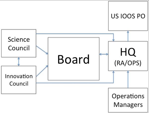
of marine and coastal ocean resources. Together, the RAs coordinate through the IOOS Association to establish
linkages to ensure that the needs of the region are reflected in national policy and priority setting.

MARACOOS is a 501 (c)(3) Non-Profit Corporation currently involving participants from 25 universities, 21
state and federal government agencies, 18 private sector partners, and 12 non-governmental organizations. The
current structure and operation of MARACOOS reflects the evolutionary history that was driven in part by initial
incremental funding that continues to promote the practice of minimizing administrative overhead and
maximizing leveraged investment. Building on more than a decade of engagement, innovation, and progress,
MARACOOS is committed to sustaining and growing the operation, integration, and evaluation of this end-to-
end regional-scale system for the Mid-Atlantic region.

Vision 2016-2021

Today, there is the dawn of a new era where sustained ocean observations are revolutionizing the way we
understand and experience the coastal oceans and recognize the mutual dependence and need for stewardship.
The challenge is to fulfill the potential inherent in a sustained fully-developed network of observational platforms
that supply data and information needed for rapid detection and timely predictions of changes in our marine and
coastal waters.

In addition to seeking the wisdom and advice of the MARACOOS Membership to develop this vision of the
future, we have consulted with a host of representatives from academia, industry, and the general public and we
have also factored in guidance provided by the IOOS Program Office. The input from all these sources has been
invaluable in developing our long-range plan. We believe this document provides a legitimate framework upon
which our program can operate in the next five years. We realize, however, that this plan is a “living” document,
and as such, will need constant revision as new events affecting our marine and coastal resources occur, as our
knowledge of important issues changes, and as our program’s ability to address issues of our stakeholders
continues to develop.

This Strategic Operational Plan demonstrates continued commitment to a process that builds and sustains an
observing system and stakeholder engagement throughout the Mid-Atlantic region. In coordination and
recognition of the overarching and societal goals of IOOS, the results of extensive stakeholder engagement and
needs assessment, MARACOOS will continue to focus on five theme areas: Maritime Safety; Ecological
Decision Support; Water Quality; Coastal Inundation; and Offshore Energy.

MARACOOS Mission: To seek, integrate, share and apply knowledge and understanding of our coastal
ocean—and will enable us to maintain our long-standing commitment to providing integrated ocean
information for a changing world. Central to accomplishment of this mission is the need to foster partnerships
in which the academic, public, and private sectors pool their human and financial resources to help protect lives,
health, and property, to promote a strong economy and jobs, and to support a healthy environment.

MARACOOS Vision: To enhance the strength, sphere of influence, and effectiveness of MARACOOS
through the building of true working partnerships. These partnerships can take many forms, including
collaborations with other regional entities, joint projects with industry, and additional co-sponsorship with other
federal and state agencies. The marine/coastal challenges facing us are far too great for any single entity to
resolve. IOOS/MARACOOS provides a constant foundation of support that can be leveraged by forming vested
partnerships. The interaction among members of the partnership enhances the knowledge and wisdom of each,
while resulting in a better response to real marine and coastal ocean problems and opportunities.

THE PLANNING ENVIRONMENT: THE MID-ATLANTIC REGION

The Mid-Atlantic Bight (MAB) extends 1000 km alongshore, from Cape Cod, MA to Cape Hatteras, NC; this
span of coastal ocean encompasses an expansive continental shelf cut by a deep cross-shelf valley and multiple
                                                                                                                 2
shelf-break canyons, large estuaries, and significant populations. Important resources are located in both the
shelf waters and the increasingly urbanized estuaries—Narragansett Bay, Long Island Sound, Hudson-Raritan
River, Delaware Bay and Chesapeake Bay. Into these estuaries, the Connecticut, Hudson, Delaware,
Susquehanna, Potomac, and James Rivers drain inputs from a significant portion of the eastern United States.
Shelf waters generally flowing along the coast from the Gulf of Maine to the south at Cape Hatteras experience
the cascading inputs from each of these rivers and estuaries. In addition to the spatial complexities associated
with shelf geometry—the long, wide ribbon of water punctuated by headlands, bays, shoals, and canyons—
temporal variability is introduced by strong and sometimes episodic forces that constantly push and prod the
Mid-Atlantic Bight. The MAB is a dynamic boundary between the less variable waters to our north and south,
with complex seasonal physical dynamics resulting in a highly variable 3-D thermal structure. These dynamics
structure shellfish and migratory fish habitats that support both commercial and recreational fisheries, and
directly impact our weather.
The Mid-Atlantic region encompasses 10 states, the District of Columbia, 107 congressional districts and the
latest US Census data indicate that ~78M people (25% of US population) live within the MARACOOS
footprint. The nation’s highest coastal population density makes increasingly competing demands for marine
and coastal resources. Ports in the region handle 25% of the total U.S. waterborne commerce, and include the
nation’s largest petroleum product hub and the world’s largest Naval base. Developed watersheds and urban
estuaries, impacted by a century of industrialization and growing coastal populations, degrade coastal water
quality and diminish recreational economies. Inundation driven by tropical storms and northeasters are year-
round threats to the large populations that live on the broad coastal plain. While the region’s electrical power
grid is the most congested in the nation, the high population density, reliable winds, and wide continental shelf
combine to support the nation’s nascent offshore wind energy development projects.
Present and future generations will be challenged by accelerating global impacts, including melting of land and
sea ice, rising sea levels, ocean acidification (OA), and deoxygenation (hypoxia), and more frequent extreme
weather. Improved knowledge of the trends and variability of our changing environment is required to address
the challenges of energy, food, water and economic security and resiliency on regional, national and
international scales. In the Mid-Atlantic, global sea level rise, along with coastal subsidence from the last
glacial retreat, combine to produce a regional hot-spot for rising sea levels, creating a higher baseline for land
falling hurricanes and devastating northeasters. Climatic warming and OA are altering MAB fish and shellfish
habitats. The Mid-Atlantic’s dense population further increases the region’s economic sensitivity to climate
change, where, for example, new rainfall patterns and more frequent extreme weather conditions are impacting
homes, businesses, farms and reservoirs.
Clearly, MARACOOS is tasked with resolution of challenging and complex environmental issues and the
societal stake in both inshore and offshore waters makes the availability of data and information supporting the
delivery of valued and timely predictions critical.
MARACOOS
Background
The Mid-Atlantic Regional Association Coastal Ocean Observing System (MARACOOS) is a 501 (c) (3) Non-
Profit Corporation currently involving representatives from 25 universities, 23 state and federal government
agencies, 18 private sector partners, and 12 non-governmental organizations. The current structure of
MARACOOS reflects its evolutionary history that was driven in part by initial incremental funding. In 2004,
funding from NOAA supported the first organizational meeting of the Mid-Atlantic Regional Association
(MARA). In 2005, the Mid-Atlantic Coastal Ocean Observing Regional Association (MACOORA), based at
3the University of Delaware was formed and chartered under the provisions of the Not-For-Profit Corporation
Statutes in the State of Delaware. MACOORA created the framework in which the Mid-Atlantic’s coastal ocean
user community identified its five highest priority regional themes:
(1) Maritime Safety, (2) Ecological Decision Support (3) Water Quality, (4) Coastal Inundation, and (5)
Offshore Energy. MACOORA established the Mid-Atlantic Regional Coastal Ocean Observing System
(MARCOOS), based at Rutgers University, to provide the necessary ocean observing, data management, and
predicting capacity to systematically address the prioritized regional themes. In 2011, these two entities merged
into one organization, MARACOOS, governed by the initial provisions of the incorporation document, creating
an academic-industry-government partnership that leverages the region’s distributed centers of critical expertise
to form an interactive, integrated regional network.
Mid-Atlantic’s coastal ocean user community identified and has reaffirmed its five highest priority regional
themes as: (1) Maritime Safety, (2) Ecosystem Decision Support, (3) Water Quality, (4) Coastal Inundation, and
(5) Offshore Energy. To support these user themes, MARACOOS has formed a NOPP-style academic-industry-
government-NGO partnership-based Regional Coastal Ocean Observing System (RCOOS) that leveraged the
region’s extensive expertise and capabilities. Operation of the integrated, regional scale observation, data
management and prediction network is sustained in real-time and gap fills national capabilities. It includes an
outreach, stakeholder engagement and education network that engages users, identifies opportunities, and
educates citizens.
Working in 5-year segments, the first 5-year cycle established a sustainable regional-scale ocean observatory
that filled gaps in the national infrastructure and supported our initial four user themes. The second 5-year effort
(2011-2016) achieved operations and evaluated an ensemble of ocean and atmospheric prediction models to
support our 5 user themes. Theme area successes include the first regional-scale network to be declared
operational for USCG Search And Rescue (SAR), the successful use of MARACOOS data and models by the
MA Fisheries Management Council to open new fisheries, DHS Impact Awards for aiding oil spill response,
discovery of coastal processes that feedback on hurricane intensities and impact inundation, and the expansion
of the observing network to enhance support for offshore wind development.
Governance
The structure and approaches of MARACOOS are designed to focus on engagement and
understanding of the stakeholder community needs; resource prioritization, and allocation of operational
capabilities commensurate with those needs. The result is a streamlined governance structure (Figure 1) that
ensures responsible oversight and management while maximizing available resources to deliver state-of-the art
products and services in the five priority theme areas.
A full-time Executive Director (G. Kuska), as Chief Operating Officer and spokesperson for the organization,
will manage the day-to-day activities of MARACOOS, supported by a small staff complement to oversee
technical operations, stakeholder engagement, and innovation-focused, applied partnerships. Further support for
MARACOOS governance is realized through matching contributions from the University of Delaware and
Rutgers University, as well as through the volunteer efforts of the member-elected Board of Directors and its
supporting councils and working groups. In addition to the Executive Director, the MARACOOS Leadership
Team will include several positions that emphasize the united nature of the regional association and observatory
arms (Figure 1).
4Figure 1: MARACOOS Organizational Diagram
The Chief Executive Officer and Chair of the Board (C. Thoroughgood) is responsible for managing Board
functions, including the maximization of the program’s intellectual and resource capital. The President and Vice
Chair of the Board (S. Glenn) is responsible for general oversight of all aspects of the ocean observatory,
including integration of regional observing programs/assets and compliance with milestone accomplishment.
The Vice Chair of the Board and Chair of the Nominations Committee (E.Kelly) is responsible for Board
member recruitment and private sector connectivity. The Chief Technology Officer and Technical Director (M.
Crowley) oversees the day-to-day management of observatory operations, including data acquisition,
management, as well as modeling and product development. For his role as MARACOOS Data Curator, M.
Crowley brings extensive OOI experience as Program Manager for the Cyber-Infrastructure (CI) data
management together with his IOOS experience to coordinate MARACOOS data lifecycle curation activities.
The Director of Stakeholder Engagement ensures direct connectivity with the MAB stakeholder communities
and leveraged engagement through partner organizations. A new position of Director of Innovation Partnerships
will be phased in over the course of the grant period to oversee an innovation initiative being launched to
enhance, develop, and maintain focused partnerships under the IOOS umbrella.
The Board composition represents a broad constituency, with members from industry, government, NGOs, and
academia, and a broad geographic distribution throughout the MAB (http://maracoos.org/board). MARACOOS
has over 60 dues-paying members, and several thousand direct-contact stakeholders, who have identified
themselves with one or more of the five priority themes. A Stakeholder Engagement Initiative provides the
formal basis for accessing and identifying regional needs and priorities via consultation with the broad range of
regional stakeholders. This initiative comprises a variety of efforts, including: a) an annual member/stakeholder
meeting; b) a series of theme-focused workshops; c) individual and group interactions across the region; and d)
leveraged interactions through allied partners’ organizations. Information is presented to the Board and the
partnership for consideration, determination, and advice on enhancements, adjustments, and maintenance of the
activities and resource prioritization within and across MARACOOS partners that ultimately guide product
development. This approach is used for general as well as specific regional needs, and has directly informed the
development of program goals and objectives in response to regional needs.
To further widen the reach and enhance the proactive nature of regional partnerships, MARACOOS has
established an Innovation Council, with the purpose of developing and sustaining new focused partnerships
under the MARACOOS umbrella. As a complement to the Innovation Council, the Science Council will advise
on the scientific validity and data quality assurance. This approach allows MARACOOS to maintain its core
strengths, while providing flexibility and a systematic pathway to engaging new partners with critical expertise
and resources. This approach will also position MARACOOS to pursue, attain, and maintain IOOS regional
certification as per 15 CFR Part 997.
5Management
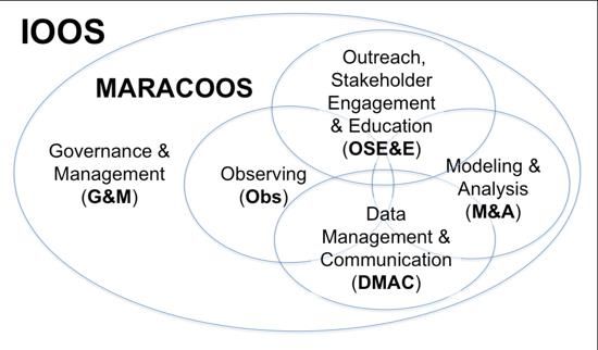
MARACOOS has a successful history of managing, operating, and integrating its 5 RA subsystems (Figure 2).
Figure 2: MARACOOS implementation of the 5 integrated subsystems that comprise an IOOS Regional
Association.
We increase participation and set priorities through user/stakeholder engagement activities ranging from large
annual meetings to sponsored topical workshops to individual contacts through our dedicated stakeholder
liaison and allied outreach entities (i.e. Sea Grant). We develop, demonstrate, and deliver new observing
technologies prioritized for sustained real-time data that are regional in scale, gap filling for the national
backbone, and quality controlled, based on national standards. Furthermore, we engage external data providers
from industry and local, state, federal and international programs to facilitate their integration into a common
operating picture for our coastal environment. We have developed and operate a standards-based data
management system that enables discovery and real-time access to data and information by users, data-
assimilative modelers, and lifecycle data curators. We operate an expanding suite of data assimilative prediction
models that are consistent with the developing national modeling framework.
Our stakeholder engagement activities, augmented by collaborations with a diverse set of vested MARACOOS
members, ensure the end-to-end delivery of MARACOOS products. Our education activities, further enabled
through NSF, focus on a) bringing real time data and information into the classrooms as well as to the marine
resource users, b) contributing to the science pipeline and c) engaging a new workforce. Our infrastructure and
professional expertise contribute to and are leveraged by numerous state and federal agencies beyond IOOS,
including NOAA (NOS-COOPS, PORTS, OCM, NERRS, NCCOS, OCS, and the NOS Roadmap; NWS-
NCEP, NDBC, WFOs/AWIPS; NMFS-NEFSC; OAR-OAP, NSGCP-SGD, CPO-CINAR; NESDIS-National
Broadband Plan; and several agency-wide programs and efforts), DHS (USCG, S&T COE), DOE (NREL), DOS
(UNESCO-IOC), EPA, NSF (OOI, OPP), NASA, Oceanographer of the Navy (Fleet Weather Center), USACE,
and USGS.
Our implementation teams contribute to national IOOS infrastructure through participation in the HFR
Technical Steering Committee, Glider DAC, federal DMAC backbone, and national modeling plan
development. Internationally, we participate in efforts that include the GEO Global HFR Network, WMO
Glider Steering Committee, NPOMS Typhoon Workshops and UNESCO’s Intergovernmental Oceanographic
Commission. Our ocean observing infrastructure is used for decision-making in 5 major user-defined theme
areas of Safety at Sea, Ecological Decision Support, Water Quality, Coastal Inundation, and Offshore Energy.
The RA is supported by scholarly productivity published in science journals, including 3 MTS and 1 CSR
special editions. Activities conform to the Programmatic Environmental Assessment best practices.
MARACOOS evaluates each program component area annually based on a number of criteria. The evaluation
process provides information needed to assess the effectiveness, efficiency, and impact of each component
within the system, and informs a decision-making process that determines additional investment, sustainment,
or retirement of individual observing assets, services, or component groups. A number of factors are considered
6in the evaluation of each component area; these include: IOOS Program Office guidance; demonstrated level of
need or use; uniqueness of service; potential for positive, significant impact; reasonable use of financial and
human resources; ability to integrate into existing regional and national networks; level of customer utility and
number of identified users; balance of partner contributions; level at which partners rely on the component area
of operations; cost of operations and maintenance; and performance record. An evaluation of component areas
using these criteria allows MARACOOS to select which projects to continue or discontinue.
Accountability and Liability
The distributed nature of MARACOOS results in there being two principal organizational and fiscal sponsors of
MARACOOS: (1) The University of Delaware, Newark, DE and (2) Rutgers University, New Brunswick, NJ.
MARACOOS has a signed Administrative Services Agreement with the University of Delaware (UD)
(http://maracoos.org/certification/doc/Administrative%20Services%20Agreement.pdf); under this agreement
UD provides all services necessary or desirable for the operation of MARACOOS business and activities. As
such, all employees of MARACOOS are employees of the UD, and their actions while under employ of the
university are seen as activities taken by the university, with associated liability and self-insurance protections
provided to employees as allowed for in University personnel policies. All actions taken by MARACOOS
employees are assessed and reviewed annually through established employee evaluation requirements —
ensuring supervisors of record are engaged in the ongoing activities of staff, and afforded the authority to hold
staff accountable for actions, while also promoting and rewarding success. With respect to liability protection
and through the Administrative Services Agreement, UD’s General Counsel’s Office is responsible to handling
damages or injury caused by UD’s agents, officers, and employees in the course of their employment to the
extent that UD’s liability has been determined by a court or otherwise agreed to by UD, and the university shall
pay for damages and injury to the extent permitted by law.
Rutgers University is currently the recipient of the IOOS Program Cooperative Agreement and as such serves as
the primary fiscal oversight body. There are no MARACOOS employees located at Rutgers University.
MARACOOS Observatory operations are coordinated through the Center for Ocean Observing Leadership in
the School of Environmental and Biological Sciences. As a research center housed within Rutgers University,
liability and self-insurance protections are provided by Rutgers University.
Program Planning and Integration
Strategic planning involving constituencies both external and internal to MARACOOS has been a long-standing
and integral component to the development of MARACOOS. The first level of external guidance for strategic
planning comes from the IOOS Program Office. With national priorities in hand, MARACOOS engages many
levels of federal, state, and local/regional governments, business and industry sectors, non-governmental
organizations, community groups, academic partners, and coastal residents of the MARACOOS region to
identify high priority issues relevant to Mid-Atlantic region. Input is gathered at community and in-person
meetings, workshops, training sessions, focus groups, through web-based feedback services and through review
of strategic plans, prioritization documents, and needs assessments compiled by partner organizations at local,
regional, and federal levels. Engagement is on-going throughout the region and MARACOOS is committed, as
is evident through its formal Stakeholder Liaison Program, to growing and maintaining a strong, diverse, and
engaged user base that provides regular inputs on needs and priorities. Through stakeholder engagement,
MARACOOS also gathers critical assessment on the effectiveness of the reginal system in satisfying its diverse
user needs. In addition to Mid-Atlantic stakeholder engagement, MARACOOS also has international liaisons
with stakeholder groups in Brazil, Korea, Spain, South Africa, Portugal, and Indonesia.
In addition to ongoing and regular contributions to needs assessments, gap identification, and priority
identification, stakeholders may choose to participate more directly in MARACOOS priority setting through the
7governance framework of the non-profit MARACOOS Corporation. It is through membership in MARACOOS
that the Board of Directors are nominated and elected. MARACOOS members populate electing cohorts,
including sub-regional, business and industry, non-governmental organizations, state and local government, and
academic representatives, and are elected to 3-year terms on the MARACOOS Board of Directors at the annual
MARACOOS business meeting.
Preparation of the Program Plan 2016-2021
MARACOOS, through its Board of Directors and rich stakeholder engagement process, sets a 5-year planning
horizon for the program, and is reviewed annually to ensure that the organization is focused on relevant,
appropriate, and timely activities while still maintaining its focus on overarching goals and objectives tied to the
national observing enterprise. The goals, objectives, and recommended actions represent a collection of
expressed needs, gathered over years and geographies, carefully matched with the capabilities of MARACOOS
Principal Investigators, Staff, and Board of Directors to create a cost-effective, operational observing system.
Continuing to build on the accomplishments and lessons learned and based on self-evaluation of our 5
subsystems and their impacts, national level guidance (via the FFO itself and the national guidance documents
quoted within), and continued stakeholder input for prioritized expansion of our activities, the goal of this third
5-year (2016-2021) planning cycle is to focus on the generation, refinement, and maintenance of new integrated
products to address expanding user needs. To that end, the following improvements/reprioritizations of our
ongoing activities will be implemented:
(1) Enhancement of the RA management team to better support the requirements of IOOS certification;
(2) Maintenance of the existing observing infrastructure, with a surge capacity capable of responding to
extreme events, while continuing to expand the ability to deliver data quality consistent with
QARTOD;
(3) Expansion of the data management and curating activities to entrain even more external data
providers into the common operating picture provided by the Data Explorer technologies;
(4) Implementation of the results of a metric-informed, user-driven prioritization of data-assimilative
prediction models for special purposes, expanding coverage to the entire Northeast U.S. Large
Marine Ecosystem (LME);
(5) to enhance new product development, awareness, and use with targeted user communities; and
(6) Establishment of entrepreneurial innovation teams to grow future cross-cutting activities that
broaden support for and enhance responsiveness to MARACOOS stakeholders.
a. MARACOOS proposes a phased series of innovation projects; annual focus points are
prioritized as follows:
i. ocean acidification (YR 1), responding to large east coast gap in national OA
monitoring and addressing documented needs of the shell fishing industry;
ii. biological monitoring/animal movements (YR2), responding directly to the IOOS
Program Office FFO’s emphasis on ecosystems, as well as addressing significant
Mid-Atlantic region user needs and augmenting NOAA fisheries observations;
iii. coastal inundation (YR3), leveraging the well-supported NYHOPS implementation of
NY Harbor and the development of new community response models in Hampton
Roads, both of which can be expanded regionally;
iv. nearshore water quality (YR4), leveraging state and county support for monitoring
hypoxia (e.g. NJ coast) and Vibrio bacteria (e.g. Long Island Sound, Chesapeake
Bay); and
v. offshore wind energy (YR5), integrating the projected state growth for offshore sine
energy development.
This Strategic Operational Plan represents the continued commitment to a process that builds and sustains an
8observing system throughout the Mid-Atlantic region. The Mid-Atlantic is a densely populated region with
diverse base of commercial and recreational ocean users. MARACOOS therefore must support multiple user-
driven themes with responsive products developed from an integrated ocean observing and prediction system.
This need led to the implementation of an integrated matrix approach, whereby a capability developed to
support a critical user need in one theme can then be repurposed to serve numerous user needs in multiple
themes. This matrix approach codifies the power of integration, has enabled a wide range of stakeholders to
enjoy the benefit of collaboration and data sharing and is increasingly being adopted by ocean observing
communities internationally.
The following section highlights the MARACOOS high priority theme areas, with their integrated stakeholder
engagement, outreach, education and DMAC components to guide the annual work plans over the next five
years and to secure Certification of MARACOOS during this same time period. The goals and recommended
actions in each section represent a collection of expressed needs, gathered over years and sub-regional
geographies, carefully matched with capabilities of the MARACOOS Principal Investigators, Staff, and Board
of Directors to create a cost-effective, operational ocean observing system for the Mid-Atlantic. The
comprehensive list of priorities includes the following:
MARACOOS Priority Focus Areas
(1) Ensuring MARITIME SAFETY AND RESILIENCY
(2) Providing ECOLOGICAL DECISION SUPPORT by supporting commercial and recreational
FISHERMEN
(3) Helping maintain WATER QUALITY
(4) Protecting against COASTAL INUNDATION
(5) Supporting OFFSHORE WIND ENERGY
MARACOOS PRIORITY FOCUS AREAS
1. ENSURING MARITIME SAFETY AND RESILIENCY
Background
The general goals associated with this focus area include:
(1) Supporting emergency rescuers by defining smaller search areas and assisting people more
quickly with a greater chance of preserving life and property;
(2) Monitoring vessels by supporting DHS protection for life and property; and
(3) Providing safe navigation by supporting NOAA PORTS products for ship pilots.
The U.S. Coast Guard (USCG), for its Search And Rescue (SAR) mission, responds to over 28,000 incidents
with over 5,000 lives saved each year. The Search And Rescue Optimal Planning System (SAROPS) is the
protocol used to respond to these incidents. The effectiveness of SAROPS to define search areas depends
critically on the observed real-time and prediction surface current data that are delivered through their
Environmental Data Server (EDS). The USCG SAR operators are trained in SAROPS and educated in modern
ocean observation and regional current conditions. Similarly, the U.S. Lifesaving Association (USLA), for rip
current safety mission, estimates that nearshore rip currents are responsible for over 100 deaths per year—the
primary cause of drowning along U.S. coasts. Over 80% of the more than 12,000 annual lifeguard rescues are
related to rip currents. The National Weather Service Weather Forecast Offices (NWS WFOs) provide daily rip
current guidance to lifeguards through a rip current warning system. The accuracy of the NWS rip current
forecasts depends critically on the observed nearshore waves and currents that go into their statistical models.
The primary data need in this regard is the alongshore drift direction and nearshore waves.
Maritime safety was the highest MARACOOS priority area during its initial years. MARACOOS and
9recreational fishers jointly developed the broad support necessary to partner with NOAA’s National Data Buoy
Center (NDBC) to deploy a weather buoy that provides ocean/atmosphere environmental data at the seaward
end of the Hudson Canyon, improving fishing safety. Advances in port and harbor maritime safety continue
through the execution of a preliminary data sharing agreement between Stevens and NOAA CO-OPS.
Developed at the request of NY USCG Harbor Ops committee, under the agreement, Stevens will deliver full
water column current observations from 3 locations in NY Harbor to CO-OPS at the required NOS standards
for integration into the PORTS system and use by harbor pilots. The agreement leverages instrumentation
funded by the NJDOT OMR for integration into the NYHOPS - MARACOOS observing system and serves as a
prototype agreement for other harbors in the region.
The USCG Office of Search and Rescue and MARACOOS have jointly demonstrated that surface current maps
improve the effectiveness of SAROPS. In a simulated search case, using a USCG surface drifter released south
of Long Island, the USCG used surface currents from an operational HYCOM model and the MARACOOS
HFR respectively with their SAROPS. The HFR surface current-derived search area was centered on the drifter
and was three-times smaller than that derived from the HYCOM simulation. Thus in spring 2009, HFR surface
current data were installed on the USCG EDS for use as an operational component of SAROPS, an important
first step toward a national capability. The USCG estimates that 50 additional lives will be saved each year after
the national implementation of the HFR surface current network. The indirect benefit is that USCG assets,
which are typically redirected to SAR missions, will spend more time on their law enforcement and homeland
security missions.
Since HFR and the Short Term Prediction System went operational with the USCG for search and rescue in the
Mid-Atlantic in 2009, MARACOOS has consistently exceeded the USCG 80-80 metric for data availability in
SAROPS. In 2014, MARACOOS provided data to the USCG as it carried out 247 SAR cases with 96 lives
saved and 319 lives assisted. Encouraged by the USCG and others, HFR demonstration projects are
transitioning new products into NOAA PORTS systems for NY Harbor, Chesapeake Bay and San Francisco
Bay to support safer port operations.
Goals and Objectives: The Next Five Years
Goals and Objectives
Overarching Goal: To increase availability and use of high quality data products for search and rescue
personnel, maritime transportation operators, and recreational boaters.
Objectives:
1. Ensure 80/80 coverage of HFR
2. Enhance data quality through:
a. Integration of the bistatic vector measurements into regional products
b. Increasing the Lagrangian trajectory modeling skill of the radar network
c. Development and application of additional QA/QC procedures, including QARTOD
d. Commencing real-time automated QA/QC of the radial and total surface current
measurements
3. Maintain data product availability via HFR, DAC, STPS, NDBC; and enhance OceansMap to
expand functionality and access
4. Develop and execute engagement, education plans for tutorials with USCG and maritime pilots and
identify changing needs to enhance data use
5. Monitor data product use through automated reporting of user surveys
2. PROVIDING ECOLOGICAL DECISION SUPPORT BY SUPPORTING COMMERCIAL AND
10RECREATIONAL FISHERMEN
Background
The general goals associated with this focus area include:
(1) Minimizing bycatch and catch full quotas by creating predictive habitat models to inform
fishermen about areas of high bycatch;
(2) Developing customized web and mobile applications, integrating historical catch information
with real-time data and predictions to improve performance and reduce fuel use; and
(3) Supporting ecosystem-based fisheries management through
a. incorporating of MARACOOS maps of observed and modeled oceanographic
variables into stock assessments,
b. tracking anoxic zones for resource managers,
c. helping fishermen avoid anoxic zones, and
d. reducing scope of fishery closures
Among the many issues requiring improved Ecological Decision Support, MARACOOS has focused its
attention on fisheries and will continue to do so over the next five years. Direct, indirect, and induced economic
impacts of commercial and recreational fisheries in the MAB are substantial with commercial fish landing
values averaging close to $1.0 billion/year, and annual recreational fishing estimated at $7.4 billion/year.
MARACOOS has worked with the fisheries community to incorporate environmental observation and
prediction fields to support more informed management of this valuable resource.
MARACOOS has worked with sectors of the fishing community to identify effective ways to use
environmental observations and predictions. These products enable offshore recreational fishers to fish more
safely and commercial fishers to fish with reduced take of bycatch, less disruption of the environment, and more
fuel-efficient operations. In the early 1990s, daily real-time satellite Sea Surface Temperature (SST) maps were
made available to the MAB recreational and commercial fishing communities. More recently, MARACOOS,
with input from different sectors of the fishing community, has defined and built more useful satellite SST
products and web-based interfaces. Leveraging IOOS supported regional ocean observing assets in the MAB
with research support from the Fisheries and The Environment (FATE) program, NOAA NEFSC and
MARACOOS researchers were able to construct statistical models that linked fish abundance with observed
pelagic habitat variables. Through direct interaction with the management community, these models are now
being applied as a habitat-based approach to reduce butterfish bycatch in the squid fishery throughout the MAB.
The result of the MARACOOS Mid-Atlantic Bight habitat modeling effort was a “term of reference” (ToR) in
the 59th NEFSC stock assessment review. As written in the final report of this review, “this ToR was met.” The
review panel stated that the MARACOOS analysis was “rigorous and highly innovative.” Following the panel’s
advice, the MARACOOS method has been included in the SARC 60 assessments of bluefish and scup in 2015.
Further, 2014 was the first year of a small, directed fishery for butterfish, with a landings limit of 3,200 mt. This
limit represents revenues of approximately $4.7 million (at 2013 average prices). Under the proposed 2015
specifications, the average landings limit for 2015-2017 would be 21,408 mt, or potentially $31.7 million
additional ex-vessel revenues (at 2013 prices), with a significantly higher overall economic benefit through
post-landing multiplier effects.
Animal telemetry and tracking is a rapidly growing field that can provide information on the distribution of
animals and, in combination with observing technologies, oceanographic conditions the animals inhabit.
Telemetry data standards are emerging in the regional community (ATN, OTN, MATOS, ACT) and there is
broad interest in annotating animal locations with oceanographic data provided by IOOS.
Goals and Objectives: The Next Five Years
11Overarching Goal: To increase availability and use of high quality data products for fisheries managers,
fishermen, and living marine resource managers
Objectives:
1. Target engagement with fishermen and managers to identify areas and species for enhanced new
data products and training and tutorials
2. Establish and support MATOS Integrated Animal Telemetry Users Council
a. Host a workshop focused on telemetry data annotation to encourage the integration of
oceanographic and telemetry data in the MARACOOS region.
b. Based on workshop input, acquire fisheries acoustic tags and glider based receivers and
passive acoustic systems for sensing and reporting fish and marine mammal occurrence.
c. Deploy acoustic and satellite tags (YRs 3-5) with our telemetry partners, incorporate the
passive acoustic (DMON2) sensors in MARACOOS glider surveys, and deploy two
additional active and passive acoustic gliders for fish and marine mammal surveys (1 long-
term, near-shore lithium mission in the fall, and one offshore alkaline mission in the winter).
3. Enhance data quality through:
a. Refinement of Doppio domain for the data-assimilative ocean model
b. Regular 3-day predictions for Cape Hatteras to Halifax initialized via ROMS 4DVAR DA
c. Quantifying prediction uncertainty using intra-model ensembles
d. Deploying 3 gliders during the stratified season each year
e. Developing and applying QA/QC procedures, including QARTOD
4. Deploy and maintain enhanced OceansMap to expand functionality and access
3. HELPING MAINTAIN WATER QUALITY
Background
The general goals associated with this focus area include:
(1) Monitoring water quality via satellite imagery, surface current radar, robotic glider fleets,
drifters, buoys, air-quality sensing, and computer modeling
(2) Tracking sewage, pollution, and oil spills, providing predictions to support beach and coastal
managers and enabling rapid response
(3) Determining beach closings through the use of gliders and buoys monitoring toxic algal
blooms, anoxic zones, and water temperatures
The Mid-Atlantic Bight has a wide range of water quality issues spanning low dissolved oxygen harmful algal
blooms, and low pH water that vary in importance across the region. Given the connection of these issues to the
large population of the Mid-Atlantic region, most water quality issues are located in estuaries and along the
coast. This situation localizes the need and application of water quality product development. MARACOOS
will continue to facilitate the connection between the regional IOOS and the work of local stakeholders to fill
local needs with specific focus on the major bays within the MARACOOS footprint.
MARACOOS long-term support of water quality product delivery is expressed through a series of technical
interactions with the water quality community across federal, regional, state, county and local agencies and
governments. Since 2006, MARACOOS, in partnership with NOAA and others, have hosted water-quality
workshops to encourage the development of effective water quality products on all scales. At the federal level,
the effectiveness of IOOS and National Water Quality Monitoring Network (NWQMN) interaction has been
demonstrated through the initiation of the Delaware Bay Pilot Project. At the state level, the NJDEP and
USEPA are funding dedicated glider deployments that leverage IOOS investments in the region. At the county
level, the same MARACOOS HFR network that serves the USCG is used to monitor river plumes to warn of
12possible water quality impacts on recreational beaches. Leveraged data products such as these have been
developed in response to specific needs of water quality professionals with local interests.
These interactions demonstrate the benefit of leveraging the regional assets for improved monitoring of the
inner shelf and estuaries to support local water quality applications. MARACOOS has helped identify priority
observations that could improve water quality in the MAB, through its collaboration with the NWQMN via
collaborations with USGS. The collaboration has enabled product development such as the U. Delaware
MARACOOS satellite based chlorophyll product that was used in late August this year to detect a large
phytoplankton bloom off coastal New Jersey. A grant from USEPA, Region 2, in cooperation with NHDEP
Marine Monitoring, supported a glider deployment that provided critical subsurface data. The USEPA and
NJDEP used MARACOOS modeling support from Stevens to build a 4-D representation of the bloom that
identified potential water quality impacts throughout the water column. In another example, at the request of
NJDEP, MARACOOS used surface current observations, combined with regional ocean model predictions, to
successfully back-track the source of medical wasted discovered off an Atlantic County beach. In 2011,
MARACOOS supported NY and NJ authorities as they managed their response to an 8-million-gallon raw
sewage spill in the Hudson River. A year later, MARACOOS HFR observations and NYHOPS predictions
supported water quality issues in the harbor and along the coast, ranging from sewage and trash spills to debris
plumes following Hurricane Sandy. MARACOOS, through the Chesapeake Bay Interpretive Buoy System
(CBIBS), supports water quality monitoring (oxygen) along the full 250 km length of the Chesapeake Bay.
These are but a few examples of the quality of products and services that come from strong partnerships with
the growing water quality user community throughout the MAB. There is now growing interest in water quality
as related to ocean acidification on the shelf and Vibrio in the estuaries impacting the shell fishing industry, the
Mid-Atlantic regions largest commercial fishery. These two new issues will be addressed in the 2016-2021
period.
Goals and Objectives: The Next Five Years
Overarching Goal: To increase availability and use of high quality data products for federal and state shellfish
authorities, and beach/recreational managers.
Objectives:
1. Convene local workshops to identify and prioritize water quality needs.
a. Water Quality Working Group hosted meetings in each of the major bays (Chesapeake,
Delaware, Hudson, Long Island, and Narragansett) to develop local strategies to best
leverage MARACOOS assets to fill existing data gaps (YRs 1-2).
b. Implement priority strategies identified in workshops (YRs 3-5).
2. Partner with NOAA Pacific Marine Environmental Laboratory (PMEL) collaborators in the
development and deployment of the first moored Ocean Acidification (OA) buoy in the MAB shelf
waters.
a. Measure carbonate chemistry and other physical, biological, and water quality parameters.
3. Plan user need identification and product training by:
a. Supporting intergovernmental pilot for Long Island Sound Water Quality database for Vibrio
forecast
b. Convening partners to develop a Mid-Atlantic Ocean Acidification Network
c. Adapting Choptank Habitat Pilot project for implementation in other regional watersheds.
4. Enhance data quality through:
a. Leveraging yearly glider deployments to measure water quality parameters
b. Development and application of additional QA/QC procedures, including QAPP and
QARTOD
c. Commence real-time automated QA/QC of the radial and total surface current measurements
5. Deploy and maintain enhanced OceansMap to expand functionality and access
134. PROTECTING AGAINST COASTAL INUNDATION
Background
The general goals associated with this focus area include:
(1) Predicting storm surge and hurricane intensity by providing this information to emergency
managers responsible for protecting lives, health, and property;
(2) Developing accurate predictions of inundation and delivering atmospheric models and real-
time validation of surface data via the MARACOOS Asset Map and website;
(3) Monitoring water levels and transmitting real water gauge date via the MARACOOS Asset
Map and website.
Following the 2005 IOOS/MARACOOS inundation workshop, the Chesapeake Inundation Prediction System
(CIPS), in response to the needs of emergency managers, constructed a real-time prediction system with storm-
surge visualizations down to street-level spatial resolution. CIPS formed a government, academic, and private-
sector partnership to produce the predictions and deliver the information to the emergency managers to enhance
their ability to respond to surges or sea-level rise. This partnership successfully used an ensemble approach that
improved the accuracy of both atmospheric and water-level predictions. One of the primary goals of CIPS was
to take the lessons learned from the local Chesapeake case to expand inundation predicting throughout the entire
Mid-Atlantic Region. The inherently small spatial scales of inundation and the need to deal directly with the
user community dictate that it will continue to be a fundamentally local process. However, significant
improvements in accuracy and efficiency will accrue to these local efforts by addressing the issue from a
regional perspective.
Coastal and estuarine inundation modelers will be able to improve their predictions by exploiting MARACOOS
ensembles for their offshore boundary conditions. These local models are inherently more accurate because they
assimilate real-time MARACOOS observations to improve estimates of upper-ocean heat content and the
thickness of the wind-driven layer. In addition, coastal and estuarine inundation modelers can reduce their
prediction uncertainties by exploiting the full ensemble of MARACOOS atmospheric forcing products. All
these resources will be readily available for delivery from the MARACOOS servers via OPeNDAP. CIPS
showed that the delivery of these products to the emergency manager in a form that can be used is at least as
important as accuracy of the predictions. For this reason, MARACOOS will be able to facilitate local
inundation efforts not only through delivery of regional modeling products, but also through transferring the
lessons learned through the CIPS experience of working with local emergency managers to inundation efforts
throughout the region. In addition, MARACOOS demonstrated the improving accuracy of surface wind fields
through the continuing collaboration of WeatherFlow and the regional NWS Weather Forecast Offices.
WeatherFlow continues to collaborate with the NWS Forecast Offices within the MARACOOS domain to build
an increased understanding of surface wind fields. The ultimate goal of this effort is to build high resolution and
accurate gridded wind fields for meteorological applications. This product will have broad application with the
overall IOOS community.
Global sea level rise along with coastal land subsidence from the last glaciation combine to produce some of the
fastest rising regional sea levels worldwide. Norfolk is currently ranked tenth in the world in assets exposed to
increased flooding due to sea level rise, with city officials estimating over $1billion required to repair
infrastructure and keep water out of homes and businesses. Long-term sea level rise also creates a rising
baseline for inundation and flooding that require accurate inundation predictions—for rainfall, as in Hurricane
Irene (ranked eighth with >$15B in damage), and for storm surge, as in Hurricane Sandy (ranked second with
>$60B in damage). Demonstrating regional collaboration, NYHOPS, with RU-WRF-predicted atmospheric
forcing, produced the most accurate storm surge predictions for Sandy. Based on these and other successes, the
14NYHOPS ensemble operations have leveraged MARACOOS to garner City of New York support (well beyond
typical regional funding levels) to make even more accurate storm surge predictions in the future.
The recent Hurricanes Sandy and Irene not only demonstrated immense destructive power to coastal regions in
the Mid-Atlantic Bight and Northeast, but also revealed the crucial need for improved storm surge prediction
and information delivery to save lives and property in future storms. Emphasis will be given to activities
designed to improve hurricane intensity and storm surge models.
Goals and Objectives: The Next Five Years
Overarching Goal: To increase availability and use of high quality data products for federal, state, local, and
private entities for infrastructure protection and flood control, and federal and private
weather entities.
Objectives:
1. Use local scale models, including the unstructured FVCOM (Finite-Volume Community Ocean
Model) and the New York Harbor Prediction System (NYHOPS) model to predict storm surges
along the open coast of the Mid-Atlantic Bight and major estuaries.
a. Conduct high-resolution inundation simulations at high-risk areas such as New York/New
Jersey Harbor, Barnegat Bay, NJ, Norfolk, VA, and the Eastern Shore of Maryland.
i. Product ensemble prediction of storm surges and coastal inundations.
ii. Use visualization software to develop static and animated images depicting
inundation at the street level.
2. Develop engagement plan for identification of user needs and product use training and tutorials.
3. Enhance data quality through:
a. Adding realism in model physics (surface wave effects and atmospheric pressure influence)
b. Development and application of additional QA/QC procedures, including QARTOD
4. Deploy and maintain enhanced OceansMap to expand functionality and access
5. SUPPORTING OFFSHORE WIND ENERGY
Background
The general goals associated with this focus area include:
(1) Siting and maintaining offshore facilities factoring in wind, wave, and current information
from regional observations and models;
(2) Supporting onshore energy utility decisions, working with state regulators using
MARACOOS sea breeze estimates to support day-ahead energy market predictions,
ultimately saving money for utility rate payers.
\
Academic and industry weather forecasters in the MAB have over a decade of experience collaborating with the
land-based energy industry. These collaborations have provided forecasts of summertime sea-breezes used to
estimate day-ahead power consumption for improved generation efficiency, and year-round forecasts of severe
weather to reduce down time from electrical grid damage. Forecasts are typically delivered through a website
with an on-call meteorologist during events. The collocation of large coastal populations with Class 4 winds
offshore make the MAB the most viable U.S. location for offshore wind energy to succeed. Nearly all Mid-
Atlantic States already have plans in place for offshore wind resource development, with some exceeding the
national target of 20% renewables by 2030. MARACOOS has responded by hosting participants from the
offshore wind industry at their annual meetings as well as a dedicated stakeholder meeting to assess their ocean
observing needs. MARACOOS PIs have been requested to serve on state implementation panels throughout the
15region. Through these needs assessments and service opportunities, MARACOOS has learned that developers
and regulators need improved understanding of the wind resource derived from high-resolution sea-breeze
resolving predictions, delivered as maps, and used as input to state GIS systems for wind farm site planning.
Additionally, local estimates of the wind resource and environmental conditions must be delivered as time
series for historical analyses, financing, permitting, construction and operations. Better data are also needed to
assess the risk of waves, currents, salt spray, and biofouling on the offshore wind farm system. Companies are
assessing the cost of operation and maintenance and require wave height information to determine the number
of days per month they can be working onsite and how much scour to expect around power cables and
structures. Once wind farms are operating, they will need detailed and accurate wind, boundary layer, wave and
current observations, and, most importantly, accurate weather predictions to compete on the day-ahead market.
The benefit to society are the improved estimates of the wind resource and environmental data for wind farm
siting, improved construction/operation, and improved power generation predictions.
Leveraging IOOS capabilities and expertise allows individual states to make cost effective investments in new
observing system components to support the developing offshore energy industry. For example, the NJ Board of
Public Utilities (NJ BPU) recommends state support for the RU-WRF weather forecasts and a nested high-
resolution HFR network covering the inner shelf of southern NJ. The state funded enhancement of
MARACOOS will provide a more detailed analysis of the wind resource for marine use planning, and will
develop a state-of-the-art predicting capability for the day-ahead energy market that ultimately will reduce
utility costs for the NJ rate-payer.
In 2015, a 5-turbine windfarm project off Block Island was initiated. Development is being pursued offshore of
several MAB states, with future estimates running as high as 3000 turbines in Mid-Atlantic offshore windfarms.
NJ Board of Public Utilities continues to support MARACOOS product enhancements in NJ, including the RU-
WRF atmospheric prediction to generate detailed wind resource statistics, while contributing to the
MARACOOS ensemble, and four HFR sites to enhance MARACOOS nearshore current products in the vicinity
of the planned NJ windfarms.
WeatherFlow will act as a private sector partner with specialized expertise in coastal and marine weather
observations and modeling. They will assume the lead on creating, updating, and disseminating an ensemble of
multiple meteorological models over the MARACOOS domain, handling the integration of model members and
the calculation of model ensemble output. They will also run statistical performance verifications on the
ensemble members, using WeatherFlow and selected other observational data to compare predicted versus
observed values as a way to assess model performance. WeatherFlow will run the analysis processes and
provide the resulting statistics to MARACOOS for display on its system.
Goals and Objectives: The Next Five Years
Overarching Goal: To increase availability and use of high quality data products for federal and state renewable
energy entities, private energy companies, and private wind energy developers.
Objectives:
1. Develop engagement plan for identification of user needs and product use training and tutorials.
2. Enhance data quality through:
a. Leveraging regional atmospheric prediction models to form the MARACOOS ensemble
b. Providing validation statistics on ensemble components based on federal, state, and industry
network
c. Development and application of QA/QC procedures, including QARTOD
3. Deploy and maintain enhanced OceansMap to expand functionality and access
MAINTENANCE AND ENHANCEMENTS OF EXISTING MARACOOS SUBSYSTEMS
16You can also read